Embed Size (px)
Citation preview
Page 1 of 6
THE COMMONWEALTH OF MASSACHUSETTS
WATER RESOURCES COMMISSION
100 CAMBRIDGE ST., BOSTON MA 02114
WATER RESOURCES COMMISSION DECISION
AND REPORT OF ITS FINDINGS
Amendment to the September 13, 2001
Interbasin Transfer Approval
Foxborough Witch Pond Wells
July 11, 2013
INTRODUCTION
On September 13, 2001, the Massachusetts Water Resources Commission (WRC) approved, with
conditions, the town of Foxborough’s request for an Interbasin Transfer for two proposed wells
adjacent to Witch Pond, in the Ten Mile River basin. The transfer was approved for 1.44 million
gallons per day (mgd). The Interbasin Transfer Act (ITA) was triggered because the wastewater
generated from these wells would be discharged to the Mansfield regional wastewater treatment plant in
the town of Norton, in the Taunton River basin. The conditions of the 2001 approval included certain
thresholds to shut down pumping when water levels in the wetlands approached critical levels and
required one year of baseline monitoring before the wells could be placed on-line. The 2001 WRC
Decision on the Foxborough request can be found at
http://www.mass.gov/eea/docs/dcr/watersupply/intbasin/foxdec.pdf.
Based on review of baseline (pre-pumping) water levels from the site and data from the period since the
wells have been operating, the WRC finds that there is an unexpected hydraulic response to pumping
occurring in the wetland peat and a shift in wetland plant species to plants which tolerate a dryer regime.
Therefore, the WRC has required additional protection for the Atlantic white cedar swamp surrounding
the Foxborough Witch Pond wells. This will be accomplished through the addition of a deep peat
threshold to shut the wells off when the water level in the deep peat adjacent to Witch Pond is at or
below an elevation of 153.3 feet.
BACKGROUND
Foxborough’s Witch Pond Wells are located in the headwaters of the Bungay Brook subbasin of the
Ten Mile River basin, in and on the edge of the Witch Pond Swamp (Figure 1). The drainage area of
the Foxborough well site is approximately 0.25 square miles. The surficial basin divide between the
Ten Mile River and Taunton River basins does not function as a ground water divide, as there is
indication that ground water flows from Lake Mirimichi in the Taunton River basin, providing
recharge to Witch Pond (in the Ten Mile River basin) and thereby contributing flow to Bungay
Brook.
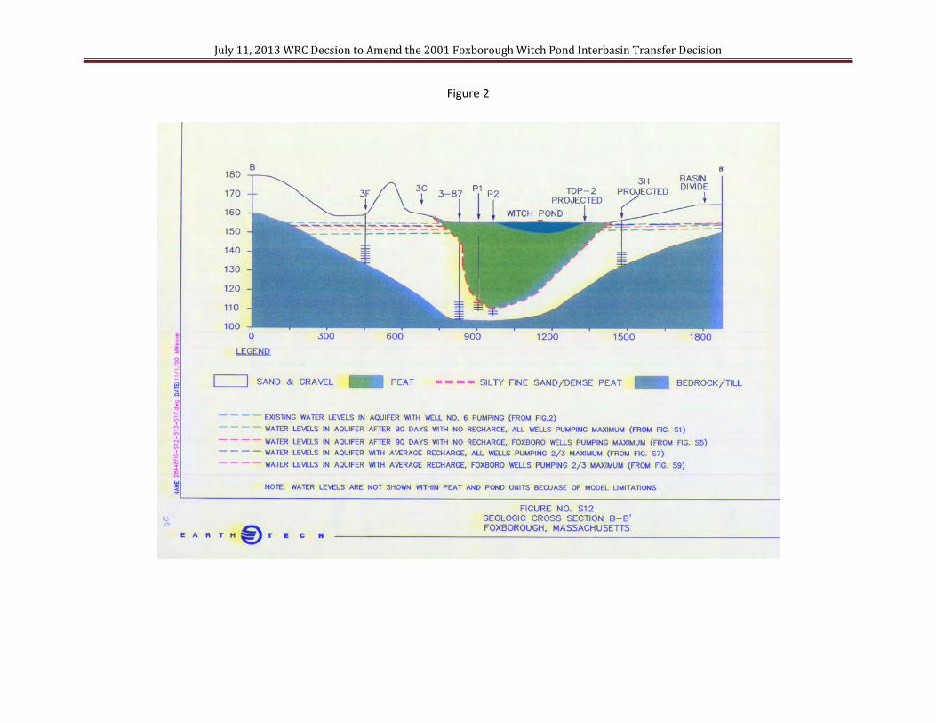
Witch Pond Swamp is perched on a peat layer of variable thickness (observed to be up to 40 feet
thick on the west side of Witch Pond). The base of the peat layer was observed to be underlain by a

Page 2 of 6
low-permeability silt layer at several locations. At the time of the ITA review in support of the
WRC’s 2001 Decision, it was thought that the silt layer would act as an aquitard, providing
protection to the swamp from the effects of pumping from the underlying aquifer. A schematic
geological cross-section of the proposed well site is depicted in Figure 2. A wetland restoration
program was also in process at the time of the Foxborough ITA review, to the south of the
Foxborough wells.
An Atlantic white cedar swamp exists within the Witch Pond Swamp wetlands surrounding the
Witch Pond wells. This swamp serves as a unique habitat for the Hessel’s Hairstreak butterfly. At
the time of the ITA approval, both the Hessel’s Hairstreak and spotted turtle (also present at the site)
were protected under the Massachusetts Endangered Species Act. The spotted turtle has since been
removed from the Massachusetts Endangered Species List, however, this is due to the success of the
protection that has been given to its habitat statewide. Hessel’s Hairstreak is obligate to the Atlantic
white cedar ecosystem, making water level impacts that would alter the hydrologic characteristics of
the swamp and allow invasive species to overtake the wetland unacceptable at this site. Hessel’s
Hairstreak is dependent upon flowering shrubs in the understory of the Atlantic white cedar swamp
ecosystem as a food source or nectary. The general hydrologic requirements of the Atlantic white
cedar swamp surrounding the Foxborough Witch Pond wells include periodic inundation and near-
surface water table conditions. Seasonal inundation precludes invasion by red maple and other
species that are intolerant of wet conditions. Seasonal inundation is dependent upon precipitation
events and was not expected to be significantly influenced by the Witch Pond wells. The Decision
required the use of shut-off thresholds for the wells to maintain ground water levels in the Atlantic
white cedar swamp in its natural state.
The hydrology and ecology of the site are complex. In addition to Foxborough’s wells, the Town of
Mansfield has a well field to the south, adjacent to the Witch Pond Swamp. The City of Attleboro
releases water from Lake Mirimichi in Plainville, and subsequent to the Foxborough Witch Pond
Wells ITA, the Town of Plainville developed a 0.4 mgd wellfield adjacent to Lake Mirimichi.
In the 2001 Decision, the WRC determined the following:
• The exact recharge mechanisms between Lake Mirimichi, Witch Pond, and the sand and
gravel aquifer are not well understood. The wells appear to have the potential to induce
ground water recharge across the basin divide by their hydraulic influence.
• Because of the Foxborough Witch Pond wells’ proximity to the Atlantic white cedar swamp,
Witch Pond, and the wetland restoration area, the Witch Pond Wells could have hydraulic
influence on the surrounding wetlands. Seasonal inundation was expected to continue to
occur as a result of local precipitation. It was thought that the effects of drawdown would be
most pronounced immediately surrounding the wells.
• From the data provided, the silty layer between the sand and gravel aquifer and the peat
seemed to minimize hydraulic interaction between the ground water and the surface water
features in most locations. It was believed that this would buffer impacts from pumping on
the wetlands.
• From the review of the information provided in support of Foxborough’s application, it was
expected that the impacts of the proposed Witch Pond wells could be controlled to protect
environmental resources using thresholds and a monitoring program. Another purpose of the
monitoring program was to verify expected conditions at the Witch Pond wells site.
Threshold water table levels would be used to control impacts of pumping on nearby surface
water resources. Use of the wells would be curtailed when the thresholds were reached, even
if natural dry conditions were the cause of the thresholds being reached.

Page 3 of 6
• Periodic vegetation monitoring in the Atlantic white cedar wetland was also required to
provide an indication of pumping impacts as indicated by a shift to plants more tolerant of
dryer conditions.
In its application, Foxborough stated that “although significant drawdown of aquifer levels is
apparent, the wetlands and pond will be buffered from this impact by the confining unit (silt layer)
underlying the wetland.” There was a lack of quantitative empirical data to fully support this
conclusion. In its Decision (page 21), the Commission stated that if “Foxborough’s conclusion
regarding water level impacts in the swamp (was) incorrect, and unacceptable conditions develop(ed)
in the wetlands or in Witch Pond as a result of pumping, the Town would have to cease well
operations.” Therefore the WRC recommended that Foxborough conduct “additional pumping tests
to verify the hydraulic response between the aquifer and the wetland near the pumping wells, prior to
committing to site construction.” Foxborough did not take advantage of this recommendation.
OTHER ISSUES CONSIDERED
Foxborough is addressing issues with an excess of iron (Fe) and manganese (Mn) in its public water
supply system. A treatment plant at Foxborough’s Oak Street well field is being constructed, causing
the shut-down of four wells. Currently, the Witch Pond wells are Foxborough’s only source of water
treated for iron and manganese removal (greensand filtration). Although these elements are
considered “secondary contaminants” by EPA and MassDEP, and do not have maximum
contaminant levels, there are some health concerns with Mn. US EPA recommends that the lifetime
health advisory value of 0.3 mg/l for Mn be used for the general populations as well as for an acute
exposure of 10 days infants to up to 6-months of age. Fe and Mn also cause aesthetic issues.
Foxborough has requested that the WRC postpone implementation of a deep peat threshold until after
the completion of the Oak Street treatment plant (Fall 2013). With the Oak Street wells already off-
line, Foxborough would have difficulty meeting demand due to both quality and quantity issues, if
the existing or proposed triggers for shutting off the Witch Pond wells are tripped. This could
jeopardize public health and safety. Therefore, on May 7, 2013, MassDEP and Foxborough met to
discuss this situation and determined that an Emergency Declaration would be the appropriate avenue
to address the issue. On May 31, 2013 Foxborough requested an Emergency Declaration from
MassDEP. Subsequent to this ITA Decision, MassDEP issued a formal Declaration on July 17,
2013. This could result in use of the Witch Pond Wells during the six-month period the Emergency
Declaration is in effect, even if the thresholds have been tripped. Operations under an Emergency
Declaration are specifically exempt under the ITA.
The Emergency Declaration memorializes the outdoor water use restrictions which Foxborough
implemented starting May 1, 2013 and provides a protocol for use of the Witch Pond wells due to
water quantity and/or quality issues even if the operational thresholds for shutting down the wells
have been triggered. Under this protocol, if Foxborough cannot pump a sufficient volume to meet
demand or provide water of adequate quality with the Witch Pond wells offline, prior to reactivating
the Witch Pond wells, and depending on the reason for reactivation, Foxborough must:
• Rule out the option to purchase water from other surrounding communities via the existing
emergency connections;
• Maximize pumpage from Foxborough’s other sources which are currently in operation;
• Impose tighter restrictions on outdoor water use, up to a total ban on any outdoor water use.
(A total outdoor water ban will be implemented when Witch Pond wells are used and the
thresholds are exceeded.)

Page 4 of 6
• Provide an update on completion of the treatment plant at the Oak Street Station and
reactivation of Wells 7, 8, 9 and 10.
• Conduct more frequent sampling and analysis for Fe and Mn.
• Continue monitoring and reporting water levels in the Witch Pond observation wells in
accordance with the approved monitoring plan.
WRC DECISION
Once the Emergency Declaration expires, expected on January 17, 2014, a threshold for shutting off
the wells must be implemented in the deep peat layer adjacent to Witch Pond at the location of
piezometer F7-PD when water elevations in this layer are at or below 153.3 feet. The water levels in
this piezometer (indicating hydraulic pressure in the deep peat layer) have responded almost exactly
the same as the underlying aquifer at this location during very dry periods in the summer of 2010.
This response suggests that water is flowing from the peat into the aquifer. The hydraulic response
in both the shallow and deep peat at this location have exhibited a downward trend between 2007 and
2012, at the same rate as the aquifer. The downward trend was expected in the aquifer formation as a
result of pumping the wells, but the peat was not expected to respond to pumping at the same
magnitude as the aquifer.
BASIS FOR THE WRC DECISION
This Decision is based on the following considerations. Criterion #5 of the Interbasin Transfer Act
requires “that reasonable instream flow in the river from which the water is diverted is maintained,
said reasonable instream flow shall be determined by the commission in making its determination of
applicability of the proposed interbasin transfer of water.” The regulations (313 CMR 4.05(5))
require that:
The Commission shall take into consideration in determining reasonable instream flow the
impact of the proposed interbasin transfer on the streamflow dependent ecosystems and water
uses to include:
…
(d) Significance of indigenous and anadromous fisheries and fauna and effects thereon.
(e) Significance of wetlands and dependent flora and fauna and effects thereon.
…
Because of the uncertainty involved in approving this proposal, the Commission conditioned the
Decision to state:
• … If alteration of the habitat or evidence of increasing invasive species in the Atlantic white
cedar swamp above the trend observed in control sites is found and can be related to use of
the well, or impacts to Witch Pond levels or flow in Bungay Brook occur, pumpage of the
Witch Pond wells may be restricted accordingly. (Condition 6 under Criterion #5)
• Foxborough must commit to abiding by any restrictions that may be placed on the use of the
Witch Pond wells as a result of monitoring. (Condition 7 under Criterion #5)
The data provided by Foxborough through the monitoring program show the following:
• Hydraulic pressure measured in deep peat piezometer F7-PD was essentially equivalent to
that in the underlying aquifer (measured in piezometer F7-D) during the dry summer period
of 2010. The WRC was concerned that this represented more hydraulic communication
between the aquifer and the deep peat than expected. Foxborough’s consultant felt that
piezometer F7-PD was incorrectly situated in the aquifer, and in June 2011 pulled it up by

Page 5 of 6
three feet. The Town has suggested that the data recorded at this point prior to this action
(2010) is not representative of the deep peat layer. However, Appendix A of the Witch Pond
Baseline Monitoring Report (September 2009) shows that the peat was encountered from the
surface to a depth of 39.0 feet, below which the sand aquifer was encountered. Well
installation data shows the screen (open area in contact with the geologic formation) for F-
7PD was set between 36 and 38 feet of depth. See Figures 3 a & b. The WRC’s
interpretation is that the looseness of the peat as described in the boring log represents a
relatively high hydraulic conductivity, and thus the apparent hydraulic connection with the
aquifer. A long-term downward trend between 2007 and 2012 in the deep and shallow peat
at F-7PD and F-7S is apparent (Figure 4).
• Draw down caused by water withdrawal from the aquifer is propagating into the deep peat
and shallow peat measured at F7-PD and F7-S adjacent to Witch Pond. This suggests that
the peat is not hydraulically isolated from the aquifer formation, as originally proposed in the
conceptual model developed by the Town.
• The long-term trend of the ground water elevations in the shallow and deep peat at F7-S and
F7-PD suggests a decline of 0.6 feet between 2007 and 2012.
• The conditions present at the piezometer F7 cluster are likely representative of other areas
within the Witch Pond swamp. The conditions may be the result of higher hydraulic
conductivity in the peat than expected, a lack of the silty confining layer, or a combination of
both. The extent of these conditions is unknown.
• The Atlantic white cedar swamp peat is at risk of compaction (at the surface) and
compression (at the base) as a result of water table decline (at the surface) and hydraulic
pressure loss (at the base). Compaction and compression of the peat may cause irreversible
damage to the Atlantic white cedar swamp ecosystem.
• Continual gradual pumping impacts to the Witch Pond peat may be responsible for a shift
from highbush blueberry to sweet pepperbush in the understory, an indication of dryer
conditions.
NEW CONDITIONS FOR COMPLIANCE WITH CRITERION #5, “REASONABLE INSTREAM
FLOW”
In order to fully comply with Criterion #5 and to provide protection to the deep peat layer:
1. All previous conditions required in the 2001 Decision remain in effect.
2. The water level in the deep peat adjacent to Witch Pond must be maintained at an elevation
above 153.3 feet. This level is equivalent to the minimum elevation measured in piezometer
F7-PD in the deep peat formation prior to the initiation of pumping wells 14 and 15. This
elevation was observed in October 2007, during a naturally occurring dry period when the
southeast region of Massachusetts was in a Drought Advisory. For protection of the Atlantic
white cedar swamp ecosystem, water withdrawals must not be made by Wells 14 and 15
during naturally occurring dry periods or when dry conditions may be caused or exacerbated
by pumping as indicated by this new threshold and the existing thresholds.
3. Foxborough must amend its monitoring plan to provide that, as the water level measured at
F7-PD approaches 153.3 feet, use of Wells 14 and 15 is reduced, similar to the existing
requirements for the other compliance points. Changes to the monitoring plan must be
approved by the WRC.
4. The deep peat threshold will become operational on January 18, 2014, the day following the
expiration of the Emergency Declaration that was implemented on July 17, 2013 by
MassDEP at the request of Foxborough (assuming that this Declaration is not extended for
any unforeseen circumstance).
5. The monitoring and reporting required under the ITA Decision and Foxborough’s Ten Mile
River basin WMA Permit, as well as that required herein, must continue as usual throughout

Page 6 of 6
the duration of the Emergency Declaration.
6. Water levels in F7-PD shall be monitored daily for compliance with the shutoff threshold of
153.3 feet for as long as the Foxborough Witch Pond wells operate. The deep peat threshold
at F7- PD must be incorporated into the revised monitoring plan required in Condition 3
above.
7. The results of this monitoring in the deep peat layer must be reported in the monitoring
reports required by the 2001 Decision.
8. Foxborough may request revisions to its monitoring plan through a written request to the
WRC. Any revisions to the monitoring plan will require approval by the WRC and must
include technical justification. Changes may include additional monitoring wells, alterations
to compliance monitoring locations, and supplemental wetland vegetation monitoring and
analysis.
9. Foxborough may propose alternative shutoff thresholds, if supported by adequate technical
justification. This may include an engineering analysis of limits of the site peat tolerance for
hydraulic pressure loss prior to compression or compaction. Any revisions to the shutoff
thresholds will require approval by the WRC.
10. Foxborough recently established permanent benchmarks to provide more accurate surveying
results in order to improve the accuracy of their future data submittals. Surveying of the
reference elevations and ground surface elevations at monitoring wells must be completed at
least annually. Details of surveying must be included in annual monitoring reports.

July 11, 2013 WRC Decision to Amend the 2001 Foxborough Witch Pond Interbasin Transfer Decision
Figure 1 Site Location
LEGEND
Watershed Divide
Ten Mile and Taunton Basins
Water supply wells
Foxborough Site 1-70= Well 14
Foxborough Site 3-87 = Well 15
July 11, 2013 WRC Decsion to Amend the 2001 Foxborough Witch Pond Interbasin Transfer Decision
Figure 2

July 11, 2013 WRC Decision to Amend the 2001 Foxborough Witch Pond Interbasin Transfer Decision
Figure 3 a

July 11, 2013 WRC Decision to Amend the 2001 Foxborough Witch Pond Interbasin Transfer Decision
Figure 3 b

July 11, 2013 WRC Decision to Amend the 2001 Foxborough Witch Pond Interbasin Transfer Decision
Figure 4
Long-term downward trend in monitoring wells F-7S (shallow peat, blue line on graph)
and F-7PD (deep peat, red line on graph), Foxborough Witch Pond Well Site
Baseline (pre-pumping) period Operational (pumping) period
=
Proposed deep peat threshold = minimum value recorded by transducer
during pre-pumping period, which occurred during 2007 Drought Advisory
= 153.3 feet