Embed Size (px)
Citation preview

U.S. Department of the InteriorU.S. Geological Survey
Water MissionU.S. Geological Survey
Water MissionU.S. Geological Survey
20132013

SUNDAY MONDAY TUESDAY WEDNESDAY THURSDAY FRIDAY SATURDAY
January 2013
1 2 3 4 5
6 7 8 9 10 11 12
13 14 15 16 17 18 19
20 21 22 23 24
27 28
25 26
29
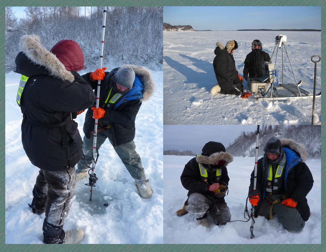
Discharge measurements through ice: 15292780 Susitna River at Sunshine, AK; Matt Chilson and Gary Johnson; Robert Mason, January 2012 (left and bottom right) | 15565447 Yukon River at Pilot Station, AK;
Charles Couvillion and Mark Spindler; Josh Morse, January 2012 (top right)
Isaac Newton b 1643
Clarence King b 1842
Daniel Bernoulli b 1700
StreamStatshttp://streamstats.usgs.gov/
U.S. Geological Survey http://www.usgs.govTelephone: 1-888-ASK-USGS
Martin Luther King Day
Inauguration Day (obs)
Aldo Leopold b 1887
DecemberS
2 9162330
M
310172431
T
4111825
W
5121926
T 6
132027
F 7
142128
S1
8152229
FebruaryS
3101724
M
4 111825
T
5121926
W 6
132027
T 7
142128
F1
81522
S2
91623
Notes:
Reversal of the Chicago River 1900
30 31
Inauguration Day
HappyNew Year2013
HappyNew Year2013


SUNDAY MONDAY TUESDAY WEDNESDAY THURSDAY FRIDAY SATURDAY
February 2013
1 2
3 4 5 6 7 8 9
10 11 12 13 14 15 16
17 18 19 20 21
24 25
22 23
26
Discharge measurement with tractor rig: 06360500 Moreau River near Whitehorse, SD; Craig Solberg and Joel Petersen; Bruce Venner, March 2011
Groundhog Day
Valentine’s Day
Purim
Flood Inundation Mapping Sciencehttp://water.usgs.gov/osw/flood_inundation/
U.S. Geological Survey http://www.usgs.govTelephone: 1-888-ASK-USGS
Mardi GrasAbraham Lincoln b 1809
George Washingtonb 1732
JanuaryS
6132027
M
7142128
T 1
8152229
W29
162330
T3
10172431
F4
111825
S5
121926
MarchS
310172431
M
4 111825
T
5121926
W 6
132027
T 7
142128
F1
8152229
S2
9162330
Lunar New YearCL Navier b 1785
Notes:
Galileo Galilei b 1564
27 28
President’s Day
Ash Wednesday
e DaySuper BowlSuper Bowl
SUNDAY MONDAY TUESDAY WEDNESDAY THURSDAY FRIDAY SATURDAY
March 2013
1 2
3 4 5 6 7 8 9
10 11 12 13 14 15 16
17 18 19 20 21
24 25
22 23
26
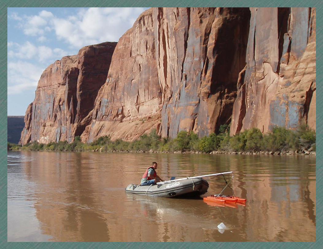
Discharge measurement using an Acoustic Doppler Current Profiler (ADCP): Colorado River near Moab, UT; Jay Cederberg; Steve Gerner, October 2010
Read Across America DayTheodor Seuss Geisel b 1904
USGS Established 1879
World MeteorologicalDay
Water Data Discoveryhttp://water.usgs.gov/data/
U.S. Geological Survey http://www.usgs.govTelephone: 1-888-ASK-USGS
First Day of Passover
Vernal Equinox
February
S
3101724
M
4 111825
T
5121926
W 6
132027
T 7
142128
F1
81522
S2
91623
Daylight Saving Time Starts
Notes:
Good Friday
27 28
Palm SundayJohn Wesley Powell b 1834
EasterRene Descartes b 1596
CW Thornthwaiteb 1899
31
29 30
Frederick H Newell b 1862
Magnitide 9.0 Earthquakenear East Coast of Honshu, Japan 2011
pi DayAlbert Einstein b 1879
St. Patrick’s Day World Water Day
Magnitude 9.2Great Alaska Earthquake 1964
April
S
7142128
M 1
8152229
T 2
9162330
W3
101724
T4
111825
F5
121926
S6
132027
31
UN
ITED S
TTA
E S
YE
VR
USLACIG
OLO
GE


SUNDAY MONDAY TUESDAY WEDNESDAY THURSDAY FRIDAY SATURDAY
April 2013
5 6
7 8 9 10 11 12 13
14 15 16 17 18 19 20
21 22 23 24 25
28 29
26 27
30
09499000 Tonto Creek above Gun Creek near Roosevelt, AZ; Bert Duet, December 2011
William Henry Jacksonb 1843April Fool’s Day
National Water Information Systemhttp://waterdata.usgs.gov/nwis/
U.S. Geological Survey http://www.usgs.govTelephone: 1-888-ASK-USGS
Administrative Professionals Day
MarchS
310172431
M
4 111825
T
5121926
W 6
132027
T 7
142128
F1
8152229
S2
9162330
Notes:
World Day for Safety and Health at Work
Howard Penmanb 1909
Tax DayLeonardo da Vincib 1452
Earth DayJLM Poiseuille b 1797John Muir b 1838 Arbor Day
MayS
5121926
M 6
132027
T 7
142128
W1
8152229
T2
9162330
F3
10172431
S4
111825
1 2 3 4
Earth Day


SUNDAY MONDAY TUESDAY WEDNESDAY THURSDAY FRIDAY SATURDAY
May 2013
3 4
5 6 7 8 9 10 11
12 13 14 15 16 17 18
19 20 21 22 23
26 27
24 25
28
10342900 Independence Lake near Truckee, CA; Jesse Juchtzer, June 2011
Henry Pitot b 1695
WaterWatchhttp://waterwatch.usgs.gov/
U.S. Geological Survey http://www.usgs.govTelephone: 1-888-ASK-USGS
Armed Forces DayRobert E Horton b 1875Mount St HelensErupted 1980
AprilS
7142128
M 1
8 152229
T29
162330
W3
101724
T4
111825
F5
121926
S6
132027
Notes:
Louis Agassiz b 1807
Mother’s DayFlorence Nightingaleb 1820
International Day forBiological Diversity
Hans A Einstein b 1904
Memorial DayRachel Carson b 1907
JuneS
2 9162330
M 3
101724
T 4
111825
W
5121926
T
6132027
F
7142128
S 1 8152229
1 2
29 30 31
Johnstown Flood1889
12
Mother’s Day


SUNDAY MONDAY TUESDAY WEDNESDAY THURSDAY FRIDAY SATURDAY
June 2013
1
2 3 4 5 6 7 8
9 10 11 12 13 14 15
16 17 18 19 20
23 24
21 22
25
Willimantic River near Coventry, CT; installing temperature probes to quantify groundwater/surface water interaction; Emily Voytek; Sean Buckley, June 2012 (top left) | Massachusetts Military Reservation, Falmouth, MA; installing multi-method sampling probes to monitor infiltration rates;
Emily Voytek/Denis LeBlanc; John Lane, May 2012 (top center) | Delaware River at Callicoon, NY; installing groundwater monitoring wells;Emily Voytek; Martin Briggs, June 2012 (top right) | 254625080290801 G-3928; drilling borehole; Jeff Robinson October 2009 (bottom)
World Environment Day
WaterAlerthttp://water.usgs.gov/wateralert/
U.S. Geological Survey http://www.usgs.govTelephone: 1-888-ASK-USGS
Day of the Seafarer
Blaise Pascal b 1623
May
S
5121926
M
6 132027
T
7142128
W18
152229
T29
162330
F3
10172431
S4
111825
World Day to CombatDesertification and Drought
Notes:
26 27
Public Service Day
World Oceans Day
30
28 29
Henry Darcy b 1803Abel Wolman b 1892
Flag Day
World Blood Donor Day
Father’s Day Summer Solstice
July
S
7142128
M 1
8152229
T 2
9162330
W3
10172431
T4
111825
F5
121926
S6
132027

SUNDAY MONDAY TUESDAY WEDNESDAY THURSDAY FRIDAY SATURDAY
July 2013
5 6
7 8 9 10 11 12 13
14 15 16 17 18 19 20
21 22 23 24 25
28 29
26 27
30
11414210 South Yuba River Controlled Release at Lake Spaulding, near Emigrant Gap, CA; Jesse Juchtzer, July 2011
Independence Day Gotfried Leibniz b 1646Canada Day
StreamStatshttp://streamstats.usgs.gov/
U.S. Geological Survey http://www.usgs.govTelephone: 1-888-ASK-USGS
Big Thompson Flood 1976(31,200 cfs)
JuneS
2 9162330
M
3101724
T
4111825
W 5
121926
T 6
132027
F
7142128
S1
8152229
Notes:
pi Approximation Day
AugustS
4111825
M 5
121926
T 6
132027
W
7142128
T1
8152229
F2
9162330
S3
10172431
1 2 3 4
31
Ramadan Begins


SUNDAY MONDAY TUESDAY WEDNESDAY THURSDAY FRIDAY SATURDAY
August 2013
2 3
4 5 6 7 8 9 10
11 12 13 14 15 16 17
18 19 20 21 22
25 26
23 24
27
Sampling Suspended sediment: 14243000 Cowlitz River at Castle Rock, WA; Chris Curran, Raegan Huffman, and Mark Landers―Lisst SL laser diffraction analyzer on left and P-61 (top left) and D74 Sampler (bottom left); Kurt Spicer, March 2012/November 2011
14123500 White Salmon River near Underwood, WA; Breaching of Condit Dam produced mudflow at downstream gage, suspended dip samples were collected the day of the breach after samplers clogged; Adam Mosbrucker, October 2011 (right)
Peak of Record Mississippi River at St. Louis (1,070,000 cfs) 1993
Amadeo Avogadro b 1776
Flood Inundation Mapping Sciencehttp://water.usgs.gov/osw/flood_inundation/
U.S. Geological Survey http://www.usgs.govTelephone: 1-888-ASK-USGS
Hurricane Andrew 1992
JulyS
7142128
M 1
8152229
T29
162330
W 310172431
T4
111825
F5
12 19 26
S6
13 2027
Notes:
SeptemberS
18
152229
M 2
9162330
T 3101724
W4
11 1825
T5
121926
F6
132027
S7
142128
1
28
Eid al-Fitr
29 30 31
Julius Weisbach b 1806
George Stokes b 1819
Harold A Thomas b 1913Ven Te Chow b 1919
Gordon “Reds” Wolman b 1924
Hurricane Camille 1969Pierre de Fermat b 1601
Barre de Saint Venant b 1797Osborne Reynolds b 1842
The Great ColonialFlood 1635 Hurricane Katrina 2005


SUNDAY MONDAY TUESDAY WEDNESDAY THURSDAY FRIDAY SATURDAY
September 2013
6 7
8 9 10 11 12 13 14
15 16 17 18 19 20 21
22 23 24 25 26
29 30
27 28
13039500 Henrys Fork near Lake, ID; Jake Jacobson, September 2008
Rosh HashanahLabor Day
Water Data Discoveryhttp://water.usgs.gov/data/
U.S. Geological Survey http://www.usgs.govTelephone: 1-888-ASK-USGS
Yom Kippur
AugustS
4111825
M 5
121926
T
6132027
W
7142128
T1
8152229
F2
9 162330
S3
10172431
Notes:
Grandparent’s Day
International Literacy Day
Galveston Hurricane 1900
OctoberS
6132027
M 7
142128
T 1
8152229
W2
9162330
T3
10172431
F4
111825
S5
121926
2 3 4 5
Carl Garner Federal Lands Cleanup Day
1
Autumn Equinox
World Water Monitoring Day World Maritime Day
Patriot Day
San Felipe-Okeechobee Hurricane 1928
Hurricane Ike 2008
International Day for the Preservation of the Ozone Layer
International Talk Like a Pirate Day
Hurricane Rita 2005


SUNDAY MONDAY TUESDAY WEDNESDAY THURSDAY FRIDAY SATURDAY
October 2013
1 2 3 4 5
6 7 8 9 10 11 12
13 14 15 16 17 18 19
20 21 22 23 24
27 28
25 26
29
Collecting algae samples: Boise River at Barber Park east of Boise, ID; Traci Hoff/Marshall Williams; Tim Merrick, October 2011 (top left)Bed sediment sampling: 02344797 White Oak Creek at Cannon Road near Raymond, GA; Dan Calhoun; Alan Cressler, May 2011 (top right)
Water quality sampling with DH-81: 02335870 Sope Creek near Marietta, GA; Dan Calhoun/Jeff Riley; Alan Cressler, October 2009 (bottom)
Luna Leopold b 1915
Robert Manning b 1816
National Water Information Systemhttp://waterdata.usgs.gov/nwis/
U.S. Geological Survey http://www.usgs.govTelephone: 1-888-ASK-USGS
JR Mather b 1923
International Day for Natural Disaster Reduction
Leif Erikson Day
Walter Langbein b 1907
September
S 1
8152229
M 2
9162330
T 3101724
W4
111825
T5
121926
F6
132027
S7
142128
November
S
3101724
M
4 111825
T
5121926
W 6
132027
T 7
142128
F1
8152229
S2
9162330
Notes:
World Habitat Day
30 31
Columbus Day
Thanksgiving Day (Canada)Eid al-AdhaE Torricelli b 1608 Boss’s Day
World Teacher’s Day
Mole Day


SUNDAY MONDAY TUESDAY WEDNESDAY THURSDAY FRIDAY SATURDAY
November 2013
1 2
3 4 5 6 7 8 9
10 11 12 13 14 15 16
17 18 19 20 21
24 25
22 23
26
15302200 Koktuli River near Iliamna, AK; Johnse Ostman at gage; Charles Couvillion, October 2011
World Science Day
Election Day
WaterWatchhttp://waterwatch.usgs.gov/
U.S. Geological Survey http://www.usgs.govTelephone: 1-888-ASK-USGS
October
S
6132027
M
7 142128
T18
152229
W29
162330
T3
10172431
F4
111825
S5
121926
Daylight Saving Time Ends
Notes:
27 28
Louis Daguerre b 1851
Hedy Lemarr b 1913Marie Currie b 1867
29 30
Edmond Halley b 1656
Veterans DayCarleton Watkins b 1829
Universal Children’s Day
Thanksgiving DayHanukkah
December
S 1
8152229
M 2
9162330
T 310172431
W4
111825
T5
121926
F6
132027
S7
142128
Gilbert F. White b 1911


SUNDAY MONDAY TUESDAY WEDNESDAY THURSDAY FRIDAY SATURDAY
December 2013
6 7
8 9 10 11 12 13 14
15 16 17 18 19 20 21
22 23 24 25 26
29 30
27 28
James Akins hiking in to inspect gage; 11502500 Williamson River below Sprague River near Chiloquin, OR; Mark Schuster, March 2012
Kwanza
9.1 Earthquake and Tsunami, Off the WestCoast of NorthernSumatra, 2004
International Mountain Day
WaterAlerthttp://water.usgs.gov/wateralert/
U.S. Geological Survey http://www.usgs.govTelephone: 1-888-ASK-USGS
New Year’s Eve
NovemberS
3101724
M 4
111825
T
5121926
W
6132027
T
7142128
F1
8 152229
S2
9162330
Notes:
First official USGS discharge measurement,Embudo, NM 1888
January 2014S
5121926
M 6
132027
T 7
142128
W1
8152229
T2
9162330
F3
10172431
S4
111825
2 3 4 5
Christmas Eve
1
Ellen S Richards b 1842International Volunteer Day
Winter Solstice
31
Grace Hopper b 1906 Ada Lovelace b 1815
Charles Babbage b 1791

March
FebruaryJanuary
April
May June
July August
November
OctoberSeptember
December
2014
S
6132027
M
7142128
T18
152229
W29
162330
T3
101724
F4
111825
S5
121926
S
4111825
M
5121926
T
6132027
W
7142128
T 18
152229
F29
162330
S3
10172431
S
6132027
M
7142128
T18
152229
W29
162330
T3
10172431
F4
111825
S5
121926
S
7142128
M18
152229
T29
162330
W3
101724
T4
111825
F5
121926
S6
132027
S
7142128
M18
152229
T29
162330
W3
10172431
T4
111825
F5
121926
S6
132027
S 18
152229
M29
162330
T3
101724
W4
111825
T5
121926
F6
132027
S7
142128
S
310172431
M
4111825
T
5121926
W
6132027
T
7142128
F18
152229
S29
162330
S
5121926
M
6132027
T
7142128
W 18
152229
T 29
162330
F3
10172431
S4
111825
S
29
1623
M
3101724
T
4111825
W
5121926
T
6132027
F
7142128
S18
1522
S
29
162330
M
310172431
T
4111825
W
5121926
T
6132027
F
7142128
S18
152229
S
5121926
M
6132027
T
7142128
W 18
152229
T 29
162330
F3
10172431
S4
111825
S
29
162330
M
3101724
T
4111825
W
5121926
T
6132027
F
7142128
S18
152229
Paul Ankorn making a discharge measurement. Civilian Conservation Corps gagehouse in background.
02177000 Chattooga River near Clayton, GA; Alan Cressler, February 2012

Streamgages in cooperation with: JANUARY: 15565447―National Streamflow Information Program; 15292780―Alaska Energy Authority FEBRUARY: 06360500―U.S. Army Corps of Engineers MARCH: Colorado River Basin Salinity Control Forum APRIL: 09499000―Salt River Valley Water Users’ Association, Arizona Department of Water Resources MAY: 10342900―Truckee Meadows Water Authority for Water Resource Mgmt JUNE: USGS Groundwater Resources Program; Air Force Center for Engineering and the Environment and USGS Toxic Substances Hydrology Program; U.S. Fish and Wildlife Service and USGS Groundwater Resources Program; U.S. Army Corps of Engineers JULY: 11414210―Pacific Gas and Electric Company/Federal Energy Reglatory Commission AUGUST: 14123500/14243000―Bonneville Power Administration; Tacoma Public Utilities and National Streamflow Information Program SEPTEMBER: 13039500―Water District No. 1 OCTOBER: 02344797/02335870―Lower Boise Watershed Council; Georgia Department of Agriculture; Atlanta Regional Commission NOVEMBER: 15302200―Alaska Department of Fish and Game DECEMBER: 11502500―PacifiCorp and the Klamath Tribes 2014: 02177000―Georgia Department of Natural Resources/Environmental Protection Division
Popular USGS Water Resources Websites StreamStats—streamstats.usgs.gov/ National Streamflow Statistics—water.usgs.gov/osw/programs/nss National Water Quality Assessment—water.usgs.gov/nawqa Cooperative Water—water.usgs.gov/coop National Research—water.usgs.gov/nrp National Streamflow Information Program (NSIP)—water.usgs.gov/nsip Water Data Discovery—water.usgs.gov/data Groundwater—water.usgs.gov/ogw Surface Water—water.usgs.gov/osw Water Quality—water.usgs.gov/owq USGS Water Science Centers—water.usgs.gov/local_offices.html WaterWatch—waterwatch.usgs.gov National Water Information System—waterdata.usgs.gov/nwis Instantaneous Streamflow Data Archive (IDA)—ida.water.usgs.gov/ida Water Use Information—water.usgs.gov/watuse Water Availability—water.usgs.gov/ogw/gwrp/activities/water-avail-use.html
Educational Resources Water Science for Schools—ga.water.usgs.gov/edu USGS and Science Education—education.usgs.gov Information for Students and Teachers—water.usgs.gov/education.html
Publications and Products Annual Water Data Reports—wdr.water.usgs.gov USGS Publications Warehouse—pubs.er.usgs.gov Software Models and Tools—water.usgs.gov/software
Lower Mississippi River Basin; Imagesshow cohesive soilplumes formed bythe Bonnett CarreSpillway into Lake Pontchartrain, mouth of the Atchafalaya River, and the Bird’s Foot Delta Region at themouth of the Mississippi River. True color (top), May 17, 2011 andcolor enhanced to highlight areas of sediment discharge (bottom), May 15, 2011; NASAModerate Resol-ution ImagingSpectroradiometer(MODIS).
Note: Use or display of brand names does not imply endorsement.For some religious holidays, observance begins at sunset of the day before.

What’s happening with the water?
Is the stream flooding? (Above a threshold)
Sign-up for threshold-triggered daily or hourly emailor text notices about current water conditions: http://water.usgs.gov/wateralert/
Is the water too shallow or the dissolved oxygen too low? (Below a threshold)
Is the water just where you like it? (Between thresholds)
WaterAlert
Kevi
n W
righ
t, C
O W
SCJe
rrod
Whe
eler
, WY
WSC
Nic
k St
asul
is, M
E W
SC
WaterAlert
USGS WaterAlertSubscription Form
Site Info:
Greater than (>)Less than (<)Outside a range (< or>)Inside a range (> and <)
Real-time value is greater than: ft
Discharge (cfs)Gage height (ft)
HourlyDaily
My mobile phoneMy email address
Site Number:Site Name:
Agency:Transaction ID:
07288280BIG SUNFLOWER RIVER NR MERIGOLD, MSUSGStT8sq
Recent value:44 [peak chart]
4.17 [peak chart]
Send Notification To: about this...
Notification Frequency: about this...
about this...Streamflow Data-type Parameter:
about this...Threshold Condition: