Embed Size (px)
Citation preview

Portland State University Portland State University
PDXScholar PDXScholar
Geography Faculty Publications and Presentations Geography
8-1-1998
Water Flow through Temperate Glaciers Water Flow through Temperate Glaciers
Andrew G. Fountain Portland State University
Joseph S. Walder
Follow this and additional works at: https://pdxscholar.library.pdx.edu/geog_fac
Part of the Environmental Sciences Commons
Let us know how access to this document benefits you.
Citation Details Citation Details Fountain, Andrew G., and Joseph S. Walder. "Water flow through temperate glaciers." Reviews of Geophysics 36.3 (1998): 299-328.
This Article is brought to you for free and open access. It has been accepted for inclusion in Geography Faculty Publications and Presentations by an authorized administrator of PDXScholar. Please contact us if we can make this document more accessible: [email protected].
WATER FLOW THROUGH TEMPERATE GLACIERS
Andrew G. Fountain1
Department of GeologyPortland State UniversityPortland, Oregon
Joseph S. WalderU.S. Geological SurveyCascades Volcano ObservatoryVancouver, Washington
Abstract. Understanding water movement through aglacier is fundamental to several critical issues in glaci-ology, including glacier dynamics, glacier-inducedfloods, and the prediction of runoff from glacierizeddrainage basins. To this end we have synthesized aconceptual model of water movement through a temper-ate glacier from the surface to the outlet stream. Pro-cesses that regulate the rate and distribution of waterinput at the glacier surface and that regulate watermovement from the surface to the bed play importantbut commonly neglected roles in glacier hydrology.Where a glacier is covered by a layer of porous, perme-able firn (the accumulation zone), the flux of water tothe glacier interior varies slowly because the firn tempo-rarily stores water and thereby smooths out variations inthe supply rate. In the firn-free ablation zone, in con-trast, the flux of water into the glacier depends directlyon the rate of surface melt or rainfall and thereforevaries greatly in time. Water moves from the surface tothe bed through an upward branching arborescent net-work consisting of both steeply inclined conduits,formed by the enlargement of intergranular veins, andgently inclined conduits, spawned by water flow alongthe bottoms of near-surface fractures (crevasses). Engla-cial drainage conduits deliver water to the glacier bed ata limited number of points, probably a long distancedownglacier of where water enters the glacier. Englacialconduits supplied from the accumulation zone are quasisteady state features that convey the slowly varying waterflux delivered via the firn. Their size adjusts so that they
are usually full of water and flow is pressurized. Incontrast, water flow in englacial conduits supplied fromthe ablation area is pressurized only near times of peakdaily flow or during rainstorms; flow is otherwise in anopen-channel configuration. The subglacial drainagesystem typically consists of several elements that aredistinct both morphologically and hydrologically. An up-glacier branching, arborescent network of channels in-cised into the basal ice conveys water rapidly. Much ofthe water flux to the bed probably enters directly into thearborescent channel network, which covers only a smallfraction of the glacier bed. More extensive spatially is anonarborescent network, which commonly includes cav-ities (gaps between the glacier sole and bed), channelsincised into the bed, and a layer of permeable sediment.The nonarborescent network conveys water slowly and isusually poorly connected to the arborescent system. Thearborescent channel network largely collapses duringwinter but reforms in the spring as the first flush ofmeltwater to the bed destabilizes the cavities within thenonarborescent network. The volume of water stored bya glacier varies diurnally and seasonally. Small, temper-ate alpine glaciers seem to attain a maximum seasonalwater storage of ;200 mm of water averaged over thearea of the glacier bed, with daily fluctuations of as muchas 20–30 mm. The likely storage capacity of subglacialcavities is insufficient to account for estimated storedwater volumes, so most water storage may actually occurenglacially. Stored water may also be released abruptlyand catastrophically in the form of outburst floods.
1. INTRODUCTION
The movement of water through glaciers is importantfor scientific understanding and for immediate practicalapplications. Water in glaciers profoundly affects glaciermovement by influencing the stress distribution at theglacier bed and thereby the rate at which the ice slidesover the bed. This process is important for both alpineglaciers [e.g., Iken and Bindschadler, 1986] and polar icestreams [e.g., Alley et al., 1987; Echelmeyer and Harrison,1990; Kamb, 1991]. The episodic surging (orders-of-magnitude increase in speed) of some glaciers is evi-
dently due to temporal changes in subglacial hydrology[Kamb et al., 1985]. Glacial outburst floods, a commonhazard in mountainous regions, result from the rapidrelease of large volumes of water stored either within aglacier or in a glacier-dammed lake [Bjornsson, 1992;Haeberli, 1983; Walder and Costa, 1996]. Water fromglaciers is becoming increasingly important for hydro-electric power generation [Benson et al., 1986; Lang andDyer, 1985]. Some hydropower projects in France [Hantzand Lliboutry, 1983], Norway [Hooke et al., 1984], andSwitzerland [Bezinge, 1981] have involved tapping waterfrom directly beneath a glacier.
The purpose of this paper is to present a conceptualmodel of water flow through a glacier based on a syn-1Formerly at U.S. Geological Survey, Denver, Colorado.
Copyright 1998 by the American Geophysical Union. Reviews of Geophysics, 36, 3 / August 1998pages 299–328
8755-1209/98/97RG-03579$15.00 Paper number 97RG03579● 299 ●
thesis of our current understanding. We have extendedthe scope of previous reviews [Rothlisberger and Lang,1987; Lawson, 1993] by focusing on ways in which thevarious components of the drainage system interact. Aspart of the conclusions, we outline subjects that needfurther investigation. This paper emphasizes temperatealpine glaciers (glaciers at their melting point), but re-sults from and implications for ice sheets are includedwhere appropriate. We do not discuss the hydrologicalrole of the seasonal snowpack, as there is a comparativewealth of literature on the subject [e.g., Male and Gray,1981; Bales and Harrington, 1995] and because the effectof snow on glacier hydrology has recently been reviewed[Fountain, 1996].
2. HYDROLOGY OF THE FIRNAND NEAR-SURFACE ICE
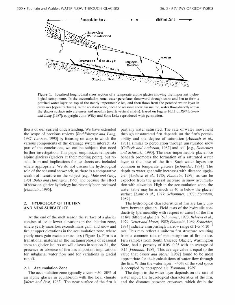
At the end of the melt season the surface of a glacierconsists of ice at lower elevations in the ablation zone,where yearly mass loss exceeds mass gain, and snow andfirn at upper elevations in the accumulation zone, whereyearly mass gain exceeds mass loss (Figure 1). Firn is atransitional material in the metamorphosis of seasonalsnow to glacier ice. As we will discuss in section 2.1, thepresence or absence of firn has important implicationsfor subglacial water flow and for variations in glacialrunoff.
2.1. Accumulation ZoneThe accumulation zone typically covers ;50–80% of
an alpine glacier in equilibrium with the local climate[Meier and Post, 1962]. The near surface of the firn is
partially water saturated. The rate of water movementthrough unsaturated firn depends on the firn’s perme-ability and the degree of saturation [Ambach et al.,1981], similar to percolation through unsaturated snow[Colbeck and Anderson, 1982] and soil [e.g., Domenicoand Schwartz, 1990]. The near-impermeable glacier icebeneath promotes the formation of a saturated waterlayer at the base of the firn. Such water layers arecommon in temperate glaciers [Schneider, 1994]. Thedepth to water generally increases with distance upgla-cier [Ambach et al., 1978; Fountain, 1989], as can beexpected from the general increase in snow accumula-tion with elevation. High in the accumulation zone, thewater table may be as much as 40 m below the glaciersurface [Lang et al., 1977; Schommer, 1977; Fountain,1989].
The hydrological characteristics of firn are fairly uni-form between glaciers. Field tests of the hydraulic con-ductivity (permeability with respect to water) of the firnat five different glaciers [Schommer, 1978; Behrens et al.,1979; Oerter and Moser, 1982; Fountain, 1989; Schneider,1994] indicate a surprisingly narrow range of 1–5 3 1025
m/s. This may reflect a uniform firn structure resultingfrom a common rate of metamorphism of firn to ice.Firn samples from South Cascade Glacier, WashingtonState, had a porosity of 0.08–0.25 with an average of0.15 [Fountain, 1989]. This average value is equal to thevalue that Oerter and Moser [1982] found to be mostappropriate for their calculations of water flow throughthe firn. Within the water layer, ;40% of the void spaceis occupied by entrapped air [Fountain, 1989].
The depth to the water layer depends on the rate ofwater input, the hydrological characteristics of the firn,and the distance between crevasses, which drain the
Figure 1. Idealized longitudinal cross section of a temperate alpine glacier showing the important hydro-logical components. In the accumulation zone, water percolates downward through snow and firn to form aperched water layer on top of the nearly impermeable ice, and then flows from the perched water layer increvasses (open fractures). In the ablation zone, once the seasonal snow has melted, water flows directly acrossthe glacier surface into crevasses and moulins (nearly vertical shafts). Based on Figure 10.11 of Rothlisbergerand Lang [1987]; copyright John Wiley and Sons Ltd.; reproduced with permission.
300 ● Fountain and Walder: WATER FLOW THROUGH GLACIERS 36, 3 / REVIEWS OF GEOPHYSICS
water from the firn [Lang et al., 1977; Schommer, 1977;Fountain, 1989]. Over small areas (length scales of ;102
m) of a glacier both surface melt rate and firn perme-ability are relatively uniform, and the depth to water iscontrolled primarily by crevasse spacing. Water input tothe firn varies both seasonally and daily. Seasonal vari-ations, ranging from no water input in winter to perhapsas much as several tens of millimeters per day in sum-mer, cause the thickness of the water layer to vary up toseveral meters [Lang et al., 1977; Schommer, 1977, 1978;Oerter and Moser, 1982]. Typically, the water table re-sponds to melt and precipitation within a day or two[Oerter and Moser, 1982; Schommer, 1977; Schneider,1994], although diurnal variations have been occasion-ally observed [e.g., Fountain, 1989].
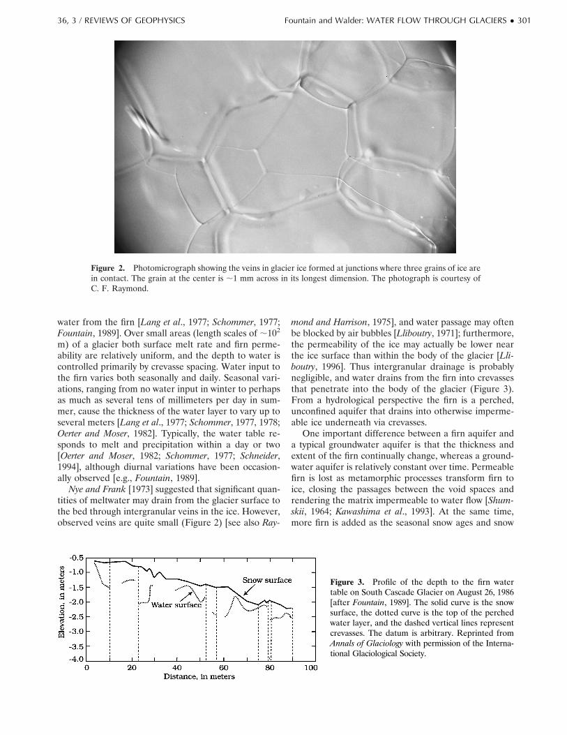
Nye and Frank [1973] suggested that significant quan-tities of meltwater may drain from the glacier surface tothe bed through intergranular veins in the ice. However,observed veins are quite small (Figure 2) [see also Ray-
mond and Harrison, 1975], and water passage may oftenbe blocked by air bubbles [Lliboutry, 1971]; furthermore,the permeability of the ice may actually be lower nearthe ice surface than within the body of the glacier [Lli-boutry, 1996]. Thus intergranular drainage is probablynegligible, and water drains from the firn into crevassesthat penetrate into the body of the glacier (Figure 3).From a hydrological perspective the firn is a perched,unconfined aquifer that drains into otherwise imperme-able ice underneath via crevasses.
One important difference between a firn aquifer anda typical groundwater aquifer is that the thickness andextent of the firn continually change, whereas a ground-water aquifer is relatively constant over time. Permeablefirn is lost as metamorphic processes transform firn toice, closing the passages between the void spaces andrendering the matrix impermeable to water flow [Shum-skii, 1964; Kawashima et al., 1993]. At the same time,more firn is added as the seasonal snow ages and snow
Figure 2. Photomicrograph showing the veins in glacier ice formed at junctions where three grains of ice arein contact. The grain at the center is ;1 mm across in its longest dimension. The photograph is courtesy ofC. F. Raymond.
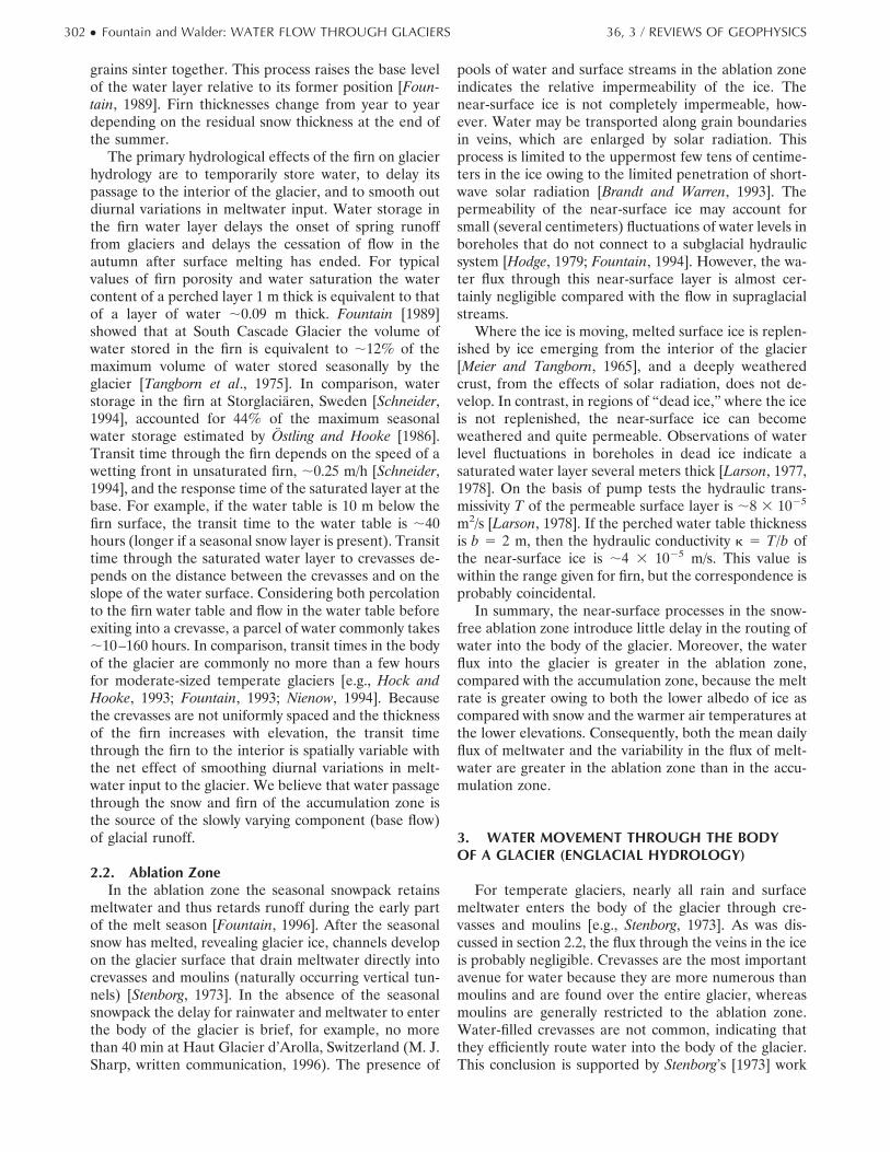
Figure 3. Profile of the depth to the firn watertable on South Cascade Glacier on August 26, 1986[after Fountain, 1989]. The solid curve is the snowsurface, the dotted curve is the top of the perchedwater layer, and the dashed vertical lines representcrevasses. The datum is arbitrary. Reprinted fromAnnals of Glaciology with permission of the Interna-tional Glaciological Society.
36, 3 / REVIEWS OF GEOPHYSICS Fountain and Walder: WATER FLOW THROUGH GLACIERS ● 301
grains sinter together. This process raises the base levelof the water layer relative to its former position [Foun-tain, 1989]. Firn thicknesses change from year to yeardepending on the residual snow thickness at the end ofthe summer.
The primary hydrological effects of the firn on glacierhydrology are to temporarily store water, to delay itspassage to the interior of the glacier, and to smooth outdiurnal variations in meltwater input. Water storage inthe firn water layer delays the onset of spring runofffrom glaciers and delays the cessation of flow in theautumn after surface melting has ended. For typicalvalues of firn porosity and water saturation the watercontent of a perched layer 1 m thick is equivalent to thatof a layer of water ;0.09 m thick. Fountain [1989]showed that at South Cascade Glacier the volume ofwater stored in the firn is equivalent to ;12% of themaximum volume of water stored seasonally by theglacier [Tangborn et al., 1975]. In comparison, waterstorage in the firn at Storglaciaren, Sweden [Schneider,1994], accounted for 44% of the maximum seasonalwater storage estimated by Ostling and Hooke [1986].Transit time through the firn depends on the speed of awetting front in unsaturated firn, ;0.25 m/h [Schneider,1994], and the response time of the saturated layer at thebase. For example, if the water table is 10 m below thefirn surface, the transit time to the water table is ;40hours (longer if a seasonal snow layer is present). Transittime through the saturated water layer to crevasses de-pends on the distance between the crevasses and on theslope of the water surface. Considering both percolationto the firn water table and flow in the water table beforeexiting into a crevasse, a parcel of water commonly takes;10–160 hours. In comparison, transit times in the bodyof the glacier are commonly no more than a few hoursfor moderate-sized temperate glaciers [e.g., Hock andHooke, 1993; Fountain, 1993; Nienow, 1994]. Becausethe crevasses are not uniformly spaced and the thicknessof the firn increases with elevation, the transit timethrough the firn to the interior is spatially variable withthe net effect of smoothing diurnal variations in melt-water input to the glacier. We believe that water passagethrough the snow and firn of the accumulation zone isthe source of the slowly varying component (base flow)of glacial runoff.
2.2. Ablation ZoneIn the ablation zone the seasonal snowpack retains
meltwater and thus retards runoff during the early partof the melt season [Fountain, 1996]. After the seasonalsnow has melted, revealing glacier ice, channels developon the glacier surface that drain meltwater directly intocrevasses and moulins (naturally occurring vertical tun-nels) [Stenborg, 1973]. In the absence of the seasonalsnowpack the delay for rainwater and meltwater to enterthe body of the glacier is brief, for example, no morethan 40 min at Haut Glacier d’Arolla, Switzerland (M. J.Sharp, written communication, 1996). The presence of
pools of water and surface streams in the ablation zoneindicates the relative impermeability of the ice. Thenear-surface ice is not completely impermeable, how-ever. Water may be transported along grain boundariesin veins, which are enlarged by solar radiation. Thisprocess is limited to the uppermost few tens of centime-ters in the ice owing to the limited penetration of short-wave solar radiation [Brandt and Warren, 1993]. Thepermeability of the near-surface ice may account forsmall (several centimeters) fluctuations of water levels inboreholes that do not connect to a subglacial hydraulicsystem [Hodge, 1979; Fountain, 1994]. However, the wa-ter flux through this near-surface layer is almost cer-tainly negligible compared with the flow in supraglacialstreams.
Where the ice is moving, melted surface ice is replen-ished by ice emerging from the interior of the glacier[Meier and Tangborn, 1965], and a deeply weatheredcrust, from the effects of solar radiation, does not de-velop. In contrast, in regions of “dead ice,” where the iceis not replenished, the near-surface ice can becomeweathered and quite permeable. Observations of waterlevel fluctuations in boreholes in dead ice indicate asaturated water layer several meters thick [Larson, 1977,1978]. On the basis of pump tests the hydraulic trans-missivity T of the permeable surface layer is ;8 3 1025
m2/s [Larson, 1978]. If the perched water table thicknessis b 5 2 m, then the hydraulic conductivity k 5 T/b ofthe near-surface ice is ;4 3 1025 m/s. This value iswithin the range given for firn, but the correspondence isprobably coincidental.
In summary, the near-surface processes in the snow-free ablation zone introduce little delay in the routing ofwater into the body of the glacier. Moreover, the waterflux into the glacier is greater in the ablation zone,compared with the accumulation zone, because the meltrate is greater owing to both the lower albedo of ice ascompared with snow and the warmer air temperatures atthe lower elevations. Consequently, both the mean dailyflux of meltwater and the variability in the flux of melt-water are greater in the ablation zone than in the accu-mulation zone.
3. WATER MOVEMENT THROUGH THE BODYOF A GLACIER (ENGLACIAL HYDROLOGY)
For temperate glaciers, nearly all rain and surfacemeltwater enters the body of the glacier through cre-vasses and moulins [e.g., Stenborg, 1973]. As was dis-cussed in section 2.2, the flux through the veins in the iceis probably negligible. Crevasses are the most importantavenue for water because they are more numerous thanmoulins and are found over the entire glacier, whereasmoulins are generally restricted to the ablation zone.Water-filled crevasses are not common, indicating thatthey efficiently route water into the body of the glacier.This conclusion is supported by Stenborg’s [1973] work
302 ● Fountain and Walder: WATER FLOW THROUGH GLACIERS 36, 3 / REVIEWS OF GEOPHYSICS
showing that moulins develop from crevasses. Neitherthe nature of hydraulic links between crevasses and thebody of the glacier nor the formation of such links is wellunderstood. We attempt to address these topics below.
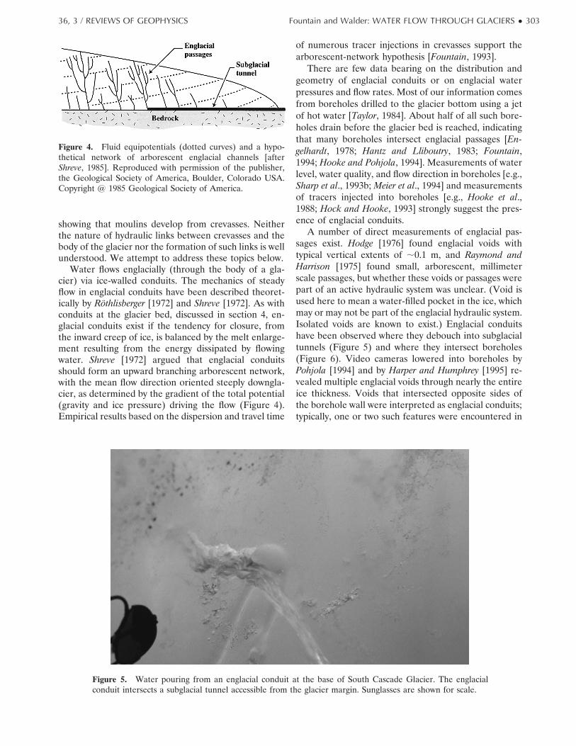
Water flows englacially (through the body of a gla-cier) via ice-walled conduits. The mechanics of steadyflow in englacial conduits have been described theoret-ically by Rothlisberger [1972] and Shreve [1972]. As withconduits at the glacier bed, discussed in section 4, en-glacial conduits exist if the tendency for closure, fromthe inward creep of ice, is balanced by the melt enlarge-ment resulting from the energy dissipated by flowingwater. Shreve [1972] argued that englacial conduitsshould form an upward branching arborescent network,with the mean flow direction oriented steeply downgla-cier, as determined by the gradient of the total potential(gravity and ice pressure) driving the flow (Figure 4).Empirical results based on the dispersion and travel time
of numerous tracer injections in crevasses support thearborescent-network hypothesis [Fountain, 1993].
There are few data bearing on the distribution andgeometry of englacial conduits or on englacial waterpressures and flow rates. Most of our information comesfrom boreholes drilled to the glacier bottom using a jetof hot water [Taylor, 1984]. About half of all such bore-holes drain before the glacier bed is reached, indicatingthat many boreholes intersect englacial passages [En-gelhardt, 1978; Hantz and Lliboutry, 1983; Fountain,1994; Hooke and Pohjola, 1994]. Measurements of waterlevel, water quality, and flow direction in boreholes [e.g.,Sharp et al., 1993b; Meier et al., 1994] and measurementsof tracers injected into boreholes [e.g., Hooke et al.,1988; Hock and Hooke, 1993] strongly suggest the pres-ence of englacial conduits.
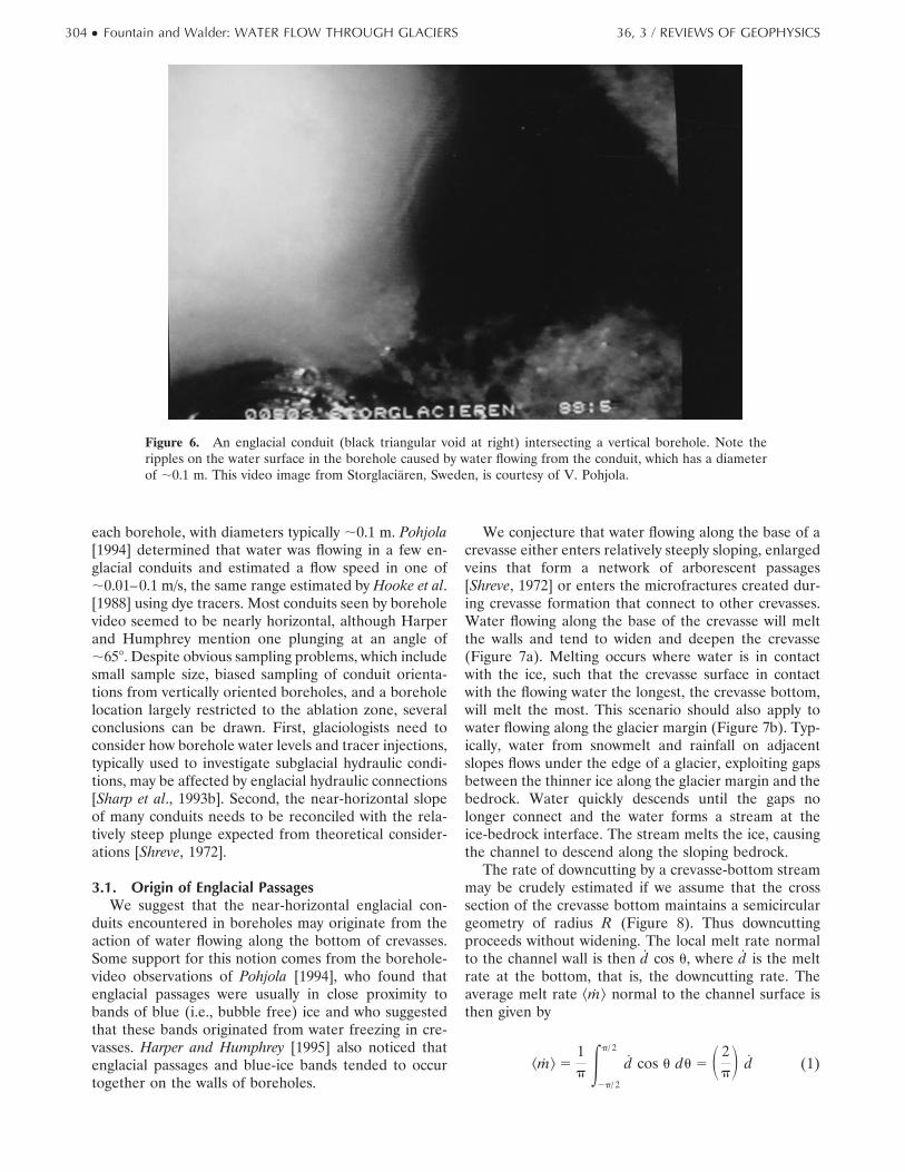
A number of direct measurements of englacial pas-sages exist. Hodge [1976] found englacial voids withtypical vertical extents of ;0.1 m, and Raymond andHarrison [1975] found small, arborescent, millimeterscale passages, but whether these voids or passages werepart of an active hydraulic system was unclear. (Void isused here to mean a water-filled pocket in the ice, whichmay or may not be part of the englacial hydraulic system.Isolated voids are known to exist.) Englacial conduitshave been observed where they debouch into subglacialtunnels (Figure 5) and where they intersect boreholes(Figure 6). Video cameras lowered into boreholes byPohjola [1994] and by Harper and Humphrey [1995] re-vealed multiple englacial voids through nearly the entireice thickness. Voids that intersected opposite sides ofthe borehole wall were interpreted as englacial conduits;typically, one or two such features were encountered in
Figure 4. Fluid equipotentials (dotted curves) and a hypo-thetical network of arborescent englacial channels [afterShreve, 1985]. Reproduced with permission of the publisher,the Geological Society of America, Boulder, Colorado USA.Copyright @ 1985 Geological Society of America.
Figure 5. Water pouring from an englacial conduit at the base of South Cascade Glacier. The englacialconduit intersects a subglacial tunnel accessible from the glacier margin. Sunglasses are shown for scale.
36, 3 / REVIEWS OF GEOPHYSICS Fountain and Walder: WATER FLOW THROUGH GLACIERS ● 303
each borehole, with diameters typically ;0.1 m. Pohjola[1994] determined that water was flowing in a few en-glacial conduits and estimated a flow speed in one of;0.01–0.1 m/s, the same range estimated by Hooke et al.[1988] using dye tracers. Most conduits seen by boreholevideo seemed to be nearly horizontal, although Harperand Humphrey mention one plunging at an angle of;658. Despite obvious sampling problems, which includesmall sample size, biased sampling of conduit orienta-tions from vertically oriented boreholes, and a boreholelocation largely restricted to the ablation zone, severalconclusions can be drawn. First, glaciologists need toconsider how borehole water levels and tracer injections,typically used to investigate subglacial hydraulic condi-tions, may be affected by englacial hydraulic connections[Sharp et al., 1993b]. Second, the near-horizontal slopeof many conduits needs to be reconciled with the rela-tively steep plunge expected from theoretical consider-ations [Shreve, 1972].
3.1. Origin of Englacial PassagesWe suggest that the near-horizontal englacial con-
duits encountered in boreholes may originate from theaction of water flowing along the bottom of crevasses.Some support for this notion comes from the borehole-video observations of Pohjola [1994], who found thatenglacial passages were usually in close proximity tobands of blue (i.e., bubble free) ice and who suggestedthat these bands originated from water freezing in cre-vasses. Harper and Humphrey [1995] also noticed thatenglacial passages and blue-ice bands tended to occurtogether on the walls of boreholes.
We conjecture that water flowing along the base of acrevasse either enters relatively steeply sloping, enlargedveins that form a network of arborescent passages[Shreve, 1972] or enters the microfractures created dur-ing crevasse formation that connect to other crevasses.Water flowing along the base of the crevasse will meltthe walls and tend to widen and deepen the crevasse(Figure 7a). Melting occurs where water is in contactwith the ice, such that the crevasse surface in contactwith the flowing water the longest, the crevasse bottom,will melt the most. This scenario should also apply towater flowing along the glacier margin (Figure 7b). Typ-ically, water from snowmelt and rainfall on adjacentslopes flows under the edge of a glacier, exploiting gapsbetween the thinner ice along the glacier margin and thebedrock. Water quickly descends until the gaps nolonger connect and the water forms a stream at theice-bedrock interface. The stream melts the ice, causingthe channel to descend along the sloping bedrock.
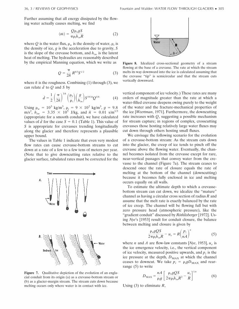
The rate of downcutting by a crevasse-bottom streammay be crudely estimated if we assume that the crosssection of the crevasse bottom maintains a semicirculargeometry of radius R (Figure 8). Thus downcuttingproceeds without widening. The local melt rate normalto the channel wall is then d cos u, where d is the meltrate at the bottom, that is, the downcutting rate. Theaverage melt rate ^m& normal to the channel surface isthen given by
^m& 51p E
2p/ 2
p/ 2
d cos u du 5 S 2pD d (1)
Figure 6. An englacial conduit (black triangular void at right) intersecting a vertical borehole. Note theripples on the water surface in the borehole caused by water flowing from the conduit, which has a diameterof ;0.1 m. This video image from Storglaciaren, Sweden, is courtesy of V. Pohjola.
304 ● Fountain and Walder: WATER FLOW THROUGH GLACIERS 36, 3 / REVIEWS OF GEOPHYSICS
Further assuming that all energy dissipated by the flow-ing water actually causes melting, we find
^m& 5QrwgSpr ihiwR (2)
where Q is the water flux, rw is the density of water, ri isthe density of ice, g is the acceleration due to gravity, Sis the slope of the crevasse bottom, and hiw is the latentheat of melting. The hydraulics are reasonably describedby the empirical Manning equation, which we write as
Q 5p
2n R8/3S1/ 2 (3)
where n is the roughness. Combining (1) through (3), wecan relate d to Q and S by
d 512 S p
2nD3/8 Srw
r iDS g
hiwDS19/16Q5/8 (4)
Using rw 5 103 kg/m3, ri 5 9 3 102 kg/m3, g 5 9.8m/s2, hiw 5 3.35 3 105 J/kg, and n 5 0.01 s/m1/3
(appropriate for a smooth conduit), we have calculatedvalues of d for the case S 5 0.1 (Table 1). This value ofS is appropriate for crevasses trending longitudinallyalong the glacier and therefore represents a plausibleupper bound.
The values in Table 1 indicate that even very modestflow rates can cause crevasse-bottom streams to cutdown at a rate of a few to a few tens of meters per year.(Note that to give downcutting rates relative to theglacier surface, tabulated rates must be corrected for the
vertical component of ice velocity.) These rates are manyorders of magnitude greater than the rate at which awater-filled crevasse deepens owing purely to the weightof the water and the fracture-mechanical properties ofthe ice [Weertman, 1971]. Furthermore, the downcuttingrate increases with Q, suggesting a possible mechanismfor stream capture; in regions of complex, crosscuttingcrevasses those hosting relatively large water fluxes maycut down through others hosting small fluxes.
We envisage the following scenario for the evolutionof a crevasse-bottom stream: As the stream cuts downinto the glacier, the creep of ice tends to pinch off thecrevasse above the flowing water. Eventually, the chan-nel becomes isolated from the crevasse except for rare,near-vertical passages that convey water from the cre-vasse to the channel (Figure 7a). The stream ceases todescend once the rate of closure equals the rate ofmelting at the bottom of the channel (downcutting)because it becomes fully enclosed in ice and meltingoccurs equally on all walls.
To estimate the ultimate depth to which a crevasse-bottom stream can cut down, we idealize the “mature”channel as having a circular cross section of radius R andassume that the melt rate is exactly balanced by the rateof ice creep. The channel will be flowing full but withzero pressure head (atmospheric pressure), like the“gradient conduit” discussed by Rothlisberger [1972]. Us-ing Nye’s [1953] result for conduit closure, the balancebetween melting and closure is given by
rwgQS2pr ihiwR 2 ue 5 RS pi
nADn
(5)
where n and A are flow-law constants [Nye, 1953], ue isthe ice emergence velocity, i.e., the vertical componentof ice velocity, measured positive upwards, and pi is theice pressure at the depth, DMAX at which the channelceases to downcut. We take pi 5 rigDMAX and rear-range (5) to write
DMAX 5nAr ig
F rwgQS2pr ihiwR2 2
ue
RG 1/n
(6)
Using (3) to eliminate R,
Figure 7. Qualitative depiction of the evolution of an engla-cial conduit from its origin (a) as a crevasse-bottom stream or(b) as a glacier-margin stream. The stream cuts down becausemelting occurs only where water is in contact with ice.
Figure 8. Idealized cross-sectional geometry of a streamflowing at the base of a crevasse. The rate at which the streammelts its way downward into the ice is calculated assuming thatthe crevasse “tip” is semicircular and that the stream cutsvertically downward.
36, 3 / REVIEWS OF GEOPHYSICS Fountain and Walder: WATER FLOW THROUGH GLACIERS ● 305
DMAX 5 SnAr ig
DFS rwg2pr ihiw
DS p
2nD3/4
Q1/4S11/8
2 S p
2nD3/8
ueS3/16Q23/8G 1/n
(7)
The “equilibrium” depth DMAX is weakly dependent onQ, although, of course, the time required for the channelto cut to this depth decreases as Q increases. For verysmall discharges the apparent value of DMAX is negative.Physically, this means that a very small crevasse-bottomstream cannot cut down and simply remain at the base ofthe crevasse, the depth of which is governed by therheological properties of ice [Paterson, 1994]. Calculatedvalues of DMAX given in Table 1 are quite large, perhapsreflecting an overestimate of A (which decreases as thewater content of the ice increases [Lliboutry, 1983], un-derestimate of n, overestimate of S, or some effect of apossibly noncircular channel cross section [cf. Hooke,1984; Hooke and Pohjola, 1994].
In arriving at the expression in (7) for DMAX weassumed steady flow in the channel. However, for analpine glacier a constant or slowly varying dischargecannot exist unless there is a storage mechanism that canmaintain a supply of water. We conjecture that channelssupplied with water from the ablation zone may be ableto descend deeper than those in the accumulation zonebecause of the large daily variability in water flux. Forchannels supplied from the accumulation zone theycome closer to the ideal case (equation (7)) because thefirn filters out daily water fluctuations and provides awater storage reservoir, reducing longer-term variations.In neither case, however, do the channels reach a trueequilibrium position because of the variations in watersupply.
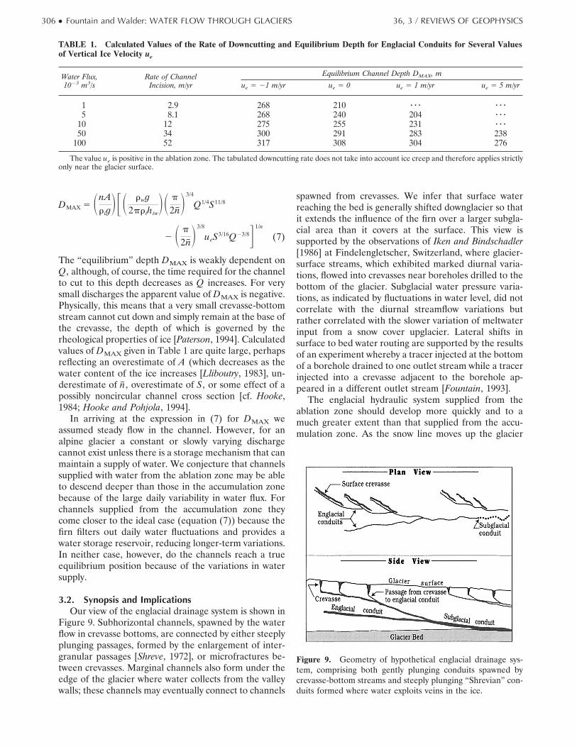
3.2. Synopsis and ImplicationsOur view of the englacial drainage system is shown in
Figure 9. Subhorizontal channels, spawned by the waterflow in crevasse bottoms, are connected by either steeplyplunging passages, formed by the enlargement of inter-granular passages [Shreve, 1972], or microfractures be-tween crevasses. Marginal channels also form under theedge of the glacier where water collects from the valleywalls; these channels may eventually connect to channels
spawned from crevasses. We infer that surface waterreaching the bed is generally shifted downglacier so thatit extends the influence of the firn over a larger subgla-cial area than it covers at the surface. This view issupported by the observations of Iken and Bindschadler[1986] at Findelengletscher, Switzerland, where glacier-surface streams, which exhibited marked diurnal varia-tions, flowed into crevasses near boreholes drilled to thebottom of the glacier. Subglacial water pressure varia-tions, as indicated by fluctuations in water level, did notcorrelate with the diurnal streamflow variations butrather correlated with the slower variation of meltwaterinput from a snow cover upglacier. Lateral shifts insurface to bed water routing are supported by the resultsof an experiment whereby a tracer injected at the bottomof a borehole drained to one outlet stream while a tracerinjected into a crevasse adjacent to the borehole ap-peared in a different outlet stream [Fountain, 1993].
The englacial hydraulic system supplied from theablation zone should develop more quickly and to amuch greater extent than that supplied from the accu-mulation zone. As the snow line moves up the glacier
Figure 9. Geometry of hypothetical englacial drainage sys-tem, comprising both gently plunging conduits spawned bycrevasse-bottom streams and steeply plunging “Shrevian” con-duits formed where water exploits veins in the ice.
TABLE 1. Calculated Values of the Rate of Downcutting and Equilibrium Depth for Englacial Conduits for Several Valuesof Vertical Ice Velocity ue
Water Flux,1023 m3/s
Rate of ChannelIncision, m/yr
Equilibrium Channel Depth DMAX, m
ue 5 21 m/yr ue 5 0 ue 5 1 m/yr ue 5 5 m/yr
1 2.9 268 210 z z z z z z5 8.1 268 240 204 z z z
10 12 275 255 231 z z z50 34 300 291 283 238
100 52 317 308 304 276
The value ue is positive in the ablation zone. The tabulated downcutting rate does not take into account ice creep and therefore applies strictlyonly near the glacier surface.
306 ● Fountain and Walder: WATER FLOW THROUGH GLACIERS 36, 3 / REVIEWS OF GEOPHYSICS
during the summer, ice is exposed in the ablation zone.The combination of lower albedo for ice, compared withsnow, and warmer air temperatures lower on the glacierincreases the water flux into the ablation zone comparedto the accumulation zone. We therefore expect englacialconduits receiving water from the ablation zone to bemore developed compared to the conduits receivingwater from the accumulation zone. The common occur-rence of moulins in the ablation zone rather than in theaccumulation zone probably reflects the difference indrainage development between the two zones. The en-glacial drainage system must be highly dynamic, withchannels being continuously reoriented by differentialshear as ice is advected downstream or severed in ice-falls. Channel segments must frequently close off be-cause their water supply is lost to other channels bydrainage capture or because their connection to theglacier surface is interrupted neither by refreezing dur-ing the winter or by ice creep.
Table 1 indicates that for ice thicknesses of 200 m orless, descending englacial channels may reach the bot-tom of the glacier to become subglacial conduits. Thisprocess provides a mechanism to route water from theglacier surface to the bed and a process by which newsubglacial conduits are formed. We do not expect theenglacial conduits to descend much below 300 m exceptin unusual circumstances; therefore subglacial conduitsfound below 300 m are probably formed from someother mechanism.
Our conception of the englacial drainage system hassignificant implications for overdeepened regions of al-pine glaciers. An overdeepening is a topographic featurethat would form a closed depression, and likely host alake, if the glacier were removed [e.g., Hooke, 1991].Three borehole studies at Glacier d’Argentiere, France[Hantz and Lliboutry, 1983], Storglaciaren [Hooke andPohjola, 1994], and South Cascade Glacier [Hodge, 1976,1979; Fountain, 1994] have involved drilling to the gla-cier bed in overdeepened areas. In all three cases thedrilling was done in the ablation zone, and certain qual-itative features were common:
1. Many boreholes encountered englacial conduits.2. Once boreholes reached the bed, water levels
remained close to the ice overburden pressure and didnot exhibit diurnal fluctuations; thus there was no indi-cation of low-pressure conduits within the overdeepen-ing.
3. Low-pressure conduits seemed to exist near thevalley sides.
These observations seem to contradict our conclusionthat englacial conduits in the ablation zone should nor-mally be efficient at conducting water to the bed. Aresolution of this apparent contradiction is possible,however, if we consider the peculiar effect of the over-deepening on the englacial conduits.
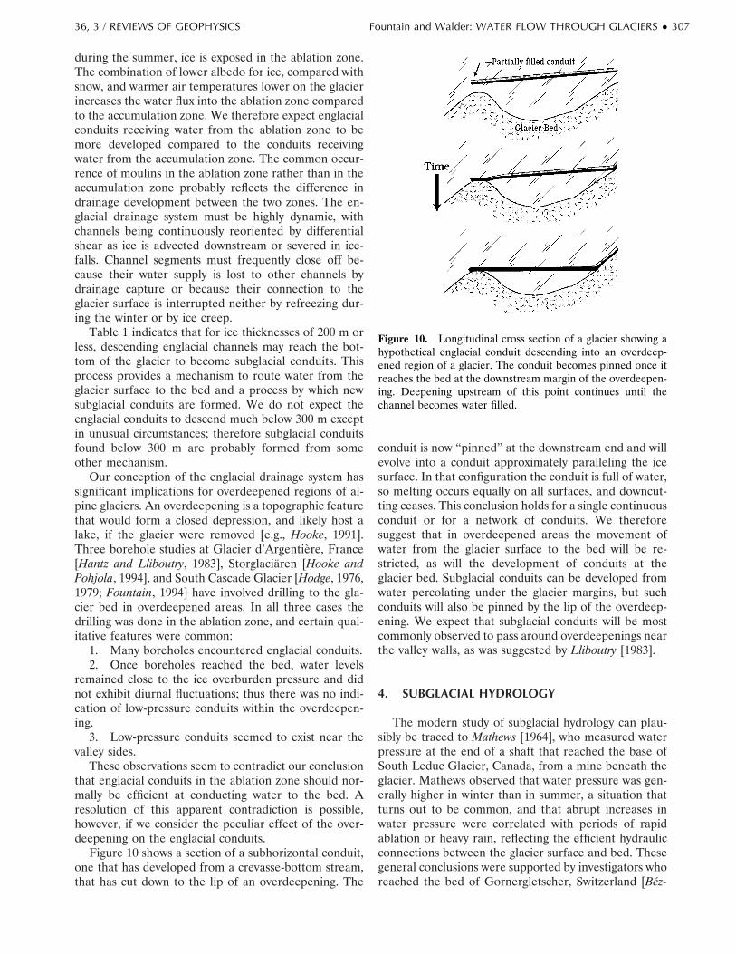
Figure 10 shows a section of a subhorizontal conduit,one that has developed from a crevasse-bottom stream,that has cut down to the lip of an overdeepening. The
conduit is now “pinned” at the downstream end and willevolve into a conduit approximately paralleling the icesurface. In that configuration the conduit is full of water,so melting occurs equally on all surfaces, and downcut-ting ceases. This conclusion holds for a single continuousconduit or for a network of conduits. We thereforesuggest that in overdeepened areas the movement ofwater from the glacier surface to the bed will be re-stricted, as will the development of conduits at theglacier bed. Subglacial conduits can be developed fromwater percolating under the glacier margins, but suchconduits will also be pinned by the lip of the overdeep-ening. We expect that subglacial conduits will be mostcommonly observed to pass around overdeepenings nearthe valley walls, as was suggested by Lliboutry [1983].
4. SUBGLACIAL HYDROLOGY
The modern study of subglacial hydrology can plau-sibly be traced to Mathews [1964], who measured waterpressure at the end of a shaft that reached the base ofSouth Leduc Glacier, Canada, from a mine beneath theglacier. Mathews observed that water pressure was gen-erally higher in winter than in summer, a situation thatturns out to be common, and that abrupt increases inwater pressure were correlated with periods of rapidablation or heavy rain, reflecting the efficient hydraulicconnections between the glacier surface and bed. Thesegeneral conclusions were supported by investigators whoreached the bed of Gornergletscher, Switzerland [Bez-
Figure 10. Longitudinal cross section of a glacier showing ahypothetical englacial conduit descending into an overdeep-ened region of a glacier. The conduit becomes pinned once itreaches the bed at the downstream margin of the overdeepen-ing. Deepening upstream of this point continues until thechannel becomes water filled.
36, 3 / REVIEWS OF GEOPHYSICS Fountain and Walder: WATER FLOW THROUGH GLACIERS ● 307
inge et al., 1973] and Glacier d’Argentiere [Vivian andZumstein, 1973] in connection with hydropower devel-opments. Vivian and Zumstein [1973] also showed thatthe strong diurnal pressure fluctuations observed duringthe melt season were absent during winter.
Iken [1972] measured water pressure in moulins in thesubpolar White Glacier and observed large diurnal vari-ations. Subsequently, various investigators developedtechniques to drill to the glacier bed and used the waterlevel in boreholes as a piezometric measure of subglacialwater pressure. The first systematic borehole studies ofthe subglacial drainage system were done at South Cas-cade Glacier [Hodge, 1976, 1979], Blue Glacier, Wash-ington State, United States [Engelhardt, 1978; Engelhardtet al., 1978], and several Swiss glaciers [Rothlisberger etal., 1979]. In a minority of the boreholes in all of theseglaciers, the water level dropped as soon as the drillreached the glacier bed. Water levels in these boreholesfluctuated diurnally but were usually not closely corre-lated. In a majority of the boreholes the water levelremained high and nearly constant, commonly at a levelcorresponding to a water pressure greater than local iceoverburden pressure, even after the drill reached thebed; a drop in the water level, if it occurred at all, wasdelayed for several days to a few weeks. Such experi-ences with borehole water levels seem to be ubiquitous.Glaciologists commonly describe the first sort of bore-hole as “connected” to the subglacial drainage systemand, assuming that the borehole volume is small com-pared with the volume of accessible subglacial water,treat borehole water level as a manometric measure ofwater pressure at the bed. The second sort of borehole istermed “unconnected” and cannot be used as a manom-eter, as the hole volume is probably large compared withthe volume of accessible subglacial water. Recently,Waddington and Clarke [1995] and Murray and Clarke[1995] have shown that valuable information can becollected from unconnected boreholes when the top ofthe borehole can be sealed, in their case, by freezing, and
water pressure is measured directly at the bed, withoutrelying on the manometric principle.
4.1. Components of the Subglacial Drainage SystemWater emerges at the glacier terminus in a small
number of conduits incised into the basal ice, and it istempting to suppose that these conditions prevail sub-glacially as well. Reality is probably much more compli-cated. There is presently broad agreement among glaci-ologists that water flows at the glacier bed in one or bothof two qualitatively different flow systems (Figure 11),commonly termed “channelized” and “distributed.” Thisterminology is problematic because, as we shall pointout, the distributed system often consists in part of whatcommon sense dictates be called channels. We suggestthat it makes more sense to refer to “fast” and “slow”drainage systems [Raymond et al., 1995]. In the fastsystem, relatively small changes in total system volumeproduce relatively large changes in discharge. The fastsystem has a relatively low surface-to-volume ratio, cov-ers a very small fraction of the glacier bed, and com-prises an arborescent (converging flow) network of con-duits, similar to a subaerial stream network. In the slowsystem, in contrast, relatively large changes in total sys-tem volume produce only small changes in discharge.The slow system has a relatively large surface-to-volumeratio, covers a relatively large fraction of the glacier bed,is nonarborescent, and may involve a variety of compli-cated flow paths at the glacier bed.
The distinction between fast and slow flow systemshas been inferred from variations in borehole waterlevels, from the travel time and dispersion of tracersinjected into glaciers, and from measurements of waterflux and chemistry in streams flowing from glaciers.Under any particular glacier, part of the bed may host afast drainage system while the rest hosts a slow drainagesystem, with transitional zones linking the two. Further-more, the basal drainage system in any particular regionmay switch from one configuration to the other in re-sponse to perturbations in meltwater input.
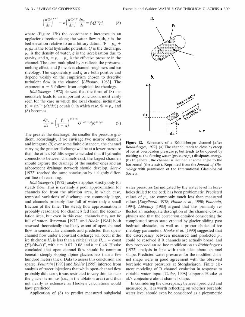
4.1.1. Fast drainage system (Rothlisberger chan-nels). An isolated, water-filled void in a glacier willtend to be closed by inward ice flow unless the waterpressure pw equals the ice overburden pressure pi [Nye,1953]. Englacial or subglacial channels may exist withpw , pi if the flowing water dissipates enough energy asheat to melt the ice and thereby keep the channel open(Figure 12a). Rothlisberger [1972] presented the firstreasonably complete analysis of the hydraulics and ther-modynamics of steady flow in a subglacial channel, andglaciologists now commonly refer to such channels as“Rothlisberger” or “R” channels. Rothlisberger as-sumed that subglacial channels have a semicircular crosssection and that the flowing water must gain or loseenergy so as to remain at the pressure-melting temper-ature. He derived the following differential equation forsteady flow in a channel:
Figure 11. Idealized plan view of (a) an arborescent hydrau-lic (fast) system composed of channels and (b) a nonarbores-cent hydraulic (slow) system.
308 ● Fountain and Walder: WATER FLOW THROUGH GLACIERS 36, 3 / REVIEWS OF GEOPHYSICS
SdF
ds Dp11
2 aSdF
ds Dp dpw
ds 5 bQ2qpen (8)
where (Figure 12b) the coordinate s increases in anupglacier direction along the water flow path, z is thebed elevation relative to an arbitrary datum, F 5 pw 1rwgz is the total hydraulic potential, Q is the discharge,rw is the density of water, g is the acceleration due togravity, and pe 5 pi 2 pw is the effective pressure in thechannel. The term multiplied by a reflects the pressure-melting effect, and b involves channel roughness and icerheology. The exponents p and q are both positive anddepend weakly on the empiricism chosen to describeturbulent flow in the channel [Lliboutry, 1983]. Theexponent n ' 3 follows from empirical ice rheology.
Rothlisberger [1972] showed that the form of (8) im-mediately leads to an important conclusion, most easilyseen for the case in which the local channel inclination(u 5 sin21 (dz/ds)) equals 0, in which case, F 5 pw and(8) becomes
dpw
ds 5 S b
1 2 aD1/~11p!
Q2q/~11p!pen/~11p! (9)
The greater the discharge, the smaller the pressure gra-dient; accordingly, if we envisage two nearby channelsand integrate (9) over some finite distance x, the channelcarrying the greater discharge will be at a lower pressurethan the other. Rothlisberger concluded that if hydraulicconnections between channels exist, the largest channelsshould capture the drainage of the smaller ones and anarborescent drainage network should develop. Shreve[1972] reached the same conclusion by a slightly differ-ent line of reasoning.
Rothlisberger’s [1972] analysis applies strictly only forsteady flow. This is certainly a poor approximation forchannels fed from the ablation area, in which case,temporal variations of discharge are commonly large,and channels probably flow full of water only a smallfraction of the time. The steady flow approximation isprobably reasonable for channels fed from the accumu-lation area, but even in this case, channels may not befull of water. Weertman [1972] and Hooke [1984] bothassessed theoretically the likely extent of open-channelflow in semicircular channels and predicted that open-channel flow under a constant discharge will occur if theice thickness Hi is less than a critical value Hcrit 5 constQa(dF/ds)b, with a ' 0.07–0.08 and b ' 0.46. Hookeconcluded that open-channel flow should be commonbeneath steeply sloping alpine glaciers less than a fewhundred meters thick. Data to assess this conclusion aresparse. Fountain [1993] and Kohler [1995] inferred fromanalysis of tracer injections that while open-channel flowprobably did occur, it was restricted to very thin ice nearthe glacier terminus (i.e., in the ablation area) and thusnot nearly as extensive as Hooke’s calculations wouldhave predicted.
Application of (8) to predict measured subglacial
water pressures (as indicated by the water level in bore-holes drilled to the bed) has been problematic. Predictedvalues of pw are commonly much less than measuredvalues [Engelhardt, 1978; Hooke et al., 1990; Fountain,1994]. Lliboutry [1983] argued that this primarily re-flected an inadequate description of the channel-closurephysics and that the correction entailed considering thecomplicated stress state created by glacier sliding pastbedrock obstacles, as well as a proper choice of icerheology parameters. Hooke et al. [1990] suggested thatthe discrepancy between measured and predicted pw
could be resolved if R channels are actually broad, andthey proposed an ad hoc modification to Rothlisberger’s[1972] analysis in line with their idea about channelshape. Predicted water pressures for the modified chan-nel shape were in good agreement with the observedborehole water pressures at Storglaciaren. Finite ele-ment modeling of R channel evolution in response tovariable water input [Cutler, 1998] supports Hooke etal.’s conjecture about channel shape.
In considering the discrepancy between predicted andmeasured pw it is worth reflecting on whether boreholewater level should even be considered as a piezometric
Figure 12. Schematic of a Rothlisberger channel [afterRothlisberger, 1972]. (a) The channel tends to close by creepof ice at overburden pressure pi but tends to be opened bymelting as the flowing water (pressure pw) dissipates energy.(b) In general, the channel is inclined at some angle to thehorizontal (the x axis). Reprinted from the Journal of Gla-ciology with permission of the International GlaciologicalSociety.
36, 3 / REVIEWS OF GEOPHYSICS Fountain and Walder: WATER FLOW THROUGH GLACIERS ● 309

measurement of water pressure in an R channel. Bore-hole water level does not reflect basal water pressure ifwater enters the borehole either at the glacier surface orenglacially. Surface runoff can be diverted from a bore-hole, but the same is not true for water entering engla-cially, and there is a substantial body of evidence thatboreholes do commonly intersect englacial channelsduring drilling. Moreover, although R channels havecertainly been seen at the margins of glaciers (Figure13), there is no unequivocal evidence that a borehole hasever intersected an R channel. If a borehole intersects apart of the basal hydraulic system that drains to a sub-glacial channel, then borehole water levels will necessar-ily reflect pw greater than that in the channel [cf. En-gelhardt, 1978]. Until a borehole can be drilled thatunambiguously intersects a subglacial channel and that isnot adversely affected by englacial water input, it isperhaps premature to discount the quantitative accuracyof (8). Several investigators seem to have drilled bore-holes that came tantalizingly close to basal channels.Water level in borehole U of Engelhardt et al. [1978] fellto the glacier bed a few days after the borehole wascompleted, and a sounding float lowered into the bore-hole did not stop at the bottom of the borehole but ranout along some sort of basal passage as far as it wasallowed to go. Hantz and Lliboutry [1983], Fountain[1994], and Hubbard et al. [1995] found that in a fewboreholes, there were large diurnal pressure fluctua-tions, with minimum values of pw close to atmosphericpressure, and concluded that these boreholes were effi-ciently connected to R channels.
Studies by Fountain [1994] and by Hubbard et al.[1995] at two different glaciers yielded intriguingly sim-
ilar results bearing on the hydraulic connection betweensubglacial channels and the surrounding, presumablyslow basal drainage system. At both glaciers, water levelmeasurements in arrays of boreholes in the ablation areaindicated the existence of a zone, elongated along the iceflow direction but only a few tens of meters wide, inwhich basal water pressure fluctuated greatly and com-monly fell to atmospheric values. To either side of thiszone, basal water pressure was generally high and fluc-tuated relatively little. A plausible interpretation is thatan R channel existed and was efficiently connected tothe ablation-zone input, whereas the adjacent (slow)hydraulic system was poorly connected to the channeland was fed from farther upglacier. We will elaborate onthis idea in our discussion of the temporal evolution ofthe basal drainage system in section 5.
4.1.2. Slow drainage system. The slow drainagesystem comprises several morphologically distinct flowpathways. Most of the discharge in the slow systemmoves through cavities and subglacial sediment. A wide-spread, thin water film also forms part of the slowsystem; this film accommodates little water flux but mayaffect the glacier sliding speed as well as water chemistry[Hallet, 1976, 1979].
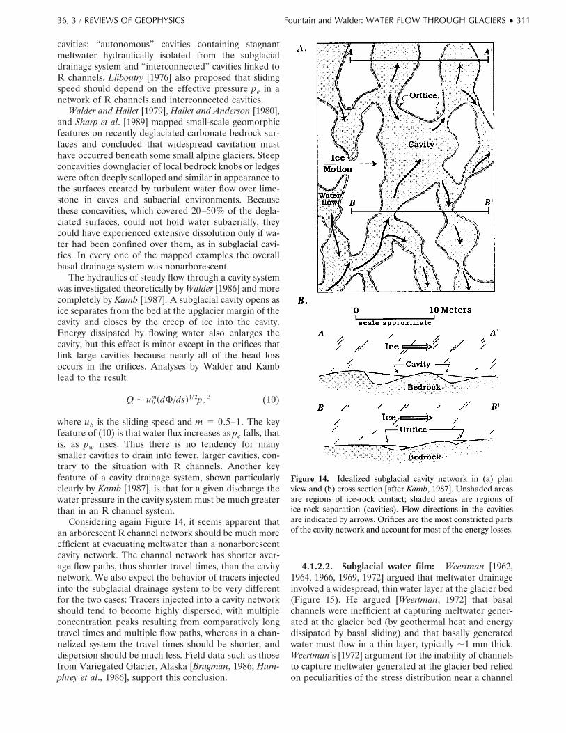
4.1.2.1. Subglacial cavities: A subglacial cavityforms where sliding ice separates from the glacier bed(Figure 14). Large cavities beneath thin ice are some-times accessible from the glacier margin [e.g., Andersonet al., 1982]. Cavity formation is favored by rapid slidingand high bed roughness [Nye, 1970]. Lliboutry [1965,1968] was the first to propose that cavitation played acritical role in glacier sliding. In later papers [Lliboutry,1976, 1978, 1979] he argued that there were two types of
Figure 13. Subglacial conduit incised into ice near the margin of South Cascade Glacier. The height of theconduit is ;1.5 m. Note three important features: The ice is resting on unconsolidated sediments, the channelis not full of water, and the cross-sectional shape is flattened instead of semicircular.
310 ● Fountain and Walder: WATER FLOW THROUGH GLACIERS 36, 3 / REVIEWS OF GEOPHYSICS
cavities: “autonomous” cavities containing stagnantmeltwater hydraulically isolated from the subglacialdrainage system and “interconnected” cavities linked toR channels. Lliboutry [1976] also proposed that slidingspeed should depend on the effective pressure pe in anetwork of R channels and interconnected cavities.
Walder and Hallet [1979], Hallet and Anderson [1980],and Sharp et al. [1989] mapped small-scale geomorphicfeatures on recently deglaciated carbonate bedrock sur-faces and concluded that widespread cavitation musthave occurred beneath some small alpine glaciers. Steepconcavities downglacier of local bedrock knobs or ledgeswere often deeply scalloped and similar in appearance tothe surfaces created by turbulent water flow over lime-stone in caves and subaerial environments. Becausethese concavities, which covered 20–50% of the degla-ciated surfaces, could not hold water subaerially, theycould have experienced extensive dissolution only if wa-ter had been confined over them, as in subglacial cavi-ties. In every one of the mapped examples the overallbasal drainage system was nonarborescent.
The hydraulics of steady flow through a cavity systemwas investigated theoretically by Walder [1986] and morecompletely by Kamb [1987]. A subglacial cavity opens asice separates from the bed at the upglacier margin of thecavity and closes by the creep of ice into the cavity.Energy dissipated by flowing water also enlarges thecavity, but this effect is minor except in the orifices thatlink large cavities because nearly all of the head lossoccurs in the orifices. Analyses by Walder and Kamblead to the result
Q , ubm~dF/ds!1/ 2pe
23 (10)
where ub is the sliding speed and m 5 0.5–1. The keyfeature of (10) is that water flux increases as pe falls, thatis, as pw rises. Thus there is no tendency for manysmaller cavities to drain into fewer, larger cavities, con-trary to the situation with R channels. Another keyfeature of a cavity drainage system, shown particularlyclearly by Kamb [1987], is that for a given discharge thewater pressure in the cavity system must be much greaterthan in an R channel system.
Considering again Figure 14, it seems apparent thatan arborescent R channel network should be much moreefficient at evacuating meltwater than a nonarborescentcavity network. The channel network has shorter aver-age flow paths, thus shorter travel times, than the cavitynetwork. We also expect the behavior of tracers injectedinto the subglacial drainage system to be very differentfor the two cases: Tracers injected into a cavity networkshould tend to become highly dispersed, with multipleconcentration peaks resulting from comparatively longtravel times and multiple flow paths, whereas in a chan-nelized system the travel times should be shorter, anddispersion should be much less. Field data such as thosefrom Variegated Glacier, Alaska [Brugman, 1986; Hum-phrey et al., 1986], support this conclusion.
4.1.2.2. Subglacial water film: Weertman [1962,1964, 1966, 1969, 1972] argued that meltwater drainageinvolved a widespread, thin water layer at the glacier bed(Figure 15). He argued [Weertman, 1972] that basalchannels were inefficient at capturing meltwater gener-ated at the glacier bed (by geothermal heat and energydissipated by basal sliding) and that basally generatedwater must flow in a thin layer, typically ;1 mm thick.Weertman’s [1972] argument for the inability of channelsto capture meltwater generated at the glacier bed reliedon peculiarities of the stress distribution near a channel
Figure 14. Idealized subglacial cavity network in (a) planview and (b) cross section [after Kamb, 1987]. Unshaded areasare regions of ice-rock contact; shaded areas are regions ofice-rock separation (cavities). Flow directions in the cavitiesare indicated by arrows. Orifices are the most constricted partsof the cavity network and account for most of the energy losses.
36, 3 / REVIEWS OF GEOPHYSICS Fountain and Walder: WATER FLOW THROUGH GLACIERS ● 311

in a material with the rheological properties of glacierice; he concluded that except near the margins of achannel the pressure gradient at the glacier bed woulddrive water away from the channel and that water layerdrainage was the only plausible alternative. Weertman’s[1972] argument was formulated with the implicit as-sumptions that (1) the glacier-bedrock interface is pla-nar and free of rock debris and (2) the bedrock isimpermeable. Actual glacier beds are rough on a rangeof length scales, and it is probable that there wouldalways be flow paths through the zone of supposedlyadverse pressure gradient. Moreover, if there is a per-meable layer of rock debris at the glacier bed, and thisseems to be typically the case, then meltwater can flow toa channel through the permeable rock debris. The waterlayer concept has two other problems. Nye [1973]pointed out a fundamental inconsistency in postulating awidespread water layer that provides both a path forlocal redistribution of meltwater involved in the regela-tion-sliding process, which requires a layer thickness of;1 mm, and a path for basally generated, through-flowing meltwater, with a characteristic layer thicknessof ;1 mm. Some other paths must exist to allow for thenet downglacier flow of meltwater. Finally, a water layerat the glacier bed is not stable against perturbations inlayer thickness. The instability, proposed by Nye [1976]and analyzed by Walder [1982], arises because thethicker the layer, the more energy is dissipated by vis-cous forces and thus the greater is the melt rate. Vari-ations in water layer thickness are therefore magnified,and protochannels tend to develop.
4.1.2.3. Nye channels: Nye [1973] suggested thatR channels must be transient features, being squeezedshut as they are advected against the upglacier sides ofbumps on the glacier bed, and that the maintenance ofcontinuous subglacial meltwater drainage requires thepresence of channels incised into the bed (Figure 16).Studies of recently deglaciated bedrock surfaces cited insection 4.1.2.1 in connection with the distribution ofcavities [Walder and Hallet, 1979; Hallet and Anderson,1980; Sharp et al., 1989] also revealed large numbers ofNye channels, typically ;0.1 m deep, preferentially ori-ented along the former ice flow direction and commonly
connecting cavities to one another. Because these obser-vations were all made on highly soluble carbonate bed-rock, it is uncertain how representative they are ofglacier beds in general. However, it seems clear thatbeneath at least some small alpine glaciers, Nye channelsconstitute a morphologically distinct part of the slowdrainage system. Within the context of present-day the-ory, however, their hydraulic behavior, at least on themapped glacier beds mentioned above, is simply that ofelongated orifices in a cavity network.
4.1.2.4. Subglacial sediments: Recently deglaci-ated bedrock surfaces nearly devoid of unconsolidatedsediment are rare, and it is likely that most glaciers arein fact underlain by a spatially variable, perhaps discon-tinuous layer of rock debris (Figure 17), which for sim-plicity (and without sedimentological connotations) wewill call glacial till. The till acts as a confined aquifer aslong as it is much more permeable than the underlyingbedrock (Figure 18); this seems to have been first rec-ognized by Mathews and Mackay [1960], although it wasnot widely appreciated by glaciologists until the work ofBoulton and Jones [1979]. Even a pervasive basal tilllayer, however, can evacuate only a small fraction of thetotal water flux through the glacier. Consider, for exam-ple, a till layer with a thickness B 5 0.1 m and ahydraulic conductivity k in the range of 1028–1024 m/s,values that are plausible in light of the field evidencediscussed below. Assuming that this layer covers theentire glacier bed, of width W transverse to the ice flowdirection, the net meltwater flux through the layer is
QDarcy 5 SkBWrwg DSdF
ds D (11)
The gradient (1/rwg)(dF/ds), determined largely by theice-surface slope [e.g., Shreve, 1972], is typically ;0.1 foralpine glaciers. Taking W 5 1 km, we find QDarcy '1027–1023 m3/s, as compared with typical melt-seasondischarges of ;1–10 m3/s and winter discharges of per-haps 0.01–0.1 m3/s [cf. Lliboutry, 1983]. Analogous cal-culations with similar conclusions have been presentedfor till aquifers beneath ice sheets [Boulton and Jones,1979] and ice streams [Alley, 1989]. We conclude thatmost of the water draining from a till-floored glaciereither avoids the bed altogether and simply flows engla-
Figure 15. Regelation film of water at the ice-rock interface.
Figure 16. Nye channels (channels incised into subglacialbedrock). A Nye channel may be accompanied by a Rothlis-berger channel incised into the overlying ice.
312 ● Fountain and Walder: WATER FLOW THROUGH GLACIERS 36, 3 / REVIEWS OF GEOPHYSICS
cially or else passes directly from englacial conduits intobasal conduits.
The characteristics of subglacial channels coexistingwith a till aquifer (Figure 19) were analyzed by Walderand Fowler [1994]. The geometry of a sediment-flooredchannel develops in response to flow interactions withboth the ice roof and the sediment floor. As in the caseof a rock-floored R channel, the channel is enlarged bymelting of the ice and shrunken by inward creep of theice. In addition, the channel may be enlarged by fluvialerosion and closed by inward creep of the till [Boultonand Hindmarsh, 1987]. Walder and Fowler showed thata network of sediment-floored channels may exist in twoasymptotically distinct conditions: either an arborescentnetwork of sediment-floored R channels at pe . p or anonarborescent network of wide, shallow, ice-roofed ca-nals eroded into the sediment at pe , p, where p is a“critical” effective pressure. Which drainage network is
stable depends on the magnitude of p (determined pri-marily by the creep properties of the ice and sediment)and the hydraulic gradient, which is approximated by theice-surface slope. For very low hydraulic gradients typi-cal of ice streams and ice sheets the drainage networkshould comprise nonarborescent canals. For large hy-draulic gradients typical of alpine glaciers the drainagesystem should comprise arborescent R channels overrelatively “stiff” till, with properties like those of theBreidamerkurjokull till in Iceland [Boulton and Hind-marsh, 1987]; however, as was pointed out by Fountainand Walder [1993], for alpine glaciers floored by rela-tively “soft” till [e.g., Humphrey et al., 1993] the stabledrainage system would consist of nonarborescent canals.
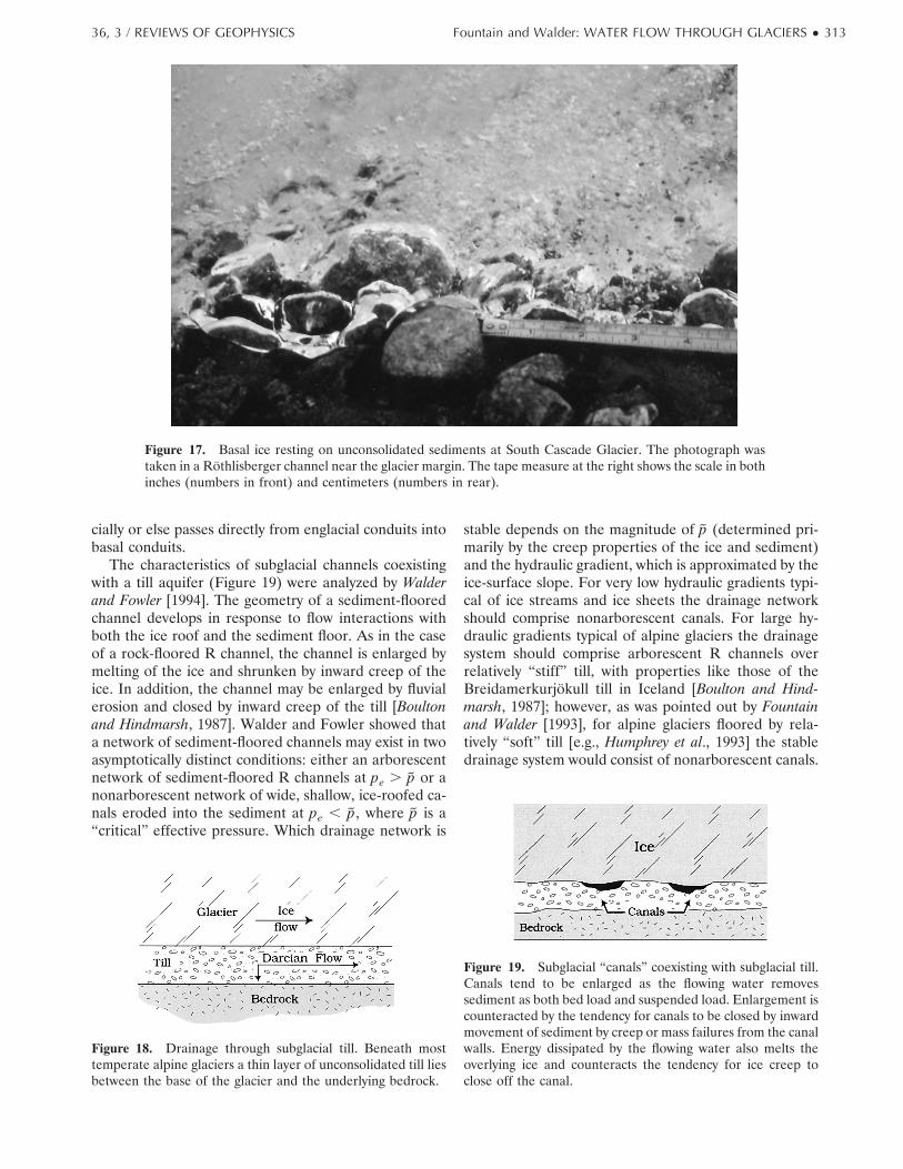
Figure 17. Basal ice resting on unconsolidated sediments at South Cascade Glacier. The photograph wastaken in a Rothlisberger channel near the glacier margin. The tape measure at the right shows the scale in bothinches (numbers in front) and centimeters (numbers in rear).
Figure 18. Drainage through subglacial till. Beneath mosttemperate alpine glaciers a thin layer of unconsolidated till liesbetween the base of the glacier and the underlying bedrock.
Figure 19. Subglacial “canals” coexisting with subglacial till.Canals tend to be enlarged as the flowing water removessediment as both bed load and suspended load. Enlargement iscounteracted by the tendency for canals to be closed by inwardmovement of sediment by creep or mass failures from the canalwalls. Energy dissipated by the flowing water also melts theoverlying ice and counteracts the tendency for ice creep toclose off the canal.
36, 3 / REVIEWS OF GEOPHYSICS Fountain and Walder: WATER FLOW THROUGH GLACIERS ● 313
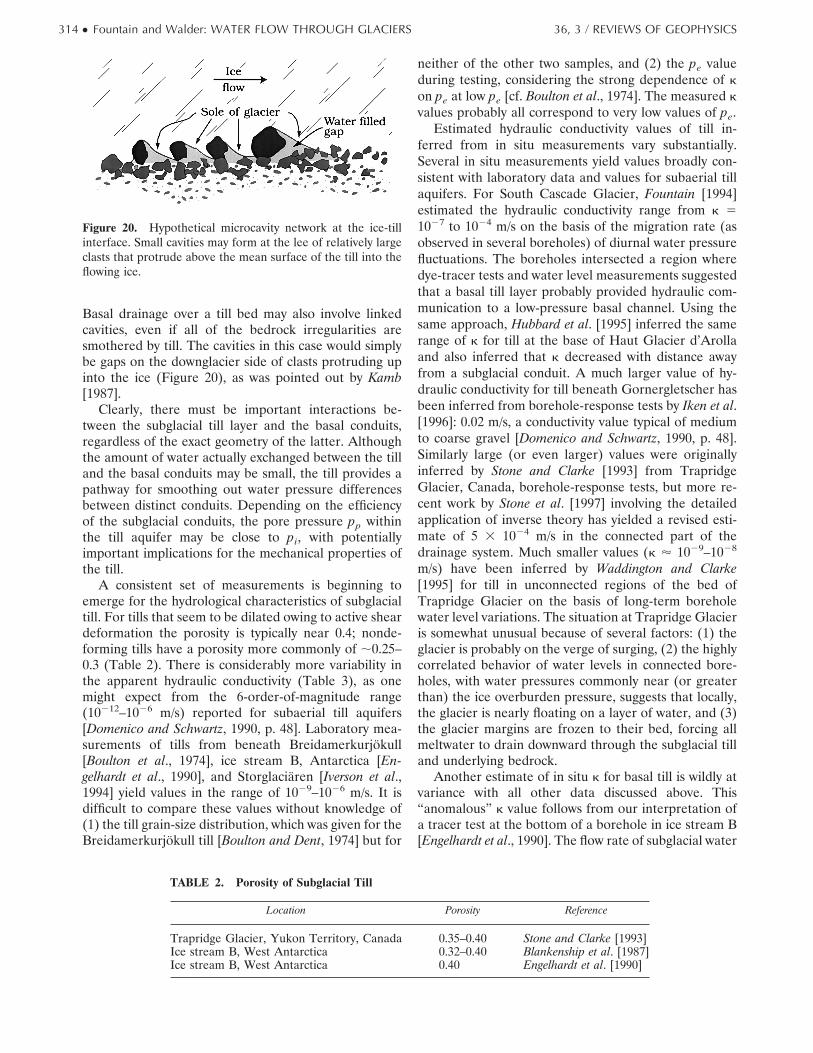
Basal drainage over a till bed may also involve linkedcavities, even if all of the bedrock irregularities aresmothered by till. The cavities in this case would simplybe gaps on the downglacier side of clasts protruding upinto the ice (Figure 20), as was pointed out by Kamb[1987].
Clearly, there must be important interactions be-tween the subglacial till layer and the basal conduits,regardless of the exact geometry of the latter. Althoughthe amount of water actually exchanged between the tilland the basal conduits may be small, the till provides apathway for smoothing out water pressure differencesbetween distinct conduits. Depending on the efficiencyof the subglacial conduits, the pore pressure pp withinthe till aquifer may be close to pi, with potentiallyimportant implications for the mechanical properties ofthe till.
A consistent set of measurements is beginning toemerge for the hydrological characteristics of subglacialtill. For tills that seem to be dilated owing to active sheardeformation the porosity is typically near 0.4; nonde-forming tills have a porosity more commonly of ;0.25–0.3 (Table 2). There is considerably more variability inthe apparent hydraulic conductivity (Table 3), as onemight expect from the 6-order-of-magnitude range(10212–1026 m/s) reported for subaerial till aquifers[Domenico and Schwartz, 1990, p. 48]. Laboratory mea-surements of tills from beneath Breidamerkurjokull[Boulton et al., 1974], ice stream B, Antarctica [En-gelhardt et al., 1990], and Storglaciaren [Iverson et al.,1994] yield values in the range of 1029–1026 m/s. It isdifficult to compare these values without knowledge of(1) the till grain-size distribution, which was given for theBreidamerkurjokull till [Boulton and Dent, 1974] but for
neither of the other two samples, and (2) the pe valueduring testing, considering the strong dependence of kon pe at low pe [cf. Boulton et al., 1974]. The measured kvalues probably all correspond to very low values of pe.
Estimated hydraulic conductivity values of till in-ferred from in situ measurements vary substantially.Several in situ measurements yield values broadly con-sistent with laboratory data and values for subaerial tillaquifers. For South Cascade Glacier, Fountain [1994]estimated the hydraulic conductivity range from k 51027 to 1024 m/s on the basis of the migration rate (asobserved in several boreholes) of diurnal water pressurefluctuations. The boreholes intersected a region wheredye-tracer tests and water level measurements suggestedthat a basal till layer probably provided hydraulic com-munication to a low-pressure basal channel. Using thesame approach, Hubbard et al. [1995] inferred the samerange of k for till at the base of Haut Glacier d’Arollaand also inferred that k decreased with distance awayfrom a subglacial conduit. A much larger value of hy-draulic conductivity for till beneath Gornergletscher hasbeen inferred from borehole-response tests by Iken et al.[1996]: 0.02 m/s, a conductivity value typical of mediumto coarse gravel [Domenico and Schwartz, 1990, p. 48].Similarly large (or even larger) values were originallyinferred by Stone and Clarke [1993] from TrapridgeGlacier, Canada, borehole-response tests, but more re-cent work by Stone et al. [1997] involving the detailedapplication of inverse theory has yielded a revised esti-mate of 5 3 1024 m/s in the connected part of thedrainage system. Much smaller values (k ' 1029–1028
m/s) have been inferred by Waddington and Clarke[1995] for till in unconnected regions of the bed ofTrapridge Glacier on the basis of long-term boreholewater level variations. The situation at Trapridge Glacieris somewhat unusual because of several factors: (1) theglacier is probably on the verge of surging, (2) the highlycorrelated behavior of water levels in connected bore-holes, with water pressures commonly near (or greaterthan) the ice overburden pressure, suggests that locally,the glacier is nearly floating on a layer of water, and (3)the glacier margins are frozen to their bed, forcing allmeltwater to drain downward through the subglacial tilland underlying bedrock.
Another estimate of in situ k for basal till is wildly atvariance with all other data discussed above. This“anomalous” k value follows from our interpretation ofa tracer test at the bottom of a borehole in ice stream B[Engelhardt et al., 1990]. The flow rate of subglacial water
Figure 20. Hypothetical microcavity network at the ice-tillinterface. Small cavities may form at the lee of relatively largeclasts that protrude above the mean surface of the till into theflowing ice.
TABLE 2. Porosity of Subglacial Till
Location Porosity Reference
Trapridge Glacier, Yukon Territory, Canada 0.35–0.40 Stone and Clarke [1993]Ice stream B, West Antarctica 0.32–0.40 Blankenship et al. [1987]Ice stream B, West Antarctica 0.40 Engelhardt et al. [1990]
314 ● Fountain and Walder: WATER FLOW THROUGH GLACIERS 36, 3 / REVIEWS OF GEOPHYSICS
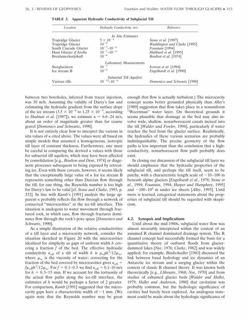
between two boreholes, inferred from tracer injection,was 30 m/h. Assuming the validity of Darcy’s law andestimating the hydraulic gradient from the surface slopeof the ice stream (3.5 3 1024 to 1.25 3 1023, accordingto Shabtaie et al. [1987]), we estimate k 5 6.6–24 m/s,about an order of magnitude greater than for coarsegravel [Domenico and Schwartz, 1990].
It is not entirely clear how to interpret the various insitu values of k cited above. The values were all based onsimple models that assumed a homogeneous, isotropictill layer of constant thickness. Furthermore, one mustbe careful in comparing the derived k values with thosefor subaerial till aquifers, which may have been affectedby consolidation [e.g., Boulton and Dent, 1974] or diage-netic processes subsequent to being exposed by retreat-ing ice. Even with these caveats, however, it seems likelythat the exceptionally large value of k for ice stream Brepresents something other than Darcian flow throughthe till; for one thing, the Reynolds number is too highfor Darcy’s law to be valid [cf. Stone and Clarke, 1993, p.332]. In line with Kamb’s [1991] analysis the large ap-parent k probably reflects the flow through a network ofconnected “microcavities” at the ice-till interface. Thissituation is analogous to water movement through frac-tured rock, in which case, flow through fractures domi-nates flow through the rock’s pore space [Domenico andSchwartz, 1990].
As a simple illustration of the relative conductivitiesof a till layer and a microcavity network, consider thesituation sketched in Figure 20 with the microcavitiesidealized for simplicity as gaps of uniform width h cov-ering a fraction f of the bed. The effective hydraulicconductivity keff of a slit of width h is rwgh2/12mw,where mw is the viscosity of water; correcting for thefraction of the bed covered by microcavities gives keff 5frwgh2/12mw. For f 5 0.1–0.5 we find keff 5 0.1–10 m/sfor h 5 0.3–15 mm. If we account for the tortuosity ofthe actual flow paths along the ice-till interface, theestimates of h would be perhaps a factor of 2 greater.For comparison, Kamb [1991] suggested that the micro-cavity gaps have a characteristic width of ;1 mm. (Weagain note that the Reynolds number may be great
enough that flow is actually turbulent.) The microcavityconcept seems better grounded physically than Alley’s[1989] suggestion that flow takes place in a nonuniform“Weertman” water layer. On theoretical grounds itseems plausible that drainage at the bed may also in-volve wide, shallow, nonarborescent canals incised intothe till [Walder and Fowler, 1994], particularly if waterreaches the bed from the glacier surface. Realistically,the hydraulics of these various scenarios are probablyindistinguishable. The precise geometry of the flowpaths is less important than the conclusion that a high-conductivity, nonarborescent flow path probably doesexist.
In closing our discussion of the subglacial till layer weshould emphasize that the hydraulic properties of thesubglacial till, and perhaps the till itself, seem to bepatchy, with a characteristic length scale of ;10–100 mbeneath alpine glaciers [Engelhardt et al., 1978; Stone etal., 1994; Fountain, 1994; Harper and Humphrey, 1995]and ;100–104 m under ice sheets [Alley, 1993]. Untilmore is learned, categorical statements about the prop-erties of subglacial till should be regarded with skepti-cism.
4.2. Synopsis and ImplicationsUntil about the mid-1980s, subglacial water flow was
almost invariably interpreted within the context of anassumed R channel dominated drainage system. The Rchannel concept had successfully formed the basis for aquantitative theory of outburst floods from glacier-dammed lakes [Nye, 1976; Clarke, 1982] and was widelyapplied; for example, Bindschadler [1983] discussed thelink between basal hydrology and ice dynamics of anAntarctic ice stream and a surging glacier within thecontext of classic R channel theory. It was known boththeoretically [e.g., Lliboutry, 1968; Nye, 1970] and fromstudies of exhumed glacier beds [Walder and Hallet,1979; Hallet and Anderson, 1980] that cavitation wasprobably common, but the hydrologic significance ofcavities had barely been explored. An analogous state-ment could be made about the hydrologic significance of
TABLE 3. Apparent Hydraulic Conductivity of Subglacial Till
Location Hydraulic Conductivity, m/s Reference
In Situ EstimatesTrapridge Glacier 5 3 1024 Stone et al. [1997]Trapridge Glacier 1029 Waddington and Clarke [1995]South Cascade Glacier 1027–1024 Fountain [1994]Haut Glacier d’Arolla 1027–1024 Hubbard et al. [1995]Breidamerkurjokull 1026 Boulton et al. [1974]
Laboratory MeasurementsStorglaciaren 1027 Iverson et al. [1994]Ice stream B 1029 Engelhardt et al. [1990]
Subaerial Till AquifersVarious tills 10212–1026 Domenico and Schwartz [1990]
36, 3 / REVIEWS OF GEOPHYSICS Fountain and Walder: WATER FLOW THROUGH GLACIERS ● 315
unconsolidated sediment at the glacier bed [Engelhardtet al., 1978].
By about 1990 the way that glaciologists envisagedbasal water flow had greatly changed, largely owing tothe realization that R channels could not form the basisfor an explanation of observations from surging Varie-gated Glacier [Kamb et al., 1985] and rapidly moving icestream B in Antarctica [Blankenship et al., 1987]. Theo-ries were developed to elucidate the hydraulics of waterflow through linked cavities [Walder, 1986; Kamb, 1987],deformable till [Alley et al., 1987], and till-floored chan-nels [Walder and Fowler, 1994]. The interpretive frame-work shifted to one in which glaciologists usually tried toexplain field data from any particular glacier in terms ofa basal drainage system presumed to be dominated byone or another of three morphologically distinct compo-nents: R channel, cavity, or till.
We believe that the most significant general conclu-sion to be drawn from the last 3 decades of investigationsis that the basal drainage system is highly heterogeneousin both space and time. It is probable that the variouscomponents of the subglacial drainage system have nowall been identified, and their hydraulics have been rea-sonably well described. However, the distribution, spa-tial extent, and seasonal evolution of each drainage-system component under any particular glacier are stilluncertain. The way in which the drainage-system com-ponents interact also remains poorly understood. Theseissues need to be addressed to improve our understand-ing of both glacier dynamics and hydrology. The linkbetween the subglacial drainage system and groundwa-ter flow also remains unexplored aside from gross gen-eralizations [cf. Lliboutry, 1983].
To summarize, the drainage system under any givenglacier comprises several or all of the morphologicallydistinct components described in this section. A slow,nonarborescent drainage system, comprising a mixtureof elements including cavities, permeable till, and con-duits incised into the bed (i.e., Nye channels and canals),probably covers most of the glacier bed and is nearlyfixed relative to the bed. The water pressure in the slowdrainage system is commonly close to the ice-overbur-den pressure. A fast drainage system consisting of arbo-rescent R channels may also exist. The fast drainagesystem, being incised into the base of the glacier, isadvected by glacier movement and probably undergoescontinuous rearrangement as the sliding ice interactswith the rough bed beneath. The water pressure in thefast drainage system is commonly much less than the iceoverburden pressure; indeed, the fast drainage channelsmay be only partly full most of the time, in which casethe flow is unpressurized except at times of peak diurnaldischarge. Both the fast and slow components of thebasal drainage system probably undergo major temporalchanges, particularly at the beginning and end of themelt season, as discussed in section 5.
5. TEMPORAL EVOLUTION OFTHE DRAINAGE SYSTEM
Meltwater discharge from temperate alpine glaciersvaries typically by about 2 orders of magnitude fromwinter to summer, so it seems plausible that the subgla-cial drainage system must also undergo seasonalchanges. Data bearing on this question are sparse, aslittle information is available except for the ablationseason. Moreover, there is not much of a theoreticalfoundation for understanding time-dependent dis-charge.
It is very unlikely that a robust system of R channelscan survive from year to year except perhaps beneath iceonly a few tens of meters thick. This is readily seen byconsidering the fate of a channel of radius R that be-comes empty of water at the end of the melt season. Thechannel will tend to be closed by inward creep of ice,with the channel radius as a function of time given by[Weertman, 1972]
R~t! 5 R0 exp ~2t/t! (12)
where R0 is the radius at the end of the melt season. Thecharacteristic time t is proportional to pi
2n, where n '3. For ice thicknesses $150 m a channel that has sur-vived the winter will have a radius at the beginning of themelt season of #1023 R0, probably no more than a fewmillimeters for even the main trunk channels. A similarargument can be made for the closure of Nye channelsand sediment-floored canals. In contrast, a cavity net-work ought to be able to survive from 1 year to the nextbecause cavities are maintained open primarily by basalsliding and only secondarily by melting. As long as slid-ing does not cease in winter and the accumulation ofsediment is not too great, cavities stay open, althoughsome of the links between the cavities may become quiteconstricted. Thus we suggest that the subglacial drainagesystem beneath the entire glacier at the beginning of themelt season should typically be cavity dominated, withthe cavities probably poorly connected. A similar sce-nario has been discussed by Raymond [1987] in connec-tion with glacier-surge initiation, which we will discuss insection 8. In the case of a sediment-floored glacier thecavities will be located at the downglacier sides of iso-lated bedrock protuberances or relatively large bouldersthat protrude above the mean local till surface [Kamb,1987].
At the beginning of the melt season, once meltwaterpenetrates the winter snowpack, it flows into crevassesand preexisting englacial channels linked to the cre-vasses. In the event that such links were severed duringwinter, water will pond in the crevasses while slowlyescaping through intergranular passages or microfrac-tures in the ice; the escaping water eventually enlargesthese flow paths by melting, and the cycle of englacialchannel development starts anew. The englacial networkof channels begins to fill again, and water makes its way
316 ● Fountain and Walder: WATER FLOW THROUGH GLACIERS 36, 3 / REVIEWS OF GEOPHYSICS
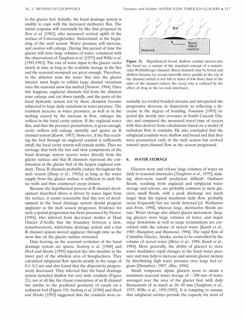
to the glacier bed. Initially, the basal drainage system isunable to cope with the increased meltwater flux. Theinitial response will essentially be like that proposed byIken et al. [1983], who measured vertical uplift of thesurface of Unteraargletscher, Switzerland, at the begin-ning of the melt season: Water pressure will increase,and cavities will enlarge. During this period of time theglacier will store large volumes of water, consistent withthe observations of Tangborn et al. [1975] and Willis et al.[1991/1992]. The rate of water input to the glacier variesslowly in time as long as the available storage in the firnand the seasonal snowpack are great enough. Therefore,in the ablation zone the water flux into the glacierinterior must begin to exhibit large diurnal variationsonce the seasonal snow has melted [Nienow, 1994]. Oncethis happens, englacial channels fed from the ablationzone enlarge and cut down rapidly, and the parts of thebasal hydraulic system fed by these channels becomesubjected to large daily variations in water pressure. Thetransient increase in water pressures, as well as in themelting caused by the increase in flow, enlarges theorifices in the basal cavity system. If the englacial waterflux, and thus the pressure perturbation, is great enough,cavity orifices will enlarge unstably and spawn an Rchannel system [Kamb, 1987]. However, if the flux reach-ing the bed through an englacial conduit is sufficientlysmall, the local cavity system will remain stable. Thus weenvisage that both the fast and slow components of thebasal drainage system receive water directly from theglacier surface and that R channels represent the con-tinuation at the glacier bed of the largest englacial con-duits. These R channels probably endure throughout themelt season [Sharp et al., 1993a] as long as the watersupply from the glacier surface is sufficient to melt theice walls and thus counteract creep closure.
Because the hypothetical process of R channel devel-opment described above is driven by water input fromthe surface, it seems reasonable that this sort of devel-opment in the basal drainage system should progressupglacier as the melt season progresses. Evidence forsuch a spatial progression has been presented by Nienow[1994], who inferred from dye-tracer studies at HautGlacier d’Arolla that the boundary between a slow,nonarborescent, wintertime drainage system and a fastR channel system moved upglacier through time as thesnow line on the glacier surface retreated.
Data bearing on the seasonal evolution of the basaldrainage system are sparse. Seaberg et al. [1988] andHock and Hooke [1993] injected dye into moulins in thelower part of the ablation area of Storglaciaren. Theycalculated subglacial flow speeds mostly in the range of0.1–0.2 m/s and also found that the dispersivity progres-sively decreased. They inferred that the basal drainagesystem included shallow but very wide conduits (Figure21), not at all like the classic conception of an R channelbut similar to the predicted geometry of canals on asediment bed (Figure 19). Seaberg et al. [1988] and Hockand Hooke [1993] suggested that the conduits were es-
sentially ice-roofed braided streams and interpreted theprogressive decrease in dispersivity as reflecting a de-crease in the degree of braiding. Fountain [1993] in-jected dye mostly into crevasses at South Cascade Gla-cier and compared the measured travel time of tracerswith that derived from calculations based on a model ofturbulent flow in conduits. He also concluded that thesubglacial conduits were shallow and broad and that theywere pressurized early in the melt season but evolvedtoward open-channel flow as the season progressed.
6. WATER STORAGE
Glaciers store and release large volumes of water ondaily to seasonal timescales [Tangborn et al., 1975], mak-ing short-term runoff prediction difficult. Outburstfloods, resulting from englacial and subglacial waterstorage and release, are probably common to most gla-ciers; small floods, with a peak discharge not muchlarger than the typical maximum daily flow, probablyoccur frequently but are rarely detected [cf. Warburtonand Fenn, 1994], whereas large, destructive floods arerare. Water storage also affects glacier movement. Surg-ing glaciers store large volumes of water, and majorsurge slowdowns as well as surge terminations are cor-related with the release of stored water [Kamb et al.,1985; Humphrey and Raymond, 1994]. The rapid flow ofColumbia Glacier, Alaska, seems to be controlled by thevolume of stored water [Meier et al., 1994; Kamb et al.,1994]. More generally, the ability of glaciers to storewater modulates rapid changes in the basal water pres-sure and may help to increase and sustain glacier motionby distributing high water pressure over large bed re-gions [Humphrey, 1987; Alley, 1996].
Small, temperate alpine glaciers seem to attain amaximum seasonal water storage of ;200 mm of wateraveraged over the area of the glacier bed, with dailyfluctuations of as much as 20–30 mm [Tangborn et al.,1975; Willis et al., 1991/1992]. It is tempting to assumethat subglacial cavities provide the capacity for most of
Figure 21. Hypothetical broad, shallow conduit incised intothe basal ice, a variant of the standard concept of a semicir-cular Rothlisberger channel. Basal channels may be broad andshallow because ice creeps inwardly more quickly at the top ofthe channel (which is not full at times of low flow) than at thesides of the channel (where the creep rate is reduced by theeffect of drag at the ice-rock interface).
36, 3 / REVIEWS OF GEOPHYSICS Fountain and Walder: WATER FLOW THROUGH GLACIERS ● 317

the storage, but this is questionable. The volume of theformer linked cavity system beneath Castleguard Gla-cier, Alberta, was inferred to be equivalent to an averagewater layer thickness of only ;27 mm [Hallet and Ander-son, 1980], and this figure is within a factor of 2 forexhumed cavity systems at Blackfoot Glacier, Montana,United States [Walder and Hallet, 1979] and Glacier deTsanfleuron, Switzerland [Sharp et al., 1989]. The dis-crepancy between the estimated stored volume and thelikely storage capacity of subglacial cavities is also evi-dent when we consider the situation at Variegated Gla-cier, where the volume of water stored during the glaciersurge of 1982–1983 was equivalent to a layer of water ;1m thick [Humphrey and Raymond, 1994]. This seems likean implausibly large amount of water to store in subgla-cial cavities, even if a majority of the glacier was sepa-rated from the bed, unless the glacier bed was extraor-dinarily rough.
Subglacial till may play an important, although notpredominant, role in seasonal water storage. An uncon-solidated till layer covering the entire glacier bed, aquestionable scenario, and having a thickness of, say,0.25 m and a porosity of 0.30 would provide a storagevolume equivalent to a 75-mm-thick layer of water.Accommodating as much as 200 mm of stored water ina basal till layer would require that the till be substan-tially thicker than that suggested by the limited boreholedata from alpine glaciers [e.g., Engelhardt et al., 1978;Stone et al., 1997]. Furthermore, diurnal variations inwater storage probably cannot be explained with refer-ence to basal till. The fractional change in storage in asaturated till layer is given approximately by SsDh,where Ss is the specific storage, a measure of the watervolume stored or released as the till layer is strained, andDh is the variation in hydraulic head. With Ss ;1024/mfor sandy or gravelly till [cf. Stone et al., 1997; Domenicoand Schwartz, 1990] and Dh ;100 m (at most) thefractional change in storage is ;0.01 or ;1 mm. Byprocess of elimination we conclude that a substantialfraction of the water storage, both short- and long-term,is probably englacial [cf. Jacobel and Raymond, 1984;Humphrey and Raymond, 1994].
Borehole-video studies [Pohjola, 1994; Harper andHumphrey, 1995] suggest that englacial voids and con-duits in small temperate glaciers constitute a macropo-rosity of ;0.4–1.3%, although some of this probablycomprises isolated, water-filled voids. Fountain [1992]estimated a macroporosity of 1% to maintain reasonablecalculated subglacial water pressures. Englacial waterstorage is an attractive hypothesis because a macropo-rosity of only 0.1% in hydraulic communication with thebed would be equivalent to a 100-mm-thick water layerfor a glacier with an average thickness of only 100 m.Filling and draining of englacial passages have beendetected by radar [Jacobel and Raymond, 1984], and thefilling of moulins has been measured [Iken, 1972]. Thusit seems both qualitatively and quantitatively likely thatenglacial storage may exceed subglacial storage in many
cases. Water storage in surging glaciers also involveswater-filled surface potholes [Sturm, 1987] and crevasses[Kamb et al., 1985]. Near-surface storage of this sortimplies that water is in fact backed up in englacialpassages.
7. OUTBURST FLOODS
A glacial outburst flood, sometimes called by theIcelandic term “jokulhlaup,” may be broadly defined asthe sudden, rapid release of water either stored within aglacier or dammed by a glacier. Although outburstfloods are perhaps best known for the hazards they posein alpine regions, they are not limited to such glaciersbut are also associated with large tidewater glaciers inAlaska [Mayo, 1989] and Icelandic ice caps [Bjornsson,1992]. The Pleistocene Missoula floods, the largestknown terrestrial floods, were caused by periodic drain-age of an enormous lake dammed by the Cordilleran icesheet in western North America. Floodwaters sweptacross an area of ;3 3 104 km2 in present-day Wash-ington State, creating the unique landscape known as theChanneled Scabland [Waitt, 1985].
Most observed outburst floods involve drainage ofglacier-dammed lakes. The water either drains through asubglacial tunnel and appears at the glacier terminus, ordrains through a breach between the glacier and valleywall. For drainage through subglacial tunnels, drainageoccurs, to a first approximation, when the lake level risessufficiently to nearly float the ice dam [Bjornsson, 1974].As water begins to leak under the dam, frictional energydissipation causes flow to localize in a channel. Initially,the channel enlarges rapidly by melting, but as the lakelevel drops, water pressure in the channel falls, the rateof inward ice creep increases, and the channel closes,thereby terminating the flood. The flood hydrographcommonly has a long, gentle ascending limb and a steep,abrupt falling limb, with the flood lasting a few days toweeks (Figure 22a). Details of the physics have beenelucidated by Nye [1976], Glazyrin and Sokolov [1976],Spring and Hutter [1981], and Clarke [1982]. Clarke’sanalysis has the greatest utilitarian value. He showedthat the exit hydrograph is determined primarily by (1)the temperature uLAKE, volume V, and hypsometry ofthe lake, (2) the ice overburden pressure pi where thetunnel meets the lake, and (3) the tunnel roughness nand mean hydraulic gradient G. These factors are incor-porated into two dimensionless parameters, a “tunnelclosure parameter” a and a “lake temperature parame-ter” b. Exit hydrographs can be calculated if plausiblebounds on a and b can be estimated. For many alpineglaciers, a is relatively small, and plausible bounds canbe placed on peak discharge QMAX even without calcu-lating the complete exit hydrograph. The lower boundcorresponds to the case in which uLAKE 5 08C; the upperbound corresponds to the case in which tunnel enlarge-
318 ● Fountain and Walder: WATER FLOW THROUGH GLACIERS 36, 3 / REVIEWS OF GEOPHYSICS
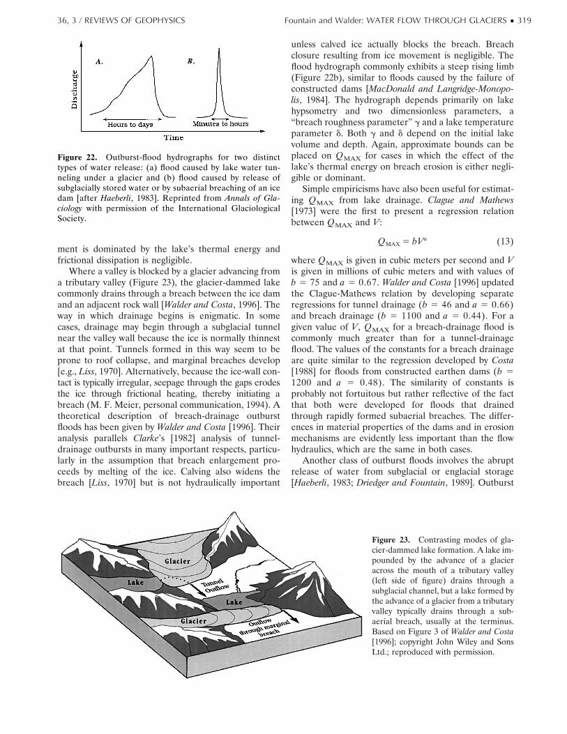
ment is dominated by the lake’s thermal energy andfrictional dissipation is negligible.
Where a valley is blocked by a glacier advancing froma tributary valley (Figure 23), the glacier-dammed lakecommonly drains through a breach between the ice damand an adjacent rock wall [Walder and Costa, 1996]. Theway in which drainage begins is enigmatic. In somecases, drainage may begin through a subglacial tunnelnear the valley wall because the ice is normally thinnestat that point. Tunnels formed in this way seem to beprone to roof collapse, and marginal breaches develop[e.g., Liss, 1970]. Alternatively, because the ice-wall con-tact is typically irregular, seepage through the gaps erodesthe ice through frictional heating, thereby initiating abreach (M. F. Meier, personal communication, 1994). Atheoretical description of breach-drainage outburstfloods has been given by Walder and Costa [1996]. Theiranalysis parallels Clarke’s [1982] analysis of tunnel-drainage outbursts in many important respects, particu-larly in the assumption that breach enlargement pro-ceeds by melting of the ice. Calving also widens thebreach [Liss, 1970] but is not hydraulically important
unless calved ice actually blocks the breach. Breachclosure resulting from ice movement is negligible. Theflood hydrograph commonly exhibits a steep rising limb(Figure 22b), similar to floods caused by the failure ofconstructed dams [MacDonald and Langridge-Monopo-lis, 1984]. The hydrograph depends primarily on lakehypsometry and two dimensionless parameters, a“breach roughness parameter” g and a lake temperatureparameter d. Both g and d depend on the initial lakevolume and depth. Again, approximate bounds can beplaced on QMAX for cases in which the effect of thelake’s thermal energy on breach erosion is either negli-gible or dominant.
Simple empiricisms have also been useful for estimat-ing QMAX from lake drainage. Clague and Mathews[1973] were the first to present a regression relationbetween QMAX and V:
QMAX 5 bVa (13)
where QMAX is given in cubic meters per second and Vis given in millions of cubic meters and with values ofb 5 75 and a 5 0.67. Walder and Costa [1996] updatedthe Clague-Mathews relation by developing separateregressions for tunnel drainage (b 5 46 and a 5 0.66)and breach drainage (b 5 1100 and a 5 0.44). For agiven value of V, QMAX for a breach-drainage flood iscommonly much greater than for a tunnel-drainageflood. The values of the constants for a breach drainageare quite similar to the regression developed by Costa[1988] for floods from constructed earthen dams (b 51200 and a 5 0.48). The similarity of constants isprobably not fortuitous but rather reflective of the factthat both were developed for floods that drainedthrough rapidly formed subaerial breaches. The differ-ences in material properties of the dams and in erosionmechanisms are evidently less important than the flowhydraulics, which are the same in both cases.
Another class of outburst floods involves the abruptrelease of water from subglacial or englacial storage[Haeberli, 1983; Driedger and Fountain, 1989]. Outburst
Figure 22. Outburst-flood hydrographs for two distincttypes of water release: (a) flood caused by lake water tun-neling under a glacier and (b) flood caused by release ofsubglacially stored water or by subaerial breaching of an icedam [after Haeberli, 1983]. Reprinted from Annals of Gla-ciology with permission of the International GlaciologicalSociety.
Figure 23. Contrasting modes of gla-cier-dammed lake formation. A lake im-pounded by the advance of a glacieracross the mouth of a tributary valley(left side of figure) drains through asubglacial channel, but a lake formed bythe advance of a glacier from a tributaryvalley typically drains through a sub-aerial breach, usually at the terminus.Based on Figure 3 of Walder and Costa[1996]; copyright John Wiley and SonsLtd.; reproduced with permission.
36, 3 / REVIEWS OF GEOPHYSICS Fountain and Walder: WATER FLOW THROUGH GLACIERS ● 319
floods of this type, which are by their nature unantici-pated and poorly described, seem to be triggered byrapid input of rain or meltwater to the glacier. Walderand Driedger [1995] suggested that the release mecha-nism probably involves unstable enlargement of the or-ifices in a basal cavity network that transforms into onethat drains water rapidly. This mechanism, initially pro-posed in connection with glacier-surge termination[Kamb, 1987], is also considered important to the annualreestablishment of an R channel network [cf. Nienow,1994; M. J. Sharp, personal communication, 1996]. Bore-hole measurements showing an abrupt reorganization ofthe basal drainage system, consistent with the scenariodiscussed here, have been collected at Trapridge Glacier[Stone and Clarke, 1996]. Alternatively, water could bestored englacially in passages temporarily isolated from thesubglacial drainage system, then released when rapid inputof water to the glacier forces reconnection with the bed.
Floods from internally stored water are largely unpre-dictable. Walder and Driedger [1995] used statisticalmethods to show that for South Tahoma Glacier (MountRainier, Washington State), which released 14 or 15floods during a 6-year period, the probability of a floodincreased as the input rate of water to the glacier (as rainor meltwater) increased. These results agree with theobservations of Warburton and Fenn [1994]. Unfortu-nately, a relationship of this sort developed for a partic-ular glacier is unlikely to be applicable elsewhere. Aphysically plausible, albeit crude, estimate of QMAX isnonetheless possible. Glaciological experience [e.g.,Haeberli, 1983; Walder and Driedger, 1995] suggests thatthe water volume released from storage during an out-burst flood is likely to be of a magnitude correspondingto a water layer ;10–100 mm thick over the entireglacier bed and that the release typically occurs during aperiod t equal to ;15–60 min, although sometimes aslong as a day [Warburton and Fenn, 1994]. Estimating thereleased water volume as the product of the glacier-bedarea A and equivalent water layer thickness d and as-suming a triangular exit hydrograph, we estimate
QMAX <2 Ad
t(14)
As an example, consider a small alpine glacier with A 51 km2. The base flow from such a glacier is probably ;1m3/s [e.g., Fountain, 1993]. From (14) we estimate anupper bound for QMAX of ;100 m3/s. Flood peaks ofthis magnitude can be extremely destructive in smallalpine drainage basins, particularly if the water floodstransform to debris flows [Driedger and Fountain, 1989;Walder and Driedger, 1995].
8. LINKS BETWEEN HYDROLOGYAND GLACIER DYNAMICS
8.1. Effect of Glacier-Surface MorphologyVariations in water input to a glacier should affect
basal water pressure. If water moves rapidly from the
glacier surface to the bed, a proposition that we examinein section 9, the water pressure in bed areas suppliedfrom the ablation zone should respond rapidly (probablywithin a few minutes to a few hours) to variations in thewater input at the surface. In contrast, water pressure inbed areas supplied from the accumulation zone shouldrespond slowly (probably on a timescale of days to aweek or more) to varying water input at the surface,owing to delayed transport through snow and firn. Achange in supply region from accumulation to ablationzone should therefore be reflected at the base of theglacier by a relatively sharp gradient in variations ofsubglacial water pressure. This may have important im-plications for glacier dynamics because the rate of gla-cier sliding is, in part, related to the effective pressure(ice pressure minus water pressure) at the base of theglacier [Iken and Bindschadler, 1986; Jansson, 1995]. Weexpect the sliding speed in the ablation zone to begreater than that in the accumulation zone during peakdiurnal melt periods but less when the melt rate is at aminimum. The ablation zone would then “pull” theaccumulation during midday, and the accumulation zonewould “push” the ablation zone during the night. Simi-larly, the ablation zone would move fastest during thefirst few days of a rainy period before the water perco-lated through the accumulation zone and slowest justafter the rain stopped. This scenario would be somewhatmodified if most of the surface water input were routeddirectly to subglacial channels. Not only do the channelsonly pressurize a small part of the bed, but during theirlargest development in midsummer the conduits mayonly be pressurized during a short time each day. Underthese conditions the accumulation zone may more orless constantly push the ablation zone. Because spatialvariations in glacier movement are smoothed by longi-tudinal stress-gradient coupling over a distance relatedto the glacier thickness [Kamb and Echelmeyer, 1986],differences in flow speed between the accumulation andablation zones caused by variations in water input shouldtend to increase with the length of the glacier.
8.2. Subglacial HydrologyA large body of data has accumulated suggesting a
link between variations in the basal drainage system andperturbations in glacier movement, but the physical na-ture of the coupling remains elusive. The best knownevidence suggesting the hydrology-dynamics link in-volves seasonal variations in glacier-surface velocity, firstobserved by Forbes [1846] at Mer de Glace, France.Generally, the surface velocity peaks in late spring toearly summer in the ablation area; in the accumulationarea the seasonal variation may be of the opposite phase.The usual interpretation [e.g., Hodge, 1974] is thatchanges in surface velocity are too large to be explainedby mass balance induced changes in applied stress andthat changes in surface velocity therefore reflect changesin sliding velocity. Such an interpretation requires cau-tion. Balise and Raymond [1985] showed theoretically
320 ● Fountain and Walder: WATER FLOW THROUGH GLACIERS 36, 3 / REVIEWS OF GEOPHYSICS
that the transfer of basal-velocity variations to the gla-cier surface is sensitively dependent on the length scaleof such variations. They concluded that broad-scale vari-ations in basal sliding should be reflected by similarlybroad-scale variations in surface speed but that verylocalized basal-velocity variations cannot be unambigu-ously resolved by glacier-surface observations.
A key point of contention has been whether slidingspeed is controlled primarily by the volume of storedwater or by basal water pressure. Hodge [1974] showedthat the surface speed of Nisqually Glacier, WashingtonState, peaked before the meltwater discharge from theglacier and also that the speed actually increasedthroughout the winter, even while meltwater dischargewas falling. He interpreted this to mean that slidingspeed was controlled by the amount of water stored atthe glacier bed, with the maximum storage occurringearly in the melt season before an efficient basal drain-age system had developed (in line with our discussion insection 5). In contrast, Iken et al. [1983] found that themaximum sliding speed coincided with times when theglacier surface was rising most rapidly, the surface risebeing thought to indicate water going into storage,rather than with the time of maximum surface elevation;they interpreted this to mean that sliding speed was afunction of subglacial water pressure rather than stor-age. Iken and Bindschadler [1986] subsequently showed acorrelation between velocity fluctuations and boreholewater pressures at Findelengletscher, and similar measure-ments have been made at Storglaciaren [Jansson, 1995].
Probably, the most detailed observations dealing withthe link between basal hydrology and glacier dynamicsare those from Columbia Glacier, a rapidly movingtidewater glacier [Meier et al., 1994; Kamb et al., 1994].Surface-velocity fluctuations at two sites 7 km apart werestrongly correlated with each other and fairly well cor-related with the borehole water level at the upglacier ofthe two sites but not with the borehole water level at thelower site. Using estimates for recharge to and dischargefrom the basal drainage system, Kamb et al. [1994] con-cluded that variations in ice velocity were best correlatedwith variations in the amount of water stored at theglacier bed.
We appear to be faced with a conundrum. Models ofthe basal-cavitation process [Lliboutry, 1968; Iken, 1981;Fowler, 1986, 1987; Kamb, 1987] predict an increase inbasal storage with an increase in basal water pressure,yet glacier movement seems sometimes to correlate withstorage, sometimes with water pressure, but not withboth. Kamb et al. [1994] suggested a resolution of thisconundrum, as follows: Glacier sliding speed ub andbasal storage are controlled by ^pw&, the basal waterpressure averaged over the distance l, the length scaleover which the basal shear stress is effectively averagedby glacier dynamics [Kamb and Echelmeyer, 1986]. Thebasal water pressure pw measured at a point, however, isthe sum of the spatial mean value ^pw& and a localfluctuating value p9w, where p9w is controlled by rapid,
local reorganization of the basal drainage system. Thusone expects ub to correlate with storage but not neces-sarily with local pw.
8.3. Glacier SurgingSurging glaciers exhibit [Raymond, 1987, p. 9121] “a
multi-year, quasi-periodic oscillation between extendedperiods of normal motion and brief periods of compar-atively fast motion.” A thorough review of glacier surg-ing is beyond the scope of this paper (we refer the readerto the review by Raymond [1987]), but we do want tohighlight recent developments related to the study of the1982–1983 surge of Variegated Glacier [Kamb et al.,1985; Humphrey et al., 1986; Kamb, 1987; Humphrey andRaymond, 1994] that point to regulation of the surgeprocess by basal water flow.
Kamb [1987] noted the following observations fromVariegated Glacier as the basis for his surge model:
1. Borehole measurements demonstrate directlythat rapid glacier motion during the surge is due to basalsliding.
2. Basal water pressure during the surge was closeto the overburden pressure and notably higher thanduring the nonsurging state. Peaks in water pressurecorresponded with peaks in sliding motion in both surg-ing and nonsurging states.
3. Major decreases in surge motion, as well as surgetermination, were accompanied by large flood peaks inoutlet streams and a lowering of the glacier surface,indicating that the high sliding speed and water pressureduring the surge are coupled with water storage withinand at the bed of the glacier.
4. Dye-tracing experiments [Brugman, 1986] showedthat the mean flow of water in the basal drainage systemwas ;25–30 times faster after surge termination thanduring the surge. Moreover, dye appeared at a numberof locations across the width of the glacier during thesurge, but in only a single stream after surge termina-tion.
5. Water discharged from the glacier during thesurge was extremely turbid; suspended-sediment con-centration was much higher, and the average grain sizeof suspended sediment was finer during the surge than inthe nonsurging phase [Humphrey and Raymond, 1994].
A physical model of surging that accounts for theseobservations was developed by Kamb [1987], who pro-posed that the basal drainage system during surge com-prised a linked-cavity network, whereas the drainagesystem during the nonsurging phase consisted of arbo-rescent R channels. The cavity system is associated withhigh water pressure and multiple, tortuous flow pathsleading to prolonged, highly dispersed dye returns.Surge slowdowns and surge termination result fromlarge transient increases in basal water pressure thatdestabilize part of the cavity system, thereby releasingwater from storage. Sediment concentration in the melt-water discharged from the glacier increased during thesurge because a linked-cavity drainage system brought a
36, 3 / REVIEWS OF GEOPHYSICS Fountain and Walder: WATER FLOW THROUGH GLACIERS ● 321
large fraction of the glacier bed into contact with flowingwater, but the mean suspended-sediment size droppedduring the surge because the sluggishly flowing water inthe cavity system could not suspend as much coarsesediment as could rapidly flowing, channelized water[Humphrey and Raymond, 1994].
The conditions that cause surge initiation can also beexplained, at least qualitatively, in the context of thechannel-cavity dichotomy. Raymond [1987] and Kamb[1987] suggested that during winter, R channels collapseand a high-pw linked-cavity network develops. Usually,as the melt season begins, the flux of meltwater to thebed causes water pressure transients that destabilizeparts of the linked-cavity network, and an R channelnetwork reforms. (We have suggested in section 5 thatthis scenario is probably common to all temperate gla-ciers, not just those that surge.) The stability of the cavitynetwork to pressure perturbations is controlled by aparameter J [Kamb, 1987] that depends on roughnesscharacteristics of the glacier bed, ice rheology, and gla-cier geometry; in a surging glacier, as the glacier geom-etry (primarily the thickness) changes with time duringthe nonsurging phase, a point is reached at which Jattains a small enough value to stabilize the wintertimecavity network against early melt-season water pressureperturbations. When this occurs, the high-pressurelinked-cavity system persists and enlarges, and surgingbegins. Complications in this scenario have been dis-cussed by Humphrey and Raymond [1994].
9. UNIFIED MODEL OF WATER FLOWTHROUGH A TEMPERATE GLACIER
Water enters the body of a glacier primarily throughcrevasses and moulins. The englacial drainage systemcomprises a complex combination of gently inclined pas-sages spawned by water flow along crevasse bottoms andsteeply inclined passages formed by water enlarging in-tergranular veins. In general, water flows englacially forlong distances, perhaps equal to several times the glacierthickness, before reaching the bed, although the com-mon presence of moulins in the ablation zone indicatesthat water can sometimes descend vertically through asignificant fraction of the ice thickness.
The englacial conduit system supplied from the accu-mulation zone is of relatively limited extent comparedwith the system supplied from the ablation zone becauseof the role of the firn in damping diurnal variations inwater input. Much of the water that enters the glacier inthe accumulation zone probably reaches the bed in theablation zone. Thus the subglacial area of influence ofeach zone is shifted downglacier, and the firn influencesa subglacial area greater than the area it actually covers.
The supply of surface water to the bed is inhibited inoverdeepened parts of the glacier because the gentlyinclined parts of the englacial conduit system becomepinned by the downglacier margin of the overdeepening.
Basal water flow in an overdeepening is essentially re-stricted to the water already in the basal drainage systemupglacier of the overdeepening; basal conduits may tendto freeze shut where they encounter the adverse slopecoming out of the overdeepening. Basal conduits shouldbe most frequently located along the margins of theoverdeepening.
The morphology of the subglacial drainage system iscontrolled by a number of factors, including the distri-bution of englacial conduits reaching the bed, ice thick-ness, glacier sliding speed, bed lithology, and bed rough-ness. Any one of these factors may be of relativelygreater or lesser importance at any particular glacier.Generally speaking, the morphology of the basal drain-age system is heterogeneous. Slow drainage systems,involving linked cavities, permeable till, and channelsegments incised into the bed and trending along the iceflow direction, cover most of the bed. The slow drainagesystem is in poor hydraulic communication with a fastsystem of R channels incised into the basal ice. The Rchannel system largely collapses during winter and isreformed in the spring as a flush of water reaches thebed and destabilizes parts of the linked-cavity network.In relatively thick ice, say, 200 m or more, there isprobably ample opportunity for englacial drainage tobecome concentrated into a relatively small number oftrunk conduits, each carrying a large water flux, whereasin thin ice, say, 50 m or less, the englacial flow isrelatively more diffuse, with a large number of englacialconduits, each carrying a small flux of water, reachingthe bed.
10. DIRECTIONS FOR FUTURE RESEARCH
Glaciologists need to adopt a holistic perspective instudying glacier hydrology. Indeed, although we havewritten separately about near-surface, englacial, andsubglacial water flow, the three phenomena are obvi-ously coupled. Influences in the glacier drainage systemnearly always move from the glacier surface downward.Forcings imposed on the englacial and subglacial pas-sages are distinctly different, depending on whether wa-ter is supplied from the accumulation zone or the abla-tion zone.
Coupling between the near-surface and englacialdrainage systems needs to be investigated much morethoroughly. There are almost no data available showinghow water flux to crevasses and moulins is distributedover the glacier surface and how this distribution evolvestemporally. These flux data constitute a fundamentalboundary condition for the englacial part of the drainagesystem.
The water flux delivered to the bed at the points ofcoupling between the englacial and subglacial drainagesystems constitutes the “upstream” boundary conditionon the subglacial drainage system. This flux distributionobviously cannot be directly measured, but it may still be
322 ● Fountain and Walder: WATER FLOW THROUGH GLACIERS 36, 3 / REVIEWS OF GEOPHYSICS
investigated once we recognize that surface water sup-plied to the englacial drainage system almost certainlybecomes concentrated into a relatively limited numberof trunk conduits by the time it reaches the glacier bed[Shreve, 1972]. It may be possible to use tracers todelineate the “drainage basins” of the englacial trunkconduits (i.e., the ones that reach the bed) and therebyto estimate the distribution of recharge to the subglacialdrainage system, much as tracers have been used todelineate the gross drainage-basin structure of entireglaciers [e.g., Stenborg, 1973; Fountain, 1992, 1993;Fountain and Vaughn, 1995].
Some of the theoretical foundations of glacier hydrol-ogy theory need to be revisited. Clarke [1994] has re-cently begun doing this for the case of Rothlisbergerchannels by critically examining one of the key simplify-ing assumptions (the neglect of heat advection by thewater) in Rothlisberger’s [1972] analysis. (At the time ofwriting, Clarke’s recent work has appeared only as anabstract, and we cannot assess it critically.) There is alsoa distinct need to understand how the drainage systemshould respond to time-varying water input. This topichas been touched upon by Spring [1980], who exploredthe pressure-discharge relation for sinusoidally varyingflow in R channels, and by Kamb [1987] in his analysis ofthe stability of cavities to pressure transients.
The time seems to be ripe for constructing theoreticalmodels that fully couple glacier sliding and basal hydrol-ogy, accounting properly for both the long-range spatialaveraging imposed by ice dynamics and the complex,time- and space-dependent variations within the basaldrainage system. Some important studies that we believecan jointly serve as a springboard are those of Humphrey[1987], Murray and Clarke [1995], and Clarke [1996].
Humphrey [1987] presented the only analysis to dateof the dynamic coupling between a glacier and its basaldrainage system, albeit within the context of a highlyidealized view of glacier-bed geometry. He argued that acomplete description of the coupling between subglacialwater flow and glacier dynamics requires one to specifythe following: (1) a force balance at the bed, (2) thecoupling between the basal shear stress and the stressesin the body of the glacier, with careful attention tolongitudinal stress gradients, (3) a relation between cav-ity size, sliding speed, and basal water pressure, and (4)a description of the hydraulics of water flow in the linkedcavities. The mathematical model is complicated, and itsconsequences have not yet been fully elucidated, but theresults are tantalizing. Most importantly, from the per-spective of glaciologically meaningful measurements,Humphrey showed that the model predicts no simplerelation between the variation in sliding speed and thevariation in water pressure as a function of distancealong the glacier, although variations in sliding speed arepredicted to correlate with basal water storage. Thesemodel predictions are in line with field data and inter-pretation from Columbia Glacier [Meier et al., 1994;Kamb et al., 1994].
Murray and Clarke [1995] developed a “black-box”model of the subglacial drainage system to explain pe-culiarities of the borehole water level data from Tra-pridge Glacier, but the concepts they developed aremore widely applicable. Murray and Clarke showed thatobserved, time-dependent coupling between connectedand unconnected boreholes could be modeled by think-ing of water pressure in a connected borehole as aforcing function to which water pressure in an uncon-nected borehole must respond. Although their mathe-matical formulation was somewhat ad hoc, they arguedplausibly that their model coefficients could be inter-preted in terms of physical processes at the glacier bed,namely, dilation/compaction of porous subglacial sedi-ment, diffusion of water pressure disturbances throughthe sediment, and uplift of the glacier from its bed.Subsequently, Clarke [1996] has shown that conceivingof the subglacial drainage system as consisting of linked“lumped elements,” analogous to an electrical circuit,provides a powerful basis for explaining many of thecomplicated data collected during ;25 years of boreholestudies. This approach seems to have great potential forelucidating the details of basal hydrology at relativelysmall spatial scales and short time periods. In this senseit complements Humphrey’s [1987] approach, which isdirected at explaining large-scale, long time period be-havior.
A key issue that needs much more thorough investi-gation is how the various components of the glacialdrainage system interact in space and time. The systemcomponents (snow, firn, and surface streams; crevasses,moulins, and other englacial passages; and basal chan-nels, cavities, and till) are in a state of flux throughoutthe year and are unevenly distributed.
GLOSSARY
Ablation: All forms of mass loss including sublima-tion, evaporation, melting, and calving. For alpine gla-ciers, the term “ablation” is often used, incorrectly, tomean melt because that is the dominant means of massloss.
Ablation zone: The part of the glacier where yearlymass loss exceeds that gained by snow accumulation andthe surface exposed in the late summer is ice.
Accumulation zone: The part of the glacier whereyearly mass gain generally exceeds that lost by ablationand the surface consists of either snow or firn.
Albedo: The ratio of reflected energy flux to inci-dent energy flux from solar radiation.
Arborescent: Tree like, used to describe a networkof channels that converge as the branches of a treeconverge to a trunk.
Confined aquifer: A water-bearing formation con-fined on the top and bottom by nearly impermeableformations.
36, 3 / REVIEWS OF GEOPHYSICS Fountain and Walder: WATER FLOW THROUGH GLACIERS ● 323
Crevasse: A gaping crack in a glacier formed bytensile stresses resulting from glacier movement.
Englacial: Within the body of a glacier.Equilibrium line: Line dividing the ablation and
accumulation zones, where net annual mass change iszero.
Firn: A metamorphic transition stage between snowand ice. By definition, firn is seasonal snow that hassurvived the summer melt season.
Glacierized: Landscape currently covered by gla-ciers.
Glaciated: Landscape once acted upon by glaciers.Hydraulic conductivity: A measure of the ability of
a porous medium to transmit fluids.Ice stream: Fast-moving (hundreds of meters per
year) river of ice within an otherwise slow-moving (tensof meters per year) ice sheet. Ice streams are found inAntarctica and Greenland.
Intergranular: Between the grains. Used here inconnection with veins to indicate small passages betweenthe grains (crystals) of ice, specifically at the boundarywhere three or more grains meet.
Moulin: A natural vertical shaft in the glacierformed from the heat of meltwater flowing into the bodyof the glacier.
Nonarborescent: Refers to a network that does notconverge from many flow paths to a few flow paths.Paths will converge and diverge with little or no changein the number of paths.
Overdeepening: A large depression in the bedrockunder a glacier. If the glacier receded, water would fillthe overdeepening to form a lake.
Subglacial: At the base of the glacier.Supraglacial: On the glacier surface.Surging glacier: A glacier that rapidly accelerates
its motion. These glaciers typically exhibit a cycle lastingdecades with quiescent “normal” flow (;0.1 m/d) inter-rupted by one or two seasons of rapid flow (tens ofmeters per day).
Temperate glacier: A glacier in which the temper-ature at the bed and within most of the body of the iceis at its melting point. Most glaciers in the temperatezones of the Earth are temperate glaciers. A polar gla-cier is one that is frozen to the bed and in whichmeltwater does not penetrate to significant depths.
Till: Unconsolidated sediment composed of silt,sand, and cobbles, formed by glacial erosion. As used inthis paper, the term does not have any sedimentologicalconnotations.
ACKNOWLEDGMENTS. This manuscript would nothave been possible without the insightful, candid discussionswe have had with many glaciologists over the years. We par-ticularly wish to thank M. Tranter, who originally motivatedthis project; M. J. Sharp and D. B. Stone, who carefullyreviewed an early version of this manuscript and helped usfocus our efforts; and G. K. C. Clarke and N. F. Humphrey,
who provided thoughtful reviews at a later stage. L. Faustassisted with the illustrations.
The Editor thanks Neil Humphrey and Garry Clarke fortechnical reviews.
REFERENCES
Alley, R. B., Water-pressure coupling of sliding and bed de-formation, I, Water system, J. Glaciol., 35, 108–118, 1989.
Alley, R. B., In search of ice stream sticky spots, J. Glaciol., 39,437–446, 1993.
Alley, R. B., Towards a hydrologic model for computerizedice-sheet simulations, Hydrol. Proc., 10, 649–660, 1996.
Alley, R. B., D. D. Blankenship, C. R. Bentley, and S. T.Rooney, Till beneath ice stream B, 3, Till deformation:Evidence and implications, J. Geophys. Res., 92, 8921–8929,1987.
Ambach, W., M. Blumthaler, H. Eisner, P. Kirchlechner,H. Scheider, H. Behrens, H. Moser, H. Oerter, W. Rauert,and H. Bergmann, Untersuchungen der Wassertafel amKesselwandferner (Otztaler Alpen) an einem 30 Metertiefen Firnschacht, Z. Gletscherkd. Glazialgeol., 14, 61–71,1978.
Ambach, W., M. Blumthaler, and P. Kirchlechner, Applicationof the gravity flow theory to the percolation of meltwaterthrough firn, J. Glaciol., 27, 67–75, 1981.
Anderson, R. S., B. Hallet, J. Walder, and B. F. Aubry, Ob-servations in a cavity beneath Grinnell Glacier, Earth Surf.Processes Landforms, 7, 63–70, 1982.
Bales, R. C., and R. F. Harrington, Recent progress in snowhydrology, U.S. Natl. Rep. Int. Union Geod. Geophys. 1991–1994, Rev. Geophys., 33, 1011–1020, 1995.
Balise, M. J., and C. F. Raymond, Transfer of basal slidingvariations to the surface of a linearly viscous glacier, J.Glaciol., 31, 308–318, 1985.
Behrens, H., H. Moser, H. Oerter, H. Bergmann, W. Ambach,H. Eisner, P. Kirchlechner, and H. Schneider, Neue Ergeb-nisse zur Bewegung des Schmelzwassers im Firnkorper desAkkumulationsgebietes eines Alpengletschers (Kessel-wandferner—Otztaler Alpen), Z. Gletscherkd. Glazialgeol.,15, 219–228, 1979.
Benson, C., W. Harrison, J. Gosink, S. Bowling, L. Mayo, andD. Trabant, Problems related to glacierized basins, Rep.UAG-R-306, Geophys. Inst., Univ. of Alaska, Fairbanks, 1986.
Bezinge, A., Glacial meltwater streams, hydrology and sedi-ment transport: The case of the Grande Dixence hydroelec-tricity scheme, in Glacio-fluvial Sediment Transfer, edited byA. M. Gurnell and M. J. Clark, 473–498, John Wiley, NewYork, 1981.
Bezinge, A., J. P. Perreten, and F. Schafer, Phenomenes du lacglaciaire du Gorner, in Symposium on the Hydrology ofGlaciers, IAHS Publ., 95, 65–78, 1973.
Bindschadler, R., The importance of pressurized subglacialwater in separation and sliding at the glacier bed, J. Glaciol.,29, 3–19, 1983.
Bjornsson, H., Explanation of jokulhlaups from Grımsvotn,Vatnajokull, Iceland, Joekull, 24, 1–26, 1974.
Bjornsson, H., Jokulhlaups in Iceland: Prediction, characteris-tics and simulation, Ann. Glaciol., 10, 95–106, 1992.
Blankenship, D. D., C. R. Bentley, S. T. Rooney, and R. B.Alley, Till beneath ice stream B, 1, Properties derived fromseismic travel times, J. Geophys. Res., 92, 8903–8912, 1987.
Boulton, G. S., and D. L. Dent, The nature and rates ofpost-depositional changes in recently deposited till fromsouth-east Iceland, Geogr. Ann., Ser. A, 56, 121–133, 1974.
Boulton, G. S., and R. C. A. Hindmarsh, Sediment deforma-tion beneath glaciers: Rheology and geological conse-quences, J. Geophys. Res., 92, 9059–9082, 1987.
324 ● Fountain and Walder: WATER FLOW THROUGH GLACIERS 36, 3 / REVIEWS OF GEOPHYSICS

Boulton, G. S., and A. S. Jones, Stability of temperate ice capsand ice sheets resting on beds of deformable sediment, J.Glaciol., 24, 29–43, 1979.
Boulton, G. S., D. L. Dent, and E. Morris, Subglacial shearingand crushing, and the role of water pressures in tills fromsouth-east Iceland, Geogr. Ann., Ser. A, 56, 135–145, 1974.
Brandt, R. E., and S. G. Warren, Solar-heating rates andtemperature profiles in Antarctic snow and ice, J. Glaciol.,39, 99–110, 1993.
Brugman, M. M., Water flow at the base of a surging glacier,Ph.D. dissertation, Calif. Inst. of Technol., Pasadena, Ca.,1986.
Clague, J. J., and W. H. Mathews, The magnitude ofjokulhlaups, J. Glaciol., 12, 501–504, 1973.
Clarke, G. K. C., Glacier outburst floods from “Hazard Lake,”Yukon Territory, and the problem of flood magnitude pre-diction, J. Glaciol., 28, 3–21, 1982.
Clarke, G. K. C., The trouble with R channels (abstract), EosTrans. AGU, 75(44), Fall Meet. Suppl., 222, 1994.
Clarke, G. K. C., Lumped-element analysis of subglacial hy-draulic circuits, J. Geophys. Res., 101, 17,547–17,559, 1996.
Colbeck, S. C., and E. A. Anderson, The permeability of amelting snow cover, Water Resour. Res., 18, 904–908, 1982.
Costa, J. E., Floods from dam failures, in Flood Geomorphol-ogy, edited by V. R. Baker, R. C. Kochel, and P. C. Patton,pp. 439–463, John Wiley, New York, 1988.
Cutler, P. M., Modelling the evolution of subglacial tunnelsdue to varying water input, J. Glaciol., in press, 1998.
Domenico, P. A., and F. W. Schwartz, Physical and ChemicalHydrogeology, John Wiley, New York, 1990.
Driedger, C. L., and A. G. Fountain, Glacier outburst floods atMount Rainier, Washington, Ann. Glaciol., 13, 51–55, 1989.
Echelmeyer, K., and W. D. Harrison, Jakobshavns Isbrae,West Greenland: Seasonal variations in velocity—or lackthereof, J. Glaciol., 36, 82–88, 1990.
Engelhardt, H., Water in glaciers: Observations and theory ofthe behaviour of water levels in boreholes, Z. Gletscherkd.Glazialgeol., 14, 35–60, 1978.
Engelhardt, H. F., W. D. Harrison, and B. Kamb, Basal slidingand conditions at the glacier bed as revealed by bore-holephotography, J. Glaciol., 20, 469–508, 1978.
Engelhardt, H., N. Humphrey, B. Kamb, and M. Fahnestock,Physical conditions at the base of a fast moving Antarcticice stream, Science, 248, 57–59, 1990.
Forbes, J. D., Illustrations of the viscous theory of glaciermotion, Philos. Trans. R. Soc. London, 136, 143–210, 1846.
Fountain, A. G., The storage of water in, and hydraulic char-acteristics of, the firn of South Cascade Glacier, Washing-ton State U.S.A., Ann. Glaciol., 13, 69–75, 1989.
Fountain, A. G., Subglacial water flow inferred from streammeasurements at South Cascade Glacier, WashingtonState, U.S.A., J. Glaciol., 38, 51–64, 1992.
Fountain, A. G., Geometry and flow conditions of subglacialwater at South Cascade Glacier, Washington State, U.S.A.,J. Glaciol., 39, 143–156, 1993.
Fountain, A. G., Borehole water-level variations and implica-tions for the subglacial hydraulics of South Cascade Glacier,Washington State, U.S.A., J. Glaciol., 40, 293–304, 1994.
Fountain, A. G., Effect of snow and firn hydrology on thephysical and chemical characteristics of glacial runoff, Hy-drol. Proc., 10, 509–521, 1996.
Fountain, A. G., and B. H. Vaughn, Changing drainage pat-terns within South Cascade Glacier, Washington, USA,1964–1992, in Biogeochemistry of Snow Covered Watersheds,edited by K. Tonnesson and M. Williams, IAHS Publ., 228,379–386, 1995.
Fountain, A. G., and J. S. Walder, Hydrology of glacial over-deepenings, paper presented at International Workshop on
Glacier Hydrology, Int. Glaciol. Soc., Cambridge, England,U.K., Sept., 1993.
Fowler, A. C., A sliding law for glaciers of constant viscosity inthe presence of subglacial cavitation, Proc. R. Soc. London,Ser. A, 407, 147–170, 1986.
Fowler, A. C., Sliding with cavity formation, J. Glaciol., 33,255–267, 1987.
Fowler, A., and J. S. Walder, Creep closure of channels indeforming subglacial till, Proc. R. Soc. London, Ser. A, 441,17–31, 1993.
Glazyrin, G. E., and L. N. Sokolov, Vozmozhnost’ prognozakharakteristik pavodkov, vyzyvaemykh proryvami lednik-ovykh ozer (Forecasting of flood characteristics caused byglacier lake outbursts), Materialy GlyatsiologicheskikhIssled., 26, 78–85, 1976.
Haeberli, W., Frequency and characteristics of glacier floods inthe Swiss Alps, Ann. Glaciol., 4, 85–90, 1983.
Hallet, B., The effect of subglacial chemical processes onglacier sliding, J. Glaciol., 17, 209–221, 1976.
Hallet, B., Subglacial regelation water film, J. Glaciol., 23,321–334, 1979.
Hallet, B., and R. S. Anderson, Detailed glacial geomorphol-ogy of a proglacial bedrock area at Castleguard Glacier,Alberta, Canada, Z. Gletscherkd. Glazialgeol., 16, 171–184,1980.
Hantz, D., and L. Lliboutry, Waterways, ice permeability atdepth and water pressures at Glacier d’Argentiere, FrenchAlps, J. Glaciol., 29, 227–239, 1983.
Harper, J. T., and N. F. Humphrey, Borehole video analysis ofa temperate glacier’s englacial and subglacial structure:Implications for glacier flow models, Geology, 23, 901–904,1995.
Hock, R., and R. L. Hooke, Evolution of the internal drainagesystem in the lower part of the ablation area of Storgla-ciaren, Sweden, Geol. Soc. Am. Bull., 105, 537–546, 1993.
Hodge, S. M., Variations in the sliding of a temperate glacier,J. Glaciol., 13, 349–369, 1974.
Hodge, S. M., Direct measurement of basal water pressures: Apilot study, J. Glaciol., 16, 205–218, 1976.
Hodge, S. M., Direct measurement of basal water pressures:Progress and problems, J. Glaciol., 23, 309–319, 1979.
Hooke, R. L., On the role of mechanical energy in maintainingsubglacial water conduits at atmospheric pressure, J. Gla-ciol., 30, 180–187, 1984.
Hooke, R. L., Positive feedbacks associated with erosion ofglacial cirques and overdeepenings, Geol. Soc. Am. Bull.,103, 1104–1108, 1991.
Hooke, R. L., and V. A. Pohjola, Hydrology of a segment of aglacier situated in an overdeepening, Storglaciaren, Swe-den, J. Glaciol., 40, 140–148, 1994.
Hooke, R. L., B. Wold, and J. O. Hagen, Subglacial hydrologyand sediment transport at Bondhusbreen, southwest Nor-way, Geol. Soc. Am. Bull., 96, 388–397, 1984.
Hooke, R. L., S. B. Miller, and J. Kohler, Character of theenglacial and subglacial drainage system in the upper partof the ablation area of Storglaciaren, Sweden, J. Glaciol.,117, 87–92, 1988.
Hooke, R. L., T. Laumann, and J. Kohler, Subglacial waterpressures and the shape of subglacial conduits, J. Glaciol.,36, 67–71, 1990.
Hubbard, B. P., M. J. Sharp, I. C. Willis, M. K. Nielsen, andC. C. Smart, Borehole water-level variations and the struc-ture of the subglacial hydrological system of Haut Glacierd’Arolla, Valais, Switzerland, J. Glaciol., 41, 572–583, 1995.
Humphrey, N. F., Coupling between water pressure and basalsliding in a linked-cavity hydraulic system, in The PhysicalBasis of Ice Sheet Modeling, edited by E. D. Waddington andJ. S. Walder, IAHS Publ., 170, 105–119, 1987.
Humphrey, N. F., and C. F. Raymond, Hydrology, erosion and
36, 3 / REVIEWS OF GEOPHYSICS Fountain and Walder: WATER FLOW THROUGH GLACIERS ● 325
sediment production in a surging glacier: Variegated Gla-cier, Alaska, J. Glaciol., 40, 539–552, 1994.
Humphrey, N., C. Raymond, and W. Harrison, Discharges ofturbid water during mini-surges of Variegated Glacier,Alaska, U.S.A., J. Glaciol., 32, 195–207, 1986.
Humphrey, N., B. Kamb, M. Fahnestock, and H. Engelhardt,Characteristics of the bed of the lower Columbia Glacier,Alaska, J. Geophys. Res., 98, 837–846, 1993.
Iken, A., Measurement of water pressure in moulins as part ofa movement study of the White Glacier, Axel HeibergIsland, Northwest Territories, Canada, J. Glaciol., 11, 53–58, 1972.
Iken, A., The effect of the subglacial water pressure on thesliding velocity of a glacier in an idealized numerical model,J. Glaciol., 27, 407–421, 1981.
Iken, A., and R. A. Bindschadler, Combined measurements ofsubglacial water pressure and surface velocity of Findelen-gletscher, Switzerland: Conclusions about drainage systemand sliding mechanism, J. Glaciol., 32, 101–119, 1986.
Iken, A., H. Rothlisberger, A. Flotron, and W. Haeberli, Theuplift of Unteraargletscher at the beginning of the meltseason—A consequence of water storage at the bed?, J.Glaciol., 29, 28–47, 1983.
Iken, A., K. Fabri, and M. Funk, Water storage and subglacialdrainage conditions inferred from borehole measurementson Gornergletscher, Valais, Switzerland, J. Glaciol., 42,233–248, 1996.
Iverson, N. R., P. Jansson, and R. L. Hooke, In-situ measure-ment of the strength of deforming subglacial till, J. Glaciol.,40, 497–503, 1994.
Jacobel, R., and C. Raymond, Radio echo-sounding studies ofenglacial water movement in Variegated Glacier, Alaska, J.Glaciol., 30, 22–29, 1984.
Jansson, P., Water pressure and basal sliding on Storglaciaren,northern Sweden, J. Glaciol., 41, 232–240, 1995.
Kamb, B., Glacier surge mechanism based on linked cavityconfiguration of the basal water conduit system, J. Geophys.Res., 92, 9083–9100, 1987.
Kamb, B., Rheological nonlinearity and flow instability in thedeforming bed mechanism of ice stream motion, J. Geophys.Res., 96, 16,585–16,595, 1991.
Kamb, B., and K. A. Echelmeyer, Stress-gradient coupling inglacier flow, I, Longitudinal averaging of the influence ofice thickness and surface slope, J. Glaciol., 32, 267–284,1986.
Kamb, B., C. Raymond, W. Harrison, H. Engelhardt, K. Ech-elmeyer, N. Humphrey, M. Brugman, and T. Pfeffer, Gla-cier surge mechanism: 1982–1983 surge of VariegatedGlacier, Alaska, Science, 227, 469–479, 1985.
Kamb, B., H. Engelhardt, M. A. Fahnestock, N. Humphrey,M. Meier, and D. Stone, Mechanical and hydrologic basisfor the rapid motion of a large tidewater glacier, 2, Inter-pretation, J. Geophys. Res., 99, 15,231–15,244, 1994.
Kawashima, K., T. Yamada, and G. Wakahama, Investigationsof internal structure and transformational processes fromfirn to ice in a perennial snow patch, Ann. Glaciol., 18,117–122, 1993.
Kohler, J., Determining the extent of pressurized flow beneathStorglaciaren, Sweden using results of tracer experimentsand measurements of input and output discharge, J. Gla-ciol., 41, 217–231, 1995.
Lang, H., and G. Dyer, Switzerland case study: Water supply,in Techniques for Prediction of Runoff From GlacierizedBasins, edited by G. Young, IAHS Publ., 149, 45–57, 1985.
Lang, H., B. Schadler, and G. Davidson, Hydroglaciologicalinvestigations on the Ewigschneefeld–Gr. Aletschgletscher,Z. Gletscherkd. Glazialgeol., 12, 109–124, 1977.
Larson, G. J., Internal drainage of stagnant ice: Burroughs
Glacier, southeast Alaska, Rep. 65, 33 pp., Inst. of PolarStud., Ohio State Univ., Columbus, 1977.
Larson, G. J., Meltwater storage in a temperate glacier: Bur-roughs Glacier, southeast Alaska, Rep. 66, 56 pp., Inst. ofPolar Stud., Ohio State Univ., Columbus, 1978.
Lawson, D. E., Glaciohydrologic and glaciohydraulic effects onrunoff and sediment yield in glacierized basins, Monogr.93-2, 108 pp., Cold Reg. Res. and Eng. Lab., U.S. ArmyCorps of Eng., Hanover, N. H., 1993.
Liss, C.-C., Der Morenogletscher in der Patagonischen Kor-dillere: Sein ungewohnliches Verhalten seit 1889 und derEisdamm-Durchbruch des Jahres 1966, Z. Gletscherkd. Gla-zialgeol., 6, 161–180, 1970.
Lliboutry, L., Traite de Glaciologie, vol. 2, pp. 647–652, Mas-son, Paris, 1965.
Lliboutry, L., General theory of subglacial cavitation and slid-ing of temperate glaciers, J. Glaciol., 7, 21–58, 1968.
Lliboutry, L., Permeability, brine content and temperature oftemperate ice, J. Glaciol., 10, 15–30, 1971.
Lliboutry, L., Physical processes in temperate glaciers, J. Gla-ciol., 16, 151–158, 1976.
Lliboutry, L., Glissement d’un glacier sur un plan parsemed’obstacles hemispheriques, Ann. Geophys., 34, 147–162,1978.
Lliboutry, L., Local friction laws for glaciers: A critical reviewand new openings, J. Glaciol., 23, 67–95, 1979.
Lliboutry, L., Modifications to the theory of intraglacial water-ways for the case of subglacial ones, J. Glaciol., 29, 216–226,1983.
Lliboutry, L., Temperate ice permeability, stability of waterveins and percolation of internal meltwater, J. Glaciol., 42,201–211, 1996.
MacDonald, T. C., and J. Langridge-Monopolis, Breachingcharacteristics of dam failures, J. Hydraul. Eng., 110, 567–586, 1984.
Male, D. H., and D. M. Gray, Handbook of Snow, 776 pp.,Pergamon, Tarrytown, N. Y., 1981.
Mathews, W. H., Water pressure under a glacier, J. Glaciol., 5,235–240, 1964.
Mathews, W. H., and J. R. Mackay, Deformation of soils byglacier ice and the influence of pore pressure and perma-frost, Trans. R. Soc. Can., 54, 27–36, 1960.
Mayo, L. R., Advance of Hubbard Glacier and 1986 outburstof Russell Fiord, Alaska, U.S.A., Ann. Glaciol., 13, 189–194, 1989.
Meier, M. F., and A. Post, Recent variations in mass netbudgets of glaciers in western North America, in Variationsof the Regime of Existing Glaciers, IAHS Publ., 58, 63–77,1962.
Meier, M. F., and W. V. Tangborn, Net budget and flow ofSouth Cascade Glacier, Washington, J. Glaciol., 5, 547–566,1965.
Meier, M., S. Lundstrom, D. Stone, B. Kamb, H. Engelhardt,N. Humphrey, W. W. Dunlap, M. Fahnestock, R. M. Krim-mel, and R. Walters, Mechanical and hydrologic basis forthe rapid motion of a large tidewater glacier, 1, Observa-tions, J. Geophys. Res., 99, 15,219–15,229, 1994.
Murray, T., and G. K. C. Clarke, Black-box modeling of thesubglacial water system, J. Geophys. Res., 100,10,231–10,245, 1995.
Nienow, P., Dye-tracer investigations of glacier hydrologicalsystems, Ph.D. dissertation, Univ. of Cambridge, Cam-bridge, England, 1994.
Nye, J. F., The flow law of ice from measurements in glaciertunnels, laboratory experiments and the Jungfraufirn bore-hole experiment, Proc. R. Soc. London, Ser. A, 219, 477–489, 1953.
Nye, J. F., Glacier sliding without cavitation in a linear viscous
326 ● Fountain and Walder: WATER FLOW THROUGH GLACIERS 36, 3 / REVIEWS OF GEOPHYSICS
approximation, Proc. R. Soc. London, Ser. A, 315, 381–403,1970.
Nye, J. F., Water at the bed of a glacier, in Symposium on theHydrology of Glaciers, IAHS Publ., 95, 189–194, 1973.
Nye, J. F., Water flow in glaciers: Jokulhlaups, tunnels andveins, J. Glaciol., 17, 181–207, 1976.
Nye, J. F., and F. C. Frank, Hydrology of the intergranularveins in a temperate glacier, in Symposium on the Hydrologyof Glaciers, IAHS Publ., 95, 157–161, 1973.
Oerter, H., and H. Moser, Water storage and drainage withinthe firn of a temperate glacier (Vernagtferner, Oetztal Alps,Austria), in Hydrological Aspects of Alpine and High-Moun-tain Areas, IAHS Publ., 138, 71–81, 1982.
Ostling, M., and R. L. Hooke, Water storage in Storglaciaren,Kebnekaise, Sweden, Geogr. Ann., A68, 279–290, 1986.
Paterson, W. S. B., Physics of Glaciers, 3rd ed., 480 pp., Per-gamon, Tarrytown, N. Y., 1994.
Pohjola, V. A., TV-video observations of englacial voids inStorglaciaren, Sweden, J. Glaciol., 40, 231–240, 1994.
Raymond, C. F., How do glaciers surge? A review, J. Geophys.Res., 92, 9121–9134, 1987.
Raymond, C. F., and W. D. Harrison, Some observations onthe behavior of the liquid and gas phases in temperateglacier ice, J. Glaciol., 71, 213–234, 1975.
Raymond, C. F., R. J. Benedict, W. D. Harrison, K. A. Ech-elmeyer, and M. Sturm, Hydrological discharges and mo-tion of Fels and Black Rapids Glaciers, Alaska, USA:Implications for the structure of their drainage systems, J.Glaciol., 41, 290–304, 1995.
Rothlisberger, H., Water pressure in intra- and subglacialchannels, J. Glaciol., 11, 177–203, 1972.
Rothlisberger, H., and H. Lang, Glacial hydrology, in Glacio-fluvial Sediment Transport, edited by A. M. Gurnell andM. J. Clark, pp. 207–284, John Wiley, New York, 1987.
Rothlisberger, H., A. Iken, and U. Spring, Piezometric obser-vations of water pressure at the bed of Swiss glaciers (ab-stract), J. Glaciol., 23, 429, 1979.
Schneider, T., Water movement and storage in the firn ofStorglaciaren, northern Sweden, Stockholm Univ. Forskn-ingsrapport 99, 89 pp., Stockholm Univ., Stockholm, Swe-den, 1994.
Schommer, P., Wasserspiegelmessungen im Firn des Ewig-schneefeldes (Schweizer Alpen) 1976, Z. Gletscherkd. Gla-zialgeol., 12, 125–141, 1977.
Schommer, P., Rechnereische Nachbildung von Wasser-spiegelganglinien im Firn und Vergleich mit Feldmessun-gen im Ewigschneefeld (Schweizer Alpen), Z. Gletscherkd.Glazialgeol., 14, 173–190, 1978.
Seaberg, S. Z., J. Z. Seaberg, R. L. Hooke, and D. W. Wiberg,Character of the englacial and subglacial drainage system inthe lower part of the ablation area of Storglaciaren, Swe-den, as revealed by dye trace studies, J. Glaciol., 34, 217–227, 1988.
Shabtaie, S., I. M. Whillians, and C. R. Bentley, The morphol-ogy of ice streams A, B, and C, West Antarctica, and theirenvirons, J. Geophys. Res., 92, 8865–8884, 1987.
Sharp, M. J., J. C. Gemmell, and J. Tison, Structure andstability of the former drainage system of the Glacier deTsanfleuron, Switzerland, Earth Surf. Processes Landforms,14, 119–134, 1989.
Sharp, M. J., K. Richards, I. Willis, N. Arnold, P. Nienow,W. Lawson, and J. Tison, Geometry, bed topography anddrainage system of the Haut Glacier d’Arolla, Switzerland,Earth Surf. Processes Landforms, 18, 557–571, 1993a.
Sharp, M. J., I. C. Willis, B. Hubbard, M. Nielsen, G. Brown,M. Tranter, and C. Smart, Borehole water quality profiling:Explaining water level variations in boreholes, paper pre-sented at International Workshop on Glacier Hydrology,Int. Glaciol. Soc., Cambridge, England, Oct. 8–10, 1993b.
Shreve, R. L., Movement of water in glaciers, J. Glaciol., 11,205–214, 1972.
Shreve, R. L., Esker characteristics in terms of glacier physics,Katahdin esker system, Maine, Geol. Soc. Am. Bull., 96,639–646, 1985.
Shumskii, P. A., Principles of Structural Glaciology, translatedfrom Russian by D. Krauss, 491 pp., Dover, Mineola, N. Y.,1964.
Spring, U., Intraglazialer Wasserabfluss: Theorie und Modell-rechnungen, Mitt. 48, 197 pp., Versuchsanst. fur Wasserbau,Hydrol. und Glazial., Zurich, Switzerland, 1980.
Spring, U., and K. Hutter, Numerical studies of jokulhlaups,Cold Reg. Sci. Technol., 4, 221–244, 1981.
Stenborg, T., Some viewpoints on the internal drainage ofglaciers, in Hydrology of Glaciers, IAHS Publ., 95, 117–129,1973.
Stone, D. B., and G. K. C. Clarke, Estimation of subglacialhydraulic properties from induced changes in basal waterpressure: A theoretical framework for borehole responsetests, J. Glaciol., 39, 327–340, 1993.
Stone, D. B., and G. K. C. Clarke, In situ measurements ofbasal water quality and pressure as an indicator of thecharacter of subglacial drainage systems, Hydrol. Proc., 10,615–628, 1996.
Stone, D. B., M. F. Meier, K. J. Lewis, and J. T. Harper,Drainage configuration and scales of variability in the sub-glacial water system (abstract), Eos Trans. AGU, 75(44),Fall Meet. Suppl., 22, 1994.
Stone, D. B., G. K. C. Clarke, and R. G. Ellis, Inversion ofborehole-response test data for estimation of subglacialhydraulic properties, J. Glaciol., 43, 103–113, 1997.
Sturm, M., Observations on the distribution and characteristicsof potholes on surging glaciers, J. Geophys. Res., 92, 9015–9022, 1987.
Tangborn, W. V., R. Krimmel, and M. Meier, A comparison ofglacier mass balance by glaciological, hydrological, andmapping methods, South Cascade Glacier, Washington, inGeneral Assembly of Moscow, IAHS Publ., 104, 185–196,1975.
Taylor, P. L., A hot water drill for temperate ice, in Ice DrillingTechnology, edited by G. Holdsworth, K. C. Kuivinen, andJ. H. Rand, Spec. Rep. 84-34, 55 pp., U.S. Army Cold Reg.Res. and Eng. Lab., Hanover, N. H., 1984.
Vivian, R. A., and J. Zumstein, Hydrologie sous-glaciaire auglacier d’Argentiere (Mont-Blanc, France), in Symposiumon the Hydrology of Glaciers, IAHS Publ., 95, 53–64, 1973.
Waddington, B. S., and G. K. C. Clarke, Hydraulic propertiesof subglacial sediment determined from mechanical re-sponse of water-filled boreholes, J. Glaciol., 41, 112–124,1995.
Waitt, R. B., Jr., Case for periodic, colossal jokulhlaups fromPleistocene Lake Missoula, Geol. Soc. Am. Bull., 96, 1271–1286, 1985.
Walder, J. S., Stability of sheet flow of water beneath temper-ate glaciers and implications for glacier surging, J. Glaciol.,28, 273–293, 1982.
Walder, J. S., Hydraulics of subglacial cavities, J. Glaciol., 32,439–445, 1986.
Walder, J. S., and J. E. Costa, Outburst floods from glacier-dammed lakes: The effect of mode of lake drainage onflood magnitude, Earth Surf. Processes Landforms, 21, 701–723, 1996.
Walder, J. S., and C. L. Driedger, Frequent outburst floodsfrom South Tahoma Glacier, Mount Rainier, U.S.A.: Re-lation to debris flows, meteorological origin and implica-tions for subglacial hydrology, J. Glaciol., 41, 1–10, 1995.
Walder, J. S., and A. Fowler, Channelized subglacial drainageover a deformable bed, J. Glaciol., 40, 3–15, 1994.
36, 3 / REVIEWS OF GEOPHYSICS Fountain and Walder: WATER FLOW THROUGH GLACIERS ● 327

Walder, J., and B. Hallet, Geometry of former subglacial waterchannels and cavities, J. Glaciol., 23, 335–346, 1979.
Warburton, J., and C. R. Fenn, Unusual flood events from anAlpine glacier: Observations and deductions on generatingmechanisms, J. Glaciol., 40, 176–186, 1994.
Weertman, J., Catastrophic glacier advances, in Symposium ofObergurgl, edited by W. Ward, IAHS Publ., 58, pp. 31–39,1962.
Weertman, J., The theory of glacier sliding, J. Glaciol., 3,287–303, 1964.
Weertman, J., Effect of a basal water layer on the dimensionsof ice sheets, J. Glaciol., 6, 191–207, 1966.
Weertman, J., Water lubrication mechanism of glacier surges,Can. J. Earth Sci., 6, 929–942, 1969.
Weertman, J., Velocity at which liquid-filled cracks move in theEarth’s crust or in glaciers, J. Geophys. Res., 76, 8544–8553,1971.
Weertman, J., General theory of water flow at the base of aglacier or ice sheet, Rev. Geophys., 10, 287–333, 1972.
Willis, I. C., M. J. Sharp, and K. S. Richards, Studies of thewater balance of Midtdalsbreen, Hardangerjokulen, Nor-way, II, Water storage and runoff prediction, Z.Gletscherkd. Glazialgeol., 27/28, 117–138, 1991/1992.
A. G. Fountain, Department of Geology, Portland StateUniversity, 17 Cramer Hall, 1721 Southwest Broadway, Port-land, OR 97207-0751. (e-mail: [email protected])
J. S. Walder, U.S. Geological Survey, Cascades VolcanoObservatory, 5400 MacArthur Boulevard, Vancouver, WA98661. (e-mail: [email protected])
328 ● Fountain and Walder: WATER FLOW THROUGH GLACIERS 36, 3 / REVIEWS OF GEOPHYSICS