Embed Size (px)
Citation preview

STATE OF WASHINGTON DEPARTMENT OF NATURAL RESOURCES
BRIAN J. BOYLE, Commissioner of Public Lands JAMES A. STEARNS, Department Supervisor
DIVISION OF GEOLOGY AND EARTH RESOURCES Raymond Lasmanis, State Geologist
THE 1985 GEOTHERMAL GRADIENT
DRILLING PROJECT FOR THE STATE
OF WASHINGTON
by
Brent Barnett
State of Washington Department of Natural Resources
Division of Geology and Earth Resources
Open File Report 86-2
Prepared under U.S. Department of Energy Contract No. DE-AC07-79ET27014
for Assessment of Geothermal Resources in Washington
February, 1986


CONTENTS
Introduction • . . . . . . . . . . . . . . . . . . . . . . . . . . . . . . . . . . . . . . . . . . . . . . . . . . . . . Page 1
Procedures. . . . . . . . . . . . . . . . . . . . . . . . . . . . . . . . . . . . . . . . . . . . . . . . . . . . . . . . 4
Results . ........................ • . . . . . . . . . . . . . . . . . . . . . . . . . . . . . . . . . 5
Orr Creek, DNR85-1 C........................................... 7
Trout Creek, DNR85-7C......................................... 9
Spud Hill, DNR85-2.. . . . . . . . . . . . . . . . . . . . . . . . . . . . . . . . . . . . . . . . . . . 11
Midway, DNR85-3 •••••••.•.•.••••••••.••••••••••••••••••..•.•••• 11
Mount Adams SE, DNR85-4. • • • • • • • • • • • • • • • • • • • • • • • • • • • • • • • • • • • • • • 1 3
Bear Spring, DNR85-5... . . . . . . . • . . . . . . . . . . . . . . . . . . . . . . . . . . . . . 1 3
West Crater, DNR85-6. . . . . . . . . . . . . . • . . . . . . . . . . . . . . . . . . . . . . . . . . . 1 4
Heat Flow ....... w•••••••••••••••• ................................. References . .............................................. .
Appendix A - Lithologic Logs for 1985 Geothermal Gradient Test Holes •••
Appendix B - Temperature-Depth Data for 1985
....................
14
1 6
17
Geothermal Gradient Test Holes.................... 28
List of Figures
Figure 1985 Geothermal Test Hole Location Map ••••••••••••••••• 2
Figure 2 - Schematic diagram of a completed geothermal gradient test hole.............................................. 6
Figure 3 - Temperature Depth Curves for Orr Creek (DNR85-1C) and Trout Creek (DNR85-7C) ••••••••••••••••••••••••••••••••• 10
Figure 4 - Temperature Depth Curves for the five shallow holes; Spud Hill (DNR85-2), Midway (DNR85-3), Mount Adams SE (DNR85-4), Bear Spring (DNR85-5), and West Crater (DNR85-6) ••••••••••••••••.•••••••..•••••••••••.••••...• 1 2
List of Tables
Table 1 Summary of parameters for 1985 geothermal gradient
test holes •••••.••..•..•.. . . . . . . . . . . . . . . . . . . . . . . . . . . . . 8
-i-


INTRODUCTION
During the Summer and Fall of 1985, the Washington Division of Geology
and Earth Resources drilled seven geothermal gradient test holes in the
southern Washington Cascade Mountains. The project was a continuation of the
state-coupled U.S. Department of Energy Geothermal Resource Program drilling
which began in Washington State in 1979.
The locations of the 1985 drill holes are shown in Figure 1. Drill
sites were chosen with two primary objectives in mind: (1) to more accurately
define the general extent of potential geothermal resources in the southern
Washington Cascades, and (2) to evaluate specific targets that are geologi
cally and structurally favorable for the occurrence of geothermal resources.
Recent studies of ages and volumes of Quaternary volcanic rocks in south
ern Washington (Hammond and Korosec, 1983) suggest the existence of belts or
zones of concentrated Quaternary volcanism. Figure 1 shows the approximate
inferred boundaries of three of these zones: the Mount St. Helens, Indian
Heaven and Mount Adams zones. In past projects, drilling within the Mount
St. Helens and Indian Heaven zones has shown that local areas of high heat
flow and high geothermal gradients do indeed exist, but their regional
extent is indeterminate (Schuster and others, 1978; Korosec, 1983).
The Orr Creek drill hole (DNR85-1C) was spudded just outside the western
boundary of the Mount Adams zone, and approximately 1/8-mile south of the
Orr Creek Warm Springs. Water from these springs was analyzed in 1979 and
indicate equilibrium reservoir temperatures ranging from 78°C to as high as
231°c, depending on which geothermometer is considered (Korosec and others,
1980). The Spud Hill hole (DNR85-2) was drilled 1;2-mile east of two late
Quaternary cinder cones, near what is believed to be a possible northern
-1-
122°
LEWIS CO.
SKAMANIA CO. 5 ... 0 ......
\ \ * Mt. St. Helens
\
\ \ \ \
\ IND;AN \ \ * Mt. Adams
* \MT.ADAM~
J\ COWLITZ CO. \ * \
,~ t \ \I ZONE ... \A HEAVEN \ * \
\MT. ST. HELENS \ t : * YAKIMA CO.
* ... B KLICKITAT co. \ zoNr.\
\ * \ \ ... tv \
\ t * ! \ 46°
\
ZONE~ \ \ CLARK CO.
* * \ * \* * ~
\ ! ... T \ \*
8 0 5 10 15 miles
.6. • GEOTHERMAL GRADIENT TEST HOLE:
s . SPUD HILL B . BEAR SPRING
Q · ORR CREEK
M- MIDWAY
W · WEST CRATER
T . TROUT CREEK
* · QUATERNARY VOLCANIC VENT
A . MT. ADAMS SE *. MAJOR QUATERNARY STRATOVOLCANO
1985 GEOTHERMAL TEST HOLE
LOCATION MAP
WASHINGTON STATE DEPARTMENT OF NATURAL RESOURCES
DIVISION OF GEOLOGY AND EARTH RESOURCES
122°
Figure 1. Locations of geothermal gradient test holes drilled during 1985 by the Division of Geology and Earth Resources, showing the volcanic zones of Mount St. Helens, Indian Heaven, and Mount Adams (see text for discussion). Asterisks represent individual Quaternary volcanic vents, or the averaged position of a cluster of vents (zone boundaries adapted from Hammond and Korosec, 1983).
2
extension of the Indian Heaven zone. The Midway hole (DNR85-3) lies within
the Mount Adams zone near Potato Hill, a late Quaternary basaltic andesite
vent (Hammond and Korosec, 1983). Mount Adams SE (DNR85-4) was drilled
within the Mount Adams zone about 1,1,~-mile north of the volcanic vent which
produced the basalt of County Park, K-Ar dated at about 200,000 years old
(Hammond and Korosec, 1983). Bear Spring (DNR85-5) lies barely within the
interpreted eastern boundary of the Indian Heaven zone, about 3/4-mile
south of Flattop Mountain, another Quaternary basalt vent.
The final two holes of the 1985 project, West Crater (DNR85-6) and Trout
Creek (DNR85-7C), were drilled within the southern part of the Mount St.
Helens zone, along a northwest-southeast-trending lineament called the Wind
River zone (Berri and Korosec, 1983). The structure is probably a fault,
and is roughly demarcated by the course of the Wind River, a line of Tertiary
intrusives, Quaternary volcanic vents, and the occurrence of mineral springs
and hot springs. The 1985 Trout Creek hole is located along the Wind River
zone, and is a twin to a 152-meter hole drilled by the Division of Geology
in 1981 (Korosec, 1983). The main reason for drilling deeper at this location
was to determine if the very high gradient of 84°C/km measured in the earlier
hole would persist with depth. The West Crater hole is located northwest of
the Trout Creek hole amid a concentration of Quaternary eruptive centers
ranging in composition from high alumina basalt to andesite. Hammond (per
sonal communication) has suggested that at least three of the vents in the
area are of Holocene age, with the West Crater volcano being as young as
5,000 years.
-3-
PROCEDURES
Two categories of hole depths were selected for the 1985 project: Orr
Creek (DNR85-1C) and Trout Creek (DNR85-7C) were to be drilled to 400 m,
and the remaining five holes, Spud Hill (DNR85-2), Midway (DNR85-3), Mount
Adams SE (DNR85-4), Bear Spring (DNR85-5) and West Crater (DNR85-6), were
targeted for 150 m. The deep holes, Orr Creek and Trout Creek, and two of
the shallow holes, Midway and Mount Adams SE, were finished somewhat short
of the target depths due to hole problems and budget constraints.
Two drilling methods were used: Orr Creek and Trout Creek were diamond
drilled using a wireline coring assembly, while the five shallow holes were
drilled by down-hole air hammer. The drilling and hole completions re~uired
slightly more than two months to complete.
Overburden was penetrated by driving 6-inch surface casing by air hammer
in shallow holes, or in the case of the deep core holes, overburden was
drilled using 5-inch casing bits that remained in the hole after completion.
Once the overburden was penetrated, the surface casing was cemented and
drilling of the hole resumed.
The Spud Hill, Midway, Mount Adams SE, Bear Spring, and West Crater
holes were drilled with a 6-inch air hammer to total depths, with cutting
samples collected every five feet. Orr Creek and Trout Creek were drilled
with H-sized diamond coring bits to about the 150-meter level in each hole.
Below 150 meters, both holes were reduced to NX-size. During the drilling
of the two deep holes, return-line mud temperatures were monitored hourly
as a precaution against possible blowout. When conditions permitted, bottom
hole temperatures were recorded in the core holes just prior to the beginning
of drilling each morning. Temperature-depth plots of these bottom-hole temp
eratures gave early and accurate estimates of the geothermal gradients.
-4-
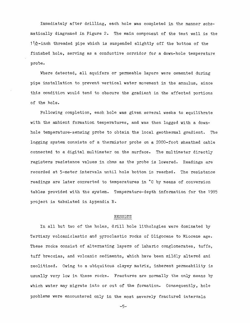
Immediately after drilling, each hole was completed in the manner sche
matically diagramed in Figure 2. The main component of the test well is the
11k-inch threaded pipe which is suspended slightly off the bottom of the
finished hole, serving as a conductive corridor for a down-hole temperature
probe.
Where detected, all aquifers or permeable layers were cemented during
pipe installation to prevent vertical water movement in the annulus, since
this condition would tend to obscure the gradient in the affected portions
of the hole.
Following completion, each hole was given several weeks to equilibrate
with the ambient formation temperatures, and was then logged with a down
hole temperature-sensing probe to obtain the local geothermal gradient. The
logging system consists of a thermistor probe on a 2000-foot sheathed cable
connected to a digital multimeter on the surface. The multimeter directly
registers resistance values in ohms as the probe is lowered. Readings are
recorded at 5-meter intervals until hole bottom is reached. The resistance
readings are later converted to temperatures in °C by means of conversion
tables provided with the system. Temperature-depth information for the 1985
project is tabulated in Appendix B.
RESULTS
In all but two of the holes, drill hole lithologies were dominated by
Tertiary volcaniclastic and pyroclastic rocks of Oligocene to Miocene age.
These rocks consist of alternating layers of laharic conglomerates, tuffs,
tuff breccias, and volcanic sediments, which have been mildly altered and
zeolitized. Owing to a ubiquitous clayey matrix, inherent permeability is
usually very low in these rocks. Fractures are normally the only means by
which water may migrate into or out of the formation. Consequently, hole
problems were encountered only in the most severely fractured intervals
-5-

GEOTHERMAL GRADIENT
TEST WELL CONSTRUCTION
lYi" PIPE WELDED TO SURFACE CASING FOR SUSPENSION
, .... ~~.:· • . o: .. ::,,-.....: : . ·•.· ~LJL-bCJ 'b·•:L/o· O·•o tll;lifJ~t~i~:o ¢,tPQ6~DeJ.·:.t;;~·· '.l:>qo '9d:e5r.:5Q6:ii.~r: O· . c;::,' (/t:,·2:::)~CJ O o·-o·· •·C)·
0"
'.c;>~~<J(1g'./f_c"//f;)E,;}~[ ... /,,.,,,, ,, ,,. 'j: 0 P;p OVERBURDENE>O::,
SURFACE CASING SEAL (CEMENT)
BEDROCK
1Y," BLACK IRON PIPE SUSPENDED IN HOLE AND FILLED WITH WATER
HOLE SIZE REDUCTION ---
BACKFILL
~'?~~~.!o::~.§ 3)/~a • t0°q,0;
HINGED, LOCKING WELL COVER ~ · •/ . .. .,,. __ ,··=··- .. v/go· .,_. ·. -• -17.v-v_• q, •. o .. -':",'~ ~Q,:;,. ·-·10· "'<'111•·•·Q•:~"."d Oc:j·••c:i 0 "-:'o ...,..,.,. ..... _,,<Y-~O .. :'Q._;'f!;i:i~.(). 9Q a_ a.·o~o··
'./,i""'4··.;: ~~iif~~1%:~g}}R~r f ,s:·: :~ .,·:-:··-~:o·,c:)"·:::<:...)"il<l""""""".U:o- ·o· =o ...•. ·,c····a··o<?·oo· .· . QC,
SURFACE CASING
BENTONITE OR CEMENT GROUT ---- JN ANNULUS
CEMENTED AQUIFER OR THIEF ZONE
Figure 2. Schematic diagram of a completed geothermal gradient test hole. Hole size reduction applies only to the
two deep core holes, Orr Creek and Trout Creek. The 1 Yi-inch pipe is suspended off the bottom of the hole in order to eliminate bends that may hinder probe passage.
6

within this rock type.
The two holes which were not drilled into Tertiary volcaniclastics are
Orr Creek (DNR85-1C) and Mount Adams SE (DNR85-4). The Orr Creek hole was
drilled entirely within a porphyritic quartz diorite plug of probable Mio
cene age. Mount Adams SE penetrated Miocene Columbia River Basalt flows and
contemporaneous interbeds for its entire depth.
Table 1 is a summary of drilling and temperature logging parameters for
all seven holes. Condensed lithology logs for each hole are given in Appen
dix A.
ORR CREEK, DNR85-1C
The porphyritic quartz diorite drilled at this location has uniform
texture throughout the hole, except for rare aphanitic xenoliths and some
altered intervals near large fractures. Prominent phenocryst minerals are
plagioclase, biotite, and less abundant hornblende. Quartz is present only
in the groundmass and in minor amounts as secondary mineralization in, and
near veinlets toward the bottom of the hole. Calcite is notably present
near fracture zones as pseudomorphs after plagioclase and in microscopic
veinlets. The most common opaque mineral is magnetite. Some sections of
the core consist of up to 5% magnetite and hematite combined.
The Orr Creek quartz diorite has apparently undergone a slight amount of
pervasive propylitic alteration. Biotite has been partially altered to
chlorite, and plagioclase is often replaced by calcite and epidote. Alter
ation is most pronounced near fractures and veinlets. Some quartz flooding
is in evidence, but is mostly restricted to rock adjacent to fractures.
Veinlets and fracture fillings are composed mostly of stilbite, calcite,
and minor quartz.
A relatively major fault or shear zone was encountered at approximately
150 m. This 25-m section of brecciated rock and open fractures apparently
-7-

Table 1. Summary of parameters for 1985 geothermal gradient test holes
Gradient ~CLkm Total Date of Interval of
Location Date Depth Temperature Measurement Bottom-hole Hole Name SeciT/R Com12leted Drilled Logging (Meters) Tem12erature oc
Orr Creek sw1;4 , NE1/4 9-10-85 1000 ft. 10-3-85 42 56 17 .7 (DNR85-1C) Sec. 19 (305m) 25-305 150-305
10N/10E
Spud Hill NE1/4, sw1;4 8-18-85 500 ft. 10-24-85 72 16.3 (DNR85-2) Sec. 21 ( 1 52m) 25-149
10N 9E
Midway NW1/4, SE1/4 8-20-85 360 ft. 10-24-85 33 7 .1 (DNR85-3) Sec. 15 ( 11 Om) 15-109
10Ni10E I
co SW1/4, SW1/4 I Mount Adams 8-23-85 473 ft. 10-23-85 45 12.5
SE (DNR85-4) Sec. 9 ( 144 m) 30-142 7N/12E
Bear Spring sw1;4, NE1/4 8-26-85 500 ft. 10-23-85 21 7.5 (DNR85-5) Sec. 7 ( 152m) 60-150
6N 10E
West Crater SE1/4, SE1/4 9-6-85 500 ft. 10-23-85 -4 3.0 (DNR85-6) Sec. 29 ( 1 52m) 35-152
5N/6E
Trout Creek SE1/4, SW1/4 10-1-85 1169 ft. 10-22-85 83 87 36 .3 (DNR85-7C) Sec. 21 (357m) 25-357 50-330
4N 7E
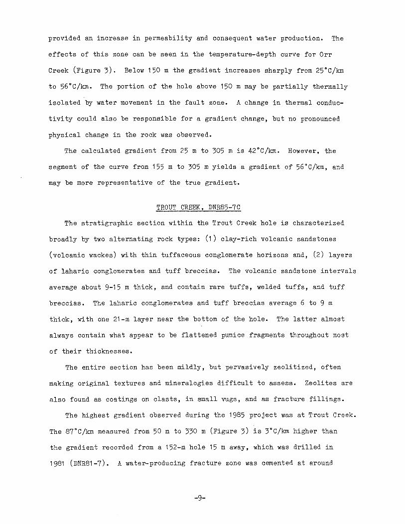
provided an increase in permeability and consequent water production. The
effects of this zone can be seen in the temperature-depth curve for Orr
Creek (Figure 3). Below 150 m the gradient increases sharply from 25°C/km
to 56°C/k:m. The portion of the hole above 150 m may be partially thermally
isolated by water movement in the fault zone. A change in thermal conduc
tivity could also be responsible for a gradient change, but no pronounced
physical change in the rock was observed.
The calculated gradient from 25 m to 305 mis 42°C/km. However, the
segment of the curve from 155 m to 305 m yields a gradient of 56°C/km, and
may be more representative of the true gradient.
TROUT CREEK, DNR85-7C
The stratigraphic section within the Trout Creek hole is characterized
broadly by two alternating rock types: (1) clay-rich volcanic sandstones
(volcanic wackes) with thin tuffaceous conglomerate horizons and, (2) layers
of laharic conglomerates and tuff breccias. The volcanic sandstone intervals
average about 9-15 m thick, and contain rare tuffs, welded tuffs, and tuff
breccias. The laharic conglomerates and tuff breccias average 6 to 9 m
thick, with one 21-m layer near the bottom of the hole. The latter almost
always contain what appear to be flattened pumice fragments throughout most
of their thicknesses.
The entire section has been mildly, but pervasively zeolitized, often
making original textures and mineralogies difficult to assess. Zeolites are
also found as coatings on clasts, in small vugs, and as fracture fillings.
The highest gradient observed during the 1985 project was at Trout Creek.
The 87°C/km measured from 50 m to 330 m (Figure 3) is 3°C/km higher than
the gradient recorded from a 152-m hole 15 m away, which was drilled in
1981 (DNR81-7). A water-producing fracture zone was cemented at around
-9-

0 5 10 15
TEMPERATURE°C 20 25 30 35 40
Ol------l...------1-r------:-------'-----~----~-----~---~
40
80
120
.... .... . ... . ... ...
.... ... ...
... Jr. ... ... ... ... ...
• • • • • • • • • Ill
Ill
•
Jr. ORR CREEK (DNR 85-1C)
• TROUT CREEK (DNR 85-7C)
Cl) 160 0:
... .... • • 87°C/km w
1-w ~
:r: la. w
200
... ... ... ... ... J;.
• 50m · 330m • 56°C/km
155m · 305m • • • •
C 240 ... •
280
320
360
... ... ...
J;.
BHT = 17.7°C 42°C/km
(25m-305m)
• • J;.
... • • • • • • • •
BHT = 36.3°C • 83°C/km
(25m-357m)
Figure 3. Temperature-depth curves for Orr Creek {DNR85-1 C) and Trout Creek {DNR85-7C) (see Figure 1 for locations}. Symbols represent temperature readings at 10-meter intervals. Bottom-hole temperature (BHT), overall gradient, and the interval over which the gradient is calculated are given at the endpoint of each curve. Bracketed segments of the curves represent straight line gradients that may be most representative of the true gradient for the hole.
10

195 m, but there appears to be no reflection of this zone on the temperature
depth curve. The overall straight-line gradient for Trout Creek is 83°C/km
measured from 25 m to 357 m. The last 20 to 30 m of the temperature-depth
curve shows a slight deflection toward a lower gradient. An increase in
fracture density is recorded from core near hole bottom, so increased water
circulation at this level is possible.
SPUD HILL, DNR85-2
This hole penetrates 18 m of buried talus originating from a Tertiary
rhyolite intrusive immediately to the south. From 18 m to the total depth
of 152 m, the section consists of Oligocene-Miocene pyroclastic and volcani
clastic rocks. Drill cuttings show the presence of small sandy layers which
produced some water (20 gpm), especially from 55 m to 85 m. The calculated
straight-line gradient from 25 m to 149 mis 72°C/km, which is the second
highest gradient recorded during the project (Figure 4). The small steep
ened section of the curve around 120 m may represent very limited downward
flow of water in this part of the hole.
MIDWAY, DNR85-3
The Midway hole was stopped 42 m short of the 152-m target depth due to
uncontrollable caving and water incursion at 110 m. Water production from
the hole before completion and sealing was as high as 100 gpm (estimated by
airlift). The hole penetrated 55 m of glacial drift and basaltic flow
breccia before entering the Oligocene-Miocene volcaniclastic/pyroclastic
rocks. The straight-line gradient (Figure 4) at Midway is 33°C/km, measured
from 15 m to 109 m. The rock at this location may be undergoing cooling by
Mount Adams glacial water flowing through valley-filling Quaternary basalt
flows and glacial drift.
-11-

TEMPERATURE°C 0 5 10 15 20
' I I I I I I I ' 0 u ........ u • er> A 0 • 0 <) A 0 • 0 <> A •O • SPUD HILL (DNR 85-2)
20 0 <> A • 0 0 MIDWAY (DNR 85-3) CX> A (lit o MT. ADAMS SE (DNR 85-4) <>O I:,. o•
<> 0 A Ce A BEAR SPRING (DNR 85-5) 40 ,_ <> 0 I:,. 0 • <> WEST CRATER (DNR 85-6) -
<> 0 A 0 • <> OA 0 • <> 06 0 • 60 '- 0 0A CJ • -0 c,.. 0 • 0 (». CJ •
en <> 0 0 • ex: 80 '- <> I.) • 0 w <> .I:{) CJ I- <> t:,t:) C> w ~ 0 AO CJ • - 100 <> t.O 0 • -:::c: 0 A 0 0 • I- <> A 0 BHT = 7.1 °C 0 • c.. w I:,. a • <> 33°C/km Cl 120 '- <> t. 0 • (15m-109m) <> A 0 •
<> A 0 • <> A 0 •
140 "- 0 A CJ • <> A BHT = 12.5°C • • BHT = 16.3°C 0 BHT = 3.0°C A BHT = 7.5°C 45°C/km 72°C/km
160 1- -4 °C/km 21 °C/km (30m-142m) (25m-149m) -
(35m-152m) (60m-150m)
180 - -
200
Figure 4. Temperature-depth curves for the five shallow test holes (see Figure 1 for locations). Symbols represent temperature readings at 5-meter intervals. Bottom-hole temperature (BHT), gradient, and the interval over which the gradient was calculated are given at the endpoint of each curve.
-12-

MOUNT ADAMS SE, DNR85-4
This hole was drilled entirely within basalt and associated interbeds of
the Columbia River Basalt Group, probably upper flows of the Grande Ronde
Formation. Flow breccia layers and sedimentary interbeds serve as aquifers
in the area, many of which are under artesian pressure. One artesian aquifer
was encountered at the bottom of the hole. Caving within gravel or flow
breccia at the 143-m level was severe enough to force completion of the hole
at this depth. The temperature-depth profile of this hole (Figure 4) shows
a pronounced irregularity that may be the result of the penetration of the
aquifer near hole bottom. Between the 70-m and 80-m levels in the hole the
temperature jumps from about 9°c to over 12°c, and then remains nearly iso
thermal below the 80-m level. A possible reason for this sudden increase is
that relatively warm (12°C) water was encountered in an aquifer near the
bottom of the hole, and is flowing upward under artesian pressure to about
the 70-m level. Around 70-80 m, the water is probably exiting the hole
through a thief zone. Ineffective sealing of the annulus could be responsible
for this condition. The portion of the hole between 30 m and 142 m yields
a calculated straight-line gradient of 45°C/km.
BEAR SPRING, DNR85-5
The first 20 m of this hole penetrates Quaternary basaltic flow breccia
and intercalated sediments, possibly originating from the nearby Flattop
Mountain eruptive center. The remaining 132 m of the hole was drilled into
Oligocene-Miocene volcaniclastic and pyroclastic rocks similar to those dis
cussed earlier. The gradient of 21°C/km (Figure 4) is much lower than ex
pected for this portion of the Cascade Mountains, based on the results of
-13-
nearby heat flow holes drilled in 1975 (Schuster and others, 1978). The
reason for the low gradient is unknown, but cold water circulation to con
siderable depth within the bedrock may be masking the true gradient.
WEST CRATER DNR85-6
The West Crater hole was also drilled into Oligocene-Miocene volcaniclastic
and pyroclastic rocks, after being cased through 15 m of andesitic flow breccia
and pyroclastic rocks. The material in the upper 15 m of the hole probably
originates from the West Crater volcano (Quaternary) less than 1/4-mile south
of the hole site. The gradient in the West Crater hole is isothermal. In
fact, the gradient fr9m 35 m to hole bottom is a negative 4°C/km, and the
bottom-hole temperature is only 3°c (Figure 4). The West Crater curve
illustrates what may be the result of drilling into rocks pervaded by
extremely cold (3°c) groundwater to considerable depth. The large
Quaternary cinder cones and scoriaceous volcanic edifices in the immediate
vicinity of the hole serve as tremendous cold water recharge areas.
Although the West Crater hole was drilled into relatively "tight" Tertiary
rocks, the circulation of the cold water into fracture systems below the
depth of the hole bottom may be imparting a low temperature to rocks beyond
and below the Quaternary pile.
HEAT FLOW
At the time of this writing, no thermal conductivity measurements have
been made for rock samples from the 1985 project. However, rock nearly
identical to the Oligocene-Miocene volcaniclastics encountered in the Spud
Hill, Midway, Bear Spring, and Trout Creek holes has been tested for thermal
conductivity in past projects. The range of values for this rock type is
1 .4 to 1 .8 W/m0 c. Using these figures as estimates for thermal conductivity
yields the following range of heat flow values:
-14-

Spud Hill
Midway
Bear Spring
Trout Creek
100 to 130 mW/m2
46 to 59 mW/m2
29 to 38 mW/m2
122 to 157 mW/m2
Basalt of the Grande Ronde Formation, such as encountered at Mount Adams SE,
is thought to have thermal conductivities averaging between 1.4 to 1.6 W/m°C
(Korosec, personal communication). Given the temperature gradient of 45°C/
km in the Mount Adams SE hole, the heat flow values could range between
63mW/m2 and 72mW/m2.
A wider range of thermal conductivities is estimated for diorite and
quartz diorite similar to that found in the Orr Creek hole (Korosec, per
sonal communication). Using the range of conductivities of 2.0 to 3.0
W/m°C, and the highest gradient obtained from the Orr Creek hole (56°C/km),
heat flow values are estimated to be between 112 mW/m2 and 168 mW/m2 for
this location.
The above estimates use gradients measured directly from the holes and
do not take into consideration terrain corrections which may be necessary.
-15-

REFERENCES
Berri, D. A.; Korosec, M.A., 1983, Geological and geothermal investigation of the lower Wind River valley, southwestern Washington, Cascade Range: Washington Division of Geology and Earth Resources Open-File Report 83-5, 2 plates, scale 1:24,000, 46 p.
Hammond, P. E.; Korosec, M.A., 1983, Geochemical analyses, age dates, and flow-volume estimates for Quaternary volcanic rocks, southern Cascade Mountains, Washington: Washington Division of Geology and Earth Resources Open-File Report 83-13, 36 p., 1 map.
Korosec, M.A.; Schuster, J.E.; and others, 1980, The 1979-1980 geothermal resource assessment program in Washington: Washington Division of Geology and Earth Resources Open-File Report 81-3, 270 p., 1 map, scale 1:24,000.
Korosec, M.A., 1983, The 1983 temperature gradient and heat flow drilling project for the State of Washington: Washington Division of Geology and Earth Resources Open-File Report 83-12, 13 p.
Schuster, J.E.; Blackwell, D. D.; Hammond, P. E.; Huntting, M. T., 1978, Heat flow studies in the Steamboat Mountain-Lemei Rock area, Skamania County, Washington: Washington Division of Geology and Earth Resources Information Circular 62, 56 p.
-16-

APPENDIX A
Lithologic Logs for 1985
Geothermal Gradient Test Holes

Depth (Meters) From To
0 2.4
31.3
31.3 41.0
41.0 67.0
67.0 68.0
68.0 77.0
77.0 80.5
80.5 143.0
Orr Creek (DNR85-1C)
Description
Unconsolidated colluviu.m and soil. Clasts consist of boulders of volcaniclastic rocks and quartz diorite (weathered quartz diorite bedrock).
Quartz diorite (porphyritic), light brown-green with plagioclase phenocryst up to 5 mm, biotite phenocrysts up to 7 mm, and hornblende (less abundant) up to 3 mm. Vertical fractures prominent throughout. Fracture filling consists of zeolites (stilbite), calcite and clay. Plagioclase replaced by calcite near fractures.
Fault or shear zone. Medium brown soft clay gouge with breccia clasts of quartz diorite. Rare pyrite on fracture walls with calcite and zeolites.
Quartz diorite (porphyritic), medium blue-green (propylitic alt.?). Phenocrysts of plagioclase up to 9 mm; biotite up to 9 mm; biotite altered to chlorite especially near fractures. Hornblende more abundant than above, but <5%. Intense fracturing 55.6 m to 57.0 m. Fractures healed with zeolites, calcite and clay.
Shear zone. Brecciated porphyritic quartz diorite with clay gouge and calcite/zeolite fracture fillings. Slickensides present.
Quartz diorite (porphyritic) - Highly fractured with some brecciation zones, light brown. Slickensides in some fractures. Calcite, zeolite and clay fracture filling.
Fault or shear zone. Light gray-brown clay gouge with porphyritic quartz diorite breccia clasts and slickensides. Zeolites and calcite in fractures within clay gouge and around clasts of quartz diorite.
Quartz diorite (porphyritic) blue-green, light brown near large fractures. Xenolithic material at 105 m, 111 m, and 136 m consisting of finer-grained diorite/quartz diorite. Xenoliths enriched in magnetite.
-18-

Depth From
143.0
173.2
227.0
230.0
246.0
247.7
(Meters) To
173.2
227.0
230.0
246.0
247.7
305.0 (TD)
Orr Creek (DNR85-1C) - Continued
Description
Fault or shear zone. Highly fractured and brecciated porphyritic quartz diorite, light brown. Clay gouge in larger fractures. Zeolite fracture filling throughout. Slickensides common throughout zone. Propylitic alteration especially prominent 161.6 m to 172.3 m. Plagioclase replacement by epidote. Some water reported in this interval.
Quartz diorite (porphyritic), blue-green. Fractured and brecciated at 195.0 m to 198.0 m. Highly fractured at 207.3 m with calcite, zeolite, and subordinate quartz fracture filling.
Quartz diorite (porphyritic) - Highly fractured and containing hydrothermal veining consisting mostly of quartz (crystals up to 2 mm) and clay with pyrolusite coating on fracture walls.
Quartz diorite (porphyritic), blue-green, except around prominent fractures where light brown. Ubiquitous euhedral magnetite up to 1 mm. Fractures contain calcite, zeolite and minor quartz and epidote. Mafic minerals more abundant than in previous intervals.
Fault zone or shear zone. Highly altered and brecciated porphyritic quartz diorite. Slickensides along slip planes. Epidote, calcite and zeolite fracture filling.
Quartz diorite (porphyritic), green to blue-green overall color. Hornblende phenocrysts up to 1 cm. Magnetite up to 5%. Other phenocrysts include plagioclase and heavily chloritized biotite. Minor sheared and fractured zones at 271 .Om, 273.0 m and 279.0 m. Fractures appear to contain increasing amounts of quartz downward.
-19-
Depth From
0
18.3
21.3
53.4
55.0
95.0
109. 7
(Meters) To
18 .3
21.3
53.4
55.0
95.0
109.7
152.0 (TD)
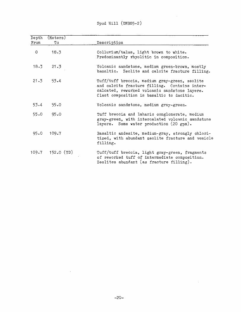
Spud Hill (DNR85-2)
Description
Colluvium/talus, light brown to white. Predominantly rhyolitic in composition.
Volcanic sandstone, medium green-brown, mostly basaltic. Zeolite and calcite fracture filling.
Tuff/tuff breccia, medium gray-green, zeolite and calcite fracture filling. Contains intercalcated, reworked volcanic sandstone layers. Clast composition is basaltic to dacitic.
Volcanic sandstone, medium gray-green.
Tuff breccia and laharic conglomerate, medium gray-green, with intercalated volcanic sandstone layers. Some water production (20 gpm).
Basaltic andesite, medium-gray, strongly chloritized, with abundant zeolite fracture and vesicle filling.
Tuff/tuff breccia, light gray-green, fragments of reworked tuff of intermediate composition. Zeolites abundant (as fracture filling).
-20-

Depth From
0
2.0
1 5 .2
27.4
55.0
(Meters) To
2.0
15.2
27.4
55 .o
110.0 (TD)
Midway (DNR85-3)
Description
Soil and weathered aphyric basalt, medium redbrown.
Basalt and basaltic flow breccia, dark redbrown. Hyaloclastic and palagonitic material in some layers. Scoriaceous in some layers. Abundant carbonaceous debris.
Gravel and sandy gravel, medium brown. Clasts are subrounded to subangular and mostly andesitic. Some quartzose sand layers (arkosic?).
Tuff or tuffite, light brown to green. Hornblende phenocrysts visible throughout.
Volcanic sandstone - conglomeratic, dark bluegreen. Contains clasts of andesite. Contains tuff breccia layers with plagioclase phenocrysts. Abundant water (100 gpm) encountered at bottom.
-21-

Depth (Meters) From To
0 2.0
2.0 12.2
12 .2 41.2
41.2 53.4
53.4 62.5
62.5 93.0
93.0 100.6
100.6 141 .8
141 .8 144.0 (TD)
Mount Adams SE (DNR85-4)
Description
Soil, red-brown sandy loam, contains weathered basalt colluvium near base.
Basalt, black, aphyric. Fractured at 10.7 m.
Basalt, black to dark brown, aphyric, light brown and weathered in joints/fractures especially at 21 .3 m. Vesicular at 29.0 m to 36.6 m. Interbeds of mostly basaltic sand at 18.3 m to 23.0 m, 24.0 m to 25.0 m and 36.6 m to 37.0 m, fine to mediumgrained.
Sand, medium to light gray-brown, fine-grained. Minor basalt flow or talus at 49.0 m to 50.0 m.
Basalt, medium to light brown, becoming black at 56.4 m to 62.5 m, aphyric, vesicular.
Sand, medium brown. Contains gravel at 70.0 m to 71.0 m, 73.0 m to 76.0 m and 79.3 m to 80.3 m. Minor clay, soft, at 71 .6 m to 72.6 m and 76.2 m to 79.0 m. Basalt flow(?), aphyric, vesicular at 80.8 m to 86.9 m.
Basalt, medium brown to black, aphyric. Scoriaceous with palagonite at 93.0 m to 96.0 m. Vesicular 99.0 m to 100.0 m.
Interbedded basalt and basaltic sand. Basalt flows (?) average 1-2 m thick are aphyric, black, vesicular and often contain palagonite and flow breccia material. Sand is dark gray, fine-grained, mostly basaltic.
Gravel, basaltic, angular to subangular clasts, with red-brown sand matrix. Water production estimated at 60 gpm this interval, caused hole caving and cessation of drilling.
-22-
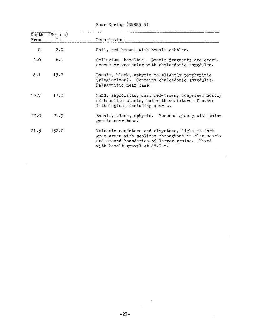
Depth From
0
2.0
6 .1
13. 7
17.0
21.3
(Meters) To
2.0
6 .1
13.7
17.0
21.3
152.0
Bear Spring (DNR85-5)
Description
Soil, red-brown, with basalt cobbles.
Colluvium, basaltic. Basalt fragments are scoriaceous or vesicular with chalcedonic amygdules.
Basalt, black, aphyric to slightly porphyritic (plagioclase). Contains chalcedonic amygdules. Palagonitic near base.
Sand, saprolitic, dark red-brown, comprised mostly of basaltic clasts, but with admixture of other lithologies, including quartz.
Basalt, black, aphyric. Becomes glassy with palagonite near base.
Volcanic sandstone and claystone, light to dark gray-green with zeolites throughout in clay matrix and around boundaries of larger grains. Mixed with basalt gravel at 46.0 m.
-23-

Depth (Meters) From To
0 2.0
2.0 3.0
3.0 5.0
5.0 15.2
15.2 26.0
26.0 65.5
65.5 72.0
72.0 96.0
96.0 103.7
103.7 106.7
106.7 112.8
112.8 152.0 (TD)
West Crater (DNR85-6)
Description
Soil, blue-gray clayey loam. Highly weathered palagonitic material (flow breccia?).
Tuff breccia and flow breccia, andesitic, medium green-brown with light brown pumice fragments.
Claystone, medium gray to blue-green.
Tuff/tuff breccia, medium gray-brown with andesite clasts.
Claystone, medium gray and blue-green. Appears as volcanic wacke in some intervals.
Tuff/tuffaceous claystone, medium brown with light-colored angular clasts up to 2 mm (zeolitized plagioclase, in part).
Tuff, red-brown. Plagioclase phenocrysts. Rock fragments up to 2-3 mm.
Volcanic sandstone, medium to light gray-green. Pumiceous in some layers. Zeolites common between grains and in small fractures.
Claystone, tuffaceous, medium gray-green, with zeolite fracture filling.
Volcanic sandstone, light gray-green, fine- to very fine-grained. Could be reworked airfall tuff.
Tuff, medium gray-green to brown. Plagioclase phenocrysts visible near base. May, in part, be reworked.
Volcanic sandstone and wacke, medium gray-green to dark brown. Tuffaceous throughout. Some restricted tuff or tufflava layers present (1 .5 m thick). Conglomeratic 125.0 to 128.0 m. Clasts mostly andesitic. Quartzose sand near base.
-24-

Depth (Meters) From To
0 1.5
1.5 5.0
5.0 12.0
1 2. 0 20.0
20.0 29.0
29.0 39.6
39.6 41 .3
41 .3 73 .2
73.2 97.7
97.7 108.0
108 .o 119 .o
119.0 122.8
Trout Creek (DNR85-7C)
Description
Soil, colluvium, medium red-brown, sandy with vesicular basalt cobbles.
Basalt, dark brown, fine-grained, somewhat vesicular. Olivine phenocrysts.
Gravel, with minor mixed sand and clay. Medium brown. Larger clasts are of diorite and basalt. Basalt more abundant.
Clay, light brown, soft.
Gravel; clayey-sandy, medium brown, subangular clasts. Clasts predominantly basalt.
Porphyritic andesite, dark gray-brown. Plagioclase phenocrysts up to 3 mm. Appears to have considerable glass content. Some water reported this interval. (Est. 3-5 gpm). (Core drilling began at 39.0 m).
Laharic conglomerate, blue-green to medium graygreen. Flattened pumice fragments throughout up to 2 cm in maximum dimension.
Conglomeratic volcanic wacke with subordinate layers of tuff, tuff breccias and claystone, medium to dark gray-green. Larger clasts are matrix-supported and mostly subangular. Pervasively zeolitized; zeolites occur as replacement of clasts and plagioclase crystals, and as interstitial fillings between clasts.
Volcanic wacke and volcanic sandstone, medium gray-green, with conglomeratic horizons especially at 83.0 m. Prominent fracturing with slickensides at 89.0 m. Fracture wall coating is serpentine.
Laharic conglomerate and tuff breccia, medium graygreen, with thin horizons of volcanic wacke. Fractures at 103 m with slickensides.
Volcanic wacke, medium gray-green, with conglomeratic and tuffaceous horizons in lower portion of interval.
Lapilli tuff, light gray-green, pumiceous throughout; possibly welded, some layers. Hornblende phenocrysts up to 2 mm.
-25-

Depth From
122.8
130.0
184.5
200.0
213.6
222.3
302.1
323.0
(Meters) To
130.0
184.5
196.5
200.0
213.6
222.3
302.1
323.0
345.4
Trout Creek (DNR85-7C) - Cont'd
Description
Volcanic wacke, dark gray-green. Thin conglomeratic intervals throughout.
Volcanic wacke and volcanic sandstone, medium graygreen, with interbedded conglomerates, some appearing to be laharic. Prominent shear zone at 137.8 m, with slickensides and clay gouge.
Volcanic wacke and volcanic sandstone, medium graygreen. Notably fractured throughout interval, with brecciation and slickensides at 195.0 m to 196.0 m. Serpentine fracture filling common. Water-producing zone reported at 195.0 m (indeterminate rate).
Volcanic conglomerate, dark gray-green. Clastsupported. Clast are predominantly andesitic and angular to subangular.
Volcanic sandstone, light to medium gray-green, with interbedded volcanic wacke. Conglomeratic 204.0 m to 206.0 m. Pervasively zeolitized, with drussy zeolite fracture/vug coatings in conglomeratic layer.
Laharic volcanic conglomerate, light gray-green. Pumiceous, tuffaceous throughout.
Volcanic sandstone, medium-dark gray-green, with interbedded horizons of volcanic wacke, tuff, and volcanic conglomerate. Prominent shear zone at 231 .4 m. Dense fracturing at 285.0 m. Welded tuff layers at 263.0 m to 263.5 m and 288.0 m to 289.0 m.
Laharic volcanic conglomerate, light gray-green. Pumiceous and tuffaceous throughout. Clasts up to 2 cm. Plagioclase phenocrysts visible (replaced by zeolite in some cases) in flattened pumice fragments. Very competent rock.
Volcanic sandstone and volcanic wacke, light graygreen to medium gray-brown. Tuffaceous throughout. Conglomeratic at 330.0 m to 332.0 m and 340.0 m to 341 .Om. Prominent fracturing at 341 .5 and 345.0 m.
-26-

Depth From
345.4
347.5
(Meters) To
347.5
357.0 (TD)
Trout Creek (DNR85-7C) - Cont'd
Description
Dacite intrusive(?), light gray, flow texture. 80% plagioclase. chill margins with overlying and Fractures conchoidally.
shows microlitic Baked contacts and underlying units.
Laharic volcanic conglomerate, medium gray-green. Pumiceous and tuffaceous throughout. May be partially tuff breccia.
-27-


APPENDIX B
Tables Showing Logging Dates, Locations, and Temperature-Depth Data
for 1985 Geothermal Gradient Test Holes

Example description for hole locations given in Appendix B
B A A
B A D
C e 2 Section 2 in Town5hip 4 North, Range 6 East
Hole
C D
Correct location description for the hole shown in the above example is; 4N, 6E, Sec. 2, BCD
-29-

DRILL HOLE= DNR 85-lC, ORR CREEK LOGGED 10-3-85
LOCATION= lON, lOE, SEC. 19, ACC
DEPTH TEMP. GRADIENT DEPTH TEMP. GRADIENT (METERS) (DEG. C) (DEG. C/krn) (METERS) (DEG. C) (DEG. C/krn}
0.95 10.02 195.00 11.23 28.00 5.00 7.43 -639.51 200.00 11.68 90.00
10.00 7.33 -20.00 205.00 12.10 84.00 15.00 5.70 -326.00 210.00 12.41 62.00 20.00 5.83 26.00 215.00 12.69 56.00 25.00 5.90 14.00 220.00 12.97 56.00 30.00 5.96 12.00 225.00 13.24 54.00 35.00 6.03 14.00 230.00 13.52 56.00 40.00 6.13 20.00 235.00 13.79 54.00 45.00 6.22 18.00 240.00 14.06 54.00 50.00 .6.32 20.00 245.00 14.33 54.00 55.00 6.45 26.00 250.00 14.62 58.00 60.00 6.62 34.00 255.00 14.91 58.00 65.00 6.75 26.00 260.00 15.19 56.00 70.00 6.91 32.00 265.00 15.48 58.00 75.00 7.09 36.00 270.00 15.56 16.00 80.00 7.40 62.00 275.00 16.10 108.00 85.00 7.56 32.00 280.00 16.33 46.00 90.00 7.57 2.00 285.00 16.59 52.00 95.00 7.69 24.00 290.00 16.81 44.00
100.00 7.83 28.00 295.00 17.10 58.00 105.00 7.97 28.00 300.00 17.43 66.00 110.00 8.11 28.00 305.00 17.73 60.00 115.00 8.24 26.00 120.00 8.36 24.00 125.00 8.46 20.00 130.00 8.54 16.00 135.00 8.61 14.00 140.00 8.66 10.00 145.00 8.74 16.00 150.00 9.02 56.00 155.00 9.40 76.00 160.00 9.82 84.00 165.00 10.14 64.00 170.00 10.42 56.00 175.00 10.70 56.00 180.00 10.94 48.00 185.00 11.06 24.00 190.00 11.09 6.00
-30-

DRILL HOLE= DNR 85-2, SPUD HILL LOGGED 10-24-85
LOCATION= lON, 9E, SEC. 21, CAB
DEPTH TEMP. GRADIENT (METERS) (DEG. C) (DEG. C/krn)
0.95 5.00
10.00 15.00 20.00 25.00 30.00 35.00 40.00 45.00 50.00 55.00 60.00 65.00 70.00 75.0-0 80.00 85.00 90.00 95.00
100.00 105.00 110.00 115.00 120.00 125.00 130.00 135.00 140.00 145.00 148.55
9.40 11.45
8.65 7.07 6.93 7.40 7.79 8.17 8.53 8.90 9.33 9.72
10 .12 10.61 11.40 11.62 11.88
. 12. 23 12.49 12.91 13.29 13.68 13.75 13.82 14.20 14.80 15.17 15.45 15.72 16.04 16.30
506.17 -560.00 -316.00 -28.00
94.00 78.00 76.00 72.00 74.00 86.00 78.00 80.00 98.00
158.00 44.00 52.00 70.00 52.00 84.00 76.00 78.00 14.00 14.00 76.00
120.00 74.00 56.00 54.00 64.00 73.24
DRILL HOLE= DNR 85-3, MIDWAY LOGGED 10-24-85
LOCATION= lON, lOE, SEC. 15, DBA
-31-
DEPTH TEMP. GRADIENT (METERS) (DEG. C) (DEG. C/krn)
0.95 5.00
10.00 15.00 20.00 25.00 30.00 35.00 40.00 45.00 50.00 55.00 60.00 65.00 70.00 75.00 80.00 85.00 90.00 95.00
100.00 105.00 109.75
6.37 4.90 3.93 4.00 4.04 4.24 4.44 4.63 4.77 4.97 5.13 5.27 5.42 5.57 5.74 5. 87 6.03 6.21 6.37 6.53 6.72 6.90 7.09
-362.96 -194.00
14.00 8.00
40.00 40.00 38.00 28.00 40.00 32.00 28.00 30.00 30.00 34.00 26.00 32.00 36.00 32.00 32.00 38.00 36.00. 40.00

DRILL HOLE= DNR 85-4, MT. ADAMS SE. DRILL HOLE= DNR 85-5, BEAR SPRING4
LOGGED 10-23-85 LOGGED 10-23-85 LOCATION= 7N, 12E, SEC. 9, CCC LOCATION= 6N, lOE, SEC. 7, ACD
DEPTH TEMP. GRADIENT DEPTH TEMP. GRADIENT (METERS} (DEG. C} (DEG. C/km} (METERS} (DEG. C} (DEG. C/KM)
0.95 8.54 0.95 7.19 5.00 7.93 -150.62 5.00 5.41 -439.51
10.00 7.63 -60.00 10.00 5.15 -52.00 15.00 7.45 -36.00 15.00 5.17 4.00
20.00 7.40 -10.00 20.00 5.16 -2.00
25.00 7.30 -20.00 25.00 5.18 4.00
30.00 7.55 50.00 30.00 5.21 6.00
35.00 7.76 42.00 35.00 5.25 8.00
40.00 7.96 40.00 40.00 5 .30 10.00
45.00 8.17 42.00 45.00 5.37 14.00
50.00 8.35 36.00 50.00 5.43 12.00
55.00 8.58 46.00 55.00 5.50 14.00
60.00 8.81 46.00 60.00 5.60 20.00
65.00 9.01 40.00 65.00 5.68 16.00
70.00 9.22 42.00 70.00 5.79 22.00 75.00 10.05 166.00 75.00 5.87 16.00 80.00 12.30 450.00 80.00 5.97 20.00
85.00 12.31 2.00 85.00 6.06 18.00 90.00 12.35 8.00 90.00 6.16 20.00
95.00 12.39 8.00 95.00 6.24 16.00
100.00 12.41 4.00 100.00 6.35 22.00
105.00 12.43 4.00 105.00 6.48 26.00
110.00 12.43 o.oo 110.00 6.57 18.00
115.00 12.46 6.00 115.00 6.67 20.00
120.00 12.46 o.oo 120.00 6. 76 18.00
125.00 12.46 o.oo 125.00 6.87 22.00
130.00 12.45 -2.00 130.00 6.98 22.00
135.00 12.51 12.00 135.00 7.09 22.00
140.00 12.53 4.00 140.00 7.21 24.00
141.60 12.53 0.00 145.00 7.33 24.00 150.00 7.45 24.00 152.20 7.51 27.27
-32-

DRILL HOLE= DNR 85-6, WEST CRATER LOGGED 10-23-85
LOCATION= SN, 6E, SEC. 29, DOC
DEPTH TEMP. GRADIENT (METERS) (DEG. C) (DEG. C/krn)
0.95 5.00
10.00 15.00 20.00 25.00 30.00 35.00 40.00 45.00 50.00 55.00 60.00 65.00 70.00 75.00 80.00 85.00 90.00 95.00
100~00 105.00 110.00 115.00 120.00 125.00 130.00 135.00 140.00 145.00 150.00 152.10
7.13 5.00 4.58 4.49 4.44 4.37 4.16 3.49 3.39 3.27 3.19 3.13 3.10 3.08 3.06 3.05 3.06 3.06 3.05 3.05 3.05 3.03 3.04 3.04 3.04 3.04 3.04 3.04 3.05 3.05 3.05 3.04
-33-
-525.93 -84.00 -18.00 -10.00 -14.00 -42.00
-134.00 -20.00 -24.00 -16.00 -12.00 -6.00 -4.00 -4.00 -2.00
2.00 0.00
-2.00 o.oo o.oo
-4.00 2.00 0.00 o.oo o.oo 0.00 o.oo 2.00 0.00 0.00
-4.76

DRILL HOLE= DNR 85-7C, TROUT CREEK LOGGED 10-22-85
LOCATION= 4N, 7E, SEC. 21, CDB
DEPTH TEMP. GRADIENT DEPTH TEMP. GRADIENT (METERS) (DEG. C) (DEG. C/krn) (METERS) (DEG. C) (DEG. C/krn)
0.95 9.88 235.00 26.74 94.00 5.00 8.85 -254.32 240.00 27.19 90.00
10.00 8.60 -50.00 245.00 27.61 84.00 15.00 8.34 -52.00 250.00 28.07 92.00 20.00 8.63 58.00 255.00 28.52 90.00 25.00 9.05 84.00 260.00 28.96 88.00 30.00 9.43 76.00 265.00 29.45 98.00 35.00 10.39 192.00 270.00 29.94 98.00 40.00 9.84 -110.00 275.00 30.38 88.00 45.00 10.17 66.00 280.00 30.86 96.00 50.00 10.58 82.00 285.00 31.16 60.00 55.00 10.96 76.00 290.00 31.68 104.00 60.00 11.34 76.00 295.00 32.14 92.00 65.00 11.87 106.00 300.00 32.56 84.00 70.00 12.22 70.00 305.00 33.05 98.00 75.00 12.60 76.00 310.00 33.34 58.00 80.00 13.06 92.00 315.00 33.76 84.00 85.00 13.22 32.00 320.00 34.08 64.00 90.00 13.83 122.00 325.00 34.45 74.00 95.00 14.26 86.00 330.00 34.86 82.00
100.00 14.68 84.00 335.00 35.22 72.00 105.00 15.10 84.00 340.00 35.56 68.00 110.00 15.52 84.00 345.00 35.86 60.00 115.00 15.96 88.00 350.00 36.10 48.00 120.00 16.39 86.00 356.70 36.29 28. 36 125.00 16.83 88.00 130.00 17.25 84.00 135.00 17.70 90.00 140.00 18.10 80.00 145.00 18.54 88.00 150.00 19.00 92.00 155.00 19.43 86.00 160.00 19.87 88.00 165.00 20.32 90.00 170.00 20.75 86.00 175.00 21.22 94.00 180.00 21.68 92.00 185.00 22.11 86.00 190.00 22.64 106.00 195.00 23.07 86.00 200.00 23.53 92.00 205.00 23.99 92.00 210.00 24.47 96.00 215.00 24.92 90.00 220.00 25.22 60.00 225.00 25.77 110.00 230.00 26.27 100.00
-34-