Embed Size (px)
Citation preview

Walks in the
Six scenic walks around Matlock, Matlock Bathand the surrounding area…
derbyshiredales.gov.uk
Arc LeisureMatlock
Oker
DarleyBridge
Bonsall
Cromford
MatlockBath
UpperHackney
MatlockRiber
StarkholmesHeights ofAbraham
Cable Car
MassonHill
Oker
DarleyBridge
Bonsall
Cromford
MatlockBath
Arc LeisureMatlock
UpperHackney
MatlockRiber
StarkholmesHeights ofAbraham
Cable Car
MassonHill
A6
A6
A6
A5012
B503
6A615
A632
A6
RiverDerwent
River Derwent
Metres0 500 1000
0 10.5
ScaleMetres
Mile
0 500 1000
0 10.5
Scale
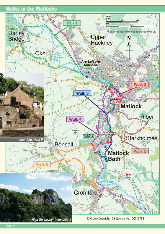
Walks in the Matlocks
Walk 1
Walk 2
Walk 3
Walk 4
Walk 5
Walk 6
High Tor viewed from Walk 4
Cromford, Walk 6
Page 2
All distances and timings indicated are approximate
© Crown Copyright. OS Licence No. 100019785

The Matlocks lie in the valley of the River Derwent, surrounded by limestone and gritstone hills, offeringsuperb walking along riverside and wooded hillside paths, with far reaching views. But scenery is not theonly attraction of the area. Visitors have come here since the 17th century, marvelling at the splendour of
High Tor and calling the area ‘Little Switzerland’. The building of the railway brought a boom in the tourists,particularly those who came to visit the spas and drink from mineral springs. They bathed in the waters whilststaying in one of the many ‘hydros’ built as hotels specialising in ‘water cures’.
Typical of the ‘spa architecture’ of the period is the Grand Pavilion at MatlockBath, built in the 1880s and now home to the Peak District Mining Museum andMatlock Bath Tourist Information Point. Another hydro here was the building nowoccupied by the Aquarium on North Parade. Half a million gallons of warm waterflow through the fishpool each day, once a bath for suffers of rheumatism. InMatlock a local textile manufacturer called John Smedley built the town’spremier hydro in 1862, treating over 2,000 patients a year. It now houses officesof Derbyshire County Council. The ruined outline of his home, Riber Castle,towers over the town.
A little further down the valley Sir Richard Arkwright made use of the river andbuilt the first water-powered cotton mill at Cromford in 1771. His two mills(Masson Mill and Cromford Mill) are now part of a Derwent Valley Mills WorldHeritage Site.Grand Pavilion, Matlock Bath
Page 3
Walks in the Matlocks
Leave your car at home!
There are railway stations at both Matlock andMatlock Bath on the line from Derby. Once in thearea it is easy to get around by bus. For informationand timetables contact:
Rail: www.nationalrail.co.uk Tel: 08457 48 49 50Bus: www.traveline.info Tel: 0871 200 22 33
High Tor, Walk 5
Walks 1 and 2 are circular, starting in Matlock. Walks 3 and4 are linear and you can return back to your starting pointby using the bus or train. Walk 3 starts at Matlock andfinishes at Matlock Bath. Walk 4 goes from Matlock Bath toMatlock so you can also link both of them together andcreate a longer, circular walk. Walks 5 and 6 are circular,starting in Matlock Bath.
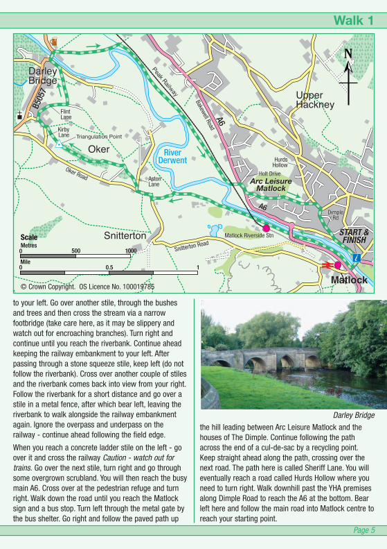
Walk 1 Matlock, Oker and Darley BridgeCircular walk from Matlock.Distance: 5 miles / 8 km. Page 4
Walk 2 Matlock to Pic TorShort circular walk from Matlock.Distance: 1.4 miles / 2.2 km. Page 6
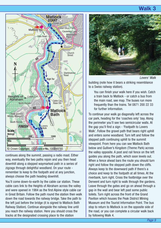
Walk 3 High Tor, Giddy Edge and a Lovers Walk!Matlock to Matlock Bath.Distance: 2.4 miles / 4 km. Page 8
Walk 4 By the Heights of AbrahamMatlock Bath to Matlock.Distance: 1.6 miles / 2.6 km. Page 10
Walk 5 Matlock Bath to High Tor and RiberCircular Walk from Matlock Bath.Distance: 3.3 miles / 5.3 km. Page 12
Walk 6 Matlock Bath, Bonsall Village & CromfordCircular Walk from Matlock Bath.Distance: 3.7 miles / 6 km. Page 14
The area has much of interest for the visitor. Why not take your time to experience it on one of these walks…There are six walks to choose from. Happy walking!

A pleasant circular walk from Matlock via Oker and Darley Bridge.
At the next waymark post continue straight ahead,passing though more hawthorn and make for the largetree on top of the hill. There are some great views alonghere. Walk along the permissive path to theTriangulation Point before descending steeply in thedirection of a church, passing an old bath to reach agate which leads on to a tarmac lane. Turn left and thenimmediately right and walk down the hill. Take the nextroad on the right (Flint Lane). Pass the Cross GreenCottages and, just after the road bends to the right youshould bear left, just past Bromley Croft. Continue alongthis lane which becomes an unsurfaced farm track. Turnleft at a waymarked stile with a fingerpost and followthe path down, keeping the field edge to your left. Goover the next stile and stone culvert and cross the field,bearing right, to go past the corner end of the borderinghedgerow and trees opposite. Ignore the stile nearthere, just continue diagonally across to reach the stilein the far corner of the field. Go over this stile and turnleft for Darley Bridge.
Turn right over the bridge using the pavement on theleft hand side. Just over the bridge, re-cross the road toFlatts Farm on your right. (You’ll see the pub ‘Square &Compass’ - just a bit further along the road to the left ifyou want to stop for some refreshments.) Go throughthe first stone stile and follow the waymarked pathstraight ahead - running alongside the wall with farmbuildings to your right.
Keep the stone wall to your left, crossing several stiles.At the fourth stile, head diagonally across the field andgo over a wooden stile. Ignore a path that runs off to theleft, continue ahead, keeping the field edge and stream
Walk 1 - Matlock, Oker and Darley Bridge
Page 4
The ascent of Oker Hill is fairly steep, otherwise thiswalk is fairly easy.
Duration - about 3 hours.Distance: 5 miles / 8 km.
From the Tourist Information Centre at Crown Square, goover the bridge and then turn right immediately, do notgo over the pedestrian crossing. Take the pavementleading down to the riverside footpath. Follow the pathalongside the river, passing under the road and railwaybridges and a factory until you reach pleasant openfields.
Continue ahead when you reach a junction with a farmtrack and a metal farm gate on your right. Go over astile where the path is rejoined with the riverbank. Youwill see a fork in the unsurfaced path here. You need togo left - diagonally across the field to reach a stile anda fingerpost. Go over the stile and turn right to followthe lane keeping on the right hand side of the road.Take care - watch out for traffic.
In about 150 yards you need to turn right into AstonLane. On you left you’ll see a stile by a fingerpost. Goover the stile and head up the field, bearing right. Thereis no obvious path across the field but when you reachthe trees (and a thicket of hawthorns) you should beable to pick out the path which leads up through thewood to some steps and a stile. Go over the stile andturn right. Bear left and immediately head up the bankthrough the gorse. At the top (by a waymark post) turnright and walk along the top of the ridge.
Triangulation point at Oker Ridge
Looking towards Darley Bridge
Arc LeisureMatlock
Oker
DarleyBridge
UpperHackney
Matlock
START &FINISH
Peak Railway
Triangulation Point
Matlock Riverside StnSnitterton
AstonLane
Oker Road
KirbyLane
FlintLane
Bakewell RoadHolt Drive
HurdsHollow
DimpleRd
Snitterton Road
Oker
DarleyBridge
UpperHackney
Matlock
START &FINISH
PeakRailway
Triangulation Point
Matlock Riverside StnSnitterton
AstonLane
Oker Road
KirbyLane
FlintLane
Bakewell RoadHolt Drive
HurdsHollow
DimpleRd
Snitterton Road
Arc LeisureMatlock
A6
A6
B505
7
RiverDerwent
Metres0 500 1000
0 10.5
ScaleMetres
Mile
0 500 1000
0 10.5
Scale
Page 5
to your left. Go over another stile, through the bushesand trees and then cross the stream via a narrowfootbridge (take care here, as it may be slippery andwatch out for encroaching branches). Turn right andcontinue until you reach the riverbank. Continue aheadkeeping the railway embankment to your left. Afterpassing through a stone squeeze stile, keep left (do notfollow the riverbank). Cross over another couple of stilesand the riverbank comes back into view from your right.Follow the riverbank for a short distance and go over astile in a metal fence, after which bear left, leaving theriverbank to walk alongside the railway embankmentagain. Ignore the overpass and underpass on therailway - continue ahead following the field edge.
When you reach a concrete ladder stile on the left - goover it and cross the railway Caution - watch out fortrains. Go over the next stile, turn right and go throughsome overgrown scrubland. You will then reach the busymain A6. Cross over at the pedestrian refuge and turnright. Walk down the road until you reach the Matlocksign and a bus stop. Turn left through the metal gate bythe bus shelter. Go right and follow the paved path up
the hill leading between Arc Leisure Matlock and thehouses of The Dimple. Continue following the pathacross the end of a cul-de-sac by a recycling point.Keep straight ahead along the path, crossing over thenext road. The path here is called Sheriff Lane. You willeventually reach a road called Hurds Hollow where youneed to turn right. Walk downhill past the YHA premisesalong Dimple Road to reach the A6 at the bottom. Bearleft here and follow the main road into Matlock centre toreach your starting point.
Darley Bridge
Walk 1
© Crown Copyright. OS Licence No. 100019785

An interesting short circular walk from Matlock via riverside and woodland paths.
MatlockSTART & FINISH
DaleRoad
OldeEnglishe
Road
Hall Leys Park
SteepTurnpike
Causeway Lane
Church StreetStoney WayWar
Memorial
PicTor
KnowlestonPlace
Crown Sq
Matlock Stn
Bakewell Rd
MatlockSTART & FINISH
DaleRoad
OldeEnglishe
Road
Hall Leys Park
SteepTurnpike
Causeway Lane
Church StreetStoney WayWar
Memorial
PicTor
KnowlestonPlace
Crown Sq
Matlock Stn
Bakewell Rd
A6
A615
A6
Metres0 500 1000
0 10.5
ScaleMetres
Mile
0 500 1000
0 10.5
Scale
Page 6
Walk 2 - Matlock to Pic Tor
This walk involves a fairly short strenuous uphillsection.
Duration - about 1 hour.Distance: 1.4 miles / 2.2 km.
You start this walk from the Matlock TouristInformation Centre, Crown Square.
Cross the main road outside the TouristInformation Centre. Turn right following DaleRoad over Matlock Bridge and round to the left.Dale Road (the main A6 through the town) ishome to antique shops, souvenir and gift shopsand several pubs, bars and cafes.
Turn first left into Olde Englishe Road. You thengo through a ‘Sensory Garden’ (a small flowergarden for the blind). Cross the footbridge overthe Derwent into Hall Leys Park. Notice the
signs on the bridge showing the level of the floods some yearsago. Turn right and follow the tree lined footpath. You’ll see aboating lake on your left and a miniature railway on your right.
Walk along the path through the park. As you leave the parkcontinue straight ahead onto a road called Knowleston Place.Follow the path that runs alongside the river. Look for a signpostthat directs you to the right, over a small bridge into Pic TorPark. Follow the path that runs between the cliffs and the river,which is known as The Promenade. Just before you reach arailway bridge, turn left by a waymark post and join the path upto Pic Tor.
The Memorial at Pic Tor
St Giles Church
© Crown Copyright. OS Licence No. 100019785

The path zigzags steadily uphill to the summit and thewar memorial.
There are great views; Riber Castle, Masson Hill, HighTor and Matlock Dale can all be admired from here.
From here take the concrete path which leads downthrough the graveyard to the Parish Church of St Giles.
When you reach the church, take the path to the right toexit via the church gate. Turn left and take the first leftdown a steep narrow lane called Stoney Way. At thebottom turn left to rejoin Knowleston Place, then followthe path straight back through Hall Leys Park to returnto Crown Square.
The children’s play area at Hall Leys Park
The view of Riber Castle from by the Memorial
A summer’s day at Hall Leys Park
Page 7
Walk 2

A linear walk with superb cliff-top views, from Matlock to Matlock Bath via High Tor.
This walk is considered to be unsuitable for youngchildren due to steep drops and cliff edges. The walkincludes fairly strenuous uphill sections.
Duration - about 1 hour 30 mins.Distance: 2.4 miles / 4 km.
Walk 3 - High Tor, Giddy Edge and a Lovers Walk!
Follow this path alongside the river until you go underthe railway bridge and then keep left to leave theriverbank. When you reach two bridges - one on yourright going over the river and one on your left goingunder railway, turn left and go under the bridge andfollow the path uphill. Just before you reach the firsthouse on the right, turn sharp right and go through thegateway into the High Tor grounds.
Follow the path that runs steadily uphill, taking time toadmire the views from the vantage points en route.
Take note of safety notices - keep to the path andsupervise children at all times.
From the first cliff-top viewpoint (there are some picnictables at this point and railings at the cliff edge) you cansee down into the Derwent Gorge, across to Masson Hilland, looking east, up to Riber Castle. Go along the path,which bears left and continues up hill. Eventually you’llsee the cliff face of High Tor ahead as you reach someopen meadow. You will pass some picnic tables, thereare more great views from here too. Continue up untilyou reach a grotto with a seat on your right. Turn righthere and follow the steps up towards the summit.Extreme care must be taken near these cliff edges.
High Tor, at 300 feet is one of the highest inland cliffs inEngland. If you are feeling very adventurous, aresurefooted and have a head for heights you have achoice here. You can continue via the risky route along‘Giddy Edge’ - definitely not for the feint hearted,although there are handrails for safety. For the ‘GiddyEdge’ route follow the path that forks to the right. Forthe main path (which is less scary) bear left; this
Page 8
The view from near Giddy Edge
The view down to Matlock Bath
There are frequent bus and rail services back alongthe A6 to the starting point at Matlock. Alternativelyyou can combine this walk with Walk 4 to create acircular route.
You start this walk from the Matlock Tourist InformationCentre, next to the bridge by Crown Square roundabout.Cross the road and walk straight ahead along the tree-lined path through Hall Leys Park. You’ll pass afootbridge over the River Derwent on your right. Notethe sign showing the level of the floods in past years.Continue through the park, passing the boating lake andminiature railway.
As you leave the park continue straight ahead onto aroad called Knowleston Place. Look for a signpost thatdirects you to the right, over a small bridge into Pic TorPark. Follow the path that runs between the cliffs andthe river, which is known as The Promenade.
MatlockBath
Matlock
Cable Car Base Stn
Heights ofAbraham
START
FINISH
High Tor
Peak DistrictMining Museum
Crown Sq
Hall Leys ParkCauseway Lane
KnowlestonPlaceDale Road
North Parade
South Parade
ChurchStreet
StarkholmesRoad
LoversWalk
Cable Car
Matlock Stn
MatlockBath
Matlock
Cable CarBase Stn
Heights ofAbraham
START
FINISH
High Tor
Peak DistrictMining Museum
Crown Sq
Hall Leys ParkCauseway Lane
KnowlestonPlaceDale Road
North Parade
South Parade
ChurchStreet
StarkholmesRoad
LoversWalk
Cable Car
Matlock Stn
A6
A6
Page 9
Metres0 500 1000
0 10.5
ScaleMetres
Mile
0 500 1000
0 10.5
Scale
continues along the summit, passing a radio mast. Eitherway, eventually the two paths rejoin and you then headdownhill along a stepped waymarked path in a series ofzigzags through delightful woodland. On your route -remember to keep to the footpath and at any junction,always choose the path heading downhill.
You’ll come down-to-earth by the cable car station. Thesecable cars link to the Heights of Abraham across the valleyand were opened in 1984 as the first Alpine style cable carin Great Britain. Follow the path round the station then walkdown the road towards the railway bridge. Take the path tothe left just before the bridge (it is signed to Matlock BathRailway Station). Continue alongside the railway line untilyou reach the railway station. Here you should cross thetracks at the designated crossing place to the station
building (note how it bears a striking resemblanceto a Swiss railway station).
You can finish your walk here if you wish. Catcha train back to Matlock - or catch a bus fromthe main road, see map. The buses run morefrequently than the trains. Tel 0871 200 22 33for further information.
To continue your walk go diagonally left across thecar park, heading for the ‘coaches only’ bay. Alongthe perimeter you’ll see two semicircular walls. Atthe gap you’ll find a sign - ‘Footpath to LoversWalk’. Follow the gravel path that bears right uphilland enters some woodland. Turn left and follow thestepped path continuing uphill to the summitviewpoint. From here you can see Matlock Bathbelow and Gulliver’s Kingdom (Theme Park) acrossthe valley opposite. A post and rail fence on the leftguides you along the path, which soon levels out.When a fence ahead bars the route you should turnright and follow the stepped path down the cliffs.Always keep to the downward path if there’s achoice and keep to the footpath at all times. At theriverbank, turn right. Cross the footbridge over theDerwent and turn right to walk through the gardens.Leave through the gates and go on ahead through agap in the wall and bear left past some publictoilets. Turn right across the front of the GrandPavilion which houses the Peak District MiningMuseum and the Tourist Information Point. The busstop to return to Matlock is on the opposite side ofthe road, or you can complete a circular walk backby following Walk 4.
Lovers’ Walk
Walk 3
© Crown Copyright. OS Licence No. 100019785
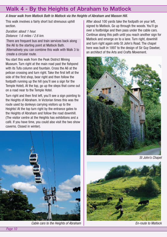
A linear walk from Matlock Bath to Matlock via the Heights of Abraham and Masson Hill.
Page 10
Walk 4 - By the Heights of Abraham to Matlock
This walk involves a fairly short but strenuous uphillsection.
Duration: about 1 hour.Distance: 1.6 miles / 2.6 km.
After about 100 yards take the footpath on your left,signed to Matlock. Go up through the woods. You’ll goover a footbridge and then pass under the cable cars.Continue along this path until you reach another sign forMatlock and emerge on to a lane. Turn right, downhilland turn right again onto St John’s Road. The chapelhere was built in 1897 to the design of Sir Guy Dawber,an architect of the Arts and Crafts Movement.
Cable cars to the Heights of Abraham
St John’s Chapel
En-route to Matlock
There are frequent bus and train services back alongthe A6 to the starting point at Matlock Bath.Alternatively you can combine this walk with Walk 3 tocreate a circular route.
You start this walk from the Peak District MiningMuseum. Turn right at the main road past the fishpondwith its Tufa column and fountain. Cross the A6 at thepelican crossing and turn right. Take the first left at theside of the first shop, bear right and then follow thefootpath running up the hill (you’ll see a sign for theTemple Hotel). At the top, go up the steps that come outon a road near to the Temple Hotel.
Turn right and then first left, you’ll see a sign pointing tothe Heights of Abraham. In Victorian times this was theroute used by donkeys carrying visitors up to theHeights! At the top turn right by the entrance gates tothe Heights of Abraham and follow the road downhill.(The visitor centre at the Heights has exhibitions and acafé. If you have time, you could also visit the two showcaverns. Closed in winter).

MatlockBath
Matlock
StarkholmesCable Car Base Stn
Cable CarHeights ofAbraham
FINISH
St John'sChapel
Peak DistrictMining Museum
North Parade
South Parade
UpperwoodRoad
DaleRoad
St John'sRoad
Snitterton Road
SaltersLane
START
Matlock Stn
MatlockBath
Matlock
StarkholmesCable CarBase Stn
Cable CarHeights ofAbraham
FINISH
St John'sChapel
Peak DistrictMining Museum
North Parade
South Parade
UpperwoodRoad
DaleRoad
St John'sRoad
Snitterton Road
SaltersLane
START
Matlock Stn
A6
A615
Page 11
Metres0 500 1000
0 10.5
ScaleMetres
Mile
0 500 1000
0 10.5
Scale
Just after the chapel, go left at afingerpost. Go through the stiles alongthe path. Note the good views of HighTor over the wall on the right. After awhile the path bears left across moreopen countryside. Then the pathswings right as some farm buildingscome into view ahead of you. Thepath then follows a wall, there is agood view of Riber Castle from heretoo.
You will then come to a gap stile inthe wall, by a fingerpost. Go throughthe stile and head diagonally lefttowards a gap in the hedge across thefield. All of Matlock is revealed beforeyou. Cross the next field bearingslightly right to reach a stile midwaybetween two metal gates. Continuedown, following the path across thenext field until you reach a stone stileby a house. Go through the stile anddown some steps continue ahead intothe lane.
Cross the railway bridge and turn rightinto Snitterton Road. Turn left at thebottom, then right over the roadcrossing and continue ahead over theriver bridge towards Crown Squareand Matlock Tourist InformationCentre.
Great views of Matlock The route joins Snitterton Road
Walk 4
© Crown Copyright. OS Licence No. 100019785
A lovely circular walk from Matlock Bath via High Tor, Riber and Starkholmes.
Bear right, up the stepped zigzag path. At the junctionwith a waymarked post, follow the uphill path to the left.
Keep to the distinct path. Take note of safety notices -keep to the path and supervise children at all times.
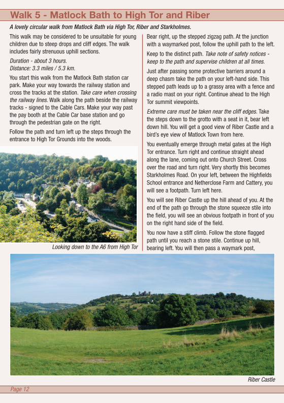
Just after passing some protective barriers around adeep chasm take the path on your left-hand side. Thisstepped path leads up to a grassy area with a fence anda radio mast on your right. Continue ahead to the HighTor summit viewpoints.
Extreme care must be taken near the cliff edges. Takethe steps down to the grotto with a seat in it, bear leftdown hill. You will get a good view of Riber Castle and abird’s eye view of Matlock Town from here.
You eventually emerge through metal gates at the HighTor entrance. Turn right and continue straight aheadalong the lane, coming out onto Church Street. Crossover the road and turn right. Very shortly this becomesStarkholmes Road. On your left, between the HighfieldsSchool entrance and Netherclose Farm and Cattery, youwill see a footpath. Turn left here.
You will see Riber Castle up the hill ahead of you. At theend of the path go through the stone squeeze stile intothe field, you will see an obvious footpath in front of youon the right hand side of the field.
You now have a stiff climb. Follow the stone flaggedpath until you reach a stone stile. Continue up hill,bearing left. You will then pass a waymark post,
Walk 5 - Matlock Bath to High Tor and Riber
This walk may be considered to be unsuitable for youngchildren due to steep drops and cliff edges. The walkincludes fairly strenuous uphill sections.
Duration - about 3 hours.Distance: 3.3 miles / 5.3 km.
You start this walk from the Matlock Bath station carpark. Make your way towards the railway station andcross the tracks at the station. Take care when crossingthe railway lines. Walk along the path beside the railwaytracks - signed to the Cable Cars. Make your way pastthe pay booth at the Cable Car base station and gothrough the pedestrian gate on the right.
Follow the path and turn left up the steps through theentrance to High Tor Grounds into the woods.
Page 12
Riber Castle
Looking down to the A6 from High Tor

of houses by the red telephone box continue ahead andthen turn right at the junction, by Riber Manor (thisdates back to before 1633). Keep on the same road asyou pass the next road junction and the entrance toRiber Hall.
Continue straight on as you passHearthstone Lane on your left.Descend the steep hill until youreach a road signed ‘unsuitablefor motors’ on your left. Go downthis road (White Tor Road) whichemerges on Starkholmes Road.Turn right and go along the roadas far as the White Lion pub.Look for the footpath sign onyour left just before you reachthe pub. There’s attractive oldhorse trough at this point. Godown this tarmac path and whenyou reach a fairly open piece ofground, bear left. Keep the fenceand the more open fields to yourleft whilst keeping to the edge ofthe wood. You rejoin a tarmacpath and go through a stile. Thispath takes you back to the CableCar base station. Go through astone stile with a gate next to it,under the railway bridge andthen turn left to return to MatlockBath station car park.
MatlockBath
Matlock
Riber
StarkholmesCable Car Base Stn
Heights ofAbraham
START &FINISH
Castle
School
StarkholmesRoadHigh Tor
ChurchStreet
HearthstoneLane
RiberRoad
White TorRoad
StarkholmesRoad
Cable Car
MatlockBath
Matlock
Riber
StarkholmesCable CarBase Stn
Heights ofAbraham
START &FINISH
Castle
School
StarkholmesRoadHigh Tor
ChurchStreet
HearthstoneLane
RiberRoad
White TorRoad
StarkholmesRoad
Cable Car
A6
A615
Page 13
Metres0 500 1000
0 10.5
ScaleMetres
Mile
0 500 1000
0 10.5
Scale
continue ahead to cross a wooden stile, then pass anisolated house. Continue through another stone stilewhile following the path which runs round the perimeterfencing of the Riber Castle grounds (Riber Castle isclosed). Bear left down the lane. On reaching the cluster
The White Lion at StarkholmesOn the path up to Riber
Walk 5
© Crown Copyright. OS Licence No. 100019785
A pleasant circular walk from Matlock Bath to the historic areas of Bonsall and Cromford
There are a couple of fairly strenuous uphill sections.
Duration: about 3 hours.Distance: 3.7 miles / 6 km.
You start this walk from outside the Peak District MiningMuseum at Matlock Bath. Cross the main road (A6) atthe crossing and turn right along South Parade. Take thefirst left (Waterloo Road) just after Hodgkinsons Hotel.Climb Waterloo Road until you reach a cobbled footpathon your left. Take this path and at the top, climb thesteps leading to the road. Cross the road and continueup the footpath (West Bank) opposite, eventuallyemerging by an entrance to the ‘Heights of Abraham’.Turn left along Upperwood Road. Opposite the end of ahouse called ‘The Pines’, look for a footpath on the righthand side of the road. Climb the steep stepped path.When the steps peter out, continue to follow the paththrough the wood. At a junction with another footpath,turn left. Keep the edge of the woods to your left andcontinue uphill. Eventually when you reach the edge ofthe woods you’ll see a fingerpost and a stone squeezestile. Go through the stile continuing straight aheadtowards a farm gate. This is by Ember Farm. You needto go straight ahead onto Ember Lane.
Follow the lane down hill until you reach a junction andBonsall Church. You may wish to take some time to
Page 14
Walk 6 - Matlock Bath, Bonsall Village and Cromford
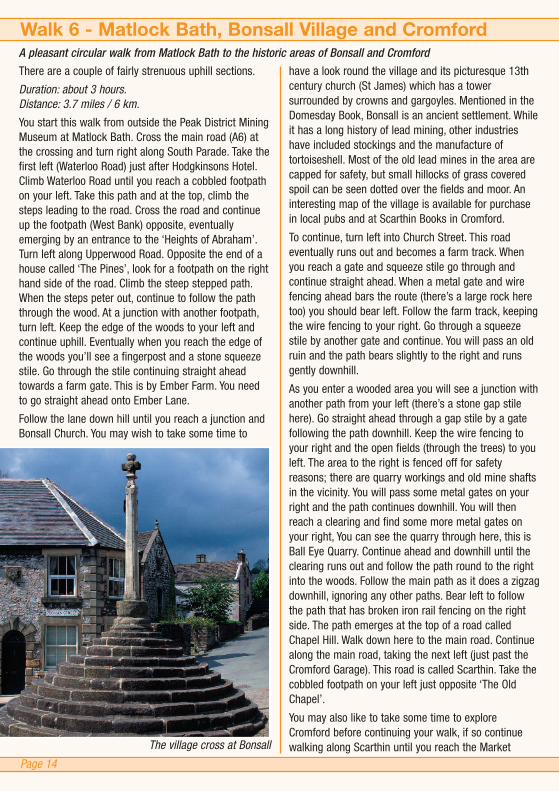
have a look round the village and its picturesque 13thcentury church (St James) which has a towersurrounded by crowns and gargoyles. Mentioned in theDomesday Book, Bonsall is an ancient settlement. Whileit has a long history of lead mining, other industrieshave included stockings and the manufacture oftortoiseshell. Most of the old lead mines in the area arecapped for safety, but small hillocks of grass coveredspoil can be seen dotted over the fields and moor. Aninteresting map of the village is available for purchasein local pubs and at Scarthin Books in Cromford.
To continue, turn left into Church Street. This roadeventually runs out and becomes a farm track. Whenyou reach a gate and squeeze stile go through andcontinue straight ahead. When a metal gate and wirefencing ahead bars the route (there’s a large rock heretoo) you should bear left. Follow the farm track, keepingthe wire fencing to your right. Go through a squeezestile by another gate and continue. You will pass an oldruin and the path bears slightly to the right and runsgently downhill.
As you enter a wooded area you will see a junction withanother path from your left (there’s a stone gap stilehere). Go straight ahead through a gap stile by a gatefollowing the path downhill. Keep the wire fencing toyour right and the open fields (through the trees) to youleft. The area to the right is fenced off for safetyreasons; there are quarry workings and old mine shaftsin the vicinity. You will pass some metal gates on yourright and the path continues downhill. You will thenreach a clearing and find some more metal gates onyour right, You can see the quarry through here, this isBall Eye Quarry. Continue ahead and downhill until theclearing runs out and follow the path round to the rightinto the woods. Follow the main path as it does a zigzagdownhill, ignoring any other paths. Bear left to followthe path that has broken iron rail fencing on the rightside. The path emerges at the top of a road calledChapel Hill. Walk down here to the main road. Continuealong the main road, taking the next left (just past theCromford Garage). This road is called Scarthin. Take thecobbled footpath on your left just opposite ‘The OldChapel’.
You may also like to take some time to exploreCromford before continuing your walk, if so continuewalking along Scarthin until you reach the MarketThe village cross at Bonsall

START& FINISH
CromfordStation
Bonsall
Cromford
MatlockBath
Peak DistrictMining MuseumSouth
Parade
UpperwoodRoad
Gulliver'sKingdom
DerbyRoad
Arkwright'sMillWater La
Via Gellia Road
Upperwood
Ember Lane
ChurchStreet
HighStreet
YoemanStreet
The Dale
Clatterway
BallEye
HarpEdge
Chapel Hill
Scarthin Mill Road
Bonsall
Cromford
MatlockBath
START& FINISH
Peak DistrictMining MuseumSouth
Parade
UpperwoodRoad
Gulliver'sKingdom
DerbyRoad
Arkwright'sMillWater La
Via Gellia Road
Upperwood
Ember Lane
ChurchStreet
HighStreet
YoemanStreet
The Dale
Clatterway
BallEye
HarpEdge
Chapel Hill
Scarthin Mill Road
CromfordStationA6A5012
River DerwentCromford
Wharf
Page 15
Metres0 500 1000
0 10.5
ScaleMetres
Mile
0 500 1000
0 10.5
Scale
Square. The village is part of the Derwent Valley MillsWorld Heritage Site where Richard Arkwright set up hiscotton-spinning mills powered by the River Derwent.
If you wish you can return back to Matlock Bath bybus. Services leave Cromford at frequent intervals.Telephone Traveline on 0871 200 22 33 forinformation.
The path runs up behind some houses. You’ll pass afingerpost pointing the way ahead (to Bonsall andMatlock Bath) continue uphill. After another few hundredyards you’ll reach a junction with a waymark postpointing sharp right (at an angle of about 45 degreesbackwards). Turn right here and continue over ‘HarpEdge’.
By the large house take the branch of the path whichgoes to the left, slightly uphill and behind a netballpitch. (Ignore the path going off to the right, past thehouse.) Follow the path, bear left at the waymark post.
At the next waymark post, a few yards further on (by acave entrance just to your left) you need to go straight-ahead. Continue to walk gently uphill through thewoods, the path gradually levels out. At the edge of thewood you’ll also reach a junction and see some housesin front of you. Follow the path straight ahead (just tothe left of the houses).
This path soon becomes a tarmac road as you passthrough the tiny hamlet of Upperwood. As you continueyou may notice how the tranquillity is broken by thesqueals of kids enjoying the various rides at ‘Gulliver’sKingdom’ theme park just up ahead of you. After goingpast a sign saying ‘Road Liable to Subsidence’ youshould see a stepped footpath going down hill to yourright. This is near to the ‘Heights of Jacob’. Take thispath that runs, in a series of zigzags, back down intoMatlock Bath. You emerge just by the entrance to the‘Gulliver’s Kingdom’. Walk round in front of the themepark and follow the road downhill. You’ll notice a metalfingerpost sign on your left indicating the route to take(left) back to the Peak District Mining Museum.
Mill Pond at Cromford
Walk 6
© Crown Copyright. OS Licence No. 100019785

Walks in the
Designed and produced by Simon Holt Marketing Services (www.simonholtmarketing.com)
This information is available free of charge in electronic,audio, Braille and large print versions, and in otherlanguages on request. For assistance in understanding orreading this document please call 01629 761 103.
derbyshiredales.gov.ukMarch 2011
If you are planning or short break or longer holiday in the Derbyshire Dalespick up a copy of the Peak District Visitor Guide from the Tourist InformationCentre or see www.visitpeakdistrict.com for places to visit, accommodationand events.
The five parks along the River Derwent are owned and managed by DerbyshireDales District Council and have been carefully restored to provide the continuousscenic riverside and cliff path walk from Matlock to Matlock Bath. Sections ofthis path are included in walks 3 and 5. More information on the parks, theirhistory and natural environment can be found in a free ‘Matlock Parks’ brochureavailable from the Tourist Information Centres above.
Visit a Tourist Information Centre for a wide range of local information, accommodation bookings and souvenirs.
Matlock Tourist Information CentreCrown SquareMatlockDerbyshire DE4 3AT
Tel: 01629 583 388
This guide is published by Derbyshire Dales District Council, Town Hall, Matlock, Derbyshire DE4 3NNTel: 01629 761 103. Email: [email protected] website: derbyshiredales.gov.uk
Matlock Bath Tourist Information PointPeak District Mining MuseumThe Pavilion, South ParadeMatlock Bath, Derbyshire DE4 3NR
Tel: 01629 583 834