Embed Size (px)
Citation preview

Walk Bike Dutchess
Chapter 2: Federal, State and Local Guidance Effective March 27, 2014
Chapter 2: Federal, State, and Local Guidance
Interest in pedestrian and bicycle planning has increased substantially since the 1996 Bicycle & Pedestrian Plan. This chapter reviews guidance and previous plans at the federal, State, County, and local level, as well as local comprehensive plans and codes. A. Federal In 2010, US Secretary of Transportation Ray LaHood signed a new USDOT Policy Statement on Bicycle and Pedestrian Accommodation which states that: “The DOT policy is to incorporate safe and convenient walking and bicycling facilities into transportation projects. Every transportation agency, including DOT, has the responsibility to improve conditions and opportunities for walking and bicycling and to integrate walking and bicycling into their transportation systems. Because of the numerous individual and community benefits that walking and bicycling provide — including health, safety, environmental, transportation, and quality of life — transportation agencies are encouraged to go beyond minimum standards to provide safe and convenient facilities for these modes.” The policy statement recommends that other agencies and organizations adopt similar policy statements, and:
• Consider walking and bicycling as equals with other transportation modes
• Ensure that there are transportation choices for people of all ages and abilities, especially children
• Go beyond minimum design standards
• Integrate bicycle and pedestrian accommodation on new, rehabilitated, and limited-access bridges
• Collect data on walking and biking trips • Set mode share targets for walking and bicycling and tracking
them over time • Remove snow from sidewalks and shared-use paths • Improve non-motorized facilities during maintenance projects The 2012 federal transportation bill, Moving Ahead for Progress in the 21st Century (MAP-21), continues the eight planning factors of the previous bill, SAFETEA-LU. Section 5303 of the bill states that the metropolitan planning process shall provide for consideration of projects and strategies that will support economic vitality, increase safety, increase security, increase accessibility and mobility, protect and enhance the environment and improve quality of life, enhance connectivity across and between modes, promote efficient system management, and emphasize preservation of the existing system. Walking and bicycling infrastructure directly supports these goals. The Americans with Disabilities Act of 1990 (ADA) aims to prevent discrimination against individuals with disabilities, including by making public rights-of-way accessible to all people. The U.S. Access Board developed detailed Public Right of Way Accessibility Guidelines (PROWAG) such as minimum sidewalk widths, maximum grades and slopes, and standards for curb ramps and crossings beginning in 1992, with revisions in 2005 and 2011. These guidelines continue to evolve based on research and best practices.
10

Walk Bike Dutchess
Chapter 2: Federal, State and Local Guidance Effective March 27, 2014
Complete streets serve all types of transportation (source: dot.ny.gov).
Curb ramps are critical to making sidewalks accessible.
B. State New York State’s Complete Streets Act (2011) states that “For all State, county, and local transportation facilities that receive both federal and state funding and are subject to Department of Transportation oversight, the department or agency with jurisdiction over such facilities shall consider the safe travel on the road network by all users of all ages, including motorists, pedestrians, bicyclists, and public transportation users through the use of complete street design features in the planning, design, construction, reconstruction, restriping and rehabilitation.” The law exempts resurfacing, maintenance, and pavement recycling projects as well as roads where walking and bicycling is prohibited by law. It also provides exemptions for situations when the cost
would be disproportionate to need (based on land use context, traffic volumes, population density, or other factors) or where there is demonstrated lack of need based on the above factors or demonstrated lack of community support. New York State’s Smart Growth Public Infrastructure Policy Act (2010) requires that state infrastructure spending meet ten specific smart growth criteria. These include: using, maintaining or improving existing infrastructure; locating projects in municipal centers or areas designated for infill development; protecting open space; fostering mixed land use and compact development; improving transportation choices; coordinating between State and local agencies; participating in community-based planning; ensuring predictability in codes; and promoting sustainability. The Act applies to projects approved, undertaken, supported or financed by State agencies or authorities, including through grants, awards, loans and assistance programs.
11

Walk Bike Dutchess
Chapter 2: Federal, State and Local Guidance Effective March 27, 2014
NYSDOT established a new Pedestrian and Bicycle Policy in 2010 which updated its 1996 policy. The policy states that NYSDOT will promote pedestrian and bicycle travel for all persons on the State transportation system. NYSDOT’s guidance states that the policy will be addressed in all planning, programming, scoping, design, construction, maintenance, operations, permits, and education and outreach programs. The objectives listed include promoting development of walking and bicycling networks; increasing the number of pedestrian and bicycle trips; reducing pedestrian and bicycle fatalities and serious injuries; and integrating walking and bicycling as viable modes for connectivity, smart growth, and transit oriented development. In 2010, NYSDOT drafted an ADA Transition Plan based on an ADA inventory of sidewalks, crosswalks, and curb ramps on State roads. The plan identifies intersections and sidewalk segments on State roads that are not fully ADA accessible. In Dutchess County, NYSDOT identified a total of 78 locations-- 39 intersections and 39 sidewalk segments-- that are not ADA accessible. These are listed in Appendix C to Moving Dutchess. According to the plan, 90 percent of the 43 miles of NYSDOT sidewalks in the county comply with ADA. The next phase of NYSDOT’s plan will include a prioritized list of improvements. NYSDOT expects to comply with ADA statewide by March 2027. ADA improvements in Dutchess County are currently planned to be completed by 2018. The New York Statewide Trails Plan (2010) establishes a vision of statewide trails networks including shared-use trails (such as rail trails), hiking trails, mountain bike trails, bicycle routes, and water trails to provide recreational opportunities; connect parks, forests, open spaces, historic and cultural sites, public facilities,
communities, and neighborhoods; attract economic opportunities; provide for alternative means of transportation; support tourism; promote residents’ health and well-being; and enhance quality of life. Within Dutchess County, the network includes the Hudson River, the Dutchess Rail Trail, Harlem Valley Rail Trail (and extensions north and south), Walkway Over the Hudson, Appalachian Trail, the proposed Greenway Trail along the Hudson River, and a proposed east-west rail trail (using Metro-North’s Beacon Line) into Putnam County. The plan describes trail types; outlines trail needs, trends, and benefits; and includes design standards for trail development. NYSDOT’s Strategic Highway Safety Plan (SHSP) is intended to promote practices that will reduce fatal and injury crashes. The 2010 SHSP includes objectives, performance measures, and strategies for seven emphasis areas, based on crash data: driver behavior, pedestrians, large trucks, motorcycles, highways, emergency medical services, and traffic safety information systems. To reduce pedestrian and bicycle fatalities, the SHSP calls for several strategies:
• Promote public awareness of pedestrian and bicycle safety issues and provide education and training for pedestrians, bicyclists and motorists
• Develop and implement engineering solutions to pedestrian and bicycle safety problems
12

Walk Bike Dutchess
Chapter 2: Federal, State and Local Guidance Effective March 27, 2014
The Regional Sustainability Plan prioritizes non-motorized transportation (source: hudsonvalleyregionalcouncil.org).
• Increase enforcement in documented high pedestrian crash locations, using tools such as electronic crash reporting to identify real-time hot spots
• Reconvene the New York State Bicycle and Pedestrian Safety Advisory Council
The SHSP specifically encourages MPOs (such as the PDCTC) and communities to implement pedestrian and bicycle safety programs and for schools to participate in Walk to School programs, Walking School Bus, Rolling School Bus, bicycle rodeos, and Safe Routes to School programs. Bicycle maps, safety brochures, and media campaigns are also encouraged. In terms of engineering, the SHSP encourages Safe Routes to School projects; sidewalk, crosswalk, and shoulder improvements; bicycle lanes, shoulders and multi-use trails; and pedestrian countdown timers, particularly at high-crash locations. It also encourages MPOs and local communities to develop bicycle plans. It highlights New York City’s Safe Routes to Transit and Safe Streets for Seniors programs, and the Capital District Transportation Committee’s (CDTC) ‘Capital Coexist’ bicycle education campaign. The Governor’s Traffic Safety Committee’s (GTSC) Highway Safety Strategic Plan (HSSP) is similar to the SHSP, but focuses more on behavioral approaches to safety. The 2013 HSSP includes a focus area on Pedestrian, Bicycle, and Wheel-Sport Safety. To reduce pedestrian and bicycle injuries and fatalities, the HSSP emphasizes public awareness, promoting a “Share the Road” message; safety education, particularly to youth; expanding bicycle rodeos and helmet distribution and fitting programs; and developing community-based coalitions to focus on pedestrian and bicycle safety.
C. Region/Mid-Hudson Valley The Mid-Hudson Region Economic Development Council’s Strategic Plan, adopted in November 2011, supports increasing walking and bicycling as part of a strategy to develop a green economy. The Plan recommends rewarding projects that address sustainable practices, including those that “promote reduction of transportation demand; shifting from single-occupant vehicles to reliance on transit, ride sharing/car pooling, and alternative modes of transportation such as biking and walking; using hybrid vehicles or non-fossil fuels in vehicles; and reducing fuel consumption” (page 46, Goal X, Strategy C). The Mid-Hudson Regional Sustainability Plan (2013) was developed by the Mid-Hudson Planning Consortium, a group of Hudson Valley counties, local governments, and other organizations, to promote economic development, environmental sustainability, and quality of life in the context of climate change. The Plan emphasizes the role of transportation in creating more sustainable communities: one of the Plan’s objectives is to create more ‘complete communities’ where residents can access jobs, services, schools, recreation, and
13

Walk Bike Dutchess
Chapter 2: Federal, State and Local Guidance Effective March 27, 2014
open space without having to drive (Objective TL2, page 4-21). This involves investing in sidewalks, crosswalks, bike lanes, and other non-motorized infrastructure to create Complete Streets. One of the Plan’s high-priority initiatives for implementation is to improve streets, sidewalks and trails to promote non-motorized transportation (page 4-33). The Hudson Valley Regional Council’s Comprehensive Economic Development Strategy (CEDS) analyzes the region’s strengths, weaknesses, opportunities, and threats and establishes goals and strategies related to economic development. The CEDS supports the vision of the Mid-Hudson Regional Sustainability Plan, including clustering development in existing centers to reduce automobile dependency, improve the environment, and foster economic development. D. Dutchess County The PDCTC’s 1996 Bicycle and Pedestrian Plan was the first bicycle and pedestrian plan for Dutchess County. It includes a description of existing conditions, results of a bicyclist survey, a discussion of major issues, and a series of recommendations, including a detailed inventory of characteristics and needs along existing and potential bicycle routes on State and County roads and local streets. Major issues identified in the Plan include the following, organized by the ‘Four E’s’ of Encouragement, Education, Enforcement, and Engineering:
• Encouragement: pedestrian and bicycle access via walking and bicycling facilities and transit accommodation; safety via
adequate facilities, lighting, patrols, signage, and bicycle storage; bicycle parking at major destinations and high-use areas; workplace incentives and facilities (showers, lockers) and information about potential routes; and signs for bicycle routes and crosswalks.
• Education: education in schools and for drivers about the rules of the road and bicycle and pedestrian safety.
• Enforcement: police enforcement of existing vehicle and traffic laws affecting walking and bicycling, and local police bicycle patrols.
• Engineering: facilities including road shoulders; wide curb lanes; bicycle lanes; bicycle paths and multi-use paths; sidewalks; traffic calming features; pedestrian signals and right turn on red restrictions; and bus shelters, lighting, landscaping, and seating. This section also discusses drainage grates, railroad crossings, sidewalk surfaces, and maintenance; pedestrian signals and signal detection of bicycles; signage and pavement markings; and bicycle parking.
The 1996 Plan’s recommendations include the following:
• Bicycle Network: the Plan includes maps and lists of recommended bicycle routes connecting residential areas to activity centers and employment destinations. Recommendations for these routes include a minimum shoulder width of four feet in rural and suburban areas, a 14 foot curb lane in urban areas, and bicycle lanes and/or separate paths on some State roads. The proposed bicycle networks for the County, City of Poughkeepsie, and City of
14

Walk Bike Dutchess
Chapter 2: Federal, State and Local Guidance Effective March 27, 2014
Beacon are shown in Maps 2 and 3. Cities, Towns, and Villages are recommended to develop their own routes for local trips.
• Pedestrian Zones: the Plan includes maps of Pedestrian Zones in cities, villages, hamlets, and activity centers. Recommendations for these zones include a complete sidewalk network connecting community uses, crosswalks at all major intersections, curb ramps, pedestrian signals, buffer zones, traffic calming, and lighting and other amenities.
• Land Use Strategies: the Plan recommends compact, mixed-use development within a ten minute walk of key community destinations to support walking and bicycling.
• Bicycle and Pedestrian Strategies: the Plan includes strategies related to education and safety, specific pedestrian and bicycle strategies, and project recommendations for routes identified in the bicycle network, bridges, paths, and local streets.
The Plan states that the recommendations will be considered as part of the PDCTC’s review of proposed transportation projects, and that all projects included on the Transportation Improvement Program (TIP) should be evaluated for inclusion of walking and bicycling facilities. In particular, the roads identified on the Bicycle Network should be considered priorities and proposed projects on those roadways should include walking and bicycling facilities as recommended in the Plan. Several of the 1996 Plan’s recommendations have been implemented: the Planning Department now maintains a GIS-based sidewalk inventory; sidewalks have been built and upgraded in many designated centers; and the PDCTC has conducted a series of sidewalk inventory projects in collaboration with municipalities.
The County Division of Public Transit has installed bike racks on all its buses and began a program to provide bicycle parking racks to municipalities. Access to the Mid-Hudson Bridge walkway was improved with the Gerald Drive ramp. Finally, the Dutchess Rail Trail and Walkway Over the Hudson have been completed and connected. Greenway Connections, developed by the Dutchess County Department of Planning and Development, describes the Greenway Compact program, a State-sponsored, voluntary partnership between the Hudson River Valley Greenway Communities Council and local governments to protect natural and cultural resources, foster economic development, improve public access and trails systems, support regional planning, and promote heritage and environmental education. Greenway Connections envisions an integrated system of ‘greenways’: scenic roads and streets, bicycle and transit routes, open space corridors, waterways, and sidewalks linked to trails throughout Dutchess County and the region. Communities that join the Greenway Compact are eligible for State grants, planning assistance, and other benefits.
15

Tivoli
NORTHEAST
MILAN
PINEPLAINS
RHINEBECK
Millerton
STANFORD
Rhinebeck
CLINTON
AMENIA
HYDEPARK
WASHINGTONPLEASANT
VALLEY
Millbrook
DOVERUNIONVALE
POUGHKEEPSIE
LAGRANGE
Poughkeepsie
BEEKMANWAPPINGER
EASTFISHKILL
PAWLINGWappingers
Falls
Pawling
FISHKILL
Fishkill
Beacon
RED HOOK
Red Hook
CD9G
CD115
CD308
CD9D
CD82
CD82
CD52
CD22
CD52B
CD82
CD22
CD9G
CD55
CD216
CD199 CD199
CD82
CD55
CD82
CD199
CD376
CD52
CD9D
CD343
CD199
CD22
CD22
CD199
CD199
CD22
CD376
CD199
CD113
CD343
CD55
CD343
CD52
CD376
CD9G
CD55
CD22
CD82
CD82
CD22
CD115
CD22
CD308
CD55
CD52
CD22
CD9G
CD199
CD55
CD292
456719
456721
456712
45674
456781
456742
456767
4567101
456724
456755
4567114
456720
456789
456764
456731
456736
456721
45671
456753
456730
456775
45672
456785
456729
456741
456771
456717
4567104
45679
456783
45675456719
45677456710
456737
456749
45679
456727
456777
456735
456718
456740A
456746
4567110456733
456794
456721
456792
456760
456784
456762
456772
456747
456734
456786
456714
456713
4567111
456774
456757
456788
456739
456778
456726
456741
456744
456783A
456740
456766
456765
456714
456738
456716
456761
456799
456783
456787
456793456791
4567103 456759
456754
456790
456734567105
456756
456769
456728
456743
456750
456722
456732
456779 456763
456782
4567100
456752
456796
456780
456770
456798
45676
456768
456723456773
456751
45678
456715
45679
456758
456795
£¤44
£¤44
£¤9
£¤44
£¤44
£¤44
£¤9
£¤9
£¤9
£¤9
£¤9
CETSP
CETSP
CETSP
CETSP
§̈¦84
1996 Bicycle and Pedestrian PlanBicycle Network
See detailed map for City of Poughkeepsie
See detailed map for City of Beacon
This map is intended for planning purposes only.The PDCTC shall not be held liable for any misuseor misrepresentation of this information.Map contents and data are subject to change.
Map created May 20141 inch = 3 miles± Proposed Bicycle Route
Proposed Rail Trail16

POUGHKEEPSIE
LAGRANGE
Poughkeepsie
CD115
CD9G
CD376
CD55
CATS
KILL
AV
PECKHAM RD
KINGS
TON A
V
PINE ST
MAIN ST
BURN
ETT B
LVD
COLUMBIA ST
MOUNTAIN VIEW RD
DELA
FIEL
DST
MANCHESTER CIR
ZACH
S WA
Y
WHITE
HALL
RD
HAMM
ERSL
EY AV
LAUREL ST
PHOENIX ST
HUDS
ON AV
HOWARD ST
TURNBERRY CT
NG R
ANDA
V
OAKD
ALE A
V
FALL
KILL A
V
FAIRVIEW AV
ACAD
E MY
STRE
ETEX
T
SW
H IT E
S T
MARKE
T ST
MOREHOUSE RD
LOVE RD
N WHITE ST
GERA
LD DR
CLOVER WAY
FOW
LER A
V
S HAM
ILTON
ST
SANTA ANNA DR
WALNUT HILL RD
ALIA CT
FULTON AV
HIGH ST
KEITH PL
ALLE
N PL
MILL ST
PARK
PL
DAV IS
ST
ROSE
ST
PLATT ST
BAIN AV
CIVIC
CEN
TER P
LZ
INNI
S AV
CATH
ARINE
ST
YOUN
G ST
PRATT LP
PEHL RD
CORL
IESAV
MARIST 3
ADAMS ST
FORBUS ST
LENT ST
WILB
UR BL
VD
DANI
ELS
CT
HOFF
MAN
AV
MACK RD
COTTAGE ST
LOW
N CT
READE PL
RAYB
LVD
LINDE
N RD
MANSION ST
GARD
EN ST
QUAK
E RLN
DAVIS AV
STRE
IT AVCA
RROL
L ST
MARIAN
AV
RIN A
LDIB
LVD
WING RD
CANNON ST
N PE
RRY S
T
JONATH ANLN
BEECHWOOD AV
LEW
IS AV
GARF
IELD
PL
MEYE
R AV
CHAPEL RD
S PERRY ST
REYNOLDS AV
FOUNTA INPL
GRAY
ST
CONK
LIN ST
SKINNER LN
MARSHALL ST
GRUBB ST
N CLO
VER
ST
WOOD
LAND
AV
DEAN PL
FERR
IS LN
N W
ATER
ST
UNDERHILL AV
N GRAND AV
BALD
ING
AV
S CHE
RRY S
T
DORLA NDAV
EDGA
R ST
KIMBA
LL RD
SEAMAN RD
FRIENDLY LN
N BRIDGE ST
FIELD CT
ACAD
EMY
ST
SHAR
ONDR
VASSA RFARM
LN
BOB RICK RD
S GRA
ND AV
WILMOT TERR
CLARK ST
TAYLOR AV
FRANKLIN ST
CAYW
OOD R
D
MAYST
MILLER RD
GREYSTONE LN
FITCH
ETT S
T
N RANDOLP
H AV
MITC
HELL
AV
GASK
INRD ZIE
GLER
AV
DUBLINLN
BREW
ERS L
N
SAINT
ANNE
S RD
DUR O
C HE R
T ERR
NOXON ST
HOOKER AV
SRAN
DOLP
H AV
MANITOU AV
MILDRE
D AV
DWIGHT ST
BELL
MORE
DR
TALM
ADGE
ST
W CEDAR ST
WOO
DST
N CL
INTO
N ST
N CAMPUS DR
ORCHARD PL
FOX ST
LINCO
LN AV
SPRINGSIDE DR
SUNS
ETLA
KEDR
DUBOIS AV
SMITH
ST
CIRCULAR RD
OLD
SILVE
RMIN
E PL
SUMM
ERSW
EETD
R
GLENWOOD AV
BOARDMANR D
LAGRANGE AVWA
NTAU
GH AV
HOOKER AV
CATHY RD
THOR
NWOO
DDR
COLLEGE AVMC
KINL
EY LN
HORN
BECK
RDG
PRO SPEC TST
KITT
REDG
EP L
PERS
HING
AV
ALDEN RD
WATSON RD
MARIST 5
GIFFORD AV
JO SSELYND R
BEECHWOOD PK
EARL
WOOD
DR
OAKLEY ST
JANET DR
LIVINGSTON ST
WILS
ON BL
VD
TAMIDANRD
CEDA
R AV
MANCHESTER RD
LONG
VIEW
AV
MONELL AV
TROTT
ER LN
MARIST 4
CREE
K RD
SEITZ
TERR
GREENVALE FARMSRD
VERAZZANO BLVDBROOKSIDE AV
TERRACE LN
HOMER PLMC
I NT O
SHDR
SPY H
ILL
COACHLIG
HT DR
MAPL
E GROVE LN
PARK
AV
OAKW
OOD
BLVD
SOUTH AV
PARK
WOO
D BL
VD
JACKMA NDRN
HAMI
LTON
ST
KENYON DR
WHITT
IER
BLVD
EVERGREEN AV
SUNR
ISELN
UNDERHILL RD
TUCK
ER D
R
CHER
RY H
ILL D
R
RIDGE
VIEW
RD
RIVERCREST RD
VAN WAGNER RD
COLLEGE HILL PK
4567114
456775
456774
456738£¤44
£¤9
SOUT
HAV VINE ST
MAIN ST
MOUNTAINLN
TIORO
NDA A
V
BOB LN
KENT ST
BANK ST
MEAD A
V
KATZ PL
ROMBOUT AV
HENR
Y ST
S OUT
HAV
EVANCT
RECTO
R ST
MACKIN AV
IRIS CIR
N ELM
ST
LIBERTY ST
DEER RUN
GARDEN PL
ELLEN DR
SHEA
LN
RED
FLYN
N DR
BROW
NRD
E WILL
OW ST
DEER
FIELD
PLW
WILLOW
ST
CHASE
DRBE
RTHA
BLVD
FAIRVIEW RD
VAN NESS RD
LINCOLN AV
OLD GL
ENHAM RD
MATTEAWAN RD
WASHINGTON AV
RAILROADDR
MATTEAWAN RD
MAPLE ST
OLDTOW
N RD
FIRETHORNDR
BACK FARM RD
OLD FARM RD
BELV
EDER
E RD
BEDFORD LN
TIORONDAAV
WILKES ST
LIBERTY ST
TOWN VIEW DR
STR A
CKDR
GEERING WAY
OLD GLENHAMRD
SOUT
HAV
MATTEAWAN RD
ROBERT CAHILLDR
DENN
INGS
AV
HIDDENBROOKE DR
GREENWOOD DRCD9DCD52B
CD52
456736
§̈¦84
1 inch = 0.5 miles §
1996 Bicycle and Pedestrian PlanCity of Poughkeepsie
Bicycle Network
1996 Bicycle and Pedestrian PlanCity of Beacon
Bicycle Network
1 inch = 0.3 miles §
Proposed Bicycle Route
Beacon
HU
DS
ON
RI V
ER
This map is intended for planning purposesonly. The PDCTC shall not be held liablefor any misuse or misrepresentation of thisinformation. Map contents and data aresubject to change.
Map created May 2014
HU
DS
ON
RI V
ER
17

Walk Bike Dutchess
Chapter 2: Federal, State and Local Guidance Effective March 27, 2014
Beacon’s Main Street is a good example of a well-scaled Commercial Main Street.
Greenway Connections encourages compact, walkable centers and a network of connected streets and trails that encourage walking and bicycling. It also includes a series of Greenway Guides with specific design recommendations for land development. The following Greenway Guides specifically discuss walking and bicycling infrastructure:
Walkable Communities: This guide discusses four steps to creating a walkable community: photograph/videotape your streets; observe and talk to seniors and kids; inventory and map all pedestrian features and obstacles; and develop and agree on a list of priority projects. It also provides guidelines for sidewalk design, sidewalk locations, crosswalks, and traffic speeds and signals.
Commercial Strip Redevelopment: This guide outlines “seven steps to retrofit the strip,” including building sidewalks and crosswalks to connect shared parking, transit, stores and housing; providing street trees and landscaping; moving buildings to the street frontage; and encouraging a mix of uses to build a walkable neighborhood.
Highways into Greenways: This guide provides guidance for scenic streets in centers. Recommendations include sidewalks behind planting strips with rows of street trees; narrow lanes for slow speeds; planted medians where possible; frequent, boldly marked crosswalks; on-street parking, continuous storefronts along sidewalks; parking lots toward the side or rear of buildings; pedestrian-scale signs and lighting; and speed limits under 30 miles per hour.
Street Trees: This guide states that “Street trees along a main commercial street are perhaps the single most effective
physical addition to make sidewalks seem welcoming and more walkable.” It recommends placing trees between the sidewalk and curb, 20-30 feet apart in centers with slow speed limits and 30-40 feet apart (and slightly back from the road) on higher-speed roads. It states that in addition to providing protection from traffic for walkers, street trees help slow vehicle speeds by narrowing the driver’s field of vision.
Centers and Greenspaces: This guide emphasizes protection of open space and agricultural land through focusing development in mixed-use centers that support walking, bicycling, and transit. It encourages municipalities to identify Greenspaces for protection and priority growth areas (land in or adjacent to existing centers, or strip districts for conversion into new centers) for development. Ideally, each major center should have the following within a half-mile walking radius: sidewalks, transit service, and a mix of housing, stores, jobs, parks, schools, and civic uses.
18

Walk Bike Dutchess
Chapter 2: Federal, State and Local Guidance Effective March 27, 2014
Slower, Safer Streets: This guide promotes narrow streets for cities, villages, and hamlet centers, with buildings close to the street, sidewalks and crosswalks, street trees, on-street parking, and tight corner radii to slow vehicle speeds. It includes recommended sections for various local street types.
Building Bicycle Networks: This guide describes various bicycle facilities, including shared lanes and shared-lane use markings, road shoulders, bicycle lanes, bicycle boulevards, shared-use paths, and bicycle parking.
Moving Dutchess, the PDCTC’s 2011 Metropolitan Transportation Plan (MTP), includes data, performance measures, and recommendations related to walking and bicycling. The data related to walking and bicycling has been incorporated and
expanded in this Plan. One of the MTP’s ten goals is to increase bicycling and walking to reduce traffic, improve operations, and promote sustainable development. Other goals relate to improving safety, reducing traffic congestion, increasing transit ridership, promoting smart growth, and increasing public participation in transportation planning. The MTP includes specific objectives and performance measures to support these goals. The performance measures related to walking and bicycling have been modified and expanded upon for this Plan (see Chapter 6). The MTP’s recommendations related to walking and bicycling are listed in Appendix A. E. Local Plans The PDCTC and Dutchess County Department of Planning and Development have produced or assisted with many local studies related to walking and bicycling since the 1996 Bicycle and Pedestrian Plan. Recommendations from each are summarized briefly below, organized by Planning Area. Most of the published studies are available on the PDCTC website. 1. Lower Hudson The Poughkeepsie Transportation Strategy (1997) focused on the waterfront, city center, and northside. Key goals included:
• City Center: Redesign the arterials to more walkable boulevards; and restore two-way circulation on Market Street.
• Northside: Improve sidewalks, crosswalks, and landscaping along Smith and Cottage Streets.
• Waterfront: Extend the park and promenade north to the Fallkill Creek with Greenway linkages north and south [partially
19

Walk Bike Dutchess
Chapter 2: Federal, State and Local Guidance Effective March 27, 2014
implemented]; build a direct path between the railroad station and the waterfront; and create a waterfront walking district around the train station with connections to Mount Carmel, lower Main Street, and the bridges.
The Route 9 Land Use and Transportation Study (2007) focused on pedestrian safety, traffic growth, and future development around Route 9 near Marist College. The study recommended the following improvements:
• Design and construct a pedestrian bridge over Route 9 between Fulton Street and Beck Place to link Marist College west and east campus complexes. Remove the Donnelly Hall crosswalk and maintain at-grade crossings at other signalized
intersections. [A pedestrian underpass was constructed in 2011.]
• Construct a sidewalk and/or separated path on the west side of Route 9 from the Marist north gate to Quiet Cove Park.
• Construct a multi-use trail on the CSX West Branch (east of Route 9, near Route 9G and West Cedar Street).
• Build a continuous Hudson River Greenway trail along the waterfront in Poughkeepsie and Hyde Park.
• Use the main CSX right-of-way for a non-motorized, multiuse trail connection to the Dutchess Rail Trail at Morgan Lake and to the Walkway Over the Hudson.
• Extend sidewalks on the north side of Fulton Street east to Route 9G.
The CR 93 (Myers Corners Rd/Middlebush Rd) Corridor Management Plan (CMP) (2011) recommended the following to improve conditions for walking and bicycling:
• A five foot sidewalk with a five foot landscaped buffer on one side of CR 93 (on the north side between Route 9D and Ketcham High School, and on the south side between the school driveway and Route 376).
• A five foot sidewalk with a five foot landscaped buffer on Route 9D.
• Crosswalks at major intersections. • Five foot paved shoulders on both sides of the street for its
entire length. • Incorporation of a sidewalk and shoulders on the culvert over
the Lake Oniad Stream, when replaced.
The Poughkeepsie Transportation Strategy envisions a lively, mixed-use waterfront.
20

Walk Bike Dutchess
Chapter 2: Federal, State and Local Guidance Effective March 27, 2014
• A future connection to the Dutchess Rail Trail from CR 93 via a sidewalk and wider shoulders on Route 376 and on the bridge over Sprout Creek.
• Modify the Town of Wappinger’s Zoning Law to require consideration of sidewalks and other walking infrastructure in all site plans, particularly in commercial areas.
The Wappingers Falls Transportation Plan (2001) studied traffic volumes and speeds, truck traffic, and the walking environment on Route 9D and on Route 9 from Old Hopewell Road (CR 28) to Route 9D. Recommendations included high-visibility crosswalks at key intersections, bulbouts at several intersections on East Main Street, and new sidewalks along portions of Route 9, 9D, and Mesier Avenue. The Village of Wappingers Route 9 Planning Study (2011) aimed to improve pedestrian access and safety along Route 9 and to integrate the Route 9 corridor with the Village center. Design concepts were prepared for the Route 9 Corridor, the East Main Street/Route 9 intersection, and the East Main Street/South Avenue (Route 9D) intersection. Relevant recommendations for each area included:
• Route 9 Secondary Street System: Promote walkable, mixed-use development east of Route 9 and work with developers to help fund a secondary street system.
• East Main Street Gateway (East Main Street/Route 9): Make the intersection more pedestrian-friendly by striping high-visibility crosswalks on all legs of the intersection, narrowing the travel lanes to allow for a planted median and pedestrian refuge islands, adding street trees, removing the right turn slip
lane at the north-west corner, and extending the curb to shorten the crossing and improve safety.
• Village Center Gateway (East Main Street/South Avenue (Route 9D): Improve pedestrian safety and calm traffic by narrowing the intersection along the northern edge. Add on-street parking on one side of East Main Street to further calm traffic and provide parking for nearby businesses.
The design concepts and recommendations were incorporated into the Village’s Downtown and Waterfront Revitalization Strategy, which was adopted in March 2011.
The proposed Village Center Gateway in Wappingers Falls.
21

Walk Bike Dutchess
Chapter 2: Federal, State and Local Guidance Effective March 27, 2014
The Fishkill Traffic Analysis (2006) focused on congestion around Route 52, the use of local streets to avoid congested areas, speeding on residential streets, and safety. It recommended enhancing Rapalje Road with sidewalks, lighting and other streetscape improvements, reduced lane widths, and a speed table to reduce speeds. However, property owners on Rapalje Road were opposed to the installation of sidewalks. The Beacon Transportation Linkages Program Final Report (2008), prepared by BFJ Planning, focused on linking the City’s waterfront, including the train/bus/ferry station, DIA:Beacon, and Denning’s Point, to Main Street with walking and bicycling facilities. Its recommendations included providing bicycle lanes or signage and stencils on shared roadways; installing bicycle racks; creating a shared-use trail on some of the Beacon (Maybrook) rail line right of way; providing wayfinding signs; creating new pedestrian connections near City Hall, between Red Flynn Drive and the waterfront trail, and from Beekman Street to the Hudson River Trail; and creating new street connections with sidewalks between Beekman Street and Dennings Avenue and between Dennings Avenue and Tioranda Avenue (along the Beacon (Maybrook) rail line tracks). 2. Upper Hudson The Albany-Post Road (Route 9) Corridor Management Plan (2006), led by NYSDOT and the Town of Hyde Park, identified strategies to improve safety and operations along Route 9 while maintaining Hyde Park’s historic character and encouraging more walking and bicycling. Recommendations included:
• Establish standard features for intersections, including stop bars, crosswalks, pedestrian countdown heads and push buttons (at signalized intersections), and pedestrian-scale street lighting.
• Improve shoulder pavement markings on Route 9. • Improve key Route 9 intersections by adding right turn lanes
on side streets, reducing corner radii, and prohibiting right turns on red.
• Longer term, use raised crosswalks and bulb-outs at intersections, add on-street parking in the Town center, and upgrade signals.
• Develop a contiguous sidewalk system on Route 9 through the Town center.
The Plan included proposed roadway sections for the Town Center with 11 foot travel lanes, wider sidewalks, a planted median with pedestrian refuges, and on-street parking. The Hyde Park Recreational Trails & Community Recreation Conceptual Master Plan (2009) provided concepts and plans for trails, recreational spaces, and bicycle routes. Goals included establishing a contiguous trail corridor linking parks and open space, improving and encouraging walkable routes to schools, and establishing bikeways to create greenway connections. The Plan identifies potential Bicycle Routes on Route 9, Route 9G, Salt Point Turnpike (Route 115), Quaker Lane (CR 16), North Cross Road (CR 37), St. Andrews Road (CR 40A), and East Market Street/Crum Elbow Road (CR 41) based on pavement width, shoulders, and connections to parks and regional trails. Other recommendations include:
22
Walk Bike Dutchess
Chapter 2: Federal, State and Local Guidance Effective March 27, 2014
• Upgrade the pedestrian connection between FDR and Vanderbilt.
• Provide a pedestrian bridge connecting Hackett Hill Park to Pinewoods Park.
• Institute bikeway routes along roadways where feasible (consider colored lanes, signage and posted speed limits). Create rest stops with bike racks.
• Create more pedestrian-friendly environments at high-traffic zones and intersections (e.g. crosswalks, bulb-outs, and traffic calming measures).
• Construct sidewalks in the hamlet center business district along Route 9 and in residential neighborhoods within a half-mile of schools.
The Hyde Park Town Center Pedestrian Study (2013) included an inventory of existing sidewalks and recommendations for sidewalk improvements, land use, and street design. Short-term priorities focus on strengthening the Town center sidewalk system, adding crosswalks, minimizing curb cuts, and considering curb extensions, on-street parking, and other traffic calming treatments. Other recommendations include extending sidewalks on Route 9, retrofitting the shopping plazas south of Pinewoods Road, extending sidewalks on Route 9G in Haviland, and updating the Town’s zoning ordinance. The Village of Rhinebeck Sidewalk Study (2011) included an inventory of existing sidewalks and recommendations to improve walking access within the Village center, to public facilities (library and schools), and to the Village center from the north and south. Recommendations included reconstructing deficient sidewalks on Route 9, Market Street, and several local streets; redesigning the
Four Corners intersection; adding crosswalks at several locations across Route 9 and Market Street; and adding sidewalks and crosswalks to Livingston Elementary School, Rhinebeck High School, the Starr Library, Town Park, Northern Dutchess Hospital, and the County Fairgrounds.
3. Lower Taconic The LaGrange Town Center Plan focused on the area along Route 55 between Freedom Road and Stringham Road. It recommended redesigning Route 55 with roundabouts at Freedom Road and
The Historic Crossroads design from the Hyde Park Town Center Pedestrian Study includes a corner park, mixed-use buildings, rear shared parking lots, improved sidewalks and crosswalks, on-street parking and street trees.
23

Walk Bike Dutchess
Chapter 2: Federal, State and Local Guidance Effective March 27, 2014
Stringham Road, sidewalks, a landscaped median, bicycle lanes, on-street parking, street trees, and an interconnected street system south of Route 55, designed to allow people to park once and walk to civic and commercial destinations. The Illustrative Plan was included in the Town’s 2005 Comprehensive Plan (as Figure 3.4-2). Three roundabouts (at Freedom Road, the Freedom Business Center/LaGrange Town Square, and the Arlington High School entrance), a sidewalk on the north side of Route 55 and the east side of Stringham Road, and a landscaped median have been incorporated into a NYSDOT project to redesign Route 55. The Hopewell Hamlet Pedestrian Plan (2002) sought to improve pedestrian safety in and connections to East Fishkill’s principal commercial area. The Plan included an analysis of existing conditions, focusing on pedestrian safety and access, community aesthetics, and facility maintenance. Specific recommendations included: • Install warning devices on Route 82 and 376 to alert
approaching drivers to the presence of people walking. • Install crosswalks across Route 82 and 376 at major street
intersections. • Redesign Route 376 into a boulevard. • Construct new or rebuilt sidewalks on Route 82 and Route 376. • Consider a roundabout at Route 82 and Trinka Lane. • Add a new pedestrian connection to the Dutchess Rail Trail,
including a multi-use path between the Dutchess Rail Trail and Red Wing Park.
4. Upper Taconic The CR 71 (West Road) Sidewalk Feasibility Study (2010) analyzed the feasibility of constructing sidewalks along West Road in the Town of Pleasant Valley. The report separated the corridor into three segments and identified constraints such as right-of-way, slopes, wetlands, sight distance, and existing utilities. For each segment, three options were evaluated: a shared-use path, sidewalks, or shoulder improvements. Crosswalks, signage, speed reduction strategies, unit cost estimates, and potential funding sources were also discussed. The report concluded that sidewalks
The Hopewell Hamlet Pedestrian Plan proposes a network of sidewalks and paths to connect the hamlet center to other destinations.
24

Walk Bike Dutchess
Chapter 2: Federal, State and Local Guidance Effective March 27, 2014
were most appropriate for the segment from Main Street (Route 44) to Brookside Road, with a wide outside travel lane or widened shoulders for bicycling; a sidewalk and widened shoulders or a shared-use path should be considered for the segment from Brookside Road to Robert Lane; and improvements on the segment from Robert Lane to Salt Point Turnpike (Route 115) should be coordinated with the others to provide a continuous network. Pleasant Valley’s Comprehensive Plan (2009) includes several illustrative sketch plans for existing hamlets. The Pleasant Valley Hamlet Illustrative Sketch Plan (page 35) proposes curb extensions and high-visibility crosswalks on Main Street (Route 44) at North Avenue and other key crossing locations; improved sidewalks with a buffer strip and additional street trees; improved shoulders for bicycling; sidewalks on West Road to the elementary school, on North Avenue to the apartments, and on South Road as development occurs; and a potential walkway along Wappinger Creek. The Washington Hollow Hamlet Illustrative Sketch Plan (page 37) proposes infill development at the Route 44/82 intersection as well as sidewalks, curb extensions and high-visibility crosswalks, street trees, on-
street parking, and a central green space to create a walkable hamlet center. The Salt Point Hamlet Illustrative Sketch Plan (page 39) includes sidewalks along Salt Point Turnpike, narrowing the intersection of Salt Point Turnpike and Hibernia Road to reduce speeds, and a trail along the Little Wappinger Creek. 5. Harlem Valley The Route 22 Corridor Management Plan (2002) covered the entire length of Route 22 in Dutchess County, and offered transportation and land use recommendations for each community. Recommendations included:
• Add walking/bicycling connections between the following: Dover Plains and the Tally Ho Mobile Home Park in Dover; the Amenia hamlet and Maplebrook School in Amenia; Poplar Hill Road (CR 4) and the Tenmile River Metro-North station via Sinpatch Road (CR 5) in Amenia; Route 343 and the Harlem Valley Rail Trail along Mechanic Street in Amenia; and Route 22 at Quaker Hill Road (CR 67) to the Pawling Metro-North station, via Main Street.
• Improve safety at the Route 22 intersections with Dover High School, the Food Town
The Washington Hollow Hamlet Sketch Plan proposes sidewalks, crosswalks, curb extensions and street trees on Routes 44 and 82.
25

Walk Bike Dutchess
Chapter 2: Federal, State and Local Guidance Effective March 27, 2014
entrance in Dover, Haight Road in North East, Route 199 in North East, and Route 44/22 in Millerton.
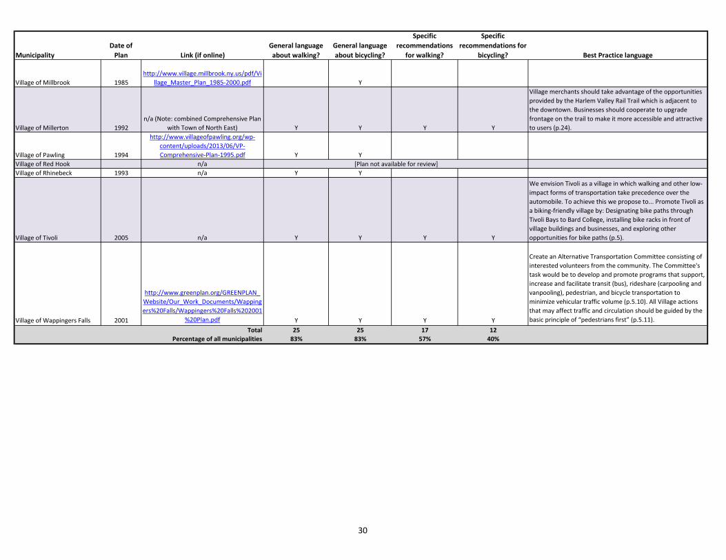
F. Local Comprehensive Plans The local comprehensive plan serves as the long-range vision for a community. As such, the comprehensive plan can provide important guidance on a community’s goals and values, including the role of walking and bicycling in creating a complete transportation system. Planning Department staff reviewed the available comprehensive plans for all municipalities in the county and inventoried what each plan says about walking and bicycling. Overall, 25 of the 30 municipalities discuss walking generally and 25 discuss bicycling generally; 17 include specific recommendations related to improving conditions for walking, and 12 include specific recommendations related to improving conditions for bicycling. A table summarizing these findings and highlighting best practice language from the plans is included below. G. Local Codes While the comprehensive plan outlines a community’s vision, the municipal code details specific requirements and laws to implement that vision. Staff reviewed the local codes of all 30 Dutchess County municipalities related to sidewalk requirements, maintenance, and liability, as well as bicycling laws and Complete Streets policies. Overall findings are summarized below (note that some codes do not specify maintenance responsibilities or other
issues). Information related to maintenance practices based on a survey of local Highway Superintendents can be found in Chapter 4. Zoning Purposes: • Almost half (14) of the local zoning codes state that part of the
purpose of zoning is to encourage walking, while five of the municipalities’ codes state that part of the purpose of zoning is to encourage bicycling.
Sidewalk Locations: • 15 municipalities’ codes (50 percent) require sidewalks on all
streets, unless waived by the Planning Board. • 8 municipalities’ codes (27 percent) require sidewalks only on
certain streets or in certain areas. • 13 municipalities’ codes (43 percent) leave the decision of
whether to require sidewalks (or sidewalks in areas beyond those specified) up to the Planning Board.
Maintenance: • 8 municipalities’ codes (27 percent) specifically require
property owners to maintain adjacent sidewalks. • 6 of those 8 municipalities’ codes (20 percent) provide for a
lien or charge to be assessed to the property owner if they do not repair sidewalks within a reasonable period.
• 20 municipalities’ codes (67 percent) specifically require property owners to remove snow and ice from adjacent sidewalks.
• 10 of those 19 municipalities’ codes (33 percent) provide for a lien or charge to be assessed to the property owner if they do not remove snow and ice within a reasonable period.
26

Walk Bike Dutchess
Chapter 2: Federal, State and Local Guidance Effective March 27, 2014
Liability: • 21 municipalities’ codes (70 percent) require prior written
notice of a sidewalk defect and a failure to respond in order for the municipality to assume liability.
• 4 municipalities’ codes (13 percent) state that the adjacent property owner may be liable for defects in the sidewalk.
Bicycling on Sidewalks: • 3 municipalities’ codes (10 percent) prohibit bicycling on some
or all sidewalks. Complete Streets: • Currently, only the Town of Fishkill has a Complete Streets
policy. However, it has not yet been incorporated into the Town code (see Chapter 7 for more information).
A table summarizing these findings is included below.
27

DUTCHESS COUNTY MUNICIPALITIESComprehensive Plan Review
MunicipalityDate of
Plan Link (if online)General language
about walking?General language about bicycling?
Specific recommendations
for walking?
Specific recommendations for
bicycling? Best Practice language
City of Beacon 2007http://www.cityofbeacon.org/files/compr
ehensive-plan-adopted-2007dec.pdf Y Y Y Y
Continue to develop a continuous Fishkill Creek Trail... Coordinate with neighboring municipalities to enhance access and linkages to and provide for continuation of the trail (p.96).
City of Poughkeepsie 1998http://www.cityofpoughkeepsie.com/dow
nload/121/ Y Y
Main Street should function as a traditional downtown, with its primary role as a central business corridor, easily accessible to and navigable by pedestrian and vehicular traffic (p.2-2).
Town of Amenia 2007
http://www.ameniany.gov/docs/doc_download/576-comprehensive-plan-update-7-
20-07.html
Town of Beekman 2011
http://www.townofbeekman.com/vertical/sites/%7B45AD6F45-1C6B-43EE-A091-
A602A0E0E2B6%7D/uploads/Plan_-_Comprehensive_Plan.pdf Y Y
Prepare a “Detailed Pedestrian Access Master Plan” for new, reconstructed and/or improved sidewalks and existing crosswalks. The Plan should include existing uses, development patterns, and traffic patterns supportive of sidewalks and crosswalks (p.27).
Town of Clinton 2012http://www.townofclinton.com/wp-
content/uploads/Summary.pdf
Town of Dover 1993http://townofdoverny.us/uploads/0Introd
uction.pdf Y Y
Town of East Fishkill 2002http://www.eastfishkillny.org/sites/defaul
t/files/2002%20Master%20Plan.pdf Y Y Y Y
Install bicycle parking facilities at the Hopewell Junction commercial area, Town Hall, the town park-and-ride lots and town recreational areas such as the Hopewell Recreation Area (p.56).
Town of Fishkill 2009
http://www.fishkill-ny.gov/pdfs/2009%20Comprehensive%20PLan/TOF%20Comprehensive%20Plan%20-
%20Adopted%209-23-09.pdf Y Y Y
Amend the Zoning and Subdivision regulations to require that all new site plan and subdivision applications include provisions for “complete streets” with sidewalks, pedestrian paths and, where appropriate, bicycle lanes. Sidewalks should be provided where density is appropriate (generally ½ acre lots or smaller), where they connect people with destinations and can provide a pleasant experience, and where they link to other sidewalks (p.18).
Town of Hyde Park 2005http://www.hydeparkny.us/Zoning/FinalC
omprehensivePlan7-11-05.pdf Y Y Y
Where streams and other waterways traverse the Town, pedestrian rights-of-way should be sought, and public pathways developed. This is particularly appropriate where such waterways provide linkages between the Neighborhoods, Hamlets, Town Center and Business Districts (p. 74).
Town of LaGrange 2005 n/a Y YTown of Milan 2007 n/a Y Y Y
Town of North East 1992 n/a Y Y Y Y
Just as a network of roads is necessary to an area, a network of trails linking open spaces, recreation areas and community facilities is necessary for pedestrian movement, recreational activities, and a coordinated approach to link various land uses in a community. Trails can serve the following purposes: Link parts of Town and Village; link areas to Rail Trail; link Village Center to adjacent areas; link stream corridors; link the Village with Rudd Pond; Utility Corridors; Encourage multiple-use trails in and around the village (p.58).
28

MunicipalityDate of
Plan Link (if online)General language
about walking?General language about bicycling?
Specific recommendations
for walking?
Specific recommendations for
bicycling? Best Practice language
Town of Pawling 2012
http://www.pawling.org/Pages/PawlingNY_CompPlan/1%20Adopted%20Pawling%2
0CPU%20071112.pdf Y Y Y Y
The metropolitan transportation plan promotes completion of a Greenway Trail along the unused railbed from Hopewell Junction through Pawling and then south to the Putnam County line (p.75).
Town of Pine Plains 2004
http://pineplains-ny.gov/content/Generic/View/7:field=documents;/content/Documents/File/536.pdf Y Y Y Y
Use techniques such as… street trees, delineated pedestrian islands, and “bulb-outs” of sidewalks in order to work with NYS DOT and the Pine Plains Highway Dept to implement traffic calming (p.58).
Town of Pleasant Valley 2009http://pleasantvalley-
ny.gov/comprehensive-plan/ Y Y Y Y
Adopt zoning regulations about the inclusion of pedestrian amenities such as sidewalks, public recreational facilities, benches, bike racks, and crosswalks as part of the review process (Section 5.4).
Town of Poughkeepsie 2007
http://www.townofpoughkeepsie.com/supervisor/poughkeepsietownplanadopted0
92607.pdf Y Y Y Y
There are a number of potential trail projects in the Town. An abandoned rail spur splits off from the Maybrook line at Morgan Lake, passes Peach Hill, and continues into the Town of Hyde Park and on to Pleasant Valley where it meets West Road Elementary School and the adjacent Redl Park (p.44-45).
Town of Red Hook 1993 n/a Y Y
Requir[e] safe pedestrian access in the design of all commercial sites, and further requir[e] service roads, combined parking areas, and strong pedestrian linkages between individual establishments within areas of concentrated business activity (p.14).
Town of Rhinebeck 2009
http://www.greenplan.org/GREENPLAN_Website/Our_Work_Documents/Rhinebeck/The%20Rhinebeck%20Plan%20Complet
e.pdf Y Y
Town of Stanford 2012http://www.caryarchive.org/stanford_ma
sterPlan_draft.pdf Y Y
Create a Planned Development Overlay (PDD) District in Stanfordville. The overlay district could be used as a tool to encourage the development of a walkable mixed-use center, concentrating future development south of Town Hall (p.42).
Town of Union Vale 2001http://www2.marist.edu/Unionvale/HdM
aster.htm Y Y
Town of Wappinger 2010
http://www.townofwappinger.us/pdf/comp_plan/Wappinger%20Comp%20Plan%2
010-9-27.pdf Y Y Y Y
Develop a staged Pedestrian and Bikeway Master Plan that inventories and evaluates existing and potential facilities and improvements. Review and expand requirements for the provision of sidewalks in conjunction with new commercial development (p.59).
Town of Washington 2012 (Draft)
http://comp.washingtonny.org/wp-content/uploads/Comp-Plan-Final-Version-
2.pdf Y Y
Village of Fishkill 2009
http://www.vofishkill.us/sites/default/files/documents/comprehensive-
plan/web/binder_lettersize_wholereport.pdf Y Y Y
The best means to reduce congestion in the Village is to support and promote alternative forms of transportation, namely pedestrian and bicycle... There are some areas that remain un-sidewalked or where there are missing connections. The Village should look to solidify this network by extending existing sidewalks and by providing new sidewalks where connections are missing (p.28).
29
MunicipalityDate of
Plan Link (if online)General language about walking?
General language about bicycling?
Specific recommendations
for walking?
Specific recommendations for
bicycling? Best Practice language
Village of Millbrook 1985http://www.village.millbrook.ny.us/pdf/Vi
llage_Master_Plan_1985-2000.pdf Y
Village of Millerton 1992n/a (Note: combined Comprehensive Plan
with Town of North East) Y Y Y Y
Village merchants should take advantage of the opportunities provided by the Harlem Valley Rail Trail which is adjacent to the downtown. Businesses should cooperate to upgrade frontage on the trail to make it more accessible and attractive to users (p.24).
Village of Pawling 1994
http://www.villageofpawling.org/wp-content/uploads/2013/06/VP-Comprehensive-Plan-1995.pdf Y Y
Village of Red Hook n/aVillage of Rhinebeck 1993 n/a Y Y
Village of Tivoli 2005 n/a Y Y Y Y
We envision Tivoli as a village in which walking and other low-impact forms of transportation take precedence over the automobile. To achieve this we propose to... Promote Tivoli as a biking-friendly village by: Designating bike paths through Tivoli Bays to Bard College, installing bike racks in front of village buildings and businesses, and exploring other opportunities for bike paths (p.5).
Village of Wappingers Falls 2001
http://www.greenplan.org/GREENPLAN_Website/Our_Work_Documents/Wappingers%20Falls/Wappingers%20Falls%202001
%20Plan.pdf Y Y Y Y
Create an Alternative Transportation Committee consisting of interested volunteers from the community. The Committee's task would be to develop and promote programs that support, increase and facilitate transit (bus), rideshare (carpooling and vanpooling), pedestrian, and bicycle transportation to minimize vehicular traffic volume (p.5.10). All Village actions that may affect traffic and circulation should be guided by the basic principle of “pedestrians first” (p.5.11).
Total 25 25 17 12Percentage of all municipalities 83% 83% 57% 40%
[Plan not available for review]
30

DUTCHESS COUNTY MUNICIPALITIESLocal Codes Inventory
City
of B
eaco
n
City
of P
ough
keep
sie
Tow
n of
Am
enia
Tow
n of
Bee
kman
Tow
n of
Clin
ton
Tow
n of
Dov
er
Tow
n of
Eas
t Fish
kill
Tow
n of
Fish
kill
Tow
n of
Hyd
e Pa
rk
Tow
n of
LaG
rang
e
Tow
n of
Mila
n
Tow
n of
Nor
th E
ast
Tow
n of
Paw
ling
Tow
n of
Pin
e Pl
ains
Tow
n of
Ple
asan
t Val
ley
Tow
n of
Pou
ghke
epsie
Tow
n of
Red
Hoo
k
Tow
n of
Rhi
nebe
ck
Tow
n of
Sta
nfor
d
Tow
n of
Uni
onva
le
Tow
n of
Wap
ping
er
Tow
n of
Was
hing
ton
Villa
ge o
f Fish
kill
Villa
ge o
f Mill
broo
k
Villa
ge o
f Mill
erto
n
Villa
ge o
f Paw
ling
Villa
ge o
f Red
Hoo
k
Villa
ge o
f Rhi
nebc
ek
Villa
ge o
f Tiv
oli
Villa
ge o
f Wap
ping
ers F
alls
Tota
l Num
ber
Ove
rall
Perc
enta
ge
Zoning Purposes: Encourage Walking Y Y Y Y Y Y Y Y Y Y Y Y Y Y 14 47%Zoning Purposes: Encourage Bicycling Y Y Y Y Y 5 17%
SidewalksLocations: All Streets, Unless Waived Y Y Y Y Y Y Y Y Y Y Y Y Y Y Y 15 50%Locations: Certain Streets/Areas Only Y Y Y Y Y Y Y Y 8 27%Locations: As Required by Planning Board Y Y Y Y Y Y Y Y Y Y Y Y Y 13 43%Maintenance: By Property Owner Y Y Y Y Y Y Y Y 8 27%Maintenance: Local Assessment Y Y Y Y Y Y 6 20%Snow/Ice Removal: By Property Owner Y Y Y Y Y Y Y Y Y Y Y Y Y Y Y Y Y Y Y Y 20 67%Snow/Ice Removal: Local Assessment Y Y Y Y Y Y Y Y Y Y 10 33%Liability: Prior Written Notice Required Y Y Y Y Y Y Y Y Y Y Y Y Y Y Y Y Y Y Y Y Y 21 70%Liability: Property Owner Y Y Y Y 4 13%
Bicycling: Prohibited on Sidewalks Y~ Y Y 3 10%
Complete Streets Policy Y^ 1 3%~: On Main Street only.^: Separate policy; not yet in Town Code. Sam 2 3 4 5 6 7 8 9 10 11 12 13 14 15 16 17 18 19 20 21 22 23 24 25 26 27 28 29 30 31 32
31