Embed Size (px)
Citation preview

WALK AND ROLL WESTLAND: PEDESTRIAN AND BICYCLE SAFETY ACTION PLAN
7/7/2021 1 Tech Memo 1: Corridor Identification
Tech Memo 2 – Non-Motorized Route Identification
Introduction Following the existing conditions analysis, the potential locations of new non-motorized facilities began to emerge. In this phase of the planning process, the project stakeholders and the public were engaged to gather input on where they currently walk and ride their bikes, what destinations they would like to go to by walking or biking, and where in Westland there are gaps in safety, comfort, and facilities. A project Stakeholder Committee meeting was held in April 2021 to review the project, develop goals, and understand where people are currently walking and biking in the City. Following the Stakeholder Committee meeting, an online public input survey was created and distributed to the community to gather ideas about new walking and biking resources. Additionally, a public meeting was held via Zoom to discuss with residents the goals for the project.
Public Engagement Summary Steering Committee Meeting Summary The project Steering Committee consists of Westland City staff members, local planning agency staff members, Westland residents, and other community stakeholders. The goal of the Steering Committee is to help guide the project and provide input on the project’s recommendations. The first Steering Committee meeting was held on April 14th, 2021. The goals and priorities from the Steering Committee include the following:
• Fill sidewalk gaps around the City improving conditions for pedestrians, and enhancing crosswalks. • Use new non-motorized facilities to help connect the trail system to the regional network. • Provide wayfinding to specific regional trails. • Ensure that trails and new non-motorized facilities are not negatively impacting the environment • Prioritize safety for all users. • Connect new facilities to planned and existing greenways and blueways.
Public Meeting Summary The first public meeting was held on May 11, 2021 at 5:30 pm through Zoom. Members of the public, City leadership, neighborhood organizations, residents, and bicycle and walking advocates were in attendance. The meeting began with an overview on the project, its purpose, and existing conditions. Meeting participants then were led through a discussion, centered around the following questions.
1. Where do you currently walk and bike in Westland? a. Answers include:
i. Neighborhoods ii. Warren Ave iii. Westland south of Ford iv. Westland Mall v. Northville vi. Plymouth vii. Norwayne viii. Marquette

WALK AND ROLL WESTLAND: PEDESTRIAN AND BICYCLE SAFETY ACTION PLAN
7/7/2021 2 Tech Memo 1: Corridor Identification
b. Central City (x3) c. Cowan (x2) d. Parks in General (x2) e. Hines Drive/Park (x2)
2. Which areas of Westland are most UNSAFE for bicyclists and pedestrians? a. Answers include:
i. Grand Traverse ii. Central City Parkway iii. Hix road between Ford and Joy iv. Ford and Wayne v. Newburgh vi. Fountain and Joy Intersection vii. Merriman and Venoy Intersection viii. Cherry Hill and Wayne Intersection ix. Warren and Merriman Intersection x. Wayne and Ford Road Intersection xi. Wayne and Hunter Intersection
3. Where would you like to be able to walk and bike in Westland? a. Answers include:
i. Tattan Park ii. Ann Arbor Trail iii. Shop and dine district iv. Meijer v. Henry Ruff vi. Central City Parkway vii. Hines Park viii. Library
4. What other walking and biking improvements would you like to see come out of this study? a. Answers include:
i. Road and sidewalk improvements would benefit more people. If it's out of the scope of this project and all you want to do is make bike lanes, then this has very limited benefit at least to me.
ii. Sidewalk gaps iii. Safety Information and Skills Workshops (x2) iv. Crossing walk enhancements, timing, equipment, paint v. Public bike racks (x2) vi. Clear crosswalks and signage vii. Lighting, education, and bike racks (x2)
Public Input Survey Summary With a total of 45 responses, the Walk and Roll Westland Community survey was launched on the week of April 12th and was made available online for 6 weeks. The following statements describe the majority of those who walk and bike in Westland.

WALK AND ROLL WESTLAND: PEDESTRIAN AND BICYCLE SAFETY ACTION PLAN
7/7/2021 3 Tech Memo 1: Corridor Identification
• The majority of respondents walk and/or bike in Westland a few times a week for the purpose of personal fitness or exercise. A great number of people also travel for leisure.
• Respondents typically walk more than bike in Westland. • Most respondents ride their bicycle on the street and walk on the sidewalk most often. • Respondents most like biking and walking in Westland for the opportunity to enjoy nature and
because they live near places to ride their bike • When biking in Westland, the top challenges bikers face are not enough pathways and bike lanes, and
heavy or speeding traffic. • When walking in Westland, the top challenges walkers face are not enough sidewalks and pathways
and poor sidewalk quality. • A number of respondents felt that better lighting, more sidewalks, improved crosswalks, designated
bike lanes would make them feel more comfortable walking and/or biking in Westland. • When walking and/or biking in Westland, the majority of respondents travel to parks, civic buildings,
and shopping. Specific destinations include places such as City Hall, Hines Park, Meijer, Library, Tattan Park, the Shop and Dine District, and Central City Park.
• Many would like to see Newburgh, Warren, Merriman, Ford, and Wayne Road become more pedestrian or bicycle friendly.
Route Identification Process Utilizing the input collected from the community and project stakeholders, and the existing conditions analysis, potential routes were identified. The consultant team performed an internal route brainstorming exercise, and a similar exercise was held with the Stakeholder Committee. Routes and corridors identified by the public through the public meeting and online survey were also collected.

WALK AND ROLL WESTLAND: PEDESTRIAN AND BICYCLE SAFETY ACTION PLAN
7/7/2021 4 Tech Memo 1: Corridor Identification
Project Team Brainstorming Utilizing the existing conditions analysis, OHM Advisors was able to begin to identify primary and secondary routes, along with intersections that could benefit from improvements. The understanding of traffic volume, existing activity centers, equity population distribution, and other important factors from the existing conditions analysis allowed the project team to identify potential non-motorized routes. These connections include the northern and southern portions of Westland along Central City Pkwy from Warren Rd, through Central City Park and John Glenn High School, down to Palmer Rd. Important east-west connections include from Central City Pkwy to the Westland city boundary along Hunter Ave and Marquette St. Other important connections along Venoy Rd and Avondale St also have the potential to be important neighborhood connections. Additional secondary connections highlighted include potential connections to other important neighborhoods in the southeast of the city, as well as a connection to regional trails such as the I-275 Metro Trail. Intersections highlighted as needing improvements were largely identified along main roads such as multiple Wayne Rd intersections, as well as access points to Hines Dr and other important neighborhood entry points along Venoy Rd.

WALK AND ROLL WESTLAND: PEDESTRIAN AND BICYCLE SAFETY ACTION PLAN
7/7/2021 5 Tech Memo 1: Corridor Identification
Steering Committee Route Ideas A similar exercise was conducted with the Steering Committee, and the group was also able to identify some important routes and intersections given their knowledge of the community and as local pedestrians and cyclists. The Steering Committee identified similar routes as the project team, such as the primary connection from Hines Dr, along Cowan Rd, and along Central City Pkwy down to Palmer Rd. A similar east-west connection was identified along Marquette St. Routes through the Norwayne neighborhood and connecting to the commercial centers along Ford Rd and Wayne Rd were also identified. Potential intersection improvements were concentrated along the Central City Pkwy route, as well as intersections along Merriman Rd and within the neighborhoods.
WALK AND ROLL WESTLAND: PEDESTRIAN AND BICYCLE SAFETY ACTION PLAN
7/7/2021 6 Tech Memo 1: Corridor Identification
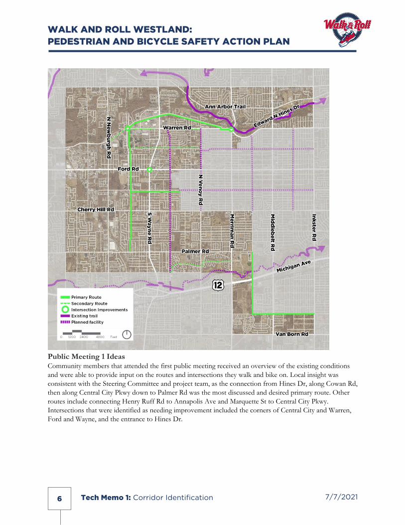
Public Meeting 1 Ideas Community members that attended the first public meeting received an overview of the existing conditions and were able to provide input on the routes and intersections they walk and bike on. Local insight was consistent with the Steering Committee and project team, as the connection from Hines Dr, along Cowan Rd, then along Central City Pkwy down to Palmer Rd was the most discussed and desired primary route. Other routes include connecting Henry Ruff Rd to Annapolis Ave and Marquette St to Central City Pkwy. Intersections that were identified as needing improvement included the corners of Central City and Warren, Ford and Wayne, and the entrance to Hines Dr.

WALK AND ROLL WESTLAND: PEDESTRIAN AND BICYCLE SAFETY ACTION PLAN
7/7/2021 7 Tech Memo 1: Corridor Identification
Community Survey Ideas The community survey reinforced previous routes such as the Hines-Cowan-Central City connection, but also brought to light potential routes along Newburgh Rd and Cherry Hill Rd. Warren Rd, which was identified as a secondary route in previous exercises, was identified as a potential primary route. Connections to Annapolis Ave and the southeastern portion of the city were also reinforced through survey results. The Hines Dr intersection, as well as intersections along Venoy and Wayne, were noted as needing improvement.

WALK AND ROLL WESTLAND: PEDESTRIAN AND BICYCLE SAFETY ACTION PLAN
7/7/2021 8 Tech Memo 1: Corridor Identification
Results of Brainstorming When combining the results from the various brainstorming sessions and feedback methods, the popular primary and secondary routes begin to emerge. The intersections most in need of safety improvements also appear.

WALK AND ROLL WESTLAND: PEDESTRIAN AND BICYCLE SAFETY ACTION PLAN
7/7/2021 9 Tech Memo 1: Corridor Identification
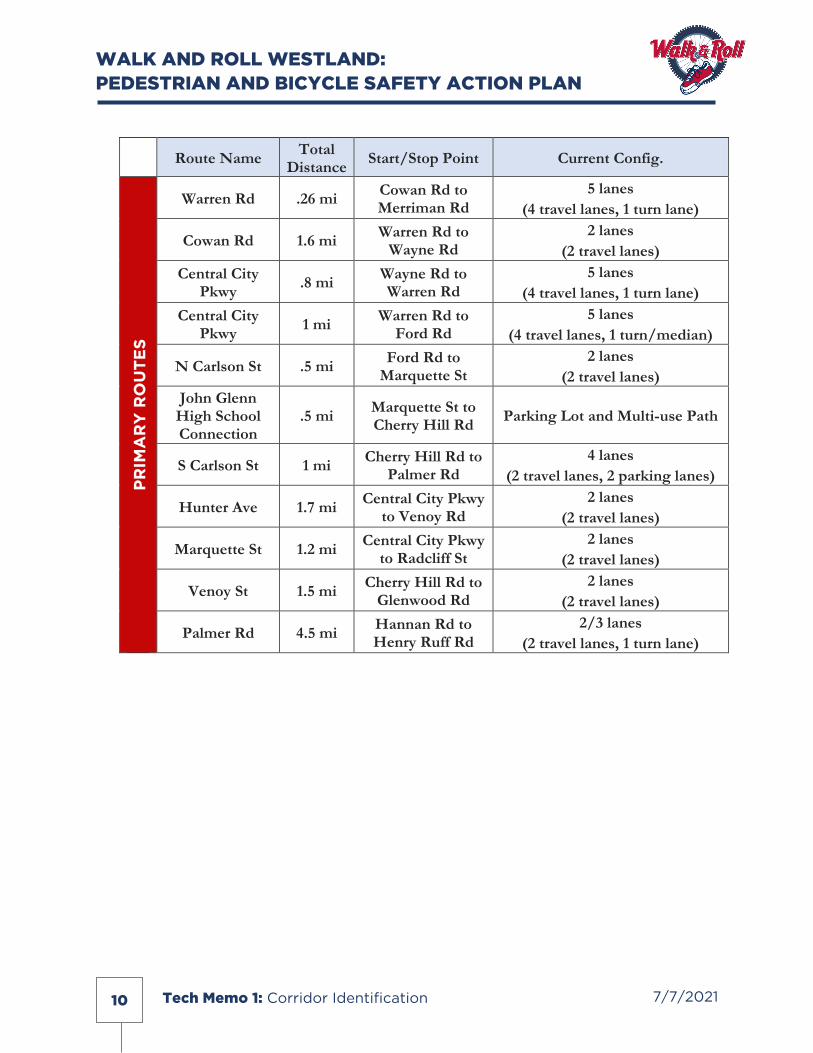
Primary and Secondary Corridors Primary and secondary routes identified are results of the brainstorming exercises and the consensus built around important city connections. Routes include north-south and east-west connections that connect Westland’s neighborhoods to important community assets such as city parks, regional trails, shopping and retail districts, and local schools. Important intersections are cross streets identified as needing improvements based on proximity to primary routes and relation to regional routes. Routes and intersections are listed below:
WALK AND ROLL WESTLAND: PEDESTRIAN AND BICYCLE SAFETY ACTION PLAN
7/7/2021 10 Tech Memo 1: Corridor Identification
Route Name Total Distance Start/Stop Point Current Config.
PR
IMA
RY
RO
UTE
S
Warren Rd .26 mi Cowan Rd to Merriman Rd
5 lanes (4 travel lanes, 1 turn lane)
Cowan Rd 1.6 mi Warren Rd to Wayne Rd
2 lanes (2 travel lanes)
Central City Pkwy .8 mi Wayne Rd to
Warren Rd 5 lanes
(4 travel lanes, 1 turn lane) Central City
Pkwy 1 mi Warren Rd to Ford Rd
5 lanes (4 travel lanes, 1 turn/median)
N Carlson St .5 mi Ford Rd to Marquette St
2 lanes (2 travel lanes)
John Glenn High School Connection
.5 mi Marquette St to Cherry Hill Rd Parking Lot and Multi-use Path
S Carlson St 1 mi Cherry Hill Rd to Palmer Rd
4 lanes (2 travel lanes, 2 parking lanes)
Hunter Ave 1.7 mi Central City Pkwy to Venoy Rd
2 lanes (2 travel lanes)
Marquette St 1.2 mi Central City Pkwy to Radcliff St
2 lanes (2 travel lanes)
Venoy St 1.5 mi Cherry Hill Rd to Glenwood Rd
2 lanes (2 travel lanes)
Palmer Rd 4.5 mi Hannan Rd to Henry Ruff Rd
2/3 lanes (2 travel lanes, 1 turn lane)

WALK AND ROLL WESTLAND: PEDESTRIAN AND BICYCLE SAFETY ACTION PLAN
7/7/2021 11 Tech Memo 1: Corridor Identification
Route Name Total Distance Start/Stop Point Current Config.
Seco
ndar
y R
out
es Holiday Nature
Preserve Trail 4.7 mi Ann Arbor Trail to I-275 Metro Trail @ Koppernick Rd
N/A
Warren Rd 1.6 mi Cowan Rd to Central City Pkwy
5 lanes (4 travel lanes, 1 turn lane)
Cherry Hill Rd 4.5 mi Superior Pwky to Henry Ruff Rd
2/5 lanes (4 travel lanes, 1 turn lane)
Henry Ruff Rd 2.5 mi Cherry Hill Rd to Annapolis Ave
2/3 lanes (2 travel lanes, 1 parking lane)
N-S Cross Street E-W Cross Street Current Config.
Inte
rsec
tio
n Im
pro
vem
ents
Merriman Rd Warren Rd Painted crosswalks and sidewalks
Wayne Rd Central City Pkwy Painted crosswalks and sidewalks
Central City Pkwy Warren Rd Painted crosswalks and pedestrian
landing
Wayne Rd Ford Rd Painted crosswalks and sidewalks
Venoy Rd Cherry Hill Rd Painted crosswalks and sidewalks