Embed Size (px)
Citation preview

Fang Oilfield Development
Nopparat SETTAKUL
School of Engineering and Resources Management, Walailak University, Nakhon Si Thammarat 80161, Thailand
(E-mail: [email protected])
ABSTRACT
Fang Oilfield is the oldest oilfield in Thailand and is still producing
oil. The first oil seepage was found on the ground surface in the dense jungle over a hundred years ago by local inhabitants. The oilfield has been investigated by pioneer explorers from different government sectors involved in oil exploration and production but is still far away from being economically viable. When the Defense Energy Department (DED) took responsibility for the site in 1956, a new era of modern technologies of geological survey, 3-D seismic survey, and directional drilling wells have been seriously applied. From a gallon to a thousand barrels of oil daily production has significantly increased. The oil discovery in Fang basin encourages further activities in petroleum exploration both onshore and offshore in Thailand. Today, Thailand can produce oil and gas equivalent to 300,000 barrels of oil daily, close to 30 % of national consumption. The history and current activities of the oilfield are still of interest to the public. This paper intends to integrate available data from the first era to the present day to explore the nature of this small oilfield.
Keywords: Fang Oilfield, geological survey, directional drilling wells, 3-D seismic survey, petroleum exploration
INTRODUCTION
The Fang Oilfield is located in Fang intermontane basin, Northern Thailand. It is approximately 150 km north of Chiang Mai or 850 km from Bangkok, the capital of Thailand. The surface area is approximately 600 km2 (W 12 × L 50 km), probably the smallest intermontane basin in which petroleum has been discovered in the country. The basin lies NE-SW with an elongated shape and is surrounded by older formations of rocks from Cambrian and Igneous rocks to more recent sediments (Figure 1). The highest peak is around 2,000 m and the basin is about 450 m above mean sea level [1,2].
Walailak J Sci & Tech 2009; 6(1): 1-15.
MINIREVIEW ARTICLES

2
Figure 1 Geomorphology and geologic setting of the Fang basin.
People living in the area are Thai citizens and also more than 10 groups of minority hill tribes including Chinese, Mong, Muser, E-koe, Palong, Dai Yai, Karen, Yao, Wa, Lisor and local northern people with different dialects and cultures.
The area is hilly with green mountain forest and beautiful nature. As such, Fang is one of the most attractive places for both Thai and foreign tourists who visit all year long. During December and January, some days the temperature might drop down to 5 - 10 °C and sometimes even as low as 0 °C on the peak of Doi Angkang. Such climatic conditions are rarely found in other places of the country.
Agriculture and commerce are the main economies in the region. Among most popular fruits from this area are lychees and honey oranges which are very tasty. On the top of Doi Angkang where the Royal King’s project station is located, many plants, floras and vegetables from cold countries are planted aimed at reducing drug activities previously common in the area.
N SETTAKUL
3
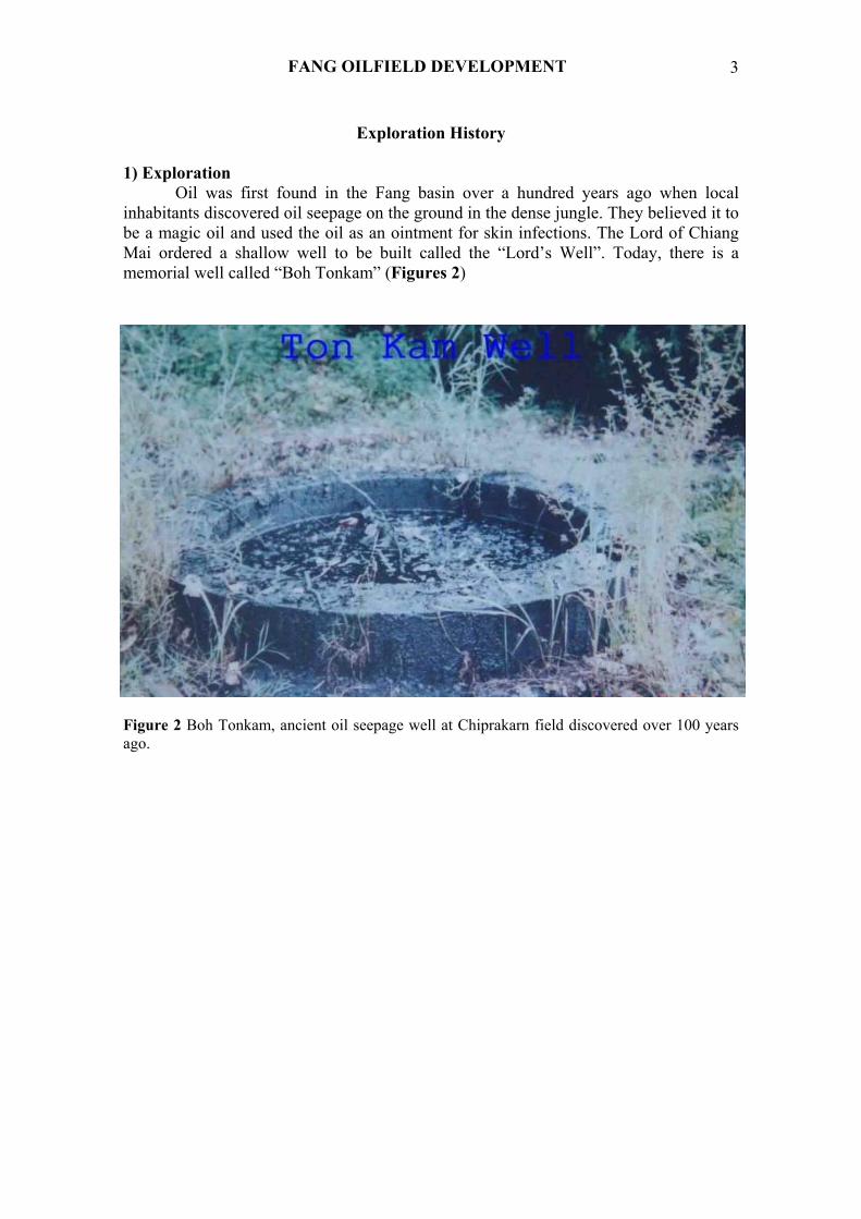
Exploration History 1) Exploration
Oil was first found in the Fang basin over a hundred years ago when local inhabitants discovered oil seepage on the ground in the dense jungle. They believed it to be a magic oil and used the oil as an ointment for skin infections. The Lord of Chiang Mai ordered a shallow well to be built called the “Lord’s Well”. Today, there is a memorial well called “Boh Tonkam” (Figures 2) Figure 2 Boh Tonkam, ancient oil seepage well at Chiprakarn field discovered over 100 years ago.
FANG OILFIELD DEVELOPMENT

4
Figure 3 General Pra Kampaengphet (right) and Mr. Wallace Lee (left), pioneer explorers sitting on the giant logs at Fang (1921).
In 1921, General Pra Kampangphet Akkarayothin (HM) (Figure 3), the Director General of the Royal State Railway Department and a US geologist, Mr. Wallace Lee conducted a geological survey and drilled 2 shallow wells with a steam engine drilling rig in 1922 but these wells were dry and abandoned.
March 9th 1958, His Majesty the King and Queen of Thailand paid a visit to the
oil field and ceremonially spud the Well F 15. They spent a night there to visit local people (Figure 4) [3,4].
N SETTAKUL

5
(a)
(b) Figure 4 His Majesty King Bhumipol and Queen Sirikit visited and ceremonially spud the well of Chiprakarn field (1958).
FANG OILFIELD DEVELOPMENT

6
2) Drilling A total of over 240 wells have been recorded since the first drilling well started
in the Fang basin over 40 years ago. The wells are from different locations. Now only 5 locations are producing oil and 2 fields have been abandoned. 3) Production
The total production from the Fang basin is approximately 9 million barrels (MMBbl) from the following 7 reservoirs since early 1960 to the present day. I. Chaiprakarn Reservoir (abandoned 1984), II. Maesoon Reservoir, III. Pongnok Reservoir (abandoned 1985), IV. Sansai Reservoir, V. Nongyao Reservoir, VI. Sanjang Reservoir, VII. Banthi Reservoir [5-7].
The latest Banthi reservoir was discovered from 3-D seismic interpretation in 2001 [8]. A total of 7 wells were drilled, 3 wells were directional wells. Five wells are producing at a rate of 150 BOD. The seismic section across the Fang basin shows complex structures, fault systems and potential traps (Figure 5) and the isochrone map shows the reservoirs are delimited by a system of normal faults (Figure 6)
.
Figure 5 Seismic cross section shows structures, faulted system and potential traps.
N SETTAKUL

7
Figure 6 Isochrone map of Banthi structure.
Geologic Setting The Fang basin is approximately 25 - 40 million years old and with layers in the
Oligocene period. It is as deep as 10,000 ft in the deepest part of the basin. The lithologic assemblage is related to an episode of extension. Rifting started over 20 million years ago when the thick sequences of lacustrine sediments were deposited during the Miocene period. This sequence is called Maesod formation. Subsequent tectonic activity resulted in the deposition of thick sequences of coarse alluvial sediments that unconformably overlay the lacustrine sequences. This tectonic activity may be broadly related to changes in tectonic stress patterns caused by the progressive Indo-Eurasian collision. The coarse clastics are termed Maefang formation and possibly span the latter Miocene to the Pliocene-Pleistocene period [5].
Subsurface Structure Internally, the Fang basin can be divided into 3 extensional sub-basins as
interpreted from gravity and seismic surveys. These sub-basins are postulated by first
FANG OILFIELD DEVELOPMENT

8
order Riedel shear faults. The Riedel shears are clearly visible on satellite images cutting across Pre-Tertiary basements surrounding the Fang basin. These shears result from left lateral shear coupled with movement that initiated the basin. Within the sub-basins, there occurs a swarm of cross-basin faults which are parallel with the Riedel shears; these are interpreted as coincident second order Riedel shears. The interpretation is based partly on the extensive network of seismic profiles across the Huai Ngu sub-basin.
Subsurface Lithostratigraphy From the geological data there are 2 major formations from the upper zone of
Maefang formation to lower zones of Maesod formation as follows: Maefang Formation (Quaternary + Recent)
The post-rift of Maefang formation overlies discordantly above the Maesod formation. The thickness of the Maefang formation from the surface varies from 1,000 - 1,800 ft. The minimum thickness is found on top of the Maesoon structure. The thickness will increase down dip from the crest of the structure.
Maefang formation is mainly composed of coarse clastic sediments of soil, lateritic sands, loose sands, gravels, cobbles and pebbles, carbonized woods and clay on the top and towards the basin edge. Sizes of sands vary from coarse to very coarse grains, roundness from angular to subangular, poorly sorted and interbedded with reddish clays. While down dip towards the central basin clay-shale and arkosic sandstone are interbedded. This formation overlies discordantly with the Maesod formation. The Maefang formation shows energetic alluvial and fluvial deposits. Maesod Formation (Middle Tertiary)
The Maesod formation is composed of brown to gray shale, yellowish mud stone generally interbedded with sand and sandstone with a series of channels of sand paleodelta and fluvial sand.
Basal conglomerate lies unconformity with Pre-Tertiary rocks and continues with sequences of lacustrine shale and mudstone. The color of the sediments indicates a reducing environment in the central, deeper part of the basin while an oxidizing environment develops in the shallow part of basin. Organic shale in the central part of the basin plays an important role as a potential source of rocks. The upper part of the Tertiary sediments is interbedded with 4 packages of sand which are important reservoir rocks in the Fang basin. Only 2 packages of sands have been proven to be producing sands. The sand thickness varies from 1 - 10 m.
The thickness of the Maesod formation varies from the margin of the basin towards the centre of the basin. At the Maesoon structure the thickness is approximately 3,500 ft or total thickness (Maefang + Maesod formation) 5,000 ft from the surface. Seismic interpretations indicate that the thickest part of the Maesod formation might reach up to 8,000 ft at the deepest part of the basin.
N SETTAKUL

9
Basement (Pre-Tertiary) The age of the basement of the Fang basin ranges from Mesozoic continental
clastics to Cambrian marine clastics.
Environment of Deposition The Maesod Formation was laid down following initial basin rifting in the later
Oligocene or early Miocene periods. Sands and shale alternate in the lower part of the formation indicating a fluvial to shallow lacustrine environment of deposition. This lower sequence is capped by a 75 - 100 ft lignite seam indicating a change in environment to swamps and peat bogs for a period of time. The upper portion of the Maesod is dominated by organic rich shale with minor sandstone beds occurring, especially in the lower part of the upper section. This lithology indicates a lacustrine dominated environment following the deposition of the peat. The Maesod formation is then overlain by the coarse clastic dominated Maefang formation, returning to a more fluvial tile dominated environment. The Maefang is not considered a viable rock source because of its dominant sandy lithology and shallow, immature depth of burial. The above description is based on the Fang basin but appears to be a valid generalization for most of the Thai Cenozoic intermontane basins.
Petroleum Source Rocks
Source or potential source samples can be found from both outcrops and cores. Oil seepage can be seen near the edge of the basin. The oil found in the Fang basin is most likely from lacustrine shales found in the Maesod formation.
The geochemical analysis of potential source rocks has been done by using cores and cuttings from selected wells of Maesoon and Sansai reservoirs. The analysis indicated very interesting results. Total organic carbons (TOC) are very abundant between 1.12 - 2.67 % with a maximum of 3.03 %. Extraction soluble organic matter (EOM) is as high as 1,646 ppm. Kerogen type III is approximately 20 - 25 %, indicative of a lacustrine paleo-environment. The maturation scale indicates that the top oil window should start below 4,000 ft. While the core indicates that maturation starts from 7,750 ft. Mean vitrinite reflectance (RO %) from core analysis is only 0.44 % at 3,000 ft which is lower than the ideal level of maturation of RO 0.5 - 1.2 % and with a temperature (T max) of 437 - 470 °C in the Fang basin. So, the most favorable source rocks are the Maesod shales which are within and below the oil window [9].
Migration The current producing pay intervals are above the mature source rocks. This
indicates the migration of fluids at certain distances from the source rocks to charge the oil reservoirs above. The contributing factors in the migration path from the depths are fractures and faults along permeable rocks during compaction and compression in the late Tertiary period. From the size of the basin and location of reservoirs and production zones the distance of migration is short. After oil generation, oil might migrate in different directions around to the potential traps. Evidence supporting this statement
FANG OILFIELD DEVELOPMENT

10
comes from biodegradation of oil being found at a very shallow depth in Chaiprakarn and Pongnok reservoirs, both sides of the basin, suggesting migration routes from the depths.
Oil Reservoirs Within the Fang basin, all productions come from the Maesod formation. The
current producing reservoirs are distributed into widespread sections of the sorted sands and coarse clastics in some cases. Reservoir Distribution
Generally, interbedded sand and sandstones in the upper zones of the Maesod formation are dominant reservoir rocks in the Maesoon reservoir and others.
The sand member which gives the lowest production includes 4 layers of sand. The thickness of each sand layer varies from 5 - 45 ft. The depth of this sand is about 2,386 - 2,487 ft which is the main producer of wells. The thickest part of this sand is in a North-South direction. Porosity decreases towards the margin of the reservoir.
The sand member gives the highest production includes 5 sands, 5 - 15 ft in thickness for each sand, with a total thickness of about 55 ft. The depth is about 2,160 - 2,255 ft. Most of the old wells are from this sand 2,300 ft in depth. The thickness of the sand varies from place to place. The trend in thickness North-South is 55 ft and decreasing to 10 - 15 ft at the edge of reservoir. Reservoir Properties
Cores analysis from some wells shows interesting results of porosity up to 25 %, permeability higher than 200 milliDarcy (mD), some loose clastics as high as 2,000 - 3,000 mD found in the well IF 26 (Table 1) [10,11]. Table 1 Reservoir properties.
Fluid Saturation (%) Well Depth (ft)
Permeability(mD)
Porosity (%)(abs) Oil (Sor) Wat (Sw)
Density(gm/cc)
BS - 110 2,755.0 231 25.7 6.1 54.4 2.67 IF - 26 1) 2,581.1 2,390 25.4 17.5 33.0 2.65 2) 2,587.1 3,440 26.7 20.5 34.7 2.64 Fluid Properties
Physical properties of oil from Maesoon, Pongnok and Lankrabreau are quite similar with a very high content of paraffin wax up to 18 % (Table 2).
N SETTAKUL

11
Table 2 Crude oil properties.
Properties Chiprakarn Crude Maesoon Crude Pongnok Crude Lankrabreau Crude
API gravity 16.40 30.8 37.6 38.2 Pout point 65 °F 95 °F 92 °F 90 °F Sulphur (%) 0.28 0.18 016 0.5 Paraffin wax (% wt) - 18 18.62 14.5 - 20 Specific gravity 0.957 0.872 0.873 0.675 - 0.85*
(depending on gas content) Color Brownish black Brownish black Brownish black Brownish black
Reserve Estimation The Maesoon reservoir has produced a total of 7 MMBbl since 1963. Production
started from 100 barrel per day up to nearly 1,000 barrels per day at the peak of production (Table 3). The mature reservoir needs to maintain pressure to extend the life of the reservoir. Table 3 Reserve estimation.
Field Probable (MMBbl) Proven (MMBbl) Recoverable (MMBbl)Maesoon 23.0 - 30.0 10.0 - 15.0 8.00
Sansai 20.0 7.0 3.00
Nongyao 5.0 3.0 2.00
Samjang 5.0 1.5 0.75
Pongnok 6.0 3.0 1.50
Banthi 8.0 3.0 1.50
Chiprakarn 4.5 1.5 1.00
From the decline curve the life of the Maesoon reservoir will terminate in the next 4 - 5 years. Secondary recovery will be needed for this reservoir to prolong production.
FANG OILFIELD DEVELOPMENT

12
Seals Due to the interbedded sand/shale nature of the Maesod formation, the sands are
effectively sealed from each other in a vertical sense by the thick, intervening shale. In the upper part of the Maesod the shale to sand ratio is higher than the lower section. Many of reservoir sands appear to be lateraling continuous over larger distances, allowing for lengthy up dip migration pathways. Up dip structural seals are formed by both stratigraphic and faulting mechanisms.
Traps Combinations of structural and stratigraphic traps are very important at the Maesoon reservoir in the Fang basin. Traps or plays in the Fang basin will reflect its evolution during much of its history as a continental interior subsidence. Traps will thus exclusively involve tension faults as well as unconformities caused by uplift and erosional systems. Proven Traps
Structural traps of rollover anticlines originate from growth faulting and compaction on the Pre-Tertiary basement. The anticlinal axis consists of a NNW-SSE trending conforming to the basin N-S trending, dipping 5 - 10° around the crest. Major faults are characterized by a listric geometry which has resulted in the formation of a rollover structure in the hanging wall of the fault. The major fault identified from seismic interpretations is in the NE-SW direction and dipping 85 °W. The fault is characteristic of a trust and strike slip fault. The western block has moved along the strike south about 150 ft and vertical displacement is about 250 ft. Minor faults are also found associated with the Maesoon and Nongyao reservoirs.
Combination traps of up dip truncation and lithostratigraphic pinchout from porous rocks to impermeable rocks have been proved to exist in Sansai, Pongnok, and Banthi reservoirs along the eastern trend of the Fang basin. In Chaiprakarn, some leakage of oil, probably uplift of the basin and erosion exposed crude oil near the surface and this degraded oil may have provided an effective trap (Figure 7) [12]. Potential Traps
These traps might be formed under unconformities in the Pre-Tertiary basement (Figure 7). Drape anticline during the initial rifting are draped by synrift sediments forming potential anticlines. Paleogeomorphogic traps of burial Pre-Tertiary limestone or sandstones would form a good quality reservoir under unconformity (Figure 7) [13].
N SETTAKUL

13
Figure 7 Fang basin showing both proven and potential traps.
CONCLUSIONS Although Fang basin is a very small intermontane basin, but a number of economical oil pools have been discovered, and are producing till this day. Subsurface geological data from drilled wells and togather with palynological and geochemical studies have revealed the development of environmental deposition and source rocks potential of Fang basin. Migrations of oil along permeable rocks have been trapped in delimited reservoirs. Tertiary fluvial and deltaic sands of litho-stratigraphic traps play an important role but are limited in extent by impermeable shale. Future exploration strategies should focus not just on these shallow subtle traps but the deeper zones down under the Pre-Tertiary basement should be future target areas.
ACKNOWLEDGEMENTS
I would like to thank the Defense Energy Department Ministry of Defense for providing valuable data and permitting me to publish this paper.
FANG OILFIELD DEVELOPMENT
14
REFERENCES [1] N Settakul. Fang Oil Field: Ramification for Exploration in Intermontane Basins in
Thailand. In: Proceedings of the 5th ASEAN COUNCIL, ASCOPE 93, Bangkok, Thailand, 1993, p. 85-94.
[2] N Settakul and V Pimpisan. Stratigraphic Successions in Intermiontane Basins, North of Thailand and Petroleum Occurrences. In: Proceedings of the ASCOPE’97 Conferences & Exibition, Jarkata, Indonesia. 1997.
[3] N Samatthapan. Oilfield Development at Fang Province. Defense Energy Department, Bangkok, Thailand, 1991.
[4] P Bunprasert. Petroleum Business Development by Ministry of Defense. Private Research Paper for Defense College, Ministry of Defense, Thailand, 1988.
[5] N Settakul. Petroleum Geology of Fang Bassin, Part I (Maesoon Structure). Exploration and Production Division, Fang, Thailand, 1985.
[6] N Settakul. Petroleum Geology of Pongnok Structure, Fang Basin, the Annual Technical Meeting, Conferences Proceedings, Deparment of Geological Sciences, Chiangmai University, Chiang Mai, Thailand, 1986.
[7] N Settakul. Petroleum Geology of Fang Bassin, Part II (Nongyao Structure). Exploration and Production Division, Fang, Thailand, 1987.
[8] Defence Energy Department. Fang 3-D Seismic Interpretation, Central Fang Basin, Thailand, 1996.
[9] N Settakul and V Pimpisan. Source Rock Screen and and Oil/Source Correlation in the IF 30-01-g and IF 30-02-S, Fang Field, Thailand. Geology and Mineral Resources of Thailand, Indochina and Myanmar, IGCP-246, Conference Proceedings, Department of Geological Science, Chiangmai University, Thailand. 1991.
[10] Defence Energy Department. Special Core Analysis Well BS 110-13, Fang Basin, Thailand, 1984.
[11] Defence Energy Department. Special Core Analysis Well IF-26, Fang Basin, Thailand, 1985.
[12] N Settakul. Inspiration of the Next 5 Years (1998-2002) Development for the Defense Energy Department (in Thai), Bangkok, Thailand, 1997.
[13] N Settakul. Implementation on Fang Oilfield Management, Defense Energy Deparment, Bangkok (in Thai), Thailand, 2000.
N SETTAKUL

15
บทคัดยอ นพรัตน เศรษฐกุล
การพัฒนาแหลงน้ํามันฝาง
แหลงน้ํามันฝาง เปนแหลงน้ํามันแหงแรกในประเทศไทยซึ่งยังผลิตน้ํามันมาจนถึงทุกวันนี้ น้ํามันถูกพบครั้งแรกจากการซึมขึ้นมาบนผิวดินเมื่อรอยกวาปมาแลวในปาดงดิบโดยชาวบานที่อาศัยอยูในพื้นที่ขณะนั้น โดยชาวบานมีความเชื่อวาเปนน้ํามันศักดิ์สิทธิ์ นํามาทาแกโรคผิวหนัง ทาเทากอนลงดํานาและทารอบเสาบานเพื่อปองกันมดและแมลงขึ้นบาน ทําใหเกิดการสํารวจตามมาโดยหนวยงานของภาครัฐหลายหนวยงาน แตไมประสบความสําเร็จในการผลิตน้ํามันในเชิงพาณิชย หลังจากที่กรมการพลังงานทหารไดเขามารับผิดชอบในการสํารวจตั้งแตป พุทธศักราช 2499 ไดนําเทคโนโลยีดานการสํารวจสมัยใหม ทั้งดานธรณีวิทยา ธรณีฟสิกส (ไซมิคแบบ 3 มิติ) การเจาะแบบควบคุมทิศทางมาประยุกตใชจนทําใหสามารถผลิตน้ํามันดิบไดถึง 1,000 บาเรลตอวัน การคนพบแหลงน้ํามันฝางนําไปสูการขยายพื้นที่การสํารวจในประเทศไทยทั้งบนบกและในทะเล ทําใหเกิดการคนพบทั้งแหลงน้ํามันและแหลงกาซในอาวไทย ปจจุบันประเทศไทยสามารถผลิตน้ํามันและกาซรวมกันมีปริมาณเทากับน้ํามันดิบถึง 300,000 บาเรลตอวัน คิดเปนเกือบ 30 เปอรเซ็นตของปริมาณการใชในประเทศ ประวัติการสํารวจและการทํางานในปจจุบันยังไมเปนที่รูจักของคนทั่วไปมากนัก รายงานนี้ไดรวบรวมขอมูลการสํารวจ ธรณีวิทยา การเจาะ และการผลิต ต้ังแตสมัยแรกเริ่มจนถึงปจจุบัน เพื่อจะไดทราบถึงการพัฒนาแหลงน้ํามันฝาง ซึ่งเปนแหลงน้ํามันที่เล็กที่สุดในประเทศ
สํานักวิชาวิศวกรรมศาสตรและทรัพยากร มหาวิทยาลัยวลัยลักษณ อําเภอทาศาลา จังหวัดนครศรีธรรมราช 80161
FANG OILFIELD DEVELOPMENT