Embed Size (px)
Citation preview

23
Volume 2: Analysis and Actions3 History - Development of Norland
4 Townscape Analysis
5 Guidance
6 Actions for Improvement

24

25
History - Development of Norland
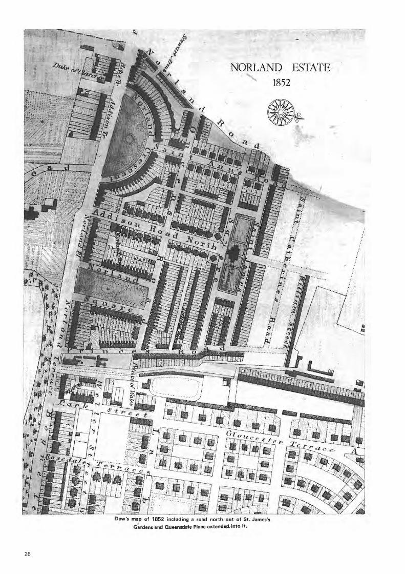
2.3.1 Robert Cantwell, Norland’s architect, designed an estate based on two principal roads, Addison Avenue running north-south and Queensdale Road running east-west across the estate. In the southwest angle of these he
planned a crescent broken in the middle by St. Anne’s Villas to allow unobstructed passage of the Counters Creek sewer. In the south-east quarter he placed Norland Square. In 1839 building buildings leases were taken by Charles Stewart (who took a total of 150 building leases) and who with Richardson’s brother and partners in a law practice was a major speculator in the estate. Stewart had difficulty finding tenants will-ing to live so far from London, a problem which plagued the early establishment of the estate, and his houses in Holland Park Avenue were not fully occupied until 1845 and those on the east side of Royal Crescent, on which he took build-ing leases in 1842, not until 1848. The western half of the crescent was not occupied until 1856. This restricted Richardson’s ability to raise loans on further building leases. To assist builders in further developing his estate Richardson tried all possible incentives to induce lettings on built properties, agreeing contracts for gas lighting in 1842, mains water in 1843 and promoting an act of Parliament vesting management responsibility for street cleaning, paving, lighting ‘and mainte-nance of Royal Crescent, Norland Square and St. James’ Square gardens in twelve resident commissioners levying a rate of three shillings in the pound on properties. In 1844 the greatest allurement, a church, was built on a site donated by Richardson and costing £4,941. It was conse-crated in July 1845 after difficulties in raising the funds for its completion.
2.3.2 Despite all his efforts the progress of the estate continued to be erratic through lack of funds.
2.3.3 In 1840-43 the sites of twenty two-storey
stucco fronted paired houses and a Public House were leased in the southern half of Addison Avenue. The houses were to the design of the tradesmen building them and sold well. In the northern half the ten pairs of houses were to one
design tentatively attributed to F.W. Strent and which departed from the traditional two rooms per floor London town house style, having a wider frontage, fewer floors and well propor-tioned rooms. Considerable delay resulted from the lessee of the West side being unable to keep up his mortgage payments and the leases having to be resold to tradesmen. As a result it was not occupied until 1848, the leases for the east side not being sold until 1850.
2.3.4 Progress in Norland Square was, like-wise, unstable: the leases of all 51 plots being granted by 1844 but 32 of these were to Richard-son’s joint speculators on the estate who shared his own over-extended financial position. The only multiple lessee who was a tradesman was declared bankrupt in 1845 resulting in houses on the west side not being occupied until 1849 and those on the north side (let to Richardson’s brother) and east side were unoccupied until 1852-53. The houses are typical London terraces
2.3
26

27
style with two rooms per floor on four floors over a basement.
2.3.5 Behind the houses on the north side of Norland Square two ranges of plain brick artisans cottages were leased in 1844-45. Now replaced, they had two storeys over basements and since they backed the Gardens of Norland Square and St. James’ Gardens, had no rear windows and were only 14 feet deep and 24 feet wide, set back on substantial gardens.
2.3.6 In 1843 Stewart had built two terraced ranges of five houses on four storeys in St.
Anne’s Villas to continue Cantwell’s Royal Cres-cent style. As with the Crescent itself he found difficulty in finding tenants and they were not occupied until 1848. He therefore experimented with a new style of semi-detached Tudor Gothic style of houses in a layout design of 1841, for which building leases were granted in 1845-46. Of 24 proposed paired houses north of Queens-dale Road only seven were built and six occu-pied by 1848 and Stewart assigned some of the leases to the other speculators. Building was resumed in 1850 but they were not fully occupied until 1859.
2.3.7 Other buildings of similar style were the stone faced pair set at an angle on the west cor-ner of Addison Avenue and St. James’ Gardens and the modest stucco-faced mews houses de-signed by William Carson, Richardson’s clerk of works, and built in 1844 in Queensdale Walk. In 1843 Richardson gained permission to lay sew-ers for a square to be formed around a church in St. James’ Square. Richardson’s mounting financial difficulties forced him to sell the freehold of a twelve acre brick field north of this planned square. William Morris paid £7,190 in 1844 for the site having previously leased a twenty-two acre area which had also included the site of St. James’ Square for £1000 per annum. In the same year St. James’ Church was built to de-signs by Lewis Vulliamy, and between 1847 and 1851 five ranges totalling 37 houses were built to designs by John Barnett in the square and financed by one of the five new building societ-ies investing in the estate. These houses were in pairs linked by recessed bays of one or two storeys. The frontages were eight feet wider than Norland Square or Royal Crescent and allowed a more spacious and better proportioned interior with up to four rooms per floor.
2.3.8 By 1848 Richardson became unable to stand the pressure of his personal liability in the estate. He had built sewers on the estate at his own expense and advanced money to the principle builders and lessees to keep develop-ment moving. Despite his best efforts lettings of

28
29
property were slow and he was unable to raise sufficient loans against the ground rents, being unsuccessful in attempting to borrow £120,000 in 1846. By 1849 he had sold at least 270 of the 500 freeholds on the estate and carried on selling piecemeal until 1852. This included all 37 houses and land of St. James’ Square as well as the vacant north side site, sold complete in 1852 and resold piecemeal mostly to shareholders of the original building society.
2.3.9 The building in St. James’ Square had stopped in 1851 with one of the projected ter-races not started on the north side. The builder of the majority of the houses became bankrupt and the works in progress were completed by a different builder but development did not restart on the northern site until the mid 1860’s. Virtually the rest of the estate was sold to an auctioneer Frederick Chinnock to pay off Richardson’s debts in 1852.
2.3.10 Aside from the north side of St. James’ Gardens and Penzance Street and Place and that area sold to Morris as a brick field, the estate was completed by early 1850s. In a dozen years over 500 houses had been built on a suburban estate but Richardson, the prime mover and financier was bankrupt by 1855.
2.3.11 When Morris developed his brick fields he abandoned the original plans to put three roads northward out of St. James’ Square and when building on the north side resumed in 1864 the site of the projected roads was built over leaving only Princedale and St. Anne’s Road as access
to his area. The conditions left by his brick field exploits led him to build an estate of modest dwellings crammed with as many terraces as possible on long straight streets. The character of development therefore changes north of the St. James’ Gardens and Darnley Terrace ranges, the line of the present conservation area bound-ary.
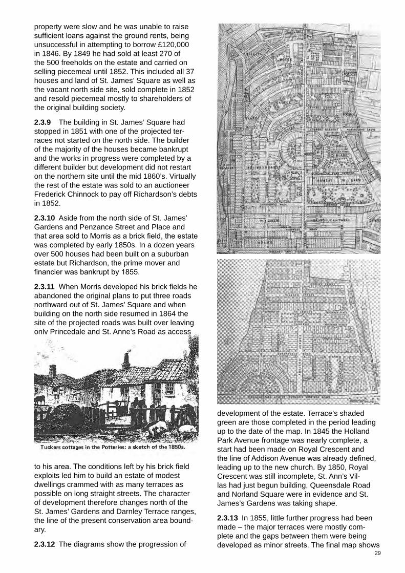
2.3.12 The diagrams show the progression of
development of the estate. Terrace’s shaded green are those completed in the period leading up to the date of the map. In 1845 the Holland Park Avenue frontage was nearly complete, a start had been made on Royal Crescent and the line of Addison Avenue was already defined, leading up to the new church. By 1850, Royal Crescent was still incomplete, St. Ann’s Vil-las had just begun building, Queensdale Road and Norland Square were in evidence and St. James’s Gardens was taking shape.
2.3.13 In 1855, little further progress had been made – the major terraces were mostly com-plete and the gaps between them were being developed as minor streets. The final map shows
30
the dates of the completion of the later terraces. Portland and Princedale Roads were built as part of the Lad-broke Estate, most of these terraces dating from the 1855-65 period.
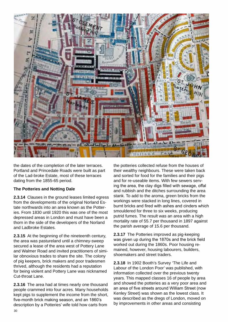
The Potteries and Notting Dale
2.3.14 Clauses in the ground leases limited egress from the developments of the original Norland Es-tate northwards into an area known as the Potter-ies. From 1830 until 1920 this was one of the most depressed areas in London and must have been a thorn in the side of the developers of the Norland and Ladbroke Estates.
2.3.15 At the beginning of the nineteenth century, the area was pastureland until a chimney-sweep secured a lease of the area west of Pottery Lane and Walmer Road and invited practitioners of simi-lar obnoxious trades to share the site. The colony of pig keepers, brick makers and poor tradesmen thrived, although the residents had a reputation for being violent and Pottery Lane was nicknamed Cut-throat Lane.
2.3.16 The area had at times nearly one thousand people crammed into four acres. Many households kept pigs to supplement the income from the short, five-month brick making season, and an 1860’s description by a Potteries’ wife told how carts from
the potteries collected refuse from the houses of their wealthy neighbours. These were taken back and sorted for food for the families and their pigs and for re-useable items. With few sewers serv-ing the area, the clay digs filled with sewage, offal and rubbish and the ditches surrounding the area stank. To add to the aroma, green bricks from the workings were stacked in long lines, covered in burnt bricks and fired with ashes and cinders which smouldered for three to six weeks, producing putrid fumes. The result was an area with a high mortality rate of 55.7 per thousand in 1897 against the parish average of 15.6 per thousand.
2.3.17 The Potteries improved as pig-keeping was given up during the 1870s and the brick field worked out during the 1860s. Poor housing re-mained, however, housing labourers, builders, shoemakers and street traders.
2.3.18 In 1902 Booth’s Survey ‘The Life and Labour of the London Poor’ was published, with information collected over the previous twenty years. This mapped classes 16 of people by area and showed the potteries as a very poor area and an area of five streets around William Street (now Kenley Street) was shown as the lowest class. It was described as the dregs of London, moved on by improvements in other areas and consisting

31
of many temporary residents. He called them an “unexampled concourse of the disreputable classes and as populated with criminals or near criminals which form the most serious mass of the kind of which we have to deal, greater than any now remaining in one spot in Central Lon-don”.
2.3.19 The builders of the modest properties in the area found from their completion that they were impossible to sell to respectable families. They became largely boarding houses over-crowded with the large transient population en-tering London. Employment followed similar lines to the potteries although many women took in the laundry of the west London middle class and a number of men were employed in the stables of the London Omnibus Company in Goreham Place, on the Central London Electric Railway or in the yards of the Great Western Railway.
2.3.20 In 1892 Adams brick field, which sepa-rated the two areas and included a stagnant pool known as ‘The Ocean’ was bought by Kensington Vestry. After some costly landscape works this was opened as Avondale Park as an amenity in this predominantly poor area. The Council also purchased some, of the poor properties in Not-ting Dale in the late nineteenth century, includ-ing William Street (Kenley Street) in an attempt to discourage overcrowding. A photo shows the backs of the properties just prior to purchase. This obviously did not alleviate the problem since Booth’s study of 1902 still regarded this area as of the worst kind.
2.3.21 At the time that Richardson was de-veloping the estate, the reputation of the pot-teries may have hindered the easy letting of completed properties. Early plans to extend the estate northwards from St. James’s Gardens might, therefore, have been doubtful even before Richardson sold the brickfield north of the area to Morris.
Portland Road
2.3.22 When originally laid out and developed, the eastern boundary of the Norland Estate was demarcated by the houses on the west side of Portland Road up to No 41, and the west side of Pottery Lane. Between this boundary and the Ladbroke Estate was a hinterland, undeveloped except for some stables on Pottery Lane. This hinterland was acquired in about the 1840-1850’s by the solicitor partner to the Ladbroke Estate developers, Mr Richard Roy. To the north west of that hinterland laid the “unmitigated squalor” of the Potteries, where, in the 1840’s, bricks and tiles were made for use in the erection of gentle-men’s residences being built eastwards further
up the Hill. Mr Roy on his own account com-menced speculative development of this hinter-land in the 1850s. By 1852, 85 Clarendon Road (a three-storey stucco-faced building standing at the junction of Clarendon Road with North Port-land Road – currently an old peoples’ home) had been developed as the Clarendon Hotel (until it became a house from 1919) and built by William Reynolds under a lease of 1846 from Richard Roy.
2.3.23 Most of the streets in this locality were named on a whim of the developer or builder concerned. For example, in 1937, Lansdowne Rise was known as Montpellier Road (Montpel-lier was a popular post-Napoleonic Wars street name). Within Mr Roy’s land, the part of Portland Road between 102-134 (east) and 141 - 179 (west) appears originally named “Montpellier Terrace” but, from about 1865, became known as “Portland Road” (together with the road to its south).
2.3.24 But, in about 1853, the wider area suf-fered a severe building recession, leaving many buildings as naked carcasses. These included the then incomplete buildings on Mr Roy’s land.
2.3.25 From about 1860 onwards, a building recovery occurred and this enabled development

32
of the wider area to be completed. Just as the Ladbroke Estate began to recover, and its prop-erty was finished “on the cheap and by a differ-ent architect”, unfinished houses were gradually completed and derelict spaces infilled, so too was Mr Roy’s development of Portland Road haphazardly completed. Unlike the Norland and Ladbroke Estates, it is impossible to say that his land was actually originally designed or mas-ter planned, or even to realize how it originally ought to have been developed. This haphazard completion is reflected in the disparate physical appearance of its particular stretches and (within each stretch) local variation within individual properties still observable today.
2.3.26 In 1886, Charles Booth socially surveyed parts of London including Portland Road and the survey shows a social consequence of the 1850-60s’ boom and slump was to divide Portland Road into 2 social parts: a) a southern part - up to today’s Clarendon Cross - defined as “poverty and comfort (mixed)”; b) a northern part, marked in blue, - defined as “moderate poverty” or “very poor”. This is based on Charles Booth’s map as shown on the previous page.
2.3.27 After World War II, the Council demol-ished the part of Portland Road north of Nos 136 and 179 for its new social housing (and that area was until recently subject to a regeneration or-der), demolished the large store building west of Nos 134 and 179, and was to demolish by order that between 102-134 (east) and 141-179 (west) until gentrification of that part slowly started from 1967.
2.3.28 Therefore, we attribute to Portland Road (north of 102 (east) and 141 (west) a reduced significance of appearance relative to the actual Norland Estate area; and within Portland Road, a graduated significance of character and appear-ance, where the area of Nos 102-134 (east) and 141 to 179 (west) has the least significance of the Norland Conservation Area. By contrast, the southern part of Portland Road has more signifi-cance, relative to the Conservation Area. This graduated approach means that a different vision and approach to the northern part of Portland Road (between Nos 102-134 (east) and 141 to 179 (west) is justified for its sustainable develop-ment.
2.3.29 Over time, a variety of Article 4 direc-tions have been implemented on Portland Road, covering different kinds of development. Most recently, the Council has rationalized the Article 4 directions covering the northern part - 102-134 (east) and 141 to 179 (west) so that paint-ing facades other than a pastel shade requires
planning permission, and painting brickwork is not permitted, whilst in the southern part Article 4 directions are more extensive, and within the actual Norland Estate more extensive still.
2.3.30 Although particularly relevant for listed buildings, this would be welcomed also for dou-ble glazed units in unlisted buildings in conserva-tion areas.