Embed Size (px)
Citation preview

Tectonics, Earthquakes, and Volcanism
Physical Geography Lecture - GEOG B1
Available on: www.cherylnail.com

Relief
• In Geography, "relief" refers to the highest and lowest elevation points - the vertical elevation differences on the surface.
• Topography is the general term for the undulations and other variations in the shape of Earth’s surface, including the relief.

*Geographers group the surface into three orders of relief. They classify landscapes by scale - continental to local.The first order of is the coarsest level of landforms - consisting of continents and oceans.**The second order looks at the intermediate level - like mountain masses, lowlands, plains.The third order looks locally - individual mountains, valleys hills, and other landforms.
Relief - The Big Picture *
Continental landmasses - the portions of the crust that reside above or near sea level, including the undersea continental shelves along the coastlines.
Ocean Basins - submarine portions of the crust - collectively cover ~71% of Earth’s surface and contain the overwhelming majority of all water on the planet **
*The average elevation of Earth’s total solid surface is actually under water: -2070 m (-6790 ft)Average elev for land: 875 m (2870 ft)Average elev for ocean’s depths: -3800 m (-12,740 ft)
Hypsometry
• Hypsometry is the measurement of land elevation and area relative to sea level.Fig. 13.2
• Bathymetry is the underwater equivalent.
• Elevations can take on either positive or negative (below sea level) values *

Topographic Regions
Earth’s landscapes can be generalized into six types:
• plains Fig. 13.3• high tablelands• hills and low tablelands• mountains• widely spaced mountains• depressions
5

Continental shield
Continental shield - a large region where a craton * is exposed at the surface - forms a tectonically stable area• Layers of younger sedimentary rock - called
continental platforms - surround these shields• Because of their stability, erosion has flattened
the topography of most of the continental shields; however, they commonly do have a very gently convex surface.
Fig. 13.4
*A craton is like the nucleus of a continent - it is made of ancient crystalline rock on which the continent grows by adding crustal fragments and sediments.Cratons are generally old and stable masses of continental crust that have been eroded to a low elevation and relief.
6

Crust Formation
Fig. 13.5 - Follow the process...
1. Crust formed at oceanic ridge
2. Eventually subducts below continent
3. Crust remelts, combining seawater, continental
sediment, & surrounding crust
4. Magma migrates upward - either become
subsurface intrusive bodies in crust, or reach
surface and become explosive volcanic eruptions
p. 362-363 - READ - especially about silica content
7

Accretion of Terranes
Each of the lithospheric plates are a collection of many crustal pieces.
• Slowly, migrating pieces of ocean floor, volcanic island arcs, and pieces of crust broken from other continents have been forced against the edges of continental shields and platforms.
• Terranes - crustal pieces that have become attached, or accreted, to other plates *
*Terranes have histories and compositionsdifferent from those of the continent that captured themThe suture zone between a terrane and the crust it attaches to is usually identifiable as a fault.Fig. 13.6 - North Am terranes - READ p. 363 (far right)
8
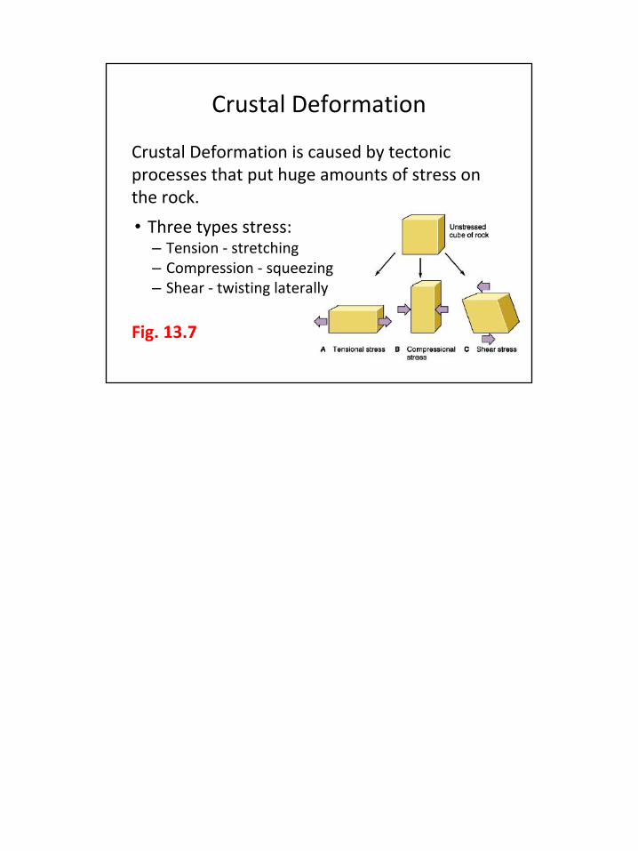
Crustal Deformation
Crustal Deformation is caused by tectonic processes that put huge amounts of stress on the rock.
• Three types stress:– Tension - stretching– Compression - squeezing– Shear - twisting laterally
Fig. 13.7

Types of Crustal Deformation
• Although stress is the force that works on rocks, the landforms that we see are a result of the strain - how rocks respond to the stress.
• Strain is expressed in the crust with either folding (bending) or faulting (breaking).

Folding
Folding - when rocks are deformed by compressional stress Fig. 13.8
• Anticlines - arch-shaped upward folds• Synclines - trough-shaped downward fold
– Remember the difference by noting that anticlines form an “A” shape, and synclines form the bottom of an “S.”

12

Folding - II
Over time, folded structures can erode to produce interesting land forms Fig. 13.9• Dome - an area of uplifted rock resembling ant
anticline that has been heavily eroded - leaving the oldest rocks exposed in the center of the dome (“bullseye”)
• Basin - an area of uplifted rock which resembles a syncline - oldest rocks exposed at the outside of the strata & youngest make up the basin
Folded mountains - Zagros “crush zone” - Fig. 13.10
13

*In this case we are specifically referring to tectonic stresses being placed on the crust**Under the LA region there are numerous thrust faults - caused the Northridge eq of 1994. Sadly many of the faults are called “blind thrust faults” because there is no surface evidence of ruptures - the faults are buried under the surface, but are still a major eq threat.
Faulting
Fault - a fracture/break in a volume of rock, caused when rocks on either side of the break shift in relation to the other side *• Normal fault - when the crust is pulled apart• Reverse fault - when crust is compressed & breaks -
hanging wall pushed up relative to footwall • Thrust Fault - reverse fault with a shallow angle - **
hanging wall overrides underlying footwall Fig 13.11 b
• Strike-Slip Fault - moves laterally (either left or right) - lateral shear with very little vertical motion Fig 13.12

15

Faulted Landscapes
• Horst - upward-faulted block of the Earth's crust that has lifted, or has remained stationary, while the land on either side has subsided.
• Graben - downward-faulted block of the Earth's crust bordered by parallel faults
Fig. 13.13
16

Examples: Basin & Range Province / East African Rift Valley / Lake Baikal in Siberia

Basin and Range Province
Basin and Range Province - a vast physiographic region that covers much of the inland Western United States and northwestern Mexico - defined by unique basin and range topography• Roughly parallel mountain
ranges and valleys are aligned pairs of normal faults
Fig. 13.14
18

Orogenesis
Orogenesis is mountain building.
Geosystems in Action - p.372-373
Fig. 13.15 / Fig. 13.16 / Fig. 13.17
Taking a picture walk
19

Earthquakes
Crustal plates do NOT slide smoothly past each other.
• The stress of plate motion builds strain and rocks deform until friction is overcome.
• The sides along plate boundaries or fault lines suddenly break loose.
Earthquake - the sharp release of energy that occurs at the moment of fracture - produces seismic waves *
*Remember - seismic waves are shock waves from where the rocks snap loose of each otherThe actual movement can be a few cm to several m
20

Types of Earthquakes
Tectonic earthquakes - quakes associated with faulting
Volcanic activity can trigger earthquakes. *
Induced seismicity - quakes triggered by the injection of wastewater from oil and gas drilling
*These quakes help volcanologists understand that there is magma movement underground
21

Earthquakes - Anatomy
Focus - the point where the seismic waves are generated by crust movement - this is the point from which the seismic waves move outward *
Epicenter - the spot directly above the focus **
Seismic waves and how they deform
* The energy released can be tremendous**Foreshocks & aftershocks - p. 375 READ
22

Measuring Earthquakes
Seismometer / seismograph - an instrument used to detect and measure the ground motion that occurs during an earthquake
Seismogram - the graphic plot of the motion
Earthquake magnitude is a measure of the energy release and provides a way to compare earthquake size.
p. 378-379 - Focus Study 13.1 - Comparing EQs
23

Earthquake Forecasting
Fig. 13.20 - Earthquake Hazard map for U.S.
Paleoseismology - the science that studies the history of plate boundaries and the frequency of past quake activity.
• Construct maps that estimate earthquake activity based on past performance
NOT even remotely accurate…. yet. *
*There are eq warning systems in place - a Mexico City system provides a 70 second notice of arriving seismic waves. March 2012 - people had time to get into safer spots before the shaking startedJapan has one too. They U.S. is working on it.
24

Volcanism
Start with Fig. 13.22 - tectonic settings of volcanic activity - along subduction zones, mid-ocean ridges, rift valleys, and hotspots
There are over 1300 volcanic cones, mountains, and calderas on Earth, but fewer than 600 are active.Active volcanoes are defined as having erupted at least once in recorded history.Eruptions in remote places and at depths on the seafloor go largely
unnoticed, but if it affects a population… Fig. 13.21READ - p. 382 about Eyjajfjallajokull
25

Volcano
Volcano - a structure on the surface containing an opening at the end of a central vent or pipe through which magma rises from the asthenosphere and upper mantle.
26

Volcanic Materials - I *
Pyroclastics - pulverized rock, ash, and clastic materials of various sizes ejected violently during an eruption
*Various materials pass through the central vent to the surface to build volcanic landforms, including lava, gases, and pyroclastics.
27

Volcanic Materials - II
The chemistry and gas content of lava decides its explosive force.
Basaltic lava - low in silica and water vapor - low viscosity - flows effusively *
• Aa - rough and jagged with sharp edges• Pahoehoe - shiney, smooth that resembles
coiled rope Fig. 13.23
Andesitic lava - high silica and water vapor content - high viscosity - explosive **
*Basalt - mostly flows at mid-ocean ridges, hot spots, and rift valleys** These volcanoes are usually the result of volcanic action over subduction zones.A volcano may erupt with different types of lava - again it depends on the chemistry and gas content.
28

Volcanic Landforms
• Crater - circular surface depression - usually found at or near the summit of a volcano.
• Cinder cone - small, cone-shaped hill made almost entirely of cinders and pyroclastic materials from a moderately explosive eruption. *
• Caldera - large, basin-shaped depression that forms when summit material on a volcanic mountain collapses inward after an eruption or other loss of magma **
*Cinder Cone - Fig. 13.24 / also near Mt. Shasta -- small meaning 450 km (1500 ft)
**Caldera - Fig. 13.25 - Long Valley Caldera - READ -- also Yellowstone
29

Effusive Eruptions
Effusive eruptions are outpourings of low-viscosity magma that produce enormous volumes of lava annually on the seafloor, and in places like Hawaii and Iceland. *• Flows directly from the asthenosphere and upper
mantle.
Shield volcano - built from effusive eruption - gently sloped Fig. 13.27 **
*Gases readily escapee from basaltic magma because of its low viscosity. Effusive eruptions pour out with little explosive activity - however sometimes a lava fountain will gush dramatically, powered by jets of rapidly expanding gases.** Kilauea eruption on Hawaii started in Jan. 1983 - longest eruption in recorded history. Has its own magma system extending down about 60 km (37 mi) -- Fig. 13.26
30

Flood Basalts
When a vent opening for an effusive eruption is more like an elongated crack, it is called a fissure.
Above hot spots and rift valleys, flood basalts can repeatedly erupt out of elongated fissures, forming extensive sheets of lava over the surface - sometimes many kilometers thick.
Flood basalts cover several large regions.
Fig. 13.28
31

Explosive Eruptions
Explosive eruptions - violent eruptions of magma, gas, and pyroclastics driven by the buildup of pressure in a magma conduit. *
• Produces much less lava than effusive eruptions, but it more than makes up for it with pyroclastics - ash, dust, cinders, scoria, pumice, and bombs.
• Pyroclastic flows - very dangerous
*Remember this is because the water-logged subducted plate melted and sent magma up through the continent, picking up silica and other materials that make the magma extremely viscous. It tends to clog the pipes.
32

33

Composite Volcanoes
Fig. 13.29
Composite volcano - large mountains produced by a series of explosive eruptions - has multiple layers of lava, ash, rock, and pyroclastics
• Tend to have steep sides and a distinct conical shape.
• If eruptions are all from the central vent, they have remarkable symmetry.
Mt. St. Helens - Fig. 13.31Mt. Pinatubo - p. 387 - READ
34