Embed Size (px)
Citation preview

This report is a document of the borrower. The views expressed herein do not necessarily represent those of ADB's Board of Directors, Management, or staff, and may be preliminary in nature. Your attention is directed to the “Term of Use” section of this website.
In preparing any country program or strategy, financing any project, or by making any designation of or reference to a particular territory or geographic area in this document, the Asian Development Bank does not intend to make any judgments as to the legal or other status of any territory or area.
Vol. 10: Environmental and Social Impact Assessment
Project Number: 49223-001 November 2017
GEO: Nenskra Hydropower Project
Prepared by SLR Consulting France SAS

Nenskra Hydropower Project
Supplementary Environmental & Social Studies
Volume 10
Cumulative Impact Assessment
DISCLOSURE AUTHORIZED
November 2017
Supplementary E&S Studies for the Nenskra HPP:
Volume 1
Non-Technical Summary
Volume 3
Social Impact Assessment
Volume 5
Hydrology & Water quality Impact assessment
Volume 4
Biodiversity Impact Assessment
Volume 2
Project Definition
Volume 8
Environmental & Social Management Plan
Volume 6
Natural Hazards and Dam Safety
Volume 7
Stakeholder Engagement Plan
Volume 9
Land Acquisition & Livelihood Restoration plan
Volume 10
Cumulative Impact Assessment

JSC Nenskra Hydro - Nenskra HPP – Cumulative Impact Assessment
DISCLOSURE AUTHORIZED - 901.8.9_ES Nenskra_Vol 10_Cumulative Impact Assessment_Nov 2017 page A
Issue and revision record
Revision Date Description Prepared by Checked by Approved by
1 21 February 2017 Authorized by JSCNH for public disclosure
N. Bukowski
N. Faulks
C. Repussard
D. Buffin
Taek Won Seo
2 16 November 2017 Revised version taking into account comments received during 2017 public disclosure period
N. Bukowski D. Buffin
Taek Won Seo
Disclaimer:
This report has been prepared by SLR Consulting with all reasonable skill, care and diligence, and taking account of the manpower and resources devoted to it by agreement with the party which commissioned it. Information reported herein is based on the interpretation of data collected and has been accepted in good faith as being accurate and valid.
This report is for the exclusive use of the party which commissioned it; no warranties or guarantees are expressed or should be inferred by any third parties. This report may not be relied upon by other parties without written consent from SLR. SLR disclaims any responsibility to the party which commissioned it and others in respect of any matters outside the agreed scope of the work.
This document contains confidential information and proprietary intellectual property. It should not be shown to other parties without consent from SLR and from the party which commissioned it.
SLR Consulting France SAS
155-157 Cours Berriat - 38000 Grenoble France
T: +33 4 76 70 93 41
www.slrconsulting.com

JSC Nenskra Hydro - Nenskra HPP – Cumulative Impact Assessment
DISCLOSURE AUTHORIZED - 901.8.9_ES Nenskra_Vol 10_Cumulative Impact Assessment_Nov 2017 page B
Contents
Preamble ........................................................................................................................................................ i Summary ....................................................................................................................................................... ii
1 Introduction ......................................................................................... 1
1.1 Project overview ......................................................................................................... 1 1.2 Need for CIA ................................................................................................................ 3 1.3 Objective of the assessment ....................................................................................... 3 1.4 Scope of the assessment ............................................................................................. 4 1.5 Methodology ............................................................................................................... 4 1.6 Sources of information ................................................................................................ 6 1.7 Structure of the report ................................................................................................ 7
2 Environmental and social context ........................................................ 8
2.1 Regional context .......................................................................................................... 8 2.2 Environmental conditions ........................................................................................... 9 2.3 Socioeconomic conditions .......................................................................................... 9 2.4 Hydropower developments ........................................................................................ 9 2.5 Transmission lines ..................................................................................................... 12
3 Scope for cumulative impact assessment ........................................... 17
3.1 Identification of VECs ................................................................................................ 17 3.2 VECs and their spatial and temporal boundaries ..................................................... 17 3.3 External activities ...................................................................................................... 22 3.4 Environmental stressors ............................................................................................ 23
4 Assessment of cumulative impacts .................................................... 25
4.1 River hydrology ......................................................................................................... 25 4.2 River geomorphology ................................................................................................ 32 4.3 Water quality ............................................................................................................. 37 4.4 Fish resources and fish habitat ................................................................................. 41 4.5 Terrestrial ecosystems and biodiversity ................................................................... 47 4.6 Socioeconomic impacts ............................................................................................. 52 4.7 Microclimate ............................................................................................................. 60 4.8 Reservoir triggered seismicity ................................................................................... 62
5 Synthesis of impacts, significance and commitments ................................ 65
JSC Nenskra Hydro - Nenskra HPP – Cumulative Impact Assessment
DISCLOSURE AUTHORIZED - 901.8.9_ES Nenskra_Vol 10_Cumulative Impact Assessment_Nov 2017 page C
Annexes
Annex 1 - References Annex 2 - Minutes of stakeholder consultations

JSC Nenskra Hydro - Nenskra HPP – Cumulative Impact Assessment
DISCLOSURE AUTHORIZED - 901.8.9_ES Nenskra_Vol 10_Cumulative Impact Assessment_Nov 2017 page D
Acronyms
% Percent
ADB Asian Development Bank
AIIB Asian Infrastructure Investment Bank
CIA Cumulative Impact Assessment
CPS Conservation Priority Species
CTGREF Centre Technique du Génie Rural des Eaux de des Forêts (Swiss Technical Centre for Rural Engineering, Water and Forests)
E&S Environmental & Social
EBRD European Bank for Reconstruction and Development
EPC Engineering-Procurement-Construction
ESIA Environmental & Social Impact Assessment
ESMP Environmental & Social Management Plan
GSE Georgian State Electrosystem
Ha Hectares
HPP Hydropower Project
ICOLD International Commission on Large Dams
IFC International Finance Cooperation
IFI International Financial Institutions
IUCN International Union for Conservation of Nature
KfW German Development Bank
km Kilometre
kV Kilovolt
LALRP Land Acquisition and Livelihood Restoration Plan
m asl Meters above sea level
Mm3 Million cubic metre
MoU Memorandum of Understanding
MW Megawatt
RTS Reservoir Triggered Seismicity
TL Transmission Line
UNFCCC United Nations Framework Convention on Climate Change
VEC Valued Environmental and Social Component

JSC Nenskra Hydro - Nenskra HPP – Cumulative Impact Assessment
DISCLOSURE AUTHORIZED - 901.8.9_ES Nenskra_Vol 10_Cumulative Impact Assessment_Nov 2017 page E
List of Tables
Table 1 – Hydropower projects and potential HPP sites within the Enguri watershed ............................. 10
Table 2 – High-level assessment of the E&S impacts of the TL project component - construction .......... 13
Table 3 – High-level assessment of the E&S impacts of the TL project component - operation ............... 16
Table 4 – Summary of cumulative impacts on hydrology .......................................................................... 31
Table 5 – Summary of cumulative impacts on river geomorphology ........................................................ 36
Table 6 – Summary of cumulative impacts on water quality ..................................................................... 40
Table 7 – Summary of cumulative impacts on fish resource and habitats ................................................ 45
Table 8 – Summary of cumulative impacts on terrestrial ecosystems and biodiversity ............................ 50
Table 9 - Summary of cumulative impacts and commitments ................................................................... 66
List of Figures
Figure 1 – Project location and main components .......................................................................................2
Figure 2 – Six-step approach for CIA .............................................................................................................4
Figure 3 – VEC-centres approach schematic .................................................................................................6
Figure 4 – Map of HPP projects and potential HPP sites within the Enguri watershed ............................. 11
Figure 5 – Cumulative impacts on hydrology – zones evaluated ............................................................... 27
Figure 6 – Schematic of VEC-centred CIA for hydrology ............................................................................ 28
Figure 7 – Schematic of VEC-centred CIA for geomorphology ................................................................... 33
Figure 8 – Schematic of VEC-centred CIA for water quality ....................................................................... 38
Figure 9 – Attenuation of the Khudoni reservoir and estimated overflow ................................................ 59
Figure 10 – Main fault segments in the project region .............................................................................. 64
JSC Nenskra Hydro - Nenskra HPP - Cumulative Impact Assessment
DISCLOSURE AUTHORIZED - 901.8.9_ES Nenskra_Vol 10_Cumulative Impact Assessment_Nov 2017 page i
Preamble
In August 2015, JSC Nenskra Hydro - the owner of the Nenskra Hydroelectric Power Project - submitted the Project’s final Environmental & Social Impact Assessment Report (ESIA) to the Government of Georgia as part of the national environmental permitting process. The ESIA report had been prepared by Gamma Consulting Limited - a Georgian consulting company - based on field investigations undertaken in 2011 and 2014 and following public consultations meetings held in May 2015.
Since then, several International Financial Institutions (the Lenders) have been approached to invest in the Project. The Lenders have recommended that a number of Supplementary Environmental and Social Studies be undertaken to supplement the existing ESIA report in order to ensure compliance with their environmental and social policies. In response to this requirement, SLR Consulting (SLR) has been engaged by JSC Nenskra Hydro to undertake a number of Supplementary Environmental and Social Studies.
This report is the final version of Volume 10 of the Supplementary Environmental and Social Studies. It details the findings of the Cumulative Impact Assessment of the proposed Project and is issued after the public disclosure period held from March-September 2017. It takes into account the comments received from the various stakeholders engaged with by the Project during the disclosure period. It must be read in conjunction with the other volumes of the Supplementary E&S Studies, which comprise the following:
• Volume 1: Non-Technical Summary
• Volume 2: Project Definition
• Volume 3: Social Impact Assessment
• Volume 4: Biodiversity Impact Assessment
• Volume 5: Hydrology and Water Quality Impact Assessment
• Volume 6: Natural Hazards and Dam Safety
• Volume 7: Stakeholder Engagement Plan
• Volume 8: Environmental & Social Management Plan
• Volume 9: Land Acquisition & Livelihood Restoration Plan
• Volume 10: Cumulative Impact Assessment (this report)

JSC Nenskra Hydro - Nenskra HPP - Cumulative Impact Assessment
DISCLOSURE AUTHORIZED - 901.8.9_ES Nenskra_Vol 10_Cumulative Impact Assessment_Nov 2017 page ii
Summary
This document is the Cumulative Impact Assessment (CIA) report, prepared as part of the Supplementary Environmental and Social (E&S) Studies for the Nenskra Hydropower Project (the Project).
Aim and purpose of the assessment
CIA is a requirement of the Lenders’ E&S policies. Furthermore, in the case of the Nenskra Project, CIA is of importance because of the potential cumulative impacts with other hydropower projects (HPPs) in the Enguri catchment basin.
The overall goal of the CIA is to identify environmental and social impacts and risks associated with the Nenskra Project that, in the context of existing, planned, and reasonable predictable developments, may generate cumulative impacts that could jeopardize the overall long-term environmental, social and economic sustainability of the Project and the Enguri watershed.
The CIA also includes a high-level assessment of the impacts from the Nenskra Project Transmission Line (TL), which will be designed, constructed and operated by Georgian State Electrosystem (GSE), who will also commission the performance of a dedicated ESIA for the TL.
The CIA is not to be confused with Strategic Environmental Assessment.
Approach and methodology
The approach used for the CIA follows the Good Practice Handbook on Cumulative Impact Assessment and Management for the Private Sector in Emerging Markets (IFC, 2013), which is consistent with the general approach recommended by the European Commission (Guidelines for the Assessment of Indirect and Cumulative Impacts as well as Impact Interactions, 1999). The assessment focuses on the environmental and social aspects of the receiving environment that are considered important for assessing risk and which are referred to collectively as “Valued Environmental and Social Components” (VECs).
VECs were identified with the participation of representative of the local communities, and to this end, a focus group discussion with key stakeholders took place on 5 April 2016. The main goal of the consultation was to inform stakeholders about the CIA process and facilitate their identification of key VECs. The Ministry of Energy was consulted in order to collect information regarding the status regarding other hydropower development in the Enguri watershed. The Ministry confirmed that the Khaishi HPP, Tobari HPP and Pari HPP – that appear on some documents in the public domain - are no longer on the list of potential projects. The official list of projects is provided in Table 1 in the main part of the report.
The existing, planned, and reasonable predictable developments, that could generate cumulative impacts with the Nenskra Project and which are addressed in this report comprise the following; (i) the Khudoni HPP, which is situated downstream from the Nenskra at the confluence of the Nenskra and Enguri Rivers; (ii) the existing Enguri reservoir, (iii) the various small run-of-river hydropower schemes that are planned in the Enguri watershed, and (iv) the Nenskra TL that will evacuate the power generated by the Project (and which is an associated facility. Also taken into consideration are the external activities – forestry, mining and tourism, and environmental stressors – including climate change and natural hazards.

JSC Nenskra Hydro - Nenskra HPP - Cumulative Impact Assessment
DISCLOSURE AUTHORIZED - 901.8.9_ES Nenskra_Vol 10_Cumulative Impact Assessment_Nov 2017 page iii
Cumulative impacts on river hydrology, geomorphology and water quality
The analysis has been broken down into the assessment of different reaches of the Nenskra,
Enguri and the Nakra Rivers, and which are impacted to different extents at different times by
either the Nenskra Project or the Khudoni HPP. However, the assessment has concluded there
is negligible “spatial overlap” of the impacts and no given reach is impacted significantly by
both the Nenskra and the Khudoni Projects.
Cumulative impacts on fish resources and fish habitat
The Nenskra project will cause a significant impact on fish and fish habitat by significantly
reducing flow in the 17-kilometre long reach between the dam and the powerhouse. The
Khudoni project will also have significant impacts on fish resources by the creation of an
artificial reservoir downstream of the Nenskra powerhouse. However, the 2 projects affect
different reaches of the Nenskra and Enguri rivers and there is no spatial overlap of impacts.
Consequently, it is expected that there will be no discernible cumulative impact on fish and
fish habitat from the Khudoni and Nenskra projects. Reduced flow in certain reaches of the
Nenskra River’s tributaries caused by small run-of-river schemes may represents a loss of fish
habitat even though ecological flows will be maintained and fish passes constructed at the run-
of-river weirs. Consequently, the fish in the Nenskra that also populate tributaries on the
Nenskra tributaries may be subject to cumulative impacts. However, with effective ecological
flows and use of fish passes, the residual impact is expected to be low and not significant. In
addition, a population of brown trout could develop in the Khudoni reservoir, and which may
at certain times of year move upstream and partially balance reduced fish numbers in the
Nenskra caused by the Nenskra Project. However, this positive impact will probably be
marginal.
In the Nakra valley, the reach of the Nakra upstream for the Nenskra Project’s diversion weir
will also be affected by 3 run-of-river hydropower schemes1 (Nakra HPP, Nakra 1 HPP and
Nakra 2 HPP). The weir constructed by the Nenskra Project will be equipped with a fish pass,
and it is expected that the upstream run-of-river HPPs will also be equipped with fish passes
and that suitable ecological flows will be maintained in the bypassed sections of the river.
Nevertheless, the combined effect of the Nenskra Project and the Nakra run-of-river schemes
is expected to cause a significant impact on fish population in the Nakra river.
Cumulative impacts on terrestrial ecosystems and biodiversity
No significant cumulative impacts are predicted on terrestrial ecosystems and biodiversity
because there is no spatial overlap of the affected areas of the different projects. On a
watershed scale, the overall loss of resources is not significant.
Cumulative impacts with regard to social licence to operate
At the time of writing, the Nenskra Project’s early works are ongoing, as are discussions with
affected people regarding compensation. Concerns about the Project have been raised by
stakeholders and some of the people from the Nenskra and Nakra valleys were not favourable
towards the Project in the early stages. This was partly a result of a perceived lack of social
license to operate on the part of the Project and hydropower developments in general.
However, the Project has engaged with local communities and revised the design of certain
facilities in order to avoid the need for physical displacement and minimise economical
1 Potential hydropower developments in the Nakra valley were previously disclosed as Nakra HPP. Since the disclosure
of the Nenskra Supplementary E&S studies in February 2017, the list of potential hydropower projects has been
updated by the Ministry of Energy. In October 2017, it included a new hydropower cascade planned to be located
upstream of the proposed water intake of the Nenskra Project: Nakra 1 and 2 HPPs.

JSC Nenskra Hydro - Nenskra HPP - Cumulative Impact Assessment
DISCLOSURE AUTHORIZED - 901.8.9_ES Nenskra_Vol 10_Cumulative Impact Assessment_Nov 2017 page iv
displacement. The Nenskra project is now seen in a more favourable light, and some members of the community express that they see the employment opportunities brought by the Project as positive. The Nenskra Project has the objective to set a standard with respect to the Good International Practice in terms of minimising social impacts, stakeholder engagement and public disclosure.
Cumulative impacts with regard to land acquisition
Most of the land needs for the Khudoni HPP, Nenskra HPP and the small run-of-river projects do not overlap spatially. However, the footprint of the Khudoni HPP labour camp may overlap with the Nenskra powerhouse work areas near Lakhami. However, this will depend on the final location of the Khudoni labour camp, which is still to be defined. There could be some similar cumulative land acquisition issues related to overlapping land requirements for the Nenskra TL in the area of the Nenskra powerhouse and the new substation in the Nenskra valley. However, at the time of writing the location of these components are not available and in addition, the Nenskra TL will be designed, constructed and operated by GSE, who will also manage the land acquisition for the TL.
Consequently, to mitigate the potential cumulative impacts, which could include cumulative impacts on pastures - the risk is clearly flagged in this CIA and publicly disclosed. The Nenskra Project sets the standard with respect to Good International Practice in terms of land acquisition, key information is publicly disclosed and any additional land acquisition will also be disclosed.
Cumulative impacts on employment
In the event that the construction works for the Nenskra and Khudoni projects are concurrent it is expected to result in a shorter overall period of work for local people - compared to the case that the two projects are realised one after the other. Also, in the case of concurrent construction, there may be a lack of local workers, and more workers from outside the region may be needed. Coordination between project developers and regional authorities are required in this respect. There will probably be a period with concurrent operation of both the Nenskra and Khudoni schemes. However, no discernible incremental increase in direct employment opportunities or negative impacts are expected as a result from the concurrent operations.
Cumulative impacts on economic activities
There are a number of now expired logging licenses in the western part of the lower Nenskra valley, but as these licenses have now expired, and no legal exploitation is expected. The recruitment of local people to work on the dam construction may result in a temporary decrease in local unauthorized logging activities because of the employment opportunities created by the hydropower Projects, and local sawmills may suffer from a drop in the supply of lumber.
There is a large mining license area encompassing the area around Mestia. However, this area does not overlap geographically with the Nenskra Project area of influence. In terms of timing, with the current Nenskra Project schedule, the Nenskra Project construction work should have been completed before any major works or recruitment related to the mining licence start and no cumulative impacts with mining in the area of Mestia are expected. An area in the Nenskra valley has been earmarked as “territories zoned for mining”. This could potentially be a source of pollution – from accidental spills and leaks of hazardous materials or possibly from heavy metal leaching due to acid rock drainage. However, as the nature of any mining and the timing of future development is unknown at the time of writing, the nature of potential pollution is unknown and this can only be flagged as a potential risk.

JSC Nenskra Hydro - Nenskra HPP - Cumulative Impact Assessment
DISCLOSURE AUTHORIZED - 901.8.9_ES Nenskra_Vol 10_Cumulative Impact Assessment_Nov 2017 page v
Areas around Mestia are developing tourist activities for both the summer and the winter months. However, the area of influence of the Nenskra Project does not geographically overlap with such tourist areas and no impacts related to land take are expected. However, incremental cumulative impacts caused by the Nenskra Project combined with other hydropower projects - especially the Khudoni project - could affect tourism. These impacts are related to (i) the use of the Jvari-Mestia road by construction traffic which could hinder tourists travel to Mestia, (ii) local recruitment for the hydropower Projects could represent competition for employment of local people, and (iii) the tourism industry could benefit from the presence of construction workers who may take advantage of tourist activities available and may bring their families and friends to the area for vacations.
Cumulative impacts with regard to public infrastructure, road noise, dust and road safety
If the construction works for the Nenskra and Khudoni projects are concurrent, it can be expected that the amount of traffic along the Jvari-Khaishi and Khaishi-Chuberi roads will be higher than if the projects were constructed at different times. This has implications on the size of the road needed, upgrading requirements and road maintenance. There are also issues around noise and dust in terms of public health and safety. The high level of traffic may cause traffic delays or give the road a bad safety reputation affecting tourist development around Mestia. The physical presence of the proposed Khudoni reservoir would require that a new section of the Jvari – Mestia road be constructed to replace the section flooded by the Khudoni reservoir. However, the route taken by the new section of the road has not yet been publicly disclosed. In the case that the Khudoni project construction starts before the Nenskra Project construction, the distance covered by Nenskra Project traffic may be slightly longer.
Cumulative impacts with regard to exposure to technological risk
The physical presence of the Nenskra dam and the TL will contribute to the general industrialisation of the valley and which translates as an increased exposure to technological risks. However, if exposure to risks is in alignment with European standards, although there may be an increase, the overall cumulative exposure shall probably be within acceptable and tolerable limits. The presence of the Nenskra dam could be perceived as an additional threat to the safety of the Khudoni dam and consequently downstream communities. However, the likelihood of failure of the Nenskra dam can expected to be in the same order of magnitude at that of the Khudoni dam – very remote likelihood - and the overall risk of the Khudoni dam failure with or without the presence of the Nenskra dam shall be within tolerable limits as both these dams will be constructed following the highest safety standards.
Cumulative impacts with regard to changes in microclimate
Discernible impacts on microclimate from the Nenskra reservoir could occur in the immediate area of the reservoir during the summer and which could comprise a slight cooling of the air around the reservoir and slightly increased humidity. However, because of the small size of the reservoir these changes are not expected to be detectable beyond Tita, which is 4 kilometres downstream from the dam. No discernible microclimate changes in winter are expected. For very large reservoirs in arid and semi-arid regions, microclimate changes in winter are a slight increase in air temperature around the reservoir. However, for the case of the Nenskra reservoir this is not expected because of the small size and harsh winters and high rate of recharge of the reservoir with cold water from the mountains. The microclimate changes around the Khudoni and Enguri reservoirs are not expected to rise up the valley to Chuberi – because the colder more humid air around the reservoir is denser than the ambient air and thus is not expected to move up a valley gaining 400 metres in altitude. Consequently, there is
JSC Nenskra Hydro - Nenskra HPP - Cumulative Impact Assessment
DISCLOSURE AUTHORIZED - 901.8.9_ES Nenskra_Vol 10_Cumulative Impact Assessment_Nov 2017 page vi
no spatial overlap of areas affected by change in microclimate from the Nenskra and Khudoni projects and therefore no cumulative impact.
Cumulative impacts with regard to reservoir triggered seismicity
The Project’s Earthquake Hazard Analysis concludes that there is general scientific consensus that reservoir triggered seismicity (RTS) occurs in areas where there is existing seismic activity and that the magnitude of RTS is not greater than that of the natural seismicity. The reservoir adds a small perturbation to the state of stress of faults and triggers fault displacement, thus causing a seismic event. It is general considered in the scientific community that such earthquakes would have occurred anyhow later, under the natural conditions of stress accumulation, and the presence of the reservoir only hastens the occurrence. When considering this, in the context of the Nenskra, Khudoni and Enguri reservoirs, it can be considered that the combined physical presence of the three reservoirs will therefore probably not cause a RTS event of greater magnitude than that of any one of the three reservoirs considered individually or the case without any of the dams. However, the additional stress that is put on the faults by the combination of the three reservoirs could increase the likelihood or frequency of RTS. There are a number of faults situated between the Nenskra and Khudoni reservoirs. The faults are at similar distances from both the Nenskra and Khudoni reservoirs, and could be influenced by both the reservoirs, and the possibility of occurrence of RTS cannot be excluded. As for the Nenskra reservoir alone, there are at present no feasible way to assess the maximum magnitude of RTS earthquakes, but events with a magnitude of 4.5 on the Richter Scale and possibly slightly more must be regarded as possible, which although they can be felt are not expected to cause damage to buildings.

JSC Nenskra Hydro - Nenskra HPP - Cumulative Impact Assessment
DISCLOSURE AUTHORIZED - 901.8.9_ES Nenskra_Vol 10_Cumulative Impact Assessment_Nov 2017 page 1
1 Introduction
This Cumulative Impact Assessment (CIA) is one of a set of 10 volumes that makeup the Supplementary Environmental and Social (E&S) Studies required by International Financial Institutions that are considering financing the Nenskra Project.
1.1 Project overview The proposed Nenskra Hydropower Project is a greenfield high head hydropower project with an installed capacity of 280 MW. The Project is located in the upper reaches of the Nenskra and Nakra valleys in the north-western part of Georgia in the Samegrelo-Zemo Svaneti.
The Project uses the available discharges from the Nenskra River and the adjacent Nakra River, developing a maximum available head of 725 metres down to the powerhouse located approx. 17 kilometres downstream the dam.
The main project components comprise a 1252 metre high, 870 metre long asphalt face rock fill dam on the upper Nenskra River creating a live storage of about 176 million cubic metres and a reservoir area at full supply level of 267 hectares. The Nakra River will be diverted into the Nenskra reservoir through a 12.2-kilometre transfer tunnel. The power waterway comprises a headrace tunnel of 15.1 kilometres length, a pressure shaft and underground penstock of 1,790 metres length. The aboveground powerhouse is located on the left side of the Nenskra River and will house three vertical Pelton turbines of 93 Megawatt (MW) capacity each, for a total installed capacity of 280 MW. A 220 kV transmission line that will be 1-5 kilometres in length will connect the Nenskra powerhouse to a projected new substation situated in the Nenskra valley.
The main construction period is planned to start in Q1/Q2 2018 and will last 4 years. Some early works have been executed, starting in October 2015 and are ongoing at the time of writing: rehabilitation of access roads and geotechnical studies. Power generation is planned to start in 2021, if the conditions are favourable. The Project is being developed by JSC Nenskra Hydro, whose main shareholders are K-water, a Korean government agency and Partnership Fund, an investment fund owned by the Government of Georgia. K-water and Partnership Fund are referred to as the Owners in this document.
The project location and layout of the Nenskra project components is illustrated on the map provided in Figure 1. The location of the Nenskra project in relation to other hydropower projects is provided in Figure 4 on page 11.
2 Dam height was previously disclosed as 130 m. Dam height is now referred to as 125 m as this relates to the height from the deepest point on the upstream face of the dam, whereas the 130 m previously quoted relates to the height from the deepest point on the downstream face of the dam. The reservoir full supply level and the design of the dam have not changed. This has been amended to provide consistency with other Project documents.

!
!
!
!
!
!
!
!
!
!
!
!
!
!
!
!
!
!
!
!
!
!
!
!
!
!
Dizi
Kari
Tita
Nakra
Anili
Lukhi
Devra
Kedani
Tobari
Nodashi
Khaishi
Lakhani
Latsomba
Kvitsani
Jorkvali
Letsperi
Sgurishi
Shtikhiri
Lenkvashi
Skordzeti
Lekalmakhi Kveda Ipari
Zeda Marghi
Kvemo Marghi
265000
265000
270000
270000
275000
275000
280000
280000
285000
285000
290000
290000
295000
295000
4760
000
4765
000
4770
000
4775
000
4780
000
N
WGS 84 UTM 38 N
0 1 2 30.5Km
Source:
L_6768-B-GE-GE-GE-DW-003_003
L_6768-B-GE-PH-GE-DW-001_001
L_6768-B-UW-HR-GE-DW-001_001
L_6768-B-UW-TT-GE-DW-001_001
File n°
901.6.2_ES Project_Location_Main_Compartments_V06Feb2017
Headrace Tunnel
Nenskra Dam and
Reservoir
Nenskra
Okrili
Tita
Devra
Darchi-Ormeleti
Nens
kra
Enguri Khum
preri
Kheira
Ipari
Laila
Nakra
Nenskra Dam
Service Layer Credits: Sources: Esri, HERE, DeLorme, Intermap, increment P Corp., GEBCO, USGS, FAO, NPS, NRCAN, GeoBase, IGN, Kadaster NL, Ordnance Survey, Esri Japan, METI, Esri China (Hong Kong),
swisstopo, MapmyIndia, © OpenStreetMap contributors, and the GIS User Community
February 2017DateScale
@ A31:90,000
Map n° 1 Project Location and Main Components
NENSKRA HYDROPOWER PROJECT
Supplementary Environmental & Social Studies
Volume 10 - Cumulative Impact Assessment
© This drawing and its content are the copyright of SLR Consulting France SAS and may not be reproduced or amended except by prior written permission.SLR Consulting France SAS accepts no liability for any amendments made by other persons.
Transfer Tunnel
Nakra Intake
Powerhouse
and Switchyard
JSC Nenskra Hydro - Nenskra HPP - Cumulative Impact Assessment
DISCLOSURE AUTHORIZED - 901.8.9_ES Nenskra_Vol 10_Cumulative Impact Assessment_Nov 2017 page 3
1.2 Need for CIA CIA is a requirement of Lenders’ E&S policies. Furthermore, in the case of the Nenskra Project, CIA is important because of the potential cumulative impacts with other hydropower projects in the Enguri catchment. The Enguri dam-reservoir which has a footprint of 1,350 hectares is situated downstream of the Nenskra Project. Another important hydropower scheme - the Khudoni HPP, which would occupy an area of 530 hectares - is planned upstream of the Enguri reservoir and downstream from the Nenskra HPP. The Khudoni HPP construction was started in the soviet time and stopped when Georgia became independent. The Government of Georgia intends to resume the construction of this scheme.
The timing of the construction of the Khudoni scheme could coincide with construction of the Nenskra scheme. Local communities have expressed concern regarding cumulative impacts of Nenskra – Khudoni – Enguri in terms of Reservoir Triggered Seismicity (RTS) and changes to microclimate. In addition, there are numerous small run-of-river hydropower schemes at different stages of development in the Enguri catchment including the Nenskra River and its’ tributaries. It is important to note that as part of the preparation of this CIA, the Ministry of Energy was consulted in order to establish the status of hydropower development in the Enguri catchment. The Ministry confirmed that the other proposed large dam-reservoirs Projects on the Enguri – Khaishi HPP, Tobari HPP and Pari HPP – that appear on some documents in the public domain - are no longer on the list of potential projects.
The CIA is not to be confused with Strategic Environmental Assessment.
1.3 Objective of the assessment The overall goal of the CIA is to identify environmental and social impacts and risks associated with the Project that, in the context of existing, planned, and reasonable predictable developments, may generate cumulative impacts that could jeopardize the overall long-term environmental, social and economic sustainability of the Project and the Enguri watershed. The CIA has the following objectives:
• Assess the potential impacts and risks of the Project over time, in the context of potential effects from other developments and natural environmental and social external drivers;
• Verify that the Project’s cumulative impacts and risks will not compromise the sustainability or viability of the social and natural environment;
• Mitigate potential cumulative impacts when applicable;
• Confirm that the Project’s value and feasibility are not limited by cumulative effects;
• Ensure that the concerns of affected communities about the cumulative impacts are identified, documented and addressed, and
• Manage potential reputation risks.
The CIA outcomes are as follows:
• Identification of all aspects of the social and natural environment potentially affected by the Project;
• Establishment - in consultation with stakeholders - the selected aspects of the social and natural environment that the assessment will focus on;
• Identification of all other existing and reasonably anticipated and/or planned and potentially induced developments;
• Identification of natural environmental and external social drivers that could contribute to cumulative impacts;

JSC Nenskra Hydro - Nenskra HPP - Cumulative Impact Assessment
DISCLOSURE AUTHORIZED - 901.8.9_ES Nenskra_Vol 10_Cumulative Impact Assessment_Nov 2017 page 4
• Assessment and/or estimation of the future condition of selected social and environmental components, as the result of the Project’s cumulative impacts combined with those of other developments and natural environmental and external social stressors;
• Evaluation of the future condition of social and environmental components relative to thresholds or to comparable benchmarks;
• Identification of cumulative impact avoidance and minimization measures, and
• Definition of monitoring and management of cumulative E&S risks.
1.4 Scope of the assessment The study assesses the cumulative impacts of the Nenskra HPP with past, present and probable future hydropower schemes in the Enguri catchment basin and covering a geographical zone that encompasses the Enguri catchment basin upstream of the Enguri dam.
The approach used follows the Good Practice Handbook on Cumulative Impact Assessment and Management for the Private Sector in Emerging Markets (IFC, 2013).
The components of the hydropower schemes that are included in the assessment comprise the hydraulic structures, roads, transmission lines and temporary facilities such as construction camps. Other anthropogenic activities that potentially contribute to cumulative impacts - such as forestry, quarrying and mining concessions - are included in the assessment, though not as individual projects but as anthropogenic stressors. All past, present, or reasonably foreseeable projects that could contribute to cumulative impacts have been taken into account in this assessment.
1.5 Methodology The assessment focuses on the environmental and social aspects of the receiving environment that are considered important for assessing risk and which are referred to collectively as “Valued Environmental and Social Components” (VECs). A six-step approach has been used for the assessment as illustrated in Figure 2 below.
Source: Good Practice Handbook on Cumulative Impact Assessment and Management for the Private Sector in Emerging Markets (IFC, 2013)
Figure 2 – Six-step approach for CIA
Determine spatial and temporal boundaries
Identify VECs in consultation with affected communities and stakeholders
Identify all developments and external natural and social stressors affecting the VECs
Determine present conditions of VECs
Assess cumulative impacts and evaluate their significance over VECs’ predicted future conditions
Design and implement (a) adequate strategies, plans, and procedures to manage cumulative impacts, (b) appropriate monitoring indictaors, and (c) effective supervision mechanisms
STEP
1ST
EP 2
STEP
3ST
EP 5
STEP
4ST
EP 6
An
alys
is o
f th
e ex
isti
ng
lega
l, in
stit
uti
on
al a
nd
go
vern
ance
fra
mew
ork
JSC Nenskra Hydro - Nenskra HPP - Cumulative Impact Assessment
DISCLOSURE AUTHORIZED - 901.8.9_ES Nenskra_Vol 10_Cumulative Impact Assessment_Nov 2017 page 5
Steps 1 and 2 - Scoping
The scoping steps 1 and 2 comprise the identification of the VECs to be studied in the assessment and determination of the spatial and temporal boundaries of each VEC. VECs were identified by the CIA team with the participation of affected communities and taking into account concerns regarding cumulative impacts expressed by the communities during the Project’s stakeholder engagement process.
A specific consultation meeting regarding selection of VECs for CIA was held on 5 April 2016 in Chuberi and to which were invited representatives of the communities in the direct area of influence. Although a large number of people were invited to the meeting, only a limited number chose to participate (the minutes of the meeting are provided in Annex 2). However, because the Project’s stakeholder engagement process (see Vol. 7 Stakeholder Engagement Plan) had already enabled communities to express concerns about cumulative impacts it was considered that there had been sufficient input from communities, especially as no new concerns were raised during the meeting held in April 2016. Nevertheless, the Project will include further consultation with communities regarding their concerns on cumulative impacts and to be undertaken before start of construction (see social license to operate in section 4.6.1).
Future hydropower development projects were identified from review of documents prepared by the Georgian Ministry of Energy and a meeting was organised with the ministry to validate the tentative list prepared by the CIA team.
External activities and natural and social stressors were identified by the CIA team through review of secondary data and from knowledge of the regional context gained through the preparation of the other Supplementary E&S Studies.
In addition, several discussions were held in Tbilisi with governmental, non-governmental and private organizations3 to collect and/or confirm information issued from documents review. In October 2017, JSCNH met with the Integrated Management Department - Head Water Division who is the “focal point” for River Basin Management for the agreement implementation to understand progress on creation of Basin Management Organizations for the Enguri river basin (see Vol. 8 ESMP for more information).
Step 3 - determination of the present condition of VECs
Baseline conditions of VECs were collected by the CIA team from (i) review of Nenskra ESIA baseline survey data and reported in the Nenskra ESIA (Gamma, 2015); (ii) additional field data collected during the Nenskra Supplementary E&S Studies, and (iii) secondary data available in the public domain for neighbouring projects.
Steps 4 and 5 – Assess cumulative impacts and evaluate significance
The assessment uses a VEC-centres approach as illustrated in Figure 3 below.
Cumulative impacts are quantified where possible in terms of a given VEC’s response and changes to its condition. For each VEC, pressure-receptor indicators are selected which are used as a metric to “measure” the changes in the state of the VEC.
The selected indicators are simple quantifiable or qualitative measures of the condition or dynamics of broader, more complex attributes of the ecosystem or watershed state. These indicators act as surrogates for the underlying ecological processes.
3 Includes the following meetings: Hydrolea Ltd (30 March 2016); Ministry of Environment (4 April 2016); Nacres HPP (4 April 2016); Transelectrica Ltd (4 April 2016); GSE (5 April 2016); Enguri Ltd (5 April 2016); KfW (5 April 2016); National Forestry Agency (5 April 2016)

JSC Nenskra Hydro - Nenskra HPP - Cumulative Impact Assessment
DISCLOSURE AUTHORIZED - 901.8.9_ES Nenskra_Vol 10_Cumulative Impact Assessment_Nov 2017 page 6
Step 6 - Preparation of a framework for the management of cumulative impacts
For the significant impacts identified in Step 5, recommended control and mitigation measures are identified and these are summaries in Section 5 of the report, which is a synthesis of cumulative impacts, significance, and the recommended control and mitigation measures. The links with the Environmental and Social Management Plan (ESMP) are indicated in the synthesis table.
Figure 3 – VEC-centres approach schematic
1.6 Sources of information The information used in this CIA comprises:
• Baseline information for the Nenskra Project collected during environmental and social surveys carried out in the context of the ESIA prepared by Gamma in 2015, and additional survey carried out by SLR in 2015 and 2016 in the context of the Supplementary E&S Studies, and
• All information regarding the environmental and social baseline situation and impacts of past, present and probable future hydropower projects is secondary data.
VEC
Other human activities not
subject to ESIA
Project 1
Indirect Impact
Project 2
Project 3
Natural environmental
drivers (stresses)
Proposed action’s impact on the VEC
Proposed action’s impact on the VEC
Other past present and future impacts
on the VEC
Other past present and future impacts
on the VEC
Cumulative impacts on the VEC
Cumulative impacts on the VEC

JSC Nenskra Hydro - Nenskra HPP - Cumulative Impact Assessment
DISCLOSURE AUTHORIZED - 901.8.9_ES Nenskra_Vol 10_Cumulative Impact Assessment_Nov 2017 page 7
1.7 Structure of the report The report is structured as follows:
• Section 1 - Introduction: provides project overview, objectives, methodology, study area, and sources of information.
• Section 2 - Environmental and social context: provides a description of the regional context, environmental and social conditions, description of other hydropower projects in the Enguri watershed, high level assessment of the impacts of the 220 and 110 kV Transmission Lines and an overview of the regulations and institutional context.
• Section 3 - Scope for cumulative impact assessment: Describes the scoping of spatial and temporal boundaries, identification of VECs, identification and characterisation of external developments and environmental and social stressors.
• Section 4 - Assessment of cumulative impacts: Provides a synopsis of the baseline status for each VEC assessed, and an assessment of the cumulative impacts and significance.
• Section 5 - Synthesis of impacts, significance and commitments: This section comprises a synthesis of cumulative impacts, significance, and the recommended control and mitigation measures in tabular format. Links with the Environmental and Social Management Plan (ESMP) are indicated in the synthesis table.

JSC Nenskra Hydro - Nenskra HPP - Cumulative Impact Assessment
DISCLOSURE AUTHORIZED - 901.8.9_ES Nenskra_Vol 10_Cumulative Impact Assessment_Nov 2017 page 8
2 Environmental and social context
2.1 Regional context
2.1.1 Introduction
The Nenskra Project is situated in the Samegrelo-Zemo Svaneti region in North West Georgia. The dam will be located in the Enguri River watershed. The Enguri River emerges from the high Caucasus and flows from the Racha area in a westerly direction to Khaishi and then South West to the Black Sea. The Enguri watershed covers an area of 4,062 square kilometres for a river length of 213 kilometres and can be divided into three main reaches: (i) Upper part: from Mestia to Lakhamula; (ii) Central part: from Lakhamula to Jvari; and (iii) Lower part: from Jvari to the Black Sea. The main features of these areas are described in the following paragraphs and the reaches are illustrated on the map provided in Figure 4 on page 11.
2.1.2 Upper catchment area
Upstream from the village of Lakhamula, the Enguri valley is oriented in a westerly direction and bordered to the north and south by mountain ranges reaching altitudes higher than 3,500 metres. These are the Greater Caucasus range in the north, culminating at 5,193 metres (Mount Shkhara) and the Svaneti range to the south, culminating at 4,008 metres (Mount Lajla Lekheli). Most of the area is at altitudes ranging from 1,000 - 3,500 metres, with steep slopes subject to high erosion process. Tributary valleys are generally oriented north-south, and are much smaller and narrower, with the exception of the Mestiachala valley, where Mestia is located.
2.1.3 Central catchment area
Downstream from the village of Lakhamula, the Enguri valley is orientated towards the south-west. The central valley - approximately 70 kilometres in length between Lakhamula and Jvari - is much narrower than the upper valley, with very steep slopes. The valley is delimited to the west by the Abkhazian range and to the east by the Svaneti range, and reaching altitudes ranging from between 2,000 - 3,000 metres. Tributary valleys are present on both sides of the Enguri, the most important being the Nenskra valley on the right bank upstream from Khaishi. Upstream from Khaishi (between Lakhamula and Tobari), the valley presents a narrow gorge section, of approximately 15 kilometres. A few enlarged and flat areas along the river allow for human occupation with settlements, some arable land and saw mills. Khaishi is the main human settlement in the area. Downstream from Khaishi, the valley bottom is occupied by the 20 kilometres long Enguri Reservoir.
2.1.4 Lower catchment
Downstream from Jvari, the Enguri River flows out of the mountainous area, flows across a hilly landscape (with altitudes in the range of 200 to 500 metres) leaves the regional capital of Zugdidi on the left bank, and flows across the Kolkhida coastal plain to Anaklia on the coast. Downstream from Zugdidi, the river forms the administrative boundary between Georgia and the Russian occupied region of Abkhazia.

JSC Nenskra Hydro - Nenskra HPP - Cumulative Impact Assessment
DISCLOSURE AUTHORIZED - 901.8.9_ES Nenskra_Vol 10_Cumulative Impact Assessment_Nov 2017 page 9
2.2 Environmental conditions Annual precipitation is in the range of 1,250 to 1,350 millimetres in the Khaishi area and in the range of 900 to 1,000 millimetres in Mestia area. Average annual temperature is 10 to 12 degrees Celsius in Khaishi area and 5 to 7 degrees Celsius in Mestia area. Annual average temperature of the coldest month (January) is minus 0.1 degrees Celsius in Khaishi and minus 6 degrees Celsius in Mestia. Average temperature of the warmest month is 21 degrees Celsius in Khaishi (August) and 16.4 degrees Celsius in Mestia (July).
Forests, composed of dark coniferous forests, dominate the vegetated-landscape of the region. The upper limit of forests is at an altitude in the range of 2,000 to 2,400 metres. Evergreen undergrowth is represented by Cherry Laurel, Rhododendron and Holly. Cherry Laurel can be widespread in some valleys. A range of mixed deciduous forest dominates the lower zones. Especially notable are Georgian oak forests along the Enguri River. Above the limit of forest lies the sub-alpine zone, which is characterised by low growing ‘elfin’ forests of spruce, pine, fir and beech in dryer areas and by birch, beech and rowan in more moist areas. These areas can be floristically rich with regionally endemic birch species as well as the Pontic oak. The alpine zone is present above the sub-alpine zone (between about 2,500 and 3,000 metres). It is characterised by the dominance of short grass alpine meadows, which are used (where accessible) for grazing livestock in the summer months. Above the alpine zone is the sub-nival zone, where conditions are extreme, more than 300 plant species occur, mostly associated with rock and talus substrates. Above this, rocky peaks with glaciers are present. In the region, there are up to 55 mammal species, 152 bird species, 7 reptile species and 3 amphibian species and 35 fish species. The most emblematic species that occur in the area are the brown bear, lynx, wolf, West and East Caucasian Tur, falcons, eagles and hawks.
2.3 Socioeconomic conditions The population in the upper Svaneti area is mainly rural. The main city in the upper Enguri area is Mestia, with a population of 9,300 inhabitants in 2012 and the municipality of Mestia had 14,500 inhabitants in 2012. Main economic activities are farming (fruits, vegetables, corn and potatoes), cattle breeding, milk products making, beekeeping and logging. Beekeeping is very popular in Svaneti area. People do not fish on a commercial basis. Hunting is not authorised, though it does occur.
Upper Svaneti is well known for tourism, and especially for the famous Svanetian towers erected during the 9th to 12th Centuries. During the period 2008 - 2010 approximately 20 projects in the tourism sector were implemented in the Mestia municipality including construction of hotels and cafes, the development of internet service, establishment of the Mestia rural-agricultural market and road improvements.
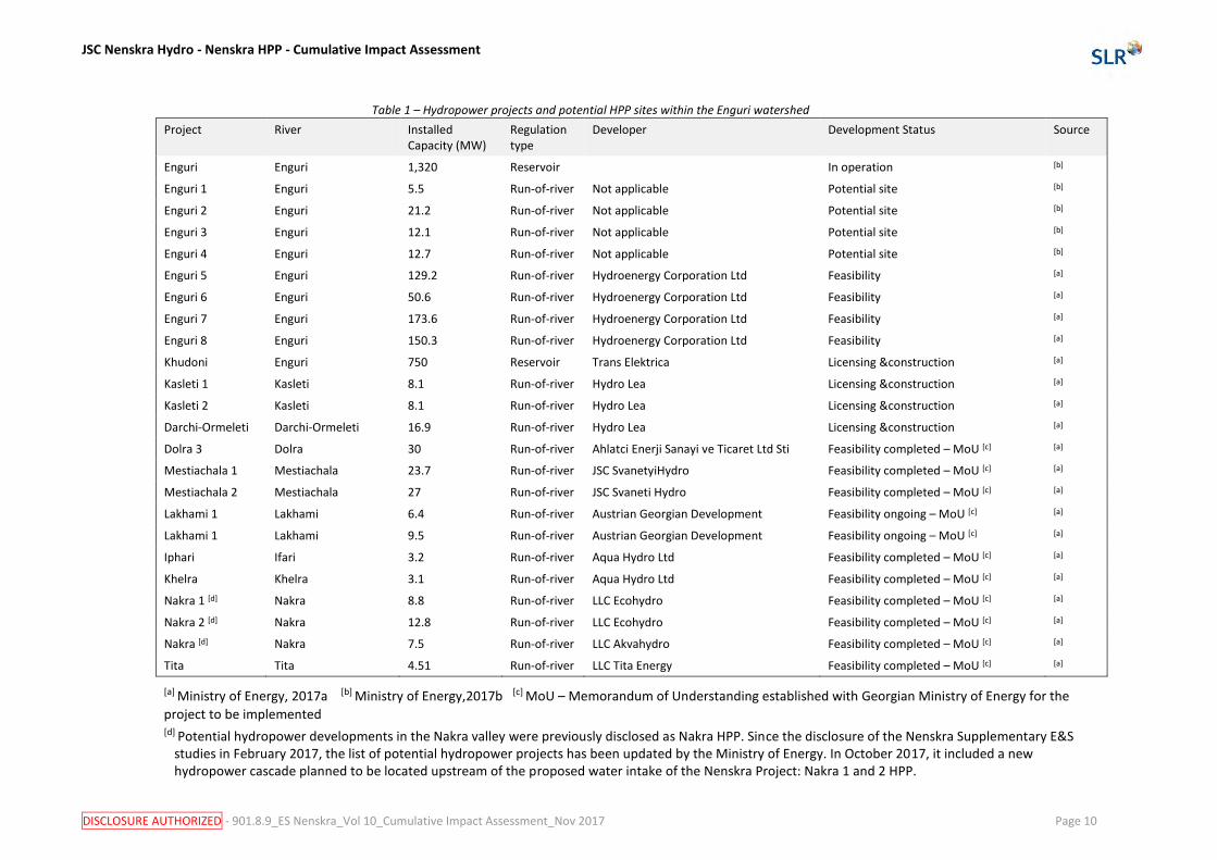
2.4 Hydropower developments Georgia, and in particular Samegrelo-Zemo Svaneti region, has important hydro-energy resources. In 2012, 60.8 percent of total produced electricity came from hydroelectric plants (World Fact Book, 2016). Several HPPs are planned or under construction, implementing the Cascade master plan on the Enguri River. The map provided in Figure 4 shows HPPs locations within the Enguri dam watershed and the projects are listed in Table 1.
JSC Nenskra Hydro - Nenskra HPP - Cumulative Impact Assessment
DISCLOSURE AUTHORIZED - 901.8.9_ES Nenskra_Vol 10_Cumulative Impact Assessment_Nov 2017 Page 10
Table 1 – Hydropower projects and potential HPP sites within the Enguri watershed
Project River Installed Capacity (MW)
Regulation type
Developer Development Status Source
Enguri Enguri 1,320 Reservoir In operation [b]
Enguri 1 Enguri 5.5 Run-of-river Not applicable Potential site [b]
Enguri 2 Enguri 21.2 Run-of-river Not applicable Potential site [b]
Enguri 3 Enguri 12.1 Run-of-river Not applicable Potential site [b]
Enguri 4 Enguri 12.7 Run-of-river Not applicable Potential site [b]
Enguri 5 Enguri 129.2 Run-of-river Hydroenergy Corporation Ltd Feasibility [a]
Enguri 6 Enguri 50.6 Run-of-river Hydroenergy Corporation Ltd Feasibility [a]
Enguri 7 Enguri 173.6 Run-of-river Hydroenergy Corporation Ltd Feasibility [a]
Enguri 8 Enguri 150.3 Run-of-river Hydroenergy Corporation Ltd Feasibility [a]
Khudoni Enguri 750 Reservoir Trans Elektrica Licensing &construction [a]
Kasleti 1 Kasleti 8.1 Run-of-river Hydro Lea Licensing &construction [a]
Kasleti 2 Kasleti 8.1 Run-of-river Hydro Lea Licensing &construction [a]
Darchi-Ormeleti Darchi-Ormeleti 16.9 Run-of-river Hydro Lea Licensing &construction [a]
Dolra 3 Dolra 30 Run-of-river Ahlatci Enerji Sanayi ve Ticaret Ltd Sti Feasibility completed – MoU [c] [a]
Mestiachala 1 Mestiachala 23.7 Run-of-river JSC SvanetyiHydro Feasibility completed – MoU [c] [a]
Mestiachala 2 Mestiachala 27 Run-of-river JSC Svaneti Hydro Feasibility completed – MoU [c] [a]
Lakhami 1 Lakhami 6.4 Run-of-river Austrian Georgian Development Feasibility ongoing – MoU [c] [a]
Lakhami 1 Lakhami 9.5 Run-of-river Austrian Georgian Development Feasibility ongoing – MoU [c] [a]
Iphari Ifari 3.2 Run-of-river Aqua Hydro Ltd Feasibility completed – MoU [c] [a]
Khelra Khelra 3.1 Run-of-river Aqua Hydro Ltd Feasibility completed – MoU [c] [a]
Nakra 1 [d] Nakra 8.8 Run-of-river LLC Ecohydro Feasibility completed – MoU [c] [a]
Nakra 2 [d] Nakra 12.8 Run-of-river LLC Ecohydro Feasibility completed – MoU [c] [a]
Nakra [d] Nakra 7.5 Run-of-river LLC Akvahydro Feasibility completed – MoU [c] [a]
Tita Tita 4.51 Run-of-river LLC Tita Energy Feasibility completed – MoU [c] [a]
[a] Ministry of Energy, 2017a [b] Ministry of Energy,2017b [c] MoU – Memorandum of Understanding established with Georgian Ministry of Energy for the
project to be implemented [d] Potential hydropower developments in the Nakra valley were previously disclosed as Nakra HPP. Since the disclosure of the Nenskra Supplementary E&S
studies in February 2017, the list of potential hydropower projects has been updated by the Ministry of Energy. In October 2017, it included a new hydropower cascade planned to be located upstream of the proposed water intake of the Nenskra Project: Nakra 1 and 2 HPP.

JSC Nenskra Hydro - Nenskra HPP - Cumulative Impact Assessment
DISCLOSURE AUTHORIZED - 901.8.9_ES Nenskra_Vol 10_Cumulative Impact Assessment_Nov 2017 Page 11
Figure 4 – Map of HPP projects and potential HPP sites within the Enguri watershed
JSC Nenskra Hydro - Nenskra HPP – Cumulative Impact Assessment
DISCLOSURE AUTHORIZED - 901.8.9_ES Nenskra_Vol 10_Cumulative Impact Assessment_Nov 2017 Page 12
2.5 Transmission lines
2.5.1 Description of the transmission lines required by the Project
Power evacuation transmission line (220 kV)
The power generated by the Nenskra hydropower scheme will feed into the national grid network, and to this end it will be conveyed from the Nenskra powerhouse to a tie-in point at a future 500/220/110 kV substation by a 220 kV Transmission Line (TL).
The TL will be designed, constructed and operated by Georgian State Electrosystem (GSE), who will also commission the performance of a dedicated ESIA for the TL. ESIA is required by Georgian law when the voltage is greater than 35 kV.
GSE is currently performing studies to select the location of the substation. However, it is expected to be in the Nenskra Valley close to the existing 500 kV Kavkasioni line (and not a location at Khudoni as previously disclosed in February 2017). In this case the TL will be between 1.5 and 5 kilometres in length.
Power supply line for construction (35 or 110 kV)
During the construction phase of the Nenskra project, a power supply will be required (see Vol. 2 Project Definition (Section 3.7.7)) and which will connect to the Nenskra powerhouse.
A number of options for the power supply continue to be investigated by the Project, each of which involves some form of new powerline, either 35 kV or 110 kV, and with the alignment along the Nenskra Valley from a tie-in point in the Enguri valley. The powerline will be designed, constructed and operated during construction by the EPC Contractor. The powerhouse will initially be powered by diesel-generators until the supply line is operational.
At the time of writing, an alternatives analysis for the power supply line was ongoing. As per the ESMP provisions (see Vol. 8, section 5.12), the selected option will be subject to a Health, Safety, Environmental & Social assessment with associated mitigation measures, environmental and social management plans including an addendum to the Land Acquisition & Livelihood Restoration plan. An EIA will also have to be prepared and provided to Georgian authorities.
Other power supply lines (35 kV)
In addition to the main power supply to the Nenskra powerhouse, a 35 kV powerline would extend from the powerhouse to the dam site to provide energy for construction and operation. The dam site will initially be powered by diesel-generators until the supply line is operational. A 35 kV powerline will extend from the powerhouse for the construction of the penstock surge shaft. The alignments of these 2 powerlines is currently being studies by the Project.
2.5.1.2 Description of the associated transmission lines to export power from the project and other projects
The main direction of development of Georgian transmission grid is to reinforce the 500 kV transmission grid from West (where are located the existing and future hydropower projects) to East and South (Consumption and Export), to integrate to the grid the new hydropower projects and to reinforce the cross-border transmission network.

JSC Nenskra Hydro - Nenskra HPP – Cumulative Impact Assessment
DISCLOSURE AUTHORIZED - 901.8.9_ES Nenskra_Vol 10_Cumulative Impact Assessment_Nov 2017 Page 13
In order to optimize the load flows, increase the transfer capacity, improve the security of supply of the grid, and be able to connect the new hydropower plants to be constructed, GSE has developed a 10 Year Network Development Plan for Georgia. As part of this plan, GSE will develop and implement the Open Program Extension Transmission Network Georgia (Phase 2). In the Enguri watershed, to export the power generated by the Nenskra HPP Project and other proposed hydropower projects in the Enguri Valley catchment, the Program comprises the following components:
• Construction of 500 kV single-circuit overhead transmission line from Jvari to the future 500/220/110 kV GIS substation in the Nenskra Valley (approx. 45 km long).
• Construction 220 KV double-circuit overhead transmission line from the new 500/220/110 kV GIS substation in the Nenskra Valley to Mestia operated first at 110 kV (approx. 90 km long).
• 500 kV overhead transmission line Kavkasioni tie-in to new 500/220/110 kV GIS substation in the Nenskra Valley (approx. 1 km).
This is the responsibility of GSE and a study is underway to examine the existing capacities, the need for new connections and the location and routes of new infrastructure.
2.5.2 High-level assessment of impacts of the Nenskra Project transmission lines
Taking into account the lack of information regarding the alignments of the Project’s TL power lines, a high-level assessment is provided in this CIA. The assessment is provided in Table 2 below and applies equally to the power evacuation line, construction power supply line and other power supply lines.
The assessment of the cumulative impacts of transmission lines—including TLs to be developed by GSE in the frame of the 10 Year Network Development Plan for Georgia—is provided in section 4. Cumulative impacts are expected to be in relation to forest resources (section 4.5.1 ), avian species (section 4.5.3) land acquisition (section 4.6.2 ) employment (4.6.3) and public infrastructure (section 4.6.4).
Table 2 – High-level assessment of the E&S impacts of the TL project component - construction
Affected VEC Impact producing factor
Nature, magnitude and significance of impact
Control and mitigation measures
Residual impact significance
1. Soils, geology and morphology
Construction of concrete platforms which are the bases for the TL/power line towers.
Towers are expected to be erected every 300 m along the alignment.
Each tower can be expected to occupy an area of 50 m2. However, it is not possible to estimate the number of towers.
During construction, each platform location will need to be accessed either by vehicle (or possibly helicopter) and there may be a need to create some temporary access tracks if the transmission line does not follow a new or existing road
Minor Significance
TL route to follow existing track or new track/road if possible
Length of temporary tracks to access platform sites are to be minimised
Waste management plan to be developed and implemented
Negligible - Minor Significance

JSC Nenskra Hydro - Nenskra HPP – Cumulative Impact Assessment
DISCLOSURE AUTHORIZED - 901.8.9_ES Nenskra_Vol 10_Cumulative Impact Assessment_Nov 2017 Page 14
Table 2 – High-level assessment of the E&S impacts of the TL project component - construction
Affected VEC Impact producing factor
Nature, magnitude and significance of impact
Control and mitigation measures
Residual impact significance
2. Water resources Runoff with high sediment content from areas cleared of vegetation (platform construction and tracks) runs into surface water
The cleared areas are negligible in size compared to the catchment. Impact of negligible significance
Runoff management measures implemented at platform construction sites
Negligible Significance
Accidental pollution from spills and leaks
Significance depends on size of spill. For the TL construction hazardous material will be mainly fuel. Largest spill probably no more than 100 litres.
Minor to moderate significance
Spill prevent plans developed and implemented
Clean-up of any spills
Negligible Significance
3. Flora Clearing of vegetation of a height greater than 1.5 m along the 30 m wide wayleave
Clearing of vegetation at the platforms
Magnitude and significance will depend on selected alignment and species present. Impact could be in the range of negligible to moderate significance
Pre-construction botanic survey to be carried out
TL route and position of platforms to be adapted as possible to avoid destroying Conservation Priority Species (CPS)
Transplant when feasible individual CPS that would otherwise be destroyed by the construction work
Negligible – minor significance
4. Wildlife Clearing of vegetation will represent a loss of habitat for fauna and the construction work will cause a physical disturbance
Mobile fauna will flee the immediate area during construction work
Impact could be in the range of negligible to moderate significance
Pre-construction survey to be carried out identify the presence of any rare or vulnerable wildlife – including birds and nesting
Negligible – minor significance

JSC Nenskra Hydro - Nenskra HPP – Cumulative Impact Assessment
DISCLOSURE AUTHORIZED - 901.8.9_ES Nenskra_Vol 10_Cumulative Impact Assessment_Nov 2017 Page 15
Table 2 – High-level assessment of the E&S impacts of the TL project component - construction
Affected VEC Impact producing factor
Nature, magnitude and significance of impact
Control and mitigation measures
Residual impact significance
5. Social environment
Land acquisition Depending on alignment of TL and type of land use impacts could include:
Temporary loss of pasture land or access to pasture land
Loss of homes and need for resettlement
Impact on public infrastructure
negligible to high significance
Identify land owners and land tenure
Engage with stakeholders for acquisition or leasing of land
Minimise land acquisition
Adapt TL route to avoid impacting pasture land or access to pasture land
Adapt TL route to avoid encroaching on private houses or gardens
Entitlements Matrix will follow international requirements, thus ensuring that both formal and informal land use and ownership will be equally acknowledged
Negligible – minor significance
Road use generating noise, dust and representing an increased risk of road accident
Construction traffic will contribute a small amount to the general high level of traffic on the road Jvari-Kaishi and Kaishi-Chuberi roads
Negligible – minor significance
Traffic management plans
Negligible – minor significance
Exposure to risk of unstable slopes
Depending on the selected TL alignment tower platforms may need to be constructed on steep and unstable slopes. The construction work may cause rockfall onto public roads or areas where general public may be present
Impact could be in the range of negligible to high significance
Risk assessment, including natural hazards
Adapt TL alignment to avoid areas of unstable slopes, especially where construction work could result in rockfall affecting communities or infrastructure
Negligible – minor significance

JSC Nenskra Hydro - Nenskra HPP – Cumulative Impact Assessment
DISCLOSURE AUTHORIZED - 901.8.9_ES Nenskra_Vol 10_Cumulative Impact Assessment_Nov 2017 Page 16
Table 3 – High-level assessment of the E&S impacts of the TL project component - operation
Affected VEC Impact producing factor
Nature, magnitude and significance of impact
Control and mitigation measures
Residual impact significance
1. Community health and safety
Electromagnetic radiation
Depending on the alignment of the TL with respect to homes and residential areas, public may be exposed to levels of electromagnetic radiation above EU standards, which would be of moderate to high significance
TL alignment to avoid homes and residential areas
Safety distance between TL and any home
Design of TL in compliance with European Industry Standards
Negligible significance
High voltage cables Depending on the alignment of the TL public may be exposed to risk of electrocution in the case of structural failure of the TL due to natural hazards or extreme weather. moderate to high significance
TL alignment to avoid homes and residential areas
Safety distance between TL and any home
Design of TL in compliance with European Industry Standards
Negligible significance
2. Avifauna Physical presence of high voltage power lines
TL can attract avifauna and cause mortality and large bodied / heavy birds may strike the TL that are strung across valleys through which they fly
TL to be equipped with devices to prevent bird kill
Negligible significance
3. Visual amenity Physical presence of high voltage power lines
Depending on the route of the TL public may be particular visible and may deteriorate the landscape in a valley which has high tourist potential.
Minor to moderate to significance
TL route selection criteria to include visual impact – and it is to be endeavoured to avoid having the powerline crossing the valley in a highly visible manner
Negligible to minor significance

JSC Nenskra Hydro - Nenskra HPP – Cumulative Impact Assessment
DISCLOSURE AUTHORIZED - 901.8.9_ES Nenskra_Vol 10_Cumulative Impact Assessment_Nov 2017 Page 17
3 Scope for cumulative impact assessment
This section presents the first steps of the CIA, which comprised defining spatial and temporal boundaries, identifying the VECs that are located within those boundaries, identifying neighbouring past, present and probable future developments that could contribute to cumulative impacts on VECs and characterising external activities and environmental and social stressors.
3.1 Identification of VECs The identification of the VECs - which are the focus of this CIA - was undertaken as follows:
• Consultations with local stakeholders and communities: The Project Company and SLR conducted a series of Focus Discussion Groups (FDG) with key stakeholders on 5 April 2016 (see Annex 2). The main goal of these consultations was to inform stakeholders about the CIA process and facilitate their identification of key VECs.
• Documentation of information regarding the Project works and activities and the environment likely to be affected, as captured in the original ESIA (Gamma, 2015) and the Supplementary E&S Studies.
• Expert judgment based on the CIA team’s experience with ESIAs for hydropower projects.
The selected VECs, the rationale for their selection, and their spatial and temporal boundaries are described in Section 3.2 below.
3.2 Spatial and temporal boundaries of VECs VECs and their spatial and temporal boundaries are described on the following pages Each subsection describes the VEC and the boundaries of the area considered for the CIA. The list of VEC and a summary of their special and temporal boundaries are presented in Table 4 overleaf. The assessment of cumulative impacts (section 4) also provides additional information on spatial and temporal boundaries of each VEC studies as appropriate.
3.2.1 River hydrology
The river hydrology is addressed as three separate VECs, which are (i) Nenskra River hydrology, (ii) upstream Enguri hydrology and (iii) downstream Enguri hydrology. The 3 sections of rivers are addressed separately as the magnitude of impacts from the Nenskra Project differ for each section, and not all neighbouring future projects impact all three sections.
Nenskra River hydrology
River flow rate is selected as a VEC because the Nenskra River is the habitat of Brown Trout – which are a protected species in Georgia and flow rate influences sediment transport, which effects fish habitat. The direct area of influence of the Nenskra Project encompasses the Nenskra River - from the confluence with the Okrili tributary and extending to the confluence with the Enguri, which represents a length of 17 kilometres of river. Impacts on river flows are

JSC Nenskra Hydro - Nenskra HPP – Cumulative Impact Assessment
DISCLOSURE AUTHORIZED - 901.8.9_ES Nenskra_Vol 10_Cumulative Impact Assessment_Nov 2017 Page 18
expected to occur as from the start of operation and for the duration of the operating life of the scheme.
Table 4 – VECs and their spatial and temporal boundaries
VEC Spatial boundary Temporal boundary
River hydrology Nenskra river hydrology* Duration of the operating life of the Project
Enguri River hydrology between the confluences with the Nakra and Nenskra*
Duration of the operating life of the Project
Enguri River hydrology downstream from the Nenskra confluence*
Duration of the operating life of the Project
Nakra river* Duration of the operating life of the Project
River water quality
Nenskra River water quality* Duration of the operating life of the Project
Enguri River and Enguri reservoir water quality*
Duration of the operating life of the Project
River geomorphology
Nenskra River geomorphology* Duration of the operating life of the Project
Upstream Enguri River geomorphology* Duration of the operating life of the Project
Downstream Enguri River and Enguri reservoir geomorphology*
Duration of the operating life of the Project
Nakra river* Duration of the operating life of the Project
Fish and fish habitat
Nenskra river between dam and powerhouse**
Duration of the operating life of the Project
Nenskra river between powerhouse and Enguri confluence**
Duration of the operating life of the Project
Enguri River between the confluences with the Nakra and Nenskra**
Duration of the operating life of the Project
Enguri River hydrology downstream from the Nenskra confluence**
Duration of the operating life of the Project
Nakra river** Duration of the operating life of the Project
Watershed scale Duration of the operating life of the Project
Forest resources Watershed Duration of the operating life of the Project
Wildlife Watershed Duration of the operating life of the Project
Social aspects Nenskra/Nakra valleys Duration of the operating life of the Project
Social license to operate
Nenskra/Nakra valleys Duration of the operating life of the Project
Land acquisition Nenskra/Nakra valleys Duration of the operating life of the Project
Employment Nenskra/Nakra valleys Duration of the operating life of the Project
Public infrastructure
Nenskra/Nakra valleys Duration of the operating life of the Project
Other economic activities
Nenskra/Nakra valleys Duration of the operating life of the Project
Community health and safety
Nenskra/Nakra valleys Duration of the operating life of the Project
* Spatial boundaries also indicated on map provided in Figure 5.
** The same special boundaries as for hydrology are used and

JSC Nenskra Hydro - Nenskra HPP – Cumulative Impact Assessment
DISCLOSURE AUTHORIZED - 901.8.9_ES Nenskra_Vol 10_Cumulative Impact Assessment_Nov 2017 Page 19
Enguri River hydrology between the confluences with the Nakra and Nenskra
The flow rate of the upstream Enguri River is selected as a VEC as it influences the changes in sediment transport capacity and risks of erosion or deposition of sediment. The direct area of influence encompasses the reach of the Enguri River between the confluence with the Nakra and the Nenskra Rivers. This represents a length of 4.3 kilometres of river. Modifications to flow rate are expected to occur as from the start of power generation and continue until the end of the operating life of the scheme.
Enguri River hydrology downstream from the Nenskra confluence
The flow rate of the Enguri River downstream of the confluence with the Nenskra – and upstream of the Enguri reservoir - is selected as a VEC as it is related to the changes in sediment transport capacity and risks of erosion or deposition of sediment. This represents a length of 3 kilometres of river. Geomorphology impacts are expected to occur as from the start of construction and continue until the end of the operating life of the scheme.
3.2.2 River water quality
The river water quality is addressed as two separate VECs, which are (i) Nenskra River water quality, and (ii) downstream Enguri river water quality. The two sections of rivers are addressed separately as the magnitude of impacts from the Nenskra Project differ, and not all neighbouring future projects impact both sections
Nenskra River water quality
Nenskra River water quality is selected as a VEC because Brown Trout – which are a protected species in Georgia – populate the Nenskra River and its tributaries. The direct area of influence encompasses the Nenskra River - from the confluence with the Okrili tributary and extending to the confluence with the Enguri. This represents a length of 21 kilometres of river. Water quality impacts are expected to occur as from the start of construction. However, significant impacts are not expected after 2 to 3 years of operation – as the water quality in the Nenskra reservoir is expected to have improved progressively as nutrients and organic matter from the flooded biomass in the inundated area is flushed downstream.
Enguri River and Enguri reservoir water quality
Enguri River water quality is selected as a VEC because the Enguri River flows into the Enguri reservoir, which will also be impacted by the cascade of future hydropower projects on the Enguri River. The direct area of influence encompasses the Enguri River downstream from the confluence with the Nenskra and extending to the outlet of the Enguri reservoir, but not extending downstream from the Enguri reservoir. This is because the contribution of the Nenskra impacts on water quality on the Enguri reservoir are negligible. Water quality impacts are expected to occur from the start of construction and for the duration of the operating life of the scheme. However, impacts significant impacts are not expected after 2 to 3 years of operation – for the same reasons as for water quality described above.

JSC Nenskra Hydro - Nenskra HPP – Cumulative Impact Assessment
DISCLOSURE AUTHORIZED - 901.8.9_ES Nenskra_Vol 10_Cumulative Impact Assessment_Nov 2017 Page 20
3.2.3 River geomorphology
The river geomorphology is addressed as 3 separate VECs, which are (i) Nenskra River hydrology, (ii) upstream Enguri hydrology and (iii) downstream Enguri hydrology. The 3 sections of rivers are addressed separately as the magnitude of impacts from the Nenskra Project differ, and not all neighbouring future projects impact all 3 sections
Nenskra River geomorphology
Nenskra River geomorphology is selected as a VEC because the river geomorphology is an important factor with respect to the habitat for the fish Brown Trout (a protected species) which populate the Nenskra River and its tributaries. The direct area of influence encompasses the Nenskra River - from the confluence with the Okrili tributary and extending to the confluence with the Enguri. This represents a length of 21 kilometres of river. Geomorphology impacts are expected to occur as from the start of construction and continue until the end of the operating life of the scheme.
Upstream Enguri River geomorphology
The geomorphology in the Enguri River is selected as a VEC as it is related to the changes in sediment transport capacity and risks of erosion or deposition of sediment. The direct area of influence encompasses the reach of the Enguri River between the confluence with the Nakra and the Nenskra Rivers. This represents a length of 21.5 kilometres of river. Geomorphology impacts are expected to occur as from the start of construction and continue until the end of the operating life of the scheme.
Downstream Enguri River and Enguri reservoir geomorphology
The geomorphology in the Enguri River downstream of the confluence with the Nenskra and the Enguri reservoir is selected as a VEC as it is related to the changes in sediment transport capacity and risks of erosion or deposition of sediment. The direct area of influence encompasses the reach of the Enguri River downstream from the confluence with the Nenskra and the Enguri reservoir. This represents a length of 3 kilometres of river and 20 kilometres of reservoir. Geomorphology impacts are expected to occur as from the start of construction and continue until the end of the operating life of the scheme.
3.2.4 Fish and fish habitat
Fish and fish habitat are selected as a VEC because the Nakra and Nenskra Rivers are populated by Brown Trout (Salmo trutta morfa fario). The direct area of influence of the Nenskra Project encompasses the Nenskra River - from the tail of the Nenskra reservoir extending to the confluence with the Enguri and the Nakra River extending from the diversion weir to the confluence with the Enguri. However, the assessment considers the impact of the Project on fish resources on a watershed scale. Impact on fish resources are expected to occur as from the start of construction and continue to the end of the operating life of the scheme.

JSC Nenskra Hydro - Nenskra HPP – Cumulative Impact Assessment
DISCLOSURE AUTHORIZED - 901.8.9_ES Nenskra_Vol 10_Cumulative Impact Assessment_Nov 2017 Page 21
3.2.5 Forest resources
Forest resources are selected as a VEC because they are a resource used by local communities and are the habitat for rare and protected species (e.g. bear). The direct area of influence of the Nenskra Project encompasses the future reservoir area and areas to be occupied by permanent and temporary facilities in both the Nenskra and Nakra valleys. However, the assessment considers the impact of the Project on forest resources on a watershed scale. Impact on forest resources are expected to occur during the construction period and will be permanent.
3.2.6 Wildlife
Wildlife is selected as a VEC because rare and protected species (e.g. bear) are present in the direct area of influence. The direct area of influence of the Nenskra Project encompasses the future reservoir area and areas to be occupied by permanent and temporary facilities in both the Nenskra and Nakra valleys. However, the assessment considers the impact of the Project on wildlife on a watershed scale. Impacts on wildlife resources are expected to occur during the construction period because of loss of habitat, and there is a risk that impacts could continue during the operating life of the scheme and beyond due to increased unauthorised hunting and unauthorised forestry activities.
3.2.7 Social aspects
The social aspects selected as VECs have been selected taking into account the concerns raised by stakeholders during a CIA consultation meeting held on 5 April 2016. The issues which are addressed and the rationale for selection as a VEC are as follows:
• Social license to operate. There have been some unfavourable opinions about the Project amongst some of the people of the Nenskra and Nakra valleys and in the villages around Khaishi regarding hydropower development in general.
• Land acquisition. The unfavourable opinions in the Nenskra and Nakra valley has been directed towards the Nenskra land acquisition process which is currently ongoing and also reflects some people’s discontentment with regard to the Khudoni land acquisition and resettlement process which has been ongoing for a longer period – but which is currently at a less advanced stage.
• Employment. The local communities are expecting the hydropower projects to recruit local people for the construction phase, but there also concerns about the recruitment of workers from outside the region.
• Public infrastructure. At the time of writing, the Nenskra Project is upgrading the dam access road and the resulting land acquisition is a source of unfavourable opinions. The Khudoni project will require that a new section of road near Khaishi to be built – as a section of the main road to Mestia will be flooded by the Khudoni reservoir. If the new section of road is built prior to or during the Nenskra construction work, the new section of road will be used concurrently by the Nenskra and Khudoni.
• Other economic activities in the watershed. This concern is in relation to activities such as tourism, mining, and forestry. The livelihoods of the project affected people which for some households is supplemented by unofficial logging activities.
• Community health, safety and security. This concern is in relation to road safety and the need for a construction workforce and the possibility that part of the work may be recruited from outside the region.

JSC Nenskra Hydro - Nenskra HPP – Cumulative Impact Assessment
DISCLOSURE AUTHORIZED - 901.8.9_ES Nenskra_Vol 10_Cumulative Impact Assessment_Nov 2017 Page 22
3.2.8 Microclimate
Microclimate is selected as a VEC because it is a concern that has been raised by Civil Societies and by local communities during various stakeholder meetings – though this was not mentioned specifically during the CIA consultation meeting held on 5 April 2016.
3.2.9 Seismic activity
The risk of Reservoir Triggered Seismicity (RTS) is selected as a VEC because it is a concern that has been raised by Civil Societies and by local communities during various stakeholder meetings – though this was not mentioned specifically during the CIA consultation meeting held on 5 April 2016. Risk of RTS are expected to be present during the operating life of the scheme.
3.3 External activities The external activities in the Enguri watershed need to be taken account in this CIA and are therefore outlined in this section. The information has been taken from a prefeasibility study for a protected area in Racha, Lechkhumi and the Svaneti (KfW, 2015).
3.3.1 Forestry
Forestry is likely to be an environmental stressor on forest resources and wildlife VECs. Unauthorised logging and sawmilling are economic activities for local people in the area. KfW (2015) reports that after 2006, the government issued long-term logging license for durations of up to 20 years. However, only one ongoing license - expiring in 2021 - is located in Mestia municipality. The locations of expired and ongoing forest licenses are illustrated on the map provided in Figure 4 on page 11.
3.3.2 Tourism
The Upper Svaneti is well-known for tourism. Both winter and summer tourism are increasing following the development of tourist infrastructure, especially in the northern half of Mestia municipality. The Hatsvali ski resort opened in 2009 and the Tetnuldi ski resort opened in 2015, attracting people during the winter. During the summer, tourists travel to the region attracted by hiking, horse riding and rafting. A large part of the northern half of the municipality above the Enguri River has been zoned for tourism development. The areas zoned for the Mestia tourist development are illustrated on the map provided Figure 4 on page 11.
3.3.3 Mining and quarrying
The area has a potential for mining and quarrying due to the presence of iron ore, copper ore, gold and barite deposits and deposits of construction materials (gypsum, slate, gravel, sand, limestone and marble). The Ministry of Economy has defined areas for mining and quarrying where licenses have been issued for minerals extraction and exploration. An exploration license for precious metals covering 39,000 hectares was issued in the Mestia municipality in 2005. The ongoing license is valid until 2018. The areas zoned for mining and quarrying are illustrated on the map provided in Figure 4 on page 11.

JSC Nenskra Hydro - Nenskra HPP – Cumulative Impact Assessment
DISCLOSURE AUTHORIZED - 901.8.9_ES Nenskra_Vol 10_Cumulative Impact Assessment_Nov 2017 Page 23
3.4 Environmental stressors Natural environmental processes taken into account in the assessment are presented in this section. Much of the information is from Georgia’s Third Communication to the United Nations Framework Convention on Climate Change (UNFCCC) prepared by the Ministry of Environment and Natural Resources Protection of Georgia in 2015). Additional information collected by SLR during informal interviews with local people is also included.
3.4.1 Landslides, mudflows, rockfalls and avalanches
Georgia’s Third Communication to the UNFCC reports on the statistics of landslides, mudflows, rockfall and snow avalanches in the territory of Upper Svaneti for the period of 1960-2013. The communication concludes that in comparison to the 1960-1991period, the 1992-2013 period was characterised by an increase in the total number of landslides and registered floods. However, because of the absence of data, a similar assessment could not be conducted with regard to snow avalanches. Nevertheless, the report mentions that a significant part of the territory is exposed to avalanche hazards. The communication indicates that there is evidence to indicate that the increase in naturally occurring hazardous events is linked to cases of abundant precipitation and the increase in the volume of annual precipitation. In particular, the volume of annual precipitation in 1987, which was the year distinguished with natural geological events, exceeded the climate norm by 43 percent.
The Nakra valley was subject to a landslide and mudflow event during a period of particularly high rainfall in August 2011. The mudflow caused by a landslide event blocked the Nakra River for a few minutes causing brief flooding upstream from the village of Nakra, and then a few minutes later causing a flood wave to descent the Nakra River when the river breached the temporary blockage. No houses were flooded and there we no injuries. This event is described in more detail in Vol. 5 – Hydrology and water quality impact assessment.
During informal interviews with the SLR team in September 2015, the local people of Chuberi described how 1987 was characterised by very high snowfall, and that the Nenskra valley was subject to avalanches. A major avalanche occurred at the dam site, and a major avalanche occurred very close to the Chuberi village, causing 4 fatalities. As a result of the avalanche, nearly 50 percent of the Chuberi village people moved out of the valley.
3.4.2 Glacial Lake Outburst Floods
Lake formation is currently observed in the majority of glaciated mountain regions of the world and such glacial lakes can be the cause of outburst debris floods. The article Debris flow hazard of glacial lakes in the Central Caucasus (Petrakov et al, 2007) reports that in recent decades many new lakes have formed in the Caucasus due to rapid glacier recession induced by climate change and currently, up to 70 significant glacial lakes in the Central Caucasus are estimated. However, the location and size of the new lakes are not indicated on the region’s topographical maps, which were compiled some 50 years ago and the current state of the lakes and their potential hazard are not fully clear.
As part of Vol. 6 – Natural hazards and dam safety, a preliminary appreciation of the risk of Glacial Lake Outburst Flood (GLOF) in the upper Nenskra catchment was undertaken and the identification of possible glacial lakes on the Nenskra catchment was carried out using satellite imagery. The satellite imagery suggests the presence of potentially 5 small high altitude lakes of limited capacity, but without ascertaining whether there are glacial lakes or natural ones. The Project’s preliminary natural hazard assessment concludes that there is low risk of GLOF impacting the project structures.
JSC Nenskra Hydro - Nenskra HPP – Cumulative Impact Assessment
DISCLOSURE AUTHORIZED - 901.8.9_ES Nenskra_Vol 10_Cumulative Impact Assessment_Nov 2017 Page 24
3.4.3 Climate change
The information presented in the following paragraphs is a summary of the information presented in Vol. 5 – Hydrology and water quality impact assessment.
Forecast climate change in terms of temperature and precipitation for several regions in Georgia have been published and conclusions made on the trends in Georgia’s Third Communication on Climate Change to the UNFCCC (Ministry of Environment and Natural Resources Protection of Georgia, 2015) and the Upper Svaneti region has been particularly studied.
In Mestia, during the period 1986-2010 precipitation increased by 10 percent and mean annual air temperature increased by 0.3 degrees Celsius. In Khaishi, during the same period, precipitation increased by 15 percent and mean annual air temperature increased by 0.4 degrees Celsius. Over the last 50 years, climate change in Mestia and Khaishi has led to increased temperatures mostly during autumn in Khaishi (+0.8 degrees Celsius) and mainly during summer in Mestia (+0.7 degrees Celsius). The seasonal temperatures on both meteorological stations remained virtually unchanged in winter and spring. The frequency of disastrous events caused by heavy precipitation has also increased and is reflected in increased losses causes by floods and landslides.
The climate change for 2100 is forecast to comprise the following:
• An incremental increase of annual temperature that could reach 3.7 degrees Celsius, and
• Decrease in annual precipitation of 67 millimetres (Mestia) and 225 millimetres (Khaishi) compared to the 1986, corresponding to 6 and 16 percent decrease respectively.
The climate change scenario predicts decrease of precipitation in winter, spring and autumn respectively. Precipitation will increase by 16 percent in summer in Mestia and will decrease by 14 percent in winter.
The Third National Communication reports that during the period between 1890-1965 the area occupied by glaciers in the Upper Svaneti was reduced by 13 percent and in the same period the average annual temperature increased by 0.3 degrees Celsius. A linear extrapolation of current trends predicts that by the year 2100, the Upper Svaneti air temperature will increase by a further 4 degrees Celsius and the area covered by glaciers will have been reduced to cover 100 square kilometres.
JSC Nenskra Hydro - Nenskra HPP – Cumulative Impact Assessment
DISCLOSURE AUTHORIZED - 901.8.9_ES Nenskra_Vol 10_Cumulative Impact Assessment_Nov 2017 Page 25
4 Assessment of cumulative impacts
The approach used for the assessment is in alignment with the Good Practice Handbook on Cumulative Impact Assessment and Management for the Private Sector in Emerging Markets (IFC, 2013). It is also consistent with the general approach recommended by the European Commission (Guidelines for the Assessment of Indirect and Cumulative Impacts as well as Impact Interactions, 1999). The assessment comprises estimating the future state of the selected VECs within the spatial and temporal boundaries defined in the scoping - and that may result from the aggregated stresses that affect them. The approach is described in Section 1.5.
In this assessment, the mitigation measure for some cumulative impacts is that the Nenskra Project will “set the standard” i.e., other hydropower developers can use the Nenskra Project as an example of Good International Practice and this will be facilitated by the following:
• The Supplementary E&S Studies which have been prepared in alignment with Lenders’ E&S policies are publicly disclosed and can be consulted by other neighbouring hydropower projects;
• As part of the stakeholder engagement programme JSCNH will engage with neighbouring hydropower developers to ensure they are informed of the Nenskra Project and will promote the adoption of Good International Practice;
• JSCNH has established an E&S management team and neighbouring hydropower developers can contact the JSCNH Chief Environmental and Social Manager.
4.1 River hydrology The assessment of the cumulative impacts on river hydrology is broken down into the assessment of impacts on the following zones:
• Nenskra Zone 1 - reach between the dam site and the powerhouse (17 kilometres);
• Nenskra Zone 2 - reach downstream from the powerhouse (4.3 kilometres);
• Enguri zone 1 - reach between the Nenskra and Nakra confluences (21.5 kilometres);
• Enguri zone 2 - reach downstream from the Nenskra confluence (3 kilometres), and
• Enguri zone 3 – Enguri reservoir (20 kilometres).
• The cumulative impacts on the Nakra are also addressed as there is run-of-river scheme planned on the Nakra.
The locations of the zones evaluated are illustrated on the map provided in Figure 5 overleaf. The VEC-centred approach for the CIA on hydrology is presented schematically in Figure 6.
4.1.1 Nenskra zone 1 - reach between the dam site and the powerhouse
In addition to the Nenskra HPP project, it is the various small run-of-river hydropower schemes on tributaries of the Nenskra River that could potentially contribute to potential cumulative impacts on river hydrology of the reach between the Nenskra dam site and the powerhouse. No external anthropogenic activities that could influence hydrology have been identified and

JSC Nenskra Hydro - Nenskra HPP – Cumulative Impact Assessment
DISCLOSURE AUTHORIZED - 901.8.9_ES Nenskra_Vol 10_Cumulative Impact Assessment_Nov 2017 Page 26
climate change – which translates as a slight lowering of precipitation and lower surface water flow rates – has been taken account in the Nenskra HPP hydraulic studies.
The principal contributor to impacts on hydrology is the Nenskra Project, which will reduce significantly the flow of the Nenskra River along the 17-kilometre long reach. The various run-of-river schemes are not expected to create a discernible additional incremental impact. This is because run-of-river schemes do not comprise water storage and consequently the downstream flow rates are the same as for natural conditions. Although there may be the creation of small head pools upstream from the run-of-river hydraulic structures, the change in downstream flow rate of the tributary and the Nenskra River is expected to be negligible.
The cumulative impact is therefore of negligible magnitude and is not significant.
4.1.2 Nenskra zone 2 - reach downstream from the powerhouse
In addition to the Nenskra HPP, the principal contributors to potential cumulative impacts on river hydrology of the reach downstream of the Nenskra powerhouse is the Khudoni dam-reservoir – which will flood that part of the valley and transformed the river valley to a lake environment.
The small run-of-river hydropower schemes on tributaries of the Nenskra River have a negligible impact on the hydrology as presented in section 4.1.1. No external anthropogenic activities have been identified that could influence hydrology and climate change is not expected to have a discernible impact on the volume of water stored or operating modes of the reservoir.
The Nenskra HPP will modify the monthly inflows into the Khudoni reservoir compared to the case of Khudoni without Nenskra. However, there will be no modification to the total annual inflow. This is because of the diversion of the Nakra to the Nenskra reservoir, where Nakra waters are stored during the summer months. During the winter period, the waters are released from the Nenskra reservoir at a higher rate compared to the natural flow of the Nenskra for the case without the dam. However, this is not expected to result in the potential for a larger Khudoni reservoir and consequently no discernible cumulative impacts on Nenskra River hydrology are expected.
The cumulative impact is therefore of negligible magnitude and is not significant.
Although not strictly a cumulative impact it is worth mentioning that the tail of the Khudoni reservoir may be fairly close to the Nenskra powerhouse and that the developer of the Khudoni scheme will need to ensure that during flood events any backwater effect causing a rise in water level at the tail of the reservoir will not cause flooding of the Nenskra powerhouse. JSC Nenskra Hydro will liaise with the developer of the Khudoni Project on a number of related to possible overlapping of land requirements as discussed in section 4.6.2.
4.1.3 Enguri zone 1 - reach between the Nenskra and Nakra confluences
In addition to the Nenskra HPP, the principal contributors to potential cumulative impacts on river hydrology of the 21-kilometre long reach is the Khudoni dam-reservoir – which will flood 3 kilometres of the Enguri valley upstream from the confluence with the Nenskra. The Khudoni will make a significant change to the Enguri hydrology between the Nakra and Nenskra confluences. The riverbed and gorge of the lower reach will be flooded and the river environment transformed to a lake environment. However, the remaining 18 kilometres upstream from the tail end of the Khudoni reservoir will not be flooded.

JSC Nenskra Hydro - Nenskra HPP – Cumulative Impact Assessment
DISCLOSURE AUTHORIZED - 901.8.9_ES Nenskra_Vol 10_Cumulative Impact Assessment_Nov 2017 Page 27
Figure 5 – Cumulative impacts on hydrology – zones evaluated

JSC Nenskra Hydro - Nenskra HPP – Cumulative Impact Assessment
DISCLOSURE AUTHORIZED - 901.8.9_ES Nenskra_Vol 10_Cumulative Impact Assessment_Nov 2017 Page 28
Note. The cumulative impacts on the Nakra River are not presented as the run-of-river scheme planned on the Nakra may not be economically viable with the Nenskra HPP
Figure 6 – Schematic of VEC-centred CIA for hydrology
Key
Affected by climate changeAffected by climate change
Zone impacted by Khudoni reservoirZone impacted by Khudoni reservoir
Small run-of-river hydropower schemes
Small run-of-river hydropower schemes
Khudoni HPP dam-reservoir
Nenskra zone 1 Hydrology
Significant impact from Nenskra
Project
Negligible incremental impact from small
run-of-river schemes
Nenskra zone 2Hydrology
Significant impact from Khudoni HPP reservoir
Negligible incremental impact from Nenskra
Project
Enguri zone 2Hydrology
Significant impact from Khudoni HPP reservoir
Negligible incremental impact from Nenskra
Project
Enguri zone 1Hydrology
Significant impact from Khudoni reservoir
Negligible incremental impact from Nenskra
Project
Enguri zone 3Hydrology
Significant impact from HPPs on Enguri River
Negligible incremental impact from Nenskra
Project
Climate change
Small run-of-river hydropower schemes
VECand
impact
External factor
Other Projects
Impact from
Nenskra Project
Impact from Other
projects Project
River flow reduced to
between 10 -20% of baseline conditions
Nenskra flow increased by
300% in winter and increased by 5% in summer – risk of flooding
Lower Nenskra valley flooded
Enguri flow reduced to 82%
of baseline conditions
Lower part flooded by Khudoni HPP reservoir
Flooded by Khudoni reservoir
Monthly inflow modified
Monthly inflow from nenskra (25% of total) modified

JSC Nenskra Hydro - Nenskra HPP –Cumulative Impact Assessment
DISCLOSURE AUTHORIZED - 901.8.9_ES Nenskra_Vol 10_Cumulative Impact Assessment_Nov 2017 Page 29
The diversion of the Nakra River flow by the Nenskra HPP is not expected to result in discernible additional impact to those of the Khudoni dam-reservoir. The Nenskra project will result in modified monthly inflow into the Khudoni reservoir. However, the total annual inflow will not be changed and it is not expected to result in any changes to the size or the operating mode of the Khudoni HPP.
4.1.4 Enguri zone 2 - reach downstream from the Nenskra confluence
The Khudoni Project alone will make a significant change the Enguri River hydrology between the Nenskra confluence and the tail of the Enguri reservoir. The riverbed and gorge will be flooded and the river environment transformed to a lake environment, 3 kilometres of river are affected. Discernible additional impacts as a result of the changes in the Nenskra hydrology cause by the Nenskra Project are not expected. The changes in the monthly flow rate of the Nenskra inflow should be taken into account in the operation of the Khudoni HPP but it is not expected that there will be any significant modifications to reservoir operational modes.
4.1.5 Enguri zone 3 - Enguri reservoir
The impact on the Enguri reservoir from the Nenskra HPP (without taking into account Khudoni) is described in Vol.5 Hydrology and water quality impact assessment. In the frame of this CIA preparation, GSE was consulted and informed of the changes in monthly flow rates caused by the Nenskra Project. GSE considers that the impact is not significant as the changes to the monthly Enguri inflow rate caused by Nenskra are less than the inter-annual variations. When both Nenskra and Khudoni hydropower schemes are in operation, the storage and turbining regime adopted by the Khudoni HPP may require a slight modification to the Enguri reservoir mode of operation - and this could be through changes the monthly flow rates of turbined water, which would affect monthly reservoir water levels. This will be managed by GSE who will coordinate the operation of the Nenskra, Khudoni and Enguri hydropower schemes as a cascade system and not as individual hydropower schemes. However, the contribution to the changes in the Enguri turbining regime caused by Nenskra are expected to be negligible compared to those of Khudoni. Consequently, no discernible cumulative impacts are expected.
4.1.6 Nakra River
The impact on the Nakra River hydrology from the diversion of the waters to the Nenskra reservoir is described in Vol.5 Hydrology and water quality impact assessment. The Nenskra project will significantly reduce the flow rate of the river downstream from the diversion weir (see map provide in Figure 5).
The principal impact on the Nakra River hydrology is that caused by the diversion of the river to the Nenskra reservoir. However, there are three4 run-of-river projects that will contribute to cumulative impacts (see map provide in Figure 5). These are:
• Nakra 1 HPP– 8.8 MW developed by LLC Ecohydro
• Nakra 2 HPP– 12.8 MW developed by LLC Ecohydro
• Nakra HPP - 7.5 MW HPP developed by LLC Akvahydro
4 Potential hydropower developments in the Nakra valley were previously disclosed as Nakra HPP. Since the disclosure of the Nenskra Supplementary E&S studies in February 2017, the list of potential hydropower projects has been updated by the Ministry of Energy. In October 2017, it included a new hydropower cascade planned to be located upstream of the proposed water intake of the Nenskra Project: Nakra 1 and 2 HPP.

JSC Nenskra Hydro - Nenskra HPP –Cumulative Impact Assessment
DISCLOSURE AUTHORIZED - 901.8.9_ES Nenskra_Vol 10_Cumulative Impact Assessment_Nov 2017 Page 30
The Nakra 1 and 2 HPPs are upstream from the Nenskra Project’s weir, and the Nakra HPP is downstream.
If the downstream Nakra HPP is realised, it will result in a bypassed reach that will be impacted by both the Nenskra Project and the Nakra HPP. The Nakra HPP will in effect be diverting and turbining the ecological flow discharged from the Nenskra Project’s weir and potentially reducing even further the flow in a reach of the river.
JSCNH will engage with LLC Akvahydro to ensure that design and feasibility of the Nakra HPP will take into account the reduced flow in the river due to the Nenskra Project. The need to maintain an ecological flow downstream from the Nakra HPP weir will be highlighted. These constraints will significantly reduce the power production capacity of the Nakra HPP scheme.
The upstream Nakra 1 and 2 HPPs will both comprise headworks and tunnels (bypassing reaches of the river) and powerhouses. Consequently, there will be 2 reaches of the river upstream from the Nenskra Project’s diversion weir that will be affected by reduced flow. In terms of cumulative impacts, it is expected that there will be no spatial and temporal overlapping of the reaches affected by these projects and the Nenskra Project’s diversion weir. In addition, the operation of the Nakra 1 and 2 HPPs will not modify the flow rates of the Nakra River downstream or the functioning of the diversion weir because they are run-of-river schemes. However, it will be necessary for the Nenskra Project to coordinate with the developers of the Nakra HPPs and this measure is referred to later in this report as:
[CUM 1] Cooperation with Nakra HPP developers with respect to the Nakra River management of flow and sediment management upstream of the water intake built by the Nenskra HPP.

JSC Nenskra Hydro - Nenskra HPP –Cumulative Impact Assessment
DISCLOSURE AUTHORIZED - 901.8.9_ES Nenskra_Vol 10_Cumulative Impact Assessment_Nov 2017 Page 31
4.1.7 Summary of cumulative impacts on hydrology Table 5 – Summary of cumulative impacts on hydrology
Zone Geographical boundary
Principal impact
Origin of principal impact
Nature of cumulative impact
(source of impact)
Magnitude of cumulative impact *
Significance of cumulative impact *
Nenskra Zone 1
Nenskra River - reach between the dam site and the powerhouse
Significantly reduced flow
Nenskra HPP
Negligible change to inflow from tributaries
(small run-of-river HPP schemes)
Negligible Not significant
Nenskra Zone 2
Nenskra River - reach downstream from the powerhouse
River valley flooded
Khudoni HPP
Slightly modified monthly inflow rates – annual inflow unchanged
(Nenskra HPP)
Negligible Not significant
Enguri Zone 1
Enguri River - reach between the Nenskra and Nakra confluences
River valley flooded
Khudoni HPP
Khudoni reservoir - slightly modified monthly inflow rates – annual inflow unchanged
(Nenskra HPP)
Negligible Not significant
Enguri Zone 2
Enguri River - reach downstream from the Nenskra confluence
River valley flooded
Khudoni HPP
Khudoni reservoir - modified monthly inflow rates – annual inflow unchanged
(Nenskra HPP)
Negligible Not significant
Enguri Zone 3
Enguri reservoir
Monthly inflow rates modified - – annual inflow unchanged
Khudoni HPP
Negligible Not significant
Nakra Reach from diversion weir to confluence with Enguri
Significantly reduced flow
Nenskra HPP
Negligible change to inflow
(Nakra 1 and 2 HPPs)
Negligible Not significant
* Based on expert judgment

JSC Nenskra Hydro - Nenskra HPP –Cumulative Impact Assessment
DISCLOSURE AUTHORIZED - 901.8.9_ES Nenskra_Vol 10_Cumulative Impact Assessment_Nov 2017 Page 32
4.2 River geomorphology The assessment of the cumulative impacts on river geomorphology is broken down into the same zones as for hydrology in the previous section. The zones are as follows:
• Nenskra Zone 1 - reach between the dam site and the powerhouse (17 kilometres);
• Nenskra Zone 2 - reach downstream from the powerhouse (4.3 kilometres);
• Enguri zone 1 - reach between the Nenskra and Nakra confluences (21.5 kilometres);
• Enguri zone 2 - reach downstream from the Nenskra confluence (3 kilometres), and
• Enguri zone 3 – Enguri reservoir (20 kilometres).
The cumulative impacts on the Nakra are also addressed as there are 3 small run-of-river schemes planned on the Nakra (see Section 4.1.6). The locations of the zones evaluated are illustrated on the map provided in Figure 5. The VEC-centred approach for the CIA on geomorphology is presented schematically in Figure 7 overleaf.
4.2.1 Nenskra zone 1 - reach between the dam site and the powerhouse
In addition to the Nenskra HPP project, it is the various small run-of-river hydropower schemes on tributaries of the Nenskra River that could potentially contribute to potential cumulative impacts on river geomorphology of the reach between the Nenskra dam site and the powerhouse.
The Nenskra Project will result in a significantly reduced flow in the Nenskra River, and the Nenskra dam-reservoir will trap sediment originating from the watershed upstream. Consequently, there will be reduced sediment loading in the river compared to baseline conditions.
With respect to potential cumulative impacts, although the physical presence of the run-of-river hydraulic structures could trap solid material transported by the Nenskra’s lateral tributaries - the amount of sediment trapped will be relatively small. In addition, it is expected that in order for the run-of-river scheme to function correctly the structures will be equipped with systems for flushing the sediment or for the sediment to overflow the hydraulic structure. Consequently, it is expected that there will be a negligible change to sediment loading in the Nenskra as a result of the run-of-river hydropower schemes.
In terms of environmental stressors, landslides on the steep sided valleys are a source of input of solid material into the Nenskra’s lateral tributaries. The general trend in the region – a result of climate change - is for an increase in the frequency landslides, the reduction of glaciers and the change of land cover (especially a decrease of forested areas). Consequently, it can be expected that in the long term there could be an increase in the amount of solid material – especially the fine sediment that is input into the Nenskra River.

JSC Nenskra Hydro - Nenskra HPP –Cumulative Impact Assessment
DISCLOSURE AUTHORIZED - 901.8.9_ES Nenskra_Vol 10_Cumulative Impact Assessment_Nov 2017 Page 33
Note. The cumulative impacts on the Nakra River are not presented as the run-of-river scheme planned on the Nakra may not be economically viable with the Nenskra HPP
Figure 7 – Schematic of VEC-centred CIA for geomorphology
Key
Zone impacted by Khudoni reservoirZone impacted by Khudoni reservoir
Small run-of-river hydropower schemes
Small run-of-river hydropower schemes
Khudoni HPP dam-reservoir
Nenskra zone 1 Geomorphology
Significant impact from Nenskra
Project
Negligible incremental impact from small
run-of-river schemes
Nenskra zone 2Geomorphology
Significant impact from Khudoni HPP reservoir
Negligible incremental impact from Nenskra
Project
Enguri zone 2Geomorphology
Significant impact from Khudoni HPP reservoir
Negligible incremental impact from Nenskra
Project
Enguri zone 1Geomorphology
Significant impact from Khudoni reservoir
Negligible incremental impact from Nenskra
Project
Enguri zone 3Geomorphology
Significant impact from HPPs on Enguri River
Negligible incremental impact from Nenskra
Project
Landslides
Small run-of-river hydropower schemes
VECand
impact
External factor
Other Projects
Impact from
Nenskra Project
Impact from Other
projects Project
Sediment input reduced – trapped
upstream by Nenskra HPP
dam-reservoir
Sediment transport capacity
increased – risk of riverbed erosion
Lower Nenskra valley flooded
Reduced sediment input
from Nakra
Lower part flooded by Khudoni HPP reservoir
Flooded by Khudoni reservoir
Significant reduction of
sediment input – trapped by
upstream dam-reservoirs
Monthly inflow from nenskra (25% of total)
modified

JSC Nenskra Hydro - Nenskra HPP –Cumulative Impact Assessment
DISCLOSURE AUTHORIZED - 901.8.9_ES Nenskra_Vol 10_Cumulative Impact Assessment_Nov 2017 Page 34
This increase is expected to a certain degree to balance the reduced sediment input caused by the trapping of sediment in the reservoir. In terms of external anthropogenic activities, of note is the zone earmarked as a potential mining/quarrying concession situated to the west of the Nenskra reservoir and encompassing part of the catchment of the Okrili tributary (see Figure 4). In the central part of the concession, a quarrying area has already been licenced. Mining and/or quarrying activities could potentially be a source of fine sediment transported by the Okrili and input into the Nenskra River downstream from the dam. As for the increased frequency of landslides, this increase is expected to a certain degree to balance the reduced sediment input caused by the trapping of sediment in the reservoir.
To conclude, the principal contributor to impacts on river geomorphology is the Nenskra Project. The various run-of-river schemes are not expected to create a discernible additional incremental impact and external activities and environmental stressors are not expected to influence the magnitude of cumulative impacts.
The cumulative impact is therefore of negligible magnitude and is not significant.
4.2.2 Nenskra zone 2 - reach downstream from the powerhouse
The principal contributor to the impact on the geomorphology of the reach downstream of the Nenskra powerhouse is the Khudoni dam-reservoir – which will flood that part of the valley and transform the river valley to a lake environment.
Cumulative impacts on this reach from the small run-of-river hydropower schemes on the Nenskra’s tributaries and influence from external activities and environmental stressors are expected to be negligible as discussed in section 4.2.1 above.
The Nenskra HPP will modify the quantities of sediment that enters the Khudoni reservoir, and this is discussed in section 4.2.4 which discusses the cumulative impacts on Enguri zone 2 – reach downstream of the Nenskra confluence.
In terms of the geomorphology of the Nenskra downstream from the powerhouse, cumulative impacts are expected to be of negligible magnitude and not significant.
4.2.3 Enguri zone 1 - reach between the Nenskra and Nakra confluences
The assessment on this reach considers the Nenskra HPP plus Khudoni. The principal contributors to impacts on the geomorphology of the Enguri between the Nenskra and Nakra tributaries will be the Khudoni dam-reservoir. The reservoir will trap solid material transported by the Enguri. The incremental additional impact caused by the Nenskra Project will be a reduced sediment input into either Khudoni reservoir. This is because the Nakra river flow and consequently quantity of sediment transported will be significantly reduced because due to the Nakra diversion. The Nenskra Project impact contribution will therefore be a reduction of the negative impacts of the Khudoni project. The cumulative impact expected to be of negligible magnitude and not significant.
The Nakra inflow of water represents an annual average of 18 percent of the Enguri flow at that point. However, the sediment load of the Enguri is judged to be much higher than the Nakra – and so input of sediment to the Enguri by the Nakra is in the order of a few percent. The cumulative impact expected to be of negligible magnitude and not significant.

JSC Nenskra Hydro - Nenskra HPP –Cumulative Impact Assessment
DISCLOSURE AUTHORIZED - 901.8.9_ES Nenskra_Vol 10_Cumulative Impact Assessment_Nov 2017 Page 35
4.2.4 Enguri zone 2 - reach downstream from the Nenskra confluence
The Khudoni Project alone will make a significant change to the Enguri River geomorphology between the Nenskra confluence and the tail of the Enguri reservoir. The riverbed and gorge will be flooded and the river environment transformed to a lake environment. There will be a very short reach of river probably less than 100 metres in length between the Khudoni dam and the tail of the Enguri reservoir.
The Nenskra Project will result in the trapping of sediment at the Nenskra dam-reservoir, and consequently the amount of sediment transported into the Khudoni reservoir will be less than for the case without the Nenskra Project.
The additional incremental impact caused by the Nenskra Project will therefore be a reduction of the negative impacts caused by the accumulation of sediment in the Khudoni reservoir. The cumulative impact expected to be of negligible magnitude and not significant.
4.2.5 Enguri zone 3 - Enguri reservoir
The Khudoni Project alone will make a significant change to the Enguri reservoir geomorphology. The Khudoni reservoir will trap sediment transported by the Enguri River and consequently reduce significantly sediment input into the Enguri reservoir.
The additional incremental impact caused by the Nenskra Project will be a reduction of the amount of sediment input into the Khudoni reservoir and will have negligible effect on the Enguri reservoir.
The cumulative impact is expected to be of negligible magnitude and not significant.
4.2.6 Nakra River
The principal impact on the Nakra River sediment transport is that potentially caused by the Nenskra Project’s diversion weir and reduced flow, which will significantly reduce solid transport in the river. Consequently, the Project Company has made a commitment that periodic flushing of the Nakra will be undertaken to flush downstream accumulated sediment and thus maintain as far as is technically possible the sediment transport capacity of the river.
In addition there are 3 small run-of-river schemes (Nakra HPP and Nakra 1 and 2 HPPs) planned on the river (see Section 4.1.6).
The Nakra 1 and 2 HPPs are upstream of the Nenskra Project weir and may trap sediment and reduce the amount of sediment that is transported downstream to the Nenskra diversion weir. However, this reduction is expected to be negligible as there is significant sediment input from the Lekverari and Laknashura tributaries which are downstream from the weir. Consequently, the trapping of sediment by the upstream HPPs will probably not affect the sediment load in reaches downstream from the Nenskra diversion weir.
The Nakra HPP downstream from the Nenskra Project’s weir will result in a reach of the river that is bypassed and causing a decrease in sediment transport capacity. This will represent a cumulative impact, as the reach will be affected by both the Nakra HPP and the Nenskra Project. However, the incremental change caused by the Nakra HPP is expected to be negligible when compared to the magnitude of the impact caused by the Nenskra Project.

JSC Nenskra Hydro - Nenskra HPP –Cumulative Impact Assessment
DISCLOSURE AUTHORIZED - 901.8.9_ES Nenskra_Vol 10_Cumulative Impact Assessment_Nov 2017 Page 36
4.2.7 Summary of impacts on geomorphology Table 6 – Summary of cumulative impacts on river geomorphology
Zone Geographical boundary
Principal impact
Origin of principal impact
Nature of incremental cumulative impact
Magnitude of cumulative impact *
Significance of cumulative impact *
Nenskra Zone 1
Nenskra River - reach between the dam site and the powerhouse
Significantly reduced sediment transport Sediment trapped in Nenskra reservoir
Nenskra HPP
Negligible change to Nenskra sediment from tributaries
(small run-of-river HPP schemes)
Negligible Not significant
Nenskra Zone 2
Nenskra River - reach downstream from the powerhouse
River valley flooded
Khudoni HPP
Reduced sediment input to Khudoni reservoir from Nenskra River
Negligible Not significant
Enguri Zone 1
Enguri River - reach between the Nenskra and Nakra confluences
Sediment trapped by Khudoni dam-reservoir
Khudoni HPP
Reduced input of sediment into the Enguri from the Nakra River causing a slightly reduced quantity of sediment that accumulates in the Khudoni or Kashi reservoirs
(Nenskra HPP)
Negligible Not significant
Enguri Zone 2
Enguri River - reach downstream from the Nenskra confluence
River valley flooded
Khudoni HPP
Reduced input of sediment into the Enguri from the Nakra River causing a slightly reduced quantity of sediment that accumulates in the Khudoni or Kashi reservoirs
(Nenskra HPP)
Negligible Not significant
Enguri Zone 3
Enguri reservoir
Enguri sediment trapped in Khudoni reservoir
Khudoni HPP
Reduced sediment input to Khudoni reservoir from Nenskra River
Negligible Not significant
Nakra Reach from diversion weir to confluence with Enguri
Significantly reduced sediment transport
Nenskra HPP
Negligible change to sediment transport
(Nakra HPP and Nakra 1 and 2 HPPs)
Negligible Not significant
* Based on expert judgment

JSC Nenskra Hydro - Nenskra HPP –Cumulative Impact Assessment
DISCLOSURE AUTHORIZED - 901.8.9_ES Nenskra_Vol 10_Cumulative Impact Assessment_Nov 2017 Page 37
4.3 Water quality The assessment of the cumulative impacts on water quality is broken down into similar zones as for hydrology and geomorphology assessed in the previous sections 4.1 and 0. However, the Enguri 1 zone – encompassing the reach between the Nakra and Nenskra confluences is not affected by changes in water quality caused by the Nenskra Project. The zones assessed for water quality are therefore as follows:
• Nenskra Zone 1 - reach between the dam site and the powerhouse (17 kilometres);
• Nenskra Zone 2 - reach downstream from the powerhouse (4.3 kilometres);
• Enguri zone 1 - reach between the Nenskra and Nakra confluences (21.5 kilometres);
• Enguri zone 2 - reach downstream from the Nenskra confluence (3 kilometres), and
• Enguri zone 3 – Enguri reservoir (20 kilometres).
No cumulative impacts on the Nakra are expected. The locations of the zones evaluated are illustrated on the map provided in Figure 5. The VEC-centred approach for the CIA on hydrology is presented schematically in Figure 8 overleaf.
4.3.1 Nenskra zone 1 - reach between the dam site and the powerhouse
The principal contributor to impacts on water quality is the Nenskra Project, which will cause slightly modified water quality of the Nenskra River along the reach for a duration of 3 to 5 years following the reservoir filling. The various small run-of-river hydropower schemes located on tributaries of the Nenskra River could potentially cause incremental additional impacts to those of the Nenskra Project on river water quality. However, run-of-river schemes are not expected to create a discernible additional impact because the schemes do not comprise water storage. Consequently, there will be no modification of the water quality due to biodegradation of flooded biomass.
In terms of external anthropogenic activities, of note is the zone earmarked as a potential mining/quarrying concession situated to the west of the Nenskra reservoir and encompassing part of the catchment of the Okrili tributary (see Figure 4 on page 11). In the central part of the concession, a quarrying area has already been licenced. Mining and/or quarrying activities could potentially be a source of pollution – from accidental spills and leaks of hazardous materials or possibly from heavy metal leaching due to acid rock drainage. However, as the nature of any mining is unknown at this time the nature of potential pollution is unknown and this can only be flagged as a potential risk.
The cumulative impact in terms of water quality is therefore of negligible magnitude and is not significant.

JSC Nenskra Hydro - Nenskra HPP –Cumulative Impact Assessment
DISCLOSURE AUTHORIZED - 901.8.9_ES Nenskra_Vol 10_Cumulative Impact Assessment_Nov 2017 Page 38
Note. The cumulative impacts on the Nakra River are not presented as the run-of-river scheme planned on the Nakra may not be economically viable with the Nenskra HPP
Figure 8 – Schematic of VEC-centred CIA for water quality
Key
Zone impacted by Khudoni reservoirZone impacted by Khudoni reservoir
Small run-of-river hydropower schemes
Small run-of-river hydropower schemes
Enguri
Nenskra zone 1 Water quality
Significant impact from Nenskra
Project
Negligible incremental impact from small
run-of-river schemes
Nenskra zone 2Water quality
Significant impact from Khudoni HPP reservoir
Negligible incremental impact from Nenskra
Project
Enguri zone 2Water quality
Significant impact from Khudoni HPP reservoir
Negligible incremental impact from Nenskra
Project
Enguri zone 1Water quality
Significant impact from Khudoni reservoirs
Negligible incremental impact from Nenskra
Project
Enguri zone 3Water quality
Significant impact from HPPs on Enguri River
Negligible incremental impact from Nenskra
Project
Tourist develop-
ment
Small run-of-river hydropower schemes
VECand
impact
External factor
Other Projects
Impact from
Nenskra Project
Impact from Other
projects Project
Mining develop-
ment
Modified water quality in first 2 -3 years following filling of Nenskra
dam-reservoir
Modified water quality in first 2 -3 years following filling of Nenskra
dam-reservoir
Lower Nenskra valley flooded
No modification to Nakra water
quality from Nenskra Project
Lower part flooded by Khudoni HPP reservoir
Flooded by Khudoni reservoir
Modified water quality in first 2 -3 years following filling of Khudoni
reservoir
Modified water quality in first 2 -3 years following
filling of Nenskra reservoir

JSC Nenskra Hydro - Nenskra HPP – Cumulative Impact Assessment
DISCLOSURE AUTHORIZED - 901.8.9_ES Nenskra_Vol 10_Cumulative Impact Assessment_Nov 2017 Page 39
4.3.2 Nenskra zone 2 - reach downstream from the powerhouse
In addition to the Nenskra HPP, the principal contributor to potential cumulative impacts on water quality of the reach downstream of the Nenskra powerhouse is the Khudoni dam-reservoir – which will flood that part of the valley and transform the river valley to a lake environment. The small run-of-river hydropower schemes on tributaries of the Nenskra River have a negligible impact on the water quality as presented in section 4.3.1. However, the zone earmarked as a potential mining/quarrying concession situated to the west of the Nenskra reservoir and encompassing part of the catchment of the Okrili tributary represents a potential risk of water pollution as described in section 4.3.1. The cumulative impact on the reach is described in section 4.3.3 below as the Khudoni reservoir will encompass the Nenskra zone 2 and the Enguri zone 2.
4.3.3 Enguri zone 2 - reach downstream from the Nenskra confluence
The Khudoni Project alone will make a significant change to the Enguri River water quality, including the lower reach of the Nenskra River, which will be flooded by the Khudoni reservoir (Nenskra zone 2). The importance of cumulative impacts of the Nenskra HPP and Khudoni dam-reservoir are dependent on the timing of the reservoir filling of the 2 reservoirs. The Nenskra Project water quality assessment predicts that during the first 2 to 3 years after the filling of the Nenskra reservoir, the water will be somewhat modified and consequently if the Khudoni reservoir is also filled at the same time as the Nenskra reservoir, or in the 3 years following the filling of the Nenskra reservoir, cumulative impacts could be expected. The official planning for the start of power generation by the Khudoni hydropower scheme is 2021 and therefore in theory coincides with the Nenskra reservoir filling and start of production of the Nenskra hydropower scheme. The key factors that influence the importance of the impact of the modified Nenskra water quality on the Khudoni reservoir water are as follows:
• The Nenskra inflow represents 25 percent of the total inflow to the Khudoni reservoir; the other inflows are the Enguri River (69 percent) and the Tkheishi River (7 percent);
• The vegetation in the inundated area of the Khudoni reservoir comprises 175 hectares of forest and 367 hectares of areas of grass or no vegetation. The Nenskra flooded area comprises 269 hectares, including 174 hectares of cleared forest. Consequently, the Khudoni reservoir although significantly larger than the Nenskra reservoir probably has a similar amount of biomass and forest soils to that of Nenskra.
• In terms of reservoir recharge, the Khudoni reservoir has a storage volume of 340 million cubic metres, and an annual recharge of 4,100 million cubic metres. The recharge therefore represents 12 reservoir volumes per year.
Taking the above factors into consideration the cumulative impact on the Khudoni reservoir can be estimated. The nutrients and organic carbon from the Nenskra reservoir that flow into the Khudoni reservoir will represent approximately a 50 percent input increase compared to the case without the Nenskra Project. However, the Khudoni reservoir recharge (12 reservoir volumes per year) is 3 times greater than of the Nenskra reservoir recharge and the Khudoni reservoir volume is nearly twice that of the Nenskra reservoir volume. Consequently, although Nenskra reservoir water will increase the nutrient and organic carbon input, this is balanced by the dilution from the Enguri River and the fact that Khudoni inundated area has significantly less vegetation per hectare than the Nenskra inundated area. Therefore, nutrients and organic carbon in the Khudoni reservoir are not expected to reach levels causing eutrophic conditions – they will be less than those in the Nenskra reservoir. Cumulative impact on Khudoni reservoir water quality are expected to be of minor magnitude and low significant.

JSC Nenskra Hydro - Nenskra HPP – Cumulative Impact Assessment
DISCLOSURE AUTHORIZED - 901.8.9_ES Nenskra_Vol 10_Cumulative Impact Assessment_Nov 2017 Page 40
4.3.4 Enguri zone 3 - Enguri reservoir
Taking into account the cumulative impacts on the Khudoni reservoir discussed above in section 4.3.3. The cumulative impact of Nenskra modified water on the Enguri reservoir can be estimated. The inflow of nutrients and organic carbon with the modified Nenskra reservoir water into the Enguri reservoir will probably represent an increase in the reservoir’s nutrient and organic carbon input. However, this is balanced by the dilution from the Enguri River and the volume of the reservoir – which is 6 times the volume of Nenskra. The concentrations of nutrients and organic carbon from Nenskra will be diluted by a factor of 7. Therefore, nutrients and organic carbon in the Enguri reservoir are not expected to reach levels causing eutrophic conditions and the cumulative impact on Enguri reservoir water quality is not expected to be significant.
4.3.5 Summary of impacts on water quality Table 7 – Summary of cumulative impacts on water quality
Zone Geographical boundary
Principal impact
Origin of principal impact
Nature of cumulative impact
Magnitude of cumulative impact *
Significance of cumulative impact *
Nenskra Zone 1
Nenskra River - reach between the dam site and the powerhouse
Modified water quality during first 2 to 3 years after reservoir filling
Nenskra HPP
Negligible change to water quality of inflow from tributaries
(small run-of-river HPP schemes)
Negligible Not significant
Nenskra Zone 2
Nenskra River - reach downstream from the powerhouse
River valley flooded and modified water quality due to biodegradation of flooded biomass
Khudoni HPP
Increased input of nutrients and organic material to the Khudoni reservoir – increasing the modified nature of the water quality for a duration of 2 to 3 years
Minor Low
Enguri Zone 2
Enguri River - reach downstream from the Nenskra confluence
As for Nenskra zone 2 aove
Khudoni HPP
As for Nenskra zone 2 above
As for Nenskra zone 2 above
As for Nenskra zone 2 above
Enguri Zone 3
Enguri reservoir
Khudoni HPP
Negligible Not significant
Nakra Reach from diversion weir to confluence with Enguri
No discernible impact
Nenskra HPP
No discernible impact
(small run-of-river HPP schemes)
Negligible Not significant
* Based on expert judgment

JSC Nenskra Hydro - Nenskra HPP – Cumulative Impact Assessment
DISCLOSURE AUTHORIZED - 901.8.9_ES Nenskra_Vol 10_Cumulative Impact Assessment_Nov 2017 Page 41
4.4 Fish resources and fish habitat The assessment of the cumulative impacts on fish resources and fish habitat has been based on the same zones as the river hydrology - but the assessment of significance has been assessed on a watershed level. This is because potential cumulative effects on river ecology are likely to occur through the changes in hydrology, geomorphology and water quality, and an understanding of the changes in river ecology is essential for assessing fish resources and fish habitat. The assessment has been broken down to evaluate the following zones:
• Nenskra zone 1 - reach between the dam site and the powerhouse;
• Nenskra zone 2 - reach downstream from the powerhouse;
• Enguri zone 1 and 2 - reach between the Nakra confluence and downstream from the Nenskra confluence, and
• Enguri zone 3 – Enguri reservoir
The cumulative impacts on the Nakra are also addressed as there are 3 run-of-river schemes planned, Nakra HPP and Nakra 1 and 2 HPPs (see Section 4.1.6). The locations of the zones evaluated are illustrated on the map provided in Figure 5.
Fish resources considered here are brown trout (Salmo trutta morfa fario), the only species considered likely to be present within the Nenskra watershed, and Caucasian Goby (Ponticola constructor) a species which may be present within the Enguri River system (Ministry of Energy, 2011), but which has not been found in the Nenskra and Nakra rivers.
4.4.1 Nenskra zone 1 - reach between the dam site and the powerhouse
In addition to the Nenskra HPP project, it is the small run-of-river hydropower schemes on tributaries of the Nenskra River downstream from the Nenskra dam which could contribute to potential cumulative impacts on river ecology on the reach between the Nenskra dam site and the powerhouse. The locations of the run-of-river schemes are illustrated on the map provided in Figure 4 on page 11 and comprise the following:
• Tita HPP, developed by LLC Tita Energy
• Lakhami HPP, developed by the Austrian Georgian Development
• Darchi-Ormeleti HPP, developed by Hydro Lea with funding from the EBRD.
The principal contributor to impacts on river ecology on this reach is the Nenskra Project. In summary, the Nenskra dam alone will cause the following impacts:
• Significant flow reduction on this reach of the Nenskra River;
• Reduction of transported solid material entering the river;
• Reduced transportation of solid material in the river due to reduced flow;
• Changes in channel morphology and river habitat types e.g. holding areas and spawning areas;
• Short-term modification to water quality.
The impact of the Nenskra HPP on the brown trout within the Nenskra River in the absence of mitigation is predicted to be significant due to severance of the brown trout migration route on the Nenskra River, to upstream spawning areas. Mitigation in the form of a River Channel Maintenance/ Habitat enhancement plan will be implemented post construction5 with the aim
5 Volume 4 – Biodiversity Impact Assessment

JSC Nenskra Hydro - Nenskra HPP – Cumulative Impact Assessment
DISCLOSURE AUTHORIZED - 901.8.9_ES Nenskra_Vol 10_Cumulative Impact Assessment_Nov 2017 Page 42
of maintaining a viable population of brown trout within the Nenskra zone 1 area. The cumulative impacts on this section of river have therefore been assessed while taking the proposed mitigation measures into account.
The planned run-of-river schemes on the Nenskra River’s tributaries do not overlap spatially with the fish habitat affected by the Nenskra Project. However, some of the brown trout population in the Nenskra River may also migrate seasonally up the tributaries where there may be spawning or juvenile areas. Consequently, hydraulic changes on the tributaries as a result of the run-of-river schemes could result in cumulative impacts on the Nenskra’s brown trout population.
The reaches affected by the reduced flow caused by the run-of-river schemes may be several kilometres in length. The run-of-river schemes typically divert part of the river’s flow through a penstock to a powerhouse further downstream, causing a reach of the river to be bypassed. The reduced flow in the bypassed sections could represent a loss of fish habitat – and the weir itself could represent a physical barrier preventing fish from moving further upstream.
Run-of-river schemes in Georgia are normally required to have an ecological flow in the bypassed reaches, and weirs are normally equipped with fish-passes. To ensure that this happens for run-of-river schemes in the Nenskra catchment, JSCNH will inform the Georgian Ministry of Environment and the Ministry of Energy of the importance of including effective fish passes and ecological flows in any run-of-river schemes developed in the Nenskra catchment to prevent cumulative impacts on fish. This commitment is referred to later in this report as:
• [CUM 2] Coordination with the Government of Georgia (Ministry of Environment and Ministry of Energy) to ensure that run-of-river schemes in the Nenskra and Nakra catchment are required to be equipped with ecological flows and fish passes.
The reduced population of brown trout in this reach resulting from the Nenskra HPP may be partially balanced by the increase in the brown trout population that results from the development of the population in the Khudoni reservoir and which may seasonally move upstream. This phenomenon may take a number of years to become established but is considered as probable because brown trout’s preferred habitat in addition to streams also includes lakes. The brown trout is an adaptable fish and was successfully introduced artificially in India, Australia, New Zealand and North America. However, this positive impact will probably be marginal.
To conclude, taking into account that:
• The main contributor to the cumulative impact on fish habitat and fish population is expected to be the Nenskra HPP;
• The River Channel Maintenance/ Habitat should reduce this impact, and
• Impact from run-of-river schemes will be minimised by including effective ecological flow and fish passes in the design of the schemes.
The cumulative impact on fish is assessed to be detectable, of low magnitude, but non-significant.
4.4.2 Nenskra zone 2 - reach downstream from the powerhouse
In addition to the Nenskra HPP, the principal contributors to potential cumulative impacts on river hydrology of the reach downstream of the Nenskra powerhouse is the Khudoni dam-reservoir – which will flood that part of the valley and transform the river valley to a lake (impounded) environment. The small run-of-river hydropower schemes on tributaries of the Nenskra River have a negligible impact on the hydrology as presented in section 4.1.1. The

JSC Nenskra Hydro - Nenskra HPP – Cumulative Impact Assessment
DISCLOSURE AUTHORIZED - 901.8.9_ES Nenskra_Vol 10_Cumulative Impact Assessment_Nov 2017 Page 43
Nenskra HPP will modify the monthly outflows to the Nenskra River from the powerhouse, creating, when in full flow, hostile conditions for brown trout. The footprint of the Khudoni reservoir reaches up towards the powerhouse, to within less than 1 kilometre of it. Currently the distance between the Enguri confluence and the powerhouse is 4.3 kilometres. During turbining events, the location of the Khudoni reservoir may be beneficial to brown trout, by enabling movement up the lower stretches of the Nenskra river, by providing a still water refuge or resting area. When turbining has ceased, the brown trout may then be able to swim up the Nenskra River past the powerhouse to utilise nursery areas and potential spawning areas upstream of the powerhouse. The cumulative impact is therefore of low magnitude and could be positive, but is assessed to be non-significant.
4.4.3 Enguri zone 1 and 2 - reach between the Nakra confluence and downstream from the Nenskra confluence
In addition to the Nenskra HPP, the principal contributor to potential cumulative impacts on river ecology of the Enguri River is the Khudoni dam-reservoir – which will flood the lower part of this reach. The Khudoni Project will make a significant change to the Enguri river ecology between the lower section of the Nakra and Nenskra confluences. The riverbed and gorge of the lower reach will be flooded and the river environment transformed to a lake environment. Five (5) kilometres of river would be affected as the reservoir footprint covers 530 hectares. At the current time, the Enguri River is a fast flowing heavily sediment laden glacial meltwater river, considered to represent a fairly hostile environment for fish species; though they are considered to be present (Ministry of Energy, 2011). The creation of a reservoir here may in fact increase the suitability of habitats for fish, though there is little published evidence available to support this other than the presence of a population of brown trout in the Enguri Reservoir. At the current time, it is considered unlikely that brown trout or Caucasian Goby migrate up from the Enguri River into the Nenskra River, due to the narrow gorge, which connects the two rivers, which is steep and fast flowing; though downstream passage may take place. As a result of this, changes in the river Enguri are considered unlikely to negatively affect those in the Nenskra river as a result of the Nenskra HPP. Conversely the Nenskra HPP is not considered likely to cumulatively affect the Enguri, as annual inflow rates will not change significantly, meaning that there will be a negligible effect on the flow rate of the river ecology of the Enguri River. The cumulative impact is expected to be of negligible magnitude and not significant.
4.4.4 Enguri zone 3 - Enguri reservoir
The dam on the Enguri reservoir acts as a barrier to the migration of fish from the Black sea such as trout and salmon, as well as locally occurring fish down-stream of the dam. Data on the fish species present within the Enguri reservoir is limited, but it is considered most likely that only brown trout and possibly the Caucasian Goby are present here. The presence of the Nenskra dam is not considered to have a cumulative impact with regard to the Enguri dam, as it is anticipated that fish migration is on a local scale, i.e. within the Nenskra River and not within the catchment as a whole, i.e. from the Enguri reservoir. The cumulative impact is expected to be of negligible magnitude and not significant.
4.4.5 Nakra River
The Nenskra Project requires the construction of a weir on the Nakra river to divert water to the Nenskra reservoir. The diversion will result in a significant reduction in the flow of the Nakra River downstream from the diversion weir. Consequently, there is a resulting impact on fish habitat and fish in that reach of the river.

JSC Nenskra Hydro - Nenskra HPP – Cumulative Impact Assessment
DISCLOSURE AUTHORIZED - 901.8.9_ES Nenskra_Vol 10_Cumulative Impact Assessment_Nov 2017 Page 44
The realisation of the run-of-river schemes Nakra 1 and Nakra 2 (see section 4.1.6) which are upstream from the Nenskra diversion weir are not expected to cause incremental changes in river flow downstream from the Nenskra Project’s weir. Consequently, no cumulative impacts related to river flow rates are expected with these projects downstream from the weir.
However, the reach upstream from the Nenskra weir will be affected by the Nakra 1 and 2 HPPs and by the Nenskra project. The Nenskra Project’s weir will be equipped with a fish pass so that fish populations can continue to move up and down the river. It can be assumed that the Nakra 1 and 2 HPPs will also be equipped with similar fish passes, and that ecological flows will be released into reaches of the river that are bypassed by the HPPs. Nevertheless, it can be expected that a moderate and significant cumulative impact on fish could occur related to loss of habitat and physical hindrance to migration both upstream and downstream from the Nenskra Project’s weir.
The Nakra HPP downstream from the Nenskra Project’s weir will result in a reach of the river that is bypassed and thus causing a further decrease in flow rate. This will represent a cumulative impact, as the reach will be affected by both the Nakra HPP and the Nenskra Project. In terms of fish habitat, the incremental change caused by the Nakra HPP is expected to be moderate and significant.
To mitigate this, the Project Company will engage with LLC Akvahydro and LLC Ecohydro (the developers of Nakra HPP and Nakra 1 and 2 HPPs) and the Government of Georgia, to ensure that the Nakra HPPs are equipped with fish passes and that a suitable ecological flow is guaranteed. This measure is referred to later in this report as:
• [CUM 2] Coordination with the Government of Georgia (Ministry of Environment and Ministry of Energy) to ensure that run-of-river schemes in the Nenskra and Nakra catchment are required to be equipped with ecological flows and fish passes.
• [CUM 3] Coordination with Nakra HPP developers with respect to ecological continuity along the Nakra River.
4.4.6 Cumulative impacts at a watershed level
Taking in to account all of the individual geographical assessments, it is possible to assess the cumulative effect on the brown trout at a larger watershed level. Brown trout are a migratory species on a local level, living in different parts of the river system, depending on feeding requirements, spawning, gravels and areas with suitable flow rates. Creating dams blocks these migration routes, which will happen on the Nenskra, so mitigation in the form or River Channel Maintenance/Habitat Plan will be implemented; to enable the best chance for preservation of the brown trout species in the Nenskra Zone 1 reach.
The Enguri reservoir by its nature has prevented brown trout migration through the lower reaches of the watershed and desk based sources would indicate that a population of brown trout has become resident within the Enguri reservoir, which likely moves up the river Enguri to spawn in the autumn. The location of the Khudoni dam will serve to further sever the migration routes for these fish, and may have a significant negative impact if there is no suitable spawning habitat between the Enguri reservoir and the proposed Khudoni dam. No survey data or reporting is available which relates to this; however, the maintenance of a suitable Ecological Flow release, from the Khudoni dam (as proposed Ministry of Energy, 2011) could create suitable spawning areas on this stretch of the river by changing flow rates and sediment deposition.
Above the proposed Khudoni dam, the newly created Khudoni reservoir may provide suitable habitat for brown trout. Brown trout present in the reservoir, will still be able to undertake local migration upstream of the reservoir.

JSC Nenskra Hydro - Nenskra HPP – Cumulative Impact Assessment
DISCLOSURE AUTHORIZED - 901.8.9_ES Nenskra_Vol 10_Cumulative Impact Assessment_Nov 2017 Page 45
It is understood that the hydropower schemes proposed further up the Enguri River will, if built, be run-of-river schemes on tributaries of the Enguri, and the loss of habitat caused by river diversions and the physical barriers to fish movement represented by weirs will potentially contribute to a cumulative impact on fish at a watershed level. However, impacts on fish from run-of-river schemes in the Enguri catchment upstream from the Nenskra confluence will not affect fish populations in the Nenskra. However, it is normal for run-of-river schemes in Georgia to be designed and built with the mandatory environmental flows and weirs equipped with fish passes.
It is recognised that environmental flow and fish passes for small hydropower schemes are not always effective. Consequently, JSCNH will coordinate with the Government of Georgia regarding the need to ensure that ecological flows and fish passes are include in the design of run-of-river schemes in the Nenskra and Nakra catchment ([CUM 2] Coordination with the Government of Georgia (Ministry of Environment and Ministry of Energy) to ensure that run-of-river schemes in the Nenskra and Nakra catchment are required to be equipped with ecological flows and fish passes.).
To conclude, it is recognised that there is a risk of cumulative impact on brown trout within the watershed. Nevertheless, with implementation of suitable mitigation and if isolated populations are viable, the residual cumulative impact is assessed to be low and not significant. A fish monitoring programme will be carried out as described in Vol. 4 Biodiversity Impact Assessment and if necessary corrective actions such as restocking the Nenskra or Nakra with juvenile trout or fry will be carried out and which will benefit the fish population on a watershed scale.
4.4.7 Summary of impacts on fish resources and habitats Table 8 – Summary of cumulative impacts on fish resource and habitats
Zone Geographical boundary
Principal impact
Origin of principal impact
Nature of cumulative impact
Magnitude of cumulative impact a
Significance of cumulative impact a
Nenskra Zone 1
Nenskra River - reach between the dam site and the powerhouse
Significantly reduced flow
Nenskra HPP
Negligible change to inflow from tributaries – loss of fish habitat in bypassed reaches of tributaries
(small run-of-river schemes)
Low Not significant
Nenskra Zone 2
Nenskra River - reach downstream from the powerhouse
River valley flooded
Khudoni HPP
Khudoni HPP may create resting places for brown trout and increase migration possibilities.
Negligible Not significant
Enguri Zone 1+ 2
Enguri River - reach between Nakra confluence and downstream
River valley flooded
Khudoni
HPP
Khudoni reservoir - will create area of still water, which may be more habitable for fish than
Negligible Not significant

JSC Nenskra Hydro - Nenskra HPP – Cumulative Impact Assessment
DISCLOSURE AUTHORIZED - 901.8.9_ES Nenskra_Vol 10_Cumulative Impact Assessment_Nov 2017 Page 46
Zone Geographical boundary
Principal impact
Origin of principal impact
Nature of cumulative impact
Magnitude of cumulative impact a
Significance of cumulative impact a
from the Nenskra confluence
the currently fast flowing Enguri river.
Khudoni reservoir - modified monthly inflow rates – annual inflow unchanged
Enguri Zone 3
Enguri reservoir
Barrier to fish migration
Khudoni HPP and Enguri HPP
Fish present in the Enguri reservoir will be prevented from migrating up past the Khudoni Dam. Fish migration from Enguri to Nenskra river not currently considered likely
Negligible Not significant
Nakra Reach from diversion weir to confluence with Enguri
Significantly reduced flow and loss of fish habitat
Nenskra HPP
Further loss of fish habitat in bypassed reach
(Nakra HPP and hindrance to migration from Nakra 1 and 2 HPPs)
Moderate significant
Reach upstream from diversion weir
physical barrier / loss of habitat
Nakra 1 and 2 HPPs
Further hindrance to migration and loss of habitat (Nenskra HPP)
Moderate Significant
Watershed level
Includes all of the above
Change in river ecology, barriers to fish migration
If mitigation is implemented and successful, isolated fish populations should be maintained
Low Not significant
a Based on expert judgment
JSC Nenskra Hydro - Nenskra HPP – Cumulative Impact Assessment
DISCLOSURE AUTHORIZED - 901.8.9_ES Nenskra_Vol 10_Cumulative Impact Assessment_Nov 2017 Page 47
4.5 Terrestrial ecosystems and biodiversity This section concerns loss of habitat, which may directly affect the conservation status of particular habitats and floral species as well as the species themselves. VEC’s concerned in this section are those habitats which occur within a number of the project footprints and species which are valued (e.g. on the Georgian Red list, International Union for Conservation of nature (IUCN) red list or represent a European Union Annex 1 species). The following VECs have been brought forward for cumulative assessment:
• Forest Resources;
• Mammals, and
• Avian species.
The cumulative assessment here takes in to consideration those projects which are located within the watershed area, an area which covers the same aquatic habitats as the fish resources and habitats assessment, but also includes the surrounding valley habitats, up to the surrounding watershed boundaries. See Map provide in Figure 4 for a visual representation of this.
4.5.1 Forest Resources
Beech Forests are the most dominant forest type in the watershed or CIA area. In order to assess the impacts of loss, the nature of the forests being lost needs to be understood. For the run of river hydropower projects, it is anticipated that forestry loss would be minimal as the infrastructure footprint of such projects is limited. However, for projects which involve building dams, the foot print increases, not just for the infrastructure but also for the reservoir which will be created.
The direct loss of forest habitats to the Nenskra HPP will be 260 hectares. The temporary loss, i.e. those areas which will be restored post construction will be approximately 220 hectares. The loss of this area of forest was assessed non-significant due to the fact that it is relatively degraded due to unauthorised logging and grazing of animals. In addition to this, mitigation is proposed in the form of a reforestation plan and a post construction compensatory planting area management plan.
The Khudoni HPP will result in the loss of 520 hectares to the creation of the reservoir. It is understood that these habitats, while they also include beach and other habitat types of conservation interest, the habitats present are degraded, as a result of landslides and unauthorised logging. There is no indication within Ministry of Energy (2011) that the loss of these habitats is considered to be significant.
The design of the Nenskra TLs and other TLs in the area (see section 2.5) is currently ongoing and alignments have not been finalised. Consequently, it is not possible to estimate areas of land that will require possible clearing of vegetation. Magnitude and significance of impacts on forest will depend on the selected route and the species present. However, the habitat in the general area of the lower Nenskra where the TL will be constructed is considered to be degraded from logging and there are numerous tracks that can be used for the TL route, thus minimising the impact on forest resources. However, as the project is seeking financial assistance from international lenders (KfW and EBRD are presently proposed), the mitigation hierarchy will apply and impacts on forests should be avoided, minimised or compensated.
There is estimated to be 10,600 square kilometres of beech forests in Georgia (Akhalkatsi, 2015), which make up 46.6 percent of the forested areas. The total loss of forest resource between the two projects will be 780 hectares, which will equate to 0.07 percent of this type

JSC Nenskra Hydro - Nenskra HPP – Cumulative Impact Assessment
DISCLOSURE AUTHORIZED - 901.8.9_ES Nenskra_Vol 10_Cumulative Impact Assessment_Nov 2017 Page 48
of forest within Georgia. For both of the hydropower schemes, the forest to be lost is generally regarded as having been degraded through unauthorised logging, so the habitats present are not considered to be pristine.
The cumulative impact in habitat loss is assessed to be of low additional magnitude compared to the Nenskra HPP alone and is considered to be non-significant.
For the Nenskra HPP the only rare/protected floral species considered likely to be impacted is Paracynoglossum imeretinum. A mitigation plan for transplanting this species will be put in to place6, to enable no net loss of this species in the area of the project. This species was not noted within the surveys undertaken for the Enguri HPP or the Khudoni HPP; therefore, its absence here cannot be assumed, but is considered likely; due to its environmental needs (see Volume 4 Biodiversity Impact Assessment). For the run of river schemes, in the steep sided wooded river valleys, flowing in to the Nenskra River, it is considered likely that this species would not be present as it tends to grow in full sun, or only partial shade.
The cumulative impact on Paracynoglossum imeretinum is assessed to be of negligible additional magnitude compared to the Nenskra HPP alone and is considered to be non-significant.
4.5.2 Mammals
During the surveys for the Nenskra HPP, the following mammal species were noted, and considered as potentially sensitive receptors in the biodiversity impact assessment:
• Brown bear;
• Eurasian lynx;
• Bats (all species);
• European otter, and
• Caucasian squirrel.
Cumulatively it is considered likely that it is the unauthorised hunting of animals such as brown bear which could present a significant cumulative impact. The building of the Nenskra HPP in conjunction with the run of river schemes and associated TL and access roads, will increase the ease of access to the more remote parts of the valleys, as each scheme will need a drivable access. It is the new roads, leading further up into the Nenskra and Nakra valley and its tributaries, which may increase hunting pressure in the area. Due to the location of the Khudoni reservoir, which is by passed by a major road (leading to Mestia) increased access here is not considered to be a cumulative impact. In order to reduce the potential of increased hunting pressure, mitigation in the form of education, restricting vehicle access and monitoring of unauthorised hunting activities have been proposed. Once implemented it is considered likely that these measures will be effective; though the ongoing monitoring which is proposed, will aim to show if remedial or other action is required to prevent further increase in unauthorised hunting activities.
Eurasian lynx are an elusive species, one which was potentially recorded within the Nenskra HPP survey area. The lynx range tends to be fairly large, often covering 100 – 1,000 square kilometres (see Volume 4 for references). Lynx were not recorded during the Khudoni HPP surveys, and no other records for this species were found during our extensive data searches. It is therefore anticipated that lynx are present in the area and will be displaced only temporarily during the construction phase of the Nenskra and Khudoni HPPs, as well as the run of river projects. For a species with such a large range, the loss of habitat associated with these
6 Volume 4 – Biodiversity Impact Assessment

JSC Nenskra Hydro - Nenskra HPP – Cumulative Impact Assessment
DISCLOSURE AUTHORIZED - 901.8.9_ES Nenskra_Vol 10_Cumulative Impact Assessment_Nov 2017 Page 49
projects is assessed to have a non-significant cumulative impact on the conservation status of the species.
For bats, it is the loss of roosting and foraging habitat, which would have a cumulative impact on this family of flying mammals. The Nenskra HPP is located at an altitude of 1,400 metres where studies showed, less bats were present than lower down the valley in Tita. Bats migrate seasonally, so it was assessed that the bats found within the Nenskra HPP project area would migrate downstream in order to hibernate during the winter. The exact location for hibernation is not known. Cumulatively therefore, it is the loss of tree roosts, which would most affect bats. The CIA area at a watershed level is very large (covering 614 square kilometres at the confluence of the Enguri and Nenskra Rivers), it is therefore considered that the loss of trees due to building of all the proposed hydropower schemes would not result in a significant loss of habitat for bats as there is likely to be abundant additional roosting habitat in the area (alternative tree roosts). The provision of reservoirs, with still water may also increase foraging availability for bats, so could represent a positive cumulative impact.
European otter was not observed in the Nenskra HPP study area during the 2015 surveys by SLR. Signs of otter were apparently recorded during the 2014 surveys by Gamma consulting. Therefore, if present this species has a very low population presence in the area. No signs of otter were found on the Enguri during the Khudoni surveys, though it is considered to be present, but its breeding status is not known. Otter are inquisitive and mobile species. However, they tend to feed on fish species (but also amphibians, reptiles and small mammals). Although no studies on otter in the upper Enguri and associated tributaries has been undertaken, it is assumed that the populations are likely to migrate downstream in the winter, and move further up the watershed in the summer. Cumulatively therefore the key impact will be the brown trout populations and the ability of the otter to migrate up and down stream according to season and food source availability. The cumulative impact, is assessed as low and non-significant for brown trout, therefore the same should apply to otter. If the reservoirs on both the Khudoni and Nenskra are able to sustain a viable population of brown trout, then the creation of these reservoirs may become beneficial for the local otter population, by creating suitable additional habitat for hunting and breeding.
The Caucasian squirrel was not recorded in the Nenskra HPP area, however the habitats present were considered suitable. The run of river hydropower projects are not anticipated to affect this species as they will be built with minimal habitat loss. The only source of cumulative impact would therefore be the Khudoni HPP scheme. The Caucasian squirrel was recorded during the Khudoni surveys, and is a species, which lives mainly in deciduous forest and mixed forest. It is therefore the loss of forest resource, which is most likely to affect this species. As discussed above, the total loss of forest for the two habitats will be approximately 780 hectares due to the reservoir flooding. While this habitat will be permanently lost to this species, it is anticipated that this loss of habitat will have a non-significant impact on the conservation status of the species. The CIA area is a predominantly wooded area, therefore even with the loss of 780 hectares woodland, this species should be able to find suitable refuge adjacent to the newly created reservoirs.
In summary, the cumulative impact on mammals is assessed to be of low additional magnitude compared to the Nenskra HPP alone and is considered to be non-significant once mitigation has been implemented.
4.5.3 Avian species
The Khudoni HPP is located 15 kilometres downstream of the Nenskra reservoir area. The impoundment of water for the Khudoni project will come as far up as the powerhouse area of

JSC Nenskra Hydro - Nenskra HPP – Cumulative Impact Assessment
DISCLOSURE AUTHORIZED - 901.8.9_ES Nenskra_Vol 10_Cumulative Impact Assessment_Nov 2017 Page 50
this Nenskra project. The Nenskra TL (1-5 kilometres) will also be constructed between the Nenskra powerhouse and a substation further down the valley.
The only avian species considered likely to be impacted by the loss of habitat and physical disturbance during construction of the projects is the Boreal owl. However, no cumulative impacts are predicted for boreal owl with regards to the projects in combination. This is due to the fact that the boreal owl is a resident species which occupies relatively restricted forest based ranges and therefore any birds affected by the Nenskra project (for which mitigation is being provided) are not likely to use habitats over 12 kilometres away. The cumulative impact on boreal owl is assessed to be of negligible additional magnitude compared to the Nenskra HPP alone and is considered to be non-significant.
During operation, the physical presence and electricity transported by the Nenskra TL, and other TL projects in the area, will represent a potential source of impact on avian species (see section 2.5). However, no discernible incremental increase in the magnitude and significance of impacts from the power lines of individual neighbouring hydropower Projects are expected. The run-of-river hydropower schemes situated on the Nenskra tributaries will be connected to, and evacuate electricity via the Nenskra TL. Consequently, there is no overlapping of areas affected by the power lines of the different projects and no discernible cumulative impact is expected.
With regard to cumulative impact on bird migration, it can be noted that although the Enguri valley is a bird migration flyway, the Nenskra valley is not, and very few birds fly through the valley for geographic reasons. In addition, because of the high altitude reached by the Caucus Mountains, birds migrate over the mountains at a high altitude, and once over the high peaks gain distance as they lose height making no stops in the Enguri valley. Consequently, the physical presence of the Nenskra reservoir in addition to the Khudoni and Enguri reservoirs is not expected to result in a discernible impact on bird migration.
With regard to water birds, the characteristics of the Enguri reservoir – with its steep sides and depth – does not attract wetland birds as there are a few reed-filled shallow muddy areas where they could realistically feed. The Nenskra reservoir will be similar and consequently no discernible cumulative impact on water birds is expected.
4.5.4 Summary of impacts on terrestrial ecosystems and biodiversity Table 9 – Summary of cumulative impacts on terrestrial ecosystems and biodiversity
Receptor Geographical boundary
Principal impact
Origin of principal impact
Nature of cumulative impact
Magnitude of cumulative impact *
Significance of cumulative impact *
Forest resource Watershed Filling of reservoirs
Nenskra HPP Khudoni HPP
Loss of habitat/resource
low Not significant
Floral species Paracynoglossum ineretinum
Watershed Filling of reservoir
Nenskra HPP
Loss of species Negligible Not significant
Mammals: brown bear
Watershed Increased access, new roads
Nenskra
HPP Run of river schemes
Better road access leading to an increase in unauthorised hunting
Low Not significant
Lynx Watershed Construction disturbance
All schemes
Temporary displacement of this species from
Low Not significant

JSC Nenskra Hydro - Nenskra HPP – Cumulative Impact Assessment
DISCLOSURE AUTHORIZED - 901.8.9_ES Nenskra_Vol 10_Cumulative Impact Assessment_Nov 2017 Page 51
Receptor Geographical boundary
Principal impact
Origin of principal impact
Nature of cumulative impact
Magnitude of cumulative impact *
Significance of cumulative impact *
normal range
Bats (all species) Watershed Filling of reservoirs
Nenskra HPP and Khudoni HPP
Loss of trees as roosting areas.
Low Not significant.
European Otter Watercourses Change in hydrological flow regime
All schemes
Otter population likely to be dependent on sustaining the brown trout population.
Low Not significant
Caucasian Squirrel
Watershed Filling of reservoirs
Nenskra HPP and Khudoni HPP
Habitat loss due to reservoirs.
Low Not significant
Avian species
Boreal Owl
Watershed Filling of reservoirs
Nenskra HPP
Loss of tree roosting habitat
Negligible Not significant
Avian species Nenskra valley
Transmission Lines
Nenskra HPP
Bird mortality Negligible Not significant
Bird migration Watershed Physical presence of reservoirs
None Distraction Negligible Not significant
Water birds Watershed Physical presence of reservoirs
None Increased habitat Negligible Not significant
* Based on expert judgment

JSC Nenskra Hydro - Nenskra HPP – Cumulative Impact Assessment
DISCLOSURE AUTHORIZED - 901.8.9_ES Nenskra_Vol 10_Cumulative Impact Assessment_Nov 2017 Page 52
4.6 Socioeconomic impacts The overall goal of this section is to identify and assess social impacts and risks associated with the Nenskra Project that, in the context of existing, planned, and reasonable predictable developments, may generate cumulative impacts that could jeopardize the overall long-term social and economic sustainability of the Project and the Enguri watershed.
4.6.1 Social licence to operate
At the time of writing, the Nenskra Project’s early works are ongoing, as are discussions with affected people regarding compensation. Concerns about the Project have been raised by some stakeholders and some of the people from the Nenskra and Nakra valleys were not favourable towards the Project in the early stages - and which was partly a result of a perceived lack of social license to operate on the part of the Project and hydropower developments in general. However, the Project has engaged with local communities and revised the design of certain facilities in order to avoid the need for physical displacement and minimise economical displacement. Affected households will be compensated for losses, a livelihood restoration plan will be implemented and the Project supports the implementation of a community investment programme. The Nenskra Project has an objective to manage stakeholder concerns and expectations through an engagement process and through the implementation of mitigation measures and compensation in alignment with the E&S policies of the International Financial Institutions (IFIs), as documented in Vol. 7 Stakeholder Engagement Plan, and Vol. 3 Social Impact Assessment. The Nenskra project is now seen in a more favourable light, and some members of the community express that they see the employment opportunities brought by the Project as positive. The Nenskra Project has the objective to set a standard with respect to the Good International Practice in terms of minimising social impacts, stakeholder engagement and public disclosure.
The Khudoni Project, which has been under development for many years, will require the resettlement of many households and this could be considered as being a contributor to some of the concerns and unfavourable opinions towards the Nenskra Project held by some of the people from the Nenskra and Nakra valleys. There is a risk that as other hydropower projects move forward stakeholder concerns could again be triggered. It is possible that if further unfavourable opinion about hydropower development could arise and that are linked to other individual Projects. If such further situations do arise, they could escalate affecting all ongoing hydropower Projects in the watershed. The root cause is that a social licence to operate is needed for the whole hydropower industry operating in the watershed and not just individual projects.
In order to share the lessons learnt and promote a common approach by hydropower developers in terms of social licence to operate, the Nenskra Project will set the standard (see introduction paragraph page 25) in terms of Good International Practice. The ESIA package will be made available on the JSCNH website over the lifetime of the Project, the stakeholder engagement process is publicly disclosed and six-monthly reporting of the stakeholder engagement will also be disclosed during the project implementation. The Project Company will be proactive in sharing with other hydropower developers the lessons learnt with respect to Nenskra. This measure is referred to later in this report as:
• [CUM 4] Public disclosure of the potential risks of cumulative impacts in terms of social licence to operate, additional consultations with communities regarding cumulative impacts and public disclose of the Nenskra stakeholder engagement process.

JSC Nenskra Hydro - Nenskra HPP – Cumulative Impact Assessment
DISCLOSURE AUTHORIZED - 901.8.9_ES Nenskra_Vol 10_Cumulative Impact Assessment_Nov 2017 Page 53
4.6.2 Land acquisition
The land acquisition for the Nenskra Project is described in Volume 9 - Land Acquisition and Livelihood Restoration Plan. Land is required for the dam site, reservoir area, powerhouse, Nakra diversion weir and temporary construction camps in both the Nenskra and Nakra valleys. The social impacts related to the land acquisition are assessed in Volume 3 – Social Impact Assessment. The land acquisition of the Nenskra Project is not expected to have any effect on the regional agricultural production or lead to the development of new pasture land or deforestation.
The land required for the various run-of-river schemes in the Enguri watershed have not been determined at this stage, but it can be anticipated that the areas are significantly smaller than those required for the Nenskra and Khudoni Projects, as these projects do not require areas to be flooded to create water storage reservoirs.
The Nenskra and Khudoni projects are located in different locations and it can be expected that in general there should be no spatial overlap of areas affected by land take. However, there are some exceptions to this:
• One of the options for the location of the Khudoni labour camp is in the Nenskra valley near Lakhami, which is close to the Nenskra powerhouse, and possibly the alignment of the Nenskra 220 kV TL (see Section2.5). Consequently, the footprint of the Khudoni labour camp may encroach on areas required for the Nenskra Project.
• There could be some cumulative land acquisition issues related to the Nenskra TLs in the area of the future 500/200/110 kV substation that will be constructed by GSE (see Section2.5). However, at the time of writing the location of these components are not available and in addition the Nenskra TL will be designed, constructed and operated by GES, who will manage the land acquisition for the TL.
• An increase in water level at the tail of the Khudoni reservoir during flood events caused by backwater effect may affect the Nenskra powerhouse (see section 4.1.2) and this will need to be checked by the developer of the Khudoni Project.
• The Darchi-Ormeleti run-of-river hydropower scheme will include a TL that connects the Darchi-Ormeleti powerhouse to the Nenskra powerhouse in order to evacuate the power via the Nenskra TL. There is therefore a possible overlap of areas requiring land acquisition.
Consequently, the Project will set the standard (see introduction paragraph page 25) with regard to the best industry practice in terms of land acquisition and livelihood restoration. The risk of cumulative impacts is clearly identified in this document, which is publicly disclosed, the ESIA package will be made available on the JSCNH website over the lifetime of the Project, and any subsequent additional land acquisition will be reported during Project implementation, the details will be included in the six-monthly report that is publicly disclosed. This mitigation is referred to as:
• [CUM 5] Public disclosure of potential risks of cumulative impacts in terms of land acquisition, the Nenskra Project’s land acquisition, and coordination with the developers of other hydropower projects in the Nenskra and Nakra valleys regarding potential overlap of land requirements and areas affected by the Projects.
Cumulative impacts on land take with other economic activities in the watershed - which are logging, quarrying and tourism - are discussed in Section 4.6.5.

JSC Nenskra Hydro - Nenskra HPP – Cumulative Impact Assessment
DISCLOSURE AUTHORIZED - 901.8.9_ES Nenskra_Vol 10_Cumulative Impact Assessment_Nov 2017 Page 54
4.6.3 Employment
The cumulative impact on employment is dependent on the relative timing of the implementation of the different projects in the Enguri watershed. Hydropower projects require only a small number of employees for the operation of the schemes. However, the construction phase requires the mobilisation of a large workforce and many of the construction workers will be recruited locally. The Nenskra project will require a construction workforce of approximately 1,000 workers, and the Khudoni construction will require between 2,000 and 3,000 workers. A typical small run-of-river scheme requires significantly less workers, and probably less than 200 workers. Operation of hydropower schemes requires only a small number of people, though the exact number for Nenskra and Khudoni has not yet been defined, it can be probably expected to be in the order of 50 staff for each scheme.
At the time of writing, there is uncertainty regarding the date of the start date of Khudoni project construction works. However, it is expected that the duration of the construction will be between 4 and 5 years. The early works for the construction of the Nenskra Project have started, and the current programme is of the main construction works to be undertaken during the period of September 2016 to November 2020.
Cumulative impacts of concurrent Khudoni and Nenskra construction
Assuming that the current Nenskra Project implementation schedule is maintained, it is likely that the main Nenskra construction works will commence before the start of the Khudoni construction works. However, during the 4-year construction period, there could be of period of concurrent construction works. In this case, and even though it can be expected that there will be preference given to local people for employment, there may be a deficit of local workers available to work concurrently on both the Nenskra and Khudoni Projects. Consequently, the dam construction companies may find it necessary to recruit temporary construction workers from outside the region. This could result in the following types of impacts:
• Reduced employment duration for local people compared to the case that Khudoni construction work is undertaken after the construction work on Nenskra has been completed (see Part B below).
• The employment of workers from outside the region could create some social issues. Local people may be unhappy about the employment of workers from other regions, some of the workers from outside the region may decide to settle in the region, and this may cause some tension with local people, an inflation of house prices and cause some discontentment. Some workers may decide to bring their families and rent accommodation for them locally during the construction work causing inflation of prices.
The temporary presence of construction workers from outside the region may have some positive aspects. These workers will represent additional clients for small businesses and shops thus contributing to local economic development. The workers may bring their families to the region for vacations and thus contribute the tourist industry in the region. To minimise any social issues related to the cumulative impacts of the potential recruitment of workers outside the region the Project Company will set the standard (see introduction paragraph page 25) in the region in terms of recruitment. The Project Company has clearly identified the risks of recruitment from outside the region in the case of concurrent Project construction works in this CIA, which is publicly disclosed and during Project implementation the number of local non-local recruits are reported in the six-monthly report which is also publicly disclosed – as described in vol. 7 – Stakeholder Engagement Plan. This mitigation is referred to as:
JSC Nenskra Hydro - Nenskra HPP – Cumulative Impact Assessment
DISCLOSURE AUTHORIZED - 901.8.9_ES Nenskra_Vol 10_Cumulative Impact Assessment_Nov 2017 Page 55
• [CUM 6] Public disclosure of the risk of potential cumulative impacts associated with recruitment of workers from outside the region and public disclosure of the numbers of local and non-local workers recruited by the Nenskra Project.
Cumulative impacts when Khudoni and Nenskra construction are not concurrent
This is the case that the Khudoni Project is delayed and the construction works start after the Nenskra construction has been completed. In this case, the issues related to the mobilisation of the workers from outside the region that area described in Part A above are expected to be avoided - or at least minimised - if the majority of the workforce can be recruited locally.
The cumulative impact could be that there is an extended period of construction work for the local people and they will benefit from a longer period of regular paid work and a longer period of work experience. These factors can help promote local economic development.
Cumulative impacts with other projects and economic activities
Cumulative impacts with other hydropower projects and the transmission line projects (see Section2.5) can be expected to be associated with the recruitment of construction workers for the various small run-of-river schemes and to be similar in nature to those described in see Part A and Part B above. However, there is uncertainty around the timing and scale of the construction works for these projects, and the number of workers required will be significantly less than that required for the Nenskra or Khudoni projects, so the cumulative impacts will be on a much smaller scale than that of the combined Nenskra and Khudoni Projects.
The cumulative impacts on employment associated with the other economic activities in the watershed - which are logging, quarrying and tourism - are discussed in Section 4.6.5.
4.6.4 Public infrastructure
The cumulative impacts on public infrastructure are associated principally with the timing of the construction work for the Khudoni project and other hydropower projects in the watershed.
Cumulative impacts of concurrent Khudoni and Nenskra construction
As described in 4.6.3 it is likely that the main Nenskra construction works will commence before the start of the Khudoni construction works, and that during the 4-year construction period, there could be of period of concurrent construction works. If indeed concurrent construction works do occur, this will probably result in cumulative impacts on infrastructure as follows - and which will result in a need for increased road maintenance and possibly some additional upgrading of roads in order to be able to accommodate the increased traffic:
• Increased road traffic along the Enguri valley road to Kaishi from Jvari. The traffic will comprise construction related traffic for both the Nenskra and Khudoni projects;
• Increased road traffic along the Nenskra valley road from Kaishi to Lakhami – in the case that the Khudoni labour camp is constructed at Lakhami – which is one of the options considered by the Khudoni project.
• Increased road traffic along the Nakra valley to the Nakra village, in the case that the run-of-river scheme in the valley goes ahead.
The physical presence of the proposed Khudoni reservoir would require that a new section of the Jvari – Mestia road be constructed to replace the section flooded by the Khudoni reservoir. However, information on the route of the new section of the road has not as yet been publicly disclosed. In the case that the Khudoni project construction starts before the Nenskra Project construction, the distance covered by Nenskra Project traffic may be slightly longer.

JSC Nenskra Hydro - Nenskra HPP – Cumulative Impact Assessment
DISCLOSURE AUTHORIZED - 901.8.9_ES Nenskra_Vol 10_Cumulative Impact Assessment_Nov 2017 Page 56
To minimise issues around the road use by concurrent project construction, The Nenskra Project sets the standard with respect to stakeholder engagement and public disclosure regarding traffic and road use. As the Project moves into implementation phase, the expected road use and amount of traffic will be disclosed through the six-monthly reporting. It is recommended that there is coordination between hydropower developers and regional authorities in order to manage road use. This mitigation is referred to as:
• [CUM 7] Public disclosure of the risk of potential cumulative impacts associated with concurrent road use by hydropower projects and tourist traffic and public disclosure of the forecast Nenskra Project traffic and road use.
Cumulative impacts when Khudoni and Nenskra construction are not concurrent
This is the case that the Khudoni Project is delayed and the construction works start after the Nenskra construction has been completed. In this case, the issues related to increased loads on the roads described in Part 4.6.3A above are expected to be avoided. However, the cumulative impact would be that the road use for construction work would be for a longer duration.
Cumulative impact with other transmission lines
The construction work for the transmission lines (see section2.5) will probably be concurrent with the main Nenskra construction works (and possibly with the Khudoni construction work) and will probably result in the same sort or cumulative impacts on infrastructure as described for Khudoni above and which will result in a need for increased road maintenance and possibly some additional upgrading of roads in order to be able to accommodate the increased traffic:
• Increased road traffic along the Enguri valley road to Kaishi from Jvari. The traffic will comprise construction related traffic for both the Nenskra and TL projects.
• Increased road traffic along the Nenskra valley road from Kaishi to Lakhami.
Cumulative impacts with other projects and economic activities
Cumulative impacts with other hydropower projects can be expected to be associated with the construction traffic for the various small run-of-river schemes and to be similar in nature to those described in see Part 4.6.3A and Part 4.6.3B above. However, there is uncertainty around the timing and scale of the construction works for these projects, and the construction traffic will probably be significantly less than that required for the Nenskra or Khudoni projects, so the cumulative impacts will be on a much smaller scale than that of the combined Nenskra and Khudoni Projects.
The cumulative impacts on use of infrastructure associated with the other economic activities in the watershed - which are logging, quarrying and tourism - are discussed in Section 4.6.5.
4.6.5 Economic activities in the Enguri watershed
The economic activities in the Enguri watershed are described in Section 2.3. In the following paragraphs, the cumulative impacts on these activities are discussed.
Logging
Unauthorized logging activities in the Nenskra and Nakra valleys are carried out by local people and in a strictly artisanal manner. There are a number of now expired logging licenses in the western part of the lower Nenskra valley, but as these licenses have now expired, and no legal exploitation is expected. KfW (2015) reports that the Government of Georgia does not intend to renew any further licences for logging in the Enguri watershed.

JSC Nenskra Hydro - Nenskra HPP – Cumulative Impact Assessment
DISCLOSURE AUTHORIZED - 901.8.9_ES Nenskra_Vol 10_Cumulative Impact Assessment_Nov 2017 Page 57
The recruitment of local people to work on the dam construction may result in a temporary decrease in local unauthorized logging activities because of the employment opportunities created by the hydropower Projects. Local sawmills may suffer from this as they could see a drop in their supply of lumber. The extent of this type of impact will depend on to the extent that construction work is concurrent as described in Section 4.6.3.
Mining and quarrying
The KfW (2015) report that there is a large mining license area encompassing the area around Mestia - (Figure 4 page 11). This area does not overlap geographically with the Nenskra Project area of influence. In terms of timing, with the current Nenskra Project schedule, the Nenskra Project construction work should have been completed before any major works or recruitment related to the mining licence start. Consequently, no cumulative impacts with mining in the area of Mestia are expected.
The KfW (2015) also indicates an area in the Nenskra valley (Figure 4 page 11) that has been earmarked as “territories zoned for mining”. As for the area around Mestia, no cumulative impacts are expected because in terms of timing, the Nenskra Project construction work should have been completed before any major works or recruitment related to mining in this area has started.
Tourism
Areas around Mestia are developing tourist activities, and visitors are arriving in both the summer and the winter months. However, the area of influence of the Nenskra Project does not geographically overlap with such tourist areas and so no impacts related to land take are expected.
However, incremental cumulative impacts caused by the Nenskra Project combined with other hydropower projects - and in particular the Khudoni project - could affect tourism. These impacts are described as follows:
• Cumulative impacts on infrastructure (see Section 4.6.4) related to use of the Jvari-Mestia road by construction traffic could have a negative impact on tourism. In the case of significant volumes of construction traffic on the Jvari-Mestia road due to concurrent construction works, or delays due to road upgrading and road modifications, the road could develop a poor reputation and which might be detrimental for Mestia as a tourist destination.
• Local recruitment for the construction of the hydropower schemes could represent competition in terms of employment of local people who may be targeted by both the tourist industry and dam construction companies. This may have the effect of making the recruitment of competent local staff for tourism more difficult if dam construction contractors are offering higher salaries. This issue is addressed in recommendation [CUM 6].
• The tourism industry could benefit from the presence of construction workers who may take advantage of tourist activities available and may bring their families and friends to the area for vacations.
To minimise issues around road use that may be detrimental to tourism, the mitigation [CUM 7] regarding public disclosure of Nenskra road use and traffic will be implemented. In addition, the Nenskra Project will endeavour to set the standard (see introduction paragraph page 25) in the region in terms of Good International Practice with regard to managing the impacts – both positive and negative – on economic activities.

JSC Nenskra Hydro - Nenskra HPP – Cumulative Impact Assessment
DISCLOSURE AUTHORIZED - 901.8.9_ES Nenskra_Vol 10_Cumulative Impact Assessment_Nov 2017 Page 58
4.6.6 Community health, safety and security
Exposure to noise and dust and road safety
As described in Section 4.6.3, it will be probable that the main Nenskra construction works will commence before the start of the Khudoni construction works. However, during the 4-year construction period, there could be of period of concurrent construction works and this may result in increased road use as described in Section 4.6.4 - and consequently, result in increased noise and dust emissions along the roads. Noise and dust emissions from construction site will be managed by the EPC Contractor. It can be noted that baseline noise monitoring has been undertaken in residential areas near the future powerhouse construction site (see Vol. 3 Social Impact Assessment – section 6.4.4).
Similar types of cumulative impacts could occur – though to a lesser extent - in relation to road use by vehicles associated with construction work for other hydropower projects, logging, quarrying and tourism.
• There is uncertainty regarding the scale and timing of construction work on other small run-of-river hydropower projects in the watershed. However, if the construction of any of these projects is concurrent with the Nenskra construction (and the Khudoni Project) the construction traffic will contribute to noise and dust emissions along the road along the Enguri valley road to Kaishi from Jvari, and along the Nenskra valley road from Kaishi to the dam site.
• Logging is an unauthorized activity and is expected to be reduced during the Nenskra construction phase because of the employment activities that the Project represents. Consequently, no cumulative impacts with logging traffic are expected.
As for noise and dust emissions described above, the cumulative impacts on roads will incur increased risk of road accidents along the road along the Enguri valley road to Kaishi from Jvari, and along the Nenskra valley road from Kaishi to the dam site, and along the Nakra valley in the case that the Nakra run-of-river project in that valley goes ahead. Similar types of cumulative impacts could occur in relation to road use by vehicles associated with construction work for other hydropower projects, logging, quarrying and tourism as described above. These issues should be managed through the recommendation for public infrastructure (see Section 4.6.3 and is recommendation [CUM 7] Public disclosure of the risk of potential cumulative impacts associated with concurrent road use by hydropower projects and tourist traffic and public disclosure of the forecast Nenskra Project traffic and road use.
Exposure to the risk of flooding from dam failure
In terms of exposure to risk of flooding from dam failure or accidental release of high flows of water, the communities in the Nenskra valley are not exposed to an incremental increase in the risk because of the run-of-river hydropower schemes in the Nenskra valley. This is because these projects do not require the creation of water storage reservoirs.
The communities that are located near the edge of the Khudoni reservoir however, would be flooded in the extremely unlikely event of the failure of the Nenskra dam. If such an event were to occur - which is extremely remote - the water level in the Khudoni reservoir would increase in a very short space of time and households close to the edge of the reservoir could be flooded.
In the frame of this CIA a simple assessment has been undertaken to establish the size of wave that could be generated in the Khudoni reservoir as a result of the failure of the Nenskra dam. The main goal is to determine if the failure of the Nenskra dam can lead to the failure of the Khudoni dam. The method used is that developed by the Swiss Centre Technique du Génie
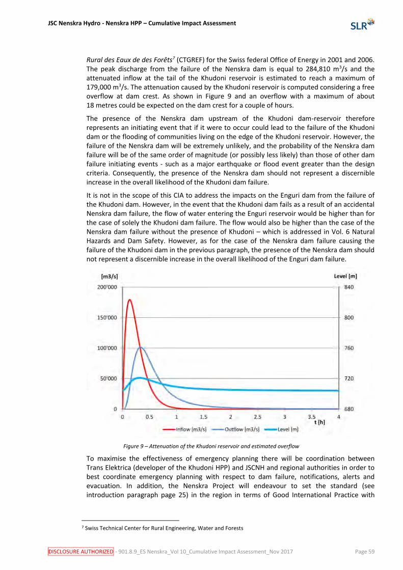
JSC Nenskra Hydro - Nenskra HPP – Cumulative Impact Assessment
DISCLOSURE AUTHORIZED - 901.8.9_ES Nenskra_Vol 10_Cumulative Impact Assessment_Nov 2017 Page 59
Rural des Eaux de des Forêts7 (CTGREF) for the Swiss federal Office of Energy in 2001 and 2006. The peak discharge from the failure of the Nenskra dam is equal to 284,810 m3/s and the attenuated inflow at the tail of the Khudoni reservoir is estimated to reach a maximum of 179,000 m3/s. The attenuation caused by the Khudoni reservoir is computed considering a free overflow at dam crest. As shown in Figure 9 and an overflow with a maximum of about 18 metres could be expected on the dam crest for a couple of hours.
The presence of the Nenskra dam upstream of the Khudoni dam-reservoir therefore represents an initiating event that if it were to occur could lead to the failure of the Khudoni dam or the flooding of communities living on the edge of the Khudoni reservoir. However, the failure of the Nenskra dam will be extremely unlikely, and the probability of the Nenskra dam failure will be of the same order of magnitude (or possibly less likely) than those of other dam failure initiating events - such as a major earthquake or flood event greater than the design criteria. Consequently, the presence of the Nenskra dam should not represent a discernible increase in the overall likelihood of the Khudoni dam failure.
It is not in the scope of this CIA to address the impacts on the Enguri dam from the failure of the Khudoni dam. However, in the event that the Khudoni dam fails as a result of an accidental Nenskra dam failure, the flow of water entering the Enguri reservoir would be higher than for the case of solely the Khudoni dam failure. The flow would also be higher than the case of the Nenskra dam failure without the presence of Khudoni – which is addressed in Vol. 6 Natural Hazards and Dam Safety. However, as for the case of the Nenskra dam failure causing the failure of the Khudoni dam in the previous paragraph, the presence of the Nenskra dam should not represent a discernible increase in the overall likelihood of the Enguri dam failure.
Figure 9 – Attenuation of the Khudoni reservoir and estimated overflow
To maximise the effectiveness of emergency planning there will be coordination between Trans Elektrica (developer of the Khudoni HPP) and JSCNH and regional authorities in order to best coordinate emergency planning with respect to dam failure, notifications, alerts and evacuation. In addition, the Nenskra Project will endeavour to set the standard (see introduction paragraph page 25) in the region in terms of Good International Practice with
7 Swiss Technical Center for Rural Engineering, Water and Forests

JSC Nenskra Hydro - Nenskra HPP – Cumulative Impact Assessment
DISCLOSURE AUTHORIZED - 901.8.9_ES Nenskra_Vol 10_Cumulative Impact Assessment_Nov 2017 Page 60
regard to managing the risk of dam failure and emergency planning. This recommendation is referred to as:
• [CUM 8] Coordination between HPP developers and regional authorities with respect to dam failure emergency planning.
Transmittable diseases
Cumulative impacts in terms of transmittable diseases are associated principally with the mobilisation of the work forces for the construction of the hydropower projects in the Nenskra and Nakra valleys. The mobilisation of construction workers to the Nenskra valley represents a risk of increase in the prevalence of transmissible diseases amongst construction workers and possibly extending to local communities. The risk can be expected to be proportional to the percentage of workforce that is recruited from outside the region and this is related to the relative timing of the Khudoni and Nenskra construction works described in Section 4.6.3.
To maximise the effectiveness of management by individual projects, it is recommended that there is coordination between the HPP developers and regional authorities in order share findings of monitoring of the prevalence of transmittable diseases and to alert neighbouring projects and authorities in the event of increased incidence - so that a common and shared approach in controlling the issues can be implemented. In addition, the Nenskra Project will endeavour to set the standard (see introduction paragraph page 25) in the region in terms of Good International Practice with regard to managing the risk of transmittable diseases. This recommendation is referred to as:
• [CUM 9] Coordination between HPP developers and regional authorities with respect to managing transmittable diseases.
4.7 Microclimate Environmental impacts of some very large dam-reservoirs include changes to the microclimate. In the case of large water bodies, the heat capacity of the reservoir water is higher than the natural surroundings and can alter air temperature and humidity around the reservoir as described below:
• During summer periods, the mass of water will absorb heat and water will evaporate – thus lowering ambient air temperatures nearby and increasing humidity.
• During winter periods, the water in the reservoir will release heat at a slower rate than that of the natural environment without the dam – thus slightly increasing air temperatures in the vicinity.
In the context of this CIA, the aim is to assess the cumulative impacts on microclimate from the combined impacts of the Khudoni reservoir and the Nenskra reservoir. The other hydropower projects in the region are run-of-river schemes and consequently do not contribute to microclimate impacts as they do not require water storage reservoirs to be created.
4.7.1 Synthesis of the impacts on microclimate from the Nenskra reservoir
The Vol. 5 – Hydrology and water quality impact assessment includes an assessment of the impact of the Nenskra reservoir on microclimate.
One of the factors that greatly influences the scale and magnitude of any changes to the microclimate is the morphology of the reservoir site. The Nenskra reservoir will be located in a steep sided valley at an altitude of 1,300 metres, and the surrounding mountains reach

JSC Nenskra Hydro - Nenskra HPP – Cumulative Impact Assessment
DISCLOSURE AUTHORIZED - 901.8.9_ES Nenskra_Vol 10_Cumulative Impact Assessment_Nov 2017 Page 61
altitudes in the order of 3,000 metres. Downstream from the reservoir the valley descends with a regular gradient to the confluence with the Enguri River some 21 kilometres from the reservoir and at an altitude of 700 metres.
The assessment concludes that any discernible microclimate impacts during the summer months are expected to be detectable within the immediate area around the reservoir and limited to the upper Nenskra valley. Some small changes could be detected at Tita, some 5 kilometres downstream, but probably no further down the valley. The rationale for this prediction is as follows: the slight increase in humidity and slight lowering of temperatures in the summer months could be balanced or even masked by the predicted regional climate changes, which cause the opposite effects – i.e. reduced precipitation and increase in temperature. Also, the mechanism causing the changes in microclimate which is evaporation of water and release of heat from the reservoir water body is minimised by the low temperature of the inflow of water which is predominantly glacial melt water during the summer. The reservoir during this period of the year covers an area of 270 hectares, which represents 1.2 percent of the catchment, which covers 222 square kilometres.
During the winter months, the ambient temperatures are predominantly sub-zero, and the reservoir is at its lowest level and occupies an area of only 100 hectares. The reservoir could cause slightly localised warmer temperatures in the immediate area around the reservoir, but no discernible changes are expected at more than 1 kilometre from the limit of the reservoir.
4.7.2 Synthesis of the impacts on microclimate from the Khudoni reservoir
The Khudoni reservoir will occupy an area of 530 hectares at an altitude of around 700 metres. It will occupy the lower reaches of the Nenskra valley – some 17 kilometres downstream from the Nenskra reservoir – and part of the Enguri valley. The reservoir is situated a few kilometres upstream form the Enguri reservoir, and from a microclimate impact perspective could be considered as a continuation of the Enguri reservoir. The Enguri reservoir covers an area of 1,350 hectares, and consequently the Khudoni reservoir represents a 40 percent increase in reservoir area and the total area of the Enguri and Khudoni reservoirs will be almost 1,900 hectares.
The microclimate changes from the Enguri and Khudoni reservoirs can be expected to be of a greater magnitude than those of the Nenskra reservoir. This is principally because the reservoir covers an area 5 times that of the Nenskra reservoir, but also because the morphology of the terrain is more favourable for the movement of volumes of air to move along the bottom of the Enguri valley.
The nature of the microclimate changes for the Enguri and Khudoni reservoirs are expected to be similar to those of the Nenskra reservoir, which are a slight localised increase in humidity and lowering of temperatures in the summer months and a slight warming of air around the reservoir in the winter. It is not within the scope of this CIA to make an assessment of the changes to the microclimate from Khudoni, but it can be expected that the changes in microclimate will be relatively localised and if they are detectable will be limited to the Enguri valley and the lower reaches of the Nenskra. This is because in summer, the cooler air around the reservoir is denser than surrounding warmer air, so there will be a tendency for the cooler air to remain around the reservoir and it is not expected to move up the valley gaining 600 metres in altitude. In winter, discernible changes in the microclimate are not expected because of the high recharge rate of the reservoirs with cold water, which will minimise the mechanism of releasing heat from the reservoir because of the higher heat capacity of the water compared to the surroundings.

JSC Nenskra Hydro - Nenskra HPP – Cumulative Impact Assessment
DISCLOSURE AUTHORIZED - 901.8.9_ES Nenskra_Vol 10_Cumulative Impact Assessment_Nov 2017 Page 62
4.7.3 Cumulative impacts on microclimate
Taking into account the scale and magnitude of the expected changes to microclimate from the Nenskra and the Enguri/Khudoni reservoirs considered individually - as described above – it is predicted that there will probably be no discernible cumulative impacts on the microclimate. This is because the changes to the microclimate from the Nenskra reservoir are not expected to geographically overlap with the areas affected by changes in microclimate resulting from the Khudoni reservoir as discussed in the paragraphs below.
During the summer months
During the summer months, the Nenskra reservoir microclimate changes are expected to be geographically limited to the immediate area of the Nenskra reservoir in the upper reaches of the Nenskra River. The slightly cooler air around the reservoir may descend towards Tita, but is not expected to travel the 17 kilometres to Chuberi or further to the Khudoni reservoir. The Enguri/Khudoni reservoirs microclimate changes are expected to be geographically limited to the Enguri valley around the Enguri and Khudoni reservoirs, and the lower Nenskra valley. Cooler air being denser than warm air is not expected to travel up the Nenskra valley to the Nenskra reservoir area or to Tita, which is some 12 kilometres up the valley and about 400 metres higher in altitude. Consequently, no cumulative impact on microclimate is expected.
During the winter months
During the winter months when the microclimate change is for the air around the reservoirs to be slightly warmer than the surroundings, again no cumulative impact on microclimate is expected. The Nenskra reservoir covers an area of about 100 hectares and no discernible change in microclimate is expected.
4.8 Reservoir triggered seismicity
4.8.1 Introduction
There is general scientific consensus that there is a relationship between creation of some large dam-reservoirs and a detectable change the frequency of seismic events. In view of this and the recommendations of the International Commission on Large Dams (ICOLD), the possibility of Reservoir Triggered Seismicity (RTS) in the Nenskra Project area has been studied by the Project as part of the Earthquake Hazard Analysis. The study has concluded that it is generally accepted that RTS is triggered by reservoir impoundment by either (i) the weight of the water on the earth’s crust may cause movements on a fault, or (ii) the change in pore pressure due to water infiltration may have triggered slip on a fault. In most cases, the 2 mechanisms occur concurrently, but on different time scales.
At depths greater than several kilometres (typical depths of earthquake generation), both the weight effects and the pore pressure effects are small. This is why it is believed that the crust beneath the reservoir must be critically stressed by tectonic forces and zones of weakness (faults) must be present. The reservoir merely adds a small perturbation to the state of stress and triggers fault displacement, thus earthquake. Such earthquake would have occurred anyhow at a later date under the natural conditions of stress accumulation. The presence of the reservoir only hastened its occurrence.
The incidence of even very small increments of stress is well illustrated by the fact that, in several well documented cases of RTS, earthquakes tend to occur in close time relationship with sharp changes in reservoir level, even of moderate amplitude, rather than at maximum

JSC Nenskra Hydro - Nenskra HPP – Cumulative Impact Assessment
DISCLOSURE AUTHORIZED - 901.8.9_ES Nenskra_Vol 10_Cumulative Impact Assessment_Nov 2017 Page 63
reservoir level. As regards the factors likely to influence the level of RTS hazard, The Project’s Earthquake Hazard Analysis refers to the work of Baecher and Keeney (1982), summarizing the results of a worldwide study, and which concludes that the occurrence of RTS would increase:
• With increasing reservoir depth;
• With increasing reservoir volume;
• When active fault is present in the vicinity of or across the reservoir;
• Among reservoir on sedimentary strata, rather than granitic, metamorphic or volcanic basement;
• Among reservoir on carbonate strata, rather than any other sedimentary strata, and
• Among reservoir in areas of extensional tectonics.
4.8.2 RTS hazard for the Nenskra reservoir
The Project’s Earthquake Hazard Analysis reports that when considering the natural stress environment of the Nenskra reservoir and the nature of the underlying rocks, the conditions appear relatively favourable for minimising the scale of potential RTS at the reservoir. In a context of compressive horizontal stress with reverse faulting mechanism, the increase of the vertical load will have a stabilizing effect and the natural permeability of the crystalline basement is expected to be very low, and infiltrations at depth will be minimal if any. Nevertheless, the possibility of occurrence of some RTS cannot be fully excluded. There are at present no feasible way to assess the maximum magnitude of RTS earthquakes, but events with a magnitude of 4.5 on the Richter Scale and possibly slightly more must be regarded as possible. To put this into context, earthquakes with a magnitude in the range of 3 to 3.9 are classed as “minor” and magnitudes in the range of 4 to 4.9 are classed as “light”. Seismic events in the range of 2.5 to 5.4 are often felt, but do not cause damage
4.8.3 RTS hazard for the Khudoni reservoir
It is not in the scope of the CIA to assess the RTS hazards of the Khudoni reservoir. However, the RTS hazard for Khudoni could be expected to represent a greater likelihood of RTS compared to the Nenskra reservoir because of the larger size of the reservoir and its proximity to faults. The Khudoni reservoir will occupy an area of 530 hectares. The reservoir is situated a few kilometres upstream from the Enguri reservoir, and from a RTS perspective could be considered as a continuation of the Enguri reservoir. The Enguri reservoir covers an area of 1,350 hectares, and consequently the Khudoni reservoir represents a 40 percent increase in reservoir area and the total area of the Enguri and Khudoni reservoirs will be almost 1,900 hectares. By comparison, the Nenskra reservoir occupies an area of 370 hectares in summer and 100 hectares in winter. The Khudoni dam will be constructed in close proximity to a known fault and the tail of the reservoir is in proximity to a fault – as illustrated in Figure 10 overleaf.
4.8.4 Cumulative RTS hazards
The Project’s Earthquake Hazard Analysis reports that there is general scientific consensus that RTS occurs in areas where there is existing seismic activity and that the magnitude of RTS is not greater than that of the natural seismicity. The reservoir adds a small perturbation to the state of stress of faults and triggers fault displacement, thus causing a seismic event. It is considered that such an earthquake would have occurred anyhow later, under the natural conditions of stress accumulation. The presence of the reservoir only hastens its occurrence. When considering this, in the context of the Nenskra, Khudoni and Enguri reservoirs, it can be considered that the combined physical presence of the 3 reservoirs will therefore probably not cause a RTS event of greater magnitude than that of any one of the 3 reservoirs considered

JSC Nenskra Hydro - Nenskra HPP – Cumulative Impact Assessment
DISCLOSURE AUTHORIZED - 901.8.9_ES Nenskra_Vol 10_Cumulative Impact Assessment_Nov 2017 Page 64
individually or the case without any of the dams. However, the additional stress that is put on the faults by the combination of the 3 reservoirs could increase the likelihood or frequency of RTS.
There are a number of faults situated between the Nenskra and Khudoni reservoirs as shown in Figure 10 overleaf. The faults are at similar distances from both the Nenskra and Khudoni reservoirs, and could be influenced by both the reservoirs, and the possibility of occurrence of RTS cannot be excluded. As for the Nenskra reservoir alone, there are at present no feasible way to assess the maximum magnitude of RTS earthquakes, but events with a magnitude of 4.5 on the Richter Scale and possibly slightly more must be regarded as possible, which although they can be felt are not expected to cause damage to buildings.
Source: JSC Nenskra Hydro, 2016
Figure 10 – Main fault segments in the project region
In order to best manage any perceived RTS – that could in reality be either from a single scheme, the cumulative effect of the 3 schemes or from normal seismic activity – there shall be coordination between the Khudoni, Nenskra and Enguri operators. The coordination shall be with respect to monitoring of seismic activity, alert in case of detected increase and coordinated actions in the event that an increase in seismic activity is detected. This measure is referred to as:
• [CUM 10] Coordination between HPP developers and regional authorities with respect to monitoring seismic activity and subsequent actions to reduce RTS.
JSC Nenskra Hydro - Nenskra HPP – Cumulative Impact Assessment
DISCLOSURE AUTHORIZED - 901.8.9_ES Nenskra_Vol 10_Cumulative Impact Assessment_Nov 2017 Page 65
5 Synthesis of impacts, significance and commitments
Table 10 next pages summarise all cumulative impacts, as well as the mitigation, compensation, safety and improvement measures (JSCNH commitments) identified as part of the CIA. The summary table refer to the measures marked [CUM] throughout this report. The [CUM] measures are not necessarily listed in the sequential order of their number.

JSC Nenskra Hydro - Nenskra HPP –Cumulative Impact Assessment
DISCLOSURE AUTHORIZED - 901.8.9_ES Nenskra_Vol 10_Cumulative Impact Assessment_Nov 2017 Page 66
Table 10 - Summary of cumulative impacts and commitments
Environmental or Social Value
Impact Producing Factor Phase Assessment of significance without mitigation or compensation
High Hi - Moderate M - Low Lo- Negligible Ne
Commitments
(in addition those to address Nenskra impacts)
Predicted residual impact
Management Action where the mitigation or compensation measure is addressed in the ESMP
Earl
y W
ork
s
Mai
n c
on
stru
ctio
n
Res
ervo
ir F
illin
g
Op
erat
ion
[+] positive, [-] negative
Likelihood, Magnitude, Extent, Duration
River hydrology and geomorphology
Modified flows in the Nenskra, Nakra and Enguri as a results of Nenskra HPP, various run-of-river HPPs and the Khudoni HPP
■ ■ Ne [-] Certain [CUM 1] Cooperation with Nakra HPP developers with respect to the Nakra River management of flow and sediment management upstream of the water intake built by the Nenskra HPP.
Ne Stakeholder Engagement process - SEP5.
River and reservoir water quality
Modified water quality in the Nenskra and the Khudoni reservoirs during the first 2 – 3 years after reservoir filling
■ ■ Lo [-] Probable Not applicable Lo Not applicable
Fish resources and fish habitat
Modified flows and changes in sediment transport capacity in the Nenskra, Nakra and Enguri as a results of Nenskra HPP, various run-of-river HPPs and the Khudoni HPP
■ ■ Ne [-] Certain [CUM 2] Coordination with the Government of Georgia (Ministry of Environment and Ministry of Energy) to ensure that run-of-river schemes in the Nenskra and Nakra catchment are required to be equipped with ecological flows and fish passes.
[CUM 3] Coordination with Nakra HPP developers with respect to ecological continuity along the Nakra River.
Ne Stakeholder Engagement process - SEP 5.
Terrestrial ecosystems and biodiversity
Loss of habitat and disturbance as a results of Nenskra HPP, various run-of-river HPPs and the Khudoni HPP
■ ■ ■ ■ Ne [-] Certain Not applicable Ne Not applicable
Social impacts - Social license to operate
Social (and to a lesser extent environmental impacts) as a whole for HPP projects in general in the watershed
■ ■ ■ ■ Hi [-] Probable [CUM 4] Public disclosure of the potential risks of cumulative impacts in terms of social licence to operate, additional consultations with communities regarding cumulative impacts and public disclose
M Lo Stakeholder Engagement process - SEP5.
Social impacts - Land acquisition
Land acquisition and resettlement for Nenskra and Khudoni projects
■ ■ M [-] Certain [CUM 5] Public disclosure of potential risks of cumulative impacts in terms of land acquisition, the Nenskra Project’s land acquisition, and coordination with the developers of other hydropower projects in the Nenskra and Nakra valleys regarding potential overlap of land requirements and areas affected by the Projects.
Lo Stakeholder Engagement process - SEP5.
Social impacts - Employment
Temporary employment for concurrent Nenskra and Khudoni construction
■ ■ M [-] Possible [CUM 6] Public disclosure of the risk of potential cumulative impacts associated with recruitment of workers from outside the region and public disclosure of the numbers of local and non-local workers recruited by the Nenskra Project.
Lo Stakeholder Engagement process - SEP5.
Social impacts - Public infrastructure
Use of Jvari – Mestia road, and Khaishi – Chuberi road by concurrent Nenskra and Khudoni construction works
■ ■ M [-] Possible [CUM 7] Public disclosure of the risk of potential cumulative impacts associated with concurrent road use by hydropower projects and tourist traffic and public disclosure of the forecast Nenskra Project traffic and road use.
Lo Stakeholder Engagement process - SEP5.
Social impacts -Economic activities
Cumulative effects on tourism from concurrent Nenskra and Khudoni construction works and hindrance / disturbance on the Jvari – Mestia road
■ ■ Lo [-] Possible [CUM 5] Public disclosure of potential risks of cumulative impacts in terms of land acquisition, the Nenskra Project’s land acquisition, and coordination with the developers of other hydropower projects in the Nenskra and Nakra valleys regarding potential overlap of land requirements and areas affected by the Projects.
Lo Stakeholder Engagement process - SEP5.
Social impacts - Community health, safety and security
Knock-on effect of Nenskra dam rupture on Khudoni dam – and Enguri dam
■ ■ Lo [-] Possible [CUM 8] Coordination between HPP developers and regional authorities with respect to dam failure emergency planning.
Lo Emergency Preparedness Plan EPP1.
Cumulative effects on transmittable diseases from construction workers in the region because of concurrent Nenskra and Khudoni construction work
■ ■ M [-] Possible [CUM 9] Coordination between HPP developers and regional authorities with respect to managing transmittable diseases.
Lo Stakeholder Engagement process - SEP5.
Microclimate Physical presence of Nenskra reservoir in combination with Khudoni and Enguri
■ ■ Ne [-] Certain Not applicable Ne Not applicable
Reservoir Triggered Seismicity
Physical presence of Nenskra reservoir in combination with Khudoni and Enguri reservoirs
■ ■ Lo [-] Possible [CUM 10] Coordination between HPP developers and regional authorities with respect to monitoring seismic activity and subsequent actions to reduce RTS.
Lo Stakeholder Engagement process - SEP5.
JSC Nenskra Hydro - Nenskra HPP –Cumulative Impact Assessment
DISCLOSURE AUTHORIZED - 901.8.9_ES Nenskra_Vol 10_Cumulative Impact Assessment_Nov 2017 Page 67
References
Akhalkatsi M. (2015) Forest habitat restoration in Georgia, Caucasus Ecoregion. Published by Mtsignobari
Baecher G.B. and Keeney R.L. (1982) “Statistical examination of reservoir-induced seismicity” Bulletin of the Seismological Society of America, vol. 72, No. 2, pp. 553-559.
Fischer, T. B. (2007). Theory and Practice of Strategic Environmental Assessment, Earthscan, London.
Fichtner for LLC AquaEnergy, February 2016, Basic Design Report for Nakra HEPP Project, Executive Summary
Gamma Consulting Limited (2015), Environmental and Social Impact Assessment Report for the Project on the Construction and Operation of Nenskra HPP
IFC (2013), Good Practice Handbook on Cumulative Impact Assessment and Management for the Private Sector in Emerging Markets.
KfW (2015) Pre‐feasibility Study for a Protected Area Project in Racha, Lechkhumi and Svaneti (Georgia), Draft Report Version 1 - Commissioned by GFA Consulting group acting on behalf of the KfW
JSCNH, (2016) Nenskra HPP, Georgia – Basic Design – Earthquake Hazard Assessment - Revision 000, Prepared by Lombardi, issued April 2016
Ministry of Energy (2017a) Ongoing Renewable Power Projects, 26 October 2017 http://www.energy.gov.ge/projects/pdf/pages/On%20going%20Investment%20Projecs%201779%20eng.pdf Consulted 1 November 2017.
Ministry of Energy (2017b) List of Potential Renewable Project, not dated http://www.energy.gov.ge/projects/pdf/pages/List%20of%20Potential%20HPPs%201759%20eng.pdf Consulted on 1 November 2017.
Ministry of Energy (2011) Khudoni – Environmental and Social Impact Assessment – Final Report. ARS Progetti SPA and BRL [online] Available at: http://siteresources.worldbank.org/INTGEORGIA/Resources/FM_Khudoni4589_ESIA_final_report_feb2011_FINAL_Chap_6fin_7_8_9_10_11_12.pdf [Accessed 23 April 2016]
Ministry of Environment and Natural Resources Protection of Georgia (2015) Georgia’s Third National Communication to the UNFCCC
Petrakov D.A. et al, (2007) Debris flow hazard of glacial lakes in the Central Caucasus. Debris-Flow Hazards Mitigation: Mechanics, Prediction, and Assessment, Chen & Major, eds. 2007 Millpress, Netherlands, ISBN 978 90 5966 059 5
The World Factbook (2016), https://www.cia.gov/library/publications/the-world-factbook/ consulted March 2016
UNDP (2014), Upper Svaneti Adaptation Strategy to the Climate Change

JSC Nenskra Hydro - Nenskra HPP –Cumulative Impact Assessment
DISCLOSURE AUTHORIZED - 901.8.9_ES Nenskra_Vol 10_Cumulative Impact Assessment_Nov 2017 Page 68
Minutes of stakeholder consultations

Nenskra HPP Supplementary E&S Studies Cumulative Impact Assessment Meeting
MINUTES 05/04/2016 12:30 – 14:00 CHUBERY TOWN HALL
TENDEES
Rodam Gvarmiani (representative of the Sakrebulo of Mestia Municipality) Giorgi Ansiani (Community Liaison Officer of JSC Nenskra HPP in Chuberi) Nino Vibliani (representative of the Gamgebeli of Chuberi) Tengiz Gvarmiani (representative of the Gamgebeli of Nakra) Loreta Tserediani (inhabitant of Chuberi) Ogeuk Kwon ( JSC Nenskra) SangHoon Kim (JSC Nenskra) Medgar Tchelidze (SLR) Nicolas Glenat (SLR) Clement Repussard (SLR)
NOTE TAKER C. Repussard and N. Glenat
M. Tchelidze (SLR) and C. Repussard (SLR) explain the reasons of the meeting. The meeting aims to discuss cumulative impacts of Nenskra HPP with other potential HPPs. Cumulative impact definition is explained. A map of all HPP within the Enguri watershed is shown and explained. Then all participants are then asked to identify and described potential cumulative impacts. At the end of the meeting, some specific requests were expressed by the representatives of the Chuberi and Nakra villages. The cumulative impacts identified by the attendees are listed below, followed by a synthesis of the requests expressed by the representatives of the local population. The signed list of attendees is presented in Annex.
CUMULATIVE IMPACT
DESCRIPTION
Climate Change
The first cumulative impact anticipated by the local population representatives is climate change. They fear that humidity levels will increase in the region.
Region development
One of the participants express that the development of HPP is a first step in the economic development of the region. There will be negative impacts mainly on big projects, whereas on small HPP, such as run-off river schemes, the negative impacts will be less important, or not significant.
Lack of local social license to operate / lack of information
All participants explain that there is a lack of official information on HPP development in the region. Rumors are widespread, and contradictory information is disseminated by different stakeholders, NGOs, without any clear coordination or hierarchy. Therefore, a climate of distrust is comforted, especially after the experience of the Khudoni Project. A strong opposition on HPP projects is growing, not only against the Projects being implemented, such the Nenskra Project, but also for HPP projects in principle. After seeing the Enguri Dam, a significant part of the population in the region fears that the whole Svaneti region is going to be flooded.
Employment
Employment during construction of the HPP is seen as a positive cumulative impact. But it is stressed that local employment – defined as the employment of the people living in the valleys directly affected – should be maximized. Also, the recruitment process should be explained more clearly.

Land acquisition - land prices are too low.
The process of land and assets valuation for the land acquisition processes is not deemed appropriate. Valuation results are considered to be too low by the local population. Resettlement is also an important negative impact.
Impacts on fishes habitat
An important potential cumulative impact is the loss of spawning areas or the modification of river habitats.
Impact on water supply systems
The attendees express concerns about erosion following the river bed modifications. Many HPP can damage many river sections. On some HPP projects in Georgia, modification of riverbeds leaded to drying-up the springs used by the local people for their water supply systems. So the development of many HPP in the region could affect the local water supply systems.
Lack of local benefits
Overall, all participants asked what will be the benefits of all these HPP development for the local population. There is not any clear local and sustainable benefit for them.
DESCRIPTION OF EXPRESSED REQUESTS
Nino Vibliani (representative of the Gamgebeli of Chuberi)
Nino Vibliani expressed 2 requests, one concerning a lack of information about the impacts of the powerhouse construction on the Lakhani community, the second one about a water supply project from KOICA. 1. Impacts of the power house on the Lakhani community N. has been asked by some villagers from Lakhani community what will be the impacts on the village. These villagers are regularly protesting and the answers given so far do not convince them. She would like to have some maps and documents officially endorsed by the Project showing that there will not be any impacts. Topics should be
Land acquisition: confirm and prove that there will not be any land acquisition/resettlement in Lakhani
Noise: confirm that there will not be any impacts
Construction activities: confirm what will be the construction activities, and confirm that there will be no risks for the people of Lakhani, form activities such as blasting or drilling.
River Flow downstream of the PowerHouse: villagers are concerned about the strength of the water that will be release by the turbines. They ask the Project to build a structure to lower the strength of the water released by the turbine to ensure that there will not be any impact o n Lakhani community.
Potential underground damages to the village: the villagers want confirmation that there will not be any pipeline constructed underground of the village, or that there will not be any water flowing underground of Lakhani.
Transmission Line 2. KOICA water supply project. A team of surveyors visited the valley to prepare a water supply project for KOICA. A meeting has then been held with a representative of KOICA and another of the Mestia Municipality. During this meeting, it was explained that the KOICA project might not target the Nenskra or the Nakra valley. Nino Vibliani asks that the project take care of this issue with KOICA and that the Nenskra and Nakra valleys are targeted by KOICA. She fears that the Mestia Municipality might try to influence KOICA to target another valley instead of Nakra and Nenskra. Mr. Kwon (JSC Nenskra) explains that JSC Nenskra will not build the transmission line, and that it will be the Government Responsibility to construct it. He also explains that he will report the points raised and that answers will be provided by JSC Nenskra when possible. Regarding KOICA, it is explained that no decision has been made so far, as this is only the surveys for the budgeting stage of the KOICA Project.

Rodam Gvarmiani (representative of the Sakrebulo of Mestia Municipality)
Rodam Gvarmiani expresses his first request as a representative of Mestia Municipality. He explains that there are some rumors that JSC Nenskra will not pay the Land Tax to Mestia Municipality. If this is true, this can trigger some opposition from some part of the local population. The Mestia Municipality needs to know what will be its benefits of the Project. He asks if Mestia Municipality can be informed of the content of the contract signed between the Government of Georgia and JSC Nenskra regarding the Land Tax. As a representative of Nakra communities, he also asks more information on the potential impact of the Nenskra Project on natural Hazards, and the potential mitigation measures that will be implemented.

Annex : Signed Attendees’ list