Embed Size (px)
Citation preview
Visualizing the volcanic history of the
Kaapvaal Craton using ArcGIS
Max Adolfsson Dissertations in Geology at Lund University,
Bachelor’s thesis, no 385
(15 hp/ECTS credits)
Department of Geology
Lund University
2014


Visualizing the volcanic history of the Kaapvaal Craton using ArcGIS
Bachelor’s thesis Max Adolfsson
Department of Geology Lund University
2014

Contents
1 Introduction ....................................................................................................................................................... 7
2 Materials and Methods ...................................................................................................................................... 7
3 Results – ’Time slice’ division and maps .......................................................................................................... 8
3.1 Time slice 1: ca. 3.07– 2.60 Ga 8
3.1.1 Dominion Group (ca. 3.074 Ga) 8
3.1.2 Pongola Supergroup (ca. 2.98– 2.60 Ga) 8
3.1.3 Witwatersrand Supergroup (ca. 2.985– 2894 Ga) 12
3.2 Time slice 2: ca. 2.85– 2.60 Ga 12
3.2.1 Ventersdorp Supergroup (ca. 2.78– 2.70 Ga) 12
3.3 Time slice 3: ca. 2.65– 2.05 Ga 16
3.3.1 Transvaal Supergroup (ca. 2.65– 2.05 Ga) 16
3.4 Time slice 4: ca. 2.05– 1.95 Ga 18
3.4.1 Bushveld Complex and Rooiberg Group (ca. 2.05– 1.95 Ga) 18
3.5 Time slice 5: ca. 1.95– 1.87 Ga (1.45– 1.20 Ga for Pilanesberg) 18
3.5.1 Waterberg Group, Soutpansberg Group, Olifantshoek Supergroup and the Pilanesberg Alkaline 18
Province
3.6 Time slice 6: ca. 1.1 Ga 20
3.6.1 Umkondo Igneous Province (ca 1106– 1112 Ma) 20
4 Discussion.......................................................................................................................................................... 23
4.1 Time slice 1 23
4.2 Time slice 2 23
4.3 Time slice 3 23
4.4 Time slice 4 24
4.5 Time slice 5 24
4.6 Time slice 6 24
4.7 Kaapvaal barcode 24
5 Summary ........................................................................................................................................................... 25
6 Acknowledgements........................................................................................................................................... 26
7 References ......................................................................................................................................................... 26
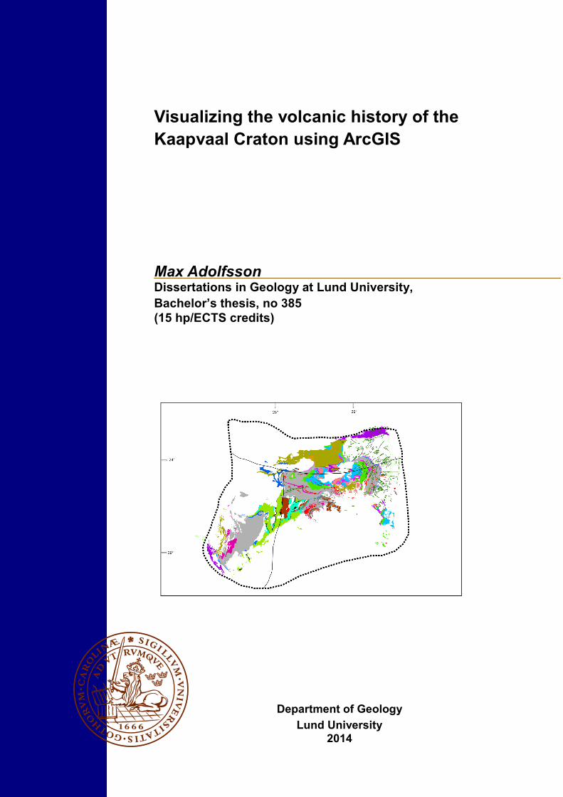
Cover Picture: Highlighted volcanic and intrusive units of the Kaapvaal Craton

Visualizing the volcanic history of the Kaapvaal Craton using
ArcGIS
MAX ADOLFSSON
Adolfsson, M., 2014: Visualizing the volcanic history of the Kaapvaal Craton using ArcGIS. Dissertations in
Geology at Lund University, No. 385, 28 pp. 15 hp (15 ECTS credits).
Keywords: Kaapvaal Craton, ArcGIS, time slice maps, geochronology, correlations.
Supervisor(s): Ashley Gumsley, Ulf Söderlund
Subject: Bedrock geology
Max Adolfsson, Department of Geology, Lund University, Sölvegatan 12, SE-223 62 Lund, Sweden. E-mail:
Abstract: The Kaapvaal Craton comprises a piece of well preserved Archaean crust making it a valuable subject in
the pursuit of palaeocontinental reconstruction. The aim of this study was to visualize the volcanic events of the
craton through time using arcGIS and available geochronological data. This was done by creating a number of so
called ‘time slice’ maps that represent time periods from ca. 3 Ga to 1 Ga. These maps show the spatial and tem-
poral distribution of the volcanic events occurring within the craton borders. Literary studies were made to recog-
nize areas in need of additional geochronologic data in order to resolve uncertainties such as age constrains and
correlations between formations. The onset of the Ventersdorp volcanism and the following transition to the pre-
dominantly sedimentary Transvaal Supergroup are examples of areas in need of additional studies in order to un-
derstand when these events occurred and how they relate to each other. The addition of new ages, such as the 2.4
Ga age for the Westerberg sill could yield new correlations that could contribute to further understanding the tec-
tonic and magmatic events that occurred during the time period of the Transvaal Supergroup. A Kaapvaal Craton
barcode map was produced using the existing geochronological data with addition of more recent data. This pro-
vides an up to date picture of the temporal distribution of volcanic events. This overview of the Kaapvaal Craton
through time helps recognizing the areas in need of further studies in order to give way for a more complete under-
standing of the evolutionary trends of the craton.

Visualisering av den vulkaniska historian på Kaapvaal kratonen
med hjälp av ArcGIS
MAX ADOLFSSON
Adolfsson, M., 2014: Visualizing the volcanic history of the Kaapvaal Craton using ArcGIS. Dissertations in
Geology at Lund University, No. 385, 28 pp. 15 hp (15 ECTS credits).
Nyckelord: Kaapvaal Craton, ArcGIS, time slice maps, geokronologi, korrelationer
Handledare: Ashley Gumsley, Ulf Söderlund
Ämnesinriktning: Berggrundsgeologi
Max Adolfsson, Geologiska institutionen, Lunds universitet, Sölvegatan 12, 223 62 Lund, Sverige. E-post:
Sammanfattning: Kaapvaal kratonen består av ett välbevarat fragment av arkeisk jordskorpa som utgör ett
värdefullt objekt vid palaeokontinentala rekonstruktioner. Syftet med den här studien var att visualisera vulkaniska
händelserna i kratonen genom tiden med hjälp av ArcGIS och tillgängliga geokronologiska data. Detta gjordes
genom att skapa ett antal så kallade ’time slice’ kartor som representerar tidsperioder från ca . 3 Ga till 1 Ga. Dessa
kartor visar den spatiala och temporala fördelning av vulkaniska händelser inom kratonens gränser. Litteraturstudier
gjordes för att finna områden i behov av ytterligare geokronologisk data för att reda ut oklarheter, så som ålder
förhållanden och korrelationer mellan formationer. Uppkomsten av Ventersdorp-vulkanismen och följande
övergång till den sedimentärt dominerade Transvaal supergruppen är exempel på områden i behov av ytterligare
studier för att förstå när dessa händelser inträffade och hur de relaterar till varandra . Tillskottet av nya åldrar, till
exempel 2,4 Ga åldern för ’Westerberg sills’ skulle kunna ge nya korrelationer som kan bidra till att ytterligare
kunskap om de magmatiska och tektoniska händelser som inträffade under Transvaal-tidsperioden. Genom
användning av befintliga och nyare geokronologiska data producerades en ’barcode map’ för Kaapvaal Cratonenal
som ger en uppdaterad bild av den tidsmässiga fördelningen av vulkaniska händelser. Denna översikt av den
Kaapvaal kratonen genom tiden erkänner områden i behov av ytterligare studier för att få en mer fullständig
förståelse för de evolutionära trender som präglat kratonens utveckling.

7
1 Introduction The Kaapvaal Craton in southern Africa comprises a
piece of early Earth history (see Fig. 1. for spatial dis-
tribution) . Together with the Pilbara Craton in Aus-
tralia, the Kaapvaal Craton is one of the most well
preserved pieces of Archaean crust. The cratons
unique preservation of old crust enables this fragment
to present a view into the events and processes that
were active during early crustal development of the
Earth (Lana et al. 2003). Eglington & Armstrong
(2004) use a database system developed by Eglington
(2000) called DateView to compile a geological and
geochronological database for South Africa, Swazi-
land, Lesotho and Botswana which together with
ArcGIS database was used to produce several “time
slice” maps. The purpose of these so called “time
slice” maps was to visualize the tectonic evolution and
development of the Kaapvaal Craton through time and
timing of the formation of major geological units.
Through time the lithospheric crust may break up
or join together with different crustal fragments due to
the tectonic events that controlled the dynamics on
Earth. By matching crustal fragments spatially with
the same age using geochronological methods, pieces
of crust can be matched and supercontinents recon-
structed. This approach is known as magmatic
‘barcoding’ and provides a deeper understanding of
early Earth history, and also which continents were
contiguous (Bleeker & Ernst 2006).
Large Igneouse Provinces (LIPs)
are formed during extensive, but short- lived magmatic
events associated with continental break-up (maximum
of ~ 50 Ma, usually less than 10 Ma) and consists of
varieties of mainly mafic to ultra mafic volcanic rocks
such as sills, dykes, mafic intrusions and flood basalts
(Coffin & Eldholm 1992). These large (> 100,000
km3) igneous crustal provinices provides the necessary
tools for barcoding and palaeocontinental reconstruc-
tion (Ernst et al. 2013). By providing a precise geo-
chronologic age dating of these short-lived magmatic
events associated with LIPs a magmatic ‘barcode’ is
created. Combining this ‘barcode’ with additional
information such as geological setting, geochemistry,
palaeomagnetism and spatial distribution provides a
powerful tool in understanding palaeocontinetal set-
tings (find reference Bleeker and Ernst 2006).
The aim with this study is to update and
revise the previous work of Eglington and Armstrong
(2004) focusing on the volcanic units of the Kaapvaal
Craton, especially in light of the new geochronological
age dating achieved using baddeleyite as opposed to
zircon; the latter which might be xenocrysts in some
cases. During emplacement of lavas and tuff there is a
possibility of contamination of xenocrystic zircons that
originate from older rocks. If a sample of lava holds
these inherent zircons the age obtained when tested
will not represent the age of crystallization for the la-
va. In addition, during metamorphosis baddeleyite
recrystallizes to zircon due to reaction with silica
which in turn alters the age data when tested. Dating
performed on baddelyiete is therefore more certain due
to the fact that it is igneous and can not form during
metamorphosis (Söderlund et al. 2013).
By illustrating the spatial distribution of volcanic
Groups and Supergroups of the Kaapvaal Craton, a
new perspective on major tectonic events and the asso-
ciated volcanics is provided, which in turn may help
with the visualization of the Craton evolution through
time. This is done by producing ‘time slice’ maps in
ArcGis, similar to those of Eglington and Armstrong
(2004) and a magmatic barcode for the Kaapvaal vol-
canic and intrusions.
This study will then attempt to recognize and em-
phasize where further studies are required to give a
more complete and precise reconstruction and barcode
of the Kaapvaal Craton evolution.
2 Material and Methods ArcGIS has been used to construct overview maps of
the Kaapvaal Craton containing information such as
geological-, and temporal geochronological data from
geological maps and literature. This allows the spatial
extension of the different volcanic stratigraphic units
to be interpreted. Five existing geological maps,
produced by the Council of Geoscience in South
Africa, where georeferenced using ArcMap to produce
a single coherent map with using the WGS 1984
coordinate system. A geopfysical map of the Kaapvaal
Craton area was used to highlight the craton boundry
(see Fig.2.)
The volcanic units where marked and highlighted
as separate polygons on the map. The polygons of
different units where made as either single or grouped
polygons depending on similarities /dissimilarities in
age, lithology and distribution. Thereafter these groups
of polygons where divided into time slice units
representing time periods during certain tectonic
events where active. The dolerite dykes which are
marked as diabase on the maps are of varying ages and
Fig. 1. Overview map showing the extent of the Kaapvaal
Craton in relation to terrain and country borders. Modified
from Mukasa et al. (2013).

8
do therefore not always represent the same age as the
time slice itself. Although the general trends of these
dykes are illustrated on the maps.
The maps where described and conclusions on
evolutionary trends where drawn with the help of
literary studies and associated geochronological data.
Existing age dating for the volcanics and intrusions of
the Kaapvaal Craton was used to create an updated
craton ‘barcode’. This barcode toghether with the time
slice maps will help recognizing areas in need of
further dating and describing in the pursuit of a more
complete craton evolutionary reconstruction.
3 Results – ’Time slice’ division and maps
The results of this study are presented as time slice
maps as well as an overview literary study and
geochronologic data of the volcanic events occuring
on the Kaapvaal Craton.
3.1 Time slice 1: ca. 3.07– 2.60 Ga As is shown in Fig 3., the sediments and volcanics
during this period is distributed around the eastern and
central part of the craton. All these sediments and vol-
canic are deposited directly on to the granite-
greenstone basement. The northern parts of the craton
have no preserved volcanic sequences from this time
period, and neither do the western parts (compare Fig
1. with time slice maps for spatial distribution in rela-
tion to terrain- and country borders). This could be a
result of the accretionary events occurring on the west-
ern and northern margins during this time period
(Schmitz et al. 2004).
3.1.1. Dominion Group (ca. 3.074 Ga)
The sediments and volcanics of the Dominion group
are preserved around the center of the craton within
and east of the Vredefort Dome (see Fig. 4.).
The Dominion Group volcano- sedimentary se-
quence were deposited during a short period of rifting
(3.09- 3.07 Ga). (Schmitz et al. 2004). The Dominion
Group consists mainly of volcanic rocks, with some
minor sediments at the base, deposited during the
Mesoarchaean period. These successions where depos-
ited unconformably on the granitiod basement rocks.
Overlying the Dominion Group is the sedimentary
sequences of the Witwatersrand Supergroup (Jackson
1992). The Dominion Group can be subdivided into
three distinct formations (Grandstaff et al. 1986; Jack-
son 1992):
The Rhenosterspruit Formation: mainly a clastic
sedimentary unit, derived from weathered base-
ment rocks and fluvial enviroment, with increas-
ing abundance of interbedded volcanics in the
upper parts (Jackson 1992)
The Rhenosterhoek Formation: mainly lavas rang-
ing from mafic to intermediate composition. The
formation is discontinued by the overlying se-
quence making interpretations of different volcan-
ological parameters difficult. The lava contains
amygdales which indicates subaerial or subaque-
ous depostition (Grandstaff et al. 1986).
The Syferfontein Formation: the uppermost for-
mation of the Dominion Group and consists main-
ly of quartz-feldspar porphyries from felsic vol-
canic rocks with a sequence thickness up to 1500
m. Parts of the formation also include some basal-
tic to andesitic flows, breccias and tuffs
(Grandstaff et al. 1986). Armstrong et al. (1991)
dated this unit using the ion microprobe on zircon
yielding an age of 3074 ± 6 Ma. However, this
age result could have been due to contamination
of xenocrystic zircons since the only other geo-
chronological study done on this unit, by Niekerk
& Burger (1969) yielded an age of 2725 ± 75 Ma.
3.1.2 Pongola Supergroup (ca. 2.98-2.60 Ga)
The geochronological data from this time period is
presented in (Table 1).
The Pongola Supergroup consists of well preserved
volcanic and clastic sequences of Mesoarchean age,
which in turn overlies 3.1- 3.6 Ga crystalline granite-
greenstone basement rocks. The preservation of the
structure and geochemical features of these rocks
makes the Pongola Supergroup an interesting target to
better understand the crust-forming processes during
Meso- Archaean times. The area of this supergroup
Fig. 2. Geophysical map of southern Africa showing mag-
netic anomalities which were used to constrain the
Kaapvaal Craton border (Council of Geoscience in South
Africa 2006)

9
extends 120 km by 275 km, giving a minimum deposi-
tional area of 33,000km², and crosses over from South
Africa into Swaziland (Strik et al. 2007). The volcano-
sedimentary sequences of the Nsuze and Mozaan
Groups are situated in the south eastern part of the
Kaapvaal Craton, (see Fig. 5).
The Pongola Supergroup is subdivided into a lower
unit: the Nsuze Group (dominated by volcanic rocks)
and an upper sedimentary unit: the Mozaan Group
(Armstrong et al. 1982). Together these groups com-
prise a 12 km sequence of volcanic and clastic materi-
al, although the thickness varies significantly in differ-
ent areas (Armstrong et al. 1982). Both the Nzuse- and
Mozaan Group of the Pongola Supergroup were in-
truded at 2871±30 Ma by the Usushwana Suite
(Bumby et al. 2012). However, more recent badde-
lyite dating of the Usushwana Complex suggest that
the emplacement of took place earlier at ca 2989 Ma
ago(Olsson 2012). This suggests a connection with
eruption of early Nsuze lavas (Mukasa et al 2013).
The Nsuze Group (ca 2980-2960 Ma) is subdivided
into three different units with varying lithology. The
lower unit is comprised of the 800 m predominantly
sedimentary- deposits of the Matonga Formation dated
to 2980 ± 20 Ma on a inter-calated lava using U-Pb on
zircons by Mukasa et al. (2013) . This is overlain by
the middle unit, the Nhlebela/Pypklipberg lava: a ca.
7500 m volcanic sequence.
The upper most unit is a volcaniclastic- sedimen-
tary sequence which varies in thickness from 500 to
600 m, comprising mostly the Agatha lava. This is
separate from the middle unit by a sedimentary pack-
age – the White Mfolozi Formation. It has been the
subject of several datings attempts, especially on the
Group/Formation Lithology Age (Ma) Method Reference
Nzuse Lavas 2978±2 U-Pb (radiogenic)
Zircon
Walraven and
Pape, J. Afr.
Earth Sci.
Nzuse Basalt 2883±69 Rb-Sr Whole rock -
Nzuse Rhyolite 2984±2.6 U-Pb (radiogenic)
Zircon -
Nzuse Volcanics 2985±1 U-Pb (radiogenic)
Zircon -
Nzuse Rhyolite 2940±22 U-Pb (radiogenic)
Zircon -
Nzuse Rhyodacite 2985±1 U-Pb (radiogenic)
Zircon -
Hlagothi Complex Layered sills 2866±2 U-Pb (radiogenic)
Baddeleyite Gumsley et al.
(2013)
Hlagothi Complex Layered sills 2874±2 U-Pb (radiogenic)
Baddeleyite Gumsley et al.
(2013)
Mozaan Quartz porphyry 2837±5 U-Pb (radiogenic)
Zircon Gutzmer et al.
(1999)
Mozaan Quartz porphyry* 2946±18 U-Pb (radiogenic)
Zircon Gutzmer et al.
(1999)
Mozaan Quartz porphyry* 3081±24 U-Pb (radiogenic)
Zircon -
Mozaan Quartz porphyry* 3093±18 U-Pb (radiogenic)
Zircon Gutzmer et al.
(1999)
Mozaan (lower sequence) Andesite 2980±10 U-Pb (radiogenic)
Zircon Ludwig (1999)
Mozaan (middle sequence) Rhyolite 2968±6 U-Pb (radiogenic)
Zircon Mukasa et al.
(2013)
Mozaan (inter-bedded
flow) Andesite 2954±9
U-Pb (radiogenic)
Zircon Mukasa et al.
(2013)
Usushwana Complex - 2989.2±0.8 U-Pb (radiogenic)
Baddeleyite Olsson (2012)
Usushwana Complex
- 2989.8±1.7 U-Pb (radiogenic)
Baddeleyite Olsson (2012)
Badplaas Dyke Swarm Dolerite 2967.0±1.1 U-Pb (radiogenic)
Baddeleyite Olsson et al.
(2010)
Badplaas Dyke Swarm Dolerite 2965.9±0.7 U-Pb (radiogenic)
Baddeleyite Olsson et al.
(2010)
Table 1. Geochronologic data of Pongola Supergroup units including the Usushwana Complex and the dolerite swarms of the
Badplaas Dyke Swarm. Ages and data collected from Dateview (Eglington 2000), Mukasa et al. (2013), Gumsley et al. (2013)
and Olsson et al. (2010) *Inherent zircons

10
Fig
. 3
. T
ime
slic
e m
ap 1
. sh
ow
ing t
he
spat
ial
dis
trib
uti
on
of
the
Pon
go
la-
and W
itw
ater
sran
d S
up
ergro
up
s as
wel
l as
th
e D
om
inio
n G
rou
p.

11
Fig
. 4
. T
ime
slic
e m
ap 1
.c s
ho
win
g i
n d
etai
l th
e sp
atia
l d
istr
ibu
tio
n o
f th
e W
itw
ater
sran
d S
up
ergro
up
. C
om
par
e sp
atia
l re
lati
on
to
Co
lesb
erg l
inea
men
t.

12
Agatha lava in the central parts of the basin. These
ages range from 2985 to 2940 Ma using U-Pb zircon
(Armstrong et al. 1982; Gumsley et al. 2013)
The sequences are located in the south eastern parts
of the Kaapvaal Craton (see Fig. 5. for more detail)
and the lithology of the volcanic unit gives the full
range from basalt to rhyolite rocks in the Nzuse Group
(Mukasa et al. 2013) . The sequence of the Nsuze
Group was previously believed to be a product of ex-
tensive and rapid rifting (Strik et al. 2007). This, ac-
cording to (Burke et al. 1985), explains the abrupt
changes in lateral thickness of the sequences deposited
in the Pongola Supergroup. Large volumes of volcanic
rocks are then preserved in these structures suggesting
a rift environment. The rifting period was then fol-
lowed by a shallow marine shelf environment during
which the sequence of the Mozaan Group was deposit-
ed (Strik et al. 2007). However, according to Mukasa
et al. (2013) the rapid deposition of lavas and the
structure of the volcanics of the Pongola Supergroup
does not share similarities with modern analogs of
rifting environments. The features of the volcanics
can, however be linked to a continental arc basin as
oppose to a rifting environment.
In the more eastern part of the craton an area of
extensive NE-SW dolerite dyke swarms intrudes and
cuts through eastern parts of the granitic basement (see
Fig. 5.). This swarm is termed the Badplaas dyke
swarm and was dated by (Olsson et al. 2010) at
2967.0±1.1 Ma using U-Pb on baddeleyite (TIMS),
which correlates to the Nzuse Group lavas. This means
that the basin possibly extended into this region too.
The layered sills of the Hlaghoti Complex intruded
the Pongola Supergroup ca. 2.87 Ga ago during mantle
plume activity in the southeastern part of the craton
(Gumsley et al. 2013) . According to Gumsley et al.(
2013) the intrusions and extensive magmatism occur-
ring during this time period could be linked to a new
‘Large Igneous Province’.
The Mozaan Group (ca 2860 Ma) is predominantly
made up of sedimentary material ranging from mud-
stones to sandstones interlayer with conglomerates and
BIF formations. These sedimentary units are inter-
bedded by a minor volcanoclastic units in the upper
sequence (Gold & Von Veh 1995). These units termed
the Tobolska and Gabela lavas were dated by Mukasa
et al. (2013) using U-Pb zircon (SIMS) method to
2954±9 Ma. This suggests a much older depositional
time of this group than previous suggestions, although
the presence of inherited zircons cannot be ruled out.
3.1.3 Witwatersrand Supergroup (ca 2.985- 2.894
Ga)
The Witwatersrand Supergroup is economically im-
portant, due to large gold deposits which are hosted in
this predominantly sedimentary basin. It has thus been
the subject to extensive exploration (Armstrong et al.
1991).
Overlying the older Dominion Group, the Witwa-
tersrand Supergroup consists of mainly coarse clastic
material with minor deposits of bimodal lava in the
upper successions, the Crown and Bird formations
(Jackson 1992; Guy et al. 2012).
This Supergroup was according to Schmitz et al.
(2004) a product of the crustal collision of the Kimber-
ly- and Witwatersrand block. This resulted in a sub-
duction of the eastern Witwatersrand block and depo-
sition of material in the forearc basin east of the sub-
duction zone. This could explain the absence of sedi-
ments and volcanics on the western part of the craton
since the forearc basin was formed within the eastern
Witwatersrand block. The two blocks are separated by
the NS trending Colesberg lineament (see Fig. 3 and
4.). (Schmitz et al. 2004)
The supergroup is divided into two groups: the
West Rand Group and the Central Rand group. The
sediments and volcanics of these groups are dirstribut-
ed around the central parts of the Kaapvaal Craton (see
Fig. 5. for more detail)
The West Rand Group constitutes the lower se-
quences of the Witwatersrand Supergroup. It consists
of mainly fluvial and marine sedimentary deposits
ranging from variations of mudstone, banded iron for-
mations to conglomerates. While this group mostly
contains marine sedimentary sequences, the uppermost
Jeppestown subgroup has a thin sequence of basaltic
lava known as the Crown lava (Guy et al. 2012). This
amygdaloidal flood basalt has a sequence thickness of
ca 60m and was deposited 2914 ± 8 Ma ago
(Armstrong et al. 1991), although as noted by the au-
thors, the presence of xenocrysts are possible .
The West Rand Group is uncomformably overlain
by the fluvial sediments of the Central Rand Group
ranging from conglomerates, sandstones and shale
(Manzi et al. 2013). The Central Rand Group contains
a minor volcanic sequence called the Bird lava which
is undated (Armstrong et al. 1991).
3.2 Time slice 2: ca 2.85- 2.60 Ga
3.2.1 Ventersdorp Supergroup (ca 2.78-2.70 Ga)
Geochronological data for the Ventersdorp Supergroup
is presented in Table. 2.
The Ventersdorp Supergroup has a vast distribution
stretching from the center to the south eastern and
north western parts of the Kaapvaal Craton. The Ry-
koppies dyke swarm is situated in the north eastern
parts of the craton separated from other Ventersdorp
units (see Fig. 6.).
The Ventersdorp Supergroup overlies the Witwa-
tersrand Supergroup with a angular unconformity
marking the end of the deposition of the Witwaters-
rand Basin (Eglington & Armstrong 2004). The suc-
cession thickness is at average 4 km, but ranges to 8
km (Armstrong et al. 1991). With an area extent of ca
300,000 km2 and relative short depositional time, this
Supergroup represent the most extensive “Large Igne-
ous Province” on the Kaapvaal Craton in the Neoar-
chean (Altermann & Lenhardt 2012).

13
This Supergroup is subdivided into three broad
groups consisting of various volcano- sedimentary
sequences. The lower most Klipriviersberg Group
composes a massive sequence of flood basalts reach-
ing a thickness of up to 2000 m and is geochronologi-
cally dated to 2714±8 Ma using U-Pb on zircon
(Armstrong et al. 1991). Although the Venterdorp Su-
pergroup could, according to (Wingate 1998) be dated
as far back as 2782±5 Ma if one regards the Derde-
poort basalts as the most basal sequence, and possibly
coeval with the Klipriviersberg. During this time the
Kanye volcanics were also deposited in the northern
part of the craton forming another sub-basin (Nelson et
al. 1999).
During the period of deposition of these flood bas-
alts the region experienced extensional tectonic activi-
ty which later resulted in NE-trending grabens
(Armstrong et al. 1991). Previous theories suggest the
collision of the Kaapvaal and Zimbabwe Craton as the
cause of the deposition (Burke et al. 1985). However,
the abcence of the vast Bushveld associated intrusion
(~2057 Ma) on the Zimbabwe Craton and equal ab-
sence of 2575 Ma Great Dyke magmatism on the
Kaapvaal Craton would suggest that this collision did
not take place until after the Bushveld intrusion
(Bleeker 2003).
The Klipriviersberg Group was then followed by
the Platberg Group (2709±4 Ma, Armstrong et al.
1991) during which clastic material and bimodal vol-
canics made up the deposited material. However, de
Kock et al. (2012) argue that the Platberg Group corre-
lates to the Hartswater Group at ~ 2730 Ma which
would mean that previous dating of the Platberg Group
done by Armstrong et al. (1991) is erroneous.
The upper most Pniel Sequence, or Group, which is
made up of a sedimentary- and a flood basalt for-
mation. This sequence has not yet been dated
(Armstrong et al. 1991).
The Pniel Succession is followed by the clastic
dominated Bothaville formation which in turn is over-
lain by the flood basalts of the Allanridge formation
(Van Der Westhuizen et al. 1991). The rift associated
Group/formation Lithology Age (Ma) Method Reference
Klipriviersberg Lava 2714±8 U-Pb (radiogenic)
Zircon Armstrong et al.
(1991)
Derdepoort Basalt 2782±5 U-Pb (radiogenic)
Zircon Wingate (1998)
Platberg Volcanics 2709±4 - Armstrong et al.
(1991)
Hartswater Tuff 2732.9±3.2 U-Pb (radiogenic)
Zircon de Kock et al. (2012)
Hartswater Porphyry 2724.3±5.8 U-Pb (radiogenic)
Zircon de Kock et al. (2012)
Allanridge Basalt - - -
Kanye Volcanics 2784±4 U-Pb (radiogenic)
Zircon Grobler and Walraven
(1993)
Kanye Rhyolite 2784.7±1.7 U-Pb (radiogenic)
Zircon Moore et al. (1993)
Kanye Rhyolite 2784.8±1.8 U-Pb (radiogenic)
Zircon Moore et al. (1993)
Makwassie Quartz porphyry 2709±4 U-Pb (radiogenic)
Zircon Armstrong et al.
(1991)
Makwassie Quartz porphyry 3480±7 U-Pb (radiogenic)
Zircon Armstrong et al.
(1991)
Makwassie Quartz porphyry 2706±22 U-Pb (radiogenic)
Zircon Gericke (2001)
Rykoppies Dykes 2683.1±1.6 U-Pb (radiogenic)
Baddelyite Olsson et al. (2010)
Rykoppies Dykes 2685.5±5.5 U-Pb (radiogenic)
Baddelyite Olsson et al. (2010)
Rykoppies Dykes 2662.3±2.5 U-Pb (radiogenic)
Baddelyite Olsson et al. (2010)
Rykoppies Dykes 2661.9±3.3 U-Pb (radiogenic)
Baddelyite Olsson et al. (2010)
Rykoppies Dykes 2658.9±3.2 U-Pb (radiogenic)
Baddelyite Olsson et al. (2010)
Rykoppies Dykes 2672.9±1.8 U-Pb (radiogenic)
Baddelyite Olsson et al. (2010)
Table. 2. Geochronologic data of the Ventersdorp Supergroup including the Rykoppies Dyke Swarm. Data collected from
Dateview (Eglington 2000), Wingate (1998) and Olsson et al. (2010).

14
Fig
. 5
. T
ime
slic
e m
ap 1
.b s
ho
win
g i
n d
etai
l th
e sp
atia
l dis
trib
uti
on
of
the
Po
ngola
Sup
ergro
up
wit
h a
sso
ciat
ed d
yk
es a
nd
sil
ls.

15
Fig
. 6
. T
ime
slic
e m
ap 2
. sh
ow
ing t
he
spat
ial
dis
trib
uti
on
of
the
Ven
ters
do
rp S
up
ergro
up
. C
om
par
e sp
atia
l d
istr
ibu
tion
of
the
Den
nil
ton
/Go
dw
an g
rou
ps
on t
ime
slic
e m
ap 3
.

16
flood basalts of the Allanridge formation makes up the
uppermost part of the Ventersdorp Supergroup. This
formation could be correlated to the Rykoppies dykes
(~2683-2686 Ma) which were formed during the
transition from the volcanic dominated Vent-
ersdorp Supergoup to the sedimentary dominated
Transvaal Supergroup. These Rykoppies Dykes may
also be related to the Transvaal Supergroup and its
basal proto-basinal fills. However, due to the insuffi-
ciency of geochronological data from this time period
these correlations are not certain (Olsson et al. 2010).
3.3 Time slice 3: ca 2.65-2.05 Ga 3.3.1 Transvaal Supergroup (ca 2.65- 2.05 Ga)
Geochronological data for the Transvaal Supergroup is
presented in Table. 3.
The sediments of the Transvaal Supergroup extend
throughout large areas from the western to north east-
ern parts of the craton. The older Vryburg and Black
Reef formations are preserved on the margin of the
younger Transvaal sediments, forming the base of the
succession, with some associated volcanism. The vol-
canic units of the Ongeluk- Hekpoort formations have
a large distribution area in the south western part of
the supergroup while smaller outcrops can be observed
in the more central and north eastern parts of the cra-
ton (see Fig. 7.).
The flood basalts of the Allanridge formation, rep-
resenting the upper most part of the Ventersdorp Su-
pergroup, was deposited during a renewed rifting peri-
od on the Kaapvaal Craton (Burke 1985b). This is sug-
gested to be the onset of the Transvaal sedimentary
deposition in proto-basinal fills which occurred at ca.
2657- 2659 Ma according to an unpublished report
(Olsson et al. 2010)
The Transvaal Supergroup can be divided into
three separate basins: the Griqualand West basin
(Botswana), the Kanye Basin (Botswana) and the
Transvaalbasin (South Africa), the Kanye basin being
seen as an extension of the Griqualand West basin.
The basement high referred to as the Vryburg Arc sep-
arates the basins (see Fig. 7. for basin distribution),
although the basal sequences (eastern Chuniespoort
Group and western Ghaap group) can be correlated in
both the Transvaal and Griqualand West basin (Moore
et al. 2001)
The basal unit of the Transvaal and Kanye Basin,
the Black Reef Formation, is comprised of sedimen-
tary rocks ranging from mudstones to conglomerates.
This formation is correlated to the sedimen-
tary/volcanic Vryburg Formation of the Griqualand
West basin (Eriksson et al. 1993) with some reports of
limited volcanism.
The lowermost groups of the Transvaal Supergroup
are separated from the middle Pretoria (Transvaal ba-
sin) and Postmasburg Group (Griqualand West basin)
by an unconformity creating a substantial hiatus in the
Transvaal Supergroup stratigraphy. This has made it
Group/Formation Lithology Age (Ma) Method Reference
Ongeluk Andesite 2238±87 U-Pb (radiogenic) ,
Zircon -
Ongeluk Andesite 2239±71 U-Pb (radiogenic) ,
Zircon -
Ongeluk Andesite 2222±13 Pb-Pb, Whole rock Cornell et al.
(1996)
Hekpoort Andesite 2181±21 Rb-Sr, Whole rock (not much info)
Hekpoort Andesite 2184±76 Rb-Sr, Whole rock
MacFarlane nad
Holland (1991)
referenced in Cor-
nell (1996)
Vryburg Lavas 2642±2 U-Pb (radiogenic) ,
Zircon
Walraven et al (in
press), referenced
by Nelson et al.
(1999)
Vryburg - - U-Pb (radiogenic) ,
Zircon -
Machadodorp Lavas - - -
Westerberg Sill 2442±5 U-Pb (radiogenic)
Baddelyite Kampmann (2012)
Dennilton, Wolberg,
Godwan Groups (proto
- basinal fill) ~2657-2659 -
unpublished report
SACS, 1993
Buffelsfontein Lavas ~2664 - Barton et al.,
(1995)
Table. 3. Geochronologic data of the Transvaal Supergroup including the Westermberg Sill and the proto-basinal fill of the
Delliton, Wolberg and Godwan Groups. Data collected from Dateview (Eglington 2000), Kampmann (2012), Cornell et al.
(1996) and Olsson et al. (2010).

17
Fig
. 7
. T
ime
slic
e m
ap 3
. sh
ow
ing t
he
spat
ial
dis
trib
uti
on
of
the
Tra
nsv
aal
Su
per
gro
up.
Co
mp
are
spat
ial
dis
trib
uti
on o
f th
e D
ennil
ton
/Go
dw
an g
rou
ps
on t
ime
slic
e m
ap 2
.

18
difficult to correlate the sequences in the middle
groups with only the Ongeluk- Hekport volcanics
matching in terms of lithology and age (Eriksson et al.
1993; Cornell et al. 1996).
The Machadodorp volcanics which may be strati-
graphically related to the Hekpoort lava (Moore et al.
2012), have not yet been dated.
The Timeball Hill formation (2324±17 Ma) of the
lower Pretoria Group hosts a minor lava termed
the Bushy Bend Lava member. This member is fol-
lowed by black shales which in turn are overlain by
the Hekpoort formation (Eriksson 1994).
The Ongeluk- and Hekpoort formations of the
Transvaal- and Griqualand West basin represent a vol-
canic event of major scale that took place between
2223± 13 Ma (Ongeluk) and 2184±76 Ma (Heekport)
ago. These two formations are preserved in the two
larger basins (Transvaal and Griqualand West basin)
and match stratigraphically, although situated in sepa-
rate basins, and are made up of basaltic lavas (Cornell
et al. 1996). The Hekpoort- Ongeluk volcanics are
interpreted as a product of mantle plume activity re-
sulting in the associated continental flood basalts
(Oberholzer & Eriksson 2000).
Moore et al. (2001) suggests however that the cor-
relation between the Hekpoort and Ongeluk For-
mations was done with uncertain age data as the differ-
ent methods used by Armstrong et al. (1991) yielded a
wide spread in age difference between the formations.
This would suggest that the correlations between the
Pretoria and Postmasburg Groups may be invalid.
The volcanics of the Ongeluk- and Hekpoort for-
mations are overlain by sediments with a thickness of
a few thousand meters which later was intruded by the
Bushveld Complex (Olsson et al. 2010)
3.4 Time slice 4: 2.05–1.95 Ga
3.4.1 Bushveld Complex and Rooiberg Group (ca. 2.05- 1.95 Ga)
Geochronological data for the Bushveld Complex is
presented in Table. 4.
The Bushveld Complex is situated in the north
eastern part of the craton and can be divided into three
separate limbs: the western-, eastern- and northern
limb (see Bushveld mafic and acid on Fig. 8.).
The upper part of the Transvaal Supergroup is un-
conformably overlain and intruded at 2057.7±1.6 Ma
Group/Formation Lithology Age (Ma) Method Reference
Rooiberg (Dullstroom) Lavas 2101±28 Pb-Pb, Whole rock -
Rooiberg Lavas 2061±2 - Walraven (1997)
Rustenburg Layered
Suite 2057.7±1.6 U-Pb, Baddelyiete Olsson et al. (2010)
Rashoop Granophyre
Suites Granophyre 2053±12 -
Coertze et al.
(1978)
Table. 4. Geochronologic data of the Bushveld Complex including the Rooiberg Group. Data collected from Dateview
(Eglington 2000) and Olsson et al. (2010).
ago by the Bushveld Complex with older associated
Rooiberg lava at 2061±2 Ma, and the Rashoop Grano-
phyre Suites at 2053±12 Ma (Olsson et al 2010).
According to Twist & French (1983) the original
estimated volume of the Rooiberg Group exceeded
300.000 km3. Hatton & Schweitzer (1995) suggest
that this group is more related to the Bushveld Com-
plex than the previous link to the Transvaal Super-
group.
The Bushveld Complex with its associated basalt-
rhyolite volcanics, mafic dykes/sills and intrusions,
comprises the center of the Bushveld Large Igneous
province (Cawthorn & Walraven 1998). Von Grue-
newaldt et al. (1980) subdivided the Bushveld Com-
plex into three suites based on lithology:
The Rustenburg Layered Suite
The Rashoop Granophyre Suite
The Lebowa Granite Suite
The Rustenburg Layered Suite of the Complex covers
an estimated area of 65,000 km2 with a varying thick-
ness of 7-9 km making it the world’s largest intrusion
of layered mafic rocks (Eales & Cawthorn 1996;
Schweitzer et al. 1997)
Schweitzer et al. (1997) suggest that the Rashoop
Granophyre Suite and the Rooiberg Group have
matching geochemical properties which could point to
a common source rock. This melting of the source
rocks are interpreted to be related to a mantle plume
which resulted in a short-lived deposition of volcanic
rocks. This was then followed by the granite intrusion
of the Lebowa Granite Suite
3.5 Time slice 5: 1.95- 1.87 Ga (1.45-
1.20 Ga for Pilanesberg)
3.5.1 Waterberg Group, Soutpansberg Group, Olifantshoek Supergroup and the Pilanesberg Alkaline Province (ca. 1.95-1.20 Ga)
Geochronological data for this time period is presented
in Table. 5.
The sediments and volcanics of Watersberg and
Soutpansberg groups is widely spread throughout the
northern part of the Kaapvaal Craton occurring in
northern South Africa and extends into parts of Bot-
swana. The Olifantshoek sediments and volcanic are

19
Fig
. 8
. T
ime
slic
e m
ap 4
. sh
ow
ing t
he
spat
ial
dis
trib
uti
on
of
the
Bu
shvel
d C
om
ple
x.

20
found along the south western margin, and are thought
to be coeval. The younger Pilanesberg Alkaline Prov-
ince also occurs as scattered circular forms in the
northern and towards the center of the craton, but
formed much later (see Fig. 9.)
The predominantly sedimentary Waterberg Group
is found in the northern parts of the Kaapvaal Craton
where it is deposited unconformably on parts of the
Bushveld Complex, the Transvaal Supergroup and the
older Archean granites and gneisses. The sediments
and minor volcanics are preserved in two separate ba-
sins called the Warmbaths Basin, (which is further
divided into the Nylstroom Protobasin and the Main
Basin) and the Middelburg Basin (Callaghan et al.
1991; Eriksson et al. 2006).
The volcano- sedimentary Soutpansberg Group
situated in the northeastern part of the craton where it
is partially overlain by younger sediments and volcan-
ics of the Karoo Supergroup. These groups together
with the Blouberg Formation was deposited during a
time in Earth history when an increase in oxygen in
the atmosphere resulted in the formation of “red beds”,
which are common in these sediments (Johnson et al.
2006)
The tectonic environment in which this group was
emplaced has been debated with theories circling
around whether a rift- associated depositional environ-
ment is correct or not (Barker 1979; Cheney et al.
1990))
The volcanics of the lower Soutpansberg Group
have been altered due to hydrothermal activity making
age constrains for these formations difficult to obtain
as geochronological studies reflect the timing of these
fluids e.g. (Barton 1979). Cheney et al. (1990) con-
strained the lower part of the Soutspanberg Group to
an emplacement age between ca. 1974 Ma and 1800
Ma. These rocks are correlated to the basal units of the
Waterberg Group (Barker 1979)
However, baddeleyite crystallization ages for dol-
erite sills (ca 1880 Ma) intruding the Waterberg Se-
quence obtained by Hansson et al. (2004) suggests that
the Waterberg Group predates the Soutpansberg
Group. This together with the stratigraphic relationship
between the two groups occurring in the Blouberg
Mountain area could suggest that the Soutpanberg
Group is younger than the intrusion of the dolerite sills
thus retracting the previous correlation between the
groups (Johnson et al. 2006). Dolerite dykes intruding
along NE-trends were emplaced on the NE Kaapvaal
Craton in the area, and reflect ages of ca. 1.87 Ga
(Olsson, 2012).
The Olifantshoek Supergroup, occurring in the
south western parts of the Kaapvaal Craton (see Fig.
9.) comprises a succession of sandstone, interbedded
shale and lava which unconformably overlie sediments
of the Transvaal Supergroup. The sediments were de-
posited in a fluvial environment with fault controlled
subsidence as a result of rifting (Cornell et al.1998;
Johnson et al. 2006).
The volcanic rocks of the Olifantshoek Supergroup
are confined to the basalt of the Harley Formation oc-
curring in the lower parts of the stratigraphy (Cornell
et al. 1998). Geochronological studies performed by
Armstrong (1987) and Cornell et al. (1998) yielded the
ages 1893±48 Ma, respectively 1928±4 Ma for the
Hartley basalt.
Finally, the Pilanesberg Alkaline Intrusion oc-
curred during a relatively tectonically stable period of
the Kaapvaal Craton between 1450 Ma and 1200 Ma
and consists of a wide variety of alkaline rocks
(Johnsson et al. 2006). The most prominent of these
intrusions is the circular Pilanesberg Complex which is
situated in within the eastern limb of the Bushveld
Complex (compare Fig. 8 and 9.). The rocks of this
intrusion were probably emplaced during several vol-
canic events, although the presence of plutonic rocks
suggests a series of different events. The formation of
alkaline intrusions such as the Pilanesberg Complex
have long since been debated and disputed because of
their complex lithologies (Johnson et al. 2006).
3.6 Time slice 6: ca. 1.1 Ga
3.6.1 Umkondo Igneous Province (ca 1106-1112
Group/Formation Lithology Age (Ma) Method Reference
Soutpansberg (Sibasa
Formation) Basalt 1769±34 Rb-Sr, Whole rock Barton (1979)
Soutpansberg - 2025±25 -
Unpublished pal-
aeomagnetic work
(D. Jones and A.
Reid, University
of Zibabwe)
- Dolerite sill Ca. 1880 U-Pb (radiogenic)
Baddelyite Hanson et al.
(2004)
Olifantshoek (Hartley) Basalt 1893±48 Rb-Sr, Pb-Pb, Whole
rock) Armstrong (1987)
Olifantshoek (Hartley) Basalt 1928±4 U-Pb (radiogenic) Zir-
con (evaporate) Cornell et al.
(1998)
Table. 5. Geochronologic data of the Watersburg- Soutpansberg Group and the Olifantshoek Supergroup and the Pilanesberg
Alkaline Province. Data collected from Johnson et al. (2006) and Cornell et al. (1998)

21
Fig
. 9
. T
ime
slic
e m
ap 5
. sh
ow
ing t
he
spat
ial
dis
trib
uti
on
of
the
Wat
ersb
erg G
rou
p,
the
Oli
fan
sho
ek S
up
ergro
up
and
th
e P
ilan
esb
erg A
lkal
ine
intr
usi
on
s. N
ote
th
at t
he
Alk
alin
e
intr
usi
on
s d
o n
ot
occ
ur
un
til
ca. 12
00 t
o 1
450
Ma.

22
Fig
. 1
0.
Tim
e sl
ice
map
6.
sho
win
g t
he
spat
ial
dis
trib
uti
on o
f th
e T
imb
avat
i G
abb
ro o
f th
e U
mko
nd
o I
gn
eou
s P
rovin
ce.

23
Ma)
The extensive dolerite sills of the Umkondo Igneouse
province where emplaced during a large scale magma-
tism event that occurred between 1106 Ma and 1112
Ma ago (Johnsson et al. 2006).
These dolerite sills of the Umkondo Group extends
through eastern Zimbabwe, south to the eastern mar-
gins of the Kaapvaal Craton where it is known as the
Timbavati Gabbro (see Fig. 10.).
The geocronological data published by Burger and
Walraven (1979, 1980) yielded and age from 1072±4
Ma to 1123±5 Ma, which together with palaeo-
magenetic studies performed by Hargraves et al.
(1994) suggested the connection and coeval relation-
ship between the Umkondo igneous Province in Zim-
babwe and the Timbavati Gabbro in South Africa.
Other intrusions of dykes and sills believed to be
related to the Umkondo Igneous event are the Anna’s
Rust Gabbro, the Vredefort Mafic Complex and the
Greenland Formation. These are all occurring within
the vicinity of the Vredefort dome. Although the
Greenland Formation and its associated dykes and sills
is yet to be dated, similarities to the Anna Rust Gab-
bros, in geochemical and petrological attributes sug-
gests a close link to the Umkondo Igneous event
(Reimold et al. 2000; Johnsson et al. 2006)
5 Discussion
4.1 Time slice 1 Summarizing the spatial and temporal links through
arcGIS and geochronology, it becomes apparent that
further age dating is required on both the Dominion,
Witwatersrand and Pongola supergroups.
The Dominion Group hosts just one age, and needs
further verification to rule out the possibility that this
age is biased due to the presence of xenocrystic zircon
in the sample dated. Additional ages in the greater
Pongola basin could confirm if there is any link or not
between these two groups, particulary in the Domin-
ion-Nsuze era (see Fig. 5.).
Ages within the Pongola basin are constrained only
to the Hartland area of the central Pongola sub-basin.
Ages in the other sub-basins will enable us to establish
their continuity across the greater basin for stratigraph-
ic comparison. Complimented by studies of the lavas
at different height intervals will also allow for a great-
er spread in ages, and also to further validate strati-
graphic connections based on this.
Beukes & Cairncross (1991) suggest a possible
correlation between the Mozaan Group and the Crown
lava of the West Rand Group of the Witwatersrand
Supergroup. The Crown and Bird lava of the Witwa-
tersrand supergroup, and the Tobolsk and Gabela lavas
of the Mozaan group could with further dating validate
this correlation.
In addition, the presence of mafic dykes and sills,
(see Fig. 5.) into the basement or these successions can
provide additional correlations, and can further vali-
date the lava ages. Such studies were highlighted on
the Badplaas dyke swarm and the Usushwana Com-
plex (Olsson et al. 2010; Olsson, 2012)
4.2 Time Slice 2 The geochronological dating of the Ventersdorp Su-
pergroup is associated with several uncertainties which
make correlations of several units problematic.
The correlation between the Platberg Group and
the Hartswater Group done by Armstrong et al. (1991),
was based on lithological comparisions, although the
2709±4 age for the Platberg at and the 2744.4±3.4 Ma
on the Hartswater (de Kock et al. 2012) do not match.
The Klipriviersberg Group was previously consid-
ered as the lower most unit of the Ventersdorp Super-
group. This group was dated at 2714±8 using U-Pb on
zircon by Armstrong et. al (1991). This age still makes
this group considerably younger than the lithologically
correlateable Hartwater Group.
Wingate (1998) also argued that the Klipriviers-
berg age produced by Armstrong et al. (1991) might
be incorrect due to the significant age difference on the
otherwise stratigraphically associated Derdepoort bas-
alt. This is further acknowledged by (de Kock et al.
2012) with their recent dating of the Hartswater
Group. The basal unit of the Ventersdorp Supergroup
might consist of the much older Dredepoort basalts at
2782±5 Ma rather than the Klipriviersberg Group
(Wingate 1998)
Further dating of the Klipriviersberg Group is re-
quired to rule out these uncertainties concerning corre-
lations. The Pniel Sequence and the Allanridge for-
mations are also need to be dated to confirm or discard
the correlation between the Allanridge lavas and the
Rykoppies dyke swarm.
The period between upper Ventersdorp and lower
Transvaal still uncertain due to insufficient geochrono-
logical data. This is evident with the presently unkown
stratigraphic relationship between the proto-basinal
fills of the Dennilton, Wolberg and Godwan group.
According to Olsson et al. (2010) and references
therein state that the Rykoppies dykes and Allanridge
lavas might coincide with the transition from the vol-
canic period of the Ventersdorp Supergroup to the
sedimentary depositions in the Transvaal Supergroup.
4.3 Time slice 3 The proto-basinal fills of the Dennilton, Wolberg and
Godwan group occur in the transitional phase of Vent-
ersdorp volcanism to the onset of sedimentary deposi-
tion of the Transvaal Supergroup. Whether these
groups falls in the Ventersdorp- or Transvaal Super-
group is uncertain. The distribution of these groups
would suggest a closer link to the Transvaal Super-
group than the Ventersdorp Supergroup (compare the
spatial relationship between the Dennilton/Godwan
and the Ventersdorp –Transvaal Supergroups on time
slice maps 2 and 3).

24
Olsson et al. (2010) highlighted the similarity in
ages for the Rykoppies Dyke Swarm (2660-2685 Ma)
and these protobasinal fills (2657-2659 Ma including
the 2664 Ma Buffelsfontein group). However, this
correlation is uncertain until further validated.
While the lower sequences are comparable in both
basins of the Transvaal Supergroup by lithologies and
ages, the middle and upper parts of the Transvaal Su-
pergroup yields no correlations between the separate
basins other than the Ongeluk/Hekpoort volcanic
event. As even this correlation might be invalid (eg
Moore et al. 2001), these volcanics need additional
geochronological dating. Moore et al. (2001) propose
new correlations in the Transvaal Supergroup where
the Ongeluk Formation is considered to correlate to
the middle Chuniespoort Group while the Hekpoort
Formation belongs to the younger Pretoria Group.
Cornell et al. (1996) also recognizes that these ages
are uncertain as the volcanics could have been subject
to alteration resulting in a disturbed isotope system.
More recent baddeleyite U-Pb dating of the
Westerberg sill performed by (Kampmann 2012) gives
an age of 2442±5 Ma which might prove to be a cor-
relative age to the suggested older age of the Ongeluk
Formation. This age could fill a gap in the Kaapvaal
Geochronological stratigraphy and could suggest a
correlation with the onset of worldwide great oxygena-
tion event and related tectonic activity.
The Machadodorp Volcanic Member is one of only
three volcanic units present in the Transvaal Super-
group and has not yet been dated (Lenhardt et al.
2012). Studies of this member might shed additional
light on the dynamics of the Transvaal volcanics.
4.4 Time slice 4 The time duration of which the Bushveld Complex
crystallized is debated (eg, (Cawthorn & Walraven
1998). A consensus is that the magmatism was short-
lived although age constraints of the Bushveld event
are still uncertain. Olsson et al. (2010) have provided
an age of 2057 Ma for the onset of the Bushveld mag-
matic emplacement although further geochronologic
data is needed to constrain the actual period of em-
placement, especially between the different limbs.
The eastern and western limb show similarities in
their mafic sequences and can therefore be correlated.
(Cawthorn & Webb 2001) suggests that the mafic
rocks of the Bushveld Complex continues at depth in
the central parts connecting the both limbs (see time
slice map 4. for limb distribution). However, a litho-
logical difference in the northern limb makes the con-
nection and correlation to the eastern and western
limbs more difficult. Age constraints on the dolerite
dykes from the Bushveld Complex also need to be
validated in order to test the greater extent of Bush-
veld- related magmatism.
4.5 Time slice 5
As Cornell et al. (1998) states, the scarcity of repre-
sentative geochronological data of the Watersberg-
Soutpansberg and Olifantshoek basins makes correla-
tions within this period difficult. New data, such as the
baddelyiete ages of the intrusive dolerite sills and
dykes in the Waterberg area obtained by Hanson et al.
(2004) and Olsson (2012), can help resolve these prob-
lems with the stratigraphical records of the groups.
The economic importance of copper and iron ore
deposits within these groups may further fuel the inter-
ests in a more complete understanding of the nature of
the tectonic environment during this time period.
The origin of the different rocks included in the
later occurring alkaline intrusions such as the Pilan-
esberg Complex has not yet been established. More
studies are needed to understand the origin of the dif-
ferent rocks associated with these intrusions, and fur-
ther, a precise age.
4.6 Time slice 6 The association of the intrusive units of the Anna’s
Rust Gabbro, the Vredefort Mafic Complex and the
Greenland Formation to the Umkondo Igneous Prov-
ince is considered to be correct. However, the connec-
tion with the Greenland Formation should be further
strengthened by providing an age for the formation.
Further age dating in areas where the Umkondo does
not occur could also assist in resolving the complete,
extent of the Umkondo Igneous Province.
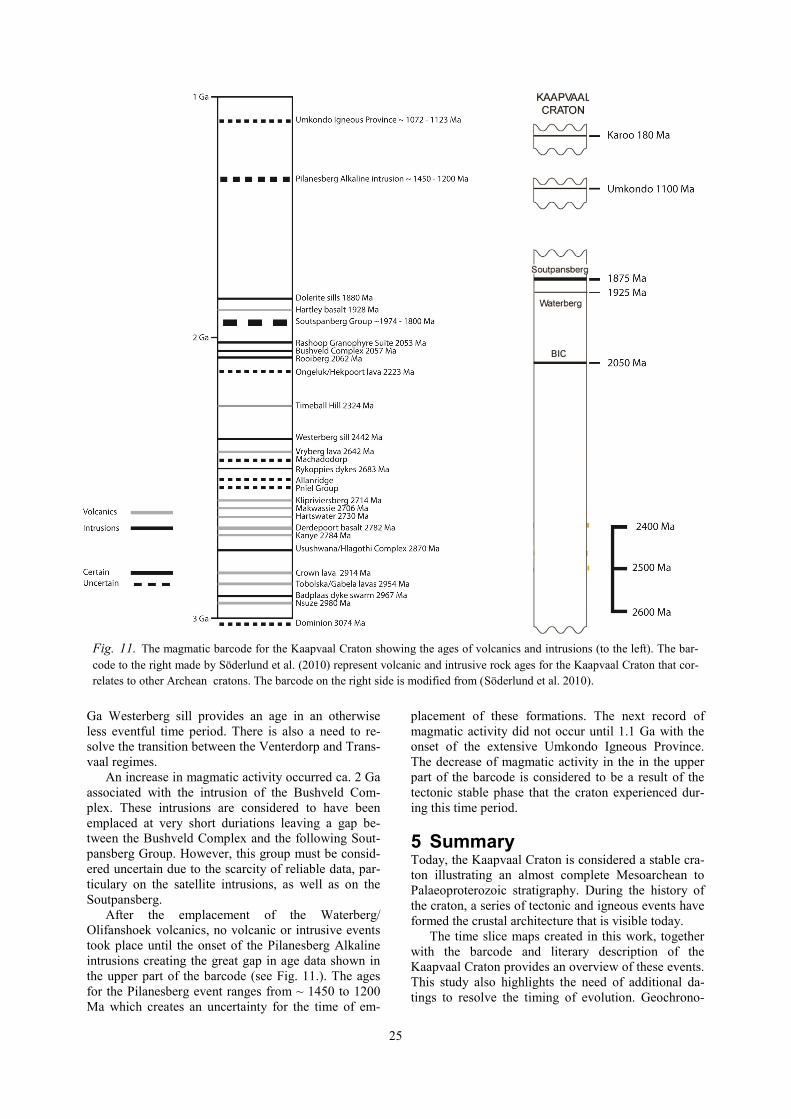
4.7 Kaapvaal Craton barcode The barcode map (Fig. 11.) shows that the Kaapvaal
Craton has undergone periods of more extensive vol-
canism as well as less active periods. Söderlund et al.
(2010) created barcode maps for the Zimbabwe and
Kaapvaal cratons, as well as other Archean cratons.
The correlative ages on the Kaapvaal Craton are rela-
tively sparse, however. As new data emerges a more
detailed barcode can be made.
Most of the intrusions and volcanic events on the
Kaapvaal Craton occurred during the time up until ca.
2.6 Ga, which this older barcode does not illustrate.
Additional correlations might be possible with these
older formations such as a correlation between the
Hlagothi Complex and the Millindinna Complex and
the Zebra Hill dykes on the Pilbara craton in Australia
which is discussed in Gumsley et al. (2013). In addi-
tion, there is now also a correlation to be made at 2.4
Ga. with the Westerberg sill, and also possinly 2.2 Ga,
if the ages of the Ongeluk-Hekpoort are indeed correct
(Gumsley. 2014 pers. comm.)
The Kaapvaal Craton barcode show a period of
extensive magmatic events between ~ 2980 Ma and
2642 Ma after which the activity decreases and the
craton experience greater sedimentation. There are,
however a few events during this period which are
uncertain. The period of the middle to upper Transvaal
has very few dated events with the Ongeluk/Hekpoort
age being uncertain. The new addition of the ca. 2.4
25
Ga Westerberg sill provides an age in an otherwise
less eventful time period. There is also a need to re-
solve the transition between the Venterdorp and Trans-
vaal regimes.
An increase in magmatic activity occurred ca. 2 Ga
associated with the intrusion of the Bushveld Com-
plex. These intrusions are considered to have been
emplaced at very short duriations leaving a gap be-
tween the Bushveld Complex and the following Sout-
pansberg Group. However, this group must be consid-
ered uncertain due to the scarcity of reliable data, par-
ticulary on the satellite intrusions, as well as on the
Soutpansberg.
After the emplacement of the Waterberg/
Olifanshoek volcanics, no volcanic or intrusive events
took place until the onset of the Pilanesberg Alkaline
intrusions creating the great gap in age data shown in
the upper part of the barcode (see Fig. 11.). The ages
for the Pilanesberg event ranges from ~ 1450 to 1200
Ma which creates an uncertainty for the time of em-
placement of these formations. The next record of
magmatic activity did not occur until 1.1 Ga with the
onset of the extensive Umkondo Igneous Province.
The decrease of magmatic activity in the in the upper
part of the barcode is considered to be a result of the
tectonic stable phase that the craton experienced dur-
ing this time period.
5 Summary Today, the Kaapvaal Craton is considered a stable cra-
ton illustrating an almost complete Mesoarchean to
Palaeoproterozoic stratigraphy. During the history of
the craton, a series of tectonic and igneous events have
formed the crustal architecture that is visible today.
The time slice maps created in this work, together
with the barcode and literary description of the
Kaapvaal Craton provides an overview of these events.
This study also highlights the need of additional da-
tings to resolve the timing of evolution. Geochrono-
Fig. 11. The magmatic barcode for the Kaapvaal Craton showing the ages of volcanics and intrusions (to the left). The bar-
code to the right made by Söderlund et al. (2010) represent volcanic and intrusive rock ages for the Kaapvaal Craton that cor-
relates to other Archean cratons. The barcode on the right side is modified from (Söderlund et al. 2010).

26
logic data is essential to understand the relationship
between units at all levels (supergroups, groups and
formations).
The time slice maps give a valuable perspective on
the spatial relationship between different units. Com-
bined with additional geochronologic data this be-
comes a useful tool for further studies and could yield
a more complete understanding of the Kaapvaal Cra-
ton history. A more complete barcode for the Kaapvaal
Craton could yield additional correlations to other cra-
tons such, as the Pilbara Craton in Australia. Such data
can then be used for palaeocontinental reconstruction
and prove the existence of Valbaara.
6 Acknowledgements I want to extend my sincere gratitude to my
supervisors Ashley Gumsley and Ulf Söderlund for
giving essential feedback and comments during this
intense period of work. You have given me an insight
into the exiting area of geochronology, barcoding and
the work that goes into the reconstruction of
palaeocontinents. Special thanks to Ashley for having
the patiens to introduce me to this, for me, relatively
new and uncharted area of geology and for providing
useful tips in the work with ArcGIS.
7 References Altermann, W. & Lenhardt, N., 2012: The volcano-
sedimentary succession of the Archean Sodium
Group, Ventersdorp Supergroup, South Africa;
volcanology, sedimentology and geochemistry.
Precambrian Research 214-215, 60-81.
Armstrong, N. V., Hunter, D. R. & Wilson, A. H.,
1982: Stratigraphy and petrology of the Archaean
Nsuze Group, northern Natal and southeastern
Transvaal, South Africa. Precambrian Research
19, 75-107.
Armstrong, R. A., Compston, W., Retief, E. A., Wil-
liams, I. S. & Welke, H. J., 1991: Zircon ion mi-
croprobe studies bearing on the age and evolution
of the Witwatersrand triad. Precambrian Research
53, 243-266.
Barker, O. B., 1979: A contribution to the geology of
hte Soutpansberg Group, Waterberg Supergroup,
northern Transvaal. M.Cs. thesis (unpubl.), Univ.
Witwatersrand, Johannesburg, , 116.
Barton, J. M., Jr., 1979: The chemical compositions,
Rb-Sr isotopic systematics and tectonic setting of
certain post-kinematic mafic igneous rocks, Lim-
popo mobile belt, southern Africa. Precambrian
Research 9, 57-80.
Beukes, N. J. & Cairncross, B., 1991: A lithostrati-
graphic-sedimentological reference profile for the
late Archaean Mozaan Group, Pongola Sequence;
application to sequence stratigraphy and correla-
tion with the Witwatersrand Supergroup. Verhan-
delinge van die Geologiese Vereniging van Suid
Afrika = Transactions of the Geological Society of
South Africa 94, 44-69.
Bleeker, W., 2003: The late Archean record: A puzzle
in ca. 35 pieces. Lithos 71, 99-134.
Bumby, A. J., Eriksson, P. G., Catuneanu, O., Nelson,
D. R. & Rigby, M. J., 2012: Meso-Archaean and
Palaeo-Proterozoic sedimentary sequence stratigra-
phy of the Kaapvaal Craton. Marine and Petroleum
Geology 33, 92-116.
Burke, K. C., Kidd, W. S. F. & Kusky, T. M., 1985:
The Pongola structure of southeastern Africa; the
world's oldest preserved rift? Journal of Geody-
namics 2, 35-49.
Callaghan, C. C., Eriksson, P. G. & Snyman, C. P.,
1991: The sedimentology of the Waterberg Group
in the Transvaal, South Africa; an overview. Jour-
nal of African Earth Sciences 13, 121-139.
Cawthorn, R. G. & Walraven, F., 1998: Emplacement
and crystallization time for the Bushveld Complex.
Journal of Petrology 39, 1669-1687.
Cawthorn, R. G. & Webb, S. J., 2001: Connectivity
between the western and eastern limbs of the Bush-
veld Complex. Tectonophysics 330, 195-209.
Cheney, E. S., Barton Jr, J. M. & Brandl, G., 1990:
Extent and age of the Soutpansberg sequences of
southern Africa. South African Journal of Geology
93, 664-675.
Coffin, M. F. & Eldholm, O., 1992: Volcanism and
continental break-up; a global compilation of large
igneous provinces. Geological Society Special
Publications 68, 17-30.
Cornell, D. H., Armstrong, R. A. & Walraven, F.,
1998: Geochronology of the Proterozoic Hartley
basalt formation, South Africa; constraints on the
Kheis tectogenesis and the Kaapvaal Craton's earli-
est Wilson cycle. Journal of African Earth Scienc-
es (1994) 26, 5-27.
Cornell, D. H., Schuette, S. S. & Eglington, B. L.,
1996: The Ongeluk basaltic andesite formation in
Griqualand West, South Africa; submarine altera-
tion in a 2222 Ma Proterozoic sea. Precambrian
Research 79, 101-123.
De Kock, M. O., Beukes, N. J. & Armstrong, R. A.,
2012: New SHRIMP U/Pb zircon ages from the
Hartswater Group, South Africa; implications for
correlations of the Neoarchean Ventersdorp Super-
group on the Kaapvaal Craton and with the For-
tescue Group on the Pilbara Craton. Precambrian
Research 204-205, 66-74.
Eales, H. V. & Cawthorn, R. G., 1996: The Bushveld
Complex. Layered intrusions, 181-229.
Eglington, B. M. & Armstrong, R. A., 2004: The
Kaapvaal Craton and adjacent orogens, southern
Africa: A geochronological database and overview
of the geological development of the craton. South
African Journal of Geology 107, 13-32.
Eriksson, P. G., 1994: Early Proterozoic black shales
of the Timeball Hill Formation, South Africa: vol-
canogenic and palaeoenvironmental influences.
Journal of African Earth Sciences 18, 325-337.

27
Eriksson, P. G., Bumby, A. J., Brumer, J. J. & Van
Der Neut, M., 2006: Precambrian fluvial deposits;
enigmatic palaeohydrological data from the c. 2-
1.9 Ga Waterberg Group, South Africa. Sedimen-
tary Geology 190, 25-46.
Eriksson, P. G., Schweitzer, J. K., Bosch, P. J. A.,
Schereiber, U. M., Van Deventer, J. L. & Hatton,
C. J., 1993: The Transvaal Sequence: an overview.
Journal of African Earth Sciences 16, 25-51.
Ernst, R., Bleeker, W., Söderlund, U. & Kerr, A. C.,
2013: Large igneous provinces (LIPs) and super-
continents. Elsevier, Amsterdam, Netherlands.
348 pp.
Bleeker, W., Ernst, R.E., 2006. Short-lived mantle
generated magmatic events and their dyke swarms:
the key to unlocking Earth’s paleogeographic
record back to 2.5 Ga. In: Symposi um Volume for
Fifth International Dyke Conference, July–August
2005. Balkema, Rotter dam.
Gold, D. J. C. & Von Veh, M. W., 1995: Tectonic
evolution of the late Archaean Pongola-Mozaan
Basin, South Africa. Journal of African Earth Sci-
ences 21, 203-212.
Grandstaff, D. E., Edelman, M. J., Foster, R. W., Zbin-
den, E. & Kimberley, M. M., 1986: Chemistry and
mineralogy of Precambrian paleosols at the base of
the Dominion and Pongola Groups (Transvaal,
South Africa). IGCP Project 157 Symposium on
Precambrian Paleopedology, 1-2 June 1985. 2-3
ed. Netherlands. 97-131 pp.
Gumsley, A. P., De Kock, M. O., Rajesh, H. M.,
Knoper, M. W., Soderlund, U. & Ernst, R. E.,
2013: The Hlagothi Complex; the identification of
fragments from a Mesoarchaean large igneous
province on the Kaapvaal Craton. Lithos (Oslo)
174, 333-348.
Guy, B. M., Ono, S., Gutzmer, J., Kaufman, A. J., Lin,
Y., Fogel, M. L. & Beukes, N. J., 2012: A multiple
sulfur and organic carbon isotope record from non-
conglomeratic sedimentary rocks of the Mesoar-
chean Witwatersrand Supergroup, South Africa.
Precambrian Research 216-219, 208-231.
Hatton, C. J. & Schweitzer, J. K., 1995: Evidence for
synchronous extrusive and intrusive Bushveld
magmatism. Journal of African Earth Sciences
(1994) 21, 579-594.
Jackson, M. C., 1992: A review of the late Archaean
volcano-sedimentary Dominion Group and impli-
cations for the tectonic setting of the Witwaters-
rand Supergroup, South Africa. Journal of African
Earth Sciences 15, 169-186.
Johnsson, M. R., Anhaeusser, C. R. & Thomas, R. J.,
2006: The Geology of South Africa. Geological
Society of South Africa.
Kampmann, T. C., 2012: U-Pb geochronology and
paleomagnetism of the Westerberg sill, Kaapvaal
Craton - support of a coherent Kaapvaal-Pilbara
block (Vaalbara). Dissertation in Geology at Lund
University, 32 pp. 45 hp(45 ECTS credits).
Lana, C., Gibson, R. L., Kisters, A. F. M. & Reimold,
W. U., 2003: Archean crustal structure of the
Kaapvaal Craton, South Africa; evidence from the
Vredefort Dome. Earth and Planetary Science Let-
ters 206, 133-144.
Lenhardt, N., Eriksson, P. G., Catuneanu, O. & Bum-
by, A. J., 2012: Nature of and controls on volcan-
ism in the ca. 2.32-2.06 Ga Pretoria Group, Trans-
vaal Supergroup, Kaapvaal Craton, South Africa.
Precambrian Research 214-215, 106-123.
Manzi, M. S. D., Hein, K. a. A., King, N. & Durrheim,
R. J., 2013: Neoarchaean tectonic history of the
Witwatersrand Basin and Ventersdorp Supergroup:
New constraints from high-resolution 3D seismic
reflection data. Tectonophysics 590, 94-105.
Moore, J. M., Polteau, S., Armstrong, R. A., Corfu, F.
& Tsikos, H., 2012: The age and correlation of the
Postmasburg Group, southern Africa: Constraints
from detrital zircon grains. Journal of African
Earth Sciences 64, 9-19.
Moore, J. M., Tsikos, H. & Polteau, S., 2001: Decon-
structing the Transvaal Supergroup, South Africa;
implications for Palaeoproterozoic palaeoclimate
models. Journal of African Earth Sciences (1994)
33, 437-444.
Mukasa, S. B., Wilson, A. H. & Young, K. R., 2013:
Geochronological constraints on the magmatic and
tectonic development of the Pongola Supergroup
(central region), South Africa. Precambrian Re-
search 224, 268-286.
Nelson, D. R., Trendall, A. F. & Altermann, W., 1999:
Chronological correlations between the Pilbara and
Kaapvaal cratons. Precambrian Research 97, 165-
189.
Niekerk, C. B. V. & Burger, A. J., 1969: Lead isotopic
data relating to the age of the Dominion Reef lava.
Verhandelinge van die Geologiese Vereniging van
Suid Afrika = Transactions of the Geological Soci-
ety of South Africa 72, Part 2, 37-45.
Oberholzer, J. D. & Eriksson, P. G., 2000: Subaerial
volcanism in the Palaeoproterozoic Hekpoort For-
mation (Transvaal Supergroup), Kaapvaal Craton.
Precambrian Research 101, 193-210.
Olsson, J. R., Soderlund, U., Klausen, M. B. & Ernst,
R. E., 2010: U/Pb baddeleyite ages linking major
Archean dyke swarms to volcanic rift forming
events in the Kaapvaal Craton (South Africa), and
a precise age for the Bushveld Complex. Precam-
brian Research 183, 490-500.
Olsson. J. R., 2012: U-Pb baddeleyite geochronology
of Precambrian mafic dyke swarms and complexes
of southern Africa– regional extensional events
and the origin of the Bushveld Complex. Doctoral
Dissertation. Department of Geology Lund Univer-
sity. 12 pp.
Reimold, W. U., Pybus, G. Q. J., Kruger, F. J., Layer,
P. W. & Koeberl, C., 2000: The Anna's Rust Sheet
and related gabbroic intrusions in the Vredefort
Dome-Kibaran magmatic event on the Kaapvaal
Craton and beyond? Journal of African Earth Sci-
ences (1994) 31, 499-521.

28
Schmitz, M. D., Bowring, S. A., De Wit, M. J. &
Gartz, V., 2004: Subduction and terrane collision
stabilize the western Kaapvaal craton tectosphere
2.9 billion years ago. Earth and Planetary Science
Letters 222, 363-376.
Schweitzer, J. K., Hatton, C. J. & De Waal, S. A.,
1997: Link between the granitic and volcanic rocks
of the Bushveld Complex, South Africa. Journal of
African Earth Sciences (1994) 24, 95-104.
Soderlund, U., Hofmann, A., Klausen, M. B., Olsson,
J. R., Ernst, R. E. & Persson, P.-O., 2010: Towards
a complete magmatic barcode for the Zimbabwe
Craton; baddeleyite U/Pb dating of regional doler-
ite dyke swarms and sill complexes. Precambrian
Research 183, 388-398.
Strik, G., De Wit, M. J. & Langereis, C. G., 2007: Pal-
aeomagnetism of the Neoarchaean Pongola and
Ventersdorp supergroups and an appraisal of the
3.0-1.9 Ga apparent polar wander path of the
Kaapvaal Craton, Southern Africa. Precambrian
Research 153, 96-115.
Söderlund, U., Ibanez-Mejia, M., El Bahat, A., Ernst,
R. E., Ikenne, M., Soulaimani, A., Youbi, N.,
Cousens, B., El Janati, M. H. & Hafid, A., 2013:
Reply to Comment on “U–Pb baddeleyite ages and
geochemistry of dolerite dykes in the Bas-Drâa
inlier of the Anti-Atlas of Morocco: Newly
identified 1380 Ma event in the West
African Craton” by André Michard and Dominique
Gasquet. Lithos 174, 101-108.
Twist, D. & French, B. M., 1983: Voluminous acid
volcanism in the Bushveld Complex; a review of
the Rooiberg Felsite. Bulletin Volcanologique 46,
225-242.
Van Der Westhuizen, W. A., De Bruiyn, H. & Meint-
jes, P. G., 1991: The Ventersdorp Supergroup: an
overview. Journal of African Earth Sciences 13,
83-105.
Wingate, M. T. D., 1998: A palaeomagnetic test of the
Kaapvaal - Pilbara (Vaalbara) connection at 2.78
Ga. South African Journal of Geology 101, 257-
274.
Von Gruenewaldt, G., Coertze, F. J., Du Plessis, M.
D., Ferguson, J., Hunter, D. R., Lenthall, D. H.,
Vermaak, C. F., Lee, C. & Walraven, F., 1980:
Bushveld Complex. In: L. E. Kent (ed.) Stratigra-
phy of South Africa; Handbook 8; Part 1,
Lithostratigraphy of the Republic of South Africa,
South West Africa/Namibia and the republics of
Bophuthatswana, Transkei and Venda. South Afri-
ca Geological Survey, Department of Mineral and
Energy Affairs, Pretoria, South Africa. 223-241 pp.

Tidigare skrifter i serien
”Examensarbeten i Geologi vid Lunds
universitet”:
334. Fullerton, Wayne, 2013: The Kalgoorlie
Gold: A review of factors of formation
for a giant gold deposit. (15 hp)
335. Hansson, Anton, 2013: A dendroclimatic
study at Store Mosse, South Sweden –
climatic and hydrologic impacts on recent
Scots Pine (Pinus sylvestris) growth dy-
namics. (45 hp)
336. Nilsson, Lawrence, 2013: The alteration
mineralogy of Svartliden, Sweden. (30
hp)
337. Bou-Rabee, Donna, 2013: Investigations
of a stalactite from Al Hota cave in Oman
and its implications for palaeoclimatic
reconstructions. (45 hp)
338. Florén, Sara, 2013: Geologisk guide till
Söderåsen – 17 geologiskt intressanta
platser att besöka. (15 hp)
339. Kullberg, Sara, 2013:
Asbestkontamination av dricksvatten och
associerade risker. (15 hp)
340. Kihlén, Robin, 2013: Geofysiska
resistivitets-mätingar i Sjöcrona Park,
Helsingborg, under-sökning av områdets
geologiska egenskaper samt 3D
modellering i GeoScene3D. (15 hp)
341. Linders, Wictor, 2013: Geofysiska IP-
under-sökningar och 3D-modellering av
geofysiska samt geotekniska resultat i
GeoScene3D, Sjöcrona Park,
Helsingborg, Sverige. (15 hp)
342. Sidenmark, Jessica, 2013: A reconnais-
sance study of Rävliden VHMS-deposit,
northern Sweden. (15 hp)
343. Adamsson, Linda, 2013: Peat stratigraph-
ical study of hydrological conditions at
Stass Mosse, southern Sweden, and the
relation to Holocene bog-pine growth. (45
hp)
344. Gunterberg, Linnéa, 2013: Oil occurrenc-
es in crystalline basement rocks, southern
Norway – comparison with deeply weath-
ered basement rocks in southern Sweden.
(15 hp)
345. Peterffy, Olof, 2013: Evidence of epiben-
thic microbial mats in Early Jurassic
(Sinemurian) tidal deposits, Kulla Gun-
narstorp, southern Sweden. (15 hp)
346. Sigeman, Hanna, 2013: Early life and its
implications for astrobiology – a case
study from Bitter Springs Chert, Australia.
(15 hp)
347. Glommé, Alexandra, 2013: Texturella
studier och analyser av
baddeleyitomvandlingar i zirkon, exempel
från sydöstra Ghana. (15 hp)
348. Brådenmark, Niklas, 2013: Alunskiffer på
Öland – stratigrafi, utbredning,
mäktigheter samt kemiska och fysikaliska
egenskaper. (15 hp)
349. Jalnefur Andersson, Evelina, 2013: En
MIFO fas 1-inventering av fyra potentiellt
förorenade områden i Jönköpings län. (15
hp)
350. Eklöv Pettersson, Anna, 2013: Monazit i
Obbhult-komplexet: en pilotstudie. (15
hp)
351. Acevedo Suez, Fernando, 2013: The relia-
bility of the first generation infrared re-
fractometers. (15 hp)
352. Murase, Takemi, 2013: Närkes alunskiffer
– utbredning, beskaffenhet och
oljeinnehåll. (15 hp)
353. Sjöstedt, Tony, 2013: Geoenergi –
utvärdering baserad på ekonomiska och
drifttekniska resultat av ett passivt
geoenergisystem med värmeuttag ur berg i
bostadsrättsföreningen Mandolinen i
Lund. (15 hp)
354. Sigfúsdóttir, Thorbjörg, 2013: A sedimen-
tological and stratigraphical study of
Veiki moraine in northernmost Sweden.
(45 hp)
355. Månsson, Anna, 2013: Hydrogeologisk
kartering av Hultan, Sjöbo kommun. (15
hp)
356. Larsson, Emilie, 2013: Identifying the
Cretaceous–Paleogene boundary in North
Dakota, USA, using portable XRF. (15
hp)
357. Anagnostakis, Stavros, 2013: Upper Cre-
taceous coprolites from the Münster Basin
(northwestern Germany) – a glimpse into
the diet of extinct animals. (45 hp)
358. Olsson, Andreas, 2013: Monazite in
metasediments from Stensjöstrand: A pi-
lot study. (15 hp)
359. Westman, Malin, 2013: Betydelsen av
raka borrhål för större geoenergisystem.
(15 hp)
360. Åkesson, Christine, 2013: Pollen analyti-
cal and landscape reconstruction study at
Lake Storsjön, southern Sweden, over the
last 2000 years. (45 hp)
361. Andolfsson, Thomas, 2013: Analyses of
thermal conductivity from mineral com-

position and analyses by use of Thermal
Conductivity Scanner: A study of thermal
properties in Scanian rock types. (45 hp)
362. Engström, Simon, 2013: Vad kan
inneslutningar i zirkon berätta om
Varbergscharnockiten, SV Sverige. (15
hp)
363. Jönsson, Ellen, 2013: Bevarat
maginnehåll hos mosasaurier. (15 hp)
364. Cederberg, Julia, 2013: U-Pb baddeleyite
dating of the Pará de Minas dyke swarm
in the São Francisco craton (Brazil) -
three generations in a single swarm. (45
hp)
365. Björk, Andreas, 2013: Mineralogisk och
malmpetrografisk studie av disseminerade
sulfider i rika och fattiga prover från
Kleva. (15 hp)
366. Karlsson, Michelle, 2013: En MIFO fas 1
-inventering av förorenade områden:
Kvarnar med kvicksilverbetning
Jönköpings län. (15 hp)
367. Michalchuk, Stephen P., 2013: The Säm
fold structure: characterization of folding
and metamorphism in a part of the eclo-
gite-granulite region, Sveconorwegian
orogen. (45 hp)
368. Praszkier, Aron, 2013: First evidence of
Late Cretaceous decapod crustaceans
from Åsen, southern Sweden. (15 hp)
369. Alexson, Johanna, 2013: Artificial
groundwater recharge – is it possible in
Mozambique? (15 hp)
370. Ehlorsson, Ludvig, 2013: Hydrogeologisk
kartering av grundvattenmagasinet
Åsumsfältet, Sjöbo. (15 hp)
371. Santsalo, Liina, 2013: The Jurassic
extinction events and its relation to CO2
levels in the atmosphere: a case study on
Early Jurassic fossil leaves. (15 hp)
372. Svantesson, Fredrik, 2013: Alunskiffern i
Östergötland – utbredning, mäktigheter,
stratigrafi och egenskaper. (15 hp)
373. Iqbal, Faisal Javed, 2013: Paleoecology
and sedimentology of the Upper Creta-
ceous (Campanian), marine strata at
Åsen, Kristianstad Basin, Southern Swe-
den, Scania. (45 hp)
374. Kristinsdóttir, Bára Dröfn, 2013: U-Pb, O
and Lu-Hf isotope ratios of detrital zircon
from Ghana, West-African Craton – For-
mation of juvenile, Palaeoproterozoic
crust. (45 hp)
375. Grenholm, Mikael, 2014: The Birimian
event in the Baoulé Mossi domain (West
African Craton) — regional and global
context. (45 hp)
376. Hafnadóttir, Marín Ósk, 2014: Under-
standing igneous processes through zircon
trace element systematics: prospects and
pitfalls. (45 hp)
377. Jönsson, Cecilia A. M., 2014: Geophysi-
cal ground surveys of the Matchless Am-
phibolite Belt in Namibia. (45 hp)
378. Åkesson, Sofia, 2014: Skjutbanors
påverkan på mark och miljö. (15 hp)
379. Härling, Jesper, 2014: Food partitioning
and dietary habits of mosasaurs (Reptilia,
Mosasauridae) from the Campanian
(Upper Cretaceous) of the Kristianstad
Basin, southern Sweden. (45 hp)
380. Kristensson, Johan, 2014: Ordovicium i
Fågelsångskärnan-2, Skåne – stratigrafi
och faciesvariationer. (15 hp) 381. Höglund, Ida, 2014: Hiatus - Sveriges
första sällskapsspel i sedimentologi. (15
hp)
382. Malmer, Edit, 2014: Vulkanism - en fara
för vår hälsa? (15 hp)
383. Stamsnijder, Joaen, 2014: Bestämning av
kvartshalt i sandprov - medtodutveckling
med OSL-, SEM– och EDS-analys. (15
hp)
384. Helmfrid, Annelie, 2014: Konceptuell
modell över spridningsvägar för
glasbruksföroreningar i Rejmyre
samhälle. (15 hp)
385. Adolfsson, Max, 2014: Visualizing the
volcanic history of the Kaapvaal Craton
using ArcGIS. (15 hp)
Geologiska institutionen
Lunds universitet
Sölvegatan 12, 223 62 Lund