Embed Size (px)
Citation preview
ES022007003SCO/LW2459.DOC/070400007
Final Schuyler Heim Bridge Replacement and
SR-47 Expressway Project
Visual Impact Assessment
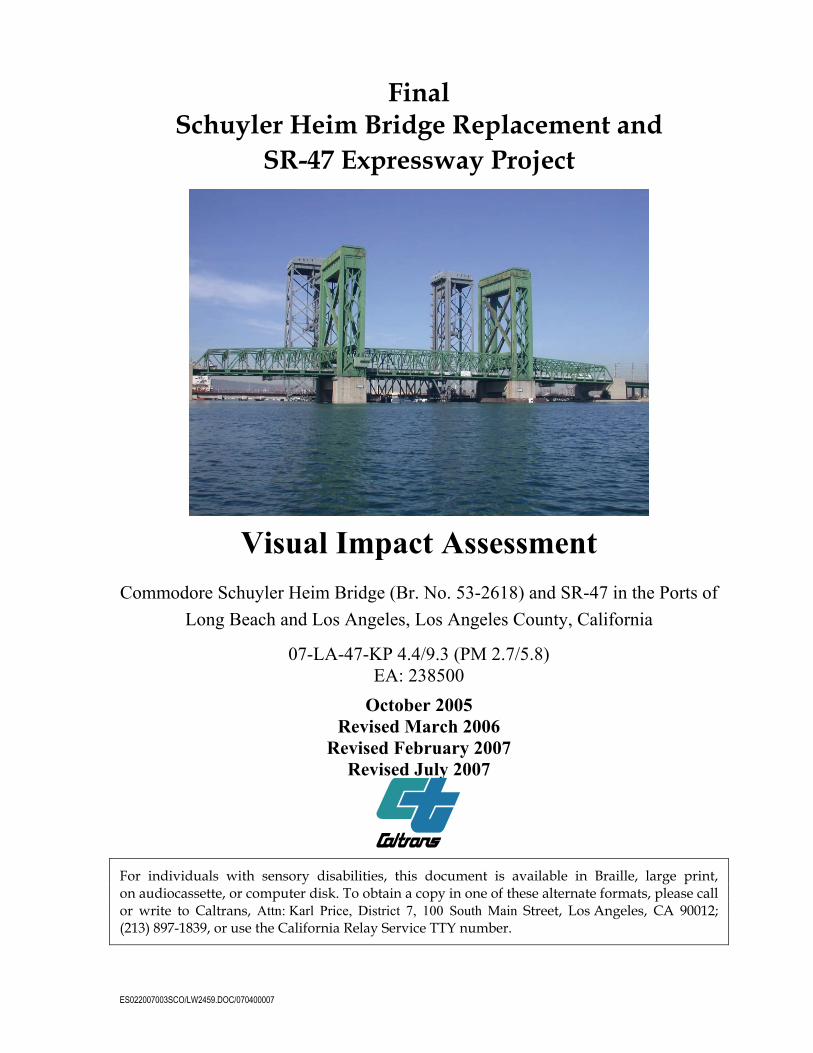
Commodore Schuyler Heim Bridge (Br. No. 53-2618) and SR-47 in the Ports of Long Beach and Los Angeles, Los Angeles County, California
07-LA-47-KP 4.4/9.3 (PM 2.7/5.8) EA: 238500
October 2005 Revised March 2006
Revised February 2007 Revised July 2007
For individuals with sensory disabilities, this document is available in Braille, large print, on audiocassette, or computer disk. To obtain a copy in one of these alternate formats, please call or write to Caltrans, Attn: Karl Price, District 7, 100 South Main Street, Los Angeles, CA 90012; (213) 897-1839, or use the California Relay Service TTY number.

ES022007003SCO/LW2459.DOC/070400007
Final Visual Impact Assessment
Schuyler Heim Bridge Replacement and SR-47 Expressway Project
Commodore Schuyler Heim Bridge (Br. No. 53-2618) and SR-47 in the Ports of
Long Beach and Los Angeles, Los Angeles County, California
07-LA-47-KP 4.4/9.3 (PM 2.7/5.8)
EA: 238500
October 2005 Revised March 2006
Revised February 2007 Revised July 2007
This Visual Impact Assessment has been prepared under the direction of the following environmental professionals. The environmental professionals attest to the technical information contained herein and the data upon which recommendations, conclusions, and decisions are based.
Prepared By: ___________________________________ Date: July 23, 2007 Elizabeth Cutler 714/429-2000 CH2M HILL 3 Hutton Centre Drive, Suite 200 Santa Ana, CA 92707
Task Manager: __________________________________ Date: July 23, 2007 Tom Priestley 510/587-7653 CH2M HILL 155 Grand Avenue, Suite 1000 Oakland, CA 94612


ES022007003SCO/LW2459.DOC/070400007
March 31, 2006
March 31, 2006
Final Visual Impact Assessment
Schuyler Heim Bridge Replacement and SR-47 Expressway Project
Commodore Schuyler Heim Bridge (Br. No. 53-2618) and SR-47
Port of Long Beach and Los Angeles Los Angeles County, California
07-LA-47-4.5/8.5 (2.8/5.3)
EA: 23850K
October 2005 Revised March 2006
This Visual Impact Assessment has been prepared under the direction of the following environmental professionals. The environmental professionals attest to the technical information contained herein and the data upon which recommendations, conclusions, and decisions are based.
Prepared By: ___________________________________ Date: _________________ Elizabeth Cutler 714/435-6370 CH2M HILL 3 Hutton Centre Drive, Suite 200 Santa Ana, CA 92707
Task Manager: __________________________________ Date: _________________ Tom Priestley 510/587-7653 CH2M HILL 155 Grand Avenue, Suite 1000 Oakland, CA 94612


ES022007003SCO/LW2459.DOC/070400007 I
Contents
Section Page
1.0 Introduction....................................................................................................................... 1-1 1.1 Purpose of Report...................................................................................................... 1-1 1.2 Purpose and Need for Project.................................................................................. 1-1
1.2.1 Schuyler Heim Bridge.................................................................................. 1-1 1.3 Proposed Project Alternatives ................................................................................. 1-2
1.3.1 Alternative 1: Bridge Replacement and Expressway .............................. 1-2 1.3.2 Alternative 1A: Haunch Bridge Design .................................................... 1-3 1.3.3 Alternative 2: SR-103 Extension to Alameda Street................................. 1-4 1.3.4 Alternative 3: Bridge Avoidance................................................................ 1-4 1.3.5 Alternative 4: Bridge Replacement Only .................................................. 1-4 1.3.6 Alternative 5: Transportation System Management ............................... 1-5 1.3.7 Alternative 6: No Build................................................................................ 1-5
1.4 Aesthetic Minimization Measures .......................................................................... 1-6 2.0 Regulatory Setting............................................................................................................ 2-1
2.1 Federal Requirements ............................................................................................... 2-1 2.2 State Requirements.................................................................................................... 2-1 2.3 Regional and Local Requirements .......................................................................... 2-1
2.3.1 Port of Los Angeles Master Plan ................................................................ 2-1 2.3.2 City of Los Angeles General Plan .............................................................. 2-1 2.3.3 Wilmington-Harbor City Community Plan ............................................. 2-2 2.3.4 Port of Long Beach Master Plan ................................................................. 2-3 2.3.5 City of Long Beach Municipal Code and General Plan .......................... 2-3 2.3.6 City of Carson General Plan ....................................................................... 2-4
3.0 Affected Environment ..................................................................................................... 3-1 3.1 Study Methods and Procedures .............................................................................. 3-1 3.2 Existing Visual Environment................................................................................... 3-1
3.2.1 Regional Landscape ..................................................................................... 3-1 3.2.2 Landscape Units ........................................................................................... 3-2 3.2.3 Project Viewshed.......................................................................................... 3-4
3.3 Existing Visual Resources and Viewer Response ................................................. 3-5 3.3.1 FHWA Method of Visual Resource Analysis ........................................... 3-5 3.3.2 Existing Visual Resources ........................................................................... 3-5 3.3.3 Methods of Predicting Viewer Response.................................................. 3-8 3.3.4 Existing Viewer Sensitivity ......................................................................... 3-8 3.3.5 Existing Viewer Groups, Viewer Exposure, and Viewer Awareness....3-10
4.0 Environmental Consequences........................................................................................ 4-1 4.1 Permanent Impacts ................................................................................................... 4-1
4.1.1 Method of Assessing Project Impacts........................................................ 4-1 4.1.2 Definition of Visual Impact Levels ............................................................ 4-1

CONTENTS
II ES022007003SCO/LW2459.DOC/070400007
4.1.3 Analysis of Key Views .................................................................................4-1 4.2 Temporary Impacts .................................................................................................4-31
5.0 Avoidance, Minimization, and/or Mitigation Measures...........................................5-1 6.0 Cumulative Impacts..........................................................................................................6-1 7.0 CEQA Evaluation..............................................................................................................7-1
7.1 Evaluation Criteria.....................................................................................................7-1 7.1.1 Project and Alternatives Environmental Impacts and Mitigation .........7-1
8.0 Summary of Agency/Public Consultation and Coordination ..................................8-1 9.0 Mitigation and Monitoring Commitments ..................................................................9-1 10.0 List of Preparers...............................................................................................................10-1 11.0 References ........................................................................................................................11-1
Appendixes A Glossary of Technical Terms
B Visual Quality Evaluation
B1 Visual Quality Rating Forms Existing Conditions and With Project B2 Visual Quality Evaluation – Change by Key Observation Point B3 Visual Quality Evaluation – Change by Alternative
C Figures
1 Location Map, Alternatives, Landscape Units, and Key Viewpoints 2 Key View 1a (Gerald Desmond Bridge) – Fixed-Span Bridge 3 Key View 1a (Gerald Desmond Bridge) – Fixed-Span Bridge (Haunch Design) 4 Key View 1b (Gerald Desmond Bridge) – Flyover 5 Key View 2 (Eastbound Ocean Boulevard) – Flyover 6 Key View 3 (Anchorage Way Marinas) – Fixed-Span Bridge 7 Key View 3 (Anchorage Way Marinas) – Fixed-Span Bridge (Haunch Design) 8 Key View 4 (Leeward Bay Marina) – Elevated Expressway 9a Key View 5 (Young Street) – Elevated Expressway 9a Key View 5 (Young Street) – Elevated Expressway 10 Key View 6 (Hudson Elementary School) – SR-103 Extension 11 Key View 7 (Alameda Street South of I-405) – SR-103 Extension
D Cumulative Projects
Tables 1 Potential Aesthetic Minimization Measures – By Alternative...................................... 1-6 2 Summary of Impacts (CEQA) During Construction and Operation to Visual
Resources by Evaluation Criteria and Alternative......................................................... 8-2

ES022007003SCO/LW2459.DOC/070400007 III
Acronyms
Caltrans California Department of Transportation
CEQA California Environmental Quality Act
EIS/EIR environmental impact statement/environmental impact report
FHWA Federal Highway Administration
HE(C) Caltrans Highway Easement
I Interstate
ICTF Intermodal Container Transfer Facility
IP Industrial Zone
ITS Intelligent Transportation System
km kilometer
LCP Local Coastal Program
m meter
MHWL mean high water level
mi mile(s)
NEPA National Environmental Policy Act
POLA Port of Los Angeles
POLB Port of Long Beach
ROW right-of-way
SCE Southern California Edison
Schuyler Heim Bridge Commodore Schuyler F. Heim Bridge
SR State Route
TSM transportation system management
U.S.C. U.S. Code


ES022007003SCO/LW2459.DOC/070400007 1-1
1.0 Introduction
1.1 Purpose of Report The purpose of this technical study is to assess the visual impacts of the Schuyler Heim Bridge Replacement and SR-47 Expressway Project alternatives and to propose measures to mitigate any associated adverse or significant impacts on the visual environment. All figures are in Appendix C.
1.2 Purpose and Need for Project
1.2.1 Schuyler Heim Bridge The purpose of the FHWA/Caltrans portion of the proposed project is to:
• Provide a structurally and seismically safe vehicular connection along the critical north-south corridor between Terminal Island and the mainland that can remain in service following a major earthquake to ensure that ground and vessel transportation are maintained
• Improve operational and safety design features of the crossing to facilitate the movement of people, freight, and goods, while meeting current design standards to the maximum extent feasible
The purpose of ACTA portion of the proposed project is to provide a high-capacity alternative route for traffic between Terminal Island and I-405 that would:
• Reduce traffic congestion on local surface streets (between Terminal Island and Pacific Coast Highway), as well as on I-110 and I-710
• Improve safety by providing a limited-access route between Terminal Island and I-405 that would:
• Eliminate at-grade railroad crossings and signalized intersections
• Connect the Schuyler Heim Bridge with an emergency service structure that would facilitate movement to and from the ports following a major earthquake
This high-capacity link would allow traffic to continue northward along Alameda Street, or SR-103, and provide essential north-south connectivity with the regional freeway system (I-405 and SR-91) for the movement of people and goods to and from the ports.
The need for the Schuyler Heim Bridge improvements includes the following deficiencies of the bridge and area transportation requirements:
• Schuyler Heim Bridge − Seismic Deficiency − Structural Deficiency

1.0 INTRODUCTION
1-2 ES022007003SCO/LW2459.DOC/070400007
− Operational and Safety Design Standards − Delays to the Movement of People, Freight, and Goods − Extend Bridge Life Cycle
• High-Capacity Route − Insufficient Freeway Capacity − Local Surface Street Congestion − Safety at Intersections and Railroad Crossings − Inability to Provide for Uninterrupted Transport of People, Freight, and Goods
Following a Major Earthquake
1.3 Proposed Project Alternatives The proposed action is to improve traffic conditions between Terminal Island, which is located within the Ports of Long Beach and Los Angeles, and major traffic arterials on the mainland to the north, primarily within the cities of Long Beach and Los Angeles. Six alternatives have been proposed for analysis in an Environmental Impact Statement/ Environmental Impact Report (EIS/EIR) to address the proposed action. Collectively, these alternatives are considered the proposed project. There are four build alternatives, one transportation system management (TSM) alternative, and one no-build alternative. These alternatives are described below. The four build alternatives are shown in Figure 1.
1.3.1 Alternative 1: Bridge Replacement and Expressway This alternative would replace the existing Commodore Schuyler F. Heim Bridge (Schuyler Heim Bridge) to meet current seismic criteria and provide an elevated through-lane (Ocean Boulevard/SR-47 Flyover [flyover]) from eastbound Ocean Boulevard onto northbound SR-47. It also would construct a new SR-47 expressway to provide a high-capacity alternative route along the Alameda Corridor for traffic between Terminal Island and Alameda Street, south of Pacific Coast Highway. The Schuyler Heim Bridge is a major traffic route and connects Terminal Island within the Ports of Long Beach and Los Angeles to the mainland Cities of Long Beach and Los Angeles. The bridge is located within the City of Los Angeles and through property owned by the Port of Long Beach.
With this alternative, a new fixed-span bridge would be constructed primarily within the existing bridge right-of-way (ROW) (Caltrans Highway Easement [HE(C)]), but toward the east to avoid impacts to the railroad on the Badger Avenue Bridge immediately to the west; the existing Schuyler Heim Bridge (lift bridge) would be demolished. The replacement bridge would be slightly wider (13 meters [m] [43 feet (ft)]) than the existing bridge due to the addition of standard shoulders, which are not present on the existing bridge. The replacement bridge would include three 3.6-m (12-ft) lanes (two through-lanes and one auxiliary lane), and 3-m (10-ft) shoulders in the northbound direction, and four 3.6-m (12-ft) lanes (three through-lanes and one auxiliary lane),, and 3-m (10-ft) shoulders in the southbound direction. Bridge construction would include a southbound off-ramp and northbound on-ramp at New Dock Street on Terminal Island, as well as a northbound off-ramp and southbound on-ramp at Henry Ford Avenue on the mainland side of the bridge. With this alternative, the new bridge would be supported by four piers in the channel, with a minimum vertical clearance of 14.3 m (47 ft) over the mean high water level

1.0 INTRODUCTION
ES022007003SCO/LW2459.DOC/070400007 1-3
(MHWL). This clearance would be maintained for the width of the navigable channel, which would be 54.9 m (180 ft).
The Ocean Boulevard/SR-47 flyover will be a two-lane, elevated structure to divert traffic bound for northbound SR-47 directly onto the new bridge from eastbound Ocean Boulevard. The purpose of the flyover is to enable this traffic to avoid the signalized Ocean Boulevard/SR-47 intersection. Under Alternative 1, the flyover will begin on Terminal Island, about 1,200 m (3,900 ft) west of the Ocean Boulevard/SR-47 intersection, extend eastward along the south side of Ocean Boulevard, then turn north, cross over Ocean Boulevard and onto the new bridge. The west end of the flyover will be at grade, then rise to a maximum elevation of 21 m (69 ft) to cross over Ocean Boulevard, then descend to an elevation of 12.9 m (42.4 ft) to join the new bridge. The elevated portions of the flyover will be supported by 8 single-column bents and 2 two-column outrigger bents. Each column is approximately 2.4 m (8 ft) in diameter. The structure will consist of 11 spans, with lengths that range between 57 m (186 ft) and 73 m (240 ft). The flyover will have an overall length of 1,550 m (5,084 ft), ending at the northerly end point (gore point) of the northbound New Dock Street on-ramp onto the bridge. The left lane of the flyover will converge with the SR-47 through-lane to the left; the right lane of the flyover will continue as a northbound SR-47 through-lane and will have the option to continue to SR-47 or SR-103. The flyover will be located entirely within the City and Port of Long Beach.
The new SR-47 Expressway would begin on Terminal Island, at the intersection of SR-47 and Ocean Boulevard, extending north over New Dock Street and onto the Schuyler Heim Bridge replacement. A new northbound on-ramp would be constructed from New Dock Street, and a new southbound off-ramp would be constructed to New Dock Street, as described above. The expressway would extend northward to Alameda Street, south of the intersection with Pacific Coast Highway, a distance of approximately 2.7 kilometers (km) (1.5 miles [mi]). The expressway would be a four-lane, limited access roadway. It would grade-separate five at-grade railroad crossings and three signalized intersections along its length. A segment of the expressway would be constructed as an elevated viaduct over Henry Ford Avenue and Alameda Street and return to grade at Alameda Street, just south of Pacific Coast Highway. Under this alternative, connectivity to SR-103 would be maintained. This alternative includes improvements to the Alameda Street/Wardlow Road connector and to Alameda Street north and south of the connector.
1.3.2 Alternative 1A: Haunch Bridge Design Alternative 1A is a structural variation of Alternative 1. The main purpose of this alternative is to improve the aesthetics of the replacement bridge over the Cerritos Channel and span a greater horizontal distance across the channel between columns. This is accomplished by increasing the span lengths over the channel and arching the superstructure soffits (the bottom of the bridge structure). Under this alternative, the new bridge would be supported by two piers (four columns) in the Cerritos Channel, compared to four piers (eight columns) under Alternative 1; and the minimum vertical clearance between the piers would be of 14.3 m (47 feet). This clearance would be maintained for the width of the navigable channel, which would be 54.9 m (180 feet).
Other aspects of this alternative, including the flyover, would be the same as Alternative 1.

1.0 INTRODUCTION
1-4 ES022007003SCO/LW2459.DOC/070400007
1.3.3 Alternative 2: SR-103 Extension to Alameda Street With this alternative, the existing Schuyler Heim Bridge would be demolished; and a new fixed-span bridge and flyover would be constructed, as described under Alternative 1. With this alternative, the right lane of the flyover would continue to SR-103 after crossing the new bridge. Additionally, modifications to the northbound and southbound approaches to the bridge would be constructed.
This alternative also would extend SR-103 to the northwest on a four-lane elevated viaduct to join Alameda Street between Sepulveda Boulevard and I-405. Improvements to SR-103 would begin approximately 3.2 km (2 mi) north of the Schuyler Heim Bridge and extend a distance of approximately 2.6 km (1.6 mi). The elevated viaduct would cross over the Union Pacific Railroad manual yard and San Pedro Branch, through the Southern California Edison (SCE) utility corridor, across the Los Angeles Harbor Department Warehouse 16/17 area, over Sepulveda Boulevard, then parallel the western boundary of the Intermodal Container Transfer Facility (ICTF) to the centerline of Alameda Street. The viaduct would slope to grade south of the Wardlow Road ramps to I-405. Improvements would be made to the existing SR-103 to accommodate the southerly end connection of the viaduct and to SR-47 to accommodate the northerly end connection of the viaduct. This alternative also includes widening the Alameda Street/Wardlow Road connector and improvements to Alameda Street north and south of the connector.
1.3.4 Alternative 3: Bridge Avoidance This alternative would preserve the existing Schuyler Heim Bridge and construct a new fixed-span bridge on an alignment east of the existing bridge, and construct the flyover as described for Alternative 1. Under this alternative, the new bridge would have the same lane configuration as the replacement bridge for Alternative 1.
This alternative includes seismic retrofit of the existing Schuyler Heim Bridge, which would remain standing but unused. The retrofit would be for safety purposes, to avoid demolition of a historic resource, and to ensure that the existing bridge would not collapse and result in safety hazards or damage to the new bridge or to the adjacent Badger Avenue Bridge. However, according to the U.S. Coast Guard, when a bridge is no longer used for its permitted purpose of providing land transportation, the bridge shall be removed from the waterway. Therefore, removal of the existing Schuyler Heim Bridge would be included as a condition of the federal permit for the replacement bridge.
With this alternative, a new SR-47 Expressway would be constructed north of the new fixed-span bridge, as described under Alternative 1, and connectivity with SR-103 would be maintained. Improvements to Alameda Street and the Wardlow Road connector would be the same as described under Alternative 1.
1.3.5 Alternative 4: Bridge Replacement Only This alternative would replace the existing Schuyler Heim Bridge (lift bridge) with a fixed-span bridge largely along the existing bridge alignment, and the existing Schuyler Heim Bridge would be demolished, as would occur under Alternative 1.

1.0 INTRODUCTION
ES022007003SCO/LW2459.DOC/070400007 1-5
With this alternative, no roadway improvements would occur. With this alternative, therefore, the SR-47 Expressway described in Alternative 1 would not be constructed; and the SR-103 extension to Alameda Street described in Alternative 2 would not be constructed. This alternative also does not include the flyover.
1.3.6 Alternative 5: Transportation System Management This alternative is designed to identify low-cost, easily implementable improvements as an alternative to construction of more expensive improvements. For this project, the TSM alternative focuses on improvements to routes that parallel the proposed SR-47 Expressway, and that serve the same trips. These trips include trucking drayage trips to and from the ICTF, and trips destined to and from the Ports via Alameda Street, Henry Ford Avenue, and SR-47. The TSM alternative would include measures to improve capacity and traffic circulation at the Port of Long Beach and Port of Los Angeles through policy changes and use of the latest technologies. With this alternative, capital investment would be minimal compared to the previous alternatives addressed.
The TSM alternative for this project includes the following key elements:
• Intelligent Transportation Systems (ITS): Systems applications in and around the Port area, with special emphasis on truck movements. These include measures to improve traffic circulation through traffic control, incident management, traffic surveillance, and traffic information dissemination with the aid of intelligent transportation system devices and systems.
• Lower-cost roadway and intersection improvements: Measures include restriping to provide additional turn lanes and acceleration lanes and traffic signalization improvements, primarily within existing rights-of-way.
• Minor roadway widening: There also could be peak-hour parking prohibitions to remove midblock bottlenecks along selected roadways.
This alternative would not result in the increased ability of the Schuyler Heim Bridge to withstand a major earthquake In the event of a major earthquake that would render the Schuyler Heim Bridge unusable, there are only two other access routes to and from Terminal Island. In the event of a major earthquake that would render the bridge unusable, a TSM alternative would not be effective in reducing roadway demand or in redirecting Terminal Island traffic to other routes.
This alternative would not result in physical improvement to or replacement of the Schuyler Heim Bridge. Therefore, this alternative: (1) would not provide a link from the mainland to Terminal Island that would ensure ground and vessel transportation immediately following a major earthquake, (2) would not provide for safety improvements for bridge traffic, (3) would not improve operational or design features of the bridge, and (4) would not minimize future maintenance and operational costs of the Schuyler Heim Bridge.
1.3.7 Alternative 6: No Build Under this alternative, there would be no change to the existing Schuyler Heim Bridge or local roadway system. The existing Schuyler Heim Bridge would continue to be seismically inadequate and subject to damage or collapse under strong seismic conditions. Maintenance

1.0 INTRODUCTION
1-6 ES022007003SCO/LW2459.DOC/070400007
activities would continue and would include application of protective coatings; lift mechanism repairs; deck resurfacing; and other, similar, maintenance activities. The bridge is expected to continue to deteriorate over time as its useful life is eroded further and as various magnitude earthquakes are experienced. At some point in the future, the bridge may need to be demolished and replaced solely to avoid safety hazards.
1.4 Aesthetic Minimization Measures All alternatives project features would adhere to local land use and transportation policies including, but not limited to, landscaping and other aesthetic considerations. Aesthetic details on and measures adjacent to project features (including architectural treatment and landscaping) would be designed and integrated into the project in coordination with and under the direction of a Caltrans Licensed Landscape Architect to minimize visual impacts.
Examples of minimization measures that could be incorporated into the project are provided in Table 1 and are depicted in the photo simulations at key views (Figures 2 through 11, Simulation View). The licensed landscape architect would determine the location of specific applicable and feasible measures to implement for the purpose of minimizing visual impacts along the project alignment.
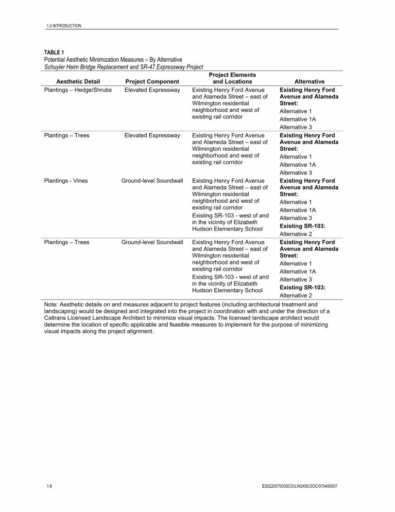
TABLE 1 Potential Aesthetic Minimization Measures – By Alternative Schuyler Heim Bridge Replacement and SR-47 Expressway Project
Aesthetic Detail Project Component Project Elements
and Locations Alternative Surface/Color Treatment Columns Schuyler Heim Bridge –
Dominguez Channel Crossing; Elevated Expressway – south and north of Schuyler Heim Bridge and north to Pacific Coast Highway; SR-103 Extension from near Hudson Elementary north to Alameda Street; Ocean Boulevard Flyover
Alternative 1 Alternative 1A Alternative 2 Alternative 3 Alternative 4 (no flyover under this alternative)
Surface/Color Treatment Roadway Barriers Schuyler Heim Bridge – Dominguez Channel Crossing; Elevated Expressway – south and north of Schuyler Heim Bridge and north to Pacific Coast Highway; SR-103 Extension from near Hudson Elementary north to Alameda Street; Ocean Boulevard Flyover
Alternative 1 Alternative 1A Alternative 2 Alternative 3 Alternative 4 (no flyover under this alternative)
Surface/Color Treatment Ground-level Soundwall Existing Henry Ford Avenue and Alameda Street – east of Wilmington residential neighborhood and west of existing rail corridor Existing SR-103 - west of and in the vicinity of Elizabeth Hudson Elementary School
Existing Henry Ford Avenue and Alameda Street: Alternative 1 Alternative 1A Alternative 3 Existing SR-103: Alternative 2

1.0 INTRODUCTION
ES022007003SCO/LW2459.DOC/070400007 1-7
TABLE 1 Potential Aesthetic Minimization Measures – By Alternative Schuyler Heim Bridge Replacement and SR-47 Expressway Project
Aesthetic Detail Project Component Project Elements
and Locations Alternative Surface/Color Treatment Elevated Soundwall Elevated Expressway over
Consolidated Slip – west of Leeward Bay Marina Elevated Expressway – over Henry Ford Avenue and Alameda Street – east of Wilmington residential neighborhood Elevated Expressway – SR-103 Extension - west of and in the vicinity of Elizabeth Hudson Elementary School
Elevated Expressway over Consolidated Slip: Alternative 1 Alternative 1A Alternative 3 Elevated Expressway over Consolidated Slip: Alternative 1 Alternative 1A Alternative 3 Elevated Expressway – SR-103 Extension: Alternative 2
Surface/Color Treatment Gore Points Northbound and southbound Schuyler Heim Approaches – at off-ramps/on-ramps Elevated Expressway – Eastbound Ocean Boulevard Flyover Elevated Expressway – SR-103 adjacent to Hudson Elementary School Elevated Expressway Return to Grade at Pacific Coast Highway Elevated Expressway – Return to grade south of I-405 on Alameda Street
Northbound and southbound Schuyler Heim Approaches: Alternative 1 Alternative 1A Alternative 2 Alternative 3 Alternative 4 Elevated Expressway – Eastbound Ocean Boulevard Flyover: Alternative 1 Alternative 1A Alternative 2 Alternative 3 Elevated Expressway – SR-103 adjacent to Hudson Elementary School: Alternative 2 Elevated Expressway Return to Grade at Pacific Coast Highway: Alternative 1 Alternative 1A Alternative 3 Elevated Expressway – Return to grade south of I-405 on Alameda Street: Alternative 2
1.0 INTRODUCTION
1-8 ES022007003SCO/LW2459.DOC/070400007
TABLE 1 Potential Aesthetic Minimization Measures – By Alternative Schuyler Heim Bridge Replacement and SR-47 Expressway Project
Aesthetic Detail Project Component Project Elements
and Locations Alternative Plantings – Hedge/Shrubs Elevated Expressway Existing Henry Ford Avenue
and Alameda Street – east of Wilmington residential neighborhood and west of existing rail corridor
Existing Henry Ford Avenue and Alameda Street: Alternative 1 Alternative 1A Alternative 3
Plantings – Trees Elevated Expressway Existing Henry Ford Avenue and Alameda Street – east of Wilmington residential neighborhood and west of existing rail corridor
Existing Henry Ford Avenue and Alameda Street: Alternative 1 Alternative 1A Alternative 3
Plantings - Vines Ground-level Soundwall Existing Henry Ford Avenue and Alameda Street – east of Wilmington residential neighborhood and west of existing rail corridor Existing SR-103 - west of and in the vicinity of Elizabeth Hudson Elementary School
Existing Henry Ford Avenue and Alameda Street: Alternative 1 Alternative 1A Alternative 3 Existing SR-103: Alternative 2
Plantings – Trees Ground-level Soundwall Existing Henry Ford Avenue and Alameda Street – east of Wilmington residential neighborhood and west of existing rail corridor Existing SR-103 - west of and in the vicinity of Elizabeth Hudson Elementary School
Existing Henry Ford Avenue and Alameda Street: Alternative 1 Alternative 1A Alternative 3 Existing SR-103: Alternative 2
Note: Aesthetic details on and measures adjacent to project features (including architectural treatment and landscaping) would be designed and integrated into the project in coordination with and under the direction of a Caltrans Licensed Landscape Architect to minimize visual impacts. The licensed landscape architect would determine the location of specific applicable and feasible measures to implement for the purpose of minimizing visual impacts along the project alignment.
ES022007003SCO/LW2459.DOC/070400007 2-1
2.0 Regulatory Setting
Federal, state, and regional and local requirements that pertain specifically to aesthetic resources and urban design in the proposed project area are summarized below.
2.1 Federal Requirements The National Environmental Policy Act of 1969 as amended (NEPA) establishes that the federal government use all practicable means to ensure all Americans safe, healthful, productive, and aesthetically and culturally pleasing surroundings (42 United States Code [U.S.C.] 4331[b][2]). To further emphasize this point, the Federal Highway Administration (FHWA) in its implementation of NEPA (23 U.S.C. 109[h]) directs that final decisions regarding projects are to be made in the best overall public interest taking into account adverse environmental impacts, including among others, the destruction or disruption of aesthetic values.
2.2 State Requirements The California Environmental Quality Act (CEQA) establishes that it is the policy of the state to take all action necessary to provide the people of the state “with…enjoyment of aesthetic, natural, scenic and historic environmental qualities.” (CA Public Resources Code Section 21001[b]).
2.3 Regional and Local Requirements The Port of Los Angeles Master Plan, City of Los Angeles General Plan, Wilmington-Harbor Community Plan, Port of Long Beach Master Plan, City of Long Beach Municipal Code, and City of Carson General Plan have general and specific goals and policies that pertain to transportation projects within their jurisdiction. A summary of those goals and policies related to visual resources is provided below.
2.3.1 Port of Los Angeles Master Plan The Port of Los Angeles Master Plan (1979, plus amendments) provides for the short- and long-term development, expansion, and alteration of the Port. The Port of Los Angeles Master Plan has been certified by the California Coastal Commission and is part of the Local Coastal Program (LCP) of the City of Los Angeles, and is consistent with the Port of Los Angeles Plan, an Element of the City’s General Plan. The Port of Los Angeles Master Plan does not contain any element specific to visual resources.
2.3.2 City of Los Angeles General Plan The City of Los Angeles General Plan is an advisory document comprising 11 Citywide Elements (Framework, Transportation, Infrastructure Systems, Housing, Noise, Air Quality, Conservation, Open Space, Historic Preservation and Cultural Resources, Safety, and

2.0 REGULATORY SETTING
2-2 ES022007003SCO/LW2459.DOC/070400007
Public Facilities and Services, and the Land Use Element. The Land Use Element, in turn, comprises 35 local area plans, known as Community Plans, as well as counterpart plans for the Port of Los Angeles and Los Angeles International Airport. The Port of Los Angeles Plan is intended to serve as the official 20-year guide to the continued development and operation of the Port, and is consistent with the Port Master Plan (City of Los Angeles, 1982).
The City of Los Angeles General Plan Land Use Map designates the John S. Gibson Boulevard, Pacific Avenue, Front Street, and Harbor Boulevard as Scenic Routes with specific acknowledgment of the views of harbor activities and the Vincent Thomas Bridge available to north- and southbound motorists (City of Los Angeles, 1999a). They are also designated as Super Truck Routes, a designation related to the volume of Port-related truck traffic accessing Port facilities along these roadways (City of Los Angeles, 1982). Front Street is additionally designated as a Scenic Route for its views westward of historic San Pedro. Harbor Boulevard, south of the Vincent Thomas Bridge, is similarly designated as a Scenic Route because of Port views (City of Los Angeles, 1999a). No other area roadways are designated scenic routes, and there are no officially designated scenic lookouts.
The City has not adopted formal guidelines governing the scenic corridors associated with designated scenic highways, but has established interim guidelines as part of the Transportation Element addressing roadway alignment, earthwork, signage, landscaping, and utilities (City of Los Angeles, 1999b).
The one objective of the City of Los Angeles General Plan that addresses aesthetic concerns is:
Objective 4: To assure priority for water and coastal-dependent development within the Port while maintaining and, where feasible, enhancing the coastal zone environment and public views of, and access to coastal resources.
2.3.3 Wilmington-Harbor City Community Plan The Wilmington-Harbor City Community Plan includes policies and standards for multiple residential, commercial, and industrial projects and for community design. These design policies and standards are to ensure that residential, commercial, and industrial projects and public spaces and rights-of-way incorporate specific elements of good design. The intent is to promote a stable and pleasant environment. In commercial corridors, the emphasis is on the provision and maintenance of the visual continuity of streetscapes and the creation of an environment that encourages pedestrian and economic activity. In industrial areas, the intent is to improve compatibility with the nonindustrial areas and encourage quality industrial development.
The community design and landscaping guidelines section establishes a set of guidelines to “improve the environment, both aesthetically and physically, as opportunities in the Wilmington-Harbor City Community Plan area occur which involve public improvements or other public and/or private projects that affect public spaces and rights-of way.”
The guidelines advocate that “public spaces and rights-of-way should capitalize on existing physical access to differentiate the community as a unique place in the City.” Additionally, the guidelines state “the presence or absence of street trees is an important ingredient in the aesthetic quality of an area. Consistent use of appropriate street trees provides shade during
2.0 REGULATORY SETTING
ES022007003SCO/LW2459.DOC/070400007 2-3
hot summer months, emphasizes sidewalk activity by separating vehicle and pedestrian traffic, and creates an area-wide identity which distinguishes neighborhoods within the Wilmington-Harbor City from each area.”
The following areas for improvements that address aesthetic concerns on major transportation corridors and are recommended within the guidelines include:
• Entryway Improvements • Streetscape • Street Trees • Street Lighting • Sidewalks/Paving • Signage
2.3.4 Port of Long Beach Master Plan The Port of Long Beach Master Plan includes a public access, visual quality, and recreational/tourist element (POLB, 1999). Visual quality is addressed in the following language from the Port of Long Beach Master Plan:
“The Port has several major responsibilities in the area of visual quality, particularly in regard to: (a) minimizing disruptive views, (b) landscaping or providing an attractive buffer between the recreational facilities and port industries, and (c) improving the appearance of Harbor lands at or along the major vehicular approaches. The Port has also made a commitment to providing enhanced comprehensive informational signage to provide better guidance to the public in reaching places of business and points of interest within the Harbor District.
The most sensitive views include:
• Predominant structures visible to the east from downtown Long Beach and along the ocean bluffs
• Ground-level views along the boundary of Queensway Bay
• Ground level views along Harbor Scenic Drive from southbound lanes south of Anaheim Street
Color, form, texture, and scale are the four criteria used during project review.”
2.3.5 City of Long Beach Municipal Code and General Plan The City of Long Beach Municipal Code (21.42.032) specifies “the landscape requirements for Port-related Industrial Zone (IP) zoned properties shall be those established in the Master Landscape Plan for the Port. The Port of Long Beach (POLB) Planning Bureau shall review and approve all landscape plans for projects located in the IP zone.” All properties located within the Long Beach portions of the proposed roadway corridor are zoned IP.
The City of Long Beach General Plan indicates that the responsibilities for planning within legal boundaries of the harbor lies with the Board of Harbor Commissioners.

2.0 REGULATORY SETTING
2-4 ES022007003SCO/LW2459.DOC/070400007
2.3.6 City of Carson General Plan The City of Carson General Plan Land Use Element and the Transportation and Infrastructure Element emphasize the general aesthetic environment of the City of Carson, and include provisions related to the specific aesthetic environment of the Alameda Corridor (City of Carson, 2004a; City of Carson, 2004b). The eastern side of Alameda Corridor between Dominguez Street and the southern boundary of the City is identified in the Land Use Element as a Special Study Area. Special study areas “offer special opportunities for development and redevelopment based on their size, location, access, or freeway visibility.” Goals, policies, and implementation measures included in the Land Use Element and Transportation and Infrastructure Element that address aesthetic concerns are presented below.
The City of Carson General Plan – Land Use Element guiding principle states that ”the City of Carson is committed to creating an attractive environment for its citizens by developing, implementing, and enforcing community design guidelines which will assure quality development and the maintenance and beautification of properties.”
The Land Use Element specifically states “property maintenance is important in Carson. In both residential neighborhoods and non-residential areas, focus should be placed on property maintenance and improvement.” The goal of the City is to “eliminate all evidence of property deterioration throughout Carson” and includes the following policy and implementation measure:
• Policy LU-9.3: Continue to promote and expand programs such as the Carson Beautification Program, which recognizes excellence in property upkeep in residential areas.
− Implementation LU-IM-9.7: Develop a design and improvement plan based on the City Capital Improvement Program including strengthened landscaping, identification graphics, and other physical improvements to enhance major public thoroughfares and activities areas.
The Land Use Element specifically lists the Alameda Corridor as an issue as follows: “While there are distinct advantages to the Alameda Corridor, there are also disadvantages. Traffic, noise, and economic impacts to businesses and residential neighborhoods immediately adjacent are among the primary issues.” The goal of the City is “development along the Alameda Corridor which is beneficial to residents, property owners, businesses, and the City.” The policy and implementation measure applicable to the project presented in the Land Use Element related to this goal include:
• Policy LU-10.2: Work with the existing applicable task forces and prepare a special study for those areas adversely impacted by the development of the Corridor.
− Implementation Measure LU-IM-10.1: Prepare a special study for those area(s) adversely impacted by the development of the Corridor, specifically that area east of the Alameda Corridor, between Dominguez Street and the southern boundary of the City. Provide appropriate mitigation for the impacts associated with the Corridor on the neighborhood.

2.0 REGULATORY SETTING
ES022007003SCO/LW2459.DOC/070400007 2-5
(Note: The special study for the Alameda Corridor has not yet been conducted [City of Carson, 2005a.)
The Land Use Element specifically identifies City Image as an issue as follows: “there are a number of unattractive and/or nonconforming land uses located along highly visible freeway corridors which impact the public’s perception of the community. Many of these properties are located in areas that can be considered ‘gateways’ into the City. Appropriate screening, landscaping, and buffering should be encouraged in order to improve the City’s image. In addition, entries into the City and key streets should be enhanced with landscaping and entry statements as appropriate.” The goal of the City is to “create a visually attractive appearance through Carson.” The policies and implementation measures applicable to the project presented in the Land Use Element related to this goal include:
• Policy LU-12.1: Develop and implement a Citywide Urban Design Plan.
− Implementation Measure LU-IM-12.1: Develop a Citywide Urban Design Plan.
(Note: The Urban Design Plan has not yet been developed [City of Carson, 2005b].)
• Policy LU-12.4: Amend the landscaping requirements in the Zoning Ordinance to enhance the appearance of the community and to provide for the use of trees to provide shade.
− Implementation Measure LU-IM-12.9: Enhance landscaping requirements and maintenance standards in the landscape section(s) of the City’s Ordinance.
− Implementation Measure LU-IM-12.10: Encourage drought-tolerant plant species, water conservation and related features in the landscape section(s) of the City’s Ordinance.
• Policy LU-12.5: Improve City appearance by requiring landscaping to screen, buffer, and unify new and existing development. Mandate continued upkeep of landscaped areas.
− Implementation Measure LU-IM-12.11: Require exposed structural sidewalls to be screened with landscaping.
− Implementation Measure LU-IM-12.12: Require landscaping to provide visual continuity along a street, even where the buildings are in different zones or land use districts.
− Implementation Measure LU-IM-12.13: When conflicting land uses adjoin, require a dense landscape screen to mitigate the friction between land uses.
Another goal provided under the City image issue is to “enhance freeway corridors and major arterials which act as gateways into the City of Carson.” The policies and implementation measures applicable to the project presented in the Land Use Element related to this goal include:
• Policy LU-14.1: Work with California Department of Transportation (Caltrans) to provide and maintain an attractive freeway environment in Carson, including access ramps.

2.0 REGULATORY SETTING
2-6 ES022007003SCO/LW2459.DOC/070400007
− Implementation Measure LU-IM-14.1: Provide and properly maintain appropriate freeway landscaping.
− Implementation Measure LU-IM-14.2: Enhance the landscaping near freeway on- and off-ramps to announce the driver’s entry into Carson.
− Implementation Measure LU-IM-14.3: Improve the surfaces of freeway structures visible to travelers with scoring, tile, landscaping, or other treatments to improve the raw, unfinished appearance of these structures.
• Policy LU-14.3: Provide entry markers with landscaping on the major arterials.
− Implementation Measure LU-IM-14.4: Design and fund attractive entry markers and areas for the major arterials.
The Transportation and Infrastructure Element specifically identifies improving the quality of transportation corridors as an issue as follows: “some of the City’s major transportation corridors are deficient in infrastructure maintenance and landscaping improvement.” The goal of the City is to “provide improved aesthetic enhancements to and maintenance of the City’s transportation corridors.” The policies and implementation measures applicable to the project presented in the Transportation and Infrastructure Element related to this goal include:
• Policy TI-7.1: Provide landscaped medians and greenbelts along major arterials, when economically feasible.
− Implementation Measure TI-IM-7.1: Through design standards and zoning requirements, require landscaped medians and parkways for all new development on major arterials.
• Policy TI-7.2: Encourage the aesthetic quality and maintenance of facilities within the City, under the jurisdiction of other agencies.
− Implementation Measure TI-IM-7.2: Pursue agreements within Caltrans to construct new soundwalls, as necessary, with landscaping, along all state freeways in the City.
• Policy TI-7.3: Target and prioritize street beautification programs along major transportation corridors.
− Implementation Measure TI-IM-7.4: Develop design plans for all major streets to provide walls, landscape features, and hardscape features, as appropriate, to protect and beautify neighborhoods to provide an aesthetic environment for the users of transportation corridors. First priority should be given to Avalon, south of Carson, and Wilmington, south of 213th Street.
− Implementation Measure TI-IM-7.5: Develop a land use and design plan for the Alameda Transportation Corridor to provide for appropriate uses, access, soundwalls, landscape features, and hardscape features, to protect and beautify the Dominguez area/neighborhoods as well as to limit access to Alameda and improve the flow of traffic.
(Note: The land use and design plan for the Alameda Transportation Corridor has not yet been developed [City of Carson, 2005a].)

ES022007003SCO/LW2459.DOC/070400007 3-1
3.0 Affected Environment
3.1 Study Methods and Procedures The process used in this visual impact study generally follows the guidelines outlined in the Federal Highway Administration’s Visual Impact Assessment for Highway Projects (FHWA, 1981).
Six principal steps required to assess visual impacts were carried out. They are as follows:
A. Define the project setting and viewshed B. Identify key views for visual assessment C. Analyze existing visual resources and viewer response D. Depict the visual appearance of project alternatives E. Assess the visual impacts of project alternatives F. Propose methods to mitigate adverse visual impacts
3.2 Existing Visual Environment A description of the visual environment is provided as a baseline for evaluating the significance of visual changes related to construction and operation of each of the alternatives. The setting provides a description of the existing visual setting, including any visually sensitive resources, views, and viewers in the study area, and is described in accordance with FHWA guidelines. The discussion focuses on issues and areas that have a bearing on potential impacts to visual resources.
This section describes the regional landscape, which establishes the general visual environment of the project area, and identifies the landscape units and project viewsheds identified for analysis in this report.
3.2.1 Regional Landscape The proposed project area (Figure 1) is located in southwestern Los Angeles County. The landscape in the project region is characterized by low-density urban development with scattered pockets of residential, commercial, industrial, public facilities, extraction, and open space land uses. The Ports of Los Angeles and Long Beach are located in the southern portion of the project region. The Schuyler Heim Bridge is generally located on the boundary between the two Ports. The majority of industrial uses in the project region are concentrated in the Ports and along and adjacent to Alameda Street, which extends north of the project area.
The project area is located on the southern portion of the Los Angeles Basin coastal plain and is characterized by relatively flat topography. The nearest naturally elevated features are the Palos Verdes hills, which are located approximately 4 miles to the west, and Signal Hill, which is located approximately 7 miles to the northeast.

3.0 AFFECTED ENVIRONMENT
3-2 ES022007003SCO/LW2459.DOC/070400007
The study area is bounded by the Ports of Los Angeles and Long Beach on the south, SR-91 (Artesia Freeway) on the north, I-110 (Harbor Freeway) on the west, I-710 (Long Beach Freeway) on the east.
3.2.2 Landscape Units To provide a clear description of the existing visual setting and to define anticipated impacts, the project area is divided into four landscape units. Landscape units are areas of distinct, but not necessarily homogenous, visual character that offer similar kinds of views toward the proposed project and/or within which there would likely be similar concerns about landscape issues. A landscape unit will often correspond to a place or district that is commonly known among local viewers. These landscape units provide the framework for analyzing the effects of the alternatives and developing appropriate impact mitigation measures.
The primary landscape units for the proposed project are shown in Figure 1 and include:
• Channel Landscape Unit • Wilmington Landscape Unit • Long Beach Landscape Unit • Carson Landscape Unit
A description of each of the landscape units is provided below. To support the descriptions, character photos are used in some cases to illustrate the existing visual conditions. In addition, within each landscape area, one or more simulation viewpoints were selected to capture views typical of those in the viewing area. Typical viewpoints are important because they provide a basis for evaluating the potential project visual effects of greatest concern. In selecting these viewpoints, the emphasis was placed on views from publicly accessible locations that have the potential to be seen by the largest numbers of sensitive viewers. The locations of the viewpoints used for the character photos and simulation views are indicated in Figure 1.
3.2.2.1 Channel Landscape Unit
The Channel Landscape Unit encompasses the area in the vicinity of the southernmost segment of the proposed project, which extends along Ocean Boulevard, from east of Navy Way, to the intersection with SR-47, and continues north along SR-47 to the intersection of Henry Ford Avenue and Anaheim Street. The landscape unit has been defined to extend eastward to the highpoint on the Gerald Desmond Bridge from which viewers are provided an expansive view of the southern portion of the project alignment, including the Schuyler Heim Bridge, and westward to Navy Way (Figures 2 through 8, Existing View).
This landscape unit includes portions of Terminal Island, including a segment of Ocean Boulevard, and the Cerritos Channel, the marinas and Port lands on the north side of the Cerritos Channel, and the Consolidated Slip and Dominguez Channel. The terrain in this landscape area is essentially flat; but elevated views are available to travelers on the Gerald Desmond Bridge and Schuyler Heim Bridge, the elevated sections of the roadway south and north of the Schuyler Heim Bridge, and sections of Ocean Boulevard, east of Navy Way.
3.0 AFFECTED ENVIRONMENT
ES022007003SCO/LW2459.DOC/070400007 3-3
Most of the land in this landscape unit is a part of either the Port of Los Angeles or Port of Long Beach, and the north/south SR-47 alignment in this area lies along the approximate boundary between the two Ports. Land use in this area reflects its role as part of the Port complex. Two large shipping terminals line the banks of the Cerritos Channel. A large area on the south side of the channel to east side of the Schuyler Heim Bridge has been cleared by the Port of Long Beach to accommodate additional terminal development. A new above-grade Ocean Boulevard alignment is under construction, on a separate Port of Long Beach project, south of the existing Ocean Boulevard (Figure 5, Existing View). Other uses in the area include large paved areas used for backland storage, a power plant, and tank storage facilities. The Union Pacific Railroad is located west of SR-47, south of the Terminal Island Freeway (SR-103), and crosses the Cerritos Channel via Badger Bridge, a lift bridge located directly west of Schuyler Heim Bridge. Marinas located in both the Cerritos Channel and Dominguez Channel contain vessels with live-aboard residents, and these marinas are where stationary, sensitive viewers are located within this landscape unit (Figures 6, 7, and 8, Existing View). No other residences are located within the Channel Landscape Unit.
3.2.2.2 Wilmington Landscape Unit
The Wilmington Landscape Unit encompasses the portion of the proposed project north of the Channel Landscape Unit that includes Henry Ford Avenue from the intersection with Anaheim Street, north to the intersection with Alameda Street, and the Alameda Street corridor to just north of Pacific Coast Highway. This landscape unit has been defined to include the heavy industrial, light industrial, and commercial properties that provide Port-related support and the view seen by potentially sensitive viewers located in the residential area west of the proposed project alignment (Figure 9, Existing View).
This landscape unit is dominated by Port-related and heavy industrial, light industrial, and commercial properties, including oil refineries, container storage, recycling facilities, and the adjacent utility and rail corridors. A social club, the Union Mutualista de San Jose, is located on the west side of Henry Ford Avenue between East Opp Street and East Grant Street. The Alameda Corridor, an above-grade rail line, runs parallel to and is located immediately adjacent to the west side of Alameda Street in this section of the project alignment. The terrain in this landscape unit is generally flat with no elevated views available to travelers. Land use in this area reflects its supporting role to Port-related activities. No residences are located on Henry Ford Avenue or Alameda Street. A pocket of residential properties and an elementary school, however, are located immediately west of the intersection of Henry Ford Avenue and Alameda Street, west of an existing rail line, between approximately Grant Street to the south and Robidoux Street to the north.
3.2.2.3 Long Beach Landscape Unit
The Long Beach Landscape Unit encompasses the southern portion of the proposed project alignment along SR-103 from the area south of Hudson Park, north to the intersection at Willow Street/Sepulveda Boulevard. This landscape unit was defined to include the residences in Long Beach east of Elizabeth Hudson Elementary School. The view from Elizabeth Hudson Elementary School looking northwest toward the existing SR-103 alignment and the rail line and electric transmission corridor west of SR-103 is shown in Figure 10, Existing View. The students and teachers of Elizabeth Hudson Elementary and

3.0 AFFECTED ENVIRONMENT
3-4 ES022007003SCO/LW2459.DOC/070400007
users of the associated public land are considered stationary, sensitive viewers within this landscape.
This landscape unit is divided approximately east/west by the existing SR-103 alignment. The area west of SR-103 in this section of the alignment is dominated by the ICTF. Additionally, the Union Pacific Railroad line (property owned by the Ports of Los Angeles and Long Beach), an above-grade rail line, runs approximately parallel to, and west of, SR-103. An SCE high transmission corridor is also located west of SR-103. The terrain is generally flat, and no residences are located west of SR-103. The area east of the existing SR-103 alignment in this section of the proposed project includes a single-family residential area located to the east of Hudson Park, Elizabeth Hudson Elementary School (440 Webster Street), and Cambodian Buddhist Temple (2100 West Willow Street).
3.2.2.4 Carson Landscape Unit
The Carson Landscape Unit encompasses the northern portion of the proposed project alignment along SR-103 from Sepulveda Boulevard, north-northwest to east of the Dominguez Channel, then north to Alameda Street to just south of the 223rd Street on- /off-ramp. This landscape unit was defined to include the entry route into Carson south along Alameda Street, south of I-405 (Figure 11, Existing View). Policies of the City of Carson are generally concerned about the gateways to this city. The views of travelers heading south on Alameda Street from the 223rd Street on- /off-ramp, therefore, are considered in this analysis.
This landscape unit primarily encompasses the ICTF north of Sepulveda Boulevard within unincorporated Los Angeles County. From Sepulveda Boulevard, the project alignment heads north-northwest across the ICTF to east of the Dominguez Channel, then heads north to Alameda Street, just south of the 223rd Street on-/off-ramp. Properties along the alignment include the ICTF and other heavy industrial and light industrial properties. Properties along Alameda Street also include heavy industrial, light industrial, and commercial facilities. The Alameda Corridor (an above-grade rail line) is located directly west of Alameda Street within this landscape unit. The terrain is generally flat, and no residences are located on this alignment. Vegetation is limited to landscaping located in some areas along the road corridor.
3.2.3 Project Viewshed A viewshed is a subset of a landscape unit and is comprised of all the surface areas visible from an observer’s viewpoint. The limits of a viewshed are defined as the visual limits of the views toward the proposed project. The viewshed also includes the locations of viewers likely to be affected by visual changes brought about by project features. Potential viewsheds extend out into the surrounding area. But, from many areas in the flat urban landscape, views toward the proposed alignments and structures are substantially screened by intervening structures and, in some cases, vegetation. The viewsheds for this project include locations within the four landscape units where viewers are likely to be affected by visual changes brought about by the project features. For the purposes of this analysis, viewsheds are the areas defined by the boundaries of the landscape units.

3.0 AFFECTED ENVIRONMENT
ES022007003SCO/LW2459.DOC/070400007 3-5
3.3 Existing Visual Resources and Viewer Response
3.3.1 FHWA Method of Visual Resource Analysis Identify Visual Character – Visual character is descriptive and nonevaluative, which means it is based on defined attributes that are neither good nor bad in themselves. A change in visual character cannot be described as having good or bad attributes until it is compared with the viewer response to that change. If there is public preference for the established visual character of a regional landscape and resistance to a project that would contrast with that character, then changes in the visual character can be evaluated.
Assess Visual Quality – Visual quality is evaluated by identifying the vividness, intactness, and unity present in the viewshed. The FHWA states that this method should correlate with public judgments of visual quality well enough to predict those judgments. This approach is particularly useful in highway planning because it does not presume that a highway project is necessarily an eyesore. This approach to evaluating visual quality can also help identify specific methods for mitigating each adverse impact that may occur as a result of a project. The three criteria for evaluating visual quality can be defined as follows:
Vividness is the visual power or memorability of landscape components as they combine in distinctive visual patterns.
Intactness is the visual integrity of the natural and man-built landscape and its freedom from encroaching elements. It can be present in well-kept urban and rural landscapes, as well as in natural settings.
Unity is the visual coherence and compositional harmony of the landscape considered as a whole. It frequently attests to the careful design of individual manmade components in the landscape.
Visual quality evaluation forms of existing conditions of selected key viewpoints in each landscape unit are included in Appendix B.
3.3.2 Existing Visual Resources The existing visual character and visual quality of each of the landscape units are discussed below.
3.3.2.1 Existing Visual Character
3.3.2.1.1 Channel Landscape Unit The primary view from the west side of the Gerald Desmond Bridge to the northwest includes the Schuyler Heim Bridge, Badger Avenue Bridge, and the elevated portions of SR-47 located north and south of the Schuyler Heim Bridge; towards the north the view includes the heavy port uses north and south of Ocean Boulevard. The heavy industrial land uses associated with Port activities, including the open-water shipping channel, container ships, and container facilities, and associated structures (marine terminals, container handling facilities, bulk material handling facilities, and large overhead cranes) are part of the expansive view. High-voltage transmission towers and aboveground utilities, a power substation, and open land slated for future Port development are included in the heavily industrial view (Figures 2 through 4, Existing View).

3.0 AFFECTED ENVIRONMENT
3-6 ES022007003SCO/LW2459.DOC/070400007
The primary views from Ocean Boulevard, from the east side of Navy Way towards the northeast, is the existing at-grade Ocean Boulevard and the new alignment of the above-grade Ocean Boulevard under construction just south of the existing road (a separate Port of Long Beach project). Additionally, heavily developed port-related facilities and structures are located within the view (roadside fencing, office building, container terminals, aboveground utilities, and storage facilities). The apex of the Gerald Desmond Bridge is visible above the new alignment of the above-grade Ocean Boulevard under construction; however, the distinctive Long Beach city skyline is partially blocked by the security fencing between Ocean Boulevard and Pier T to the south (Figure 5, Existing View).
The primary views from the Cerritos Channel Anchorage Way Marinas are of the Schuyler Heim Bridge and Badger Avenue Bridge, and other heavy industrial land uses associated with Port activities, including marine terminals, container-handling facilities, bulk material handling facilities, large overhead cranes, and storage facilities. The open water of the Cerritos Channel and associated marine vessels at the Anchorage Way Marinas are part of the near view (Figure 6 and 7, Existing View).
The primary views from the Consolidated Slip Marina (Leeward Bay Marina) are of the two elevated rail truss bridges and Henry Ford Avenue north of the SR-47, with the Port activities, including large overhead cranes, on the horizon to the southeast. Additionally, an oil refinery, aboveground utilities, and heavy industrial land uses associated with Port activities are part of the expansive view. The open water of the Consolidated Slip and associated marine vessels, marina office, and restaurant at Leeward Bay Marina are part of the near view (Figure 8, Existing View).
3.3.2.1.2 Wilmington Landscape Unit The view from the residential neighborhood west of Alameda Street toward the proposed project alignment is across the existing rail corridor ROW to the heavy industrial uses along Henry Ford Avenue, including traffic on Henry Ford Avenue, recycling facilities, oil refinery facilities, and aboveground utilities in the area (Figure 9, Existing View).
3.3.2.1.3 Long Beach Landscape Unit The view from the Hudson Elementary School sports field includes heavy traffic on SR-103 and the existing rail line west of SR-103. Additionally, the ICTF structures, container storage facilities, and the SCE high-voltage transmission corridor are part of the view. Beyond the ICTF, heavy industrial facilities are visible from Hudson School (Figure 10, Existing View).
3.3.2.1.4 Carson Landscape Unit The primary view of the proposed alignment from the intersection of the I-405/223rd Street off-ramps south along Alameda Street includes a mix of light industrial and commercial properties, vacant lots, and utility and rail ROWs (Figure 11, Existing View).
3.3.2.2 Existing Visual Quality
The existing visual quality of the four landscape units is described below.
3.3.2.2.1 Channel Landscape Unit The general visual character of the Channel Landscape Unit is characterized as “low” because of the adjacent Port-related activities, many of which have a heavy industrial character. The industrial uses are similar in character within this landscape unit; but they

3.0 AFFECTED ENVIRONMENT
ES022007003SCO/LW2459.DOC/070400007 3-7
lack visual vividness, intactness, or unity. There is very little vegetation, except for landscaping associated with commercial properties and along a few transportation corridors. The Dominguez Channel is bordered by a concrete levy on either side; the Cerritos Channel is bordered by concrete levies and manufactured pilings.
The majority of public views within the Channel Landscape Unit encompass transportation corridors, including local streets; rail and utility corridors; and heavy industrial, light industrial, and commercial uses (Figures 2 through 5, Existing View). Publicly available views of the marine channel are generally limited to the views seen from the marinas in the Cerritos Channel and Consolidated Slip and these views are dominated by Port and infrastructure facilities (Figures 6 through 8, Existing View). The Channel Landscape Unit contains no unique visual resources. Local city and community plans do not designate any roads within or near the landscape unit as scenic or of special importance.
3.3.2.2.2 Wilmington Landscape Unit The general visual character of the Wilmington Landscape Unit is characterized as “low” because of the presence of heavy industrial and light industrial uses intermixed with commercial and residential uses. The industrial and commercial uses are similar in character within this landscape unit; but they lack visual vividness, intactness, or unity. There is very little vegetation, except for landscaping associated with commercial and residential properties and along a few roadways.
The public views along and east of Henry Ford Avenue and Alameda Street are dominated by local streets; rail and utility corridors; and heavy industrial, light industrial, and commercial uses. The public views west of Henry Ford Avenue and Alameda Street include foreground views of residential areas with a moderate level of visual quality (Figure 9, Existing View). Large-scale industrial and infrastructure facilities are sometimes visible in the middleground or background of this view. The Wilmington Landscape Unit contains no unique visual resources. Local city and community plans do not designate any roads within or near the landscape unit as scenic or of special visual importance.
3.3.2.2.3 Long Beach Landscape Unit The general visual character of the Long Beach Landscape Unit is characterized as “low” to “moderately low” because of the presence of heavy industrial and transportation uses and facilities intermixed with commercial and residential uses. The industrial uses west of SR-103 are similar in character within this landscape unit; but they lack visual vividness, intactness, or unity. The park and institutional facilities and the residential neighborhood east of SR-103 have a low degree of vividness and a moderately low level of intactness and unity.
The public views along and west of SR-103 are dominated by local streets, rail and utility corridors, and heavy industrial and light industrial uses (Figure 10, Existing View). The public views east of SR-103 include foreground views of residential and park areas with a moderately low level of visual quality Large-scale industrial and infrastructure facilities are sometimes visible in the middleground or background of this view. The Long Beach Landscape Unit contains no unique visual resources. Local city and community plans do not designate any roads within or near the landscape unit as scenic or of special visual importance.

3.0 AFFECTED ENVIRONMENT
3-8 ES022007003SCO/LW2459.DOC/070400007
3.3.2.2.4 Carson Landscape Unit The general visual character of the Carson Landscape Unit is characterized as “low” because of the concentration of heavy industrial and light industrial uses intermixed with commercial uses. The industrial and commercial uses are similar in character within this landscape unit; but they lack visual vividness, intactness, or unity. There is very little vegetation, except for landscaping associated with commercial properties and along Alameda Street.
The majority of public views within the Carson Landscape Unit are dominated by transportation corridors, including local streets; rail and utility corridors; and heavy industrial, light industrial, and commercial uses (Figure 11, Existing View). The Carson Landscape Unit contains no unique visual resources. Local city and community plans do not designate any roads within or near the landscape unit as scenic. Goals of the City of Carson General Plan - Land Use Element address the Alameda Street/I-405 corridor and include “development along the Alameda Corridor which is beneficial to residents, property owners, businesses, and the City,” “create a visually attractive appearance through Carson,” “enhance freeway corridors and major arterials which act as gateways into the City of Carson,” and “provide improved aesthetic enhancements to and maintenance of the City’s transportation corridors” (Section 2.3, Regional and Local Requirements, City of Carson General Plan).
3.3.3 Methods of Predicting Viewer Response Viewer response is composed of two elements: viewer sensitivity and viewer exposure. These elements combine to form a method of predicting how the public might react to visual changes brought about by a highway project.
Viewer sensitivity is defined both as the viewers’ concern for scenic quality and the viewers’ response to change in the visual resources that make up the view. Local values and goals may confer visual significance on landscape components and areas that would otherwise appear unexceptional in a visual resource analysis. Even when the existing appearance of a project site is uninspiring, a community may still object to projects that fall short of its visual goals. Analysts can learn about these special resources and community aspirations for visual quality through citizen participation procedures, as well as from local publications and planning documents.
Viewer exposure is typically assessed by measuring the number of viewers exposed to the resource change, type of viewer activity, duration of the view, speed at which the viewer moves, and position of the viewer. High viewer exposure heightens the importance of early consideration of design, art, and architecture and their roles in managing the visual resource effects of a project.
3.3.4 Existing Viewer Sensitivity The communities located along the project alignment have developed general, community, and master plans that contain goals, policies, and implementation measures that indicated the residents’ values and expectations for their visual environment. The specific details of each of the general, community, and master plans are provided in Section 2.3, Regional and

3.0 AFFECTED ENVIRONMENT
ES022007003SCO/LW2459.DOC/070400007 3-9
Local Requirements. The following are some guidelines that illustrate which visual features are important to local communities and viewers:
Maintain and, where feasible, enhance the coastal zone environment and public views of, and access to coastal resources (City of Los Angeles, 1982).
Differentiate the community as unique in the City (City of Los Angeles, 1999).
Consistent use of appropriate street trees provides shade during hot summer months, emphasizes sidewalk activity by separating vehicle and pedestrian traffic, and creates an area-wide identity which distinguishes neighborhoods (City of Los Angeles, 1999).
Minimize disruptive views, landscape or provide an attractive buffer between the recreational facilities and port industries, and Improve the appearance of Harbor lands at or along the major vehicular approaches (Long Beach Harbor Department, 1999).
Provide enhanced comprehensive informational signage to provide better guidance to the public in reaching places of business and points of interest (Long Beach Harbor Department, 1999).
Focus should be placed on property maintenance and improvement in both residential neighborhoods and non-residential areas (City of Carson, 2004a).
Develop a design and improvement plan based on the City Capital Improvement Program including strengthened landscaping, identification graphics, and other physical improvements to enhance major public thoroughfares and activities areas (City of Carson, 2004a).
Appropriate screening, landscaping, and buffering should be encouraged in order to improve the City’s image. In addition, entries into the City and key streets should be enhanced with landscaping and entry statements as appropriate (City of Carson, 2004a).
Amend the landscaping requirements in the Zoning Ordinance to enhance the appearance of the community and to provide for the use of trees to provide shade (City of Carson, 2004a).
Provide and properly maintain appropriate freeway landscaping (City of Carson, 2004a).
Enhance the landscaping near freeway on- and off-ramps to announce the driver’s entry into Carson (City of Carson, 2004a).
Improve the surfaces of freeway structures visible to travelers with scoring, tile, landscaping, or other treatments to improve the raw, unfinished appearance of these structures (City of Carson, 2004a).
The general, community, and master plans emphasize, as a common theme, the importance of landscaping as a dominant visual element. Design themes are expressed primarily through plant material (e.g., street trees). Streetscaping, including signage, furniture, lighting, walls and fencing, monumentation, and architectural treatment and graphics, also play an important role in the plans. The communities recognize the perception of each community is formed, to a large degree, by what people observe through their windshields.

3.0 AFFECTED ENVIRONMENT
3-10 ES022007003SCO/LW2459.DOC/070400007
3.3.5 Existing Viewer Groups, Viewer Exposure, and Viewer Awareness
3.3.5.1 Roadway Users
3.3.5.1.1 SR-47, Henry Ford Avenue, Alameda Street The project would be located along portions of SR-47, Henry Ford Avenue, and Alameda Street. Commercial and passenger vehicle drivers and passengers would have foreground views of the project for the duration of their travel on the roadway segments. Drivers and passengers will likely have a moderate to high awareness of the project and moderate concern about the effects of the project on their view.
3.3.5.1.2 SR-103 The project would be located along the existing northern segment of SR-103 and extend north from Sepulveda/Willow Street to Alameda Street. Commercial and passenger vehicle drivers and passengers would have foreground views of the project. Drivers and passengers will likely have a moderate to high awareness of the project and moderate concern about the effects of the project on their view.
3.3.5.1.3 I-405 The northern terminus of the SR-103 Extension would be located just south of the I-405/ 223rd Street on- /off-ramp at Alameda Street. The view from the southbound lanes of I-405 of Alameda Street to the south is very limited due to the presence of the 223rd Street overpass. The 223rd Street overpass is located between the I-405 overpass over Alameda Street and the proposed project. Drivers traveling at normal freeway speeds usually focus attention on long-range, nonperipheral views. Passengers may have a heightened awareness of wide-range views. Travelers experiencing congested traffic conditions will tend to focus on views from the freeway. Daily commuters (Los Angeles to Orange County) may have an increased awareness of views from the freeway due to the amount of time spent on the facility every day. Driver and passengers on I-405 may have low awareness of the features of the alternatives and have a low concern about the effects of the project on their obstructed view.
3.3.5.1.4 Ocean Boulevard The project extends along Ocean Boulevard, east of Navy Way, to the intersection with SR-47, then the project continues north on SR-47 from Ocean Boulevard across the Schuyler Heim Bridge. Commercial and passenger vehicle drivers and passengers crossing west on the Gerald Desmond Bridge would have middleground to background views of the project for a short duration from the elevated portion of the bridge. Drivers and passengers on the bridge will likely have a low to moderate awareness of the southern terminus of the project and low to moderate concern about the effects of the project on their view. Additionally, drivers and passengers on Ocean Boulevard at the western terminus of the project would have foreground views of the flyover component of the project for a short duration. Drivers and passengers will likely have a high awareness of the western terminus of the project and low concern about the effects of the project on their view.
3.3.5.2 Residents of Nearby Communities
3.3.5.2.1 Channel Landscape Unit Residents Anchorage Way Marinas residents would have middleground views of the Schuyler Heim Bridge and SR-47 viaduct north and south of the Schuyler Heim Bridge portions of the

3.0 AFFECTED ENVIRONMENT
ES022007003SCO/LW2459.DOC/070400007 3-11
project, and a few would have middleground views of the location at which the flyover from eastbound Ocean Boulevard ties into the southern approach to the bridge, for long periods of time. Leeward Bay Marina residents would have foreground to middleground views of the elevated viaduct over the Dominguez Channel for long periods of time. Live-aboard residents, particularly those in the Leeward Bay Marina, may have an acute awareness of the features of the alternatives and have a high concern about the effects of the project on the views from their vessels and marinas.
3.3.5.2.2 Wilmington Landscape Unit Residents Residents of the Wilmington neighborhood, located immediately west of the intersection of Henry Ford Avenue and Alameda Street, west of an existing rail line, between approximately Grant Street and Robidoux Street, would have middleground views of the elevated viaduct of long duration. These residents are likely to have a high concern about the project and its effect on views from their homes and neighborhood.
3.3.5.2.3 Long Beach Landscape Unit Residents Residents of the Long Beach neighborhood located east of Elizabeth Hudson Elementary School would have a background view of long duration of the transmission lines west of SR-103 that would be raised to accommodate the elevated section of SR-103 west of the school. Most of the residents would have no view of the viaduct west of the school; a few residences immediately east of Hudson School may have middleground views of long duration across the school playground and Hudson Park of the viaduct and elevated transmission lines. The residents with a middleground view are likely to have a high concern about the project and its effect on views from their homes and neighborhood. The residents with a background view of the transmission lines are likely to have moderate concern about the project and its effect on views from their homes and neighborhood.
3.3.5.2.4 Carson Landscape Unit Residents No residents of Carson live adjacent to the proposed project. Based on the general, master, and community plans summarized above, however, community residents are concerned with the quality of views from the I-405 into their community, particularly at gateways into their community.
Residents of Long Beach within the Carson Landscape Unit, located east of the ICTF, do not have views of the proposed SR-103 Extension. The SR-103 Extension would not be visible from residences located east of the railroad corridor because the view is blocked by the soundwalls located adjacent to the railroad corridor. Due to the flat topography of the area, the SR-103 Extension would not be visible from residences located west of the railroad corridor.
3.3.5.3 Recreational Facility and Marina Users The project is located adjacent to the Port of Long Beach and Port of Los Angeles. Recreational users of the open-water marine channels within the Ports would have foreground, middleground, and background views of the project as they traverse the open water for short to long periods of time. The recreational users of the open-water marine channels may have an acute awareness of the features of the alternatives and have a high concern about the effects of the project on their view.

3.0 AFFECTED ENVIRONMENT
3-12 ES022007003SCO/LW2459.DOC/070400007
A number of commercial facilities (e.g., restaurants and boat repair) are located adjacent to the marinas in both the Cerritos Channel and Dominguez Channel. Marina users would have middleground to background views of the project for short periods of time. Marina patrons will likely have a low to moderate awareness of the project and moderate concern about the effects of the project on their view.
The SR-103 project alignment is located adjacent to Hudson Elementary School and Hudson Park. Users of Hudson Park and Hudson Elementary School playground would have middleground views of the SR-103 Extension for long periods of time. The recreational users of Hudson Park and Hudson Elementary School playground may have an acute awareness of the features of the alternatives and have a high concern about the effects of the project on their view.
3.3.5.3.1 Port, Marina, Industrial, and Commercial Facilities Employees Employees would have foreground, middleground, and background views of the project for short to long time periods depending on the location and type of their employment. Employees in the Channel Landscape Unit working outside adjacent to the open-water channels (e.g., boat repair) will likely have a moderate to high awareness of the project and moderate to high concern about the effects of the project on their view. Employees in the Wilmington Landscape Unit, Long Beach Landscape Unit, and Carson Landscape Unit would have foreground views of the project for short duration if work is conducted indoors, and long duration if work is conducted outdoors. Employees working outdoors would have moderate to high awareness of the project and moderate to high concern about the effects of the project on their view if located next to project alignment. They would have moderate awareness of the project and moderate concern about the effects of the project on their view if not located immediately adjacent to the project alignment. Employees working indoors in all four landscape units would have low to moderate awareness of the project and low to moderate concern about the effects of the project on their view.
ES022007003SCO/LW2459.DOC/070400007 4-1
4.0 Environmental Consequences
4.1 Permanent Impacts
4.1.1 Method of Assessing Project Impacts NEPA requires consideration of visual resource impacts of projects in preparation of environmental documents. In the FHWA visual analysis system, a project alternative could have a significant visual impact if it results in a substantial change in the overall visual character or quality that has an adverse effect on viewer response.
Visual resource change is the sum of the change in visual character and change in visual quality. The first step in determining visual resource change is to assess the compatibility of the alternative with the visual character of the existing landscape. The second step is to compare the visual quality of the existing resources with projected visual quality after the project alternative is constructed.
The viewer response to project changes is the sum of viewer exposure and viewer sensitivity to the project as determined in the preceding section.
The resulting visual impact level is determined by combining the severity of resource change with the degree to which people are likely to oppose the change. Definitions of visual impact level and whether mitigation is required are provided below.
4.1.2 Definition of Visual Impact Levels Low - Minor adverse change to the existing visual resource, with low viewer response to change in the visual environment. May or may not require mitigation.
Moderate - Moderate adverse change to the visual resource with moderate viewer response. Impact can be mitigated within 5 years using conventional practices.
Moderately High - Moderate adverse visual resource change with high viewer response or high adverse visual resource change with moderate viewer response. Extraordinary mitigation practices may be required. Landscape treatment required will generally take longer than 5 years to mitigate.
High - A high level of adverse change to the resource or a high level of viewer response to visual change such that architectural design and landscape treatment cannot mitigate the impacts. Viewer response level is high. An alternative project design may be required to avoid highly adverse impacts.
4.1.3 Analysis of Key Views Because it is not feasible to analyze all the views in which the alternative would be seen, it is necessary to select a number of key viewpoints that would most clearly display the visual effects of the project. Key views also represent the primary viewer groups that would

4.0 ENVIRONMENTAL CONSEQUENCES
4-2 ES022007003SCO/LW2459.DOC/070400007
potentially be affected by the proposed project. Key view locations are shown in Figure 1. Copies of visual quality evaluation forms (existing conditions and with the project) of selected key views within each landscape unit are included in Appendix B. Additionally, changes in visual quality evaluations, by key view and alternative, are presented in two tables included in Appendix B.
The potential permanent primary and secondary visual impacts are described in detail below. For each key view analyzed, only the project elements potentially visible from the key view are described and evaluated.
Aesthetic details on and measures adjacent to project features (including architectural treatment and landscaping) would be designed and integrated into the project in coordination with and under the direction of a Caltrans Licensed Landscape Architect to minimize visual impacts. Examples of minimization features that could be incorporated into the project are provided in Table 1, Section 1.3, and are depicted in the photo simulations at key views (Figures 2 through 11). The licensed landscape architect would determine the location of specific applicable and feasible measures to implement in order to minimize visual impacts along the project alignment.
4.1.3.1 Key View 1 – Channel Landscape Unit (Gerald Desmond Bridge)
• Looking approximately west and southwest from westbound Ocean Boulevard on the Gerald Desmond Bridge: (a) is looking approximately to the west and (b) is looking approximately southwest
Orientation This key view simulation depicts the changes in the visual environment due to replacement of the Schuyler Heim Bridge as observed by westbound Ocean Boulevard/Gerald Desmond Bridge travelers (Figures 2, 3, and 4). This key view also depicts the visual effects of changes to the SR-47 northbound and southbound approaches to the Schuyler Heim, and construction of the flyover, on westbound Gerald Desmond Bridge travelers.
Existing Visual Character/Quality The existing visual character of the view from the Gerald Desmond Bridge is generally highly industrialized, Port-dominated landscape with “low” visual quality. The existing visual character and visual quality are described in detail in Section 3.3.2.1 and Section 3.3.2.2, respectively.
4.1.3.1.1 Alternative 1 – Bridge Replacement and Expressway Proposed Project Features Alternative 1 would replace the existing Schuyler Heim Bridge (currently a lift bridge) with a new fixed-span bridge primarily within the existing bridge ROW (Figure 2, Simulation View). The existing Schuyler Heim Bridge would be demolished under this alternative. The proposed bridge would be approximately 13 m (43 ft) wider than the existing bridge and include four northbound lanes, three southbound lanes, and standard shoulders. The new bridge would be supported by four piers in the channel, with a minimum clearance of 14.3 m (47 ft) over the MHWL, which would be maintained for the width of the 102 m (335 ft) navigable channel.

4.0 ENVIRONMENTAL CONSEQUENCES
ES022007003SCO/LW2459.DOC/070400007 4-3
Under Alternative 1, the new SR-47 Expressway would begin at the intersection of SR-47 and Ocean Boulevard and over New Dock Street and continue onto the Schuyler Heim Bridge replacement (described above). The flyover from eastbound Ocean Boulevard to northbound SR-47 would connect to the southern approach to the Schuyler Heim Bridge north of Ocean Boulevard under Alternative 1 (Figure 4, Simulation View). A new northbound on-ramp would be constructed from New Dock Street to SR-47, and a new southbound off-ramp would be constructed from SR-47 to New Dock Street on Terminal Island. The expressway would extend northward from the new Schuyler Heim Bridge as an elevated viaduct to Alameda Street. A northbound off-ramp and southbound on-ramp would be constructed from Henry Ford Avenue to the elevated SR-47 on the mainland. The viaduct would return to grade just south of Pacific Coast Highway and continue at grade to just north of Pacific Coast Highway. This alternative includes improvements to the Alameda Street/Wardlow Road connector and to Alameda Street north and south of the connector at the northern terminus of the project (Figure 1).The expressway would be a four-lane, limited access roadway.
Aesthetic details on and adjacent to project features would be designed in coordination with and under the direction of a Caltrans Landscape Architect as described in Section 1.3, Project and Alternatives.
Alternative 1 would maintain connectivity with SR-103 through ramp modifications within the Channel Landscape Unit (Figure 1).
Soundwalls would be installed on the west side of the elevated expressway over the Consolidated Slip, on the west side of the elevated expressway east of the Wilmington neighborhood, and at grade west of the Henry Ford Avenue/Alameda Street and the railroad tracks east of the Wilmington neighborhood (see the Schuyler Heim Bridge Replacement and SR-47 Project, Noise Technical Report [CH2M HILL, 2005]).
Change to Visual Character/Quality The proposed demolition of the existing lift bridge structure and reconstruction of the Schuyler Heim Bridge as a fixed-span bridge would be a change in the visual environment. The new bridge would not include the towers associated with the existing lift structure. The change would not affect the character of the view, which would remain a view of a highly industrialized, Port-dominated landscape that would continue to include a bridge spanning the Cerritos Channel. The proposed bridge design would slightly reduce the visual clutter of the view over the Cerritos Channel and eliminate the Schuyler Heim Bridge towers that currently create a slight blockage of the view from the west toward the Badger Bridge lift structure towers (Figure 3, Simulation View).
The proposed reconstruction of SR-47 and northbound on-/off-ramps and southbound on-/off-ramps at New Dock Street and Henry Ford Avenue would be a change in the visual environment. The modification of SR-47, however, would not affect the unity, intactness, or texture of the visual quality of the key view. The view would continue to include a modified SR-47, a truck-dominated transportation corridor, at approximately the same location.
Modifications to the SR-103 transition ramps and the SR-47 elevated expressway north of the Schuyler Heim Bridge are not visible from Key View 1. Therefore, no further discussion

4.0 ENVIRONMENTAL CONSEQUENCES
4-4 ES022007003SCO/LW2459.DOC/070400007
regarding the SR-103 transition ramps and SR-47 elevated expressway north of the Schuyler Heim Bridge are included in the analysis of this key view.
Viewer Response The travelers using Ocean Boulevard, westbound over the Gerald Desmond Bridge, have middleground views of the Schuyler Heim Bridge and SR-47 northbound and southbound approaches of the bridge. The view from the Gerald Desmond Bridge is of a complex landscape due to the heavily industrialized nature of Port-related activities. Viewer awareness of the changes is likely to be low because duration of the view is short and the features proposed for change and modifications do not stand out in the complex landscape. The level of viewer response to the proposed demolition of the existing Schuyler Heim Bridge lift bridge and replacement with a fixed-span bridge and modification of SR-47 northbound and southbound approaches is anticipated to be low because there is no overall change in the visual character or visual quality of the view.
Resulting Visual Impact No substantial change to the visual character and visual quality of Key View 1 would occur with implementation of Alternative 1. Viewer awareness of and response to implementation of Alternative 1 are anticipated to be low. Therefore, no adverse visual impact is anticipated.
4.1.3.1.2 Alternative 1A – Haunch Design Proposed Project Features Similar to Alternative 1, this alternative would replace the existing Schuyler Heim Bridge with a new fixed-span bridge within the existing bridge ROW (Figure 4, Simulation View). The existing Schuyler Heim Bridge would be demolished under this alternative. The replacement bridge is a structural variation of Alternative 1 that includes an increased span length over the channel. Under the haunch design, the bridge piers would align with the piers of the Badger Bridge. Compared to the design for Alternative 1, the haunch design would have a more substantial appearance and would have more of an architectural quality (Figure 3, Simulation View). The fixed bridge design under Alternative 1 has a more utilitarian appearance with the advantage of a simpler and light appearance in the landscape, which would minimize its presence in the view. Under this alternative, the new haunch bridge would be supported by two piers (four columns) in the Cerritos Channel, compared to four piers (eight columns) under Alternative 1; and the minimum vertical clearance between the piers would be 14.3 m (47 ft). This clearance would be maintained for the width of the navigable channel, which would be 54.9 m (180 ft). The flyover from eastbound Ocean Boulevard to northbound SR-47 would connect to the southern approach to the Schuyler Heim Bridge north of Ocean Boulevard under Alternative 1A.
Aesthetic details on and adjacent to project features would be designed in coordination with and under the direction of a Caltrans Landscape Architect as described in Section 1.3, Project and Alternatives.
The SR-47 Expressway and SR-103 connectivity features would be the same as under Alternative 1.

4.0 ENVIRONMENTAL CONSEQUENCES
ES022007003SCO/LW2459.DOC/070400007 4-5
Change to Visual Character/Quality The change to visual character and quality due to construction of the new fixed-span bridge would be the similar to Alternative 1 under Alternative 1A. Construction of the new Schuyler Heim Bridge using the haunch design would result in changes to the visual character and quality of the view from the Gerald Desmond Bridge similar to those that would occur under Alternative 1.
The change to visual character and quality due to construction of the SR-47 elevated expressway and maintenance of the connectivity with SR-103 would be similar to Alternative 1 under Alternative 1A.
Viewer Response
The viewer response under Alternative 1A would be the same as under Alternative 1.
Resulting Visual Impact No change to the visual character and visual quality of Key View 1 would occur due to implementation of Alternative 1A. Viewer awareness and response to implementation of Alternative 1A are anticipated to be low. Therefore, no adverse visual impact is anticipated.
4.1.3.1.3 Alternative 2 – SR-103 Extension to Alameda Street Proposed Project Features Under Alternative 2, the existing Schuyler Heim Bridge would be demolished; and a new fixed-span bridge would be constructed as described under Alternative 1. The flyover from eastbound Ocean Boulevard to northbound SR-47 would connect to the southern approach of the Schuyler Heim Bridge north of Ocean Boulevard, as described under Alternative 1. Modification to the northbound and southbound approaches to the bridge would be constructed. The SR-47 elevated expressway would not be constructed north of the bridge; rather, the roadway would descend to grade at Henry Ford Avenue. The existing SR-47 connection to SR-103 would remain the same.
Aesthetic details on and adjacent to project features would be designed in coordination with and under the direction of a Caltrans Landscape Architect as described in Section 1.3, Project and Alternatives.
The northern terminus of SR-103, just south of the intersection with Willow Street/ Sepulveda Boulevard, would be extended to the northwest as described in Section 1.3, Project and Alternatives. This portion of Alternative 2 features would not be visible from the Gerald Desmond Bridge.
Change to Visual Character/Quality The change to visual character and quality would be similar to the changes that would occur under Alternative 1.
The extension of the northern terminus of SR-103 is not visible from the Gerald Desmond Bridge; therefore, no change to visual character or quality would occur to the view from the Gerald Desmond Bridge as a result of implementation of this alternative.

4.0 ENVIRONMENTAL CONSEQUENCES
4-6 ES022007003SCO/LW2459.DOC/070400007
Viewer Response The viewer response to the changes to the Schuyler Heim Bridge replacement would be the same under Alternative 2 as under Alternative 1. No viewer response would occur from this view due to extension of the northern terminus of SR-103 because it is not visible from the Gerald Desmond Bridge.
Resulting Visual Impact No substantial change to the visual character and visual quality of Key View 1 would occur due to implementation of Alternative 2. Viewer awareness and response to implementation of Alternative 2 are anticipated to be low. Therefore, no adverse visual impact is anticipated.
4.1.3.1.4 Alternative 3 – Bridge Avoidance Proposed Project Features This alternative would preserve the existing Schuyler Heim Bridge in place and a new fixed-span bridge would be constructed on an alignment east of and near the existing bridge. The existing Schuyler Heim Bridge would not be demolished under this alternative. The new bridge would have the same lane configuration as described for the replacement bridge under Alternative 1, and the flyover from eastbound Ocean Boulevard to northbound SR-47 would connect to the southern approach to the Schuyler Heim Bridge north of Ocean Boulevard, as described under Alternative 1.
Under this alternative, the existing Schuyler Heim Bridge would undergo seismic retrofit for safety purposes and to ensure that the existing bridge would not collapse, which could result in safety hazards or damage to the new fixed-span bridge east of the Schuyler Heim Bridge or to the adjacent Badger Avenue Bridge. The existing bridge would remain standing, but unused; and this alternative would avoid demolition of an historic resource.
Aesthetic details on and adjacent to project features would be designed in coordination with and under the direction of a Caltrans Landscape Architect as described in Section 1.3, Project and Alternatives.
Under this alternative, the SR-47 elevated viaduct would be constructed north of the new fixed-span bridge; and connectivity with SR-103 would be maintained as described under Alternative 1.
Change to Visual Character/Quality Addition of a second vehicular bridge (fixed-span bridge) across the Cerritos Channel would be a change in the visual environment. The new bridge would not include the towers associated with the existing lift structure. The change would not affect the character of the view, which would remain a view of a highly industrialized, Port-dominated landscape containing bridges spanning the Cerritos Channel. The proposed additional bridge would be visible, but would not introduce new towers to the view.
The change to visual character and quality due to construction of the SR-47 elevated expressway and maintenance of the connectivity with SR-103 would be similar to the changes that would occur under Alternative 1.

4.0 ENVIRONMENTAL CONSEQUENCES
ES022007003SCO/LW2459.DOC/070400007 4-7
Viewer Response The viewer response to construction of the new fixed-span bridge east of the existing Schuyler Heim Bridge, the construction of the SR-47 viaduct, and maintenance of the SR-103 connectivity would be similar to the response that would occur under Alternative 1.
Resulting Visual Impact No substantial change to the visual character and visual quality of Key View 1 would occur due to implementation of Alternative 3. Therefore, no adverse visual impact is anticipated.
4.1.3.1.5 Alternative 4 – Bridge Replacement Only Proposed Project Features Under Alternative 4, the existing Schuyler Heim Bridge would be demolished; and a new fixed-span bridge would be constructed as described under Alternative 1. No flyover would be constructed under Alternative 4. Modification to the northbound and southbound approaches to the bridge would be constructed.
Aesthetic details on and adjacent to project features would be designed in coordination with and under the direction of a Caltrans Landscape Architect as described in Section 1.3, Project and Alternatives.
No improvements would occur to SR-47 or the connection with SR-103 under this alternative. Additionally, the SR-103 Extension would not be constructed.
Change to Visual Character/Quality Under Alternative 4, the change to visual character and quality would be the similar to Alternative 1.
Viewer Response Viewer response to construction of the new fixed-span bridge only would be similar to that which would occur under Alternative 1. There would be no viewer response to the construction of the SR-47 viaduct and maintenance of the SR-103 connectivity because these project features would not be constructed.
Resulting Visual Impact No substantial change to the visual character and visual quality of Key View 1 would occur due to implementation of Alternative 4. Viewer awareness and response to implementation of Alternative 4 are anticipated to be low. Therefore, no adverse visual impact is anticipated.
4.1.3.1.6 Alternative 5 – Transportation System Management Proposed Project Features Under Alternative 5, there would be no changes to the existing Schuyler Heim Bridge, Cerritos Channel crossing, or local roadway system. Instead, lower-cost and minor improvements to the existing roadway system would be implemented to improve capacity and traffic circulation including, but not limited to, ITS, lower-cost roadway and intersection improvements, and minor roadway widening (Section 1.3, Project and Alternatives).

4.0 ENVIRONMENTAL CONSEQUENCES
4-8 ES022007003SCO/LW2459.DOC/070400007
Change to Visual Character/Quality The proposed lower-cost and minor improvements would not introduce any major elements to or remove any major elements from the view, and no change to the existing visual character and quality would result due to implementation of this alternative.
Viewer Response The changes to the existing roadway system visible in this view would be barely detectable to viewers. Therefore, it is anticipated that the changes would generate little viewer response.
Resulting Visual Impact Virtually no change to the visual character and visual quality of Key View 1 would occur with implementation of Alternative 5. Viewer awareness and response to implementation of Alternative 5 are anticipated to be very low. Therefore, no adverse visual impact is anticipated.
4.1.3.1.7 Alternative 6 – No Build Proposed Project Features Under Alternative 6, there would be no change to the existing Schuyler Heim Bridge, Cerritos Channel crossing, or the local roadway system. At some point in the future, the bridge may need to be demolished and replaced solely to avoid safety hazards.
Change to Visual Character/Quality Under Alternative 6, in the near future, no major elements would be added to or removed from the view; and no change to the existing visual character and quality would result due to implementation of this alternative. At some point in the future, in the event replacement of the Schuyler Heim Bridge occurs, the replacement would result in no change in the visual character and quality of the view from the Gerald Desmond Bridge for the same reasons that no change would occur from the Gerald Desmond Bridge under Alternative 4 due to replacement of the bridge.
Viewer Response Initially, no viewer response to construction of a new bridge would occur because the bridge would not be replaced. At some point in the future, when the bridge is replaced, the viewer response to construction of a new bridge would be similar under Alternative 6 as under Alternative 4. Because construction of the SR-47 viaduct and maintenance of the SR-103 connectivity would not occur, these features would not be an issue under this alternative.
Resulting Visual Impact No change to the visual character and visual quality of Key View 1 would occur due to implementation of Alternative 6. No viewer awareness and response would occur in the near future because no construction would occur during this period under this alternative. Viewer awareness and response to implementation of Alternative 6 upon demolition and replacement of the Schuyler Heim at some point in the future are anticipated to be low.

4.0 ENVIRONMENTAL CONSEQUENCES
ES022007003SCO/LW2459.DOC/070400007 4-9
4.1.3.2 Key View 2 – Channel Landscape Unit (Eastbound Ocean Boulevard)
• Looking approximately northeast along eastbound Ocean Boulevard, east of Navy Way
Orientation This key view simulation depicts the changes in the visual environment due to construction of the proposed flyover from eastbound Ocean Boulevard, east of Navy Way, to the northbound lanes of the southern approach of the Schuyler Heim Bridge (SR-47) as observed by eastbound Ocean Boulevard travelers (Figure 5). This key view would also include the future above-grade Ocean Boulevard (to be completed in the near future as a separate Port of Long project).
Existing Visual Character/Quality The existing visual character of the view from the eastbound Ocean Boulevard is generally highly industrialized, Port-dominated landscape with “low” visual quality. The existing visual character and visual quality are described in detail in Section 3.3.2.1 and Section 3.3.2.2, respectively.
4.1.3.2.1 Alternative 1 – Bridge Replacement and Expressway Proposed Project Features See the Alternative 1 Proposed Project Features discussion provided as part of the analysis of Key View 1 for an identification of the physical features of this alternative.
Change to Visual Character/Quality The proposed demolition of the existing lift bridge structure and reconstruction of the Schuyler Heim Bridge as a fixed-span bridge would not be visible from Key View 2. The proposed reconstruction of SR-47 and northbound on-/off-ramps and southbound on-/off-ramps at New Dock Street and Henry Ford Avenue also would not be visible from this key view. However, the flyover from eastbound Ocean Boulevard to the southern approach to the Schuyler Heim Bridge would be a change in the visual environment. The changes would not affect the character of the view, which would remain a view of a highly industrialized, Port-dominated landscape that would continue to include a port-traffic dominated transportation corridor. The construction of the flyover, however, would afford eastbound Ocean Boulevard travelers a more expansive view because the present security fencing between Ocean Boulevard and Pier T would be relocated further south, clearing the view, for travelers, of the Long Beach city skyline.
The construction of the flyover and relocation of the fencing farther south would create a slight improvement in the visual quality of the key view. The view would continue to include a modified SR-47, a truck-dominated transportation corridor, at approximately the same location.
Modifications to the SR-103 transition ramps and the SR-47 elevated expressway north of the Schuyler Heim Bridge are not visible from Key View 1. Therefore, no further discussion regarding the SR-103 transition ramps and SR-47 elevated expressway north of the Schuyler Heim Bridge are included in the analysis of this key view.

4.0 ENVIRONMENTAL CONSEQUENCES
4-10 ES022007003SCO/LW2459.DOC/070400007
Viewer Response The travelers using Ocean Boulevard, eastbound from Navy Way, would have foreground and middleground views of the new above-grade Ocean Boulevard (currently under construction as a separate Port of Long Beach Project) and an expanded background view of the Long Beach city skyline. The view from eastbound Ocean Boulevard is of a complex landscape due to the heavily industrialized nature of Port-related activities. Viewer awareness of the changes is likely to be low because duration of the view is short and the features proposed for change and modifications do not stand out in the complex landscape. The level of viewer response to the construction of the flyover is anticipated to be moderate because there would be a slight improvement in the overall visual character and quality of the view (Figure 5, Simulation View).
Resulting Visual Impact No substantial change to the visual character and visual quality of Key View 2 would occur with implementation of Alternative 1. Viewer awareness of and response to implementation of Alternative 1 are anticipated to be low. Therefore, no adverse visual impact is anticipated.
4.1.3.2.2 Alternative 1A – Haunch Design Proposed Project Features See the Alternative 1A Proposed Project Features discussion provided as part of the analysis of Key View 1 for an identification of the physical features of this alternative.
Change to Visual Character/Quality The change to visual character and quality due to construction of the new fixed-span bridge would be the similar to Alternative 1 under Alternative 1A. Construction of the new Schuyler Heim Bridge using the haunch design would not be visible from this key view. Changes to the visual character and quality of the view from the Gerald Desmond Bridge would be similar to those that would occur under Alternative 1.
The change to visual character and quality due to construction of the SR-47 elevated expressway and maintenance of the connectivity with SR-103 would be similar under Alternative 1A to those that would occur under Alternative 1.
Viewer Response The viewer response under Alternative 1A would be the same as under Alternative 1.
Resulting Visual Impact No change to the visual character and visual quality of Key View 2 would occur due to implementation of Alternative 1A. Viewer awareness and response to implementation of Alternative 1A are anticipated to be low. Therefore, no adverse visual impact is anticipated.
4.1.3.2.3 Alternative 2 – SR-103 Extension to Alameda Street Proposed Project Features See the Alternative 2 Proposed Project Features discussion provided as part of the analysis of Key View 1 for an identification of the physical features of this alternative.

4.0 ENVIRONMENTAL CONSEQUENCES
ES022007003SCO/LW2459.DOC/070400007 4-11
Change to Visual Character/Quality The change to visual character and quality would be similar to the changes that would occur under Alternative 1.
The extension of the northern terminus of SR-103 is not visible from the Gerald Desmond Bridge; therefore, no change to visual character or quality would occur to the view from eastbound Ocean Boulevard as a result of implementation of this alternative.
Viewer Response The viewer response to the changes to the Schuyler Heim Bridge replacement would be same under Alternative 2 as under Alternative 1. No viewer response would occur from this view due to extension of the northern terminus of SR-103 because it is not visible from eastbound Ocean Boulevard.
Resulting Visual Impact No substantial change to the visual character and visual quality of Key View 2 would occur due to implementation of Alternative 2. Viewer awareness and response to implementation of Alternative 2 are anticipated to be low. Therefore, no adverse visual impact is anticipated.
4.1.3.2.4 Alternative 3 – Bridge Avoidance Proposed Project Features See the Alternative 3 Proposed Project Features discussion provided as part of the analysis of Key View 1 for an identification of the physical features of this alternative.
Change to Visual Character/Quality Addition of a second vehicular bridge (fixed-span bridge) across the Cerritos Channel would not be visible from this key view. The presence of the flyover, however, would be a change in the visual environment. The change in visual character and quality due to the flyover would be the same as changes that would occur under Alternative 1.
The change to visual character and quality due to construction of the SR-47 elevated expressway and maintenance of the connectivity with SR-103 would be similar to the changes that would occur under Alternative 1.
Viewer Response The viewer response to construction of the new fixed-span bridge east of the existing Schuyler Heim Bridge, construction of the flyover, construction of the SR-47 viaduct, and the maintenance of the SR-103 connectivity would be similar to the response that would occur under Alternative 1.
Resulting Visual Impact No substantial change to the visual character and visual quality of Key View 2 would occur due to implementation of Alternative 3. Therefore, no adverse visual impact is anticipated.
4.1.3.2.5 Alternative 4 – Bridge Replacement Only Because this alternative would not entail any changes visible from this key view, it would have no impacts on the visual resources of this area.
4.0 ENVIRONMENTAL CONSEQUENCES
4-12 ES022007003SCO/LW2459.DOC/070400007
4.1.3.2.6 Alternative 5 – Transportation System Management Proposed Project Features Under Alternative 5, there would be no changes to the existing Schuyler Heim Bridge, Cerritos Channel crossing, or local roadway system. Instead, lower-cost and minor improvements to the existing roadway system would be implemented to improve capacity and traffic circulation including, but not limited to, ITS, lower-cost roadway and intersection improvements, and minor roadway widening (Section 1.3, Project and Alternatives).
Change to Visual Character/Quality The proposed lower-cost and minor improvements would not introduce any major elements to or remove any major elements from the view, and no change to the existing visual character and quality would result due to implementation of this alternative.
Viewer Response The changes to the existing roadway system visible in this view would be barely detectable to viewers. Therefore, it is anticipated that the changes would generate little viewer response.
Resulting Visual Impact Virtually no change to the visual character and visual quality of Key View 2 would occur due to implementation of Alternative 5. Viewer awareness and response to implementation of Alternative 5 are anticipated to be very low. Therefore, no adverse visual impact is anticipated.
4.1.3.2.7 Alternative 6 – No Build Because this alternative would not entail any changes visible from this area, it would have no impacts on the visual resources of this area.
4.1.3.3 Key View 3 – Channel Landscape Unit (Anchorage Way Marinas)
• Looking east from the western end of the Anchorage Way Marinas
Orientation The Key View 3 simulation depicts the changes in the visual environment related to replacement of the Schuyler Heim Bridge as observed by users of the marinas located along Anchorage Way and by residents who live aboard vessels docked in this area (Figures 6 and 7). This key view also depicts the visual effects of changes to the SR-47 northbound and southbound approaches to the Schuyler Heim Bridge on users of the Anchorage Way Marinas and residents living on vessels that are berthed there.
Existing Visual Character/Quality The existing visual character of the view from the Anchorage Way Marinas is generally highly industrialized, Port-dominated landscape with “low” visual quality. The existing visual character and visual quality are described in detail in Section 3.3.2.1 and Section 3.3.2.2, respectively.

4.0 ENVIRONMENTAL CONSEQUENCES
ES022007003SCO/LW2459.DOC/070400007 4-13
4.1.3.3.1 Alternative 1 – Bridge Replacement and Expressway Proposed Project Features See the Alternative 1 Proposed Project Features discussion provided as a part of the analysis of Key View 1 for an identification of the physical features of this alternative.
Change to Visual Character/Quality The proposed demolition of the existing lift bridge structure and reconstruction of the Schuyler Heim Bridge as a fixed-span bridge would be a change in the visual environment. The new bridge would not include the towers associated with the existing lift structure. The change would not affect the character of the view, which would remain a view of a highly industrialized, Port-dominated landscape that would continue to include a bridge spanning the Cerritos Channel. The proposed bridge design would slightly reduce the visual clutter over the Cerritos Channel and eliminate the Schuyler Heim Bridge towers (Figure 5, Simulation View).
The proposed reconstruction of SR-47 and northbound on-/off-ramps and southbound on-/off-ramps at New Dock Street and Henry Ford Avenue would be a change in the visual environment. However, the modification of SR-47 would not affect the vividness, unity, or, intactness of this key view; and would have little effect on the overall level of visual quality.
Modifications to the SR-103 transition ramps and the SR-47 elevated expressway north of the Schuyler Heim Bridge are not visible from Key View 3. Therefore, no further discussion regarding the SR-103 transition ramps and SR-47 elevated expressway north of the Schuyler Heim Bridge is included in this key view analysis.
Viewer Response Residents of the Anchorage Way Marinas have a middleground view of the Schuyler Heim Bridge and SR-47 northbound and southbound approaches of the bridge. The view from the Anchorage Way Marinas is of a complex landscape due to the heavily industrialized nature of Port-related activities. Although the duration of view from the Anchorage Way Marinas could be long for users of this area, viewer awareness of the changes is likely to be low because the features proposed for change and modifications would not be located in the foreground and would not stand out in the complex landscape. Viewer response to the proposed demolition of the existing Schuyler Heim Bridge lift bridge and replacement with a fixed-span bridge and modification of SR-47 northbound and southbound approaches is anticipated to be low because there is no overall change in the visual character or visual quality of the view.
Resulting Visual Impact The change to the visual character and visual quality of Key View 3 due to implementation of Alternative 1 would not be substantial. Viewer awareness and response to implementation of Alternative 1 are anticipated to be low. Therefore, no adverse visual impact is anticipated.
4.1.3.3.2 Alternative 1A – Haunch Design Proposed Project Features Similar to Alternative 1, this alternative would replace the existing Schuyler Heim Bridge with a new fixed-span bridge within the existing bridge ROW. The existing Schuyler Heim Bridge would be demolished under this alternative. The replacement bridge is a structural

4.0 ENVIRONMENTAL CONSEQUENCES
4-14 ES022007003SCO/LW2459.DOC/070400007
variation of Alternative 1 that includes increased span length over the channel. Under this alternative, the new haunch bridge would be supported by two piers (four columns) in the Cerritos Channel, compared to four piers (eight columns) under Alternative 1; and the minimum vertical clearance between the piers would be of 14.3 m (47 ft). This clearance would be maintained for the width of the navigable channel, which would be 54.9 m (180 ft) (Figure 7, Simulation View).
Aesthetic details on and adjacent to project features would be designed in coordination with and under the direction of a Caltrans Landscape Architect as described in Section 1.3, Project and Alternatives.
The SR-47 Expressway and SR-103 connectivity features would be the same as under Alternative 1.
Change to Visual Character/Quality The change to visual character and quality due to construction of the new fixed-span bridge under Alternative 1A would generally be similar to the effects that would occur under Alternative 1. Under the haunch design, the piers of the bridge would align with the piers of the Badger Bridge. The haunch design would have a more substantial appearance and would have more of an architectural quality. The fixed-span bridge design under Alternative 1A has a more utilitarian appearance with the advantage of a simpler and light appearance in the landscape, which would minimize its presence in the view.
The change to visual character and quality due to construction of the SR-47 elevated expressway and maintenance of the connectivity with SR-103 would be similar to the changes that would occur under Alternative 1.
Viewer Response The viewer response under Alternative 1A would be generally similar to the response under Alternative 1.
Resulting Visual Impact The change to the visual character and visual quality of Key View 3 due to implementation of Alternative 1A would not be substantial. Viewer awareness and response to implementation of Alternative 1A are anticipated to be low. Therefore, no adverse visual impact is anticipated.
4.1.3.3.3 Alternative 2 – SR-103 Extension to Alameda Street Proposed Project Features Under Alternative 2, the existing Schuyler Heim Bridge would be demolished; and a new fixed-span bridge would be constructed as described under Alternative 1. Modification to the northbound and southbound approaches to the bridge would be constructed. The SR-47 elevated expressway would not be constructed north of the bridge; rather, the roadway would descend to grade at Henry Ford Avenue. The existing SR-47 connection to SR-103 would remain the same.
Aesthetic details on and adjacent to project features would be designed in coordination with and under the direction of a Caltrans Landscape Architect as described in Section 1.3, Project and Alternatives.

4.0 ENVIRONMENTAL CONSEQUENCES
ES022007003SCO/LW2459.DOC/070400007 4-15
The northern terminus of SR-103, just south of the intersection with Willow Street/ Sepulveda Boulevard, would be extended to the northwest as described in Section 1.3, Project and Alternatives. This portion of Alternative 2 features would not be visible from the Anchorage Way Marinas.
Change to Visual Character/Quality Under Alternative 2, the change to visual character and quality would be the similar to the change that would occur under Alternative 1. Construction of the new Schuyler Heim Bridge using the fixed-span bridge design would result in the similar changes to the visual character and quality of the view from the Anchorage Way Marinas as Alternative 1. The changes to visual character and quality associated with modifications of the northbound and southbound approaches required to accommodate the replacement of the Schuyler Heim Bridge would be similar to the changes under Alternative 1.
The extension of the northern terminus of SR-103 is not visible from the Anchorage Way Marinas; therefore, no change to visual character or quality would occur to the view from the Anchorage Way Marinas due to implementation of this alternative.
Viewer Response The viewer response to the changes to the Schuyler Heim Bridge replacement would be same as that which would occur under Alternative 1. The extension of the northern terminus of SR-103 would not affect viewers in this area because it is not visible from the Anchorage Way Marinas.
Resulting Visual Impact No substantial change to the visual character and visual quality of Key View 3 would occur due to implementation of Alternative 2. Viewer awareness and response to implementation of Alternative 2 are anticipated to be low. Therefore, no adverse visual impact is anticipated.
4.1.3.3.4 Alternative 3 – Bridge Avoidance Proposed Project Features See the Alternative 3 Proposed Project Features discussion provided as a part of the analysis of Key View 1 for an identification of the physical features of this alternative.
Change to Visual Character/Quality Addition of a second vehicular bridge (fixed-span bridge) across the Cerritos Channel would be a change in the visual environment. The new bridge would not include the towers associated the existing lift structure. The change would not affect the character of the view, which would remain a view of a highly industrialized, Port-dominated landscape containing bridges spanning the Cerritos Channel. The proposed additional bridge would be visible, but would be partially obscured by the two existing bridges in front of it, and would not introduce new towers to the view.
The change to visual character and quality due to construction of the SR-47 elevated expressway and maintenance of the connectivity with SR-103 would be similar as to those that would occur under Alternative 1.

4.0 ENVIRONMENTAL CONSEQUENCES
4-16 ES022007003SCO/LW2459.DOC/070400007
Viewer Response Viewer response to construction of the new fixed-span bridge east of the existing Schuyler Heim Bridge, the construction of the SR-47 viaduct, and maintenance of SR-103 connectivity would be similar to the response that would occur under Alternative 1.
Resulting Visual Impact The change to the visual character and visual quality of Key View 3 that would occur as a result of implementation of Alternative 3 would not be substantial. Viewer awareness and response to implementation of Alternative 3 are anticipated to be low. Therefore, no adverse visual impact is anticipated.
4.1.3.3.5 Alternative 4 – Bridge Replacement Only Proposed Project Features Under Alternative 4, the existing Schuyler Heim Bridge would be demolished; and a new fixed bridge would be constructed as described under Alternative 1. Modification to the northbound and southbound approaches to the bridge would be also constructed.
Aesthetic details on and adjacent to project features would be designed in coordination with and under the direction of a Caltrans Landscape Architect as described in Section 1.3, Project and Alternatives.
No improvements would occur to SR-47 or the connection with SR-103 under this alternative. Additionally, neither the SR-47 Expressway nor the SR-103 Extension would be constructed.
Change to Visual Character/Quality Under Alternative 4, the change to visual character and quality would be the similar to the changes that would occur under Alternative 1. Construction of the new Schuyler Heim Bridge using the fixed-span bridge design would result in changes to the visual character and quality of the view from the Anchorage Way Marinas that are similar to those that would occur under Alternative 1. Similar to Alternative 1, modification to the northbound and southbound approaches to accommodate the replacement of the Schuyler Heim Bridge under Alternative 4 would result in no change in the visual character and quality of the view from the Anchorage Way Marinas.
Viewer Response Viewer response to construction of only a new fixed-span bridge would be similar to the response that would occur under Alternative 1. Because the SR-47 viaduct would not be built, and structural alterations of the SR-103 connectivity would not occur, these project elements would not be factors influencing viewer response under this alternative.
Resulting Visual Impact The change to the visual character and visual quality of Key View 3 due to implementation of Alternative 4 would not be substantial. Viewer awareness and response to implementation of Alternative 4 are anticipated to be low. Therefore, no adverse visual impact is anticipated.

4.0 ENVIRONMENTAL CONSEQUENCES
ES022007003SCO/LW2459.DOC/070400007 4-17
4.1.3.3.6 Alternative 5 – Transportation System Management Proposed Project Features Under Alternative 5, there would be no changes to the existing Schuyler Heim Bridge, Cerritos Channel crossing, or local roadway system. Instead, lower-cost and minor improvements to the existing roadway system would be implemented to improve capacity and traffic circulation including, but not limited to, ITS, lower-cost roadway and intersection improvements, and minor roadway widening (Section 1.3, Project and Alternatives).
Change to Visual Character/Quality The proposed lower-cost and minor improvements would not introduce any major elements to or remove any major elements from the view, and no substantial changes to the existing visual character and quality would result due to implementation of this alternative.
Viewer Response Although the view from the Anchorage Way Marinas is of long duration, viewer awareness of the changes is likely to be low as the lower-cost and minor improvements would be barely, if at all, detectable in this complex landscape. Viewer response to the lower-cost and minor improvements to the existing roadway system is anticipated to be low because there would be no overall change in the visual character or visual quality of the view.
Resulting Visual Impact Virtually no change to the visual character and visual quality of Key View 3 would occur due to implementation of Alternative 5. Viewer awareness and response to implementation of Alternative 5 are anticipated to be low. Therefore, no adverse visual impact is anticipated.
4.1.3.3.7 Alternative 6 – No Build Proposed Project Features Under Alternative 6, there would be no change to the existing Schuyler Heim Bridge or Cerritos Channel crossing or local roadway system. At some point in the future, the bridge may need to be demolished and replaced solely to avoid safety hazards.
Change to Visual Character/Quality Under Alternative 6, in the near future, no major elements would be added to or removed from the view; and no change to the existing visual character and quality would result due to implementation of this alternative. Similar to Alternative 4 (Bridge Replacement Only), the demolition and replacement of the Schuyler Heim Bridge only, at some point in the future, would result in no substantial change in the visual character and quality of the view from the Anchorage Way Marina.
Viewer Response Initially, viewer awareness and response would not be an issue because there would be no change for viewers to observe. At some point in the future, when a replacement bridge is built, viewer awareness and response would be similar to that which would occur under Alternative 4.

4.0 ENVIRONMENTAL CONSEQUENCES
4-18 ES022007003SCO/LW2459.DOC/070400007
Resulting Visual Impact The change to the visual character and visual quality of Key View 3 due to implementation of Alternative 6 would not be substantial.
4.1.3.4 Key View 4 – Channel Landscape Unit (Leeward Bay Marina)
• Looking approximately east from the western end of the Leeward Bay Marina
Orientation This key view simulation depicts the changes in the visual environment due to construction of the SR-47 elevated expressway as observed by those who use the Leeward Bay Way Marina, including those who live aboard vessels that are berthed there. This key view depicts the changes in the visual environment due to installation of soundwalls along the west side of the SR-47 elevated expressway over the Consolidated Slip (Figure 8). This key view also depicts the visual effects of changes to the SR-47 northbound approach to the Schuyler Heim Bridge on the Leeward Bay Marina users.
Existing Visual Character/Quality The existing visual character of the view from the Leeward Bay Marina is generally a highly industrialized, Port-dominated landscape with “low” visual quality. The existing visual character and visual quality are described in detail in Section 3.3.2.1 and Section 3.3.2.2, respectively.
4.1.3.4.1 Alternative 1 – Bridge Replacement and Expressway Proposed Project Features This alternative would replace the existing Schuyler Heim Bridge (currently a lift bridge) with a new fixed-span bridge primarily within the existing bridge ROW. See the Alternative 1 Proposed Project Features discussion provided as a part of the analysis of Key View 1 for a description of this feature of this alternative.
Under Alternative 1, the new SR-47 Expressway would extend northward from the new Schuyler Heim Bridge as an elevated viaduct to Alameda Street. A northbound off-ramp and southbound on-ramp would be constructed from Henry Ford Avenue to the elevated SR-47 on the mainland). The expressway would be a four-lane, limited-access roadway. To accommodate the elevated expressway, the transmission corridor would be relocated to remain west of the new viaduct. Docks and boats in Leeward Bay Marina would be removed to accommodate the viaduct and the new transmission line ROWs.
Aesthetic details on and adjacent to project features would be designed in coordination with and under the direction of a Caltrans Landscape Architect as described in Section 1.3, Project and Alternatives.
Alternative 1 would maintain connectivity with SR-103 through ramp modifications within the Channel Landscape Unit.
A soundwall would be installed on the west side of the elevated expressway over the Consolidated Slip.

4.0 ENVIRONMENTAL CONSEQUENCES
ES022007003SCO/LW2459.DOC/070400007 4-19
Change to Visual Character/Quality Under Alternative 1, the bridge replacement would not be particularly visible from Leeward Bay Marina. The changes to SR-47 south of the bridge would not be visible at all. The main changes of concern from this key view are related to the new expressway.
The proposed reconstruction of SR-47 as an elevated expressway over the eastern end of Consolidated Slip, including a soundwall on the west side of the expressway, would be a change in the visual environment. The implementation of Alternative 1 would introduce a viaduct and transmission lines into the foreground to middleground view from the Leeward Bay Marina. The alternative would introduce a long horizontal element into the middle region of the sky and provide a higher degree of spatial definition to the eastern end of the marina area. Although it would create a change, Alternative 1 would not affect the character of the view, which would remain a highly industrialized, Port-dominated landscape that includes a transportation corridor, utility corridor, rail corridor with elevated trestles and would continue to have a visual quality rating of “low.”
The proposed reconstruction of the northbound on-ramp and off-ramp and southbound on- and off-ramp at New Dock Street and Henry Ford Avenue and maintenance of continuity with SR-103 would be a change in the visual environment. However, the modification of the New Dock Street on-ramp and off-ramp would not be particularly visible from Leeward Bay Marina. The Henry Ford Avenue on-ramp and off-ramp would not substantially affect the visual qualities of this view, and the existing level of visual quality would remain unchanged.
Viewer Response The view from the Leeward Bay Marina is of a complex landscape brought about by the heavily industrialized nature of Port-related activities. The view from the Leeward Bay Marina is of long duration for live-aboard residents, and viewers would have high awareness of the SR-47 viaduct over the east end of the Consolidated Slip. Viewer response to the SR-47 elevated expressway, however, is anticipated to be moderate because the changes, while visible, do not create a substantial alteration of the visual character or visual quality of the view.
Resulting Visual Impact The change to the visual character and visual quality of Key View 4 due to implementation of Alternative 1 would not be substantial. Viewer awareness is anticipated to be high, but response to implementation of Alternative 1 is anticipated to be moderate. Therefore, no adverse visual impact is anticipated.
4.1.3.4.2 Alternative 1A – Haunch Design Proposed Project Features Similar to Alternative 1, this alternative would replace the existing Schuyler Heim Bridge with a new fixed-span bridge within the existing bridge ROW. For a description of the appearance of this alternative, see the Alternative 1A Proposed Project Features discussion as provided as a part of the analysis of Key View 1.
4.0 ENVIRONMENTAL CONSEQUENCES
4-20 ES022007003SCO/LW2459.DOC/070400007
Aesthetic details on and adjacent to project features would be designed in coordination with and under the direction of a Caltrans Landscape Architect as described in Section 1.3, Project and Alternatives.
Under this alternative, the structures proposed for the SR-47 Expressway and the SR-103 connectivity would be the same as under Alternative 1.
Change to Visual Character/Quality The bridge replacement that would occur under this alternative would not be particularly visible from the Leeward Bay Marina, and the changes to SR-47 south of the bridge would not be visible at all from this vantage point. The main changes of concern from this key view are those related to the new expressway, and these changes would be the same as those described in the analysis of Alternative 1.
Viewer Response The viewer response under Alternative 1A would be the same as under Alternative 1.
Resulting Visual Impact The change to the visual character and visual quality of Key View 4 related to implementation of Alternative 1A would be the same as those that would occur under Alternative 1 (i.e., they would not be substantial). Viewer awareness is anticipated to be high, but viewer response is anticipated to be low. Therefore, no adverse visual impact is anticipated.
4.1.3.4.3 Alternative 2 – SR-103 Extension to Alameda Street Proposed Project Features Under Alternative 2, the existing Schuyler Heim Bridge would be demolished and a new fixed bridge would be constructed as described under Alternative 1 (Figure 7, Simulation View. Modification to the northbound and southbound approaches to the bridge would be constructed. The SR-47 elevated expressway would not be constructed north of the bridge; rather, the roadway would descend to grade at Henry Ford Avenue. The existing SR-47 connection to SR-103 would remain the same.
Aesthetic details on and adjacent to project features would be designed in coordination with and under the direction of a Caltrans Landscape Architect as described in Section 1.3, Project and Alternatives.
The northern terminus of SR-103, just south of the intersection with Willow Street/ Sepulveda Boulevard, would be extended to the northwest as described in Section 1.3, Project and Alternatives.
Change to Visual Character/Quality The proposed changes to the Schuyler Heim Bridge and the southbound and northbound approaches to the bridge would not be particularly visible from Leeward Bay Marina. Additionally, the proposed SR-103 Extension would not be visible from the Leeward Bay Marina. Therefore, no substantial change to the visual character and visual quality of the view from the Leeward Bay Marina would occur.

4.0 ENVIRONMENTAL CONSEQUENCES
ES022007003SCO/LW2459.DOC/070400007 4-21
Viewer Response The users of the Leeward Bay Marina, including those who live aboard vessels that are berthed in the marina, would have either very limited or no views of this alternative. Viewer awareness and viewer response to the alternative would be very minor because there would be very limited to no change in the view from this area.
Resulting Visual Impact The change to the visual character and visual quality of Key View 4 due to implementation of Alternative 2 would not be substantial. Viewer awareness or view response due to implementation of Alternative 2 would be very low. Therefore, no adverse visual impact is anticipated.
4.1.3.4.4 Alternative 3 – Bridge Avoidance Proposed Project Features This alternative would preserve the existing Schuyler Heim Bridge in place, and a new fixed-span bridge would be constructed on an alignment east of and near the existing bridge. The new bridge would have the same lane appearance as described for the replacement bridge described under Alternative 1.
Aesthetic details on and adjacent to project features would be designed in coordination with and under the direction of a Caltrans Landscape Architect as described in Section 1.3, Project and Alternatives.
Additionally, under this alternative, the SR-47 elevated viaduct would be constructed north of the new fixed-span bridge; and connectivity with SR-103 would be maintained as described under Alternative 1.
Change to Visual Character/Quality The proposed changes to the existing Schuyler Heim Bridge, addition of a new fixed-span bridge east of the existing Schuyler Heim Bridge, and modifications to the northbound and southbound approaches to the bridge and maintenance of connectivity with SR-103 would not be particularly visible from Leeward Bay Marina.
The change to visual character and quality due to construction of the SR-47 elevated expressway and relocation of the transmission line would be similar to the changes described for Alternative 1.
Viewer Response The viewer response would be the same as under Alternative 1.
Resulting Visual Impact With implementation of Alternative 3, the change to the visual character and visual quality of Key View 4 would not be substantial. Viewer awareness is anticipated to be high, and viewer response to implementation of Alternative 3 is anticipated to be moderate. Therefore, no adverse visual impact is anticipated.

4.0 ENVIRONMENTAL CONSEQUENCES
4-22 ES022007003SCO/LW2459.DOC/070400007
4.1.3.4.5 Alternative 4 – Bridge Replacement Only Proposed Project Features Under Alternative 4, the existing Schuyler Heim Bridge would be demolished; and a new fixed-span bridge would be constructed as described under Alternative 1. Modification to the northbound and southbound approaches to the bridge would be constructed.
Aesthetic details on and adjacent to project features would be designed in coordination with and under the direction of a Caltrans Landscape Architect as described in Section 1.3, Project and Alternatives.
No improvements would occur to SR-47 or the connection with SR-103 under this alternative. Additionally, the SR-103 Extension would not be constructed.
Change to Visual Character/Quality The proposed changes to the Schuyler Heim Bridge and modifications to the northbound and southbound approaches to the bridge would not be particularly visible from Leeward Bay Marina. Therefore, there would be very little to no change in the visual character and visual quality of the view from the Leeward Bay Marina.
Viewer Response The users of the Leeward Bay Marina, including those who live aboard vessels that are berthed in the marina, would have very limited to no views of this alternative. Viewer awareness and viewer response to the alternative are anticipated to be very low because there is very limited to no change in the view from Leeward Bay Marina.
Resulting Visual Impact Under this alternative, there would be little change to the visual character and visual quality of Key View 4. The levels of viewer awareness of or viewer response to implementation of Alternative 4 would be very low. Therefore, no adverse visual impact is anticipated.
4.1.3.4.6 Alternative 5 – Transportation System Management Proposed Project Features Under Alternative 5, there would be no changes to the existing Schuyler Heim Bridge, Cerritos Channel crossing, or local roadway system. Instead, lower-cost and minor improvements to the existing roadway system would be implemented to improve capacity and traffic circulation including, but not limited to, ITS, lower-cost roadway and intersection improvements, and minor roadway widening (Section 1.3, Project and Alternatives).
Change to Visual Character/Quality The proposed lower-cost and minor improvements would not introduce any major elements to or remove any major elements from the view, and no substantial change to the existing visual character and quality would result due to implementation of this alternative.
Viewer Response Viewer awareness of the changes is likely to be low as the lower-cost and minor improvements would be barely, if at all, detectable in this complex landscape. The level of viewer response is expected to be low because there would be little detectable change in the visual character and quality of the view.

4.0 ENVIRONMENTAL CONSEQUENCES
ES022007003SCO/LW2459.DOC/070400007 4-23
Resulting Visual Impact Implementation of Alternative 5 would result in virtually no change to the visual character and visual quality of Key View 4, and there would be little visual change of which residents in this area would be aware or to which they would respond. Viewer awareness and response to implementation of Alternative 5 are anticipated to be low. Therefore, no adverse visual impact is anticipated.
4.1.3.4.7 Alternative 6 – No Build Proposed Project Features Under Alternative 6, there would be no change to the existing Schuyler Heim Bridge or Cerritos Channel crossing or local roadway system. At some point in the future, the bridge may need to be demolished and replaced solely to avoid safety hazards.
Change to Visual Character/Quality Under Alternative 6, in the near future, no major elements would be added to or removed from the view; and no change to the existing visual character and quality would result due to implementation of this alternative. Similar to Alternative 4 (Bridge Replacement Only), the demolition and replacement of the Schuyler Heim Bridge only, at some point in the future, would result in no substantial change in the visual character and quality of the view from the Leeward Bay Marina.
Viewer Response Initially, viewer awareness and response would not be an issue because there would be no change for viewers to observe. At some point in the future, when a replacement bridge is built, viewer awareness and response would be similar to that which would occur under Alternative 4.
Resulting Visual Impact The change to the visual character and visual quality of Key View 4 that would occur as a result of this alternative would not be substantial, and there would be little visual change of which viewers would be aware or to which viewers would respond.
4.1.3.5 Key View 5 – Wilmington Landscape Unit (Young Street)
• Looking approximately east from Young Street in the Wilmington neighborhood located west of the intersection of Henry Ford Avenue and Alameda Street
Orientation The Key View 5 simulation depicts the changes in the visual environment due to construction of the SR-47 elevated expressway as observed by residents in the Wilmington neighborhood located west of the intersection of Henry Ford Avenue and Alameda Street (Figure 9). This key view also depicts the changes to the visual environment due to installation of soundwalls along the west side of the SR-47 elevated expressway and west of the rail corridor located west of Henry Ford Avenue on residents of the Wilmington neighborhood.

4.0 ENVIRONMENTAL CONSEQUENCES
4-24 ES022007003SCO/LW2459.DOC/070400007
Existing Visual Character/Quality The existing visual character of the view from the Wilmington neighborhood is limited to transportation corridors, including local streets, and includes rail and utility corridors and heavy industrial, light industrial, and commercial uses and has “low” visual quality. The existing visual character and visual quality are described in detail in Section 3.3.2.1 and Section 3.3.2.2, respectively.
4.1.3.5.1 Alternative 1 – Bridge Replacement and Expressway Proposed Project Features See the Alternative 1 Proposed Project Features discussion provided as a part of the analysis of Key View 1 for an identification of the physical features of this alternative.
Aesthetic details on and adjacent to project features would be designed in coordination with and under the direction of a Caltrans Landscape Architect as described in Section 1.3, Project and Alternatives.
Change to Visual Character/Quality The demolition of the existing lift bridge and reconstruction of the Schuyler Heim Bridge as a fixed bridge would not be visible from Key View 5. Additionally, the reconstruction of the on-ramps and off-ramps at New Dock Street and Henry Ford Avenue and modifications to SR-103 to maintain connectivity would not be visible.
Construction of the SR-47 viaduct only east of the Wilmington neighborhood would create a change in the visual environment for the residents of Young Street and nearby areas of Wilmington and nearby areas of Wilmington (Figure 9a, Simulation View). The presence of the viaduct would enclose the view and reduce the expansiveness of the view. Construction of Alternative 1 would reduce the visual character of the view from this area by interjecting a large, man-made feature in an already highly industrialized, mixed-use corridor of low quality along Henry Ford Avenue; that is, the large, man-made feature in the immediate foreground would encroach on the view, thereby reducing the intactness from this key view. Additionally, the overall unity would decrease due to the presence of the viaduct in the immediate foreground view. The visual quality of the view would remain low; the viewers in this area could have a high sensitivity to changes in the immediate foreground. Therefore, this alternative, when only the viaduct is constructed in this area, would generally reduce the visual character and quality of the view from this area.
Alternately, construction of the SR-47 viaduct and the installation of soundwalls on the west side of the viaduct and the existing rail line on the east side of the Wilmington neighborhood would also create a change in the visual environment for the residents of Young Street and nearby areas of Wilmington (Figure 9b, Simulation View). The presence of the viaduct and the installation of soundwalls at grade and on the elevated viaduct would enclose the view and reduce the amount of visible sky. Construction of Alternative 1 would improve the visual character of the view from this area by blocking the highly industrialized, mixed-use corridor of low visual quality along Henry Ford Avenue, including the heavy industrial facilities and associated signage. Implementation of this alternative would result in some degree of improvement of the intactness of the view by eliminating the visual encroachment of the mixed-use facilities and utility and transportation corridor. Therefore, this alternative would generally improve the visual character and visual quality of the view from this area.

4.0 ENVIRONMENTAL CONSEQUENCES
ES022007003SCO/LW2459.DOC/070400007 4-25
Viewer Response The view from Young Street is of a highly industrialized and commercial transportation alignment intermixed with utility and rail corridors. Viewer awareness of Alternative 1 is likely to be high as duration of the view is long. Viewer response to the soundwalls may be high and positive because of the removal of visual clutter from the Young Street view, which could be interpreted as a beneficial effect of the project.
Resulting Visual Impact Under Alternative 1, a reduction in the visual character and visual quality of Key View 5 would occur if construction does not include soundwalls at grade west of the existing rail line and on the west side of the elevated SR 47 viaduct. It is anticipated that viewer awareness of and response to the changes is likely to be high. Much of the viewer response is likely to be negative because of the introduction of the large, human-made feature into the existing highly industrialized, mixed-use foreground view. As discussed in the project description, local general plan requirements for landscaping will be implemented as a part of the project, as applicable. If landscaping includes tall trees and hedge planting (west of the existing rail line right-of-way), where feasible, the landscaping would play a role in integrating the elevated expressway into the view and compensate for the negative visual effects that some viewers might ascribe to the view. Therefore, no adverse visual impact is anticipated.
Alternately, under Alternative 1, a beneficial change to the visual character and visual quality of Key View 5 would occur if construction includes soundwalls at grade west of the existing rail line and on the west side of the elevated SR 47 viaduct. It is anticipated that viewer awareness of and response to the changes is likely to be high. Although much of the viewer response is likely to be positive because of the screening the soundwalls would provide of views toward the industrial facilities to the east, some of the response to the sense of enclosure created may be negative. As discussed in the project description, local general plan requirements for landscaping will be implemented as a part of the project, as applicable. Implementation of landscaping along the soundwalls, where feasible, could play a role in integrating the walls into the view and partially compensating for the negative visual effects that some viewers might ascribe to the view-blocking effects of the walls. Therefore, no adverse visual impact is anticipated.
4.1.3.5.2 Alternative 1A – Haunch Design Proposed Project Features For a description of the appearance of this alternative, see the Alternative 1A Proposed Project Features discussion provided as a part of the analysis of Key View 1.
Aesthetic details on and adjacent to project features would be designed in coordination with and under the direction of a Caltrans Landscape Architect as described in Section 1.3, Project and Alternatives.
Change to Visual Character/Quality The change to visual character and visual quality under Alternative 1A would be the same as under Alternative 1.

4.0 ENVIRONMENTAL CONSEQUENCES
4-26 ES022007003SCO/LW2459.DOC/070400007
Viewer Response Viewer response under Alternative 1A would be the same as under Alternative 1.
Resulting Visual Impact The appearance and impact of this alternative from Key View 5 would be the same as the appearance and impact described for Alternative 1.
4.1.3.5.3 Alternative 2 – SR-103 Extension to Alameda Street Because this alternative would not entail any changes visible from this area, it would have no impacts on the visual resources of this area.
4.1.3.5.4 Alternative 3 – Bridge Avoidance Proposed Project Features This alternative would preserve the existing Schuyler Heim Bridge in place (Figure 1), and a new fixed-span bridge would be constructed on an alignment east of and near the existing bridge. The existing Schuyler Heim Bridge would not be demolished under this alternative. The new bridge would have the same appearance as the replacement bridge described under Alternative 1.
Aesthetic details on and adjacent to project features would be designed in coordination with and under the direction of a Caltrans Landscape Architect as described in Section 1.3, Project and Alternatives.
Additionally, under this alternative, the SR-47 elevated viaduct would be constructed north of the new fixed-span bridge; and connectivity with SR-103 would be maintained as described under Alternative 1.
Change to Visual Character/Quality The change to visual character and visual quality under Alternative 3 would be the same as under Alternative 1.
Viewer Response The viewer response under this alternative would be the same as under Alternative 1.
Resulting Visual Impact The appearance and impact of this alternative from Key View 5 would be the same as the appearance and impact described for Alternative 1. Therefore, no adverse visual impact is anticipated.
4.1.3.5.5 Alternative 4 – Bridge Replacement Only Because this alternative would not entail any changes visible from this area, it would have no impacts on the visual resources of this area.
4.1.3.5.6 Alternative 5 – Transportation System Management Proposed Project Features Under Alternative 5, there would be no changes to the existing Schuyler Heim Bridge, the Cerritos Channel crossing, or the local roadway system. Instead, lower-cost and minor improvements to the existing roadway system would be implemented to improve capacity
4.0 ENVIRONMENTAL CONSEQUENCES
ES022007003SCO/LW2459.DOC/070400007 4-27
and traffic circulation including, but not limited to, ITS, lower-cost roadway and intersection improvements, and minor roadway widening (Section 1.3, Project and Alternatives).
Change to Visual Character/Quality The proposed lower-cost and minor improvements would not introduce any major elements to or remove any major elements from the view, and no substantial changes to the existing visual character and quality would result due to implementation of this alternative.
Viewer Response Because there would be no detectable changes to views from this area, there would be no modifications of views of which viewers would be aware or to which viewers would respond.
Resulting Visual Impact Under this alternative, there would be virtually no change to the visual character and visual quality of Key View 5.
4.1.3.5.7 Alternative 6 – No Build Because this alternative would not entail any changes visible from this area, it would have no impacts on the visual resources of this area.
4.1.3.6 Key View 6 – Long Beach Landscape Unit (Elizabeth Hudson Elementary School)
• Looking approximately northwest from the school grounds of Elizabeth Hudson Elementary School
Orientation This key view depicts the changes in the visual environment related to the extension of SR-103 and installation of soundwalls at grade on the elevated roadway as observed by employees and students at Elizabeth Hudson Elementary School and recreational users of the Hudson Elementary School grounds and Hudson Park. This key view also depicts the visual effects of changes to the high-voltage transmission corridor located west of SR-103 on employees, students, and recreational users of the properties.
Existing Visual Character/Quality The existing visual character of the view from the Elizabeth Hudson Elementary school is dominated by the SR-103 transportation corridor and local streets. The middleground and background views include rail and utility corridors and highly industrialized facilities. These features have a “low” visual quality. The existing visual character and visual quality are described in detail in Section 3.3.2.1 and Section 3.3.2.2, respectively.
4.1.3.6.1 Alternative 1 – Bridge Replacement and Expressway Because this alternative would not entail any changes visible from this area, it would have no impacts on the visual resources of this area.
4.1.3.6.2 Alternative 1A – Haunch Design Because this alternative would not entail any changes visible from this area, it would have no impacts on the visual resources of this area.

4.0 ENVIRONMENTAL CONSEQUENCES
4-28 ES022007003SCO/LW2459.DOC/070400007
4.1.3.6.3 Alternative 2 – SR-103 Extension to Alameda Street Proposed Project Features Under Alternative 2, the existing Schuyler Heim Bridge would be demolished; and a new fixed-span bridge would be constructed as described under Alternative 1. Modification to the northbound and southbound approaches to the bridge would be constructed. The SR-47 elevated expressway would not be constructed north of the bridge; rather, the roadway would descend to grade at Henry Ford Avenue. The existing SR-47 connection to SR-103 would remain the same.
The northern terminus of SR-103, just south of the intersection with Willow Street/ Sepulveda Boulevard, would be extended to the northwest as described in Section 1.3, Project and Alternatives.
To reduce potential noise impacts that would result from implementation of Alternative 2, soundwalls would be constructed at grade and on the elevated viaduct (Figure 10, Simulation View).
Aesthetic details on and adjacent to project features would be designed in coordination with and under the direction of a Caltrans Landscape Architect as described in Section 1.3, Project and Alternatives.
Change to Visual Character/Quality The new fixed-span bridge and the modifications to the northbound and southbound approaches would not be visible from this view. The extension of SR-103 to Alameda Street, however, would require construction of an elevated viaduct that would be visible in this view. Construction of this viaduct would require that the existing electric transmission towers visible west of SR-103 in this view be raised to provide clearance for the elevated viaduct. Additionally, soundwalls would be constructed at grade and on the elevated roadway, which would create a change in the visual environment for users of the Elizabeth Hudson Elementary School grounds. This change would introduce a long, horizontal element into the middle region of the sky and aesthetic features at grade. These changes would not result in a substantial change to the character of the view, which would remain a view of transportation corridor used by Port-related traffic, highly industrialized facilities, and rail and utility corridors. Under this alternative, the visual quality of the middleground portion of the view from Hudson Elementary would be slightly reduced to “low” to “moderately low.”
Viewer Response The users of Hudson Elementary School grounds would have middleground views of the elevated viaduct, soundwalls, and modified transmission towers. The existing view is of a highly industrialized transportation, rail, and utility corridor. Viewer awareness is likely to be moderate as the view is of a moderate to long duration. Viewer response to this alternative is anticipated to be low because there is no overall change in the visual character or visual quality of the view.
Resulting Visual Impact No change to the visual character and visual quality of Key View 6 would occur as a result of this alternative. Therefore, no adverse visual impact is anticipated.

4.0 ENVIRONMENTAL CONSEQUENCES
ES022007003SCO/LW2459.DOC/070400007 4-29
4.1.3.6.4 Alternative 3 – Bridge Avoidance The features associated with this alternative would not be visible from this area and would have no impacts on the visual resources of this area.
4.1.3.6.5 Alternative 4 – Bridge Replacement Only The features associated with this alternative would not be visible from this area and would have no impacts on the visual resources of this area.
4.1.3.6.6 Alternative 5 – Transportation System Management Under Alternative 5, there would be no changes to the existing Schuyler Heim Bridge, Cerritos Channel crossing, or local roadway system. Instead, lower-cost and minor improvements to the existing roadway system would be implemented to improve capacity and traffic circulation including, but not limited to, ITS, lower-cost roadway and intersection improvements, and minor roadway widening (Section 1.3, Project and Alternatives). The features associated with this alternative would not be visible from this area and would have no impacts on visual resources of this area.
4.1.3.6.7 Alternative 6 – No Build Because this alternative would not entail any changes visible from this area, it would have no impacts on the visual resources of this area.
4.1.3.7 Key View 7 – Carson Landscape Unit (Alameda Street South of I-405)
• Looking southbound along Alameda Street just south of the intersection of Alameda Street and the I-405 on- /off-ramps
Orientation This key view simulation depicts the changes in the visual environment related to installation of the northern segment of the SR-103 Extension viaduct at the point at which it transitions to Alameda Street. Under this alternative, the elevated SR-103 Extension returns to grade just south of the I-405 on- and off-ramps at Alameda Street. This key view depicts the visual effects on southbound travelers using Alameda Street just south of I-405.
Existing Visual Character/Quality The existing visual character of the view southbound on Alameda Street is limited to transportation corridors, including local streets; rail and utility corridors; and heavy and light industrial properties intermixed with commercial uses. The level of visual quality in this area can be rated as “low.” The existing visual character and visual quality are described in detail in Section 3.3.2.1 and Section 3.3.2.2, respectively.
4.1.3.7.1 Alternative 1 – Bridge Replacement and Expressway Because this alternative would not entail any changes visible from this area, it would have no impacts on the visual resources of this area.
4.1.3.7.2 Alternative 1A – Haunch Design Because this alternative would not entail any changes visible from this area, it would have no impacts on the visual resources of this area.

4.0 ENVIRONMENTAL CONSEQUENCES
4-30 ES022007003SCO/LW2459.DOC/070400007
4.1.3.7.3 Alternative 2 – SR-103 Extension to Alameda Street Proposed Project Features Under Alternative 2, the existing Schuyler Heim Bridge would be demolished; and a new fixed-span bridge would be constructed as described under Alternative 1. Modification to the northbound and southbound approaches to the bridge would be constructed. The SR-47 elevated expressway would not be constructed north of the bridge; rather, the roadway would descend to grade at Henry Ford Avenue. The existing SR-47 connection to SR-103 would remain the same.
Aesthetic details on and adjacent to project features would be designed in coordination with and under the direction of a Caltrans Landscape Architect as described in Section 1.3, Project and Alternatives.
The northern terminus of SR-103, just south of the intersection with Willow Street/ Sepulveda Boulevard, would be extended to the northwest as described in Section 1.3, Project and Alternatives.
Change to Visual Character/Quality The addition of a ramp on Alameda Street at the northern terminus of the SR-103 Extension will be a change in the visual environment (Figure 11, Simulation View). The introduction of a ramp to the viaduct would be consistent with Alameda Street as a transportation corridor. The change would not affect the character of the view, which would remain a view of a transportation corridor, used by Port-related traffic that is bordered by industrial and commercial facilities and rail and utility corridors. Under this alternative, the visual quality of the view from Alameda Street south of I-405 would remain rated as “low.”
Viewer Response The users of Alameda Street south of I-405 would have foreground to middleground views of the northern terminus of SR-103. Viewer awareness is likely to be high although the view is of a short duration because the viaduct structure would become a dominant element of the view. Viewer response to this alternative is anticipated to be low because there would be no overall change in the visual character or visual quality of the view.
Resulting Visual Impact The changes to the visual character and visual quality of Key View 7 that would occur as a result of implementation of Alternative 2 would not be substantial. Viewer awareness is anticipated to be low. Therefore, no adverse visual impact is anticipated.
4.1.3.7.4 Alternative 3 – Bridge Avoidance Because this alternative would not entail any changes visible from this area, it would have no impacts on the visual resources of this area.
4.1.3.7.5 Alternative 4 – Bridge Replacement Only Because this alternative would not entail any changes visible from this area, it would have no impacts on the visual resources of this area.

4.0 ENVIRONMENTAL CONSEQUENCES
ES022007003SCO/LW2459.DOC/070400007 4-31
4.1.3.7.6 Alternative 5 – Transportation System Management Proposed Project Features Under Alternative 5, there would be no changes to the existing Schuyler Heim Bridge, Cerritos Channel crossing, or local roadway system. Instead, lower-cost and minor improvements to the existing roadway system would be implemented to improve capacity and traffic circulation including, but not limited to, ITS, lower-cost roadway and intersection improvements, and minor roadway widening (Section 1.3, Project and Alternatives).
Change to Visual Character/Quality The proposed lower-cost and minor improvements would not introduce any major elements to or remove any major elements from the view, and no substantial change to the existing visual character and quality would result due to implementation of this alternative.
Viewer Response The view from Alameda Street south of I-405 is of a complex landscape due to the heavily industrialized and commercialized nature of and the utility and rail corridor located west of Alameda Street. Although the view from Alameda Street south of I-405 is of short duration, viewer awareness of the changes is likely to be low because the lower-cost and minor improvements would be barely, if at all, detectable in this complex landscape. Viewer response to the lower-cost and minor improvements to the existing roadway system is anticipated to be low because there would be no overall change in the visual character or visual quality of the view.
Resulting Visual Impact Virtually no change to the visual character and visual quality of Key View 7 would occur due to implementation of Alternative 5. Viewer awareness and response to implementation of Alternative 5 are anticipated to be low. Therefore, no adverse visual impact is anticipated.
4.1.3.7.7 Alternative 6 – No Build Because this alternative would not entail any changes visible from this area, it would have no impacts on the visual resources of this area.
4.2 Temporary Impacts Each of the alternatives may result in temporary impacts to various combinations of views depending on the location of construction under a specific alternative. The temporary impacts would be due to placement of heavy construction equipment in the views from Gerald Desmond Bridge, eastbound Ocean Boulevard, Anchorage Way Marinas, Leeward Bay Marina, Young Street, Elizabeth Hudson Elementary School grounds, and Alameda Street south of I-405. Each of these views is currently of low character and low quality, and introduction of heavy equipment during construction would not change the character or quality of the views. The temporary viewer awareness is anticipated to be low from all the key views because the equipment would be consistent with the highly industrialized nature of each of the views.
4.0 ENVIRONMENTAL CONSEQUENCES
4-32 ES022007003SCO/LW2459.DOC/070400007
Under each build alternative and under Alternative 5, changes to the visual environment would occur; however, the impacts would be temporary and no adverse visual impact is anticipated.
ES022007003SCO/LW2459.DOC/070400007 5-1
5.0 Avoidance, Minimization, and/or Mitigation Measures
Aesthetic details on and measures adjacent to project features (including architectural treatment and landscaping) would be designed and integrated into the project in coordination with and under the direction of a Caltrans Licensed Landscape Architect to minimize visual impacts. Examples of minimization measures that could be incorporated into the project are provided in Table 1, Section 1.3, and are depicted in the photo simulations at key views (Figures 2 through 11, Simulation View. The licensed landscape architect would determine the location of specific applicable and feasible measures to implement for the purpose of minimizing visual impacts of the project features and along the project alignment.
Additionally, adherence to local land use and transportation policies and guidelines regarding aesthetic design including, but not limited to, landscaping would be incorporated into the build alternatives. The following project considerations would be incorporated to ensure compatibility with local policies and the surrounding visual environment:
• Design of the elevated expressway would be compatible (scale and massing) with the existing large structure(s), such as the Schuyler Heim Bridge and the rail truss bridge.
• Elements of the design of the proposed bridge and expressways, such as color, line, texture, and style, would be aesthetically pleasing and as unobtrusive as possible. Particular attention would be paid to the design elements, in final design, with regard to the vertical columns and soundwalls.
All visual design elements, including landscaping, would be designed and implemented with the concurrence of the Caltrans Landscape Architect and in compliance with local policies and guidelines.


ES022007003SCO/LW2459.DOC/070400007 6-1
6.0 Cumulative Impacts
Past Port-related and other projects in the vicinity of the Schuyler Heim Bridge Replacement and SR-47 Expressway Alternatives have had the effect of altering the visual character and visual quality of the key views.
Cumulative impacts were analyzed using a list of projects that have a reasonably foreseeable probability of being constructed in the project region. Projects considered were proposed Port of Long Beach and Port of Los Angeles area development projects and planned/proposed transportation improvement projects in the study area (Appendix C).
In general, Port-related projects and transportation projects are proposed in areas with existing high levels of activity, development, and light and glare due to the nature of the Port-related, industrial, and commercial business conducted in the vicinity up to 24 hours each day. The changes due to present and future projects would be implemented over a long period of time, which would allow for adjustment to the changes. Additionally, projects would tend to be implemented in such a manner that construction schedules would vary greatly among projects; and simultaneous construction would be rare. Proposed projects would take place in different areas of the study area, which would spread potential construction impacts to sensitive receptors over a larger area (i.e., concentrated areas of nighttime construction lighting would not occur), thereby minimizing the potential for cumulative aesthetic impacts related to construction.
The development and improvement projects would be consistent with the generally industrialized character of the study area. The projects have the potential to alter the visual quality of the project vicinity by introducing additional man-made facilities and infrastructure, as well as providing new sources of light and glare. However, due to the overall highly industrialized nature of each of the landscape units and the existing generally industrialized character and the existing “low” visual quality of each of the key views, it is anticipated that these impacts would not be cumulatively significant.
Considering the existing nature of Port and transportation development and activities, in addition to the varied timing and location of proposed projects, adverse cumulative impacts to the visual character and quality of the project area are not anticipated. As stated in Section 1.3, under Alternative 1A, Alternative 2, Alternative 3, and Alternative 4, the architectural details on project features would be designed in coordination with a Caltrans Landscape Architect. As discussed, aesthetic impacts from construction and operation of the Alternatives would not be adverse, and, as a result, would have little potential to contribute to cumulative impacts related to other projects. As a result, there would be no significant cumulative impacts related to the construction and operation of the Alternatives.


ES022007003SCO/LW2459.DOC/070400007 7-1
7.0 CEQA Evaluation
CEQA requires consideration of visual resource impacts of projects in preparation of environmental documents. This analysis is presented to the related aesthetic effects identified for the project or the questions related to aesthetics that are posed in the CEQA Checklist (CEQA, 2005).
7.1 Evaluation Criteria The questions presented in the CEQA Checklist (2005) indicate that a project may have a substantial or significant impact on visual quality if it would:
• Have a substantial adverse effect on a scenic vista
• Substantially damage scenic resources, including, but not limited to, trees, rock outcroppings, and historic buildings within a state scenic highway
• Substantially degrade the existing visual character or quality of the site and its surroundings
• Create a new source of substantial light or glare, which would adversely affect day or nighttime views in the area
7.1.1 Project and Alternatives Environmental Impacts and Mitigation A summary of the aesthetic effects of the proposed project alternatives in terms of the questions in the CEQA Checklist (CEQA, 2005) used to evaluate impact significance is provided in Table 2. The text that follows provides more detailed evaluation of the proposed project alternatives in terms of these questions.
TABLE 2 Summary of Impacts (CEQA) During Construction and Operation to Visual Resources by Evaluation Criteria and Alternative Schuyler Heim Bridge Replacement and SR-47 Expressway Project
Evaluation Criteria/Alternatives Construction
Impacts Operation Impacts
Evaluation Criteria – Would the project: Have a substantial adverse effect on a scenic vista
Alternative 1 – Bridge Replacement and Expressway None None
Alternative 1A – Haunch Bridge Design None None
Alternative 2 – SR-103 Extension to Alameda Street None None
Alternative 3 – Bridge Avoidance None None
Alternative 4 – Bridge Replacement Only None None
Alternative 5 – Transportation System Management None None
Alternative 6 – No Project None None

7.0 CEQA EVALUATION
7-2 ES022007003SCO/LW2459.DOC/070400007
TABLE 2 Summary of Impacts (CEQA) During Construction and Operation to Visual Resources by Evaluation Criteria and Alternative Schuyler Heim Bridge Replacement and SR-47 Expressway Project
Evaluation Criteria/Alternatives Construction
Impacts Operation Impacts
Evaluation Criteria – Would the project: Substantially damage scenic resources, including, but not limited to, trees, rock outcroppings, and historic buildings within a state scenic highway
Alternative 1 – Bridge Replacement and Expressway None None
Alternative 1A – Haunch Bridge Design None None
Alternative 2 – SR-103 Extension to Alameda Street None None
Alternative 3 – Bridge Avoidance None None
Alternative 4 – Bridge Replacement Only None None
Alternative 5 – Transportation System Management None None
Alternative 6 – No Project None None
Evaluation Criteria – Would the project: Substantially degrade the existing visual character or quality of the site and its surroundings
Alternative 1 – Bridge Replacement and Expressway Less than significant Less than significant
Alternative 1A – Haunch Bridge Design Less than significant Less than significant
Alternative 2 – SR-103 Extension to Alameda Street Less than significant Less than significant
Alternative 3 – Bridge Avoidance Less than significant Less than significant
Alternative 4 – Bridge Replacement Only Less than significant Less than significant
Alternative 5 – Transportation System Management Less than significant Less than significant
Alternative 6 – No Project Less than significant Less than significant
Evaluation Criteria – Would the project: Create a new source of substantial light or glare, which would adversely affect day or nighttime views in the area
Alternative 1 – Bridge Replacement and Expressway Less than significant Less than significant
Alternative 1A – Haunch Bridge Design Less than significant Less than significant
Alternative 2 – SR-103 Extension to Alameda Street Less than significant Less than significant
Alternative 3 – Bridge Avoidance Less than significant Less than significant
Alternative 4 – Bridge Replacement Only Less than significant Less than significant
Alternative 5 – Transportation System Management Less than significant Less than significant
Alternative 6 – No Project Less than significant Less than significant
7.1.1.1 Project and Alternatives Impacts Evaluation Criteria: Would the project:
Have a substantial adverse effect on a scenic vista
There are no formally or informally designated scenic vistas within the project area or with a view of the project area. The alternatives would not have a substantial adverse

7.0 CEQA EVALUATION
ES022007003SCO/LW2459.DOC/070400007 7-3
effect on a scenic vista; therefore, no impact would occur to visual resources due to the implementation of Alternative 1, Alternative 2, Alternative 3, Alternative 4, Alternative 5, or Alternative 6.
Evaluation Criteria: Would the project:
Substantially damage scenic resources, including, but not limited to, trees, rock outcroppings, and historic buildings within a state scenic highway
Because there are no designated state scenic highways within the project area, the alternatives have no potential to substantially damage scenic resources. As a consequence, therefore, no impact would occur to visual resources due to the implementation of Alternative 1, Alternative 2, Alternative 3, Alternative 4, Alternative 5, or Alternative 6.
Evaluation Criteria: Would the project:
Substantially degrade the existing visual character or quality of the site and its surroundings
7.1.1.1.1 Alternative 1 – Bridge Replacement and Expressway Alternative 1 would be implemented within the Channel Landscape Unit, Wilmington Landscape Unit, and Carson Landscape Unit. Project features would be visible from the Gerald Desmond Bridge Key View, the Eastbound Ocean Boulevard Key View, the Anchorage Way Marinas Key View, the Leeward Bay Marina Key View, and the Young Street Key View (Figures 2 through 9, Simulation View). Alternative 1 would not be visible from the Long Beach Landscape Unit ; but, the minor improvements to the Wardlow/ 223rd Street ramp under this alternative would be visible from the Carson Landscape Unit.
The existing visual character of Channel Landscape Unit includes heavy industrial land uses associated with Port activities, including the open-water shipping channel, container ships, container facilities, marine terminals, container handling facilities, bulk material handling facilities, storage facilities, large overhead cranes, and commercial facilities. Additionally, the aboveground utilities, existing roadways, and rail lines are included of the view. The existing visual quality is low.
The existing visual character of the Wilmington Landscape Unit includes the existing rail corridor ROW, heavy industrial uses along Henry Ford Avenue, recycling facilities, oil refinery facilities, and aboveground utilities. The existing visual quality is low.
Under Alternative 1, introduction of the Schuyler Heim Bridge replacement, SR-47 Expressway, the flyover, and the Wardlow/223rd Street ramp improvements in the visual environment would be a change during both construction and operation. The proposed new infrastructure and modifications to existing infrastructure, however, would be consistent with the existing visual environment. The proposed new infrastructure and modifications would not modify the existing visual character or reduce the existing low quality of the Channel Landscape Unit, Wilmington Landscape Unit, or Carson Landscape Unit during construction or operation. Therefore, implementation of Alternative 1 would not substantially degrade the existing visual character or quality of the project site and surroundings.

7.0 CEQA EVALUATION
7-4 ES022007003SCO/LW2459.DOC/070400007
7.1.1.1.2 Alternative 1A – Haunch Bridge Design The impacts under Alternative 1A would be same as under Alternative 1. Therefore, implementation of Alternative 1A would not substantially degrade the existing visual environmental or quality.
7.1.1.1.3 Alternative 2 – SR-103 Extension to Alameda Street Alternative 2 would be implemented within the Channel Landscape Unit, Long Beach Landscape Unit, and Carson Landscape Unit. Project features would be visible from the Gerald Desmond Bridge Key View, the Eastbound Ocean Boulevard Key View, Anchorage Way Marinas Key View, Leeward Bay Marina Key View, Elizabeth Hudson Elementary Key View, and Alameda Street south of I-405 Key View (Figures 2, 3, 4, 5, 6, 7, 8, 10, and 11; Simulation View). Alternative 2 would not be visible from the Wilmington Landscape Unit.
The existing visual character of Channel Landscape Unit includes heavy industrial land uses associated with Port activities, including the open-water shipping channel, container ships, container facilities, marine terminals, container handling facilities, bulk material handling facilities, storage facilities, large overhead cranes, and commercial facilities. Additionally, the aboveground utilities, existing roadways, and rail lines are included of the view. The existing visual quality is low.
The existing visual character of the Long Beach Landscape Unit includes heavy traffic on SR-103 and the existing rail line west of SR-103. Additionally, the ICTF structures, container storage facilities, and high-voltage transmission corridor are part of the view. Beyond the ICTF, heavy industrial facilities are visible from Hudson School. The existing visual quality is low.
The existing visual character of the Carson Landscape Unit includes a mix of light industrial and commercial properties, vacant lots, and utility and rail ROWs. The existing visual quality is low.
Under Alternative 2, introduction of the Schuyler Heim Bridge replacement, the flyover, and SR-103 Extension to Alameda Street in the visual environment would be a change during both construction and operation. The proposed new infrastructure, however, and modifications to existing infrastructure, however, would be consistent with the existing visual environment. The proposed new infrastructure and modifications would not modify the existing visual character or reduce the existing low quality of the Channel Landscape Unit, Long Beach Landscape Unit, and Carson Landscape Unit during construction or operation. Therefore, implementation of Alternative 2 would not substantially degrade the existing visual character or quality.
7.1.1.1.4 Alternative 3 – Bridge Avoidance The impacts under Alternative 3 would be similar to the impacts under Alternative 1. The avoidance of the existing Schuyler Heim Bridge and construction of a new bridge west of the existing bridge would be consistent with the existing visual environment. It would not modify the existing visual character or reduce the existing low quality of the Channel Landscape Unit or the existing low quality of the Wilmington Landscape Unit or Carson Landscape Unit during construction or operation. Therefore, implementation of Alternative 3 would not substantially degrade the existing visual character or quality.

7.0 CEQA EVALUATION
ES022007003SCO/LW2459.DOC/070400007 7-5
7.1.1.1.5 Alternative 4 – Bridge Replacement Only Alternative 4 would be implemented within the Channel Landscape Unit. Project features would be visible from the Gerald Desmond Bridge Key View, Anchorage Way Marinas Key View, and Leeward Bay Marina Key View. Alternative 4 would not be visible from the Wilmington Landscape Unit, Long Beach Landscape Unit, or Carson Landscape Unit
The existing visual character of Channel Landscape Unit includes heavy industrial land uses associated with Port activities, including the open-water shipping channel, container ships, container facilities, marine terminals, container handling facilities, bulk material handling facilities, storage facilities, large overhead cranes, and commercial facilities. Additionally, the aboveground utilities, existing roadways, and rail lines are included of the view. The existing visual quality is low.
Under Alternative 4, introduction of the Schuyler Heim Bridge replacement only in the visual environment would be a change during both construction and operation. The proposed new infrastructure and modifications to existing infrastructure (northbound and southbound approaches), however, would be consistent with the existing visual environment. It would not modify the existing visual character or reduce the existing low quality of the Channel Landscape Unit during construction or operation. Therefore, implementation of Alternative 4 would not substantially degrade the existing visual character or quality.
7.1.1.1.6 Alternative 5 – Transportation System Management Alternative 5 would be implemented within the Channel Landscape Unit, Wilmington Landscape Unit, Long Beach Landscape Unit, and Carson Landscape Unit. Project features have the potential to be visible from the Gerald Desmond Bridge Key View, Eastbound Ocean Boulevard, Anchorage Way Marinas Key View, Leeward Bay Marina Key View, Young Street Key View, Elizabeth Hudson Elementary Key View, and Alameda Street south of I-405 Key View.
Under Alternative 5, there would be no changes to the existing Schuyler Heim Bridge, Cerritos Channel crossing, or local roadway system. Instead, lower-cost and minor improvements to the existing roadway system would be implemented to improve capacity and traffic circulation including, but not limited to, ITS, lower-cost roadway and intersection improvements, and minor roadway widening (Section 1.3, Project and Alternatives). The visual effects of the proposed lower-cost and minor improvements would be relatively small; would be consistent with the existing visual environment; and would not modify the existing visual character or reduce the existing low quality of the Channel, Wilmington, Long Beach, and Carson Landscape Units during construction or operation. Therefore, implementation of Alternative 5 would not substantially degrade the existing visual character or quality of the site and its surroundings.
7.1.1.1.7 Alternative 6 – No Build Under Alternative 6, in the near future, no major elements would be added to or removed from the view; and no change to the existing visual character and quality of the site and its surroundings would result due to implementation of this alternative. At some point in the future when replacement of the bridge is required, the impacts would be similar to those of Alternative 4 (Bridge Replacement Only). As would be the case for Alternative 4, the demolition and replacement of the Schuyler Heim Bridge would not modify the existing

7.0 CEQA EVALUATION
7-6 ES022007003SCO/LW2459.DOC/070400007
visual character or reduce the existing low quality of the Channel Landscape. Therefore, implementation of Alternative 6 would not substantially degrade the existing visual character or quality of the site and its surroundings.
Evaluation Criteria:
Create a new source of substantial light or glare, which would adversely affect day or nighttime views in the area
7.1.1.1.8 Alternative 1 – Bridge Replacement and Expressway Alternative 1 would be implemented within the Channel, Wilmington, Carson Landscape Units. Project features would be visible from the Gerald Desmond Bridge Key View, the Eastbound Ocean Boulevard Key View, the Anchorage Way Marinas Key View, the Leeward Bay Marina Key View, and the Young Street Key View (Figures 2 through 9, Simulation View). Alternative 1 would not be visible from the Long Beach and Carson Landscape Units; but, the minor improvements to the Wardlow/223rd Street ramp under this alternative would be visible from the Carson Landscape Unit.
Channel Landscape Unit Under Alternative 1, the new fixed-span bridge would be illuminated for visibility at night. Lighting conditions of the new Schuyler Heim Bridge are anticipated to be similar to lighting conditions on the current vertical lift bridge with fixtures being installed at merge points, curves, and on-ramps and off-ramps along the bridge. Additionally, new sources of artificial lights would be located on the flyover and viaduct on major horizontal curves at on-ramps and off-ramps, and at merge points from approximately Ocean Boulevard to the Dominguez Channel. Street lights also would be placed on affected surface streets (e.g., New Dock Street and Henry Ford Avenue) between the Dominguez Channel and Pacific Coast Highway. Some street lights would be placed on the elevated expressway to light the surface streets and intersections below the new structure. Lighting would be focused and/or shielded to enhance driving at night while simultaneously reducing glare from intruding on adjacent properties, including the Anchorage Way Marinas and Leeward Bay Marina. The alternative would be in the middleground to background of the view from the Gerald Desmond Bridge and would not affect this key view. Lighting fixtures would meet current Caltrans lighting standards to maximize efficiency.
Construction and operation of the new Schuyler Heim Bridge would result in shade/ shadow patterns similar to the shade/shadow patterns of the existing Schuyler Heim Bridge. Construction and operation of the elevated expressway that is a part of Alternative 1 would result in new shade/shadow patterns at grade where the new expressway passes overhead. Residents of Leeward Bay Marina are the only sensitive viewers in this landscape unit that could be subjected to the new shade/shadow patterns during the course of each day. The relocation of the transmission lines west of Henry Ford Avenue to west of the SR-47 elevated expressway, however, would result in removal of the marina slips within the new transmission ROW. No impacts to sensitive properties would occur due to changes in shade/shadow patterns from the elevated expressway. Additionally, the shade/shadow pattern changes would not permanently obstruct the Leeward Bay Marina residents’ receipt of natural light. Travelers on the Gerald Desmond Bridge and residents of the Anchorage Way Marinas would not be directly affected by the new shade/shadow patterns of the SR-47 elevated viaduct.

7.0 CEQA EVALUATION
ES022007003SCO/LW2459.DOC/070400007 7-7
The new bridge and viaduct would be constructed of concrete, a light-absorbing material. No additional glare would be produced within the Landscape Unit due to implementation of Alternative 1 beyond what currently occurs as a result of sunlight reflecting off open water, vehicles, and other man-made reflective materials in the surrounding Ports area.
Lighting on the new bridge would be similar to existing conditions and lighting on the SR-47 viaduct, and this lighting would be focused to reduce glare and shielded to avoid light spillover on adjacent properties. Because the new bridge will be higher than the existing bridge, the shadow it will cast will cover a slightly different area than the shadow cast by the current facility. The changes would not be substantial and will not create a new impact. The bridge and viaduct will be constructed of nonreflective concrete, and no new glare would be generated by the alternative. Therefore, implementation of Alternative 1 would not create a new source of substantial light or glare that would adversely affect day or nighttime views in the area.
Wilmington Landscape Unit Under Alternative 1, new sources of artificial lights would be located on the viaduct on major horizontal curves of the viaduct, at on-ramps and off-ramps, and at merge points from approximately the Henry Ford Avenue/Anaheim Street to Alameda Street to just north of Pacific Coast Highway. Street lights would also be placed on affected surface streets between Anaheim Street and just north of Pacific Coast Highway. Some street lights would be placed on the elevated expressway to light the surface streets and intersections below the new structure. Lighting would be focused and/or shielded to enhance driving at night while simultaneously reducing glare from intruding on adjacent properties, including the Young Street neighborhood. Lighting fixtures would meet current Caltrans lighting standards to maximize efficiency.
Construction and operation of the elevated expressway under Alternative 1 would result in new shade/shadow patterns at grade where the new expressway passes overhead. Much of the public ROW and industrial and commercial properties along Henry Ford Avenue and Alameda Street would be shaded during the majority of the day. However, there are no sensitive viewers near the alignment. Residents of the neighborhood in which Young Street is located are the only sensitive viewers in this landscape unit, and they would not be subjected to the new shade/shadow patterns during the course of each day.
The new viaduct would be constructed of concrete, a light-absorbing material. No additional glare would be produced within the Landscape Unit due to implementation of Alternative 1 beyond what currently occurs as a result of sunlight reflecting off open water, vehicles, and other man-made reflective materials in this area.
Lighting on the SR-47 viaduct would be focused to reduce glare and shielded to avoid light spillover on adjacent properties. The bridge and viaduct will be constructed of nonreflective concrete, and no new glare would be generated by the alternative. Therefore, implementation of Alternative 1 would not create a new source of substantial light or glare that would adversely affect day or nighttime views in the area.
Carson Landscape Unit Lighting at the modified Wardlow/223rd Street ramp would be focused to reduce glare and shielded to avoid light spillover on adjacent properties. The ramp would continue to be

7.0 CEQA EVALUATION
7-8 ES022007003SCO/LW2459.DOC/070400007
constructed of nonreflective concrete, and no new glare would be generated. Therefore, implementation of Alternative 1 would not create a new source of substantial light or glare that would adversely affect day or nighttime views in the area.
7.1.1.1.9 Alternative 1A – Haunch Bridge Design Alternative 1A would be implemented within the Channel Landscape Unit, Wilmington Landscape Unit, and Carson Landscape Unit. Project features would be visible from the Gerald Desmond Bridge Key View, the Eastbound Ocean Boulevard Key View, the Anchorage Way Marinas Key View, the Leeward Bay Marina Key View, and the Young Street Key View. Alternative 1 would not be visible from the Long Beach Unit. In the Channel, Wilmington, and Carson Landscape Units, the light and glare impacts of this alternative would the same as those identified as occurring under Alternative 1. These impacts would be less than significant.
7.1.1.1.10 Alternative 2 – SR-103 Extension to Alameda Street Alternative 2 would be implemented within the Channel Landscape Unit, Long Beach Landscape Unit, and Carson Landscape Unit. Project features would be visible from the Gerald Desmond Bridge Key View, the Eastbound Ocean Boulevard, Anchorage Way Marinas Key View, Leeward Bay Marina Key View, Elizabeth Hudson Elementary Key View, and Alameda Street south of I-405 Key View (Figure 2, Simulation View; Figure 3, Simulation View; Figure 4, Simulation View; Figure 5, Simulation View; Figure 6, Simulation View; Figure 7, Simulation View; Figure 8, Simulation View; Figure 10, Simulation View; and Figure 11 – Simulation View). Alternative 2 would not be visible from the Wilmington Landscape Unit.
Channel Landscape Unit Under Alternative 2, the new fixed-span bridge and its approaches would be illuminated for visibility at night as described under Alternative 1; and the light, glare, and shadow impacts of this alternative would be essentially the same as those identified for Alternative 1. These impacts would be less than significant.
Long Beach Landscape Unit and Carson Landscape Unit Under Alternative 2, new sources of artificial lights would be located on the SR-103 Extension at major horizontal curves of the structure, at on-ramps and off-ramps, and at merge points from approximately the SR-103 south of Hudson Park to Alameda Street just south of I-405. Street lights would also be placed on affected surface streets (e.g., existing SR-103, Willow Street, and Sepulveda Boulevard). Some street lights would be placed on the elevated expressway to light the surface streets and intersections below the new structure. Lighting would be focused and/or shielded to enhance driving at night while simultaneously reducing glare from intruding on adjacent properties, including Elizabeth Hudson Elementary School. Lighting fixtures would meet current Caltrans lighting standards to maximize efficiency.
Construction and operation of the SR-103 Extension would result in new shade/shadow patterns at grade where the new expressway passes overhead. No sensitive viewers in this landscape unit that would be subjected to the new shade/shadow patterns during the course of each day.

7.0 CEQA EVALUATION
ES022007003SCO/LW2459.DOC/070400007 7-9
The SR-103 Extension would be constructed of concrete, a light-absorbing material. No additional glare would be produced within the Landscape Unit due to implementation of Alternative 2 beyond what currently occurs as a result of sunlight reflecting off vehicles and other man-made reflective materials in the surrounding area.
Lighting on the SR-103 Extension would be focused to reduce glare and shielded to avoid light spillover on adjacent properties. The SR-103 Extension will be constructed of nonreflective concrete, and no new glare would be generated by the alternative. Therefore, implementation of Alternative 2 would not create a new source of substantial light or glare that would adversely affect day or nighttime views in the area.
Carson Landscape Unit Lighting of the new SR-103 Extension and at the modified Wardlow/223rd Street ramp would be focused to reduce glare and shielded to avoid light spillover on adjacent properties. The new and modified ramp would be constructed of nonreflective concrete, and no new glare would be generated. Therefore, implementation of Alternative 2 would not create a new source of substantial light or glare that would adversely affect day or nighttime views in the area.
7.1.1.1.11 Alternative 3 – Bridge Avoidance Alternative 3 would be implemented within the Channel, Wilmington, and Carson Landscape Units. Project features would be visible from the Gerald Desmond Bridge Key View, the Eastbound Ocean Boulevard Key View, the Anchorage Way Marinas Key View, the Leeward Bay Marina Key View, and the Young Street Key View. Alternative 3 would not be visible from the Long Beach Landscape Unit; but, the minor improvements to the Wardlow/223rd Street ramp under this alternative would be visible from the Carson Landscape Unit.
Channel Landscape Unit and Wilmington Landscape Unit The lighting, shade and shadow, and glare impacts under Alternative 3 would be similar to the impacts under Alternative 1 due to construction of both the new fixed-span bridge and SR-47 Expressway in both the Channel Landscape Unit and the Wilmington Landscape Unit. Additional lighting associated with the existing Schuyler Heim Bridge would remain, but would not affect viewers on the Gerald Desmond Bridge or at the Anchorage Ways Marinas because the lighting would not intrude on the sensitive properties. In addition, the shade and shadow patterns associated with the existing bridge would remain; but, similar to Alternative 1, no sensitive viewers in this landscape unit would be subjected to the new shade/shadow patterns during the course of each day. The existing fixed-span bridge is constructed of concrete, a light-absorbing material. No additional glare would be produced within these landscape units due to implementation of Alternative 3 beyond what currently occurs as a result of sunlight reflecting off open water, vehicles, and other man-made reflective materials in the surrounding areas.
Lighting on the new fixed-span bridge and elevated expressway would be focused to reduce glare and shielded to avoid light spillover on adjacent properties. The new fixed-span bridge and elevated expressway would be constructed of nonreflective concrete, and no new glare would be generated by the alternative. Therefore, implementation of

7.0 CEQA EVALUATION
7-10 ES022007003SCO/LW2459.DOC/070400007
Alternative 3 would not create a new source of substantial light or glare that would adversely affect day or nighttime views in the area
Carson Landscape Unit Lighting at the modified Wardlow/223rd Street ramp would be focused to reduce glare and shielded to avoid light spillover on adjacent properties. The ramp would continue to be constructed of nonreflective concrete, and no new glare would be generated. Therefore, implementation of Alternative 3 would not create a new source of substantial light or glare that would adversely affect day or nighttime views in the area.
7.1.1.1.12 Alternative 4 – Bridge Replacement Only Alternative 4 would be implemented within the Channel Landscape Unit. Project features would be visible from the Gerald Desmond Bridge Key View, Anchorage Way Marinas Key View, and Leeward Bay Marina Key View. Alternative 4 would not be visible from the Wilmington Landscape Unit, Long Beach Landscape Unit, or Carson Landscape Unit.
Channel Landscape Unit Impact due to light, shade and shadow, and glare under Alternative 4, because of construction of the new fixed-span bridge and modifications to the northbound and southbound approaches, would be the same as construction of the new fixed-span bridge and modifications to the northbound and southbound approaches under Alternative 2.
As supported in the light, glare, and shadow analysis for Alternative 2, Alternative 4 would not create a new source of substantial light or glare that would adversely affect day or nighttime views in the Channel Landscape Area.
7.1.1.1.13 Alternative 5 - Transportation System Management Alternative 5 would be implemented within all of the Landscape Units, and would have the potential to be seen from all key views.
Under this alternative, lower-cost and minor improvements to the existing roadway system would be implemented to improve capacity and traffic circulation including, but not limited to, ITS, lower-cost roadway and intersection improvements, and minor roadway widening (Section 1.3, Project and Alternatives). The proposed lower-cost and minor improvements would introduce a minor number of traffic controls, traffic surveillance features, and traffic signalization improvements into each landscape unit. Lighting features would be shielded to reduce glare and light spill onto adjacent properties. Minor changes to shade and shadow would occur due to installation of facilities under this alternative. Because improvements would be primarily constructed within existing ROWs, however, no sensitive viewers in this landscape unit would be subjected to the new shade/shadow patterns during the course of each day. New structures constructed under this alternative (e.g., light standards) would be constructed of nonreflective materials or coated with a nonreflective material. No additional glare would be produced within these landscape units due to implementation of Alternative 5 beyond what currently occurs as a result of sunlight reflecting off vehicles and other man-made reflective materials in the surrounding areas.
Under Alternative 5, lighting would be focused to reduce glare and shielded to avoid light spillover on adjacent properties. The new features would be constructed of nonreflective materials or coated with nonreflective material, and no new glare would be generated by

7.0 CEQA EVALUATION
ES022007003SCO/LW2459.DOC/070400007 7-11
the alternative. Therefore, implementation of Alternative 5 would not create a new source of substantial light or glare in any of the landscape units that would adversely affect day or nighttime views in the area.
7.1.1.1.14 Alternative 6 – No Build Alternative 6 has the potential to affect only the Channel Landscape Unit. Project features would be visible from the Gerald Desmond Bridge Key View, Anchorage Way Marinas Key View, and Leeward Bay Marina Key View.
Channel Landscape Unit In the near future, no changes to lighting, shade and shadow, and glare would occur under this alternative. Thus, there would be no impacts.
At some point in the future, under this alternative, the Schuyler Heim Bridge is likely to be replaced. The precise design of the bridge that would be built in the future is not now known. Assuming its design would be similar to that proposed under Alternative 4 (Bridge Replacement Only), the light, glare, and shadow effects would be the same as those described for Alternative 6. As the case would be under Alternative 4, the impacts would be less than significant.

ES022007003SCO/LW2459.DOC/070400007 8-1
8.0 Summary of Agency/Public Consultation and Coordination
8.1 Agencies The following were contacted for guidance and to obtain technical and engineering information during preparation of this Visual Impact Assessment:
Joanne Kulachok R/W Engineer Alameda Corridor Engineering Team – One Civic Plaza, Suite 350 Carson, CA 90745
Roman Ignacio Project Engineer DMJM Harris 515 S. Flower Street, Ninth Floor Los Angeles, CA 90071
Sheri Repp-Loadsman Planning Department Manager City of Carson 701 East Carson Street Carson, CA 90745
8.2 Public Consultation Early and continuing coordination with the general public and public agencies is an essential part of the environmental process to determine the scope of environmental documentation, level of analysis, potential impacts and mitigation measures, and related environmental requirements. Agency consultation and public participation for the proposed project have been accomplished through a variety of formal and informal methods, including public scoping meetings. Input regarding visual and other issues associated with the proposed project alternatives was obtained during public scoping. Activities conducted to introduce the public to the proposed project and generate public input are summarized below.
In 2002, Caltrans and the Alameda Corridor Transportation Authority (ACTA) began formal public scoping and initiation of environmental studies for a previous project that included replacement of the Schuyler Heim Bridge and construction of an elevated SR-47 Expressway between Terminal Island and Alameda Street, at Pacific Coast Highway. Notice letters were sent to federal, state, and local agencies on January 28, 2002. Notices were published in local newspapers advertising the public scoping and open house, held on February 13, 2002, at

8.0 SUMMARY OF AGENCY/PUBLIC CONSULTATION AND COORDINATION
8-2 ES022007003SCO/LW2459.DOC/070400007
the Port of Long Beach Administrative Building. Public comments to the proposal primarily reflected concern regarding traffic, air quality, and noise. One commenter was concerned with light and glare.
A review of subsequent environmental studies led the Federal Highway Administration (FHWA) to conclude that an Environmental Impact Statement (EIS) would be required for the project. Budgetary constraints then led Caltrans to temporarily suspend the project.
For the project addressed in this Draft Environmental Impact Statement/Environmental Impact Report (EIS/EIR), the formal scoping process began when a Notice of Intent (NOI) to prepare an EIS/EIR was published in the Federal Register on July 26, 2004. In September 2004, on behalf of Caltrans, a scoping notice to inform the general public of the proposed project was published in the following newspapers: Los Angeles Times, Long Beach Press Telegram, and Daily Breeze (Wednesday, September 1, 2004); La Opinion (Thursday, September 2, 2004), and The California Journal (Philippine paper) (Friday, September 3, 2004). An additional display ad was advertised in the California Crusader News from February 24, 2005, through March 2, 2005.
Two formal scoping meetings/open houses were held on September 9, 2004, at the Wilmington Senior Citizens Center. The purpose of the meetings was to introduce the project to responsible and coordinating agencies and members of the public, and to solicit their comments and concerns.
Verbal comments received at the afternoon Scoping Meeting primarily reflected concerns regarding: effects on City of Carson residential areas, specifically noise, air quality, health, and traffic; placement of vehicle ramps to I-405 and SR-103; effects to the Leeward Bay Marina and, during construction, access to Leeward Bay Marina; maintenance/landscaping of the expressway; potential conflicting use of property along the SR-103 alignment as a rail facility; and source of funding for a new bridge.
At the evening Scoping Meeting, concerns were expressed regarding the Dominguez and Lincoln residential communities in the City of Carson, specifically truck traffic, air quality, and businesses along Alameda Street; Port growth; exit ramps from the proposed expressway; impacts to traffic on Pacific Coast Highway; funding of the expressway; potential connection to eastbound Highway 91; and ability of the public to propose additional alternatives to the proposed project.
Scoping comments also were received in letters, where the major concerns were traffic, air quality, and community health. Other concerns included project visibility (aesthetics) and light and glare.

ES022007003SCO/LW2459.DOC/070400007 9-1
9.0 Mitigation and Monitoring Commitments
Aesthetic details on and measures adjacent to project features (including architectural treatment and landscaping) would be designed and integrated into the project in coordination with and under the direction of a Caltrans Licensed Landscape Architect to minimize visual impacts. Examples of minimization measures that could be incorporated into the project are provided in Table 1, Section 1.3, and are depicted in the photo simulations at key views (Figures 2 through 11, Simulation View). The licensed landscape architect would determine the location of specific applicable and feasible measures to implement in order to minimize visual impacts of the project features and along the project alignment.
Additionally, adherence to local land use and transportation policies and guidelines regarding aesthetic design including, but not limited to, landscaping would be incorporated into the build alternatives. The following project considerations would be incorporated to ensure compatibility with local policies and the surrounding visual environment:
• Design of the elevated expressway would be compatible (scale and massing) with the existing large structure(s), such as the Schuyler Heim Bridge and the rail truss bridge.
• Elements of the design of the proposed bridge and expressways, such as color, line, texture, and style, would be aesthetically pleasing and as unobtrusive as possible. Particular attention would be paid to the design elements, in final design, with regard to the vertical columns and soundwalls.
All visual design elements, including landscaping, would be designed and implemented with the concurrence of the Caltrans Landscape Architect and in compliance with local policies and guidelines.

ES022007003SCO/LW2459.DOC/070400007 10-1
10.0 List of Preparers
Thomas Priestley, Ph.D., AICP/ASLA – Senior Aesthetic/Visual Resources Technologist CH2M HILL, Inc. 155 Grand Avenue, Suite 1000 Oakland, CA 94612
Elizabeth Cutler – Project Environmental Planner CH2M HILL, Inc. 3 Hutton Centre Drive, Suite 200 Santa Ana, CA 92707
Michael Stephan – Visualization Specialist CH2M HILL 1100 112th Avenue NE, Suite 400 Bellevue, WA 98004


ES022007003SCO/LW2459.DOC/070400007 11-1
11.0 References
California Environmental Quality Act (CEQA). 2005. CEQA Guidelines, Appendix G. 2005. (CCR, Title 14, Division 6, Chapter 3, Sections 15000-15387) (http://ceres.ca.gov/ceqa/index.html) January 1.
City of Carson. 2004a. General Plan Update – Land Use Element. October 11. (http://ci.carson.ca.us/CityDepartments/DevServ/GenPlan/LandUse.htm) (04/18/2005).
_______________. 2004b. General Plan Update – Transportation and Infrastructure. October 11. (http://ci.carson.ca.us/CityDepartments/DevServ/GenPlan/transp.htm) (05/23/2005).
_______________. 2005a. Personal Communication from Sheri Repp-Loadsman/City of Carson Planning Department Manager to Liz Cutler/CH2M HILL regarding the status of the Citywide Urban Design Plan. August 8.
_______________. 2005b. Personal Communication from Sheri Repp-Loadsman/City of Carson Planning Department Manager to Liz Cutler/CH2M HILL regarding the status of the Citywide Urban Design Plan. July 14.
City of Los Angeles. 1982. Port of Los Angeles – A Part of the General Plan of the City of Los Angeles. September 28. As amended through May 27, 1992.
_______________. 1999a. General Plan of the City of Los Angeles. Appendix E, Inventory of Designated Scenic Highways, in the Transportation Element.
_______________. 1999b. General Plan of the City of Los Angeles. Section D, Scenic Highways Guidelines, in the Transportation Element. September 8, 1999.
_______________. 1999c. Wilmington-Harbor City Community Plan Update. A Part of the General Plans – City of Los Angeles. July 14.
Federal Highway Administration. 1981. Visual Impact Assessment for Highway Projects.
Long Beach Harbor Department, Port of Long Beach. 1999. Port of Long Beach Master Plan, Including Changes Through Amendment #14. July.


ES022007003SCO/LW2459.DOC/070400007
Appendix A Glossary of Technical Terms


ES022007003SCO/LW2459.DOC/070400007 A-1
Appendix A – Glossary of Technical Terms
Aesthetics. Generally, the study, science, or philosophy dealing with beauty and with judgments concerning beauty. In scenery management, it describes landscapes that give visual and sensory pleasure.
Background. The distant part of a landscape. The landscape area generally located from 3 to 5 miles to infinity from the viewer.
Continuity. Continuity is the uninterrupted flow of pattern elements, maintenance of visual relationships between immediately connected or related landscape components or features.
Contrast. Diversity or distinction of adjacent parts. Effect of striking differences in form, line, color, or texture of a landscape.
Corridor. A linear strip of land which accommodates or is expected to accommodate project features with similar orientation passing through a given land area. Its width can be variable and is normally measured in feet.
Foreground. The detailed feature landscape generally found from the observer to 1/2 mile away. See also immediate foreground.
Immediate Foreground. The detailed feature landscape found within the first few hundred feet of the observer, generally from the observer to 300 feet away.
Intactness. The integrity of visual order in the natural and man-built landscape, and the extent to which the landscape is free from visual encroachment.
Key View. A point from which a select view is analyzed and/or evaluated.
Landscape. An area composed of interacting ecosystems that are repeated because of geology, land form, soils, climate, biota, and human influences throughout the area. Landscapes are generally of a size, shape, and pattern which is determined by interacting ecosystems.
Landscape Character. Particular attributes, qualities, and traits of a landscape that give it an image and make it identifiable or unique.
Landscape Unit. An area of distinct landscape character.
Local Values and Goals. The landscape setting and its visual resources may be valued by local viewer groups for reasons not evident in an assessment based strictly on visual resources and not widely known outside the community.
Middleground. The one between the foreground and the background in a landscape. The area located from 1/2 mile to up to 5 miles from the observer.

APPENDIX A – GLOSSARY OF TECHNICAL TERMS
A-2 ES022007003SCO/LW2459.DOC/070400007
Right-of-way. (Abbreviated: ROW; plural: rights-of-way) An accurately located strip of land with defined width, point of beginning, and point of ending. The area within which the user has the authority to conduct operations approved or granted by the land owner in an authorizing document such as a permit, easement, lease, license, memorandum, or understanding.
Scale. Visual scale is the apparent size relationships between landscape components or features and their surroundings.
Scenic. Of or relating to landscape scenery; pertaining to natural or natural appearing scenery; constituting or affording pleasant views of natural landscape attributes or positive cultural elements.
Scenic Attractiveness. The scenic importance of a landscape based on human perceptions of the intrinsic beauty of landform, rockform, waterform, and vegetation pattern. Reflects varying visual perception attributes of variety, unity, vividness, intactness, coherence, mystery, uniqueness, harmony, balance, and pattern.
Texture. The visual or tactile surface characteristic of various elements in the landscape.
Unity. The degree to which the visual resources of the landscape join together to form a coherent, harmonious visual pattern. Unity refers to the compositional harmony of intercompatibility between landscape elements.
View. A scene observed from a given vantage point (see Key View)
Viewer Activity. The extent of the viewer’s ability to perceive the landscape and its detail may be heightened or decreased by the visual requirements of their current activity and their past experience of the landscape.
Viewer Awareness. A viewer’s receptivity to the visual character of the landscape can be affected by elements and relationships in the landscape setting itself or by expectations about the setting. Visual experience contrary to expectation may be suppressed or heightened, depending on the degree of disagreement.
Viewer Exposure. The degree to which viewers are exposed to a view by their physical location, numbers viewing, and duration of view.
Viewer Groups. Classes of viewers differentiated by their visual response to a project and its setting; response is affected by viewer activity, awareness, and activities.
Viewer Response. Measures of viewer response to change in visual resources include viewer exposure, viewer sensitivity, cultural significance, and local values.
Viewer Sensitivity. The viewer’s variable receptivity to the elements within the environment that is being viewed, affected by viewer activity and awareness. A person cannot readily notice every object and all the attributes of the objects that compose the total visual environment.

APPENDIX A – GLOSSARY OF TECHNICAL TERMS
ES022007003SCO/LW2459.DOC/070400007 A-3
Visual Character. The visual character of a landscape is formed by the order of the patterns composing it. The elements of these patterns are the form, line, color, and texture of the landscape’s visual resources. Their interrelationships can be objectively described in terms of dominance, diversity, continuity, etc.
Visual Impact. The degree of change in visual resources and viewer response to those resources caused by project development and operation.
Visual Quality. While many factors contribute to a landscape’s visual quality, they can ultimately be grouped under three headings: vividness, intactness, and unity.
Visual Resources. The appearance of the features that make up the visible landscape. Includes land, water, vegetation, animal, and other features that are visible.
Vividness. The memorability of the visual impression received from contrasting landscape elements as they combine to form a striking and distinctive visual pattern.


ES022007003SCO/LW2459.DOC/070400007
Appendix B Visual Quality Evaluations


ES022007003SCO/LW2459.DOC/070400007
Appendix B1 Visual Quality Rating Forms Existing Conditions and With Project


Project: Schuyler Heim Bridge Replacement and SR-47 Expressway
V.R.M. Unit: Carson Landscape Unit - EXISTING CONDITIONSEVALUATION SCALE 1-71= V. LOW, 7= V. HIGH
VIEWPOINT
MANMADE DEV. 2 ABSENCE OF ENCROACHMENT 2 MAN-MADE/
NATURAL 2
Key View - 7VEGETATION
2OVERALL INTACTNESS 2 OVERALL UNITY 2
(Alameda St - WATER 0 AVERAGE I 2 AVERAGE U 2South of I-405)
2
AVERAGE V 1.25 VISUAL QUALITY = (V+I+U) / 3 1.75
MANMADE DEV. ABSENCE OF ENCROACHMENT
MAN-MADE/ NATURAL
VEGETATION OVERALL INTACTNESS OVERALL UNITY
WATER AVERAGE I AVERAGE U
AVERAGE V VISUAL QUALITY = (V+I+U) / 3
MANMADE DEV. ABSENCE OF ENCROACHMENT
MAN-MADE/ NATURAL
VEGETATION OVERALL INTACTNESS OVERALL UNITY
WATER AVERAGE I AVERAGE U
AVERAGE V VISUAL QUALITY = (V+I+U) / 3
MANMADE DEV. ABSENCE OF ENCROACHMENT
MAN-MADE/ NATURAL
VEGETATION OVERALL INTACTNESS OVERALL UNITY
WATER AVERAGE I AVERAGE U
AVERAGE V VISUAL QUALITY = (V+I+U) / 3
EVALUATOR DATEElizabeth Cutler/CH2M HILL January 11, 2007* Importance: 1 = very high viewer sensitivity, designated scenic view/resources, or special designation in Plans; 2 = sensitiveviewers, moderate sensitivity, general discussion in Plans; 3 = low viewer sensitivity; not designated in Plans
IN ORDER OF IMPORTANCELANDFORM
LANDFORM
LANDFORM VIEW RANKING (1-3)
VIEW RANKING (1-3)
VIEW RANKING (1-3)
VISUAL QUALITY ANALYSIS
IN ORDER OF IMPORTANCE
IN ORDER OF IMPORTANCE
IN ORDER OF IMPORTANCE
LANDFORM1
VIVIDNESS INTACTNESS UNITY
VIEW RANKING (1-3)

Project: Schuyler Heim Bridge Replacement and SR-47 Expressway
V.R.M. Unit: Carson Landscape Unit - WITH PROJECTEVALUATION SCALE 1-71= V. LOW, 7= V. HIGH
VIEWPOINT
MANMADE DEV. 2 ABSENCE OF ENCROACHMENT 2 MAN-MADE/
NATURAL 2
Key View - 7VEGETATION
2OVERALL INTACTNESS 2 OVERALL UNITY 2
(Alameda St - WATER 0 AVERAGE I 2 AVERAGE U 2South of I-405)
2
AVERAGE V 1.25 VISUAL QUALITY = (V+I+U) / 3 1.75
MANMADE DEV. ABSENCE OF ENCROACHMENT
MAN-MADE/ NATURAL
VEGETATION OVERALL INTACTNESS OVERALL UNITY
WATER AVERAGE I AVERAGE U
AVERAGE V VISUAL QUALITY = (V+I+U) / 3
MANMADE DEV. ABSENCE OF ENCROACHMENT
MAN-MADE/ NATURAL
VEGETATION OVERALL INTACTNESS OVERALL UNITY
WATER AVERAGE I AVERAGE U
AVERAGE V VISUAL QUALITY = (V+I+U) / 3
MANMADE DEV. ABSENCE OF ENCROACHMENT
MAN-MADE/ NATURAL
VEGETATION OVERALL INTACTNESS OVERALL UNITY
WATER AVERAGE I AVERAGE U
AVERAGE V VISUAL QUALITY = (V+I+U) / 3
EVALUATOR DATEElizabeth Cutler/CH2M HILL January 11, 2007* Importance: 1 = very high viewer sensitivity, designated scenic view/resources, or special designation in Plans; 2 = sensitiveviewers, moderate sensitivity, general discussion in Plans; 3 = low viewer sensitivity; not designated in Plans
VISUAL QUALITY ANALYSIS
IN ORDER OF IMPORTANCE
IN ORDER OF IMPORTANCE
IN ORDER OF IMPORTANCE
LANDFORM1
VIVIDNESS INTACTNESS UNITY
VIEW RANKING (1-3)
IN ORDER OF IMPORTANCELANDFORM
LANDFORM
LANDFORM VIEW RANKING (1-3)
VIEW RANKING (1-3)
VIEW RANKING (1-3)

Project: Schuyler Heim Bridge Replacement and SR-47 Expressway
V.R.M. Unit: Channel Landscape Unit - EXISTING CONDITIONSEVALUATION SCALE 1-71= V LOW, 7= V. HIGH
VIEWPOINT
MANMADE DEV. 2 ABSENCE OF ENCROACHMENT 2 MAN-MADE/
NATURAL 2
Key View - 1AVEGETATION
1OVERALL INTACTNESS 2 OVERALL UNITY 2
(Gerald Desmond WATER 2 AVERAGE I 2 AVERAGE U 2Bridge)
2
AVERAGE V 1.75 VISUAL QUALITY = (V+I+U) / 3 1.92
MANMADE DEV. 2 ABSENCE OF ENCROACHMENT 2 MAN-MADE/
NATURAL 2
Key View - 1AHVEGETATION
1OVERALL INTACTNESS 2 OVERALL UNITY 2
(Gerald Desmond WATER 2 AVERAGE I 2 AVERAGE U 2Bridge)
(HAUNCH 2
DESIGN) AVERAGE V 1.75 VISUAL QUALITY = (V+I+U) / 3 1.92
MANMADE DEV. 3 ABSENCE OF ENCROACHMENT 2 MAN-MADE/
NATURAL 2
Key View - 1BVEGETATION
1OVERALL INTACTNESS 2 OVERALL UNITY 2
(Gerald Desmond WATER 0 AVERAGE I 2 AVERAGE U 2Bridge)
(FLYOVER) 2
AVERAGE V 1.75 VISUAL QUALITY = (V+I+U) / 3 1.92
MANMADE DEV. 2 ABSENCE OF ENCROACHMENT 1 MAN-MADE/
NATURAL 1
Key View - 2VEGETATION
0OVERALL INTACTNESS 1 OVERALL UNITY 1
(Ocean Blvd) WATER 0 AVERAGE I 1 AVERAGE U 1
3
AVERAGE V 0.75 VISUAL QUALITY = (V+I+U) / 3 0.92EVALUATOR DATEElizabeth Cutler/CH2M HILL January 11, 2007* Importance: 1 = very high viewer sensitivity, designated scenic view/resources, or special designation in plans; 2 = sensitiveviewers, moderate sensitivity, general discussion in plans; 3 = low viewer sensitivity; not designated in plans
IN ORDER OF IMPORTANCE *LANDFORM
LANDFORM
LANDFORM2
3
1
VIEW RANKING (1-3)
VIEW RANKING (1-3)
VIEW RANKING (1-3)
VISUAL QUALITY ANALYSIS
IN ORDER OF IMPORTANCE
IN ORDER OF IMPORTANCE
IN ORDER OF IMPORTANCE
LANDFORM2
VIVIDNESS INTACTNESS UNITY
VIEW RANKING (1-3)

Project: Schuyler Heim Bridge Replacement and SR-47 Expressway
V.R.M. Unit: Channel Landscape Unit - EXISTING CONDITIONSEVALUATION SCALE 1-71= V. LOW, 7= V. HIGH
VIEWPOINT
MANMADE DEV. 3 ABSENCE OF ENCROACHMENT 2 MAN-MADE/
NATURAL 2
Key View - 3VEGETATION
0OVERALL INTACTNESS 2 OVERALL UNITY 2
(Anchorage Way WATER 6 AVERAGE I 2 AVERAGE U 2Marinas)
2
AVERAGE V 2.5 VISUAL QUALITY = (V+I+U) / 3 2.17
MANMADE DEV. 3 ABSENCE OF ENCROACHMENT 2 MAN-MADE/
NATURAL 2
Key View - 3HVEGETATION
0OVERALL INTACTNESS 2 OVERALL UNITY 2
(Anchorage Way WATER 6 AVERAGE I 2 AVERAGE U 2Marinas)(HAUNCH 2
DESIGN) AVERAGE V 2.5 VISUAL QUALITY = (V+I+U) / 3 2.17
MANMADE DEV. 2 ABSENCE OF ENCROACHMENT 2 MAN-MADE/
NATURAL 2
Key View - 4VEGETATION
2OVERALL INTACTNESS 2 OVERALL UNITY 2
(Leeward Bay WATER 4 AVERAGE I 2 AVERAGE U 2Marina)
2
AVERAGE V 2.25 VISUAL QUALITY = (V+I+U) / 3 2.08EVALUATOR DATEElizabeth Cutler/CH2M HILL January 11, 2007* Importance: 1 = very high viewer sensitivity, designated scenic view/resources, or special designation in Plans; 2 = sensitiveviewers, moderate sensitivity, general discussion in Plans; 3 = low viewer sensitivity; not designated in Plans
LANDFORM1
VIEW RANKING (1-3) IN ORDER OF IMPORTANCE
LANDFORM1
VIEW RANKING (1-3) IN ORDER OF IMPORTANCE *
LANDFORM1
VIEW RANKING (1-3) IN ORDER OF IMPORTANCE *
VISUAL QUALITY ANALYSIS
VIVIDNESS INTACTNESS UNITY

Project: Schuyler Heim Bridge Replacement and SR-47 Expressway
V.R.M. Unit: Channel Landscape Unit - WITH PROJECTEVALUATION SCALE 1-71= V. LOW, 7= V. HIGH
VIEWPOINT
MANMADE DEV. 2 ABSENCE OF ENCROACHMENT 2 MAN-MADE/
NATURAL 2
Key View - 1AVEGETATION
1OVERALL INTACTNESS 2 OVERALL UNITY 2
(Gerald Desmond WATER 2 AVERAGE I 2 AVERAGE U 2Bridge)
2
AVERAGE V 1.75 VISUAL QUALITY = (V+I+U) / 3 1.92
MANMADE DEV. 2 ABSENCE OF ENCROACHMENT 2 MAN-MADE/
NATURAL 2
Key View - 1AHVEGETATION
1OVERALL INTACTNESS 2 OVERALL UNITY 2
(Gerald Desmond WATER 2 AVERAGE I 2 AVERAGE U 2Bridge)
(HAUNCH 2
DESIGN) AVERAGE V 1.75 VISUAL QUALITY = (V+I+U) / 3 1.92
MANMADE DEV. 3 ABSENCE OF ENCROACHMENT 2 MAN-MADE/
NATURAL 2
Key View - 1BVEGETATION 1 OVERALL
INTACTNESS 2 OVERALL UNITY 2
(Gerald Desmond WATER 0 AVERAGE I 2 AVERAGE U 2Bridge)
(FLYOVER) 2
AVERAGE V 1.75 VISUAL QUALITY = (V+I+U) / 3 1.92
MANMADE DEV. 3 ABSENCE OF ENCROACHMENT 2 MAN-MADE/
NATURAL 2
Key View - 2VEGETATION
0OVERALL INTACTNESS 1 OVERALL UNITY 2
(Ocean Blvd) WATER 0 AVERAGE I 1.5 AVERAGE U 2
3
AVERAGE V 1 VISUAL QUALITY = (V+I+U) / 3 1.50EVALUATOR DATEElizabeth Cutler/CH2M HILL January 11, 2007* Importance: 1 = very high viewer sensitivity, designated scenic view/resources, or special designation in Plans; 2 = sensitiveviewers, moderate sensitivity, general discussion in Plans; 3 = low viewer sensitivity; not designated in Plans
LANDFORM1
VIEW RANKING (1-3)
VISUAL QUALITY ANALYSIS
IN ORDER OF IMPORTANCE
VIVIDNESS INTACTNESS UNITY
LANDFORM2
VIEW RANKING (1-3) IN ORDER OF IMPORTANCE
LANDFORM VIEW RANKING (1-3) IN ORDER OF IMPORTANCE *
LANDFORM2
VIEW RANKING (1-3) IN ORDER OF IMPORTANCE
3

Project: Schuyler Heim Bridge Replacement and SR-47 Expressway
V.R.M. Unit: Channel Landscape Unit - WITH PROJECTEVALUATION SCALE 1-71= V. LOW, 7= V. HIGH
VIEWPOINT
MANMADE DEV. 3 ABSENCE OF ENCROACHMENT 3 MAN-MADE/
NATURAL 2
Key View - 3VEGETATION
0OVERALL INTACTNESS 3 OVERALL UNITY 2
(Anchorage Way WATER 6 AVERAGE I 3 AVERAGE U 2Marinas)
2
AVERAGE V 2.5 VISUAL QUALITY = (V+I+U) / 3 2.50
MANMADE DEV. 3 ABSENCE OF ENCROACHMENT 3 MAN-MADE/
NATURAL 2
Key View - 3HVEGETATION
0OVERALL INTACTNESS 3 OVERALL UNITY 2
(Anchorage Way WATER 6 AVERAGE I 3 AVERAGE U 2Marinas)(HAUNCH 2
DESIGN) AVERAGE V 2.5 VISUAL QUALITY = (V+I+U) / 3 2.50
MANMADE DEV. 4 ABSENCE OF ENCROACHMENT 1 MAN-MADE/
NATURAL 3
Key View - 4VEGETATION
2OVERALL INTACTNESS 2 OVERALL UNITY 2
(Leeward Bay WATER 4 AVERAGE I 1.5 AVERAGE U 2.5Marina)
2
AVERAGE V 2.75 VISUAL QUALITY = (V+I+U) / 3 2.25EVALUATOR DATEElizabeth Cutler/CH2M HILL January 11, 2007* Importance: 1 = very high viewer sensitivity, designated scenic view/resources, or special designation in Plans; 2 = sensitiveviewers, moderate sensitivity, general discussion in Plans; 3 = low viewer sensitivity; not designated in Plans
LANDFORM1
VIEW RANKING (1-3) IN ORDER OF IMPORTANCE
VISUAL QUALITY ANALYSIS
VIVIDNESS INTACTNESS UNITY
LANDFORM1
VIEW RANKING (1-3) IN ORDER OF IMPORTANCE
LANDFORM1
VIEW RANKING (1-3) IN ORDER OF IMPORTANCE

Project: Schuyler Heim Bridge Replacement and SR-47 Expressway
V.R.M. Unit: Long Beach Landscape Unit - EXISTING CONDITIONSEVALUATION SCALE 1-71= V. LOW, 7= V. HIGH
VIEWPOINT
MANMADE DEV. 2 ABSENCE OF ENCROACHMENT 3 MAN-MADE/
NATURAL 3
Key View - 6VEGETATION
5OVERALL INTACTNESS 3 OVERALL UNITY 3
(Elizabeth WATER 0 AVERAGE I 3 AVERAGE U 3Hudson
Elementary) 2
AVERAGE V 2 VISUAL QUALITY = (V+I+U) / 3 2.67
MANMADE DEV. ABSENCE OF ENCROACHMENT
MAN-MADE/ NATURAL
VEGETATION OVERALL INTACTNESS OVERALL UNITY
WATER AVERAGE I AVERAGE U
AVERAGE V VISUAL QUALITY = (V+I+U) / 3
MANMADE DEV. ABSENCE OF ENCROACHMENT
MAN-MADE/ NATURAL
VEGETATION OVERALL INTACTNESS OVERALL UNITY
WATER AVERAGE I AVERAGE U
AVERAGE V VISUAL QUALITY = (V+I+U) / 3
MANMADE DEV. ABSENCE OF ENCROACHMENT
MAN-MADE/ NATURAL
VEGETATION OVERALL INTACTNESS OVERALL UNITY
WATER AVERAGE I AVERAGE U
AVERAGE V VISUAL QUALITY = (V+I+U) / 3
EVALUATOR DATEElizabeth Cutler/CH2M HILL January 11, 2007* Importance: 1 = very high viewer sensitivity, designated scenic view/resources, or special designation in Plans; 2 = sensitiveviewers, moderate sensitivity, general discussion in Plans; 3 = low viewer sensitivity; not designated in Plans
VISUAL QUALITY ANALYSIS
IN ORDER OF IMPORTANCE
IN ORDER OF IMPORTANCE
IN ORDER OF IMPORTANCE
LANDFORM1
VIVIDNESS INTACTNESS UNITY
VIEW RANKING (1-3)
IN ORDER OF IMPORTANCELANDFORM
LANDFORM
LANDFORM VIEW RANKING (1-3)
VIEW RANKING (1-3)
VIEW RANKING (1-3)

Project: Schuyler Heim Bridge Replacement and SR-47 Expressway
V.R.M. Unit: Long Beach Landscape Unit - WITH PROJECTEVALUATION SCALE 1-71= V. LOW, 7= V. HIGH
VIEWPOINT
MANMADE DEV. 3 ABSENCE OF ENCROACHMENT 1 MAN-MADE/
NATURAL 4
Key View - 6VEGETATION
5OVERALL INTACTNESS 2 OVERALL UNITY 4
(Elizabeth WATER 0 AVERAGE I 1.5 AVERAGE U 4Hudson
Elementary) 2
AVERAGE V 2.25 VISUAL QUALITY = (V+I+U) / 3 2.58
MANMADE DEV. ABSENCE OF ENCROACHMENT
MAN-MADE/ NATURAL
VEGETATION OVERALL INTACTNESS OVERALL UNITY
WATER AVERAGE I AVERAGE U
AVERAGE V VISUAL QUALITY = (V+I+U) / 3
MANMADE DEV. ABSENCE OF ENCROACHMENT
MAN-MADE/ NATURAL
VEGETATION OVERALL INTACTNESS OVERALL UNITY
WATER AVERAGE I AVERAGE U
AVERAGE V VISUAL QUALITY = (V+I+U) / 3
MANMADE DEV. ABSENCE OF ENCROACHMENT
MAN-MADE/ NATURAL
VEGETATION OVERALL INTACTNESS OVERALL UNITY
WATER AVERAGE I AVERAGE U
AVERAGE V VISUAL QUALITY = (V+I+U) / 3
EVALUATOR DATEElizabeth Cutler/CH2M HILL January 11, 2007* Importance: 1 = very high viewer sensitivity, designated scenic view/resources, or special designation in Plans; 2 = sensitiveviewers, moderate sensitivity, general discussion in Plans; 3 = low viewer sensitivity; not designated in Plans
VISUAL QUALITY ANALYSIS
IN ORDER OF IMPORTANCE
IN ORDER OF IMPORTANCE
IN ORDER OF IMPORTANCE
LANDFORM1
VIVIDNESS INTACTNESS UNITY
VIEW RANKING (1-3)
IN ORDER OF IMPORTANCELANDFORM
LANDFORM
LANDFORM VIEW RANKING (1-3)
VIEW RANKING (1-3)
VIEW RANKING (1-3)

Project: Schuyler Heim Bridge Replacement and SR-47 Expressway
V.R.M. Unit: Wilmington Landscape Unit - EXISTING CONDITIONSEVALUATION SCALE 1-71= V. LOW, 7= V. HIGH
VIEWPOINT
MANMADE DEV. 2 ABSENCE OF ENCROACHMENT 2 MAN-MADE/
NATURAL 2
Key View - 5VEGETATION
3OVERALL INTACTNESS 2 OVERALL UNITY 2
(Young Street) WATER 0 AVERAGE I 2 AVERAGE U 2
2
AVERAGE V 1.5 VISUAL QUALITY = (V+I+U) / 3 1.83
MANMADE DEV. ABSENCE OF ENCROACHMENT
MAN-MADE/ NATURAL
VEGETATION OVERALL INTACTNESS OVERALL UNITY
WATER AVERAGE I AVERAGE U
AVERAGE V VISUAL QUALITY = (V+I+U) / 3
MANMADE DEV. ABSENCE OF ENCROACHMENT
MAN-MADE/ NATURAL
VEGETATION OVERALL INTACTNESS OVERALL UNITY
WATER AVERAGE I AVERAGE U
AVERAGE V VISUAL QUALITY = (V+I+U) / 3
MANMADE DEV. ABSENCE OF ENCROACHMENT
MAN-MADE/ NATURAL
VEGETATION OVERALL INTACTNESS OVERALL UNITY
WATER AVERAGE I AVERAGE U
AVERAGE V VISUAL QUALITY = (V+I+U) / 3
EVALUATOR DATEElizabeth Cutler/CH2M HILL January 11, 2007* Importance: 1 = very high viewer sensitivity, designated scenic view/resources, or special designation in Plans; 2 = sensitiveviewers, moderate sensitivity, general discussion in Plans; 3 = low viewer sensitivity; not designated in Plans
IN ORDER OF IMPORTANCELANDFORM
LANDFORM
LANDFORM VIEW RANKING (1-3)
VIEW RANKING (1-3)
VIEW RANKING (1-3)
VISUAL QUALITY ANALYSIS
IN ORDER OF IMPORTANCE
IN ORDER OF IMPORTANCE
IN ORDER OF IMPORTANCE
LANDFORM1
VIVIDNESS INTACTNESS UNITY
VIEW RANKING (1-3)

Project: Schuyler Heim Bridge Replacement and SR-47 Expressway
V.R.M. Unit: Wilmington Landscape Unit - WITH PROJECTEVALUATION SCALE 1-71= V. LOW, 7= V. HIGH
VIEWPOINT
MANMADE DEV. 2 ABSENCE OF ENCROACHMENT 2 MAN-MADE/
NATURAL 3
Key View - 5VEGETATION
3OVERALL INTACTNESS 2 OVERALL UNITY 3
(Young Street) WATER 0 AVERAGE I 2 AVERAGE U 3(with noise barriers) 2
AVERAGE V 1.5 VISUAL QUALITY = (V+I+U) / 3 2.17
MANMADE DEV. 3 ABSENCE OF ENCROACHMENT 1 MAN-MADE/
NATURAL 2
Key View - 5VEGETATION
3OVERALL INTACTNESS 1 OVERALL UNITY 2
(Young Street) WATER 0 AVERAGE I 1 AVERAGE U 2(without noise
barriers) 2
AVERAGE V 1.75 VISUAL QUALITY = (V+I+U) / 3 1.58
MANMADE DEV. ABSENCE OF ENCROACHMENT
MAN-MADE/ NATURAL
VEGETATION OVERALL INTACTNESS OVERALL UNITY
WATER AVERAGE I AVERAGE U
AVERAGE V VISUAL QUALITY = (V+I+U) / 3
MANMADE DEV. ABSENCE OF ENCROACHMENT
MAN-MADE/ NATURAL
VEGETATION OVERALL INTACTNESS OVERALL UNITY
WATER AVERAGE I AVERAGE U
AVERAGE V VISUAL QUALITY = (V+I+U) / 3
EVALUATOR DATEElizabeth Cutler/CH2M HILL January 11, 2007* Importance: 1 = very high viewer sensitivity, designated scenic view/resources, or special designation in Plans; 2 = sensitiveviewers, moderate sensitivity, general discussion in Plans; 3 = low viewer sensitivity; not designated in Plans
IN ORDER OF IMPORTANCELANDFORM
LANDFORM
LANDFORM1
VIEW RANKING (1-3)
VIEW RANKING (1-3)
VIEW RANKING (1-3)
VISUAL QUALITY ANALYSIS
IN ORDER OF IMPORTANCE
IN ORDER OF IMPORTANCE
IN ORDER OF IMPORTANCE
LANDFORM1
VIVIDNESS INTACTNESS UNITY
VIEW RANKING (1-3)

ES022007003SCO/LW2459.DOC/070400007
Appendix B2 Visual Quality Evaluation Change by Key Observation Point

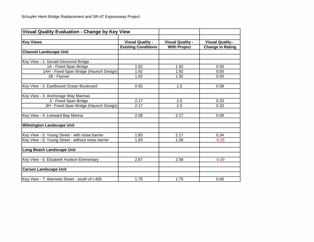
Schuyler Heim Bridge Replacement and SR-47 Expressway Project
Visual Quality Evaluation - Change by Key View
Key Views Visual Quality - Visual Quality - Visual Quality - Existing Conditions With Project Change in Rating
Channel Landscape Unit
Key View - 1: Gerald Desmond Bridge1A - Fixed-Span Bridge 1.92 1.92 0.00
1AH - Fixed-Span Bridge (Haunch Design) 1.92 1.92 0.001B - Flyover 1.92 1.92 0.00
Key View - 2: Eastbound Ocean Boulevard 0.92 1.5 0.58
Key View - 3: Anchorage Way Marinas3 - Fixed-Span Bridge 2.17 2.5 0.33
3H - Fixed-Span Bridge (Haunch Design) 2.17 2.5 0.33
Key View - 4: Leeward Bay Marina 2.08 2.17 0.09
Wilmington Landscape Unit
Key View - 5: Young Street - with noise barrier 1.83 2.17 0.34Key View - 5: Young Street - without noise barrier 1.83 1.58 -0.25
Long Beach Landscape Unit
Key View - 6: Elizabeth Hudson Elementary 2.67 2.58 -0.09
Carson Landscape Unit
Key View - 7: Alameda Street - south of I-405 1.75 1.75 0.00


ES022007003SCO/LW2459.DOC/070400007
Appendix B3 Visual Quality Evaluation Change by Alternative


Schuyler Heim Bridge Replacement and SR-47 Expressway Project
Visual Quality Evaluation - Change by Alternative
Key Views Alternative 1 Alternative 1A Alternative 2 Alternative 3 Alternative 4
Schuyler Heim Bridge
Replacement and SR-47
Expressway
Schuyler Heim Bridge
Replacement (Haunch Design)
and SR-47 Expressway
SR-103 Extension to
Alameda Street
Bridge Avoidance – Section 4(f)
Bridge Replacement
OnlyChannel Landscape UnitKey View - 1: Gerald Desmond Bridge
1A - Fixed-Span Bridge 0.00 0.00 0.00 0.00 0.001AH - Fixed-Span Bridge (Haunch Design) 0.00 0.00 0.00 0.00 0.00
1B - Flyover 0.00 0.00 0.00 0.00 NA
Key View - 2: Eastbound Ocean Boulevard 0.58 0.58 0.58 0.58 NA
Key View - 3: Anchorage Way Marinas3 - Fixed-Span Bridge 0.33 0.33 0.33 0.33 0.33
3H - Fixed-Span Bridge (Haunch Design) 0.33 0.33 0.33 0.33 0.33
Key View - 4: Leeward Bay Marina 0.09 0.09 NA 0.09 NA
Wilmington Landscape Unit
Key View - 5: Young Street - with noise barrier 0.34 0.34 NA 0.34 NAKey View - 5: Young Street - without noise barrier 0.34 0.34 NA -0.25 NA
Long Beach Landscape Unit
Key View - 6: Elizabeth Hudson Elementary NA NA - 0.09 NA NA
Carson Landscape Unit
Key View - 7: Alameda Street - south of I-405 NA NA 0.00 NA NA
NA = not applicable to the specific alternative


ES022007003SCO/LW2459.DOC/070400007
Appendix C Figures


I-710
I-405
SR-103
223rdSt
Alameda St
Wilmington AveSepulvedaB
lvd
Willow
St
Anaheim
St
Ocean
Blvd
PacificC
oastHw
y
SR-47
Wardlow
Rd
Henry Ford Ave
Schuyler HeimBridge
Pier S of Portof Long Beach
I-110
SeasideAve
PacificC
oastHw
y
Anaheim
St
Harry
Bridges
Ave
Navy Way
W.H
il lSt
LEGENDAlternative 1: Bridge Replacement and SR-47 Expressway
Alternative 2: SR-103 Extension
Alternative 3: Bridge Avoidance
Alternative 4: Bridge Replacement Only
Wardlow Road/223rd Street Ramp
Ocean Boulevard/SR-47 Flyover
Existing SR-103 0 1,000Meters
!°(
0 2,800Feet
Aerial Date: May 2002 \\ g a l t \ p r o j \A l a m e d a C o r r i d o r E n g \ 3 2 0 2 6 5 \ M a p F il e s \1 1 x 1 7 L _ a c e t _ o v e r v i e w _ v 1 . m x d 2 / 1 / 2 0 0 7 Note: Project components not to scale
Consolidated Slip
Cerritos C
hannel
Anchorage Way
Marinas
LeewardBay
Marina
CARSONLANDSCAPE
UNIT
ES022077003SCO320265.P2.03.01 TS_Figure 1 Location Map, Build Alternatives, Landscape Units, and View Points.ai 2/07
Figure 1Location Map, Build Alternatives,Landscape Units, and Key ViewpointsSchuyler Heim Bridge Replacement and SR-47 Expressway Project
Landscape Units
Key Viewpoint
General Photo Direction
K-1
K-7
K-6
K-5K-4
K-3
K-2
K-1aK-1b
LONG BEACHLANDSCAPE
UNIT
WILMINGTONLANDSCAPE
UNIT
CHANNELLANDSCAPE
UNIT
Elizabeth Hudson
Elementary School
HudsonPark
Gerald DesmondBridge


ES022077003SCO320265.P2.03.01 TS_Figure 2 Key View 1a (Gerald Desmond Bridge) - Fixed-Span Bridge.ai 2/07
Key View 1: Existing Gerald Desmond View - looking west toward Schuyler Heim Bridge
Key View 1: Simulation of Gerald Desmond Bridge View of fixed-span bridge - looking west toward Schuyler Heim Bridge
Figure 2Key View 1a (Gerald Desmond Bridge) - Fixed-Span BridgeSchuyler Heim Bridge Replacementand SR-47 Expressway Project
CerritosChannel
SR-47SR-47
Badger AvenueBridge
Badger AvenueBridge
CerritosChannel
SR-47SR-47Schuyler Heim
BridgeSchuyler Heim
Bridge


ES022077003SCO320265.P2.03.01 TS_Figure 3 Key View 1a (Gerald Desmond Bridge) - Fixed-Span Bridge (Haunch Design).ai 2/07
Key View 1: Existing Gerald Desmond View - looking west toward Schuyler Heim Bridge
Key View 1: Simulation of Gerald Desmond Bridge View of fixed-span bridge (haunch design) - looking west toward Schuyler Heim Bridge
Figure 3Key View 1a (Gerald Desmond Bridge) - Fixed-Span Bridge (Haunch Design)Schuyler Heim Bridge Replacementand SR-47 Expressway Project
Badger AvenueBridge
CerritosChannel
SR-47Schuyler Heim
Bridge


ES022077003SCO320265.P2.03.01 TS_Figure 4 Key View 1b (Gerald Desmond Bridge) - Flyover.ai 2/07
Key View 1: Existing Gerald Desmond Bridge View - looking southwest toward Schuyler Heim Bridge
Key View 1: Simulation of Gerald Desmond Bridge View - looking southwest toward Schuyler Heim Bridge
Figure 4Key View 1b (Gerald Desmond Bridge) - FlyoverSchuyler Heim Bridge Replacementand SR-47 Expressway Project


ES022077003SCO320265.P2.03.01 TS_Figure 5 Key View 2 (Eastbound Ocean Boulevard) - Flyover.ai 2/07
Key View 2: Existing Ocean Boulevard - looking northeast
Key View 2: Simulation of Ocean Boulevard - looking northeast
Figure 5Key View 2 (Eastbound Ocean Boulevard) - FlyoverSchuyler Heim Bridge Replacementand SR-47 Expressway Project


ES022077003SCO320265.P2.03.01 TS_Figure 6 Key View 3 (Anchorage Way Marinas) - Fixed-Span Bridge.ai 2/07
Key View 3: Existing Anchorage Way Marinas View - looking northeast toward Badger Bridge and Schuyler Heim Bridge
Key View 3: Simulation of Anchorage Way Marinas View of fixed-span bridge - looking northeast toward Badger Bridge and Schuyler Heim Bridge
Figure 6Key View 3 (Anchorage Way Marinas) - Fixed-Span BridgeSchuyler Heim Bridge Replacementand SR-47 Expressway Project


ES022077003SCO320265.P2.03.01 TS_Figure 7 Key View 3 (Anchorage Way Marinas) - Fixed-Span Bridge (Haunch Design).ai 2/07
Key View 3: Existing Anchorage Way Marinas View - looking northeast toward Badger Bridge and Schuyler Heim Bridge
Key View 3: Simulation of Anchorage Way Marinas View of fixed-span bridge (haunch design) - looking northeast toward Badger Bridge and Schuyler Heim Bridge
Figure 7Key View 3 (Anchorage Way Marinas) - Fixed-Span Bridge (Haunch Design)Schuyler Heim Bridge Replacementand SR-47 Expressway Project

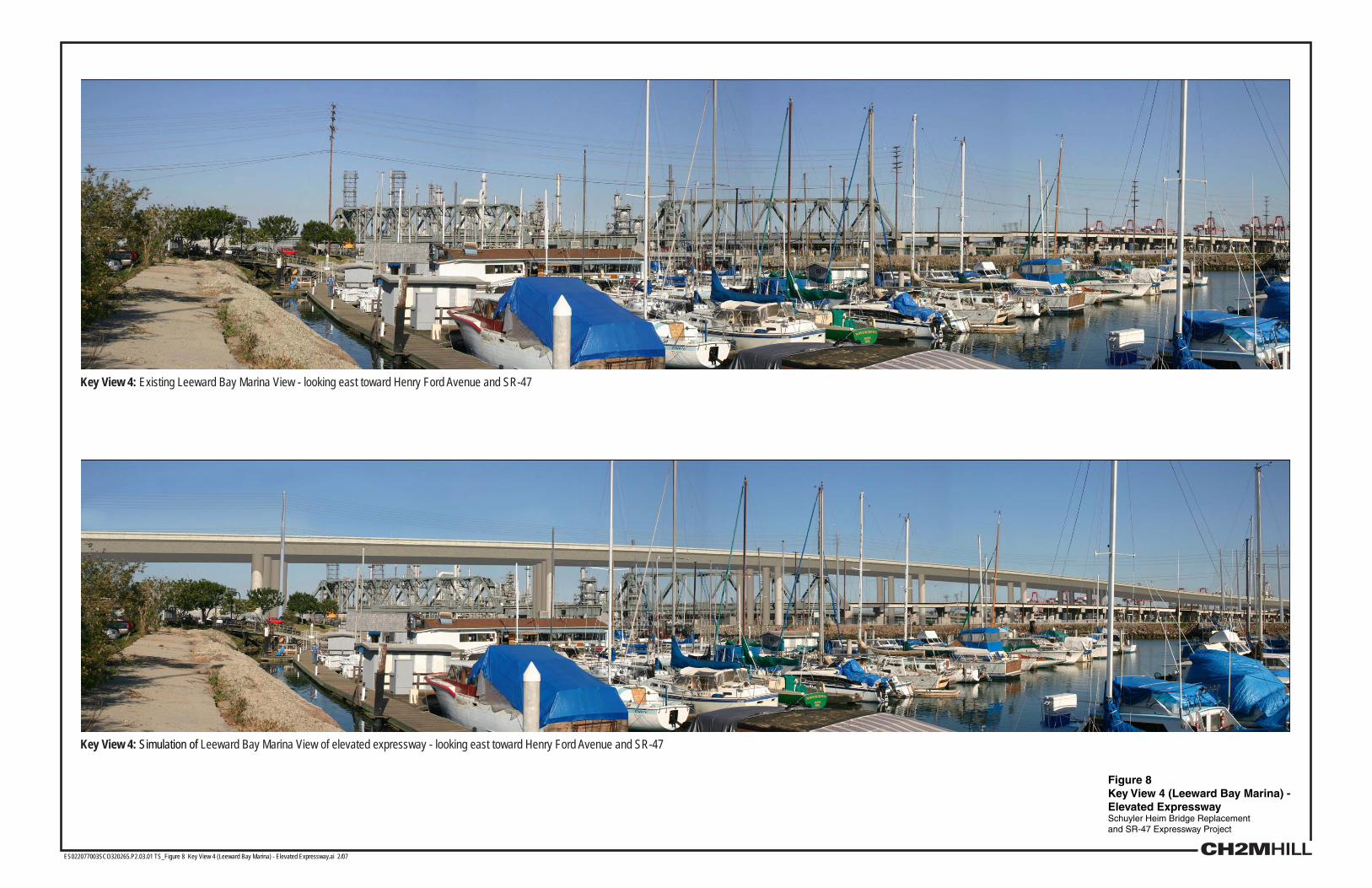
ES022077003SCO320265.P2.03.01 TS_Figure 8 Key View 4 (Leeward Bay Marina) - Elevated Expressway.ai 2/07
Key View 4: Existing Leeward Bay Marina View - looking east toward Henry Ford Avenue and SR-47
Key View 4: Simulation of Leeward Bay Marina View of elevated expressway - looking east toward Henry Ford Avenue and SR-47
Figure 8Key View 4 (Leeward Bay Marina) - Elevated ExpresswaySchuyler Heim Bridge Replacementand SR-47 Expressway Project


ES022077003SCO320265.P2.03.01 Vis_Figure 9a Key View 5 (Young Street) - Elevated Expressway.ai 5/07
Key View 5: Existing Young Street View - looking east toward Henry Ford Avenue
Key View 5: Simulation of Young Street View of elevated expressway - looking east toward Henry Ford Avenue
Figure 9aKey View 5 (Young Street) - Elevated ExpresswaySchuyler Heim Bridge Replacementand SR-47 Expressway Project


ES022077003SCO320265.P2.03.01 Vis_Figure 9b Key View 5 (Young Street) - Elevated Expressway.ai 5/07
Key View 5: Existing Young Street View - looking east toward Henry Ford Avenue
Key View 5: Simulation of Young Street View of elevated expressway and sound walls - looking east toward Henry Ford Avenue
Figure 9bKey View 5 (Young Street) - Elevated ExpresswaySchuyler Heim Bridge Replacementand SR-47 Expressway Project


ES022077003SCO320265.P2.03.01 VIS_Figure 10 Key View 6 (Hudson Elementary School) - SR-103 Extension.ai 5/07
Key View 6: Existing Hudson School View - looking northwest toward SR-103
Key View 6: Simulation of Hudson School View of the elevated expressway and sound walls - looking northwest toward SR-103
Figure 10Key View 6 (Hudson Elementary School) - SR-103 ExtensionSchuyler Heim Bridge Replacementand SR-47 Expressway Project


ES022077003SCO320265.P2.03.01 TS_Figure 11 Key View 7 (Alameda Street South of I-405) - SR-103 Extension.ai 2/07
Key View 7: Existing Alameda Street View - looking approximately south along the Alameda Transportation Corridor just south of I-405
Key View 7: Simulation of Alameda Street View of SR-103 Extension - looking approximately south along the Alameda Transportation Corridor just south of I-405
Figure 11Key View 7 (Alameda Street South of I-405) - SR-103 ExtensionSchuyler Heim Bridge Replacementand SR-47 Expressway Project


ES022007003SCO/LW2459.DOC/070400007
Appendix D Cumulative Projects


ES022007003SCO/LW2459.DOC/070400007 D-1
Appendix D – Cumulative Projects
DRAFT
Planned/Proposed Transportation Improvement Projects in Port Study Area (8/8/05)
Port Area Projects
Project Description/Status Estimated Completion Date
Harbor Boulevard/ Swinford Street
Add dual left turns northbound – EIR mitigation for Cabrillo Marina Ph. II
Currently being studied as part of West Basin Improvement
Figueroa Street/ C Street Reconstruction Currently being studied as part of West Basin Improvement
Harry Bridges Boulevard Realignment – pending further review Only realigned at C Street
Port ATMIS First phase ATMIS deployment
I-110/ Swinford/ Harbor/SR-47
Phase I and II improvements to interchange Currently being studied as part of West Basin Improvement
Navy Way/Seaside Flyover Flyover of northbound lefts, eliminate traffic signal On hold
Vincent Thomas Bridge Parallel facility
LA MTA Short Range Transportation Plan for LA County
Project Description/Status Estimated Completion Date
Avalon Blvd at I-405 Freeway [1]
Reconfigure interchange to meet future traffic loads; widen NB off-ramp at Avalon
2005
Artesia on-ramp at I-405 Modify the NB on-ramp at Artesia by adding a third lane
Wilmington at I-405 [1] Widen the SB off-ramp at Wilmington to two lanes and widen the intersection at off-ramp and Wilmington
2005
Avalon Blvd at I-405 [1] Modify the SB on-ramp at Avalon Blvd at I-405 2005
Downtown/Shoreline Drive Adaptive Traffic Management System
Deployment of ITS elements in the Long Beach downtown area to provide an adaptive traffic management system to respond to special generator traffic

APPENDIX D – CUMULATIVE PROJECTS
D-2 ES022007003SCO/LW2459.DOC/070400007
LA MTA Short Range Transportation Plan for LA County
Project Description/Status Estimated Completion Date
Pier B St Intermodal Railyard Expansion [1]
Expansion of the Pier B St Intermodal Railyard (including realignment/widening of Pier B St) to facilitate additional volume of rail shipments to and from the Port of Long Beach
04/30/08
Pacific Coast Highway Widen PCH from Terminal Island Freeway to Cherry Ave
Willow Street Widen Willow St from Terminal Island Freeway to Cherry Ave
Ocean Boulevard Widen Ocean Blvd from Terminal Island Freeway to Harbor Scenic Drive (excluding Gerald Desmond Bridge)
Gerald Desmond Bridge [1] Replace Gerald Desmond Bridge
I-710 Freeway Add truck lanes from I-405 to I-10 Freeway
SR-91/I-710 Freeways Reconstruct SR-91/I-710 interchange to improve geometric to standard
I-405/I-710 Freeways Reconstruct interchange at I-405/I-710 to improve geometric to standard and eliminate weaving
[1] Project also appears in the Draft 2004 SCAG Regional Transportation Plan
2004 SCAG Regional Transportation Plan
Project Description/Status Estimated Completion Date
Baseline Projects
I-710 Corridor Study Corridor study between the SR-60 and the Port of Long Beach and Los Angeles
Alameda Street Widening Widen Alameda Street from Del Amo Boulevard to SR-91 from 4 to 6 lanes, construct grade separation
Alameda Corridor Study Determine feasibility of utilizing corridor as a by-pass route for HOVs and trucks, and an analysis of the I-110 for enhanced goods movement
Alameda Street Widening Widen Alameda Street from PCH to Henry Ford Ave from 4 to 6 lanes
Henry Ford Ave Rehabilitation
From Alameda Street to Anaheim Street widen existing turn lanes
Anaheim Street Widening From Farragut Ave to Dominguez Channel, the project will widen from 4 to 6 lanes and upgrade the highway to major highway standards
Sepulveda Blvd/I-105 Westbound Off-ramp
Widen northbound Sepulveda from 1 to 2 lanes and add a westbound exit lane
Gerald Desmond Bridge Replacement
Replace existing bridge

APPENDIX D – CUMULATIVE PROJECTS
ES022007003SCO/LW2459.DOC/070400007 D-3
2004 SCAG Regional Transportation Plan
Project Description/Status Estimated Completion Date
Terminal Island Freeway/ Ocean Boulevard Interchange
A new grade separated interchange is planned that would eliminate all conflicts for east/west “through” traffic movements on Ocean Boulevard. Through traffic will be separated on an arterial viaduct structure and will not be forced to stop for red signals.
Ports of Long Beach and Los Angeles ATMS/ATIS
Add up to 16 closed circuit TV cameras and 9 interchangeable signs to improve traffic operations on the I-710 and I-110
Water Street/Figueroa Street/Fries Avenue
New 4-lane roadway
Mormon Island Access Grade Separation
Grade separation at the rail road crossing
Tier 2 Projects
Henry Ford Ave Intersection of Henry Ford Ave with terminal access road and Terminal Island Freeway ramps intersection improvements
Alameda Corridor Truck Expressway
Extend 1.7 miles, a new 4-lane expressway from Commodore Schuyler Heim Bridge and Alameda Street
Henry Ford Widening Widen Henry Ford Ave from 4 to 6 lanes from Anaheim Street to SR-47 Freeway
Pier B Intermodal Railyard Expansion
Project will expand Pier B St intermodal railyard to facilitate additional rail shipments and realign and widen Pier B St
Harry Bridges Boulevard Relocation/consolidation of streets intersections, traffic channelization, and signalization
Plan Projects
I-105 Freeway Interchange improvements at Alameda St
I-110 Freeway Interchange improvements at Capitol Dr, Gaffey St/Pacific Ave, PCH, and Torrance Blvd
I-110, SR-47, Harbor Blvd Ramps
Interchange realignment and widening
I-405 Freeway at Avalon Blvd
Construct new SB on-ramp in southeast quadrant of interchange
I-405 at Del Amo Interchange/Ramps
Navy Way connector ramp to Seaside (SR-47)
Provide a 2 lane connector ramp for NB Navy Way to WB Seaside Ave
Pier B St/Terminal Island Freeway
Interchange improvement – new NB on-ramp to Terminal Island Freeway
SR-103 at Anaheim St Interchange improvements

APPENDIX D – CUMULATIVE PROJECTS
D-4 ES022007003SCO/LW2459.DOC/070400007
2004 SCAG Regional Transportation Plan
Project Description/Status Estimated Completion Date
I-710 Corridor between Alameda/Wilmington and Lakewood Blvd
From Ports of Los Angeles and Long Beach to the SR-60 widen various arterials to 6 lanes
Wilmington Ave From 223rd St to I-405, add 1 lane to NB Wilmington and widen I-405 SB on-ramp to 2 lanes
B Street Realignment Rail alignment along Harry Bridges new alignment
West Basin Railyard Expansion
Expand rail yard
Avalon Boulevard A Street to Water Street, provide 1- or 2-lane grade separation
Mormon Island Access Grade Separation
Harry Bridges Blvd to Fries Ave, provide 1- or 2-lane grade separation
I-110 Freeway HOV HOV lanes from I-405 to SR-91
Other Unconstrained Projects
SR-91/I-110 Freeway From east to south and east to north, provide HOV connectors
Unknown
I-710 Freeway At Wardlow Road, reconstruct connector bridge Unknown
[1] Project also appears in the Draft 2004 SCAG Regional Transportation Plan
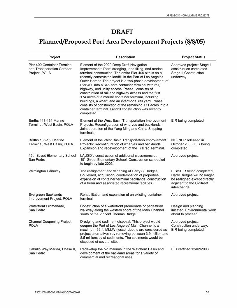
APPENDIX D – CUMULATIVE PROJECTS
ES022007003SCO/LW2459.DOC/070400007 D-5
DRAFT
Planned/Proposed Port Area Development Projects (8/8/05)
Project Description Project Status
Pier 400 Container Terminal and Transportation Corridor Project, POLA
Element of the 2020 Deep Draft Navigation Improvements Plan: dredging, land filling, and marine terminal construction. The entire Pier 400 site is on a recently constructed landfill in the Port of Los Angeles Outer Harbor. The project is a two-phase development of Pier 400 into a 345-acre container terminal with rail, highway, and utility access. Phase I consists of construction of rail and highway access and the first 174 acres of a marine container terminal, including buildings, a wharf, and an intermodal rail yard. Phase II consists of construction of the remaining 171 acres into a container terminal. Landfill construction was recently completed.
Approved project; Stage I construction completed. Stage II Construction underway.
Berths 118-131 Marine Terminal, West Basin, POLA
Element of the West Basin Transportation Improvement Projects: Reconfiguration of wharves and backlands. Joint operation of the Yang Ming and China Shipping terminals.
EIR being completed.
Berths 136-150 Marine Terminal, West Basin, POLA
Element of the West Basin Transportation Improvement Projects: Reconfiguration of wharves and backlands. Expansion and redevelopment of the TraPac Terminal.
NOI/NOP released in October 2003. EIR being completed.
15th Street Elementary School San Pedro
LAUSD’s construction of additional classrooms at 15th Street Elementary School. Construction scheduled to begin by late 2003.
Approved project.
Wilmington Parkway The realignment and widening of Harry S. Bridges Boulevard, acquisition/ condemnation of properties, expansion of container terminal backlands, construction of a berm and associated recreational facilities.
EIS/SEIR being completed. Harry Bridges will no longer be realigned except directly adjacent to the C-Street interchange.
Evergreen Backlands Improvement Project, POLA
Rehabilitation and expansion of an existing container terminal.
Approved project.
Waterfront Promenade, San Pedro
Construction of a waterfront promenade or pedestrian walkway along the western shore of the Main Channel south of the Vincent Thomas Bridge.
Design and planning initiated. Environmental work about to proceed.
Channel Deepening Project, POLA
Dredging and sediment disposal. This project would deepen the Port of Los Angeles’ Main Channel to a maximum-55 ft. MLLW (lesser depths are considered as project alternatives) by removing between 3.9 million and 8.5 millions cy of sediments. The sediments would be disposed of several sites.
Approved project; Construction underway. EIR being completed.
Cabrillo Way Marina, Phase II, San Pedro
Redevelop the old marinas in the Watchorn Basin and development of the backland areas for a variety of commercial and recreational uses.
EIR certified 12/02/2003.

APPENDIX D – CUMULATIVE PROJECTS
D-6 ES022007003SCO/LW2459.DOC/070400007
Project Description Project Status
Piers D/E/F Terminal Redevelopment, POLB
Expansion of an existing marine container terminal. The Piers D, E, and F Development project will be located in the Middle Harbor area of the Port. The project will involve consolidation of two existing container terminals into one 336-acre terminal. Construction will include approximately 53 acres of landfill, dredging, wharf construction, construction of an intermodal rail yard, and reconstruction of terminal operations buildings.
Approved project; Construction pending.
Piers G & J Terminal Redevelopment Project, POLB
Redevelopment of two existing marine container terminals into one terminal. The Piers G and J redevelopment project is in the Southeast Harbor Planning District area of the Port. The project will develop a marine terminal of up to 315 acres by consolidating two existing terminals on Piers G and J and several surrounding parcels. Construction is now under way and will occur in four phases and include approximately 53 acres of landfills, dredging, concrete wharves, rock dikes, and road and railway improvements.
Approved project; Construction underway.
Pier A Expansion Project, POLB Expansion of an existing marine container terminal. The Pier expansion project would be located north of Cerritos Channel on both sides of the Terminal Island Freeway in the Port. The project consists of the development of approximately 90 acres of oil production land, including remediation of soil and groundwater contamination, relocation of oil wells, filling, paving, and utilities. Additionally, an underpass linking the existing Pier A site to the expansion site would need to be constructed under the Terminal Island Freeway, just north of the Commodore Schuyler F. Heim Bridge. This project is in the conceptual stage, and no environmental documentation has been prepared by the Port.
Conceptual project.
Hanjin Terminal Pier T, POLB Development of a container terminal, liquid bulk facility, and satellite launch facility. The Port is redeveloping the former Long Beach Naval Complex on Terminal Island. The project consists of constructing a 300-acre marine container, which includes a wharf, terminal operations buildings, utilities, and rail yard. Construction includes 22 acres of landfill. The project also includes a ship repair facility, liquid bulk facility, expansion of existing break-bulk facilities, and satellite processing facility already built on the former Navy Mole.
Approved project; Phase I complete, Phase II under construction.
Pier S Marine Terminal, POLB Development of a 150-acre container terminal. The Pier S site is in the Port on Terminal Island and encompasses approximately 170 acres of former oil production land, which is currently undergoing remedial action. Following remediation and stabilization, the site will be brought up to grade and paved for use as a marine container terminal. The project calls for the existing riprap dike along Cerritos Channel to be realigned and a concrete, pile-supported wharf to be built. Additionally, terminal buildings, utilities, and a rail yard will be constructed.
Approved project; Construction underway. EIR in review.
Long Beach LNG Terminal, POLB
Construction of a liquefied natural gas (LNG) import terminal facility on a portion of Pier T on Terminal Island within the Port of Long Beach.
EIR in review.

APPENDIX D – CUMULATIVE PROJECTS
ES022007003SCO/LW2459.DOC/070400007 D-7
Project Description Project Status
RMS Queen Mary Seaport, City/POLB
Construction of a variety of retail and entertainment uses and parking. The Queen Mary Seaport project is a 54-acre, phased development adjacent to and incorporating the Queen Mary in the Port. Phase I includes onboard upgrades to the Queen Mary and surface parking improvements. Phase II includes construction of retail and entertainment-based uses, a parking structure, a hotel, and new infrastructure. Phase III includes events, park improvements, a major attraction, and additional retail and restaurant uses.
Approved project; Construction underway
Fishing Reef, San Pedro Breakwater, POLA
Development of an artificial reef site south of the San Pedro Breakwater. Provides opportunity for suitable reuse of clean construction materials, and to create bottom topography to promote local sport fishing.
Negative Declaration issued and certified.
Evergreen Expansion, Terminal Island, POLA
Expansion of the Evergreen Marine Terminal. Lease boundary changes, gate improvements, wharf modifications, cranes, and new buildings.
EIR to be prepared. NOP for new EIR release possible in January 2004.
Berths 97-109 Container Terminal Project, West Basin, POLA
Development and operation of a container terminal at Berths 97-109.
EIR being completed.
Charter High School, San Pedro, POLA
Proposal to develop a Charter High School “Port of Los Angeles High School of International Business and Maritime Studies.”
EIR to be prepared. NOP for EIR release possible in January 2004.
Port Police Station, San Pedro, POLA
Development of a new headquarters building for the Port Police.
EIR to be prepared. NOP for EIR release possible in January 2004. May be combined with Charter School.
SSA Outer Harbor Fruit Facility Relocation, POLA
Proposal to relocate the existing fruit import facility at 22nd and Miner to Berth 153.
EIR to be prepared.
Crescent Warehouse Company Relocation, POLA
Relocate the operations of Crescent Warehouse Company from Port Warehouses 1, 6, 9, and 10. Southeast Wilmington along Henry Ford and East I Street (tentative).
EIR to be prepared. NOP for EIR release possible in January 2004.
Pasha Marine Terminal Improvements EIR, Berths 171-181, POLA
Redevelopment of existing facilities at Berths 171-181 as an Omni (multi-use) facility.
Draft EIR scheduled for release in June 2004.
Pacific Energy Systems, Pier 400, POLA
Proposal to construct a Crude Oil Receiving Facility on Pier 400 with tanks on Terminal Island as well as pipelines between berth, tanks, and pipeline system.
New Project EIR to be prepared.
Berths 206-209 Interim Reuse EIR, Berths 206-209, POLA
Proposal to allow interim reuse of former Matson Terminal. Change in tenant, no substantial change in operations.
New Project EIR to be prepared. NOP released for public review in October 2003.
Ultramar, Valero Lease Renewal, POLA
Lease renewal EIR for liquid bulk (petroleum) terminal. New Project EIR to be prepared.
Conoco-Phillips Marine Oil Terminal, POLA
Lease renewal EIR for marine oil terminal. New Project EIR to be prepared.

APPENDIX D – CUMULATIVE PROJECTS
D-8 ES022007003SCO/LW2459.DOC/070400007
Project Description Project Status
Marriott Hotel Project, City of Long Beach
Development of a hotel. The Marriott Hotel project is a 430-room hotel on the southeast corner of Ocean Boulevard and the Promenade. This City of Long Beach project is currently awaiting approvals from the City of Long Beach.
Approved, construction underway.
D’Orsay Hotel, City of Long Beach
Development of a hotel. The D’Orsay Hotel project is a 162-room boutique style hotel on the northwest corner of Broadway and the Promenade. This project is currently awaiting City of Long Beach approval.
Approved, construction underway.
Long Beach Plaza Mall Redevelopment, City of Long Beach
Development of commercial and residential space. The former Long Beach Plaza Mall, downtown between Third and Sixth Streets, between Long Beach Boulevard and Pacific Avenue, is now under construction. The approved project will redevelop the former mall area and two blocks of vacant land east of Long Beach Boulevard with approximately 450,000 square feet of commercial space and up to 200 residential units.
Approved, construction underway.
Pike Property Development, City of Long Beach
Development of residential units and an office building or hotel. This project site is south of Ocean Boulevard on the site of the former Pike Amusement Park between Pine and Magnolia Avenues in Long Beach. This approved project is now under construction and will include approximately 770 residential units, a 500-room hotel, and 25,000 square feet of commercial space.
Approved, construction underway.
Queensway Bay Master Plan, City of Long Beach
Construction of Long Beach Aquarium, new urban harbor, office building, and entertainment complex. This project, designed to create a major waterfront attraction in downtown Long Beach, includes a recreational harbor, 150,000-square-foot aquarium, 125,000-square-foot entertainment complex, 59,000 square feet of restaurant/retail space, an 800-room hotel, 95,000 square feet of commercial/office space, and 487 boat slips in and around Queensway Bay. The recreational harbor and aquarium have been completed.
Approved, construction underway.
Fisherman’s Village, San Pedro Relocation of restaurant and fish market from Ports O’ Call; new retail; pedestrian promenade.
Planning and preliminary design.
Pacific Corridor Redevelopment Project, San Pedro
Development of commercial/retail, manufacturing, and residential components.
Studies completed.
Cabrillo Marine Aquarium Expansion, San Pedro
Expansion of existing Cabrillo Marine Aquarium. Construction underway.
East Wilmington Greenbelt Community Center
Construction of a new 10,000-square-foot community building, a 25-space parking lot, and landscaped areas.
Project approved, construction to begin in April 2004.
Gerald Desmond Bridge Replacement Project, Port of Long Beach
Replacement of the existing Gerald Desmond highway bridge over the Port of Long Beach Back Channel with a new highway bridge.
Conceptual Design.

APPENDIX D – CUMULATIVE PROJECTS
ES022007003SCO/LW2459.DOC/070400007 D-9
Project Description Project Status
Night Club/Sports Bar, San Pedro
Mt. Sinai Missionary Baptist Church, San Pedro
Demolish existing and construction 14,800-square-foot church
Regal Theater, San Pedro Newspaper article states that this project will not continue.
Gas Station & Minimart, San Pedro
6-pump gas station and 1,390-square-foot mini-mart.