Embed Size (px)
Citation preview

VDOT Appraisal Guide Page 1 Revised August 25, 2011
Appraisal Guide This guide has been developed to provide greater depth and direction to both the new appraiser and the experienced appraiser in the area of eminent domain appraising. It provides discussion and examples of appraisal issues that may be encountered when appraising for eminent domain purposes as opposed to lending or for other purposes. In addition, Appendices are attached that provide a glossary of terms specific to eminent domain and also a brief overview about how to read highway plans and what information is pertinent to note from an appraiser’s perspective. In addition to the plan reading overview provided in the Appendices, additional information can be found by clicking on the following link: http://www.virginiadot.org/business/locdes/training-planreading.asp It should be noted that information provided in this guide does not set forth policy. The information is presented to assist the appraiser with evaluating and solving common issues that may surface in eminent domain appraising. The appraiser should refer to Chapter 4 of VDOT’s Right of Way and Utilities Manual to review VDOT’s appraisal policies. If the appraiser has any questions regarding a specific issue that this guide may not address, or the appraiser requires clarification of a topic presented within this guide, they should contact the Assistant Right of Way Manager in charge of appraisal in the district office. Comments and suggestions for improving the Appraisal Guide are welcomed and they may be directed to the Chief Appraiser (central office) or the Review Appraiser (district office).
VDOT Appraisal Guide Page 2 Revised August 25, 2011
APPRAISAL GUIDE TABLE OF CONTENTS 1. TOTAL VERSUS PARTIAL ACQUISITION OVERVIEW ....................................................................... 3
2. TOTAL VERSUS PARTIAL ACQUISITIONS APPRAISAL REPORTING REQUIREMENTS .......... 3
3. UNIFORM RELOCATION ASSISTANCE AND REAL PROPERTY ACQUISITION POLICIES ACT OF 1970 (“THE UNIFORM ACT”) ....................................................................................................... 3
4. HIGHLIGHTED APPRAISAL TOPICS RESULTING FROM THE UNIFORM ACT ........................... 5
5. THE VALUATION PROCESS AND VDOT ................................................................................................. 7
6. VDOT AND SCOPE OF THE APPRAISAL ................................................................................................. 8
7. EMINENT DOMAIN AND HIGHEST AND BEST USE CONSIDERATIONS ........................................ 8
8. CONFIRMATION OF DATA FOR COMPARABLE SALES .................................................................. 12
9. SALES COMPARISON ADJUSTMENTS ................................................................................................... 12
10. RECONCILIATION OF VALUE ................................................................................................................. 16
11. EASEMENTS .................................................................................................................................................. 17
12. ENHANCEMENTS: GENERAL VS. SPECIAL / PECULIAR BENEFITS ............................................. 23
13. TYPES OF DAMAGES .................................................................................................................................. 23
14. COST TO CURE DAMAGES ....................................................................................................................... 25
15. APPRAISING REMAINDER PARCELS .................................................................................................... 27
16. TOTAL ACQUISITION WITH AN UNECONOMIC REMNANT .......................................................... 28
17. EXCESS LAND VS. SURPLUS LAND ........................................................................................................ 28
18. APPRAISING ON-PREMISE OR NON-PERMITTED SIGNS ................................................................ 29
19. OUTDOOR ADVERTISING SIGNS ............................................................................................................ 30
20. PRIMARY VS. SECONDARY DATA SOURCES AND INCORPORATING INFORMATION FROM OTHER REPORTS ........................................................................................................................................ 31
21. REVISED AND UPDATED APPRAISALS ................................................................................................. 31
22. DATA OWNERSHIP ..................................................................................................................................... 31
23. INTERIM USE ................................................................................................................................................ 32
24. MISPLACED IMPROVEMENT .................................................................................................................. 33
VDOT Appraisal Guide Page 3 Revised August 25, 2011
1. Total versus Partial Acquisition Overview
When acquiring Right of Way, VDOT may elect to acquire the property owner’s entire property which is referred to as a “Total Acquisition”. However, the vast majority of acquisitions made by VDOT are “Partial Acquisitions” where only a portion of a property is acquired. The appraisal of a “Partial Acquisition” consists of three potential components. First, the value of the property is estimated prior to the acquisition (irrespective of project influence). This is called the “before value”. The second step is for the appraiser to estimate the value of the portion of the property to be acquired. Once a “Partial Acquisition” is completed, the remaining property is referred to as the “Remainder”. The appraiser must then determine if the Remainder property has experienced any positive influences (“enhancements”) and/or compensable negative influences (“damages”) resulting from the partial acquisition and/or the proposed roadway improvements. This value is referred to as the “after value”. If the net result is a loss of value to the Remainder, the results are incorporated in the “after value”.
2. Total versus Partial Acquisitions Appraisal Reporting Requirements
VDOT’s appraisal reports include three basic formats: Land, Residential and Commercial property acquisition. Each is designed to expand when necessary to address the appraisal problem, e.g., damages and/or enhancement (). When the appraisal is being completed for a “Total Acquisition” or for a “Partial Acquisition where no damages are estimated to the “Remainder”, an “after value” is not required. When the appraiser determines that the net effect of a “Partial Acquisition” and the proposed roadway improvements result in compensable damages to the Remainder, the appraiser must report an “after value” for the Remainder. In this case, the resulting appraisal will expand to create a section that includes an “after value” estimate as well as an opinion of just compensation reflecting any damages or enhancements in addition to the value of the acquisition.
3. Uniform Relocation Assistance and Real Property Acquisition Policies Act of 1970 (“the Uniform Act”)
The Federal legislation that sets Federal acquisition appraisal standards is the Uniform Relocation Assistance and Real Property Acquisition Policies Act of 1970, Public Law 91-646, (the Uniform Act) specifically Sections 301 and 302 (42 U.S.C. §4651 and §4652), as amended by Public Law 100-17, Uniform Relocation Act Amendments of 1987, Title IV. A copy of the Uniform Relocation Act is located at: http://www.fhwa.dot.gov/realestate/act.htm. Regulations implementing appraisal standards of the Uniform Act are found in 49 Code of Federal Regulations Part 24 and can be accessed at: http://www.fhwa.dot.gov/REALESTATE/ua/index.htm .
VDOT Appraisal Guide Page 4 Revised August 25, 2011
BACKGROUND
The Uniform Relocation Act of 1970 (“the Uniform Act”) was enacted January 2, l971, and amended several times. The most recent amendment took place in 2005 and copy of the amendment is located at the following link: http://www.fhwa.dot.gov/realestate/UAfnl99.htm.
The Uniform Act was intended to establish a uniform policy for the fair and equitable treatment of persons who are displaced as a direct result of programs or projects that are undertaken by a federal agency or with federal financial assistance. It ensures that displaced persons shall not suffer disproportionate injuries as the result of programs and projects designed for the benefit of the public as a whole and minimizes the hardship of displacement on such persons. Also it establishes minimum real property acquisition policies, standards and requirements for appraisal, negotiation, and property possession.
ISSUE
Appraisers who complete an appraisal for the Virginia Department of Transportation (VDOT) must comply with the Uniform Act. The Right of Way and Utilities Manual, Volume I, Chapter 4, Appraisal, incorporates the Uniform Act into VDOT appraisal policy. Prior to completing an appraisal for VDOT, the appraiser is required to read and review Chapter 4 of the Right of Way and Utilities Manual so that they can have an understanding of what VDOT appraisal policy requires in order to comply with the Uniform Act. In addition, they may also review the Uniform Act and its accompanying regulations for clarification on specific appraisal issues. It should be noted that the act makes reference to the Uniform Appraisal Standards for Federal Land Acquisitions (UASFLA) which is considered to be an extension of the Uniform Standards of Professional Appraisal Practice (USPAP). UASFLA is specifically designed for federal agencies that acquire real property through the use of eminent domain. It is seldom applicable for use by a state agency such as VDOT. The Uniform Act requires that all real property to be acquired must be appraised, but it also authorizes waiving that requirement for low value acquisitions. Regulations provide that the appraisal may be waived: • If the property owner elects to donate the property and release the agency from the
obligation of performing an appraisal or
• If the agency believes the acquisition of your property is uncomplicated and a review of available data supports a fair market value likely to be $10,000 or less, the agency may prepare a waiver valuation, rather than an appraisal, to estimate your fair market value.
When an appraisal is waived, a “waiver” is prepared. VDOT refers to its “waiver” as a Basic Administrative Report (“BAR”). FHWA and the Appraisal Foundation differ on
VDOT Appraisal Guide Page 5 Revised August 25, 2011
their views as to whether or not preparing a “waiver” constitutes an appraisal. Regulations promulgated by the Virginia Real Estate Appraiser Board for Standards of , Professional Practice (see 18 VAC 130-20-180) require that all licensees comply with the provisions of Uniform Standards of Professional Appraisal Practice with respect to the development of an appraisal, appraisal report requirements and the requirements for reviewing an appraisal (see Subsections D-F). However, Subsection A states that “the provisions of Subsections C through J of this section shall not apply to local, state and federal employees performing in their official capacity”. Irrespective, VDOT’s policy is that its licensed staff appraisers comply with the Uniform Standards of Professional Appraisal Practice. Consequently, if a licensed appraiser completes a BAR, it is referenced as a real estate appraisal that is very limited in scope. If a staff member of VDOT completes a BAR, and they are not an appraiser but they are acting in their official capacity as a state employee, the Real Estate Appraiser Regulations do not apply to them. At this time, VDOT does not allow non-government employees, either licensed appraisers or others, to complete a BAR report. SUMMARY
The Uniform Act and state regulations, as they relate to real estate appraisal, are incorporated within VDOT’s appraisal policies set forth in the Right of Way and Utilities Manual, Chapter 4. Chapter 4 sets forth a policy requirement that the appraiser must read and understand prior to completing an appraisal for VDOT. If needed, the appraiser should check with the respective local, state or federal agency for guidance on the Uniform Act. For interpretations on state regulations and policy, the appraiser should contact the Assistant Right of Way and Utilities Manager for appraisal in the appropriate district office.
4. Highlighted Appraisal Topics Resulting from the Uniform Act
Issues that surface relative to the Uniform Act include:
1. “Tenant-Owned” Improvements: When a building, structure or other improvement is acquired or adversely impacted by the acquisition, it will be valued as if owned in fee regardless of any existing lease or tenant ownership. The value of the improvements must be based on their contributory value or their value if removed (salvage value), whichever is greatest. The appraiser shall disregard lease terms that require the tenant to remove buildings, structures, or improvements and appraise them as if they could stay through their usual life as extended by normal maintenance. VDOT does not require that the appraiser place a minimum value on all “tenant owned” improvements if the appraiser concludes that they have no market value or salvage value. When there is agreement as to ownership between the fee owner and the tenant, the tenant’s interest must be separated in the appraisal because the agency must make a separate offer to the tenant for tenant owned buildings, structures, and improvements. When “tenant owned” improvements are present and a value is placed upon them, the

VDOT Appraisal Guide Page 6 Revised August 25, 2011
appraiser is required to report the total property value and then also report the value of property owned by the owner and the value of property owned by the tenant. When tenant owned improvements are present and have value, the appraiser must prepare three separate executive summary reports as a part of their appraisal report that show:
1. Total Property Value 2. Owner Value 3. Tenant Value.
Please note that the appraiser is not required to separate or value the leasehold interest of the tenant(s).
2. Minimum Appraiser Qualifications: Federal and state agencies may have different minimum appraiser qualifications depending upon the government agency in order to comply with the Uniform Act and their respective roles within the government. VDOT outlines its criteria in its Right of Way and Utilities Manual, Volume I, Chapter 4.
3. Project Influence: When completing an appraisal for eminent domain purposes, the appraiser is required to ignore the effects and impact of the proposed project on market value when determining the value of the acquisition. However, doing so is not a jurisdictional exception under USPAP since USPAP states that project influence must only be recognized when it is part of the appraisal assignment. For additional reference, the treatment of project influence is stated in section 25.1-214 of the Code of Virginia. Please note that project influence on market value must be considered when determining the value of any remaining property.
VDOT Appraisal Guide Page 7 Revised August 25, 2011
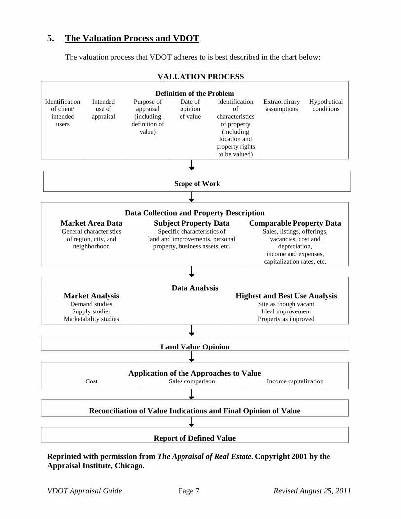
5. The Valuation Process and VDOT
The valuation process that VDOT adheres to is best described in the chart below:
VALUATION PROCESS
Definition of the Problem Identification
of client/ intended
users
Intended use of
appraisal
Purpose of appraisal
(including definition of
value)
Date of opinion of value
Identification of
characteristics of property (including
location and property rights to be valued)
Extraordinary assumptions
Hypothetical conditions
Data Collection and Property Description Market Area Data
General characteristics of region, city, and
neighborhood
Subject Property Data Specific characteristics of
land and improvements, personal property, business assets, etc.
Comparable Property Data Sales, listings, offerings,
vacancies, cost and depreciation,
income and expenses, capitalization rates, etc.
Data Analysis
Market Analysis Demand studies Supply studies
Marketability studies
Highest and Best Use Analysis Site as though vacant Ideal improvement
Property as improved
Application of the Approaches to Value Cost Sales comparison Income capitalization
Reconciliation of Value Indications and Final Opinion of Value
Report of Defined Value Reprinted with permission from The Appraisal of Real Estate. Copyright 2001 by the Appraisal Institute, Chicago.
Scope of Work
Land Value Opinion
VDOT Appraisal Guide Page 8 Revised August 25, 2011
6. VDOT and Scope of the Appraisal
The scope of the appraisal report is intended to define the extent of research completed by the appraiser including the appraiser’s data sources, publications used, etc. Also, the appraiser explains what steps were taken (e.g., property inspection) to complete the appraisal. The standard scope used in a VDOT appraisal report is cited below. The report formats used by VDOT provide the appraiser with an opportunity to provide additional comments regarding the scope of an appraisal to meet specific circumstances. Scope of Report Standard Language
Market research was conducted to gather pertinent data required to estimate the value of any land, easements, and improvements acquired. Also, if applicable, the “cost to cure” damage to the remainder property as a result of the proposed acquisition is estimated. If the proposed conveyance is a partial acquisition, then the appraiser examined the impact of the partial acquisition and the proposed project improvements on the value of the remaining property. Land and any improvements located within the acquisition area were inspected. If the proposed conveyance is a partial acquisition and the “before value” of the improvements located within the remainder is different from the “after value”, then all of the improvements were inspected. The applicable data collected to complete this appraisal includes, but is not limited to:
• Deeds, deed restrictions, easements, restrictive covenants, proffers, leases, sales history, and listing agreements for the subject property.
• The availability and capacity of public and private utilities. • Flood plain, topography • Zoning and the master plan • Market and land use trends • Sales data for competing properties • Other data that the appraiser(s) consider relevant to the valuation.
The most pertinent data collected is reported. Verification of the authenticity of this information was made from one or more of the following sources: public records, personal interviews, and any other sources with respect to sales of properties in the general area of the subject property. The research, analysis, and interpretation of information in the marketplace were completed in accordance with sound appraisal principles. The opinions and conclusions of value in this report are considered to be reasonable and reliable.
7. Eminent Domain and Highest and Best Use Considerations
Highest and Best Use, defined as the reasonable probable and legal use of vacant land or an improved property, which is physically possible, appropriately supported, and financially

VDOT Appraisal Guide Page 9 Revised August 25, 2011
feasible and that results in the highest value, requires that the appraiser analyze four criteria:
• Physically Possible • Legally Permissible • Financially Feasible • Maximally Productive
When reporting a subject property’s highest and best use “as if vacant”, VDOT requires that the appraiser provide a brief summary of their analysis for each criterion. For example, after determining what uses are legally permissible to construct on the site, the appraiser should expand on which of these uses are physically possible to construct. Comments should be descriptive in nature versus simply stating which uses are legally and physically permissible. Once the appraiser has defined what can be legally and physically possible to construct on a site, the appraiser must determine and explain which uses are financially feasible to construct as of the effective date of the appraisal and then state which of these uses would result in the greatest value to the property owner. Comparable land sales used to establish a land value should have been acquired for the same Highest and Best Use that the appraiser has concluded as if the land were vacant and could be put to its highest and best use. In the event that the land is vacant, and the appraiser concludes that its highest and best use is to hold it for future development, the appraiser is required to specify a time (e.g., one year) when the property can be developed to its highest and best use potential. In addition, the appraiser must also provide support and reasoning for their time estimate as to when future development would occur. If the property is improved, and the appraiser concludes that its highest and best use as vacant is a different form its current use, the appraiser should state if the existing improvements hold any interim value. If not, the cost to demolish the improvements and make the land available for development to its highest and best use should be reflected in the sales comparison approach for the land value, and if applicable the improved value of the property. When a partial acquisition is being made, the appraiser must determine if the highest and best use of the “remainder” property will change, when compared to its highest and best use before the acquisition. The appraiser must consider the impact of the proposed roadway improvements on the “remainder” as well as the impact that the acquisition will have on the physical possible, legally permissible, financially feasible and the maximally productive use of the remainder after the proposed acquisition is made. If the appraiser concludes that the highest and best use of the Remainder property has changed as a result of the proposed partial acquisition and proposed roadway improvements, the appraiser must specify any enhancements and/or damages to the Remainder property when the net effects of these enhancements and/or damages result in a loss in value to the Remainder. The appraiser should take care to ensure that any highest and best conclusion made in their analysis is non-speculative and that their conclusions are adequately supported by market data.

VDOT Appraisal Guide Page 10 Revised August 25, 2011
A chart located on the following page, as referenced in the Appraisal Institute’s textbook Highest and Best Use and Market Analysis, provides an overview of the process expected by VDOT to be used when determining a property’s highest and best use including determining the appropriate level of market analysis that is needed to provide a reliable conclusion..

VDOT Appraisal Guide Page 11 Revised August 25, 2011
THE SIX-STEP PROCESS AND FOUR PARALLEL TESTS [OF HIGHEST AND BEST USE]
INSERT CHART
Problem Definition
The reasonably probable and legal use of vacant land or an improved property that is physically possible, appropriately supported, financially feasible, and that results in the highest value
Economic Overview and Alternative Use Scoping
Overview of economic base, site, and location
Market/Marketability Analysis
To determine highly probable uses (a screening process) o Property productivity • Physical Attributes =================== • Legal/regulatory attributes ============== • Locational attributes ==================
o Supply and demand ==================== o Subject capture
Four Tests • Physically possible • Legally permissible • Appropriately supported
and financially feasible • Maximally productive
Financial Analysis
Conclusions
Specified in terms of □ Use □ Time □ Market participants - Use of space - Most probable buyer(s)
Reprinted with permission from Market Analysis for Real Estate: Concepts and Applications in Valuation and Highest and Best Use. Copyright 2005 by the Appraisal Institute, Chicago.
VDOT Appraisal Guide Page 12 Revised August 25, 2011
8. Confirmation of Data for Comparable Sales
When analyzing a comparable sale, an appraiser must attempt to confirm the sale with one or more parties who were directly related with the transaction (e.g., buyer, seller, broker, closing agent, etc.). If the appraiser is unable to do so, the appraiser may confirm the sale with an indirect party (e.g., neighbor, relative, assessor, etc.) who is familiar with both the transaction and he real estate market. If a direct or indirect party to the transaction is not available to confirm the sale, the appraiser may use secondary sources (e.g., public records, published data, electronic databases, etc.). Once a sale is confirmed with a direct party to the sales transaction, the appraiser is required to provide the person's name with whom the sale was confirmed, their relationship to the transaction and their contact information. Also, the appraiser must report the date verified, the financing terms, and any pertinent information concerning the conditions of the sale. If the appraiser is unable to confirm the sale with a direct party to the sales transaction, they must provide information about their attempts to confirm the sale with a direct party including the name(s), contact information, and their relationship to the transaction. If confirmation of the sale with a direct party to the transaction is not possible and the appraiser relies upon either an indirect party or a secondary source (e.g., published data, etc.) to confirm and/or analyze the transaction, the appraiser is required to provide specific market data (e.g., state typical contract terms within the market and provide examples) used in order to evaluate and analyze the sale. Also, the appraiser is required to evaluate and comment on the reliability of the data source and ensure that the data is reasonable, accurate and reflects actions of typical market participants. Statements similar to "The sale was used based upon the appraisers experience in the market place." are not sufficient. Contact information required for indirect parties is the same as that required for direct parties to a transaction. If a secondary source is used (i.e., published source), then specific information (name, date, page number, etc.) must be provided. Once a comparable sale is approved for use in the appraisal process, other appraisers may use the comparable sale. However, they must be satisfied with the sale confirmation and/or analysis. Each appraiser is responsible for the integrity of the comparable data used in their appraisal. All comparable sales used by an appraiser must be inspected by the appraiser.
9. Sales Comparison Adjustments
Quantitative and Qualitative Adjustments
Issue Due to the lack of market data, it is not always possible to quantify all of the applicable adjustments for the Sales Comparison Approach. There are two major types of adjustments – quantitative and qualitative. Guidelines are being provided to assist the appraiser in

VDOT Appraisal Guide Page 13 Revised August 25, 2011
recognizing which type of adjustment would be the most credible for use in the reporting process. Treatment Quantitative adjustments are most commonly the result of matched pair analysis, cost analysis (cost to cure or depreciation), graphic analysis, trend analysis, statistical analysis, or capitalization of rent differences. The resulting adjustment may be a dollar figure or a percentage. Qualitative adjustments are derived primarily from personal interviews (secondary data), ranking analysis, or relative comparison analysis. The adjustment is oftentimes a rating of superior, equal, or inferior when comparing the comparable to the subject. Further explanations for both types of adjustments may be found in the Appraisal Institute’s The Appraisal of Real Estate text. Regardless of which type of adjustment is used, it is imperative that the appraiser fully discusses the rationale and data that is behind the adjustments. To merely state that adjustments are subjective with no further explanation is unacceptable; as is any type of generic “fluff” or stock statement that does not specifically refer to the appraisal problem being analyzed. Avoid use of the terms “based on the appraiser’s experience” or “based on the appraiser’s judgment” unless that experience or judgment is based on earlier market evidence that can be cited. An appraisal report is the result of research on actual market activity. That activity needs to be analyzed specifically in the report. Reasoning It is not always possible to express adjustments with mathematical precision. Quantitative adjustments are used when there is sufficient market data to extract either a percentage or a dollar adjustment. Qualitative adjustments are used when there is insufficient market data to extract a supportable numeric adjustment but the appraiser, based upon research conducted with market participants and/or public sources, determines that an adjustment for an element of comparison is warranted.
Time Adjustments and the Effective Sale Date
Issue An adjustment for market conditions to a comparable sale answers the question, “What would the sale price of this comparable be were it sold on the effective date of this appraisal?” Adjustments should be made to comparable sales if an increase or decrease of property values can be identified within the subject property’s market. Review of appraisal reports received by the department indicates that adjustments for market conditions, often referred to as time adjustments, are not adequately supported. Also, from time to time, disagreement may arise as to the effective sale date for the sale comparable.

VDOT Appraisal Guide Page 14 Revised August 25, 2011
Treatment When making a time adjustment to a comparable sale, the appraiser should provide rationale, and also provide any applicable supporting data if available, to justify the adjustment made. Time adjustments are frequently supported by looking at sales of similar properties with similar market characteristics at different points in time and observing the appreciation or depreciation due to changes in market conditions. In the event that sales are not available to extract an adjustment, the appraiser may use published sources of market data and/or interviews with local market participants to support their adjustment. Appraisers often question the effective date of the sales transaction. Generally speaking, and per The Appraisal of Real Estate, 12th Edition, page 435, states that “An adjustment for changes in market conditions between the date the contract is signed and the effective date of value may be appropriate”. However, the “may be” indicates that it depends. If the original contract date is available, the appraiser should check the recorded deed and verify the sale to ensure that no changes in consideration/terms took place between the initial contract date and closing date because contract terms may change between the original contract date and the closing. If so, it may be more appropriate to use the consideration indicated on the deed and use the deed date as the effective date of sale versus the deed recording date. The deed recording may have been delayed due to capacity of the locality to process the deed for recording. In addition, it is possible that one of the parties does not want the deed immediately recorded for business reasons (e.g., they are attempting to complete an assemblage of several parcels for commercial development and prefer to keep terms confidential for previously negotiated transactions). The appraiser should attempt to use the earliest date available where a meeting of the minds took place for the contract terms that were actually closed. Compound vs. Straight Line Change for Market Conditions Adjustments Issue When making time adjustments to indicate an increase in property value, appraisers may inadvertently use a compounded time adjustment while the market data supports a straight line adjustment. Treatment Several methods can be used to determine the adjustment for market conditions: 1) Analyze the Resale of Properties The most accurate method of determining the increase or decrease in value is by analyzing re-sales of properties within the subject market. When analyzing re-sales, the appraiser must determine if any specific changes have occurred which would impact value. Changes could include improvements to the structure such as new siding, roofing, windows or upgrading the interior. Changes could also include site work performed between sales or a
VDOT Appraisal Guide Page 15 Revised August 25, 2011
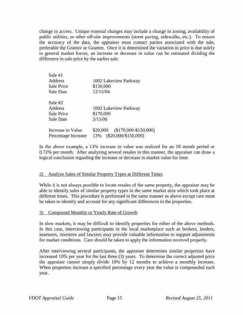
change in access. Unique external changes may include a change in zoning, availability of public utilities, or other off-site improvements (street paving, sidewalks, etc.). To ensure the accuracy of the data, the appraiser must contact parties associated with the sale, preferable the Grantor or Grantee. Once it is determined the variation in price is due solely to general market forces, an increase or decrease in value can be estimated dividing the difference in sale price by the earlier sale.
Sale #1 Address 1002 Lakeview Parkway Sale Price $150,000 Sale Date 12/15/04 Sale #2 Address 1002 Lakeview Parkway Sale Price $170,000 Sale Date 5/15/06 Increase in Value $20,000 ($170,000-$150,000) Percentage Increase 13% ($20,000/$150,000)
In the above example, a 13% increase in value was realized for an 18 month period or 0.72% per month. After analyzing several resales in this manner, the appraiser can draw a logical conclusion regarding the increase or decrease in market value for time. 2) Analyze Sales of Similar Property Types at Different Times While it is not always possible to locate resales of the same property, the appraiser may be able to identify sales of similar property types in the same market area which took place at different times. This procedure is performed in the same manner as above except care must be taken to identify and account for any significant differences in the properties. 3) Compound Monthly or Yearly Rate of Growth In slow markets, it may be difficult to identify properties for either of the above methods. In this case, interviewing participants in the local marketplace such as brokers, lenders, assessors, investors and lawyers may provide valuable information to support adjustments for market conditions. Care should be taken to apply the information received properly. After interviewing several participants, the appraiser determines similar properties have increased 10% per year for the last three (3) years. To determine the correct adjusted price the appraiser cannot simply divide 10% by 12 months to achieve a monthly increase. When properties increase a specified percentage every year the value is compounded each year.
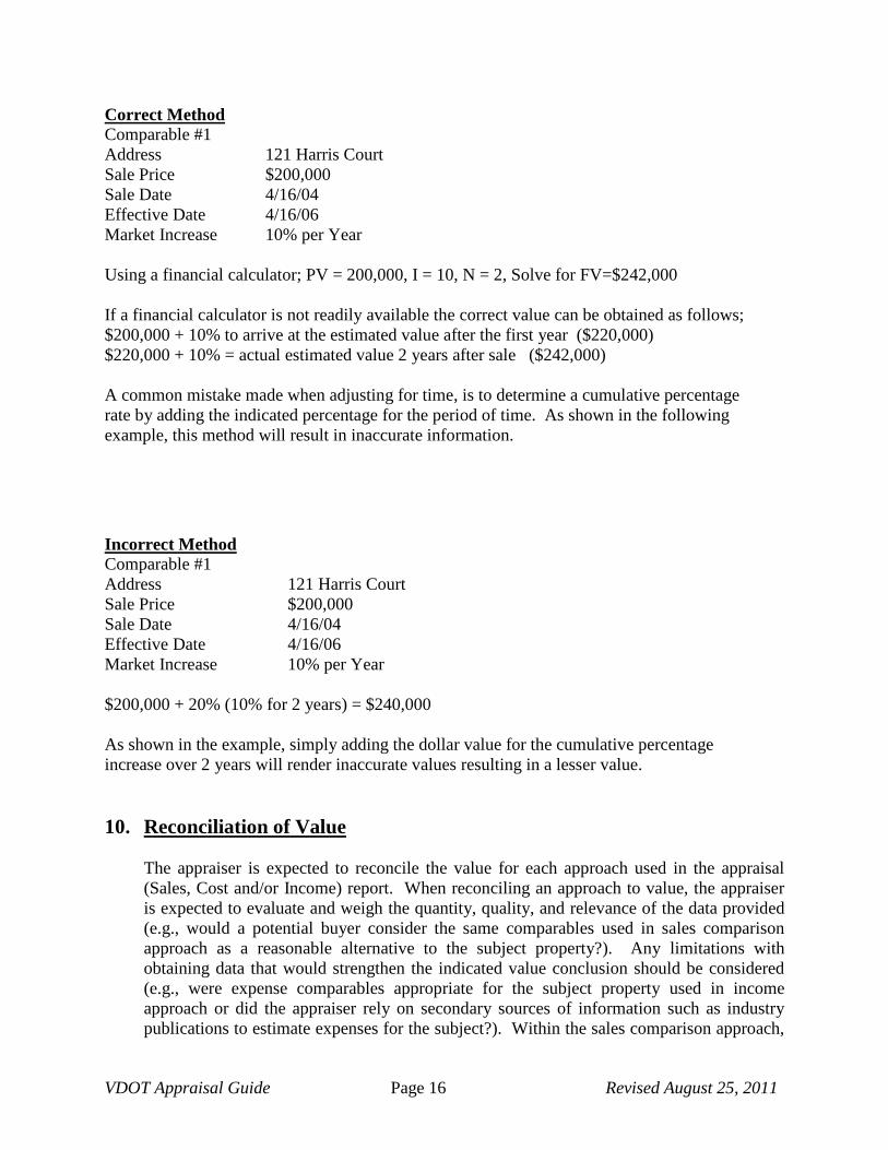
VDOT Appraisal Guide Page 16 Revised August 25, 2011
Correct Method Comparable #1 Address 121 Harris Court Sale Price $200,000 Sale Date 4/16/04 Effective Date 4/16/06 Market Increase 10% per Year Using a financial calculator; PV = 200,000, I = 10, N = 2, Solve for FV=$242,000 If a financial calculator is not readily available the correct value can be obtained as follows; $200,000 + 10% to arrive at the estimated value after the first year ($220,000) $220,000 + 10% = actual estimated value 2 years after sale ($242,000) A common mistake made when adjusting for time, is to determine a cumulative percentage rate by adding the indicated percentage for the period of time. As shown in the following example, this method will result in inaccurate information.
Incorrect Method Comparable #1 Address 121 Harris Court Sale Price $200,000 Sale Date 4/16/04 Effective Date 4/16/06 Market Increase 10% per Year $200,000 + 20% (10% for 2 years) = $240,000 As shown in the example, simply adding the dollar value for the cumulative percentage increase over 2 years will render inaccurate values resulting in a lesser value. 10. Reconciliation of Value
The appraiser is expected to reconcile the value for each approach used in the appraisal (Sales, Cost and/or Income) report. When reconciling an approach to value, the appraiser is expected to evaluate and weigh the quantity, quality, and relevance of the data provided (e.g., would a potential buyer consider the same comparables used in sales comparison approach as a reasonable alternative to the subject property?). Any limitations with obtaining data that would strengthen the indicated value conclusion should be considered (e.g., were expense comparables appropriate for the subject property used in income approach or did the appraiser rely on secondary sources of information such as industry publications to estimate expenses for the subject?). Within the sales comparison approach,

VDOT Appraisal Guide Page 17 Revised August 25, 2011
the appraiser must provide an analysis of the sale and state to what extent the sale was relied upon when determining the final indication of value within the sales comparison approach. If more than one approach to value is used in the appraisal, a final reconciliation of value is required. The final reconciliation provides the appraiser with an opportunity to review the appraisal for consistency (e.g., is the effective age of the property in the cost approach consistent with the physical condition reported?). Irrespective that the data in one approach can be more accurate and meaningful than data in another approach, market participants may consider the relevance of one approach greater than another approach (e.g., market participants may rely upon the income approach for an existing income producing property even if the data contained in the cost approach is deemed more reliable than data presented in the income approach). Evidence that supports the quality and relevance of the indicated value in each approach used is considered (e.g., were capitalization rates derived from market sales using actual expense data or were the expenses estimated by the appraiser?). The final value reconciliation of the subject property should, given the intended use of the report, reflect the use of appropriate appraisal methodology. Also, and if applicable, the reconciliation should reflect the appraiser’s confidence in the accuracy of the data and adjustments made to each comparable property as well as the reliability of other data that may have been cited in the report (e.g., cost estimates, depreciation estimates, income and expense estimates and capitalization rates). Also, the reconciliation should be consistent with the analysis and logic presented throughout the report. Once a final value for the subject property is derived, VDOT requires that the value be allocated to show the value of improvements and the land value.
11. EASEMENTS
Easements are defined as: “A right acquired by public authority to use or control property for a designated highway purpose” by the American Association of State and Highway Transportation Officials (AASHTO). and “An interest in land consisting of the right to do an act, otherwise unprivileged, on the land of another. Where the easement is restricted to the use of land, it is appurtenant to the designated land and will pass with a transfer of the land. To create this type of easement, such as a right-of-way, the same formalities as those necessary in a conveyance are usually required.” (AASHTO) There are several types of easements acquired in eminent domain proceedings, including temporary construction easements and permanent easements (examples include utilities, drainage, slopes, and sight). In addition, VDOT acquires the remaining property rights within prescriptive easements.

VDOT Appraisal Guide Page 18 Revised August 25, 2011
1. Permanent Drainage Easement An easement acquired for the placement and construction of drainage structures and access to the structures for an indefinite period of time to maintain the free flow of water. In some instances, a Storm Sewer may be constructed within the permanent drainage easement. A Storm Sewer is an enclosed underground conduit for the drainage of surface water that carries off surface drainage collected by a series of surface inlets.
2. Slope Easement
A slope easement can be either permanent or temporary and will increase (fill) or lower (cut) the existing grade of the property. This easement is necessary to provide a transition between the elevation of the new roadway and the existing property elevation when this area is not acquired in fee. The slope is defined as the inclined graded area beyond the shoulder and extending from the shoulder to the natural and undisturbed surface of the ground and this is needed whenever a grade change occurs for the roadway improvement.
3. Sight Easement
Sight easements may be acquired to maintain a safe visible distance at curves or at intersections. They are acquired for the purpose of providing drivers an unobstructed view at any given point on roadways.
4. Temporary Construction Easement
A temporary construction easement is a temporary interest in land, generally used by the contractor, for the construction of a proposed improvement. This area is located outside of the proposed roadway and it is typically needed for grading purposes. After construction of the public improvement is completed, the temporary easement is extinguished, and the unencumbered fee interest in the land reverts back to the owner. The appraiser should consider the effects of proposed road building activity contemplated by the use of the temporary construction easement and determine if any lasting impact will result to the remainder of the property after the completion of the proposed project. If improvements are located within the area of the proposed construction easement, the appraiser must determine if the improvements will be impacted by the temporary construction easement and, if so, estimate the appropriate compensation.
5. Right of Way Located within a Prescriptive Easement (a/k/a Prescriptive Right
of Way) A prescriptive easement is created by the use of another's land over a period of time (see the Byrd Act located in Section 33.1-184 of the Code of Virginia). The Byrd Act references “Evidence as to Existence of a Public Road.” Many of our older roads were established in the past without acquiring the underlying property rights, or the acquisition of those rights has not been readily documented. The Byrd act clarified

VDOT Appraisal Guide Page 19 Revised August 25, 2011
the state’s interest. The state now has a prescriptive easement for public roadway purposes, while the underlying fee ownership remains with the property owner on both sides of the roadway. While the property owner may have purchased and paid real estate taxes on acreage including the easement area, use of it is controlled by the Commonwealth. The easement is typically measured fifteen feet in width on either side of the center of the existing road making a total width of thirty feet. Unlike easements by express or implied grant, an easement by prescription may be extinguished by non-use and the ownership reverts to the subservient estate (property owner).
6. Overlapping Easements Issue Easements are generally valued on the basis of a percentage of the fee value in accordance with the impact the easement has on the underlying property rights. Various types of easements impose different impacts on the remainder, thus the percentage used will not necessarily be the same for each easement. When multiple and overlapping easements are involved, the process of trying to balance out the easements in the after value can become quite intricate and at times frustrating when the remaining property unit value changes from that estimated in the before value. However, it should be noted that when the unit value does not change upon valuing the remainder(s), the appraiser merely needs to deduct the value of the total easements acquired from the remainder property value. As a result, the appraiser is not required to break out the value of individual easements and/or overlapping easements in the “after value” under this scenario.
Treatment – Gross Easement Method There are a couple of techniques generally used by appraisers to balance out easement valuations in the after situation.
The simplest approach is to value the gross easement area, or the maximum area encumbered by easements. In the after situation, it is simply a matter of applying the fee value to the unencumbered area. For the area that is encumbered by one or more easements, the appraiser estimates its value as a percentage of the total Fee Simple value. For instance, an appraiser estimates that the encumbered area has a Fee Simple value (as if unencumbered) of $1,000. Then, the appraiser estimates the total percentage of fee simple value that the gross easement area represents. In this example, the appraiser estimates that the encumbered area is worth 90% of the Fee Simple Value of $1,000 because the appraiser determined that the easements have a high impact on the property owner’s ability to enjoy their property, thus a higher percentage of value was estimated. The estimated value of the Gross Easement Area is $900 ($1,000 x 0.90). Upon estimating the value of the Gross Easement Area, the appraiser can then segregate this total value and estimate the value of various easements located within the Overlapping Easement area. For example, the area encumbered by the water line is equal to 25% of the total encumbered value, the area encumbered by the sewer line equals 25% and the power line easement represents

VDOT Appraisal Guide Page 20 Revised August 25, 2011
50%. Under no circumstances should the value of an overlapping easement exceed the fee simple value of the land that it encumbers.
An example of this method is shown below:
Value of the Property: Land 45,000 SF x $1.00 = $45,000
Value of the Acquisition: Fee Acquisition 5,000 SF x $1.00 = $5,000 Gross Ease. Area 3,700 SF x $1.00 x 30% = $1,110
Total Value of the Acquisition = $6,110
Value of the Remainder Before Damages/Enhancements: = $38,890
When using the Gross Easement Area, the appraiser is required to allocate value to the individual easements. An allocation of the estimated value attributed to each easement is shown below. The appraiser will be prompted to provide this information in the VDOT Executive Summary of any form report completed. In the event that the appraiser is requested to complete a narrative report for VDOT, the appraiser may calculate this allocation in an Addendum and enter the results in the body of the appraisal report. The appraiser should consider the relative area the easement occupies as well as the relative impact on the use and value of the property. An illustration follows that assumes the Drainage Easement has the greatest impact at 50% and the remaining power and phone easement have an equal impact of 25% each:
Gross Ease. Area 3,700 SF x $1.00 X 30% = $1,110 Power Ease. $1,110 X 25% $277 Phone Ease. $1,110 X 25% $278 Perm. Drain. Ease. $1,110 x 50% $555
Treatment – Breakdown Method A more precise method is to complete a breakdown accounting for each type of easement that is located in the overlapping areas. The appropriate percentage of fee value is applied to each type of easement. This method requires careful computation of areas in order to determine an accurate valuation. It may be helpful to correlate the various easements and overlapping areas by developing a sketch itemizing the easements by type, area, overlapped portions, and applicable percentage rate. This will enable the appraiser to allocate the easement areas and their respective estimated values so that their values add up to the total value of the area encumbered by the Overlapping Easements.

VDOT Appraisal Guide Page 21 Revised August 25, 2011
Reasoning Although the valuations derived by each of the above methods may differ slightly, both are valid approaches to balancing out easements in the after value. While the breakdown method may be more precise, extremely complex situations may be encountered where the gross easement method would be more practical to use. The appraiser should carefully select the most appropriate method, being sure that the rationale is reasonable and that it can easily be understood by the reader of the report.
Example
The sketch below illustrates a typical VDOT right of way acquisition. The phone company easement is overlapped by the power company easement. A permanent drainage easement overlaps the phone and power easements.
Whole Area = 45,000 SF Fee Acquisition = 5,000 SF Remainder = 40,000 SF Power Co. Ease. = 3,000 SF Phone Co. Ease. = 2,000 SF Perm. Drain. Ease. = 1,000SF
Using the breakdown method, compensation is allocated to the individual easement areas. In the previous example shown, the power company easement is overlapped by the phone company easement. The power easement is valued at 20% and the area overlapped by the phone easement at an additional 10%, or a total of 30%. The drainage easement is valued at 50% of fee value and overlaps 300 SF of the utility easements. If it is determined that no additional impact is caused by overlapping easements, the larger easement can be designated as the dominant easement and the value assigned to it. The subordinate easement is then shown in the summary as “No Value” with a footnote explaining why.
200’
25’
10’
5’
Power Co.
PDE
Phone Co.
Prop. R/W
225’
50’

VDOT Appraisal Guide Page 22 Revised August 25, 2011
VALUATION SUMMARY Value of the Property: Land 45,000 SF x $1.00 = $45,000
Value Of The Acquisition: Fee Acquisition 5,000 SF X $1.00 = $5,000 Power Co. Ease. 3,000 SF X $1.00 x 20% = $600 Phone Co. Ease 2,000 SF X $1.00 x 10% = $200 Perm Drain Ease. 1,000 SF X $1.00 x 50% = $500
Total Value of the Acquisition = $6,300
Value Of The Remainder Before: = $38,700
Value of the Remainder After: Unencumbered Land 36,300 SF X $1.00 = $36,300 Power Co. Ease. (no overlap) 900 SF X $1.00 x 80% = $720 Phone Co. Ease. (overlaps power) 1,800 SF X $1.00 x 70% = $,1,260 Perm Drain Ease. (no overlap) 700 SF X $1.00 x 50% = $350 Perm Drain Ease. (overlaps power) 100 SF X $1.00 x 30% = $30 Perm Drain Ease. (overlaps power and phone) 200 SF X $1.00 x 20% = $40
Total Value of the Remainder After = $38,700
This example assumes that the power company easement is valued at 20% of fee. The appraiser believes that the area encumbered by both the phone and power company easements is worth 30% and is therefore including the phone company easement at 10% of fee simple value which represents the increment. The permanent drainage easement is valued at 50%.
In the after value, the area that is encumbered only by the power easement totals 900 square feet. The value of the remaining property rights for this area is equal to 100% less the percentage of value placed on the easement’s acquisition value or 80% (100%-20%). The combined phone company and power company easement area that is located outside the permanent drainage easement area equals 1,800 square feet (10 feet by 180 feet). The value of the remaining property rights for this area is equal to 100% less the percentage of value placed on the combined phone and power easement area or 70% (100%-20%-10%).
The area that is encumbered only by the permanent drainage easement equals 700 square feet (20 feet by 35 feet). The value of the remaining property rights for this area is equal to 100% less the percentage of value placed on the easement’s acquisition value or 50% (100%-50%). The area that is encumbered by both the permanent drainage easement and the power company easement equals 100 square feet (20 feet by 5 feet). The combined easements total 70% of fee simple value (50% plus 20%). The value of the remaining property rights for this area is equal to 100% less the percentage of value placed on the easement’s acquisition value or 30% (100%-70%). The area that is encumbered by the permanent drainage easement and the combined power and phone easement equals 200 square feet (20 feet by 10 feet).
VDOT Appraisal Guide Page 23 Revised August 25, 2011
The value of the remaining property rights for this area is equal to 100% less the percentage of value placed on the easement’s acquisition value or 80% (100%-50%- 30%).
The after valuation indicates the net areas of the individual easements. The value of each one is computed at the rate applicable to that portion of the easement. In addition, the value of the total overlapping easement should never exceed 100% of the fee simple value.
12. Enhancements: General vs. Special / Peculiar Benefits
Issue Per the Code of Virginia (33.1-130), VDOT allows any type of enhancement (general or special/peculiar benefits) to offset damages. Treatment General benefits are those that accrue to the greater area as the result of a project. An example would be better transportation linkage between one section of a city and another that results in greater property values. Special or peculiar benefits are those that accrue to a specific property as a result of the project. An example might include a new interstate causing a formerly secondary location on a state highway to become an interstate interchange with commercial potential. On the whole, special benefits are easier to document and explain. For instance, when attempting to discount project influence in the “before” value, it may be easier to measure the market reaction to the property’s specific location relative to the project than to segregate the broader market appreciation brought about from the general anticipation of the project. In many cases the difference between the types of benefits is not clear. The appraiser’s responsibility is not to distinguish between the two but rather to provide adequate information to support a conclusion. Reasoning The Commonwealth of Virginia permits damages to be offset by any type of enhancement; however, enhancements cannot offset the acquisition. It is the responsibility of the appraiser to be aware of and accurately identify and quantify all enhancements.
13. Types of Damages
In condemnation, damages are defined as the loss in value to the remainder in a partial taking of a property. Generally, the difference between the value of the whole property before the taking and the value of the remainder after the taking is the measure of the value of the part taken and damages to the remainder” (The Dictionary of Real Estate Appraisal,

VDOT Appraisal Guide Page 24 Revised August 25, 2011
3rd edition: Appraisal Institute). Damages cannot result when VDOT acquires the entire ownership because compensation is made for the acquisition of the total property, and there is no remainder left to damage. Damages should be supported by an appraiser to the same extent as the value of a property acquisition.
1. Consequential Damages
Consequential damage is defined as a negative influence to neighboring property arising as a result of acquisition and/or construction. Some properties adjacent to the proposed right of way may suffer damages as a result of a grade change or other effects of construction. The appraisal of consequential damages is typically a unique appraisal assignment.
2. Severance Damages
Is the diminuation of the market value of the remainder area, in the case of a partial taking, that arises by reason of the taking and/or the construction of the highway project in the manner proposed.
3. Proximity Damages
Defined as an element of severance damages that is caused by the remainder's proximity to the highway improvement being constructed. This type of damage is typically measured using comparable sales The appraiser investigates and analyzes several recently sold comparable properties located near roadways, with similar setbacks, as that proposed for the subject property once the proposed roadway improvements are completed. The appraiser compares each of these sale properties with other properties that have been sold recently and are comparable except for their proximity to the highway. Upon completing this analysis, the appraiser can develop an estimate of damage, or lack thereof, attributable to proximity of a proposed highway project to the property that is being appraised.
It is often difficult to find recently sold properties that are similar enough to the subject property in the after situation to use for direct comparison. In this case, a proximity study may be one source of information for consideration. Proximity studies examine the impact of reduced distance between properties and roadways to determine any impact on market value. However, the appraiser should be careful when applying a proximity study to ensure that similar market conditions exist in the subject property market area when compared to the market area where the proximity study was completed. Likewise, the real estate product used in the study (e.g. “starter housing”) should be similar when compared to the property that the appraiser is valuing.
For example, if a proximity study is completed in a highly active market on “starter homes”, the study may reflect that market participants show no adverse reaction with respect to price paid because of a change in proximity to the roadway. However, it may be inappropriate to apply the result of this study to a “starter home” that is located within a slow market. In a slow market, a price difference may exist as

VDOT Appraisal Guide Page 25 Revised August 25, 2011
buyers may expect a discount on the price given the proxmity of the “starter home” to the roadway. Likewise, it may be inappropriate to use the proximity study completed using “starter housing” for an appraisal of a custom developed home, even if it is located in the same market with similar market conditions. Buyers with varying demographic characterisitics, or buyers in a difference market segment, may react differently to proximity concerns. Please refer to Chapter 4 of the Right of Way and Utilities Manual, Section 4.3.22, “Damages” and Section 4.3.23 “Non-Compensable Damages” for a listing of damages that are considered compensable or non-compensable.
14. Cost to Cure Damages
If the proposed acquisition will damage the remaining property, the cost to cure method must be used when it is cost effective (i.e., if the cost to cure is less than the indicated amount of damage). However, under no circumstances can a cost to cure be used if the cost to cure exceeds the amount of damage that is indicated. Example The proposed acquisition includes a section of drainfield servicing a recently constructed home. This home has no access to public sewer. Its value prior to the proposed acquisition is estimated at $200,000. A cost estimate of $10,000 was obtained by the appraiser from a local contractor to relocate the drainfield out of the acquistion area. If the cure is not undertaken, the home’s value after the acquisition is estimated at $50,000. Since the dimunation in value is $150,000 and the “cost to cure” (cost to re-establish a drainfield) is only $10,000, the appraiser must conclude that the damage is curable and estimate the cost to cure the damage at $10,000.
Cost to Cure Damages – Specific Topics Highlighted 1. Fencing
When VDOT acquires fencing that is serving a functional purpose (e.g., farm fence, security fence, etc.) and it is necessary for the continued use of the property, the appraiser will place a value to re-enclose the remainder with a similar-type fence (cost to cure). The estimated price to re-enclose the fencing is based on the cost to install and replace similar fencing in the area. For example, if the existing fence is three-strand barbed wire, the appraiser will document the replacement cost data by obtaining cost estimates from local fencing contractors to complete the work. The cost to re-enclose the property will be shown on the “Executive Summary” sheet of the appraisal report as a cost-to-cure damage, “incidental item”. In addition, the appraiser should state the cost source and provide the contact name and phone number so that the property owner may contact them to complete the job is they choose to do so. If the linear feet of fencing required to re-enclose the property is less than the amount that is being acquired by VDOT, the depreciated value of the remaining fencing shall

VDOT Appraisal Guide Page 26 Revised August 25, 2011
be paid to the owner as a site improvement. For example, 500 linear feet of fencing is located within the acquisition, after the acquisition, it will be necessary to install 400 linear feet to re-enclose the property, therefore, 400 linear feet of fencing shall be paid as a cost to cure item. The remaining 100 linear feet of fencing within the acquisition will be paid for based on the depreciated value of the fencing and itemized as an “other” improvement on the summary sheet of the report. The narrative explanation will be contained within the body of the appraisal. All other fencing will be handled as a site improvement and valued as to its contributing value to the whole property. If the fence does contribute value, normally, it is computed on the cost new, less depreciation for condition and utility. A complete description of the fence will be included in the property description and its value included in the valuations of the whole property. When a temporary and/or permanent easement lies behind the proposed right of way, it may be necessary to install temporary enclosure and/or security fence prior to construction. It is the appraisers’ responsibility to determine if the temporary fencing and/or permanent fencing will be installed as part of the construction contract or if it shall be included in the compensation to the owner. If the appraiser is unable to make a determination, they should contact their local Right Way and Utilities Manager and request clarification on the fencing status. When the construction contract states that the fencing will be replaced, the appraiser will not pay to re-enclose the fencing for the property. If the permanent fencing is going to be installed, but temporary fencing is not, the owner shall be paid the cost to cure value necessary to enclose the property prior to construction. If neither temporary nor permanent fencing is to be included in the construction contract, the property owner shall be paid the cost necessary to install temporary fencing as well as the cost to install permanent fencing and the cost to remove the temporary fencing. It is not required that the temporary fencing be exactly the same as the permanent fencing.
2. Property Pins It will be assumed that all of the engineering information regarding the location of any property pins has been properly secured, verified, and located by the survey party and that this is correctly indicated on the plans. The appraiser should study the plans to determine if any property pins fall within the proposed right of way. Where there are property pins that fall within the acquisition, it will be the appraiser’s responsibility to furnish an estimate of the cost of resetting or replacing the pins and explain same in the appraisal. The estimate must be based upon the number of pins required to re-enclose the landowner’s survey, not the number of existing pins within the acquisition. When the acquisition requires the replacement of multiple pins, the appraiser is expected to compare the cost of the per pin estimate to a total property survey cost. The estimated cost of resetting or replacing the pins will be shown in the appraisal and will be

VDOT Appraisal Guide Page 27 Revised August 25, 2011
considered as part of the acquisition and identified as a pay item on the summary sheet under damage, cost-to-cure, incidental item.
15. Appraising Remainder Parcels
Prior to explaining how to appraise a “remainder” parcel, its definition must be explained along with other commonly used terms that describe property that will remain after a proposed acquisition is made. “Remainder parcels” can be further classified as either residue or surplus parcels. Their definitions follow:
1. Remainder Parcel - The portion of a property that remains after the proposed
acquisition has taken place. It would include all land with existing easements and improvements (as they exist prior to proposed acquisition) and any easements acquired by VDOT as a result of the acquisition.
2. Residue Parcels – If the acquisition severs the remainder so that multiple parcels will
make up the remainder, each parcel is referred to as a residue parcel.
3. Surplus Parcel – This is a parcel of land that lies within “operating right of way” that
is no longer needed. Please refer to VDOT’s Right of Way and Utilities Manual, Chapter 7, Basic Terms and Concepts, for a more complete explanation.
When illustrating the property value both before and after the acquisition in the appraisal report, it may be necessary for the appraiser to find comparable properties that are similar to the whole property before the acquisition and then use a separate set of comparable properties that are more similar to the residue after the acquisition. It is possible that as a result of the acquisition, multiple residue parcels may exist. If so, each residue may need to be appraised independently. In this case, the appraiser should attempt to find sales that are reflective of the individual characteristics of each residue parcel. Residue and Surplus parcels are divided into two basic categories for VDOT’s specific purpose. The categories are defined as a “Class 1” or a “Class 2” property. A Class 1 parcel can be independently developed as a “stand-alone” tract of land. A Class 2 property can not be independently developed and it may require assemblage to an adjoining parcel to enhance its utility and the adjoining parcel’s utility. The appraiser must make the determination as to whether the parcel is considered a Class 1 or a Class 2 parcel. When assemblage is the highest and best use for an uneconomic remnant, the parcel is typically appraised as follows: Step 1: The adjacent parcel is appraised as if it were combined with the uneconomic remnant. Step 2: The adjacent parcel is then appraised without the uneconomic remnant.
VDOT Appraisal Guide Page 28 Revised August 25, 2011
Step 3: The difference in value is the basis for the appraiser’s value conclusion. If the uneconomic remnant has more than one adjacent parcel, then the appraiser must determine which parcel, combined with the uneconomic remnant, will result in the greatest value. In addition, it should be noted that at times the assemblage of an uneconomic remnant may add value to the existing improvements or it may change the highest and best use of the adjacent parcel. If there are applicable sales of uneconomic remnants, the appraiser can estimate the value by simply using the direct sales comparison approach.
16. Total Acquisition with an Uneconomic Remnant
Total Acquisition This terminology is to be used when the entire property is needed for road construction purposes. This will be denoted on the plans with “Proposed Right of Way” labeled around the entire boundary of the property. Total Acquisition with an Uneconomic Remnant In some instances, a partial acquisition may result in a loss of value to the degree that the remainder becomes an “uneconomic remnant” (a remaining parcel with a nominal value). In this case, the Right of Way and Utilities Manager may determine that the entire property should be acquired, thereby effectively making it a total acquisition. However, unlike a total acquisition, the value of the uneconomic remnant must be stated in the appraisal separately from the acquisition value for accounting and negotiation purposes. When reviewing the project plan sheet, a “Proposed Right of Way Line” identifying the fee simple acquisition area required for the project and “Proposed Acquisition Line” labeling the remainder will illustrate this type of acquisition.
17. Excess Land vs. Surplus Land
It should be noted that the term “Surplus Land” should not be confused with the term “Surplus Parcel”. Excess and Surplus land is a portion of an existing parcel that is not necessary to support the site’s highest and best use. Excess land can be developed either to expand the existing improvement and/or for independent development. On the other hand, Surplus Land does not allow for any further development. An example of Surplus Land is additional land adjacent to an office building that can not support the further development of the site but that may be used for other uses (e.g., employee volleyball court). Treatment When valuing excess land, either vacant or improved, care should be taken to develop the highest and best use of the excess land. For example, a typical residential dwelling site in the subject’s market area is 3 acres. The subject site is 6 acres. The additional 3 acres will physically and legally support the independent development of a second residence.

VDOT Appraisal Guide Page 29 Revised August 25, 2011
Therefore, 3 acres of the site is considered excess land. The appraiser must show the value of two residential lots in the cost approach under site value. The additional site must be considered in the Sales Comparison Approach when compared to other properties that may not have excess land. An example of Surplus Land exists when, in the same market, a site is 4 acres but only 3 acres are required to develop the site to its highest and best use and the additional one acre can not be developed as an independent site. The additional one acre is considered Surplus Land. In this scenario, the Surplus Land would not have the same value per acre as the site that is needed to support the development of the improvements. If market evidence suggests that typical buyers and sellers would not expect to pay the same price per unit (e.g., acre) for the surplus land, the appraiser may segregate the land value into a value per acre for the site area necessary to support the development of the improvements and determine a value for the portion of the site that is considered surplus land. In addition, depending upon the nature of the proposed acquisition, the appraiser may elect to use a blended rate per unit (e.g., acre) and simply apply this to the area acquired. If the market demonstrates that a buyer is willing to pay the same price per acre for a 3 versus a 4 acre lot with surplus land, this should be reflected when determining the value of the acquisition.
18. Appraising On-Premise or Non-Permitted Signs
On-premise signs that do not require a permit are divided into two categories:
1. Significant signs
Significant signs have a value in excess of $5,000 and/or they require at least one of the following:
a. electrical service b. services of a sign company for repair c. services of a sign company for relocation d. services of a masonry contractor
They are apprised by determining their depreciated value. The cost of relocating the sign elsewhere on the property, the cost of removing the sign from the property, and the retention (salvage) value shall also be included in the specialty appraisal. A specialty appraisal is required on a significant sign.
2. Non-Significant signs
These signs typically have a value of less than $5,000 and they can be easily relocated on the property or removed. In addition, they have a nominal retention/salvage value. The cost of these signs, less depreciation, can be developed by obtaining a cost estimate or by using a cost index, such as Marshall & Swift.

VDOT Appraisal Guide Page 30 Revised August 25, 2011
Also, the appraiser must include:
1. The relocation cost for the sign. 2. The salvage value.
The relocation cost must be provided because VDOT must offer to purchase any improvement in the acquisition area. However, the owner may request that VDOT allow them to relocate the sign and the relocation costs provide a basis for negotiation.
The cost to relocate an on-premise and/or non-permitted sign cannot exceed the contributory value of the sign.
19. Outdoor Advertising Signs
Problem Outdoor Advertising appraisals present several unique problems relating to issues of real estate vs. business value and the methodology required in the application of these concepts. Most notably, the income attributed to the real estate must be segregated from the income that is attributed to the overall revenue stream for the business. Treatment Prior to valuing an outdoor advertising sign, the appraiser must be approved by VDOT’s Chief Appraiser to conduct the valuation. VDOT has a comprehensive course to educate appraisal specialists and managers on this topic. Outdoor Advertising appraisal problems must be referred to the Chief Appraiser. An Outdoor Advertising Task Force, consisting of appraisal and legal specialists, will review germane topics on a case-by-case basis upon the request of the Chief Appraiser. If an appraiser is faced with a situation whereby an outdoor advertising sign exists on the subject property, and they have not been pre-approved by VDOT’s Chief Appraiser to value outdoor advertising signs, the appraiser should contact their District Right of Way and Utilities Manager for further instructions.
Reasoning The Commonwealth is committed to specifically addressing this issue competently and is seeking to manage each case and educate appraisers to this specialty area of valuation. Note: See the section on Tenant Owned Improvements within this Appraisal Guide where three Executive Summaries are required in the appraisal report.
VDOT Appraisal Guide Page 31 Revised August 25, 2011
20. Primary vs. Secondary Data Sources and Incorporating Information from Other Reports
Primary data is information that is gathered and evaluated first hand (confirming sales comparables). When using primary data, the source and date confirmed should be stated. Secondary data is information derived from sources where the data is not directly compiled. Sources for secondary data may include real estate publications, research compiled by local brokers, and other data sources. Secondary data is often used to supplement data in the market analysis section of a report. Secondary data should be current, relevant, reliable, accurate, and conceptually correct. Secondary data should not reflect manipulation, carelessness, or conceptual errors by the person organization or supplying the data. In addition to secondary data, it may be necessary to rely upon secondary or "specialty" appraisal reports. These reports may address a specific issue within the overall valuation (e.g., the value of a sign). The same criteria used to determine the appropriateness of secondary data is used when determining if the data contained in a "specialty report" are appropriate. In addition, the appraiser must ensure that the report complies with USPAP in effect as of the effective date of the report. If the appraiser concludes that the data contained in the report is appropriate, that the report complies with USPAP, and that the conclusions seem credible, the appraiser may extend the conclusions made into their appraisal by use of an extraordinary assumption.
21. Revised and Updated Appraisals When information that will have an affect on the appraised value is received after the original submission of an appraisal, a revised appraisal may be obtained. The information received may be new market data, plan revisions, revised estimates, change in use, zoning, additional improvements, etc., that will have an effect on the appraised value of the acquisition and if applicable, the remainder. A revised appraisal follows the same review and approval process as an original submission. It is the responsibility of the District Manager, or Assistant District Manager, to determine the need for an updated appraisal. Requesting an update of an appraisal because of a time lapse should be based upon local market conditions and the property type. A rapidly changing market will require an updated appraisal sooner than when the market is stable. An appraisal update may be appropriate before filing a certificate for condemnation. This may be cause for reopening previously unsuccessful negotiations.
22. Data Ownership
The Commonwealth of Virginia owns data provided to VDOT in an appraisal report or as a result of the appraisal process. At times, market participants may agree to provide data to
VDOT Appraisal Guide Page 32 Revised August 25, 2011
an appraiser, and they may request that the information provided by them be kept confidential other than for use by VDOT. The confidentiality of data and the data sources provided in an appraisal report cannot be guaranteed. VDOT distributes appraisals to property owners and other sources as required by law. While not preferred, anonymous sources of data will be accepted when no other market data is available (e.g., comparable property operating statements) and the market participant providing the data requests anonymity. However, this data should also be supported by secondary data sources (e.g., Dollars and Cents or Shopping Centers showing expense trends within the market, etc.).
23. Interim Use
When appraising real property one of the most important factors the appraiser must determine is the highest and best use of the property. When the current highest and best use of a property is estimated to be for a short time, before transitioning to a different highest and best use, the current use is considered to be its interim use or sometimes referred to as transitional use. Interim Use is defined in the Real Estate Appraisal Terminology (revised edition, p.137) as “that existing and relatively temporary use where the transition to highest and best use is deferred.” In essence, a property may have two highest and best uses, one for a relatively short period of time, or its current highest and best use, while another will become the highest and best use at some point in the future. This is usually the result of changing land use patterns often in combination with obsolescence in the improvements. On occasion the appraiser will encounter situations where the land value has exceeded the value that can be generated by the improvements and yet the land is not ready for development. This could be due to impending but not yet present improvements in infrastructure like roads or utilities. It may also be due to market demand factors that have not yet matured. Whatever the cause, the appraiser is left with the dilemma of valuing the interim use improvements. Since the land is not yet ready for development, there is no income during the remaining holding period other than that contributed by the interim improvements. The value of these improvements then is measured by discounting the projected net income stream for the time remaining and deducting the present value of the cost of demolition at the termination of use. The appraiser should be careful to only include expenses attributable to the improvements alone, i.e., those that would not be incurred if the improvements were removed. Alternately, this value may be supported by finding sales of other properties with interim uses and deducting land value to determine the contribution of the interim use improvements. The Cost Approach is not really relevant since the improvements do not serve the highest and best use. However, if included, the appraiser should use the limited remaining life as a basis for depreciation as the actual condition of improvements is a relatively moot point. Several factors must be taken into consideration when utilizing this methodology. First, it may be more difficult to attract or maintain tenants when they are aware that the
VDOT Appraisal Guide Page 33 Revised August 25, 2011
improvements have a limited remaining life. Secondly, some investors may prefer the liquidity of removing these improvements and may also be reluctant to endure the trouble and potential liability. These factors should be taken into consideration when choosing an appropriately risk-rated yield.
24. Misplaced Improvement
IRWA defines misplaced improvements as: “Improvements (on land) of a use-type that do not conform to the most profitable use-type for the site.” And “An appraisal term indicating an improvement on land which is not the highest and best use.”
When valuing properties for eminent domain purposes, misplaced improvements may exist either prior to the proposed acquisition taking place (“the before value”) and/or after the proposed acquisition has taken place (“the after value”). Example 1 – A Misplaced Improvement Before the Acquisition: The appraiser is assigned a property located in Albemarle County, VA. The property consists of a 2,600 square foot home located on a 30,000 square foot parcel of land. The property is currently zoned B-1. While researching sales, the appraiser identified several comparable vacant land sales that sold for $200,000. The appraiser also identified several sales improved with residential dwellings located on lots of similar size that sold for $175,000. Based upon market evidence, the appraiser determines that an immediate demand exists for commercial property in the subject property’s market area. As a result, the appraiser determined that the highest and best use of the property, as if vacant, is for commercial development. The appraiser also determines that the highest and best use of the property, as improved, is to immediately demolish the improvements. In addition, upon verifying sales of properties with commercial potential, he learns that demolition costs are a consideration and that the cost to demolish the residential structure on the subject site would be approximately $15,000. In this example, the dwelling and its supporting improvements have no value. If the acquisition is a total acquisition, compensation will be based upon the property’s highest and best use, a commercial site. Consequently, no compensation for the residential improvements will be paid to the property owner. In addition, if the acquisition is a partial acquisition whereby the dwelling will remain after acquisition, no payment should be made for the supporting site improvements to the dwelling that may be acquired. Most importantly, no damages should be assessed to the remaining dwelling and its supporting

VDOT Appraisal Guide Page 34 Revised August 25, 2011
improvements since they have no value when determining the “before value” of the property.
Example 2 – A Misplaced Improvement Resulting From the Acquisition: When an acquisition reduces the functional utility or efficiency of an improvement, and its highest and best use, as improved, has changed when developing the “After Value”, the improvement is considered to be a misplaced improvement. In this example, the subject property consists of 50 acres of pasture land. Improvements on the property include a 4,500 square foot pole barn that is used to store hay for the livestock and farm fencing. The proposed acquisition will sever the property. The acquisition consists of 5.0 acres. After the acquisition, 41.5 acres will remain to the east of the relocated roadway and 3.5 acres will remain to the west. The pole barn will reside on the 3.5 acre site located to the west of the relocated roadway. After acquisition, the appraiser concludes that the highest and best use of the 3.5 acre parcel is a single-family home site. The highest and best use of the 41.5 acres located to the east of the roadway improvements remains pasture land. The appraiser also concludes that the pole barn has little, if any, functional utility remaining after the proposed acquisition and therefore its value becomes a damage item. When evaluating the situation, the appraiser must consider whether or not the damage can be “cured” and/or whether there are offsetting enhancements. In this example, the appraiser should determine the cost to relocate the pole barn on the larger 41.5 acre parcel where it could support the cattle operations. If the cost to relocate the barn on the larger parcel is less than the amount of damages, it is paid to the property owner as a “cost to cure” item and eliminates the incurable damage figure. If enhancement has occurred as a result of the higher unit value of the home site or from other project influences, the value of the enhancement will offset damages. If misplaced improvements are identified on a property after the acquisition, and cannot be cured, they will be identified in the “after valuation” as a damage item and should be listed on the summary sheet with the total damage figure. A narrative discussion should follow the before and after itemization discussing damages from the proposed acquisition.
VDOT Appraisal Guide Page 35 Revised August 25, 2011
ADDENDUM A
THE BASICS OF VDOT HIGHWAY PLAN READING
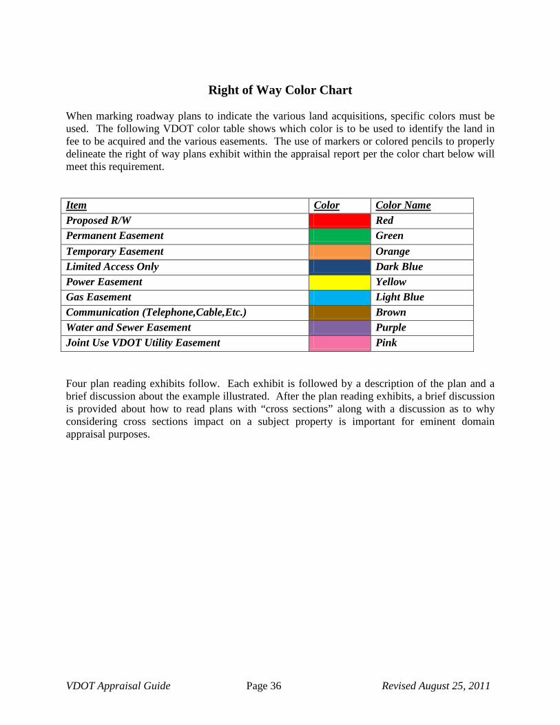
VDOT Appraisal Guide Page 36 Revised August 25, 2011
Right of Way Color Chart When marking roadway plans to indicate the various land acquisitions, specific colors must be used. The following VDOT color table shows which color is to be used to identify the land in fee to be acquired and the various easements. The use of markers or colored pencils to properly delineate the right of way plans exhibit within the appraisal report per the color chart below will meet this requirement. Item Color Color Name Proposed R/W Red Permanent Easement Green Temporary Easement Orange Limited Access Only Dark Blue Power Easement Yellow Gas Easement Light Blue Communication (Telephone,Cable,Etc.) Brown Water and Sewer Easement Purple Joint Use VDOT Utility Easement Pink
Four plan reading exhibits follow. Each exhibit is followed by a description of the plan and a brief discussion about the example illustrated. After the plan reading exhibits, a brief discussion is provided about how to read plans with “cross sections” along with a discussion as to why considering cross sections impact on a subject property is important for eminent domain appraisal purposes.

VDOT Appraisal Guide Page 37 Revised August 25, 2011
Plan Reading Example #1

VDOT Appraisal Guide Page 38 Revised August 25, 2011
Example #1 (Description) Description of Parcel The plan sheet shows
A) Current owners “Wayne E. Mickens and Phyllis G. Mickens
B) Deed Book Reference for both parcels
C) Total Size of VDOT parcels and length of property lines
D) Tax Map #
E) VDOT Parcel Number
F) Location of drain field
G) Location of well
H) Location and description of dwelling
I) Entrance and type of material used to construct entrance
J) Utility lines existing on the property and poles on adjoining properties
K) Existing roadway
This acquisition is considered to be a simple strip acquisition. As shown on the plan sheet, the property extends to the center of the existing roadway. This indicates the existence of prescriptive right of way. Prescriptive right of ways are typically 30’ wide and are measured from the center of the existing roadway, i.e., 15’ each side of the centerline. The area between the prescriptive right of way and the proposed acquisition line is called the land in fee acquisition. No easements will be needed on this parcel for the proposed roadway improvements. Payment needs to be made for any improvements within the acquisition. The property has a gravel driveway, and a portion of the driveway will be included in the acquisition. The appraiser must measure the area within the acquisition and pay the homeowner its depreciated value.
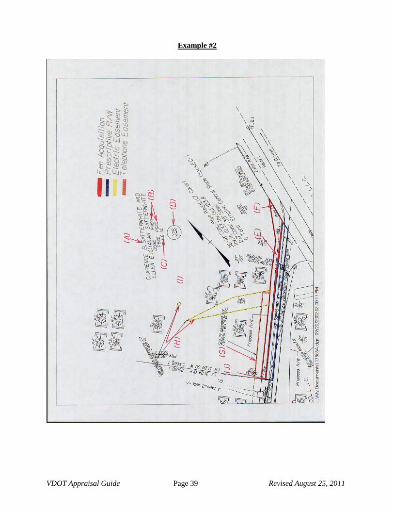
VDOT Appraisal Guide Page 39 Revised August 25, 2011
Example #2

VDOT Appraisal Guide Page 40 Revised August 25, 2011
Plan Reading Example #2 (Description) Description of Parcel The plan sheet shows
A) Current owners “Clarence B. Satterwhite and Ellen Buchanan Satterwhite”
B) Deed Book Reference for parcel “165/190”/ Plat Reference 22/25
C) Total Size of parcel
D) VDOT Parcel Number
E) North Arrow
F) Fencing (Board) wood board
This acquisition is considered to be a simple strip acquisition. As shown on the plan sheet, the property extends to the center of the Route 694 (Breedens Road). The area outlined in blue indicates the existence of prescriptive right of way. Prescriptive right of ways are typically 30’ wide and are measured from the center of the existing roadway, i.e., 15’ each side of the centerline. The area between the prescriptive right of way and the proposed acquisition line is called the land in fee acquisition, outlined in red. The plan sheet indicates the acquisition of two (2) utility easements.
G) A 15’ wide utility easement for Centel Telephone Co of Virginia outlined in brown, rectangular in shape along the southern property line. Payment will be made as a percentage of the total fee value.
H) Two (2) utility easements for Rappahannock Electric are outlined in yellow. This easement will tie into an existing easement on the property and is needed for the relocation of a utility pole on the property across Route 694. Payment for this easement will be made as a percentage of the total fee value.
NOTE: When easements overlap, the appraiser must take care not to pay more than 100% of the total fee value for the easements which overlap.
I) The plan sheet indicates fencing on the property. Barbed wire fencing on the southern property line and board fencing on the eastern property line. The appraiser must determine if the fencing is security fencing, used for containment or is decorative fencing because the use will impact the amount that VDOT will compensate the landowner. If the fencing is used for containment or security, and it is not going to be replaced by the contractor, payment must be included in the appraisal for the fencing as a “cost-to-cure” damage. If the fencing is decorative, payment will be made to the homeowner at the current depreciated value of the fencing that is being acquired.
J) The plan sheet indicates a property pin at the southernmost corner that will need to be relocated since it falls within the area of acquisition. Payment for the property pin will be made to the property owner as a cost-to-cure item.

VDOT Appraisal Guide Page 41 Revised August 25, 2011
Example #3

VDOT Appraisal Guide Page 42 Revised August 25, 2011
Example #3 (Description) The plan sheet shows:
A) Parcel Number
B) Outline of existing structure
C) Name of side-street
D) Property Line identification
E) Indicates proposed right of way line
F) Indicates slope easement
Note: When the plan sheets begin to get cluttered, designers may sometimes use symbols to indicate different easements. In this case, the designer has used the number 3 inside a diamond to identify the temporary slope easement.
G) Companies for which utility easement is acquired
H) Indicates a point on the utility easement – 34.361 meters from the construction baseline at station 10+56.042 (the dotted line points to the referenced point).
I) Indicates property pins This plan sheet shows an acquisition encompassing land in fee and easements. The land in fee acquisition (E) is indicated in red at the northwest corner of the property. One temporary slope easement (F) shall be acquired on the western property line and is identified in orange. The second easement is a utility easement for use by Dominion Virginia Power and Central Telephone Company of Virginia (G). As shown on the plan sheet, this easement will wrap around the northwest corner of the existing structure. The appraiser must analyze the easement’s effect on the property in the appraisal report and determine if a negative influence to property value exists and, if so, estimate the amount of damages attributed to the negative influence.
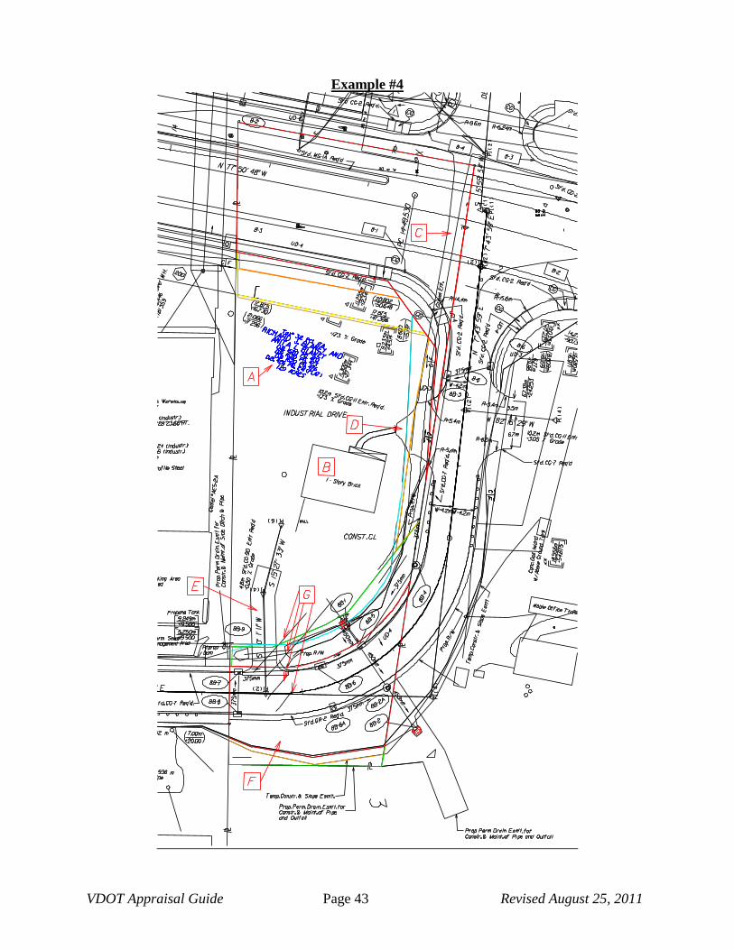
VDOT Appraisal Guide Page 43 Revised August 25, 2011
Example #4

VDOT Appraisal Guide Page 44 Revised August 25, 2011
Fee Acquisition Power Easement Phone Easement Gas Easement Permanent Easement Temporary Easement
Example #4 (Description)
The plan sheet shows
A) The current property owners, parcel number and size of site
B) Location of the dwelling and a brief description (1-Story brick)
C) An existing entrance from Rt. 649 to the south (Gravel Ent.)
D) A relocated entrance at the western property line from Industrial Drive
E) A new entrance at the northern portion of the property from relocated Industrial Drive
F) Due to the construction of Industrial Drive, a remainder parcel will exist after the proposed acquisition on the northern portion of the property. The appraiser must determine if the remainder can be independently developed after the acquisition has taken place and the roadway improvements are made (see Chapter 4, Section 4.14, of the Right of Way and Utilities Manual for the classifications of buildable and non-buildable sites). Also, the appraiser must determine if the remainder parcel has any damages and/enhancements as a result of the roadway improvements. If the appraiser estimates that damages are present, a determination must also be made if the damages are legally compensable. A discussion of damages, including those that are considered non-compensable, and enhancements is shown in Chapter 4 of the Right of Way and Utilities Manual, Sections 4.3.21 through 4.3.24.
G) The property is currently serviced by a private well and septic system. As indicated on the plat, the septic system is located within the proposed acquisition. The appraiser must determine if another septic system can be placed on the property and, if so, obtain estimates from local contractors for the construction of a new system on the site. Payment for the new system will be considered to be a cost to cure item.
If a new septic system cannot be constructed on the property the appraiser must explore all alternatives to allow for the removal of sewage from the property, and determine if the property is a buildable site after the proposed acquisition is made.
In this case, a sewer line was located within 200’ of the subject property. By obtaining cost estimates, the appraiser was able to determine that the cost to extend the sewer line was less than the cost of purchasing the entire property due to inadequate sewage disposal. Therefore, the cost to extend the sewer line is listed as a “cost to cure” item in the appraisal report.
As shown on the plan sheet, the property extends to the center of the existing roadway. The area outlined inn blue indicates the existence of a prescriptive easement. Prescriptive easements are typically 30’ wide and are measured from the center of the existing roadway i.e.; 15’ on each side of the centerline. The area between the prescriptive easement and the proposed right of way line is referred to as the land in fee acquisition, outlined in red. The land in fee acquisition on this property is located in (2) two separate locations. The first area is to the south of the improvements and the second is to the north of the improvements.

VDOT Appraisal Guide Page 45 Revised August 25, 2011
Example #4 (Description)
Easements:
Four permanent easements shall be acquired on this property. A utility easement for Sprint Centel Telephone Co. is outlined in brown, a utility easement for Dominion Power easement is outlined in yellow, and a utility easement for the City of Charlottesville, Department of Gas is outlined in light blue. The fourth permanent easement is for the construction and maintenance of a drainage structure adjacent to the proposed northern property line.
Two temporary construction easements will be acquired and are outlined in orange. The first is at the new southern right of way line and the second is adjacent to the western property line.
Note: When easements overlap, the appraiser must take care not to pay more than 100% of the total fee value for area of overlapping easements. See section in this guide on overlapping easements.

VDOT Appraisal Guide Page 46 Revised August 25, 2011
Cross Sections A cross section is a view of the project sliced open at right angles to the survey centerline at a particular station and shows elevations left and right of centerline as if facing the direction of ascending station numbers. The cross-sections show existing and proposed features left and right of centerline. The existing ground surface is shown as a dashed line and the proposed finished surface is shown as a solid line. The cross-section diagram indicates numerically the station number where the cross section is located, the elevation of the profile grade line for that station and the elevation of the existing ground on the centerline at the cross-section station. When looking at the cross-section, the left side of the cross-section is the left side of the roadway and the right side of the section is the right side of the roadway. Several sections will be drawn on a single sheet, in sequence from a lower station at the bottom of the sheet to a higher station at the top of the sheet.

VDOT Appraisal Guide Page 47 Revised August 25, 2011
Cross Section Example #1 (Cut and Fill) The following illustration shows an example of a roadway where the improvements include widening of the existing pavement with a fill on the left side of the roadway and a cut on the right.
1) Identifies the station number for the cross section. 2) Indicates the elevation of finished grade at centerline. 3) Identifies the proposed centerline of ditch at station 16+75.00 right of centerline. 4) Indicates both the distance from centerline and elevation of the centerline of ditch right of
centerline (22.47R) indicates the distance (22.47 feet) from centerline, (R) right of centerline (2273.50) indicates the elevation of finished grade at the bottom of ditch
5) Indicates the proposed top of slope elevation right of centerline (tie-in to existing) 6) Indicates both the distance from centerline and elevation of the proposed top of slope
right of centerline (30.60R) indicates the distance (30.60 feet) from centerline, (R) right of centerline (22.81.63) indicates the elevation of finished grade at the tie-in to existing grade (top of slope)
7) Indicates the existing slope 8) Indicates the proposed slope 9) Indicates the elevation for the specific horizontal line. As noted at the top of the cross
section sheet, the scale is 1” = 10’. The elevation for this vertical line is 2300.00. Because each block is 1” square, the line below references an elevation 10’ less than 2300.00 or 2290.00. Similarly, the line above would reference elevation 2310.00’.
10) Indicates the direction of the storm water flow in the ditch. In this case the runoff will flow from station 16+50 to 16+75.
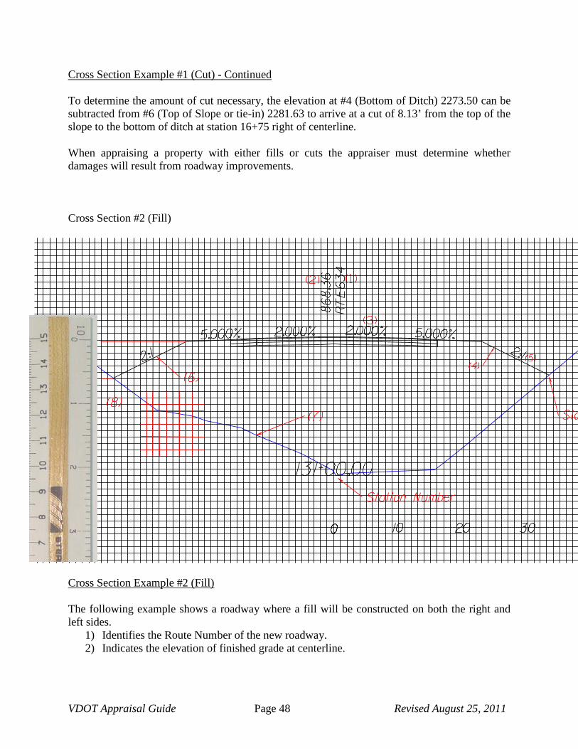
VDOT Appraisal Guide Page 48 Revised August 25, 2011
Cross Section Example #1 (Cut) - Continued
To determine the amount of cut necessary, the elevation at #4 (Bottom of Ditch) 2273.50 can be subtracted from #6 (Top of Slope or tie-in) 2281.63 to arrive at a cut of 8.13’ from the top of the slope to the bottom of ditch at station 16+75 right of centerline. When appraising a property with either fills or cuts the appraiser must determine whether damages will result from roadway improvements. Cross Section #2 (Fill)
Cross Section Example #2 (Fill) The following example shows a roadway where a fill will be constructed on both the right and left sides.
1) Identifies the Route Number of the new roadway. 2) Indicates the elevation of finished grade at centerline.
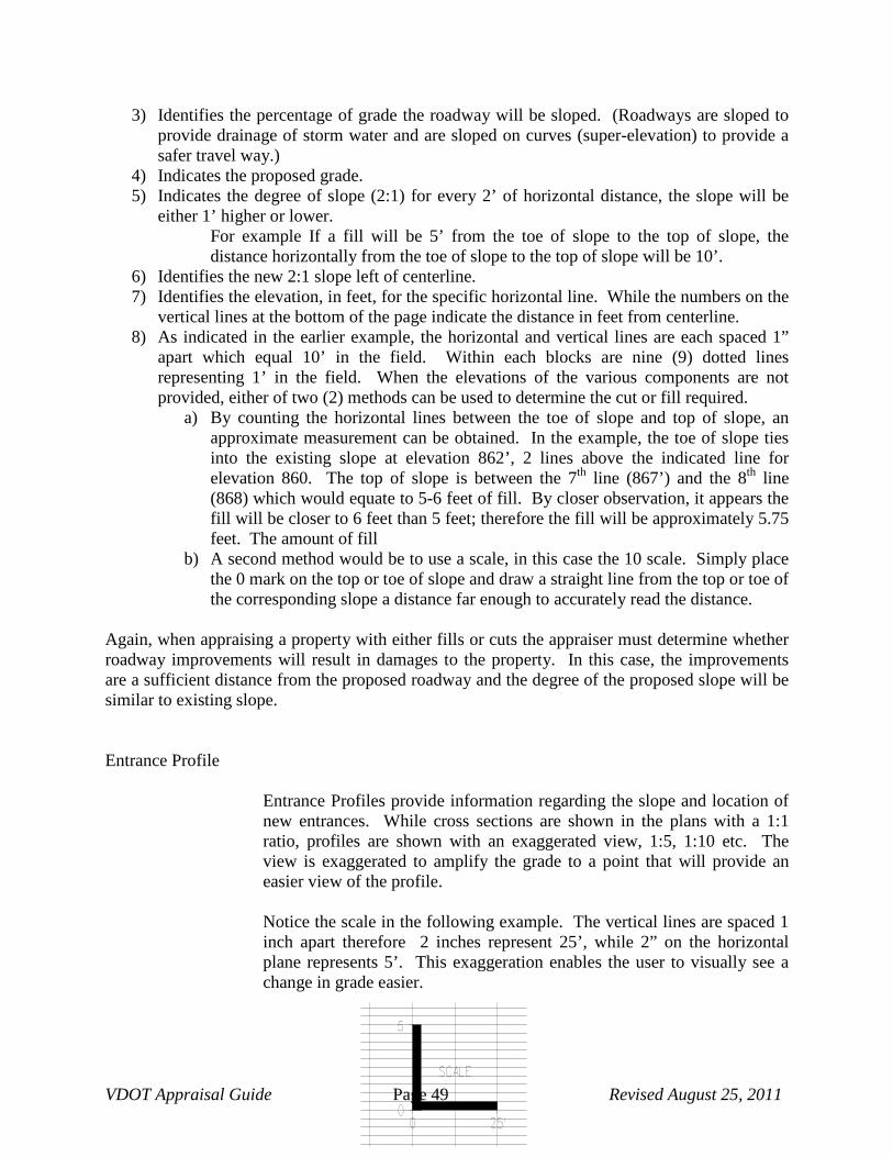
VDOT Appraisal Guide Page 49 Revised August 25, 2011
3) Identifies the percentage of grade the roadway will be sloped. (Roadways are sloped to provide drainage of storm water and are sloped on curves (super-elevation) to provide a safer travel way.)
4) Indicates the proposed grade. 5) Indicates the degree of slope (2:1) for every 2’ of horizontal distance, the slope will be
either 1’ higher or lower. For example If a fill will be 5’ from the toe of slope to the top of slope, the distance horizontally from the toe of slope to the top of slope will be 10’.
6) Identifies the new 2:1 slope left of centerline. 7) Identifies the elevation, in feet, for the specific horizontal line. While the numbers on the
vertical lines at the bottom of the page indicate the distance in feet from centerline. 8) As indicated in the earlier example, the horizontal and vertical lines are each spaced 1”
apart which equal 10’ in the field. Within each blocks are nine (9) dotted lines representing 1’ in the field. When the elevations of the various components are not provided, either of two (2) methods can be used to determine the cut or fill required.
a) By counting the horizontal lines between the toe of slope and top of slope, an approximate measurement can be obtained. In the example, the toe of slope ties into the existing slope at elevation 862’, 2 lines above the indicated line for elevation 860. The top of slope is between the 7th line (867’) and the 8th line (868) which would equate to 5-6 feet of fill. By closer observation, it appears the fill will be closer to 6 feet than 5 feet; therefore the fill will be approximately 5.75 feet. The amount of fill
b) A second method would be to use a scale, in this case the 10 scale. Simply place the 0 mark on the top or toe of slope and draw a straight line from the top or toe of the corresponding slope a distance far enough to accurately read the distance.
Again, when appraising a property with either fills or cuts the appraiser must determine whether roadway improvements will result in damages to the property. In this case, the improvements are a sufficient distance from the proposed roadway and the degree of the proposed slope will be similar to existing slope. Entrance Profile
Entrance Profiles provide information regarding the slope and location of new entrances. While cross sections are shown in the plans with a 1:1 ratio, profiles are shown with an exaggerated view, 1:5, 1:10 etc. The view is exaggerated to amplify the grade to a point that will provide an easier view of the profile.
Notice the scale in the following example. The vertical lines are spaced 1 inch apart therefore 2 inches represent 25’, while 2” on the horizontal plane represents 5’. This exaggeration enables the user to visually see a change in grade easier.

VDOT Appraisal Guide Page 50 Revised August 25, 2011
The following example identifies an entrance on Route 605 left of centerline. 1) Identifies the entrance Location – The entrance is located on Route 605 at station
618+70.01 left of the construction centerline. 2) Provides a reference for tie-in to the new roadway. “ES” refers to the edge of shoulder 3) Indicates the new entrance will have a 4% slope. In this example, by measuring the length
of the entrance using the 25 scale and dividing the indicated result (62) by 2 (The 25 scale represents, 25’ for each 1” but because the plans indicate each 2” = 25’ the result needs to be divided by 2) the new entrance tie-in will be approx. 31 feet in length. To determine the increase or decrease of grade in feet simply multiply 31’ X 4% = 1.24’.
4) Identifies the proposed grade of the new entrance. 5) Identifies the existing grade. 6) Provides a reference for the elevation. 7) Provides a reference for distance 8) If this entrance were drawn on a 5 scale (1”=5’ both horizontally and vertically) the
entrance would be similar to this reference. The drawing accurately depicts how the actual elevation will look in the field.

VDOT Appraisal Guide Page 51 Revised August 25, 2011
APPENDIX B
GLOSSARY (TERMS SPECIFIC TO EMINENT DOMAIN and APPRAISAL)
VDOT Appraisal Guide Page 52 Revised August 25, 2011
EMINENT DOMAIN DEFINITIONS FOR APPRAISALS
A Abandonment – Cessation of use of right-of-way or activity thereon with no intention to reclaim or use again for highway purposes. (sometimes called Vacation) (AASHTO) Abstract of Title – A document showing the condensed history of the title to property, containing portions of all conveyances or other pertinent instruments relating to the estate or interest in the property, and all liens, charges, encumbrances and releases. (AASHTO) Access Connection – Any roadway facility by means of which vehicles can enter or leave an arterial highway. Included are intersections at grade, private driveways and ramps, or separate lanes connecting with cross streets or frontage roads. Acquisition – The process of obtaining right-of-way. (AASHTO) After Value – The value of the remainder. Appraisal – (1) An estimate and opinion of value, (2) Usually a written statement of the market value or value as defined by the appraiser of an adequately described parcel of property as of a specific date. A conclusion that results from an analysis of facts. Appraisal Report – A written document in which is stated (1) the value conclusion, (2) the date as of which the value is estimated, (3) an adequate description of the property valued, (4) the reasoning in reaching the value conclusion, (5) the qualifying conditions, (6) market data, other factual data and processing by one or more of the three different approaches, and (7) the signature of the appraiser. Approach Nose – An end of an island, or neutral area between roadways, which faces approaching traffic that passes either on one or both sides. (AASHTO) Appurtenance – An item of property accessory to, or an adjunct of, a more important property, title to which usually passes with title to the principal property. Something which passes as an incident to land, such as right-of-way. Arterial Highway – A general term denoting a highway primarily for through traffic, usually on a continuous route. (AASHTO) At Grade Intersection – An intersection where all roadways join or cross at the same level. (AASHTO) Auxiliary Lane – The portion of the roadway adjoining the traveled way for parking, speed-change, or for other purposes supplementary to through traffic movement. (AASHTO)

VDOT Appraisal Guide Page 53 Revised August 25, 2011
Average Daily Traffic – The average 24 hour volume, being the total volume during a stated period divided by the number of days in that period. Unless otherwise stated, the period is a year. The term is commonly abbreviated as ADT. (AASHTO)
B
Backfill – Material used to replace or the act of replacing material removed during construction; also may denote material placed or the act of placing material adjacent to structures. (AASHTO) Backslope – That portion of the roadway between the side drainage ditch and the top of cut, usually measured as a ratio of horizontal distance versus each foot of increase in elevation, i.e., – 4 to 1 slope. Basic Capacity – The maximum number of passenger cars that can pass a given point on a lane or roadway during one hour under the most nearly ideal roadway and traffic conditions that can be attained. (AASHTO) Before Value – The value of the parcel prior to the acquisition and prior to considering any benefits and/or damages that arise from the roadway improvements that justified the acquisition. Belt Highway – An arterial highway for carrying traffic partially or entirely around an urban area or portion thereof. (Also called circumferential highway). (AASHTO) Berm – A horizontal ledge or bench part way up a slope. A longitudinal mound of earth used to deflect water; a dike-like earthen structure formed by materials excavated from a shallow ditch which parallels and adjoins it, used to control surface drainage. Borrow – Suitable material from sources outside the roadway prism, used primarily for embankments. (AASHTO)
C
Cattle Guard – An opening in a fence which is not closed by a gate, but having a ground grill that cattle will not cross. Causeway – Elevated construction over marshy land or water. It may be either an earth fill or bridge type structure. Channelized Intersection – An at-grade intersection in which traffic is directed into definite paths by islands. (AASHTO) Cloverleaf – A four leg interchange with loops for left turns and outer connections for right turns or two way ramps for these turns. A full cloverleaf has ramps for two turning movements in each quadrant. (AASHTO)
VDOT Appraisal Guide Page 54 Revised August 25, 2011
Condemnation – (1) The process by which property is acquired for highway purposes through legal proceedings under the power of eminent domain. (AASHTO) (2) The act of a federal, state, county or city government or district or public utility corporation vested with the right of eminent domain to acquire private property for public use when a public necessity exists. It is the act of a sovereign in substituting itself in the place of the owner and/or the act of acquiring all or part of the rights of the owner. (3) The term condemnation denotes the acquisition of property by the exercise of the right or power of eminent domain. Pursuant to this right or power, the sovereign, whether it is the federal or state government, or an agency to whom there has been delegated this right or power, may, upon payment of just compensation, acquire property for the benefit of the public. Consequential Damages – A damage to property arising as a consequence of a taking and/or construction on other lands. (AASHTO) Contributory Value – The measurable monetary contribution of the improvement to the total property value. Control of Access – The condition where the right of owners or occupants of abutting land or other persons to access, light, air or view in connection with a highway is fully or partially controlled by public authority.
Full control of access means that the authority to control access is exercised to give preference to through traffic by providing access connections with selected public roads only and by prohibiting crossings at grade or direct private driveway connections.
Partial control of access means that the authority to control access is exercised to give preference to through traffic to a degree that, in addition to access connections with selected public roads, there may be some crossing at grade and some private driveway connections. (AASHTO)
Corner Influence – The value effect of location at, or in proximity to, the intersection of two streets. The increment of value resulting from such location or proximity. Cost to Cure – Damages, or a loss in value, may occur as a result of a right of way acquisition. Damages may be reduced or eliminated by additions or modifications that cure the problem. It may be possible to lessen damages by restoring or “curing” the improvement. Cross Section – A view cutting through the roadway at right angles to the centerline showing the relationship of the various components of the roadway. Cul-de-sac Street – A local street open at one end only and with special provisions for turning around. (AASHTO) Culvert – Any structure not classified as a bridge that provides an opening under any roadway. Curb Loading Zone – Roadway space adjacent to a curb and reserved for the exclusive use of vehicles during loading or unloading passengers or property. (AASHTO)

VDOT Appraisal Guide Page 55 Revised August 25, 2011
D
Dead-End Street – A local street open at one end only without special provisions for turning around. (AASHTO) Dedication – The setting apart by the owner and acceptance by the public of property for highway use, in accordance with statutory or common law provisions. (AASHTO) Depreciation – A loss in value brought about by deterioration through ordinary wear and tear, action of the elements or functional or economic obsolescence. Design Hourly Volume – A volume determined for use in design, representing vehicular traffic expected to use the highway. The design hourly volume, abbreviated as DHV, should be the 30th highest hourly volume (30HV) of the future year chosen for design. Exception may be made on roads with high seasonal fluctuation, where a higher design hour volume may be required. Design Speed – A speed determined for design and correlation of the physical features of a highway that influence vehicle operation. It is the maximum safe speed that can be maintained over a specified section of highway when conditions are so favorable that the design feature of the highway govern. (AASHTO) Design Volume – A volume determined for use in design, representing traffic expected to use the highway. Unless otherwise state, it is an hourly volume. (AASHTO) Diamond Interchange – A four leg interchange with a single one-way ramp in each quadrant. All left turns are made directly on the minor highway (AASHTO) Direct Compensation – Payment for land or interest in land and improvements actually acquired for highway purposes. (Sometimes called direct damages.) (AASHTO) Directional Interchange – An interchange, generally having more than one highway grade separation, with direct connections for the major left turning movements. (AASHTO) Divided Highway – A highway with separate roadways for traffic in opposite directions. (AASHTO) Donation – The voluntary conveyance of private property to public ownership and use without compensation to the owner. (AASHTO) Drainage Area – The area that will drain to any given selected point. Drainage Ditch – Any open water course other than gutters, constructed beyond the limits of cut or fill slopes. The depressed area within the roadway given over to the collection and handling of surface drainage within the right-of-way.
VDOT Appraisal Guide Page 56 Revised August 25, 2011
Drainage Easement – An easement for directing the flow of water. (AASHTO)
E
Easement – A right acquired by public authority to use or control property for a designated highway purpose. (AASHTO) An interest in land consisting of the right to do an act, otherwise unprivileged, on the land of another. Where the easement is restricted to the use of land, it is appurtenant to the designated land and will pass with a transfer of the land. To create this type of easement, such as a right-of-way, the same formalities as those necessary in a conveyance are usually required. (AASHTO) Eminent Domain – The power to acquire property for public use with just compensation therefore. (AASHTO). The right of the people or government to acquire private property for public use upon payment of just compensation. Encroachment – A building, a part of a building, or obstruction that intrudes upon or invades a highway or a sidewalk or trespasses upon the property of another. Enhancements – The increase in value to the remainder as a result of the roadway improvements. Enhancements may offset damages to the remainder but do not offset the acquisition. Entrepreneurial Profit – A market derived figure that represents the amount an entrepreneur receives for his/her contribution to a project and risk involved; the difference between the total cost of development and marketing and the market value of the property after completion. Escrow – A written instrument that is deposited by the grantor with a stranger or third party to be kept until the performance of a condition or the happening of a certain event, and then to be delivered over to the grantee. The usual type of escrow transaction is where the grantor delivers the deed to a third party, who in turn delivers the deed to the grantee as provided in the escrow agreement. Estimate – An opinion developed from analysis of an adequate data program by one qualified to develop such an opinion; hence the opinion of an informed person. A preliminary opinion, the approximate cost of doing certain work. Excess Condemnation – The policy on the part of the condemner of acquiring, by right of eminent domain, more property than is actually necessary for the improvement. Expressway – A divided arterial highway for through traffic with full or partial control of access and generally with grade separation at intersection. (AASHTO) Extraordinary Assumptions – Information within an appraisal report that presumes uncertain information to be factual. Any extraordinary assumption must be disclosed in the report. The difference between a hypothetical condition and an extraordinary assumption is that the
VDOT Appraisal Guide Page 57 Revised August 25, 2011
hypothetical condition is known information and an extraordinary assumption presumes uncertain information to be factual.
F
Fair Market Value – The highest price estimated in terms of money which a property will bring if exposed for sale in the open market allowing a reasonable time to find a purchaser who buys with knowledge of all the uses to which it is adapted and for which it is capable of being used. The highest price that a buyer, willing but not compelled to buy, would pay; the lowest a seller, willing but not compelled to sell, would accept. Fair Rental Value – The monetary amount reasonably expected for the right to the agreed use of real estate. It may be expressed as an amount per month or other period of time, or per room, per front foot, per square foot, or other unit of property. Usually, it is established by competitive conditions. It is synonymous with economic rent. Fee Simple – An absolute estate of ownership in property including unlimited power of alienation. (AASHTO) The largest estate or ownership in real property; free from all manner of conditions or encumbrances. It may be subdivided into numerous lesser estates, but the sum total of all existing estates in any piece of land is equivalent to a fee simple absolute. Any fee simple estate is potentially of perpetual duration. It will continue in the successive heirs and assigns, including the heirs of the assigns, until such time as the current title holder shall die without heirs. At that time, the estate will cease and the property will escheat to the State. Fill – Use of material, or material used to equalize or to raise topography to a certain grade; to build up with fill; to fill low ground with sand, gravel or earth, etc. Fill Slope – The portion of the roadway between the outside of the shoulder and the toe of the slope. Flared Intersection – An unchannelized intersection, or a divided highway intersection without islands other than medians, where the traveled way of any intersection leg is widened or an auxiliary lane is added. (AASHTO) Flood Plain – The areas along the courses of streams which are subject to overflow. Flow Line – The profile of the low point on the inside of a drainage structure or channel. Four Leg Intersection – An intersection with four legs, as where two highways cross. (AASHTO) Freeway – An expressway with full control of access. (AASHTO)
VDOT Appraisal Guide Page 58 Revised August 25, 2011
Frontage Street or Frontage Road – A local street or road auxiliary to and located on the side of an arterial highway for service to abutting property and adjacent areas and for control of access. (AASHTO)
G
General Benefits – The advantage accruing from a given highway improvement to the community as a whole, applying to all property similarly situated. (AASHTO) Grade – (1) The slope of a surface, such as a lot or road, with a vertical rise or fall expressed as a percentage of the horizontal distance; e.g., a 3% upgrade means a rise of 3 feet per 100 feet of horizontal distance. (2) Sometimes used in a sense of “on or at the same level”, e.g., a crossing at street grade; a lot at street grade. Grade Line – The slope in the longitudinal direction of the roadbed, usually expressed in percent which is the number of units of change in elevation per 100 units horizontal distance. Also has a “general” use to mean the “highway profile.” Grade Separation – A crossing of two highways, or a highway and a railroad, at different levels. (AASHTO) Grantee – A person to whom real estate is conveyed; the buyer. Grantor – A person who conveys real estate by deed; the seller.
H Highest and Best Use – The most productive use, reasonable but not speculative or conjectural, to which property may be put in the near future. (AASHTO) Highway Capacity – A measure of the ability of a roadway to accommodate traffic. Capacity of a roadway is affected by the composition of traffic, roadway alignment, profile, number and width of traffic lanes, adjacent development, vehicular speed and weather. Highway Development Right – The right of owners to make changes in abutting property uses that, if exercised, would be inconsistent with present and future highway needs. (AASHTO) Highway – Street or Road – A general term denoting a public way for purposes of vehicular travel, including the entire area within the right-of-way. (AASHTO) Hypothetical Conditions – Reporting information in the appraisal report, which is known to be contrary to what exists. Any hypothetical condition must be disclosed in the report. The difference between a hypothetical condition and an extraordinary assumption is that the

VDOT Appraisal Guide Page 59 Revised August 25, 2011
hypothetical condition is known information and an extraordinary assumption presumes uncertain information to be factual.
I Improvements – Permanent additions to raw land that tend to increase the value of the property. Typical improvements may include buildings, fences, driveways, walls, wells, septic systems, and landscaping. In eminent domain appraising, the appraiser shall include the value to which the improvement within the acquisition adds to the property in the reconciliation of total compensation. Interchange – A grade separated intersection with one or more turning roadways for travel between intersection legs. (AASHTO) A system of interconnecting roadways in conjunction with a grade separation or grade separations providing for the interchange of traffic between two or more intersecting highways. Interchange Ramp – A turning roadway at an interchange for travel between intersection legs. (AASHTO) Intersection – The general area where two or more highways join or cross, within which are included the roadway and roadside facilities for traffic movements in that area. (AASHTO) Interstate Highway System – The Interstate System shall be designated within the United States, including the District of Columbia, and it shall not exceed forty-one thousand miles in total extent. It shall be so located as to connect by routes, as directly as practicable, the principal metropolitan areas, cities, and industrial centers, to serve the national defense and to the greatest extent possible, to connect at suitable border points with routes of continental importance in the Dominion of Canada and the Republic of Mexico. (Title 23, U.S.C.) Inverse Condemnation – The legal process by which a property owner may claim and receive compensation for the acquisition of, or payment for damages to, his property as a result of a highway improvement. (AASHTO) Island – A defined area between traffic lanes for control of vehicle movements or for pedestrian refuge. Within an intersection, a median or an outer separation is considered an island. (AASHTO)
J
Jurisdictional Exception – An appraisal assignment condition that voids the force of a part or parts of USPAP, when compliance with parts of USPAP is contrary to law or public policy applicable to the assignment.
VDOT Appraisal Guide Page 60 Revised August 25, 2011
Just Compensation – A full and fair equivalent for the loss sustained by the owner as a result of acquiring and damaging private property for highway purposes. (AASHTO)
L
Lane – A portion of the traveled way for the movement of a single line of vehicles. Legal Access – A right which an owner of land that abuts a highway has to use the highway for ingress and egress. Local Street or Local Road – A street or road primarily for access to residence, business, or other abutting property. (AASHTO) Location – The fixed position of the highway on the ground, including curves and tangents. Loop – A one-way turning roadway that curves about 270 degrees to the right to accommodate a left turning movement. It may include provisions for a left turn at a terminal to accommodate another turning movement. (AASHTO)
M
Market Value – The most probable price, as of a specified date, in cash, or in terms equivalent to cash, for which the property rights should sell after reasonable exposure in a competitive market under all conditions requisite to a fair sale, with the buyer and seller each acting prudently, knowledgably, and for self-interest, and assuming that neither is under undue duress. (The Appraisal of Real Estate 12th Edition)
and
The price which one, under no compulsion, is willing to take for property which he has for sale, and for which another, under no compulsion being desirous and able to buy, is willing to pay for the article. (Talbot vs. Norfolk 158 Va. 387, 163 S.E. 100; 1932) Median – The portion of a divided highway separating the traveled ways for traffic in opposite directions. (AASHTO) Median Lane – A speed-change lane within the median to accommodate left turning vehicles. (AASHTO) Median Opening – A gap in a median provided for crossing and turning traffic. (AASHTO) Merging – The converging of separate streams of traffic into a single stream. (AASHTO) Merging End – An end of an island, or neutral area between roadways, beyond which traffic merges. (AASHTO)

VDOT Appraisal Guide Page 61 Revised August 25, 2011
Multileg Intersection – An intersection with five or more legs. (AASHTO)
N
Negotiation – The process by which property is sought to be acquired for highway purposes through discussion, conference, and final agreement upon the terms of a voluntary transfer of such property. (AASHTO) Neighborhood – An urban or suburban residential (or commercial) area exhibiting a fairly high degree of homogeneity as to housing, tenancy, income, and population characteristics. They are often outlined by physical barriers such as railroad tracks, streams, commercial or industrial developments, hills, ravines, and by lines created by subdivision developments, difference in zoning ordinances, deed restrictions, or type or age of building development. Nonconforming Use – A use that was lawfully established and maintained but that, because of the application of a zoning ordinance to it, no longer conforms to the use regulations of the zone in which it is located.
O
Option – A written agreement granting a privilege to acquire property and interest therein at a fixed price within a specified period. (AASHTO) The right to purchase or lease a property at a certain price for a certain designated period, for which right a consideration is paid. Outer Connection – A one-way turning roadway primarily for a right-turning movement. It may include provisions for a left turn at a terminal to accommodate another turning movement. (AASHTO) Outer Separation – The portion of an arterial highway between the traveled ways of a roadway for through traffic and a frontage street or road. (AASHTO) Overpass – A grade separation where the subject highway passes over an intersecting highway or railroad. (Also called Overcrossing). (AASHTO)
P
Parcel Before Acquisition – The original tract of land with improvements located on the land before the proposed acquisition. Sometimes, the land may include more than one parcel. When the land does include more than one parcel, the same person or entity must own them. Typically these parcels are joined together and share the same use. Parkway – An arterial highway for non-commercial traffic, with full or partial control of access, and usually located within a park or a ribbon or park-like development. (AASHTO)

VDOT Appraisal Guide Page 62 Revised August 25, 2011
Partial Acquisition – The acquisition of a portion of a parcel of property. (AASHTO) Passing Sight Distance – The minimum sight distance that must be available to enable the driver of one vehicle to pass another vehicle traveling 10 MPH slower than design speed, safely and comfortably, without interfering with the speed of an on-coming vehicle traveling at the design speed should it come into view after the overtaking maneuver is started. Pedestrian Overpass – A grade separation designed to carry only pedestrian traffic over the highway. Pedestrian Underpass – A grade separation designed to carry only pedestrian traffic under the highway. Planting Easement – An easement for reshaping roadside areas and establishing, maintaining and controlling plant growth thereon. (AASHTO) Plat – A map or plan of measurement. A representation on paper of a piece of land. A subdivision of land marked upon the earth and represented on paper. Profile Grade – The trace of a vertical plane intersecting the top surface of the proposed wearing surface, usually along the longitudinal center line of the roadbed. Profile grade means either elevation or gradient of such trace according to the context. Prescriptive Easement – An easement created by the open, notorious, uninterrupted, hostile, and adverse use of another's land for 20 years or as referenced by code(s). Section 33.1-184 of the Code of Virginia references “Evidence as to existence of a public road.” Unlike easements by express or implied grant, an easement by prescription may be extinguished by non-use. Proximity Damage – A damage to a property arising as a consequence of the nearness or proximity of a highway, or other type of construction, to the improvements on the property. The diminution of the market value of a property as a result of the encroachment and proximity of a highway or other type of construction.
Q Qualitative Analysis – The study of the relationships indicated by market data without recourse to quantification. To apply this technique, the appraiser analyzes comparable sales to determine whether the comparables characteristics are inferior, superior or equal to those of the subject property. Unlike quantitative analysis, the adjustments considered in relative comparison analysis are not expressed as dollar or percentage amounts. Quantitative Analysis – The method of comparison using mathematical processes to identify which elements of comparison require adjustment and to measure the amount of these adjustments. Quantitative adjustments are developed as either dollar or percentage amounts

VDOT Appraisal Guide Page 63 Revised August 25, 2011
R
Radial Highway – An arterial highway leading to or from an urban center. (AASHTO) Railroad Grade Crossing – The general area where a highway and a railroad cross at the same level, within which are included the railroad, roadway, and roadside facilities for traffic traversing that area. (AASHTO) Remainder Parcel – The portion of a property that remains after the proposed acquisition. Taking the land “before acquisition” and subtracting the land, easements and improvements proposed for acquisition results in the Remainder Parcel. Residue Parcel – If the acquisition severs the remainder so that multiple parcels comprise the remainder, each parcel is referred to as a residue. Retaining Walls – Vertical concrete walls, usually constructed adjacent to the roadbed, normally emplaced where restrictive right-of-way or design will not permit the use of normal slopes in embankment or cut sections. Right of Access – The right of ingress to a highway from abutting land and egress from a highway to abutting land. (AASHTO) Right of Immediate Possession – The right to occupy property for highway purposes, after preliminary steps for acquisition have been taken and before final settlement. (AASHTO) Right of Survey Entry – The right to enter property temporarily to make surveys and investigations for proposed highway improvements. (AASHTO) Right-of-Way – A general term denoting land, property or interest therein, usually in a strip, acquired for or devoted to a highway. (AASHTO) Right-of-Way Appraisal – The determination of the market value of property including damages, if any, as of a specified date, resulting from an analysis of facts. (AASHTO) Right-of-Way Estimate – An approximation of the market value of property including damages, if any, in advance of an appraisal. (AASHTO) Rip Rap – Slope protection emplaced on steep cut banks or embankments to eliminate the occurrence of erosion, consisting of a thin concrete slab, grouted rock, wire fabric or stone blankets. Roadbed – The graded portion of a highway, usually considered as the area between the intersections of top and side slopes, upon which the base course, surface course, shoulders and median are constructed. (AASHTO)

VDOT Appraisal Guide Page 64 Revised August 25, 2011
Roadside – A general term denoting the area adjoining the outer edge of the roadway. Extensive areas between the roadways of a divided highway may also be considered roadside. (AASHTO) Roadway – The portion of a highway, including shoulders, for vehicular use. A divided highway has two or more roadways. The portion of the highway within the limits of construction. (AASHTO) Route – The general position of a highway relative to major features of topography, such as centers of population or important terrain features.
S Scenic Easement – An easement for conservation and development of roadside views and natural features. (AASHTO) Setback Line – A line outside the right-of-way, established by public authority on the highway side of which the erection of buildings or other permanent improvement is controlled. (AASHTO) A line established by law, deed restrictions or custom, fixing the minimum distance of the exterior face of the building, walls, and any other construction from a street or highway right-of-way line. Severance Damage – Loss in value of the remainder of a parcel resulting from an acquisition. (Sometimes called Indirect Damages.) (AASHTO) Any element of value arising out of the relation of the condemned portion to the tract of which it was a part. More specifically, in a partial acquisition, the diminution of the market value of the remainder area as a result of the severance of the part acquired. Shoulder – The portion of the roadway contiguous with the traveled way for accommodation of stopped vehicles, for emergency use, and for lateral support of base and surface courses. (AASHTO) Side Ditch – A prepared open water course, paved or not, contiguous to both the shoulder line and the base of the cut slope. Sideslope – That portion of the roadway between the outside edge of shoulder and the adjacent drainage ditch, usually measured as a ratio of horizontal distance versus each foot of decrease in elevation. Sight Distance – The length of roadway visible to the driver of a passenger vehicle at any given point on the roadway when the view is unobstructed. Sight Line Easement – An easement for maintaining or improving the sight distance. Slope – The inclined graded area beyond the shoulder and extending from the shoulder to the natural and undisturbed surface of the ground.
VDOT Appraisal Guide Page 65 Revised August 25, 2011
Slope Easement – An easement for cuts or fills. (AASHTO) Special Benefits – Advantage accruing from a given highway improvement to a specific property and not to others generally. (AASHTO) Specifications – A general term comprising all directions, provisions and requirements contained within a specifications book together with such as may be added or adopted as supplemental specifications. Speed-Change Lane – An auxiliary lane, including tapered areas, primarily for the acceleration or deceleration of vehicles entering or leaving the through traffic lanes. (AASHTO) Stopping Sight Distance – The distance required by a driver of a vehicle, traveling at a given speed, to bring his vehicle to a stop after an object on the roadway becomes visible. The distances used in design are calculated based on the driver’s ability to see a 6-inch object in the road ahead when his eye level is 3 ¾ feet above the roadway surface. Storm Sewer – An underground conduit for drainage of surface water. An enclosed conduit that carries off the surface drainage through a series of surface inlets. Structural Layout – The bridge layout that is prepared on a structural plan and profile sheet showing the plan of the proposed structure and a profile along the centerline of the proposed structure. Subbase – The layer or layers of specified or selected material of designed thickness placed on a subgrade to support a base course. (AASHTO) Subgrade – The top surface of a roadbed upon which the pavement structure and shoulders are constructed. (AASHTO)
T Temporary Construction Easement – A temporary construction easement is a temporary interest in land, generally used by the contractor, for the construction of a proposed improvement. This area is located outside of the proposed roadway and is typically needed for grading purposes. After construction of the public improvement is completed, the temporary easement is extinguished and the unencumbered fee interest in the land reverts back to the owner. Three Approaches – The basic methods or techniques by which market data are processed into an indication of value, designated as:
1) Comparative Sales Approach variously referred to as Comparison Approach, Sales Comparison Approach, Market Data Approach.
2) Cost Approach, sometimes referred to as Summation Approach.

VDOT Appraisal Guide Page 66 Revised August 25, 2011
3) Net Income Capitalization Approach, sometimes referred to as Capitalization Approach and Income Capitalization Approach.
Through Street or Through Highway – Every highway or portion thereof on which vehicular traffic is given preferential right-of-way, and at the entrances to which vehicular traffic from intersecting highways is required by law to yield right of way to vehicles on such through highway in obedience to either a stop sign or a yield sign, when such signs are erected as provided in this act. (Uniform Vehicle Code – 1956). (AASHTO) Title Search – An investigation of public records and documents to ascertain the history and present status of title to property, including ownership, liens, encumbrances, charges, and other interests. (AASHTO) Toll Road – A highway, bridge, or tunnel open to traffic only upon payment of a direct toll or fee. (AASHTO) Total Acquisition – When all land and improvements on a parcel of property is needed for roadway improvements. Total Acquisition with Uneconomic Remnant – When the entire property is acquired, though only a portion is required for the proposed project. The area to be acquired, but not necessary for the roadway improvements will be identified as “Proposed Acquisition”. Tunnel – Vehicular – A subterranean passageway designed for the accommodation of vehicular traffic Turning Movement – The traffic making a designated turn at an intersection. (AASHTO) Two-Way Ramp – A ramp for travel in two directions. At a cloverleaf, it serves as both an outer connection and a loop. (AASHTO)
U
Unchannelized Intersection – An at-grade intersection without islands for directing traffic into definite paths. (AASHTO) Underpass – A grade separation where the subject highway passes under an intersecting highway or railroad. (Also called Undercrossing). (AASHTO) Uneconomic Remnant – When the state makes a partial acquisition of the landowner’s property, some or all of the remaining land may be of nominal value because the parcel can not be independently developed (“an uneconomic remnant”). It may not be useable because of the size, shape or utility.
VDOT Appraisal Guide Page 67 Revised August 25, 2011
V Valuation – The act or process of estimating value. The amount of estimated value. Volume, Traffic – The number of vehicles passing a given point during a specified time period. (AASHTO)
Z Zoning – The division of an area into districts and the public regulation of the character and intensity of use of the land and improvements thereon. (AASHTO) Zoning Ordinance – The exercise of police power within the municipality in regulating and controlling the use of property.