Embed Size (px)
Citation preview
THE
VILLAGE COMPREHENSIVE MASTER PLAN
MUTTONTOWN, N.Y. ADOPTED OCTOBER 13, 1969
Prepared with the Assistance of Frederick P. Clark Associates
Planning Consultants, Rye, N. Y.
THE VILLAGE COMPREHENSIVE MASTER PLAN
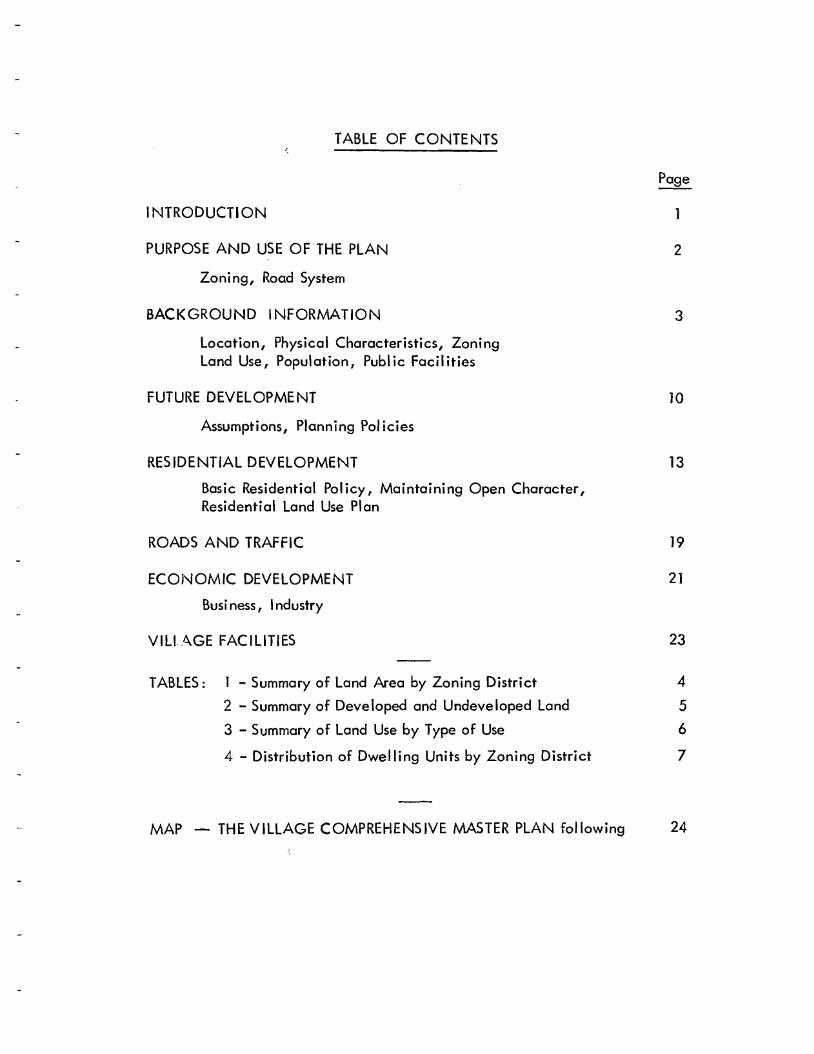
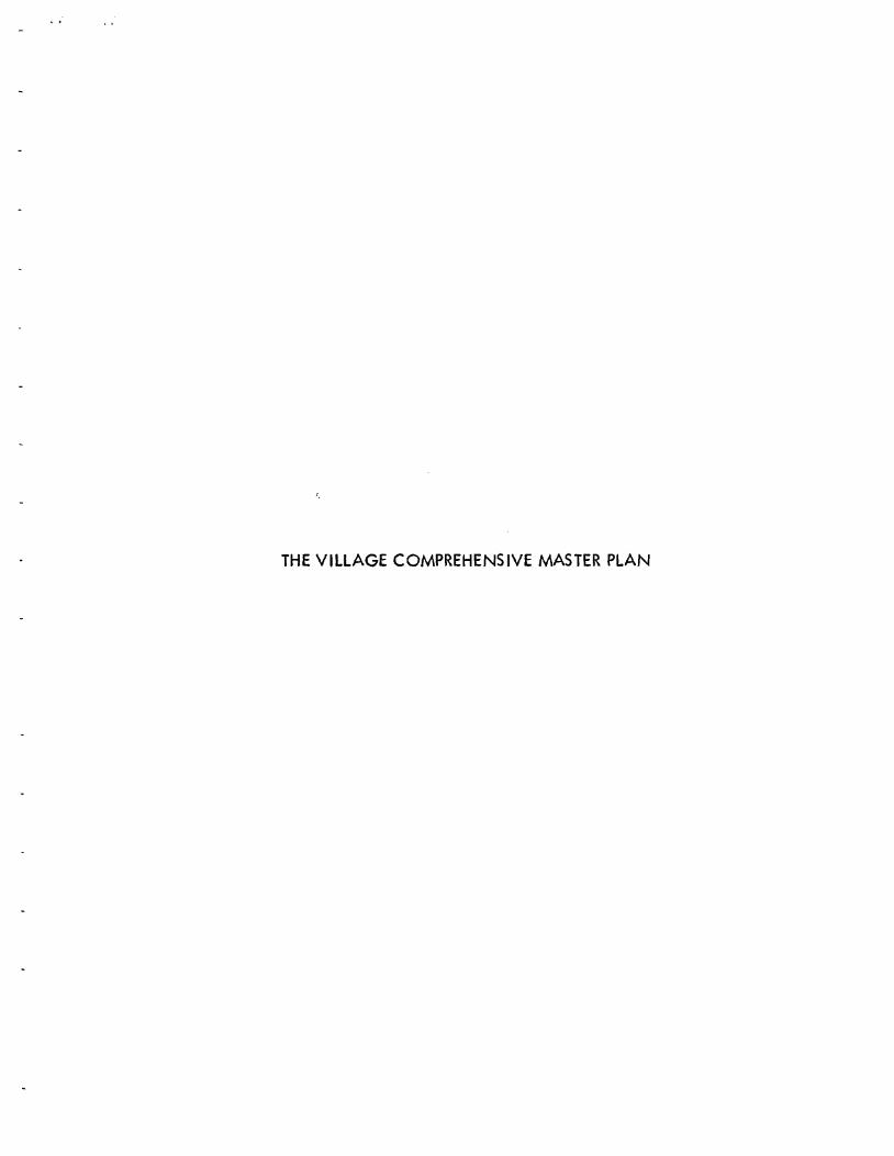
TABLE OF CONTENTS
INTRODUCTION
PURPOSE AND USE OF THE PLAN
Zoning, Road System
2
BACKGROUND INFORMATION
Location, Physical Characteristics, Zoning Land Use, Population, Publ ic Faci! ities
3
FUTURE DEVELOPMENT
Assumptions, Planning Pol icies
10
RESIDENTIAL DEVELOPMENT Basic Residential Pol icy, Maintaining Open Character, Residential Land Use Plan
13
ROADS AND TRAFFIC 19
ECONOMIC DEVELOPMENT Busi ness, Industry
21
VillAGE FACILITIES 23
TABLES: 1 - Summary of Land Area by Zoning District 2 - Summary of Deve loped and Undeve loped Land 3 - Summary of Land Use by Type of Use 4 - Distribution of Dwelling Units by Zoning District
4 5 6 7
MAP - THE VILLAGE COMPREHENSIVE MASTER PLAN following 24
INTRODUCTION
The Village of Muttontown is at a critical point in its history. It, together with the neighbori ng Norj·h Shore vi Ilages, represents the only substantially open area remaining for development in Nassau County, and, if the County is to con-tinue to grow as it has in the past years, this North Shore area is the principal place where this development must occur.
Nassau County tripled in population in the 1940-1960 period, gaining about 880,000 in population. The Regional Plan Association estimates that in spite of the relatively small amount of land remaining open for development i the County will gain almost a quarter million morE: in population by 1985. In the Regional Plan Association's 1957 report, PEOPLE, JOBS AND LAND 1955-1975, it states that "vir-tually all of the land now available for development in the County will probably be utilized in the next twenty years. In other words, Nassau should become fully satur-ated before 1975, with few open tracts left for development. •• • The forecast as-sumes that the 25,000 acres in private estates located in the North Shore area will continue to decrease as owners grqdually yield to continuing population pressures ••• "
The above pictures" dramatically, the pressures the Village and its neighbor villages will have to meet. The critical position of Muttontown is seen by the fact that the intensive development of residence, business and industry has now moved up to the Village's southern boundaries.
The Village has decided that the l"ime has come to reconsider its plan for the guidance of its future development, because such planning can give major assistance to the Village in resisting pressures for development that might be undesirable fiom the standpoint of the Village's long-term objectives. As development p:-essures in-crease in the County, and 03 ������ having property that could be developed see the opportunities for capitalizing on development opportunities, an increasing number of them will beseech the Village Board for chang'-ls in zoning to provide for an increased density in development and ��������� types of development, uS'Jally non-residential. It is the purpose and function of the Village Comprehensive Master Plan, hereinafter called the Plan, to indicate, to the ���� of ils ability, in what way o;,d where the Village should develop for varioL's types and intensHies of use5.
PURPOSE AN.D USE OF THE PLAN
The Plan is authorized by Section 179-gg of the Vi Ilage law. Under this Section, the Planning Board may prepare and adopt a comprehensive master plan showing its re-commendations for the development of the entire Village, which may include desirable land use districts, streets, parks, public reservations, sites for public buildings, and other features of public interest, all designed to provide for the future growth, protec-tion and development of the Vi lIage. Whi Ie the Plan itself is basically advisory in nature, it is used in connection with Vi Ilage activities where important decisions must be made.
Zoning
The Plan provides a comprehensive basis for zoning actions by the Board of Trustees, Planning Board, and Zoning Board of !\ppeals. At the present time, the Village has a Zoning Ordinance. This Ordinance states the regulations which now apply to the use of property within the Vi Ilage. However, this Crdinance can be amended in the future as it has been in the past. When applications are received for zoning changes, the Vi lIage Board must decide whether or not to grant the amendment. In considering such changes, the Vi lIage Board asks the advice of the Planning Board, which must decide what to recommend.
At the present time, the Village relies upon its comprehensive zoning ordinance, adopted in 1932, as an expression of its land development policy. The Zoning Commission, appointed to develop and formulate the origina I zoning ordinance, considered many of the same elements used to develop this Plan. The original Zoning Ordinance is actually an in-formal master plan which expresses in general terms the aims and desires of the Vi lIage in regard to its character and the nature of its development. This comprehensive master plan, in addition to considering those factors considered by the Village's Zoning Commission, not only provides a clear policy statement concerning the intensions of the Vi Ilage with respect to its future development, but also specifically outlines guides concerning the location of new roadways, pad,s, recreational areas and other municipal foci lities. This development policy will be implemented in many ways, by public and private action, and in accordance with the Village zoning ordinance and other development regulations.
Road System
As each individua I property in the Vi lIage is developed, land subdivision may take place and new roads may be buIlt to serve the house lots which are created. Under the Vi IIage law, the Planning Board must pass on each proposed developm(mt to determine that it meets Village standards and requirements. It is in this fashion that the Village road system gradua lIy comes into being and other characteristics of the Vi lIage's environ-ment are crystalized.
The Plan will be most useful in giving an overall view of the future road system into which the individual r,oad segments ������ best fit, when viewed in the context of Muftontown's future environment.
2
BACKGROUND INFORMATI0N
The Loca tion of J\'uttontown
The Vi Ilage of i'.Juttontown is one of the severa I rura I residential communities in the Town of Oyster Bay on the North Shore of Long Island. Most of its six and a quarter square mile area lies between two major east-west arterials, the North Hempstead and the Jericho Turnpikes, which provide for good access to the surrounding metropolitan area. East Norwich-Jericho Road (N.Y.S. Rte. 106) forms a connecting link between the two main highways, as it crosses the Vi Ilage from northeast to southwest. This road is intersected midway by Muttontown and East Woods Roads which join the Brookville-Jericho Highway on the west with Split Rock Road to the east. The overa II effect of this road network is to divide the Vi Ilage into four large sec-tions, generally oriented in the four compass quadrants.
Muttontown is one of the southern tier of North Shore vi Ilages which have, so far, re-sisted incursions of the high density deve lopment which has taken place in centra I and southern long Island. The northern edge of this intensive development is evidenced by the high density residential, commercial and industrial uses on the south side of Jericho Turnpike, a long the Vi Ilage's southerly boundary, and the expanding ham lets of Syosset and locust Grove.
The Village is essentially residential in character, and its inhabitants utilize the already provided shopping, cultural and recreational facilities conveniently located in surrounding areas. Residents who commute by rail to New York City use the stations of the long Island Rai Iroad in Syosset, Manhasset, Hicksville or Greenva Ie, depending on which is most con-venient. Housewives shop in East Norwich, Syosset, or other nearby centers for groceries and other convenience type goods and services. For larger, less frequent purchases, the excellent regional road network in this part of Long Island makes travel to many of the major shopping areas an easy matter. Access to schools, recreational and cultural facilities is equally convenient.
Physica I Characteristics
The Village is divided into two major watershed areas by the ����� line of the glacial moraine which runs a long the northern shore of Long Island. Because of the porosity of the glacial material, rainfall sinks into it rapidly' except where decaying vegetation has collected in small depressions, or where there are clay deposits, creating ponds which drain slowly by seepage and evaporation. Permanently flowing streams are not common in the area. North of the ridge line, which runs roughly parallel to and to the north of :"uttontown and East Woods Roads, storm water drains toward Long Island Sound; to the south of the ridge line, toward the Atlantic by way of the East f\/1eadow Brook drainage system. The few ponds in the Village constitute well less than 1% of the total area.
How The Vi Ilage is Zoned
The Village is divided into four zoning districts: Residence A-1, two acres per lot; Residence 1\-2, one acre per lot; Residence ����� one-half acre per lot; and Economic De-velopment, a limited commercial-industrial district requiring three acres per lot. The two-acre ��������� district is by far the largest, including more than nine-tenths of the area of the Vi lIage. Most of the one-ha If acre zones are located in the southerly and southeasterly parts of the Vi lIage where, in large part, they form a transitiona I zoning district adjacent to the more intensively developed unincorporated area of the Town of Cyster Bay. 'Jne other half-acre residence zone abuts the southerly edge of the settled area of East Norwich in the north-easterly part of the Vi Ilage. Less than one percent of the land in the Vi llage is zoned for non-residentia I uses. The area in each zoning district at present is listed in the following table.
Tab Ie 1
Summary of Land Area by Zoning District Vi Ilage of ",',uttontown, N. Y .
Zoning District Gross land ,L\rea
in Acres Area of District As
% of Total land /\rea
Residence A-1 (2 ������� Residence A-2 (l Acre) Residence A -3 0/2 Acre) Economic Development
3,655 58
273 20
91.3 1..£1, 6.8 0.5
L} ,006 100.0%
Source: Existing Zoning Map, 1964. Sca Ie ill =400·. Areas measured by plan imeter .
How ��������������� Land Is Used
A major difficulty in analyzing the use of land in a low density residential community, such as i"\uttontown, is to separate developed from undeveloped land in those instances where the parcel exceeds the minimum lot area for the zoning district. For the purpose of this report, such land in excess of that required to comply with the zoning requirements has been classified as "undeveloped,1I since it may be considered as potentially developable in the near or far future, even though the owner may have no present intentions of taking such action.
P, complete survey of the use of land in the various parts of the Vi IIage was made in August 1960. At that time, the Vi Ilage was less than one-third developed. This land use
4

information was brought up to date by field survey in May 1968. Since the original survey, several significant changes have taken place.
Developed land in residential use has increased about 20%. Most of this development has occurred in the 2 acre zoning district. Property in the southwest portion of the Village is presently being developed in half acre lots. Nassau County has acquired the 242 acre Christie Estate, in the center of the Village, for County park purposes, and the McKay property, approximately 50 acres which abuts the County park site to the north, has been dedicated as the Muttontown Nature Preserve. In addition, the reconstruction of N. Y. Route 106 through Muttontown has been completed and the Village's industrial lands are committed to develop-ment. Even so, the total effect of this new development has been to reinforce the general character of Vi lIage land as that of a low-density, residential community.
Table 2
Summary of Developed and Undeveloped Land
Village of Muttontown, N. Y.
Land Developed Undeveloped Area Area* Area
Zoning District (Acres) (Acres) (Acres)
Residence A-1 (2 Acres) 3,655 1,891 1,839 Residence A-2 (l Acre) Residence A-3 H Acre)
58 273
13 30
45 243
Economic Development 20 20 0
Totals 4,006 1,954 2,127
Source: Existing Land Use Map, August, 1960, updated by field survey in May 1968 and by discussions with Village and County Officials.
Scale 1" =400'. Areas measured by planimeter.
* Includes street rights-of-way, golf courses, public parks and permanently dedicated open space. See also discussion of "developed land" above.
The basic land use in the Village is residential, but of the approximately 1,950 total acres presently considered developed, slightly less than half is devoted to non-residential uses, such as roads, golf courses, public buildings, and other public facilities and recreation areas. The following table shows how land was used at the time of the updated field survey of land use in May 1968.
5
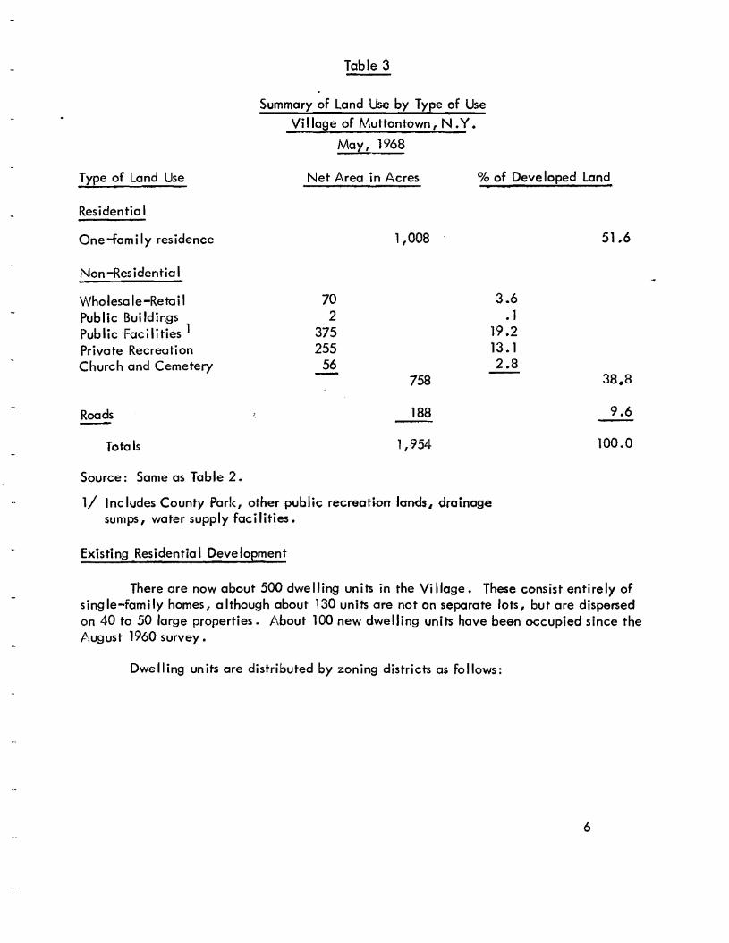
Table 3
Summary of Land Use by Type of Use Village of Muttontown, N •Y •
May, 1968
Type of Land Use Net Area in Acres % of Deve loped land
Residentia I
One -fam i Iy res idence 1,008 51.6
Non-Residential
Wholesa le-Retai I Public Bui Idings Public Facilities 1 Private Recreation Church and Cemetery
70 2
375 255
56 758
3.6 . 1
19.2 13. 1 2.8
38.8
Roads 188 9.6
Totals 1,954 100.0
Source: Same as Table 2.
1/ Includes County Park, other public recreation Ic:rnds# drainage sumps, water supply foe i1ities •
Existing Residentia I Development
There are now about 500 dwelling units in the Vi Ilage. These consist entirely of single-family homes, although about 130 units are not on separate lots, but are dispersed on 40 to 50 large properties. j.\bout 100 new dwelling units have been occupied since the J\ugust 1960 survey.
Dwelling units are distributed by zoning districts as follows:
6
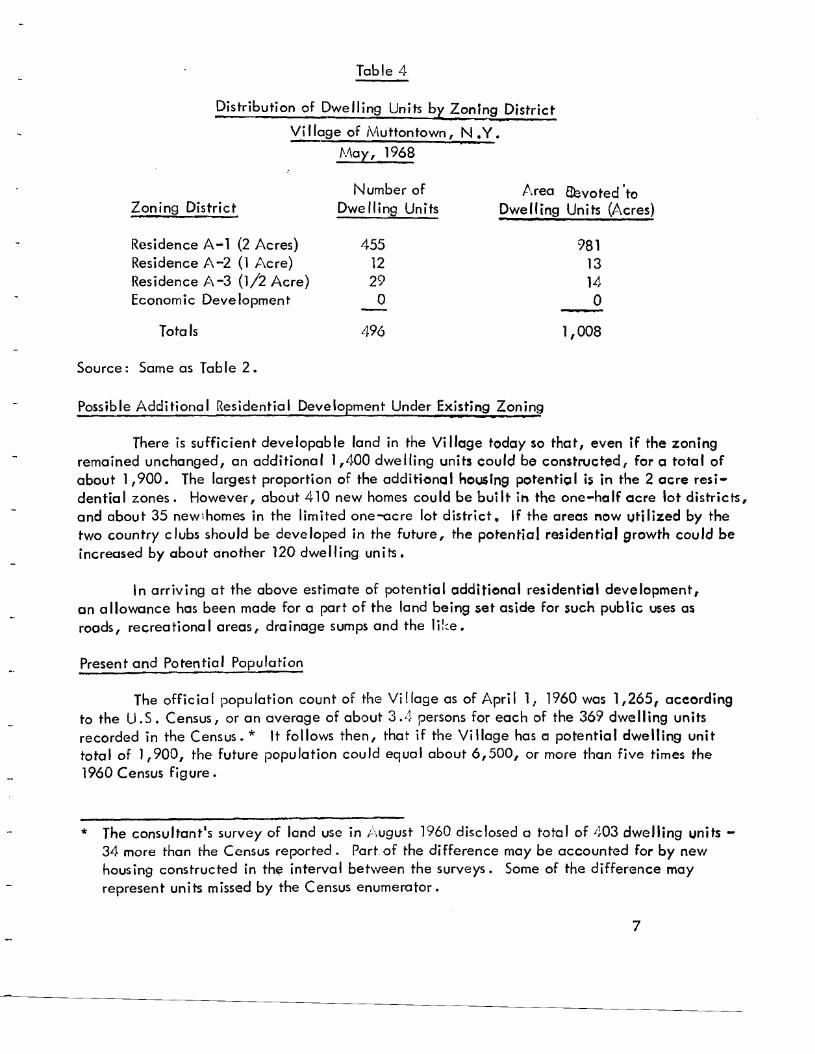
Table 4
Distribution of Dwelling Units by Zoning District Village of Muttontown, N.Y.
N\ay, 1968
Number of Area &voted'to Zoning District Dwelling Units Dwelling Units (A.cres)
Residence A-1 (2 Acres) 455 981 Residence A-2 (1 Acre) 12 13 Residence A-3 (1/2 Acre) 29 14 Economic Development o o
Totals 496 1,008
Source: Same as Table 2.
Possible Additional Residential Development Under Existing Zoning
There is sufficient developable land in the Vi IIage today so that, even if the zoning remained unchanged, an additional 1,400 dwelling units could be constructed, for a total of about 1,900. The largest proportion of the additional housing potentic;;d is in the 2 acre resi-dentia I zones. However, about 410 new homes cou Id be bui It in the one-he If acre lot districts, and about 35 newlhomes in the limited one-acre lot district. If the areas now utilized by the two country clubs should be developed in the future, the potential residential growth could be increased by about another 120 dwelling units.
In arriving at the above estimate of potential additional residential development, an a lIowance has been made for a part of the land being set aside for such public uses as roods, recreational crees, drainage sumps and the ������
Present and Potential Population
The official population count of the Village as of April 1, 1960 was 1,265, according to the U. S. Census, or an average of about 3.4 persons for each of the 369 dwelling units recorded in the Census. * It follows then, that if the Vi Ilage has <:l potential dwelling unit total of 1,900, the future population could equal about 6,500, or more than five times the 1960 Census figure.
* The consultant's survey of land use in August 1960 disclosed a total of 403 dwelling units - 34 more than the Census reported. Part of the difference may be accounted for by new housing constructed in thl? interval between the surveys. Some of the difference may represent units missed by the Census enumerator.
7
It should be emphasized that the 6,500 population figure is not a population forecast but an indication of the maximum population growth that could eventually take place under the terms of the existing Zoning Ordinance, and which should be taken into account in plan-ning Village facilities and services. Future changes in zoning densities, types of land use, and sizes of families, could of course alter this figure.
It is interesting to note that according to the U.S. Cenws, the Village population in-creased to 1,657 in April 1965, or over 30 percent in five years. If new growth activity continues at that rate, the Village population will double in twenty years.
Existing Publ ic Foci lities
Schools: The Village lies in four public school districts: Central #2 (Syosset-Locust Grove); Central #3 (Brookville-Locust Valley); Central #6 (Oyster Bay-East Norwich); and U.F.S.D. #15 (Jericho). . There are no public, parochial or private school facilities in the Village itself, however. Bus trcmsportation is provided to the public schools in the neigh-boring communities. A number of these schools are located along the periphery of the Village; these include the Brookville School on Remsen's Lane, the Cedar Swamp Elementary and Jeri-cho Junior-Senior High Schools on Cedar Swamp Road, and the Mabel G. Fox and James Vernon Elementary Schools in East Norwich. The Central #6 District has acquired an approximately 20 acre school site immediately south of East Norwich abutting and west of Route 106, but there are no plans for its development at this time.
Village Hall: The Village owns and maintains a Village Hall-Police Court on a parcel of land off the East Norwich-Jericho Highway, north of East Woods Road. This building, with its accessory buildings, grounds and parking, occupies approximately two acres. The day-to-day functions of Village government are conducted in the homes of the Vi lIage officials; the Pol ice Court building is used primarily for meetings of the Village Board and other Village agencies.
Fire and Police: The Village is served by four volunteer fire districts - East Norwich on the north; Syosset on the east; Jericho on the south; and Glenwood landing on the west. There are no fire houses within the Village. The Village of Muttontown has joined the neighboring villages of Brookville, Old Brookville, Upper Brookville, and Matinecock, to provide joint police service on a contract basis. The central police station is located at the intersection of the Brookville-Jericho Highway and the North Hempstead Turnpike.
Public Water Supply and Sewage Disposal: The supply of public water is furnished to Vil-lage residents through the mains of the Jericho Water District with offices in Syosset. The District's mains are located along the major roads of the Village, making the extension of public water to buildings in new developments relatively easy. Fire hydrants are also available along these water mains. There is no public sanitary sewer system in the Village. For the most part, disposal of sewage is by individual septic tanks for each property. This method has generally proved adequate for the waste disposal requirements of low density residential development. The new half acre residential development in the southwest portion of the Village has unique soil conditions which require a central sewerage disposal system. If there should be a change in land use policy which might bring about concentrations of higher density residenti(JI or commer-cial-industrial uses, there may develop a requirement for a more comprehensive method of sewage treatment to protect against contamination of the water supply. Eventually,
8
a County trunk sewer may be constructed along the Jericho Turnpike thus offering opportunities for public sewers to some of the adjacent Village lands.
Storm Water Drainage: Storm water runoff, where it can be collected, is used to " re -charge" the supply of fresh water-bearing strata underlying Long Island. The storm water is drained to natura I or man-made ponds, known as sumps or recharge basins, and is a Ilowed to percolate down into the aquifer. ',''!ithout such replenishment of fresh water, the aquifers would become contaminated by salt water seeping laterally from the Sound and the ocean to replace the less dense fresh water being yvithdrawn from the strata for public use.
Public Recreation and Cpen Space: Nassau has recently acquired the 250 acre Christie estate near the center of Muttontown fronting on the Jericho-0yster Bay Road and (\/uttontown Road. /\ plan for the deve lopment of the park, prepared by the County Depart-ment of Parks with review by the Vi i lage, indicates its use for re lative/y quiet types of re-creationa I activities. These inc lude an equestrian area, with riding trai Is throughout the entire parki a camping area for use of organized groups such as the Boy Scoutsi and a re-production of an operating dairy farm. A small area will be devoted to park administrative and maintenance use.
The periphery of the Robert G. Mc;Cay estate has been designated and established as the Muttontown Nature Preserve. This approximately 50 acre parcel abuts the county park site and stretches northward around East Norwich to the North Hempstead Turnpike. This property will ultimately be available for nature study.
The value of both the County park and the Nature Preserve wi II continue to grow as more and more land becomes developed in the Village. Not only will it provide facilities for active recreation but it wi II he Ip significantly to preserve the low density character of /\!\uttontown's present development.
Two private golf courses within Muttontown also help to preserve the Vi lIage's open space. These uses cannot be considered as permanent open space however, and the Vi Ilage may some day be required to adopt a policy as to their preservation as pressures for land de-velopment increase.
The Vi Ilage is fortunate that severa I major recreational attractions are within con-venient driving distance of its resideni's. The rr.ost pO[Jular include Jones Beach, [3ethpage and Sunken IVeadow State Parks. However, sl.J<..h Stal'f) fdcilities are often crowded, since they serve a large part of the metropolitan population. /\ctually, it is likely that a large part of the Village residents rely on private clubs and facilities for their recrcJtional needs. The Town of ryster Bay maintains several bathhg beaches along Long Island Sound, between Hempstead and Cold Spring Harbors. /\Ithough these are intended for Town residents, they are a Iso in heavy demand by the seasona I occupants of the summer cottages a long the North Shore.
For the naturalisi', there is q bird sanctuary adjacent to the westerly boundary of the Vi lIage, opposite the intersection of the Brookvi lie-Jericho Highway and tv'.uttontown Road. There are other wi Id/ife sanctuaries in': len Cove, and l'he Vi lIages of i'/Iatinecock and /\':i II Neck. Recently, a large segment of ';he North Shore wetlands was dedicated to the U.S. Department of Interior under the Federal i\ "igratory Bird and Game Act.
9
FUTURE DEVELOPME NT
The preceding brief summary has outlined the existing features, facilities and develop-ment of the Village. The Plan has been discussed in preliminary form with the Planning Board and the Board of Trustees. Based upon these discussions, basic assumptions and policy decisions have been reached with respect to the fundamental objectives to be sought in the gradual development of the Village.
Assumptions
The Village of Muttontown is part of a larger area both on Long Island and in the metropolitan region, and many of the influences which will tend to shape the future develop-ment of the Village will come from this larger area. Since the Village of Muttontown obviously has no control over the development outside of its limits, it becomes necessary to make certain reasonable assumptions with regard to developmental trends in this larger area. These are outlined below.
1. The New York Metropolitan area will continue to grow in population and economic activity. Current forecasts indicate that the metropolitan area may have about 7,750,000 additional population and about 2,700,000 more jobs in the next 25 years, most of which growth will take place in the suburban areas. The Regional Plan Association estimates that about 1,500,000 of this population growth, and per-haps 450,000 additional jobs will be in Nassau and Suffolk Counties.
2. The Village of Muttontown is one of the nearest areas to New York City still having a large amount of land suitable for future development. In fact, the Village is one of the ��� parts of the primary area (North Shore) remaining for future expansion in Nassau County. Therefore, the Village can expect, in the future, to experience growth at a proportionately greater rate than that of most other communities in the metropolitan area, and can expect increasing pressure to allow more intensive development, particularly since, on its southerly boundary, it directly abuts the edge of this mass development.
3. Nassau County development already provides a wide range of housing environments, predominantly in the sl11all lot categories, and the maintenance by the Village of its present low density residential policy helps in assuring a desirable variety of residential choices in the regional housing market.
4. Adequate areas for busi ness deve lopment, needed to serve the future growth of the area, already exist in developed and in zoned areas in the communities surrounding the Village. Therefore, the provision of areas for business development within the Village would be based upon the suitability of fand for a particular type of land use, rather than upon any need to serve the surrounding area. Conversely, the need for business development areas within the Village to serve the needs of the residents does not exist.
5. An increasing number of employment centers will be located on Long Island, and an in-creasing proportion of the Village's residents will work in such establishments. However, the number of persons commuting to New York City will continue to be large.
10
6. -rhere wi II be a substantial increase in automotive traffic both through and within the Village, due to increased population and increased car usage, both within the Vi Ilage and in the surrounding area.
Planning Policies
Practical planning for the future development of the Village should reflect the views of the people of the Vi lIoge. Whi Ie it is true that the population of any community changes over the years and that this will result in diHerent attitudes towards the Village's develop-����� it is believed that a substantial agreement on the type of Village development that is desired hos been established. The planning policies below are suggested as probably repre-senting the consensus of the Vi Ilage residents.
1. Every effort should be made to maintain a predominately residential community, and to maintain the high standards of residential development that are now characteristic of the Village. \\lherever necessary, present zoning standards should be improved and clarified so as to protect the character of the Vi lIage l s residentia I areas.
2. Residential development should continue to be predominately of a low density. While some areas might be planned for lower density and others for perhaps higher density, the present overall character of two acres per family should be maintained.
3. In order to help preserve the open space character of the Village, to sustain the attractiveness of the present environment and thereby to support the economic viability of its residential areas, the preservation of open space is an important function of Village planning. The maintenance of open space will help provide for the recreationa I and aesthetic needs of Vi Ilage residents and wi II ensure an element of variety in the residential development and environment of Nassau County and the region of which it is a part.
4. The system of roads should be planned to handle conveniently and safely the sub-stantial increase in traffic that wilt accompany the growth of the surrounding area and the Village. Rights-of-way of roads should be adequate in width and alignment to accommodate future traffic requirements. However, Vi IIage roads should not be expected to handle any large increase in through-traffic. To rebuild them for this purpose might tend to destroy some of the essentia I charm of the Vi IIage. In general, new local streets should be laid out so as to serve conveniently the uses a long them, but not so as to encourage through-traffic. Among the techniques to be employed to discourage through traffic would be the use af dead-end streets and the orientation of through, local streets, so that they do not conveniently align with other through streets.
5. Through-traffic routes crossing the Village should be so located and 50 designed that they will result in a minimum of disturbance to existing residential development. Their design should be properly related to the existing and future street system of the Vi Ilage, and rights-of-way should be adequate in width to a Ilow for substantial land-scape screening next to abutting residential areas.
11
6. All non-residential uses should be located on, or have direct access to, main high-ways so that it will not be necessary for traffic going to and from such uses to proceed through local residential streets.
7. At the present time, the Village is largely undeveloped, having a substantial number of estates. It must be assumed, as time passes, that many of these estates will be replaced by new development which, even though at a low density, will gradually give the Village a built-up appearance, strikingly changing the present rural or open character of the area. Consequently, methods wi II be employed, through land and easement acquisition, development regulations and other means, whereby some of the present open character, parti cu lady a long existi ng roads, may be preserved.
12
RESI DENTIA l DEVE LOPMENT
Basic Residential Policy
The Plan is based upon a continuation of the present low-density residential planning policy. /\s pointed out earlier, only a small part of the Village has been developed in accordance with this policy to date (two acres per family), the large part still remaining in residentia I parce Is of substantia I size. The pleasant, ruro I atmosphere of the Vi Ilage is due in large measure to the very low density of development. This low density is reflected in the open spaces, the broad open meadows and the dense Iy wooded hi lis that characterize the tv\uttontown landscape.
However, this openness will change - it cannot remain the same -as the Village continues to develop. In the early part of this decade, the ratio of acres of land to fami lies was about 10 to 1; in just a few years, this overall density has been reduced to aacres per family. IVlore subdivisions will be created, houses and roads "'Viii be constructed, and the woods and fields will become residential neighborhoods as the Village approaches the overall residential density of two acres per fami Iy provided for in the existing Zoning Ordinance. The objective of maintaining a pleasant open residential character as the Village advances towards its ultimate population and redevelopment under the Plan is of fundamenta I importance.
The continuation of the zoning patterns created by the Village's Building Zone Ordinance is essential to maintain the rural characteristics of the Village. Any effort to promote higher density zoning in the Vi IIage would cause the destruction of many natural and ecological resources and create additiona I burdens on municipal and educationa I facilities in the area.
In consideration of residential planning policy, it cannot be overlooked that Muttontown is in the "frontier" area. It, together with Old Westbury and Brookville, faces the mass housing development of Nassau County to the south of Jericho Turnpike, a situation not faced by the villages to the north. Consequently, to foster variety in the residential character of Nassau County, t\"\uttontown's residential planning policy should be based upon maintaining and strengthening I"he basic two-acre density pattern established in its zoning 36 years ago.
Larger lot zoning (2 acres or over) is in close harmony with the pri::lr development of large estates in the Vi Ilage. tv'·any of the mansions which are located on estates presently being subdivided blend in well with the homes on newly created 2 acre lots. The place-ment of large homes of this type in the midst of smail residential lots, e.g., 1/2 acre, 1 acre, would create aesthetic unbalance, would tend to depreciate existing property values, and would adversely affect the residential character of the Village.
13
In the reg iono I context, Muttontown and severo I of its North Shore ne ighboring municipalities provide an element of variety and relief in the development character and environment of much of Long Island. Considering the rapid growth of the New York area and the increasing awareness and concern of many (citizens and professionals alike) for our living environment, the role which !I/iuttontown and its neighbors play in the provision of an open, semi-rural atmospher.i; is becoming increasingly important.
The attitudes of the residents of the Vi Ilage should be, and is, the most significant factor to be considered in regard to the future development of J\luttontown . .It has been determined that many new residents have moved to the Village for the sole purpose of getting away from traffic, noise, fumes, and crowded living conditions that are character.. istic of New York City and the high-density areas of Long Island. The pressing need to pre. serve the irreplaceable natural features of the Village is important not only to its citizens and its officials but also to the residents of the entire North Shore of Long Island.
All of the above factors, which not only have local but regional significance, have been considered in arriving at the present development policy.
Maintaining ',pen Character
Most of the land in the Vi lIage is currently used in a manner quite in contrast to the two-acre home development pattern authorized by its present zoning policy. For that rna tter, even a 3 or 4 ac re per home deve lopment po ttern wou Id be qui te d iHeren t from the present character of most of i\i\uttontown. Since the predominantly two-acre residential density currently in force is to be retained, other methods may be considered to keep a reasonable measure of the open character presently possessed by the Vi lIage. Some of the possibilities are discussed below.
1. Purchase of Land. The most obvious and usual method of keeping land open is through purchase. It does not need to be discussed further here other than to note that land investment is practiced by many communities in the New Yorl< area.
2. Purchase of an easement limiting the deve lopment of land. Since one of the basic purposes is to maintain areas inan open and at least relatively undeveloped condition, this objective could be achieved without cctual purchase of the land itself. r ne of the oldest of practices is that involving the acquisition of an "easement" in a piece of land, giving the public Some right over the use and development of private land. There are slope easements, drainage easements 1 air rights, sight distance easements, scenic easements along highways and parkways, and other types of easements. This is today considered one of the most useful of methods that could be used in reserving open spaces. For example, an area of land might be maintained in farm or forest use, or in its natural state by agreement with the owner. The price of such an agreement might be the difference in value of the land when so limited as contrasted with its value if developed. The State of New Yor!( has recently authorized municipalities to purchase or ��������� acquire such easements.
3. Acquisition of land bygift. This is, of course, an old and honored method. Many of the reservations and parks in the metropolitan area have been set aside as gifts, either to government agencies or to semi-public organizations, tbe latter usually
14
established for the purpose of administering such areas. The Muttontown Nature Preserve is an excellent example of this method.
Gifts of scenic easements and development rights are again often more appropriate than actua I fee acquisition. Such a procedure usually reduces the tax burden upon the land owner, while ensuring the particular scenic or open space value of the lands involved.
4. Regulation of design and deve lopment. Considerable significant recreation and open space can be preserved by the use of development controls available through subdivision review and zoning. The Vi lIage subdivision regu lations provide the opportunity to create residential areas which preserve unique physical features, such as an excellent view or a stand of trees. The regulations state that land subdivision plans shall show "a park or parks suitably located for playground or recreation pur-poses." The regulations also call for reservation of land in new subdivisions to pre-serve existing natural features, such as "large trees, wooded areas, water courses, ponds, historic sites, vistas, or other irreplaceable assets" where the Planning Board finds they will enhance the attractiveness of the subdivision and add value to the development of the Village. Up to 10% of the land in subdivisions can be reserved for recreation purposes of all sorts.
In some instances, it may be appropriate to require the reservation of open space along the fringes or edges of development, e.g., open space strips in their natural state along major roads, or between subdivisions in order to preserve the open character of development in tvtuttontown. These lands might serve other purposes as well by preserving drainage-ways, providing better screening adjacent to drain-age sumps or non-residential areas, or providing hiking or riding trails.
5. Zoning. One relatively new zoning method of securing open space is to permit a aeveloper of land to develop part of his property to a higher density than ordinarily called for in the zoning ordinance, provided the ba lance of the property is retaIned as permanent open space. For example, a 50 acre parcel in a two-acre lot zone may have as many as 22 residential lots with homes, allowing for street area. Under the procedure mentioned, the developer might be permitted to locate the 22 homes on, say, two-thirds of his parce I, if the other third was placed in a park or other type of permanently reserved open space.
The Vi Ilage zoning regulations now permit certain lot size modifications in new subdivisi-ons so as tOobtain good subdivision design. This technique can be particularly useful in the creation of transition areas between zoning districts, by providing a strip of inter-mediate sized lots between two basic lot sizes. Other appropriate uses would be along major roads abutting non-residential uses, or along drainage or utility easements where deep or oversized lots might provide additional insulation from adjacent nuisances.
Since a substantial amount of the Village's development is still to occur, the review of appropriate subdivision design and zoning standards and techniques is an important element in the planning process.
15
u. Establishment by other levels of government. Several of the methods discussed above are of course also available for use by school districts, the Town of Oyster Bay, Nassau County, New York State and the Federal Government. The Village shall carefully evaluate any such proposal in order to weigh any open space and recreational advantages for Muttontown against possible problems of trespassing! vandalism, property damage and increased trdffic. For example, the County Park to be developed on what was the Christie Estate will do much to maintain open space in the Village. Unless access is restricted to the Jericho-East Norwich Road, future park patrons may add considerably to the traffic on local roads.
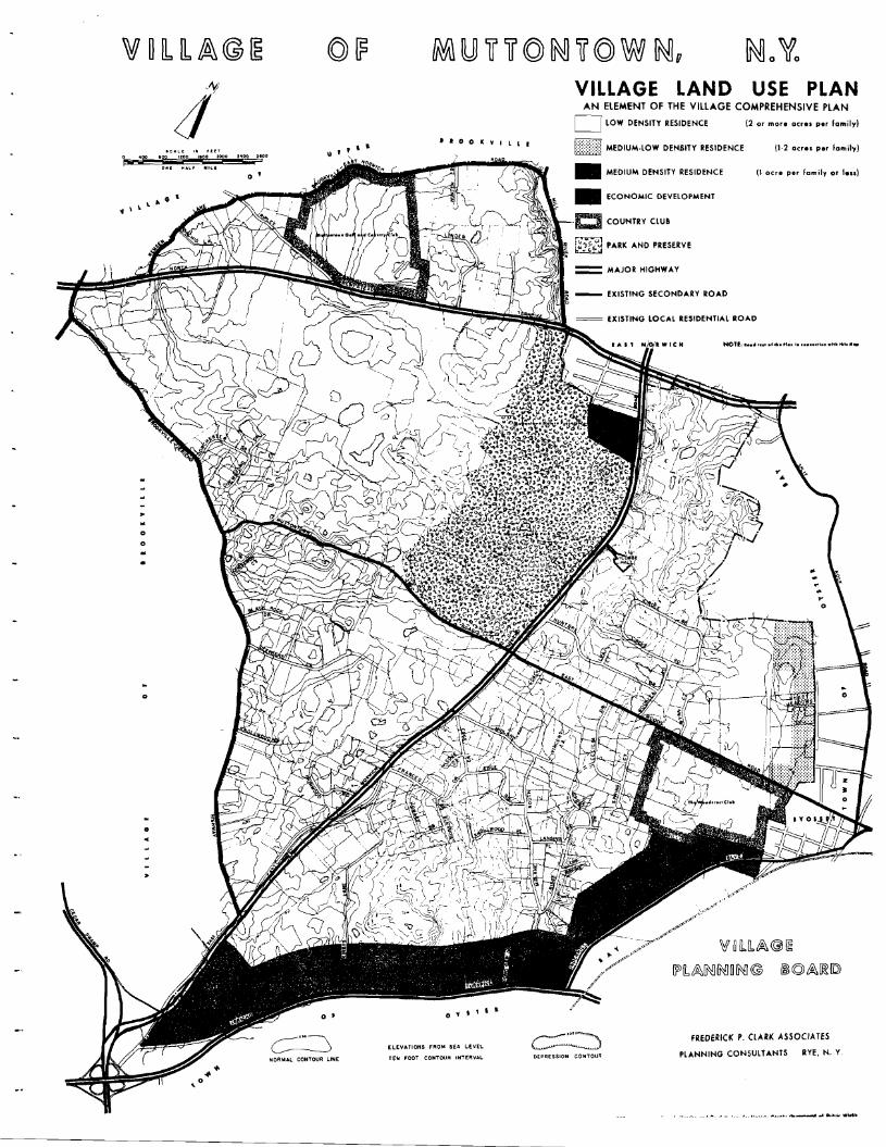
Residential Land Use Plan
Residential Densities: The purpose of the Plan, as it relates to residential land use, is to indicate the general distribution of residential population as expressed in families per acre. The Plan is not intended to fix the detai Is of residential zoning, either as to exact boundaries or exact densities and standards. These wi II be established and amended, as necessary, by the Board of Trustees as part of the Zoning Ordinance and �������� of the Vi Ilage. Therefore, the classifications of residential density shown on the Village Plan are not zoning districts, and the densities are expressed in average or overall terms, rather than as minimum standards. It is recognized that changing conditions may call for specific modifications in boundaries and standards, but the Plan, as adopted, should represent the broad policy that should hold in considering proposed modifications, unless and until, after careful study, the Village decides on a revision in basic land use policy.
The proposed classification of residential densities shown on the Village Plan is as follows;
"Low" density - Two or more acres per fami Iy.
"Medium-Low" density - One to two acres per family.
"Medium" density - Less than one acre per family, but generally not less than one-half acre per family unless in accord wi th a "clustering" type of development approved by the Vi Ilage .
It should be pointed out that the above described densities relate to residential use. The development of the Village includes and will include other related uses such as schools, clubs and churches. These types of uses, in practically all instances, require larger sires than do homes, and zoning standards should call for adequate space for each such specific use, not JUST the minimum zon ing lot area for a home.
Low-Density Area - This land use classification includes all the Village except for the lands a long the southeasterly and easter Iy boundaries wi th the Town, and a sma II area adjoining East Norwich. The more specific locations of these sections and their
16
recommended land use con be seen on the Plan map.
Medium-Low Density Areo - This density would apply to the area along the Village line abutting Syosset. It would extend from Willis Avenue on the south l"o a point about 3,500 feet north of East Woods Road.
Medium-Density Areas - I\reas to be developed at this density would be dfong Jericho Turnpike, Underhi" Boulevard, and immediately to the south of East Norwich. These are the most critical areas along the Vi lIage's boundaries. There must be on under-standing of the problem that exists due to the conflicting zoning policies of the Town and Vi Ilage, so that the Vi IIage can adopt the best possible plan, and work with firm-ness in maintaining the Plan it adopts.
There are a few who would have the Vi lIage drastically modify its half-ocre residential zoning along Jericho Turnpike to more nearly correspond with the intensive type of zoning in the Town area to the south. This type of proposa I has no merit in terms of a comprehensive plan for the Vi Ilage. It would result in moving the boundary line problem to a point north of Jericho ���������� rather than solving the problem. Actually, due to the existenceof trees, shrubbery and walls along much of the Village frontage on the Turnpike, this area has a degree of protection, both visua lIy and from the effects of noise, that the land on the south side of the Turnpike does not possess.
Severa I years ago study was given to the Jericho Turnpike frontage to determine whether the two-acre residential zoning should be modified. After this study it ��� agreed this area was suitable for residential development, but that the land near the Turnpike should be planned for smaller lot development. Consequently, for a depth of 1,000 feet, the land along the north side of the Turnpike was zoned for one-half acre residentia I use, except for the corner of Underhi" Boulevard which was classified for non-residentia I use.
At the same time, it was agreed that the Planning Board should have some flexIbility in planning new land subdivisions on the borderline between the one-half acre and two-acre zones. The Village Law permits the Planning Board to vary lot sizes in particular situations, provided the total potenl-ial number of house lots are not increased. For example, a subdivision in the one-half acre zone might have larger lots (say one acre) abutting the two-acre zonE:! rand r to compensate, might have sma lIer lots (soy one-quarter acre) near Jericho Turnpike.
It is recognized that I-he Village cannol" rely solely on its zoning ordinance in secur-ing good development. The manner in which roads and lots are laid out, particularly in this border area near Jericho ����������� wi II have at least as much bearing on the proper development of an area, as wi II the determination of lot sizes and bui Iding ���������� ror example, if this border area were to be developed with houses facing rhe Turnpike, it would be difficu It to secure a good residential development of these areas. However, if these border areas were developed facing upon interior roads with no direct access to the Turnpike (except for a few needed road connections) and with deep lots and a
17
landscaped buffer established along these roads where it does not a Iready exist, these could be attractive residential areas.
The problem along Underhi 11 Boulevard is not as difficult as that on Jericho Turnpike, due to the fact that the industrial development on the Town side of the Boulevard is new, non-nuisance in type, and more attractive in design. The principal problem is the lack of adequate parking in at least some of the industrial establishments. The Village should prevail upon the County or Town to restrict the Boulevard against all-day parking. The Village must be vigi lant with such matters involving problems creoted by abutting municipalities and, where appropriate, should call for action by appropriate authorities to alleviate such problems.
As pointed out above, the development of industry on the Vi Ilage side of the Boulevard would merely move the boundary problem farther into the Village, making the solution no easier there than at the present zone boundary. rhe Boulevard is a wide and recognizable district line that should be maintained.
18
ROADS AND TRAFFIC
In planning for the Village's future development, roads and traffic must be considered in two ways. In the first place, it is necessary that there be adequate access to all uses of land in the Village, and that movement from one place in the Village to another be as con-venient as possible. Since the Village builds no roads, it is essential that the road building by private land developers be so controlled that an inconvenient and costly hodge-podge of roads is avoided. A study of potential development under existing zoning indicates that the Village must contemplate that over 30 mi les of new streets will be establ ished eventually as a part of new residential development. How these many miles of streets are coordinated is of great concern to the Village.
The other aspect of roads of interest to the Village is that relating to service non-local traffic. Obviously, Muttontown is part of a larger urban area, and proper provision must be made for the movement of the traffic generated by the people of this larger urban area. Since many of the business, social and other activities of Muttontown residents take place outside the Village, local residents have a substantial concern in the adequacy of this regional traffic network. Of equal concern, however, is the handling of this non-local traffic so as to minimize its effects upon the future development of the Village.
The Village is well situated with respect to regional traffic arteries, with the Long Island Expressway and the Northern State Parkway close to its southern boundary, and the North Hempstead Turnpike in the northerly extremity of the Village. One of the principal north-south roads joining these east-west arteries, the Jericho-Oyster Bay Road, traverses the central part of the Vi Ilage. Jericho Turnpike abuts the southerly boundary of the Village; Underhill Boulevard, part of the easterly boundary; Brookville-East l'lorwich Road, Remsen's Lane, and Mill River Road its northerly boundary; and Brookville-Jericho Road its westerly boundary. The other important road in the Village is Muttontown Road, extending east-west from Syosset to the Brookville-Jericho Road.
The Stote has recently completed the modernization of Jericho-Oyster Bay Road, in-cluding a realignment to reduce curves, and a redesign providing for one-way traffic with two lanes on each side of a central mall. A major new interchange has been con-structed where this road joins Cedar Swamp Road and Jericho Turnpike to the southwest of the Village, The State has also rebuilt the intersection of Route 106 and North Hempstead Turnpike in East Norwich, together with about a mile of North Hempstead Turnpike through the hamlet. As constructed, this appears to have had a minimum impact on the Vi Ilage of Muttontovm. Future deve lopment along these mojor roads should be carefully controlled by the Villago to help maintain their safety and capacity.
A study of potential development in the regional area north of Jericho Turnpike indicates that there is no reasonable prospect that any new regional traffic route will need to be built through Muttontown. Both North Hempstead Turnpike and Jericho Turnpike can be expected to be rebuilt in the future along the lines of Jericho-Oyster Bay Road. Plans have now been prepared for the widening of Jericho Turnpike. These will place substantially all the widening on the southerly side of the roa.d outside the
19
Village. The character of Jericho Turnpike rebuilding can be seen just to the west of the Village. In the long run, with increased development in the central part of the Village and nearby areas, it may be necessary to improve Muttontown Road. However, this is a Village road, and the standards of any reconstruction would be set by the Village Board and should be designed to protect residential development along this road.
All new roads builT in the Village are likely to be strictly local in nature, built by de-velopers in connection with subdivisions of land. The layout, design and standards of con-struction for all these new roads will be set by the Planning Board operating under regulations approved by the Village Board. The Village is now equipped with a modern set of regulations to guide this development, due to work completed about eight years ago at the start of the Village planning program.
In many instances, it may be desirable and appropriate, from the standpoint of lessening traffic congestion and providing convenient travel within the Village, to provide for the ulti-mate interconnection between existing and/or proposed Village roads. One way to plan for these future connections is to require that the rights-of-way for these road connections be re-served at the time of subdivision plat approval, but that their actual construction be delayed until such time as their need i. evident. One example of this is the reservation of a connec-tion between Crest Road and Cecelia Drive, to be constructed when and if needed in the future.
Certain principles sho·"Jld apply in the design of this road system:
I. Roads should not have sharp curves or steep grades, but every effort should be made TO follow the natural topographic contours of the land. In this way, a combination of safety and attractiveness can be achieved.
2. Roads should provide for convenient movement from one part of the Village to an-other, but connections with main highways should be so located and designed that short-cut routes are not created for through-traffic.
3. Road design should take account of existing and possible future roads in abutting Village and Town areas.
4. Some of these new roads wi II need to be laid out as secondary roads providing con-venient travel from one part of the Village to another, and efficient movement of fire protection and police vehicles.
The existing elements of this road system are shown on the Village Plan. In locating future roads, consideration should be given to topography, as well as to the size and shape of property holdings, to make sure that the road locations will be practicable in connection with development of such holdings. As new development is proposed in the Village, the principles listed above should be used as a guide in the specific design of required streets.
20

ECONOMIC DEVELOP/v"ENT
Business
At the present time, there are only a few very limited business uses in the Vi lIage, and, fortunately, they are of such type that they fit rather unobtrusively into the residentia I character of the Vi Ilage. In fact, if it were not for identifying signs, most people would not know the uses existed.
Business centers for conven ience goods to serve the people of the Vi Ilage are located just beyond its boundaries at East Norwi ch and Syosset, and a long Jericho Turnpike. Large shopping centers in several Nassau County communities are accessible to Village residents within a few minutes drive.
PI study of the potential future growth of the Vi lIage indicates no need for the establishment of retai I business districts anywhere in the Vi lIage. Existing business centers close to l'Auttontownls boundaries serve the general area as well as would be done from a location in the Village, and the total potential population of the Village would not in itself justify the establishment of a new business district.
In some instances it may be appropriate to permit the establishment or continuation of commercial activities of such character that they are or can be made compatible with low density residentia I development. Such uses as farming, anima I boarding, horti-culture and recreotion or social clubs, to name a few, may be helpful in maintaining open space while sustaining the fiscal stability of the individual properties and the Village in general. All such uses should be reviewed by the Village before establish-ment, however, in order to insure their compatibility with surrounding development.
���������
The Village has slightly less than 20 acres (less than 1% of its total area) zoned in an Economic Development District classification. IV'ost of this area (almost 17 acres) is located at the northwesterly corner of Jericho Turnpike and Underhi II Boulevard. Somewhot over 10 acres of residentia I land adjoining this industrial area are used for re-lated parking, drainage, and landscape screening, in accordance with the Village Zoning Ordinance. A small, triangular piece of land, slightly more than 3 acres in size, ������� on the easterly side of Underhill Boulevard and extending to the railroad comprises the remainder of Muttontown1s industrial lands. This small parcel is the only part of the Vi Ilage east of Underhi II Boulevard, and the property adjoining it, in the unincorporated area of the Town of Oyster Bay, is zoned for industry and is in use for such purposes.
The large parcel at. the Jericho Turnpike corner has been the subject of intensive study by the Vi Ilage during the past several years, following the inclusion of this land within the Vi lIage boundaries when about 500 acres in this general area were annexed to the Village. The corner parcel had been zoned by the Town of 0yster Bay for
21
neighborhood business. Whi Ie the future zoning of the area and the annexation were being discussed, however, the owners of the property obtained bui Iding permits from the Town for two structures which were identified as "office buildings" on the approved plans. When work was started on footings for these bui Idings, construction was stopped cis a result of legal action by neighboring property owners.
In essence, the fundamental question facing the Village was whether the area was suited for residential use, and, if it were not, what type of zoning for the area would best protect the basic low-density residential development policy of the Village, particularly in the already developed abutting area. A careful study of the situation led to the conclusion that a change in the two-acre residential zoning in this corner area would be to the ad-vantage of the Vi Ilage as a whole, provided the area was subject to proper development standards and planning approval by the Vi lIage.
After public hearings the corner property was placed in a new type of zone, designated Economic Development District, varying in depth from 650 to 800 feet from Jericho Turnpike and permitting restricted non-residential uses under high standards (low-density, large set-backs, landscaped screening, etc.) designed to protect neighboring residential areas, as well as to secure well-planned development of the property itself. rhe zoning standards require that as a prerequisite to any development in this District, the specific plans must be submitted for the approval of the Planning Board, just as is required in the case of all residential developments in the Village. Legal constraints upon the development of this land have recently been removed and its development as a high quality office building complex is rapidly nearing completion.
Since the objective of the Village, insofar as Jericho Turnpike and the Boulevard are concerned, is to provide for a type of land use that will maintain and protect the Village's overall low-density residential land use policy, mention should be made of one other type of land use that might be suitable for this border area. This is the company headquarters or research center, located on a large lot (10-20-50 acres), with bui Idings covering very little land area (10 percent) with very large setbacks, and with attractively designed buildings and landscaping. Such a type of use would make a good neighbor to low-density residential areas. There are several outstanding examples in V/estchester County, Connecticut and New Jersey.
If an interest develops on the part of companies to establish such low density facilities in Nassau County, the Village might consider specific proposals as alternatives to the half-acre residential use along the Turnpike and Boulevard.
22
VILLAGE FACILITIES
The various public facilities presently serving I\iuttontown are discussed earlier in the Plan. The following additional facilities are considered appropriate for future Village ac tion .
Storm Water Drainage. The Vi Ilage's consulting engineer has prepared a compre-hensive plan designed to solve the many drainage problems which wi II be encountered as the Village develops. In order to preserve the natural beauty of the land, the drainage plan contemplates the use of natural ponding areas with a minimum of large drainage pipes and related facilities. The concept calls for each subdivider of a tract of land to solve his own drainage problems.: within his own development, with the drainage facilities in each individual subdivision becoming part of a larger system that will eventually be complete as the Vi Ilage is deve loped.
In view of the importance of protecting the attractiveness of the Village, the pro-posed plan seems to offer substantia I advantages to the Vi lIage. The proposed plan is in preliminary form and wi II need to be designed in detai I to fit subdivisions as they are presented to and acted upon by the Planning Board.
Vi lIage Park and Recreation. As the growth of the Vi lIage increases and the open spaces diminish, it may become desirable to provide park and recreation facilities for the use and enjoyment of Vi lIage residents. Fortunately, the recently established large County Park will help meet the needs of Muttontown's population. But this Park will have specific re-creation functions and will be used by the entire County. Consequently, its specific use by Vi lIage residents may be somewhat limited. V,Jhi Ie many Vi lIage residents a Iso use private clubs for recreational activity, experience indicates that an increasing number of people will need public recreational facilities since there is a limit to the amount of membership expansion that clubs can handle without overcrowding and destroying some of the value of the club. In addition, the growth of the Vi lIage, as now provided for in its zoning, wi II bring many people who wi II not wish to, or cannot afford to, belong to clubs.
The matter of convenience is also important in the provision of park and recreation areas. vVhile most residential lots should certainly be large enough to permit the normal games and romping of young children, school and County facilities, or the grounds of private homes may not be avai lab Ie or appropriate for the active and intense field games of older children and young adu Its. Then too, Vi lIage park and recreation areas shou Id be considered for their aesthetic and open space characteristics as well.
No specific area is recommended on the Plan for a Village park, since there are many places which would be appropriate. An area of perhaps 25 acres should be sought as the opportunity is presented in the sale and disposition of property. The park should have direct access to one of the principal traffic roads in the Village. As part of its continuing review of the Vi lIage Plan, and especially through the subdivision review process, j\/Iuttontown will be able to study the appropriateness of Village lands for park and recreation purposes. /l.s mentioned earlier, under its authority to require recreation
23

land (up to 10% of the gross area of a proposed subdivision) or money in lieu of such land where no appropriate recreation sites exist [ the Planning Board can add another useful and important function to its duties of land development review and control.
Village Center. It has been pointed out that the Village has no internal focal point and that it is oriented towards its periphery. It is worth considering whether such an internal focus would be necessary or helpful in stimulating the sense of unity which the residents should have to promote and maintain the kind of Village development desired.
It must be remembered that eventually the Vi lIage may have a population approach-ing 6[500. This will bring problems of Village activities and operations that do not exist today. Muttontown wi II need to have its own Vi Ilage offices and a larger meeting place [ not only for official Vi lIage functions but also for activities of a community nature.
The Vi IIage recently acquired the two acre property on Jericho-Oyster Bay Road where the Police Court building is now located. The Vi IIage Board [ Planning Board [ and other agencies, now hold their meetings here in a portion of a garage which has been re-modelled for this purpose. The parce! contains several other bui Idings which might be converted for Vi IIage purposes.
This property is within reasonable travel distance of all perts of the Vill.age. The fact that it is an interior lot[ connected to the main road by a narrow strip of land[ means that any substantial future development should involve proper screening and landscaping to protect the use of neighboring residentia I properties. The present narrow access drive wi II need to be widened eventually to provide two-way traffic for the handling of cars involved in the larger attendance that can be expected at public meetings and hearings in the future.
A general plan should be prepared[ showing how the various buildings can best be use.d[ and how the access roads and perking areas that will be required in the future can best be laid out. It may be appropriate to expend the Village property with land for Vi Ilage perk purposes sometime in the future.
24
VILLAGE LAND USE PLAN
'IOOItYILLI
14°9 1100
\. ... G ' � \ ,
"( ,j" � Q
�������������� ��
o o
o
o •
AN ElEMENT OF THE VILLAGE COMPREHENSIVE PLAN CJ LOW DENSITY RESIDENCE (2 0' mo," 0«.. po< lom;ly)
Itf}?l MEDIUM·LOW DENSITY RESIDENCE (1-2 DC,", po< lom;ly)
• MEDIUM DENSITY RESIDENCE (1 ocre per family or Ie,,)
• ECONOMIC DEVElOPMENT
_ EXISTING SECONDARY ROAD
= EXISTING LOCAL RESIDENTIAL ROAD
NOTI, .oo.,. .....1 ft. 'I•• I......dl...It....,.....
����������
������������ ���������
fREDEQICK P. CLAQK ASSOCIATES ELEvATIONS FROM SEA LE.VEL
PLANNING CONSULT ANTS RYE, N. YDEPRESSION �������TEN FOOT ������� INTERVALNORMAL CONTOUR L.INE
••••••••_ £00 10-111""'..


![Comprehensive Plan Town and Village Of Angelica · Village figures) has been steady at around 1,500 [in 2000, the U.S. Census reported a Town population of 1,411]. Village population](https://img.dokumen.tips/doc/110x75/5f6d01945f3f9433cd48a586/comprehensive-plan-town-and-village-of-angelica-village-figures-has-been-steady.jpg)