Embed Size (px)
Citation preview

Teacher Resource Set
Title Cripple Creek (Historic District)
Developed by Laura Mace, Teacher, Creighton Middle School Gifted and Talented Center
Grade Level 7-8
Essential Questions How did Colorado’s mineral wealth affect the everyday lives of individuals in the Rocky Mountain region?
How does the availability or the lack of resources influence production and distribution?
How can a relationship be analyzed with tables, graphs, and equations?
How does the Cripple Creek Historic District inform our understanding of the lives of miners in the late 19th century?
Contextual Paragraph Cripple Creek is located in Teller County, west of Pikes Peak in central Colorado. A classic Colorado Mining boom-town, Cripple Creek has evolved over the years into a gaming and tourist destination. The Cripple Creek Historic District was listed in the National Register of Historic Places in 1966 because of its status as one of the world's most famous gold fields.
Most of the area near Cripple Creek and Victor was originally considered mostly worthless cow pasture, but in 1891 a young cowhand named Robert Womack struck a rich gold vein from a short mineshaft. This set off a boom throughout the 1890s, when other Colorado gold fields saw declining lodes. Between 1891 and 1899, Teller County’s population grew from 5,000 to 55,000, with five hundred mines yielding more than $400 million in gold.
Highlighting the struggles of the mineral industry in Colorado, Cripple Creek miners saw their share of strikes and mining accidents. Strikes in 1894 and 1903 pitted the working-class miners of Cripple Creek against their wealthy mine owners and corporations, who were located primarily in Colorado Springs. This conflict was the basis for splitting Teller and El Paso counties in 1899.
Cripple Creek is an example of the arc of development in the Rockies, from cattle ranching, to rugged prospecting, to industrial-scale mining. The buildings of the era began as simple log and wooden structures. Two cataclysmic fires in a single week in 1896 razed the town. Later the mineral wealth facilitated the construction of sturdier and more elaborate structures made of brick such as the Imperial Hotel and the impressive English Victorian private home called the Mansard Roof House. Cripple Creek’s history and the built environment show how the mineral wealth of the frontier made millionaires, and led to conflicts between working and propertied people in Colorado.
1
Teacher Resource Set
Resource Set
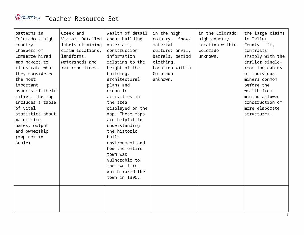
Cripple Creek, 1896 Cripple Creek mining district, “the great gold camp of Colorado,” 1895 Map
1894 Sanborn Fire Insurance Map from Cripple Creek, Teller County, CO
“Colorado, a miner’s blacksmith”
“Colorado, miner’s cabin in winter”
Battle Mountain Mine, Cripple Creek c. 1900
Bird’s eye views of Cripple Creek and Victor bordered by labeled illustrations of the important mines in the district.
Panoramic map of Cripple Creek and Victor.
Series of nine maps of Cripple Creek township in December of 1894.
Photochrome print, color. Taken between 1898 and 1905. Three men, including a blacksmith, posing along a high, narrow footpath.
Photochrome print, color. A miner’s cabin nearly buried in snow. taken between 1898 and 1905.
Photochrome print, color. View of Battle Mountain mine, a major operation just outside of Cripple Creek in Teller County.
Illustration of the economic development and settlement patterns in Colorado’s high country. Chambers of Commerce hired map makers to illustrate what they considered the most important aspects of their cities. The map includes a table of vital statistics about major mine names, output and ownership (map not to scale).
Meticulous panoramic map showing the towns of Cripple Creek and Victor. Detailed labels of mining claim locations, landforms, watersheds and railroad lines.
Commissioned for fire insurance purposes, these maps contain a wealth of detail about building materials, construction information relating to the height of the building, architectural plans and economic activities in the area displayed on the map. These maps are helpful in understanding the historic built environment and how the entire town was vulnerable to the two fires which razed the town in 1896.
Demonstrates the precarious nature of mining and metallurgy in the high country. Shows material culture: anvil, barrels, period clothing. Location within Colorado unknown.
A visceral illustration of the hardships miners endured in the Colorado high country. Location within Colorado unknown.
Elaborate brick and wooden structure above ground on one of the large claims in Teller County. It, contrasts sharply with the earlier single-room log cabins of individual miners common before the wealth from mining allowed construction of more elaborate structures.
2
Teacher Resource Set
http://hdl.loc.gov/loc.gmd/g4314c.pm000600
https://www.loc.gov/item/81691929/
http://hdl.loc.gov/loc.gmd/g4314cm.g009811894
https://www.loc.gov/item/2008678061/
https://www.loc.gov/item/2008678060/
https://www.loc.gov/item/2008678077/
Cripple Creek district, wreckage of Independence Station platform after mining accident, c. 1904
“Five hundred feet underground in a Cripple Creek mine” c. 1890
“A Grassy resort” c. 1899, Miners in cabin around a table
Doc Susie at Cripple Creek home, c. 1893
First house in Cripple Creek, Poverty Gulch
Nomination Form for Cripple Creek Historic District in the National Register of Historic Places
3

Teacher Resource Set
Black and white image of the Independence Rail Station platform wreckage which was the result of violence between the Western Federation of Miners and the Anti-Union Citizen’s Alliance in Teller County.
Black and white photograph of a miner standing next to an ore cart track. Shot five hundred feet underground in an unidentified mine, Cripple Creek, CO.
Six miners gathered around a table in a rough tavern in Grassy, Teller County.
Black and white photo of Susan Anderson and two men standing outside her log home in Cripple Creek, CO. Susan graduated from medical school in 1897 and practiced in Fraser, CO.
An early mining cabin, possibly belonging to first successful Cripple Creek prospector, Robert Womack. Men in their best clothes stand in front of a low cabin with a sod roof, built into the side of the hill.
This 10 page October 15, 1966 nomination form contains a description of the historic district and its significance. Seven photographs of buildings in the historic district are included.
This image could also be used to begin a discussion of how an important event such as this can lend significance to a historic place.
Shows the bleak, dangerous nature of laboring underground. The ragged rocks dwarf the miner, the track is clearly rickety and disappears into an even narrower passage, down which miners may have been working.
Miners had few comforts in the fringe towns outside of Cripple Creek proper, where they spent many nights socializing together at local taverns. Men on small claims were especially isolated.
Women in the West often had more opportunities than those back east: the rougher the location, the more their intellectual talents were employed as business owners, accountants or doctors. Like so many miners, Doc Susie had log-cabin beginnings.
The rags-to-riches story of many miners is illustrated by the increasing sophistication of buildings in Cripple Creek. This photo reflects the humble beginnings of miners in the 1890’s.
The first town of Cripple Creek was razed by fire in 1896. The building materials in the new town were stone and brick.
4

Teacher Resource Set
http://digital.denverlibrary.org/cdm/singleitem/collection/p15330coll22/id/9701/rec/1
http://digital.denverlibrary.org/cdm/singleitem/collection/p15330coll22/id/29349/rec/4
http://digital.denverlibrary.org/cdm/singleitem/collection/p15330coll22/id/5918/rec/1
http://digital.denverlibrary.org/cdm/singleitem/collection/p15330coll22/id/10783/rec/130
http://digital.denverlibrary.org/cdm/singleitem/collection/p15330coll22/id/1192/rec/141
https://npgallery.nps.gov/NRHP/AssetDetail?assetID=1112bbfe-3339-43ca-ba65-200e62a03d69
5

Teacher Resource Set
Midland Terminal Depot, Cripple Creek, CO
Imperial Hotel, Cripple Creek CO
The Old Homestead,Cripple Creek, CO
St Paul’s Catholic Church, Cripple Creek, CO
Teller County Hospital, Cripple Creek, CO
Depot with Midland Terminal observation coach 29, Cripple Creek, CO, February 6, 1949.
When the railroad closed the building was unused some years. It now houses the Cripple Creek-Victor Historic Mining Museum.
Exterior view of restored Imperial Hotel, 123 North Third (3rd) Street, Cripple Creek, CO, c. 1960.
The Imperial Hotel is one of two outstanding hotels in Cripple Creek. It was constructed of brick with a flat top. In recent years, it has been completely renovated on the interior and is now the home of an annual summer production.
Exterior view of the Old Homestead, 353 Myers Avenue, Cripple Creek, CO. The prominent "parlor or sporting" house of the red-light district was in operation for nearly twenty years and later became a residence until reopened in 1950s as a museum.
c. 1969-1970
St. Paul’s Catholic church sits on Third Street on a high hill overlooking the west section of Cripple Creek.
c. 1975
The Teller County Hospital (aka El Paso County Hospital) sits just outside the Cripple Creek city limits on the northwest edge of the town.
The hospital has been recently purchased and is now used as a guest facility for tourists. The interior has been converted for this purpose. The building is now called Hospitality House.
6

Teacher Resource Set
The Midland Terminal Depot was purportedly erected in the early 1890s making it one of the oldest buildings in the town. It is a three-story building with gabled roof. The first level is fashioned of stone while the two upper levels are brick.
In the renovation, all period materials from various hotels in the state were used. The interior is plush in period furnishings and the bedrooms have brass beds and other late 19th, early 20th century furnishings.
A two-story brick building with a flat top roof and painted white, this commercial building has bay window and porch with festoon bar relief, open porch with native rock or stone columns, and glass-paneled single entryway on side.
The church was constructed in the early 20th century. It is one of several other churches in Cripple Creek, none of which are on a grand scale.
The county hospital built in the first decade of the 20th century, is one of the most impressive of the buildings in the district. It was constructed of brick in the Greek Revival Style.
c. 1975
http://digital.denverlibrary.org/cdm/singleitem/collection/p15330coll22/id/67176/rec/1
http://digital.denverlibrary.org/cdm/singleitem/collection/p15330coll22/id/1127/rec/6
http://digital.denverlibrary.org/cdm/singleitem/collection/p15330coll22/id/1391/rec/4
https://npgallery.nps.gov/NRHP/GetAsset/eabb2105-b47d-4c34-b4c6-c5d75c26ff9c/?branding=NRHP Image #5
https://npgallery.nps.gov/NRHP/GetAsset/eabb2105-b47d-4c34-b4c6-c5d75c26ff9c/?branding=NRHP Image #7
7

Teacher Resource Set
Foundations Annotations
Curriculum Connections
History
Economics
Mathematics
Curriculum Standards
CO State History Standard 1: Formulate appropriate hypotheses about United States history based on a variety of historical sources and perspectives. (Eighth Grade)
a. Use and interpret documents and other relevant primary and secondary sources pertaining to United States history from multiple perspectives.
b. Analyze evidence from multiple sources including those with conflicting accounts about specific events in United States history.
CO State Economics Standard 3: Acquire the knowledge and economic reasoning skills to make sound financial decisions. (Seventh Grade)2. The distribution of resources influences economic production and individual choices.
CO State Mathematics Standard 3: Data Analysis, Statistics, and Probability (Eighth Grade)1. Visual displays and summary statistics of two-variable data condense the information in data sets into usable knowledge.
Content and Thinking Objectives
Students will be able to: analyze the material culture in primary source images to reach conclusions about the distribution of Colorado’s mineral wealth in the late
19th Century. use a table of values to identify the most valuable claims and areas for Teller County mining.
Inquiry Questions, Activities and Strategies
8

Teacher Resource Set
Inquiry QuestionsWhy might women on the frontier (like “Doc. Susie”) been given more independence and responsibility than women “back east?”
Inquiry ActivitiesConduct a discussion about the people portrayed in the primary source set. Make a KWL chart based on the images in the primary source set: What do you (KNOW/WANT TO KNOW/LEARNED) about life in high country mining towns in Colorado?
Discuss how artifacts can lead to conclusions about the people who used them. Observe the material culture (clothing, tools, etc.) in each of the primary source images. How are different lifestyles portrayed in these images?
Inquiry Questions, Activities and Strategies (continued)
How do the buildings and structures reflect the different lifestyles found in early 20th century mining towns/cities?
Observe the material culture (clothing, tools, buildings) in each of the primary source images. What does this tell you about the distribution of mineral wealth in Cripple Creek?
Discuss the ways mining affected the landscape of Cripple Creek.
Ask students to use the three maps in the primary source set to locate the most valuable claims in the Cripple Creek mining district. Based on the values in the table, identify particular areas where the richest claims could be found.
9

Teacher Resource Set
Assessment Strategies
Depending upon how one uses the resources and which standards are chosen, assessment can take many forms. For example:
CO History Standard 1.1 (a-b) (Eighth Grade) Make a KWL chart based on the images in the primary source set: What do you (KNOW/WANT TO KNOW/LEARNED) about life in high country mining towns in Colorado? Conduct independent research to fill in the answers to the “WANT” column.
What tools, pieces of clothing, and buildings from the images would you choose for a museum exhibit on the everyday lives of people in Cripple Creek? Draw, design or describe a journey through your exhibit.
Why might women on the frontier (like “Doc. Susie”) be given more independence and responsibility than women “back east?” Discuss in pairs, then write a paragraph using concrete examples from the primary source set.
CO Economics Standard 3.2 (Seventh Grade) Write a paragraph or act out a single-scene play answering the following question: How was the wealth from Cripple Creek gold distributed?
Using details from the primary source set as evidence, write a short essay explaining why miners formed unions to demand better working conditions and increased pay.
CO Mathematics Standard 3.1 (Eighth Grade) Ask students to use the three maps in the primary source set to locate the most valuable claims in the Cripple Creek mining district. Based on the values in the table, identify a particular area where the richest claims could be found.
10

Teacher Resource Set
Other Resources
Web Resources
National Register of Historic Places Homepage: https://www.nps.gov/nr/
National Register of Historic Places – Cripple Creek Historic District: http://focus.nps.gov/GetAsset?assetID=1112bbfe-3339-43ca-ba65-200e62a03d69
Resources from History Colorado: http://www.historycolorado.org/content/teller-county (Teller County) http://www.historycolorado.org/sites/default/files/files/OAHP/crforms_edumat/pdfs/651.pdf (Multiple Property Documentation Form – The
Mining Industry in Colorado)
Resources from the Library of Congress: https://www.loc.gov/search/?fa=location%3ACripple+Creek
Resources from the Denver Public Libraries Digital Collections: http://digital.denverlibrary.org/cdm/search/searchterm/cripple%20creek/field/all/mode/all/conn/and/order/title/ad/asc
The Colorado Encyclopedia Cripple Creek: https://coloradoencyclopedia.org/search/google/cripple%20creek Teller County: https://coloradoencyclopedia.org/article/teller-county
Secondary Sources
Leland Feitz, Cripple Creek! A Quick History of the World’s Greatest Gold Camp, rev. ed. (Colorado Springs, CO: Little London Press, 1967).
Brian Levine, Cripple Creek: City of Influence: An Excursion into the Historic Heart of Colorado’s Greatest Gold Camp (Cripple Creek, CO: Historic Preservation Department, 1994).
William Philpott, The Lessons of Leadville, or, Why the Western Federation of Miners Turned Left (Denver: Colorado Historical Society, 1994).
Rocky Mountain PBS, "Ladies of the Mines” Colorado Experience, January 14, 2016.
11

Teacher Resource Set
Preservation Connection
Cripple Creek is located in Teller County, west of Pikes Peak. A classic Colorado boom-town, Cripple Creek has evolved from a hotbed of mineral extraction into a gaming and tourist destination. The Cripple Creek Historic District was added to the National Register of Historic Places in 1966.
In the years in which other Colorado Mining towns were on the decline, one of the world’s largest gold fields was discovered in 1892 along Cripple Creek. Cripple Creek ranks near the top of all the rich gold strikes of the mining era, for the amount of gold recovered and for the amount of people involved in the boom. It has been estimated that in excess of $400,000,000 in gold has been mined in the Cripple Creek district. At its peak, the population of the district was over 50,000 and was served by three railroads and two trolleys. The Cripple Creek district eventually comprised a number of satellite gold camps. These towns, in many cases, were autonomous entities. In 1899 nearly $20,000,000 was produced from the almost 500 mines. Cripple Creek has lost many of the buildings of the first boom period. There remains, however, a good representation of the buildings constructed during the early 20th century that reflect the character of the town. (From: National Register Nomination Form – Significance)
Cripple Creek Historic District includes buildings that stood throughout the economic boom and bust cycles of Colorado’s mineral economy in the late 19th and early 20th century. As the location of strike showdowns, this site holds an important place in the history of the labor movement in Colorado. Students who visit Cripple Creek can touch into several layers of Colorado history (including architectural, economic, and the science of mining) and the lives of the very rich and poor who experienced its turbulent early days.
Preservation Questions
What can be learned about the past from historic districts such as Cripple Creek?
What are the benefits of preserved sites historically and economically?
How does the Cripple Creek Historic District inform us about the importance of the mining industry at the turn of the 20th century?
12

Teacher Resource Set
Working together to tell the story of our state!
Developers
Sponsors
Partners
13


