Embed Size (px)
Citation preview
THE EXPLORATION FAIRWAY FOR CAMBRIAN MINERALISED COPPER PORPHYRIES IN THE STAVELY ARC OF WESTERN
VICTORIA
David Taylor1, Ross Cayley1, Phil Skladzien1, Robert Duncan1, Jon Woodhead2, Greg Corbett3
1Geological Survey of Victoria, 2University of Melbourne, 3Corbett Geological Services
Keywords. Copper, Moly, Porphyry, Delamerian, Stavely
AbstractMineralised Cu±Mo porphyries were discovered in belts of Cambrian andesite in the Stavely region of western Victoria in the late 1970s. Thick regolith complicates geochemical exploration. Some of the initial aircore exploration drilling failed to penetrate the regolith before refusing so that sampling to define geochemical anomalies was not fully effective. Through to the mid-2000s various companies only completed a small number of follow up diamond drill holes to depths of 100-300 m. This drilling encountered sub-economic grades (typically 0.1-0.3% Cu) mostly in propylitic and phyllic alteration associated with dacitic porphyry dykes intruding up into andesite host rocks. This lack of early success and low gold content, when combined with no historic indicators of viable mineralisation such as artisanal mining and uncertainty over the geological context, meant there was little appetite to persevere. There was no deeper drilling to test for the presence of porphyry bodies as a source for the intruding dykes, or for alteration zonation that might increase to potassic and carry higher metal grades. New data has revived support for early interpretations that the magmatic rocks are part of a Cambrian continental margin magmatic arc – a setting that can host large porphyries. The Stavely region likely represents the moderately well preserved remnants of a volcanic arc developed on the upper crust above a Cambrian subduction zone. This interpretation has focussed new government geoscience studies into this region in an effort to refine and optimise future exploration effort. Recent work by the Geological Survey of Victoria (the Willaura Project) and in collaboration with Geoscience Australia (the Stavely Project) has undertaken more work (including stratigraphic drilling) to better understand the geological evolution of the region and to better characterise the rock types that will be encountered in future exploration. The mineralised porphyry dykes show geochemical similarities to some post-tectonic granites intruded at the end of arc development. This creates a massive expansion in the size of the exploration fairway because a late intrusion age means the porphyries could occur anywhere within the entire Stavely region, rather than being restricted to the few narrow (3-5 km wide) fault-bounded belts of andesitic volcanics as previously thought. The late timing of the porphyries also means they intruded after much of the faulting and tilting of their host rocks so that the alteration/mineralisation systems remain largely upright for easy vectoring.
IntroductionThe Grampians-Stavely (geological) Zone in western Victorian is about 3 hours drive from Melbourne. The Cambrian bedrock comprises multiple fault belts of submarine andesitic volcanics (Mount Stavely Volcanic Complex) separated by panels of folded siliciclastic turbidites (Glenthompson Sandstone) that are intruded by slightly younger post-tectonic granites (informally referred to here as the ‘Bushy Creek Suite’). An unconformably overlying Silurian redbed sequence (Grampians Group) covers part of the region. The Cambrian bedrock forms a flattish landscape of cleared farmland with limited outcrop due to deep pallid weathering (generally 30-100 m thick) and large areas of younger Quaternary basalt flows and sedimentary cover up to 30 m thick. In contrast, the Grampians Group generally forms a mountainous terrain with forested strike ridge topography largely preserved inside National Park (for once it is the barren cover sequence rather than the prospective ground inside the national park!).

Several rounds of exploration from the 1970s until the late 1990s discovered elevated levels of copper and other metals in several prospects in the Cambrian rocks. Some prospects were indicative of volcanic massive sulphides whilst others were interpreted as the distal shallow parts of copper porphyry systems. Low metals grades to the 300m deep limit of exploration, a lack of associated gold, no historic artisanal mining and an unclear plate tectonic setting (magmatic arc or rift volcanics?) provided little incentive for expensive exploration to deeper levels. At the time of this exploration, shallower deposits in well understood geological systems like the Andes or the Philippines provided less risky investment options. Since the mid 2000s however, academic geochemical investigations and government supported deep seismic reflection and broadband magnetotelluric profiles all support the Cambrian plate tectonic setting for the Stavely region as a convergent margin magmatic arc – a setting that can host very large porphyries, as seen in the Andes for example.
The Willaura Project of the Geological Survey of Victoria targeted the region after the new prospectivity boost. This project produced a geological map best outcropping region where structural data and geophysical interpretations help constrain the deformation history of the greater area. Geochemical sampling of mineralised porphyry dykes showed similar geochemistry to large post-tectonic granites that intrude close by. This means that mineralised porphyries could occur anywhere in the Stavely region rather than being confined to the few narrow fault belts of Mount Stavely Volcanics as previously thought. This breakthrough greatly increases the size of the exploration fairway. Collaboration with GeoScience Australia led to the follow on Stavely Project which drilled a number of stratigraphic holes to better understand the geochemistry, age and range of rocks in this expanded exploration fairway and to allow the improved tectonic framework at Willaura to be expanded over the entire fairway.
Regional Geological FrameworkThe Stavely region of western Victoria is an outboard part of the Cambrian Delamerian Fold Belt. This is the oldest and most westerly part of the Phanerozoic Tasman Fold Belt system (the Tasmanides) that now form the continental crust of southeastern Australia (Coney et al., 1990). The Tasmanides originated as oceanic terranes and microcontinental blocks of the paleo-Pacific. These terranes were accreted to the e a s t e r n e d g e o f t h e A u s t r a l i a n Proterozoic continental margin in several successive orogenic cycles, beginning in the Cambrian with the Delamerian Orogeny. In general terms, this accretion was driven by episodic cycles of convergence and extension on the upper plate above an Andean style subduction margin (Collins 2002).
The Cambrian rocks of the Stavely region are generally poorly exposed and mostly covered by a thick pallid regoltih profile. The stratigraphic framework was established by the Geological Survey of Victoria with regional mapping in support of the early exploration (Buckland 1986). The Mount Stavely Volcanic Complex is narrow linear fault belts of basaltic-dacitic lavas, primary breccias and volcaniclastics with associated chert and shale. These are enclosed by wider panels of folded submarine siliciclastic turbidites named the Glenthompson Sandstone. A second round of mapping by GeoScience Australia as part of the National GeoScience Mapping Accord (Stuart-Smith & Black 1999) dated the volcanics as Cambrian (501±9 and 495±5 Ma) and also showed that some of the post-tectonic granites previously assumed to be Devonian (the Bushy Creek Granodiorite) were also in fact Cambrian (489±7 Ma). This post-tectonic granite age is within error of the Mount Stavely Volcanic ages and shows that the submarine volcanics and turbidites had been folded, faulted and converted into crust and then intruded by the granites in only a few million years during the Late Cambrian Delamerian Orogeny. The deformed occurred at low metamorphic grade (prehnite pumpellyite facies). Fission track data shows these rocks have been preserved near the surface since at least the Devonian on very stable crust (Foster & Gleadow 1992)
The earliest academic geochemical investigations of the magmatic rocks (Crawford 1982) revealed a calc-alkaline affinity to allow a geological interpretation as a continental margin magmatic arc. Subsequent comparison with better exposed and similar Cambrian andesites in Tasmania (the Mount Read Volcanics) led to a new model, with the Stavely Volcanics instead interpreted as rift volcanics subsequent to an arc-continent collision as per the Tasmanian plate tectonic model (Crawford & Berry 1992). The original subduction related model for Victoria has now been revived - more recent academic geochemistry with higher resolution trace element analysis plus coincident geochronology shows that magmatism before, during, and after the Delamerian Orogeny all has a subduction zone signature, suggesting a simple west dipping subduction system persisted throughout (Kemp 2003; Foden et al., 2006). The asymmetry of the metamorphic grade in the enclosing geological zones also

support this model: Buchan–style metamorphism in the Glenelg Zone to the west (= back-arc) and Barrovian style metamorphism in the Stawell Zone to the east (= forearc/accretionary wedge) has the 'paired metamorphic belt' geometry indicative of west dipping subduction under the Stavely region in the Cambrian (Miller et al., 2005)
Mineral Exploration BackgroundModern mineral exploration commenced over the Stavely region in the late 1960s with the advent of cheap modern geochemical assaying. WMC conducted stream sediment sampling (-80#, density of 10 per square mile) in 1969-1971. A few weak base metal anomalies were identified but these could not be validated in follow up stream sediment and soil sampling so the ground was dropped.
As the oil shock of the early 1970s crimped demand for oil, many large oil companies diversified into metals. Looking for base metals in now deformed basins was an obvious entry point for companies experienced in basin analysis. Pennzoil Exploration held the Stavely area from 1975-1983 and explored for massive sulphide base metals as might be expected in mafic submarine volcanics associated with chert and shale. Pennzoil’s excellent program pattern drilled 750 shallow aircore holes through the 30-100 m thick regolith along the volcanic belt, collecting fresh samples for assay. Several anomalies containing values greater than 0.1 % copper were defined (Wickliffe, Junction and Thursdays Gossan).
Follow up diamond drilling successfully penetrated 100-200 m down into Wickliffe and Junction, but failed in the regolith at Thursdays Gossan (named after copper stained gossanous float samples – presumably found on a Thursday?). The Wickliffe drilling revealed stringer zones of massive sulphides at sub economic levels (Haydon, 1999) whereas Junction was more indicative of porphyry style mineralisation. Drill logs from Junction document the intersection of volcanic host rocks with “weak chalcocite development” and “intrusive porphyry intersections up to 12 m wide…with strong hydrothermal alteration masking original compositions….plus some weak narrow veining with K-feldspar alteration and disseminated chalcopyrite mineralisation”. Copper assays within the mineralised intervals at 80-130 m depth returned low grades of 500-2000 ppm so the ground was dropped again.
PhD research in the early 1980s documented the calc-alkaline geochemistry of the Mount Stavely Volcanics and suggested they formed as a Cambrian continental margin magmatic arc above a west dipping subduction zone (Crawford 1982). This suggestion is possibly what tempted North/Geopeko to explore in the Stavely region – this company had recently discovered mineralised porphyries in the slightly younger Ordovician andesite belts of the Macquarie Arc at Parkes, NSW, another part of the same Tasmanides. Starting in 1991 (including a JV with CRAE) North/Geopeko conducted significant geophysics programs (gravity and electrical method surveys) and drilled another tranche of just over 1000 shallow aircore holes through the regolith.
Most North/Geopeko effort was put into the previously untested Thursdays Gossan anomaly. Diamond drilling to about 300 m depth revealed the upper portion of a copper porphyry system - the Victor Porphyry - with stocks of dacitic porphyry intruded into propylitic to phyllic altered Stavely Volcanics. A supergene chalcocite blanket lay at the base of oxidation (Rajagopalan 1999; Radojkovic 2003). Their exploration started to extend outside of the volcanic belts by using the geophysics to see through cover. A single diamond hole tested a geochemical anomaly in a late post-tectonic intrusion adjacent to the Stavely Belt. It intersected Cu±Mo mineralisation associated with porphyry dykes (currently held by Navarre Minerals as the Lexington Prospect) that was similar to the style drilled at Thursdays Gossan. It was recognised that all the intersected mineralisation (typically 0.1-0.3% Cu) was likely to be shallow level distal (propylitic) alteration associated with porphyries. There was no follow up for potentially higher grades at depth (hints of potassic alteration were intersected in some of the deepest drilling) because of a lack of associated gold and the need to drill deeper than 300 m. Consequently the ground was dropped in 1997 for the third time, with a cumulative total of some 1850 shallow aircores drilled with about 20 diamond hole follow-ups to generate half-a-dozen prospects (figure 1)
The small company New Challenge Resources was next to take up the Stavely area in 2001 in a JV with Newcrest Mining. A program of 300 m deep diamond holes was completed around the outer annulus of Thursdays Gossan. The results of this drilling remain confidential, due to continuation of this active exploration licence to the current owner of Stavely Minerals. The actual drill core, however, was gifted to the Geological Survey of Victoria by New Challenge Resources and provides material for
whole rock lithogeochemical analysis (rather than just metal assays as done by the exploration companies), U-Pb magmatic zircon dating of the porphyry dykes, plus dating of the mineralisation itself by Re/Os model molybdenite ages. New Challenge Resources eventually transferred the ownership of the lease to BCD Resources in 2009. BCD concentrated on trying to prove up a mineable resource from the shallow supergene chalcocite blanket (Inferred Resource of 10.6 Mt @ 0.45% Cu: BCD Resources Annual Report 2009). BCD Resources also drilled a fault slice of serpentinite within the volcanic belt, looking for potential nickel enrichment adjacent to the porphyry. Lack of sufficient success led BCD Resources to sell the licence to the current owner Stavely Minerals.
Stavely Minerals appreciated that the lack of economic grades in the historic exploration might simply reflect the limited depth of all drilling to date. Until now, only distal shallow levels of generally propylitic mineralisation had been intersected. Evidence of potassic alteration in some of the deeper intersections suggested that perhaps more intense alteration and higher grades (and maybe even larger porphyry bodies rather than just dykes) might occur at depth. Stavely Minerals are currently in the process of exploring down to approximately 600 m in the search for higher grades (Cairns et al., this volume)
Testing new ideas for mineral prospectivityThe revival of a subduction related magmatic arc as the geological setting for the Stavely porphyries is encouraging because such arcs can host large copper porphyry systems (like the Philippines or the Andes). Perhaps the Stavely prospects are worthy of more exploration effort to deeper levels on this basis? Aware of the upside potential for a big mineral system from the geochemistry-led subduction model, the Geological Survey of Victoria collected collaborative deep crustal seismic reflection and coincident broadband magnetotelluric transects across the region. These data image the crust and mantle to allow interpreted geometric frameworks consistent with an ancient west dipping subduction zone under a continental margin (Cayley et al., 2011; Robertson et al., 2015). In the seismic, the transparent lower crust of the Stavely region can be interpreted as a thinned fragment of Proterozoic crust, onto which a more reflective magmatic arc subsequently developed. The MT shows weak conductive pathways emanating up from the mantle, and becoming stronger where they reach the inferred mafic volcanics in the mid crust. Such pathways match model predictions of subduction-fluxed fluids rising from the mantle above a slab, upwards into the crust to cause serpentinisation of mafic rocks.
The Geological Survey of Victoria Willaura Project conducted follow up field mapping and geophysical modelling to better link the exposed surface geology into the crustal framework interpreted in the seismic. Whole rock lithogeochemistry of the mineralised porphyries (from gifted New Challenge Resources drill core) was analysed for the first time, and compared to a previous academic study on the other exposed magmatic rocks in the region (figure 2). This previous study compared the faulted belts of Stavely andesites with the nearby slightly younger and post tectonic Bushy Creek Granite Suite (Whelan et al., 2007). The andesites and the granites all show a characteristic subduction fingerprint, with enrichment in Light Rare Earth Elements except for relative depletion of High Field Strength Elements. The andesites and the granite are related and lie along a mixing/fractionation trend but fall into separate clusters relative to increasing silica content. The new geochemistry shows that the mineralised porphyries plot with the Bushy Creek Granodiorite rather than the Stavely Volcanics (Taylor et al., 2014). If correct, this means the mineralised porphyries could be post tectonic (like the Bushy Creek Granodiorite) and thus intrude anywhere across the entire Stavely Region. This creates a massive prospectivity boost for two reasons. First, this expands the exploration fairway beyond the few narrow fault belts of tilted Stavely Volcanics as previously thought. Second, if the porphyries intruded after the deformation, they will be relatively upright (rather than tilted on their sides) and thus easier to vector downwards towards the deeper potassic alteration zones likely to carry higher metal grades.
Another point of interest from the Willaura Project are a number of basaltic dykes and sills (and possibly lavas) that intrude the Glenthompson Sandstone in the vicinity of the Bushy Creek Granodiorite. Special attention was paid to sampling the dykes because they appeared to be a tightly constrained magmatic pulse between the Stavely Volcanics and the post-tectonic Bushy Creek Granodiorite (the Glenthompson Sandstone hosting the dykes was thought to overlie the volcanics and was in turn intruded by the granite that metamorphoses the dykes). Interestingly the geochemistry of these dykes was completely different to the volcanics and granites and does not have an arc-like signature. Instead their geochemisty is MORB and a close match to basaltic dykes
documented to intrude the Kanmantoo Group in South Australia, where one dyke yielded a 510±2 Ma magmatic zircon age (Liu & Fleming 1990; Chen & Liu 1996). The coarse siliciclastic turbidite Glenthompson Sandstone is also similar to the Kanmantoo Group hosting the dykes in South Australia. This new correlation – implies that the Glenthompson Sandstone is older (or at best coeval) with the Stavely Arc and forms part of the Adelaide Geosyncline rocks rather than a younger post-arc sequence.
A previous exploration case study for Thursdays Gossan (Rajagopalan 1999) has characterised a 1 kilometre diameter geophysical footprint for this porphyry. First is a magnetic anomaly of high and lows (due to magnetite creation and destruction associated with the alteration zones). Second is a gravity low (interpreted as enhanced weathering facilitated by acid sulphate groundwater propagating down the fractures into already altered rocks). Last is an electrically conductive anomaly (interpreted as due to saline groundwater in the deep weathering profile but also because of the sulphides?). The existing regional precompetitive aeromagnetic data has 200-400 m line spacing across the Stavely region so that sampling density is sufficient to reveal many magnetic anomalies with a kilometre-size footprint. Regional gravity and electrical method surveys, however, lack sufficient sampling density to generate corresponding anomalies that might help refine which of the magnetic anomalies justify further investigation. The published case study provides good guidance on future geophysical acquisition priorities for future exploration.
The greater confidence for a continental magmatic arc interpretation has led to the Stavely Project. In collaboration with GeoScience Australia and the Deep Exploration Technologies CRC, a stratigraphic drill program was undertaken to collect more samples of the Cambrian rocks for geochemistry and dating, to help constrain the margins of the new exploration fairway, and to characterise the younger cover sequences (Schofield et al., this volume). At present the newly-expanded Stavely Arc exploration fairway has an exemption on the granting of new exploration licences. Once Stavely Project data has been made publically available, a process of ground release will be enacted to give new explorers the opportunity to use the new work in the delivery of efficient exploration programs.
ConclusionsThe regional seismic reflection and magnetotellurics surveys support geochemistry and geochronology that show the region formed as a magmatic arc above a west-dipping Cambrian subduction zone. The new work of the Willaura and Stavley projects has led to a better understanding of the structural setting and geochemistry of the mineralised porphyries and other rock types likely to be encountered by exploration. Whilst this work has boosted the amount of prospective ground by expanding the exploration fairway across the entire Stavely region, it has also revealed complexity for explorers. The new work shows the most obvious targets to be porphyries that intrude into Cambrian andesites where zones of phyllic overprint caused demagnetisation of the magnetic volcanic host rocks (historic Thursdays Gossan prospect). Less obvious are porphyries intruded into siliciclastic sandstone. Some of these still preserve a prograde potassic cap, and thus form magnetic highs (historic Junction prospect). Others possibilities with less contrast, such as magnetite bearing porphyries in a magnetic volcanic host, or porphyries with magnetite-destructive alteration in the nonmagnetic sedimentary rocks have yet to be discovered (how do you find a polar bear in a snow storm?). The porphyries seem to occur in clusters with a multiphase intrusion history, some mineralised and some barren. Current exploration methodology usually begins with collection of more detailed gravity and electrical method surveys to generate targets for geochemical sampling (which unfortunately will usually require shallow drilling through regolith). This will hopefully create new targets that would need might require moderately deep diamond drilling to properly test for porphyries in this ancient analogue of the modern Andes.
ReferencesBuckland G. 1986. Geology and Mineral Potential of the Mount Stavely Volcanic Complex. Geological
Survey of Victoria Report 80.
Cayley R, Korsch R, Kennett B, Skladzien P, Jones L., Morand V, Gibson G, Rawling T, Betts P. 2011. Results of deep seismic reflection imaging of the eastern Delamerian Orogen, South Australia and western Victoria, Australia. Geological Survey of Victoria Data CD version: 4 March, 2011.

Chen Y, Liu S. 1996. Precise U-Pb zircon dating of a post D2 metadolerite: constraints for rapid tectonic development of the southern Adelaide Fold Belt during the Cambrian. Journal of the Geological Society of London 153, 83-90.
Collins W. 2002. Hot Orogens, tectonic switching and creation of continental crust. Geology 30, 535-538.
Coney P, Edwards A, Hine R, Morrison F, Windrim D. 1990. The regional tectonics of the Tasman orogenic system, eastern Australia. Journal of Structural Geology 12, 519–543.
Crawford A. 1982. The geology, petrology, geochemistry and tectonic implications of Victorian Cambrian greenstones. PhD University of Melbourne.
Crawford A, Berry R. 1992. Tectonic implications of Late Proterozoic-Early Palaeozoic igneous rock associations in western Tasmania. Tectonophysics 214, 37-56.
Foden J, Elburg M, Dougherty-Page J, Burtt A. 2006. The timing and duration of the Delamerian orogeny: Correlation with the Ross Orogen and implications for Gondwana assembly. Journal of Geology 114, 189–210.
Foster D, Gleadow A. 1992. Reactivated tectonic boundaries and implications for the reconstruction of southeastern Australia and northern Victoria Land, Antarctica. Geology 20, 267–270.
Haydon S. 1999. Geophysics and exploration of the volcanic massive sulphide prospect near Wickliffe, western Victoria. In, Geophysical signatures of base metal deposits in Victoria. (Eds) Willocks A, Haydon S, Asten M, Moore D. Geological Survey of Victoria Report 119, 67-80.
Kemp A. 2003. Plutonic boninite-like rocks in an anatectic setting: Tectonic implications for the Delamerian orogen in southeastern Australia. Geology 31, 371–374.
Liu S, Fleming P. 1990. Mafic dykes and their tectonic setting in the southern Adelaide Fold Belt, South Australia. In, Mafic dykes and emplacement mechanisms (Eds) Parker A, Rickwood P, Tucker D. Proceedings of the Second International Dyke Conference, Adelaide. p 401-4013.
Miller J, Phillips D, Wilson, C, Dugdale L. 2005. Evolution of a reworked orogenic zone: the boundary between the Delamerian and Lachlan fold belts. southeastern Australia. Australian Journal of Earth Sciences 52, 921–940.
Radojkovic A. 2003. Thursdays Gossan Porphyry Copper Prospect, western Victoria.. In, Regolith Expressions of Australian Ore Systems (Eds) Butt C, Cornelius M, Scott K, Robertson I. CRC LEME Monograph series.
Rajagopalan S. 1999. Thursdays Gossan Prospect. In, Geophysical signatures of base metal deposits in Victoria. (Eds) Willocks A, Haydon S, Asten M, Moore D. Geological Survey of Victoria Report 119, 129-136.
Robertson K, Taylor D, Thiel S, Heinson G. 2015. Magnetotelluric evidence for serpentinisation in a Cambrian subduction zone beneath the Delamerian Orogen, southeast Australia. Gondwana Research 28, 601–611.
Stuart-Smith P, Black L. 1999. Willaura sheet 7422 Victoria 1:100 000 geological report. Australian Geological Survey Organisation, Record 1999/38.
Taylor D, Cayley R, Skladzien P, Woodhead J, Corbett G. 2014. Geochemistry expands the exploration fairway for the mineralised copper porphyries in western Victoria. Abstracts of the Australian Earth Science Convention, Newcastle, Australia, 2014.
Whelan J, Hergt J, Woodhead J. 2007. Granite-Greenstone connection in Western Victoria: an example from the Bushy Creek Igneous Complex. Australian Journal of Earth Sciences 54, 975-990.

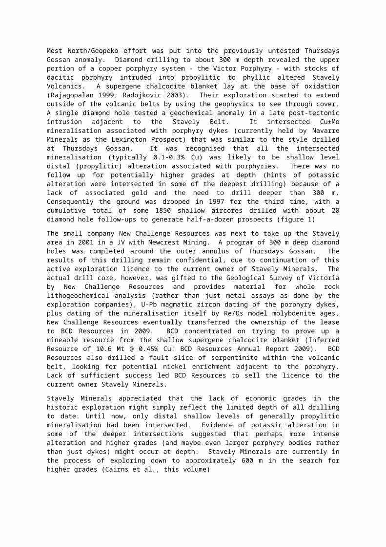
Figure 1. Aeromagnetic background image showing the magnetic volcanic belts of Mount Stavely Volcanics and Bushy Creek intrusions amidst non-magnetic Glenthompson Sandstone (speckles are Quaternary Newer Volcanics lava). The Mount Stavely Belt virtually obscured by the plot of about 1850 shallow aircore holes (drilled in several campaigns) through regolith to generate a handful of copper anomalies tested by deeper drilling. Thursdays Gossan, Junction and Lexington prospects are associated with mineralised dacitic porphyry dykes and propylitic to potassic alteration.

Figure 2. Geochemical comparison of the older, mafic Mount Stavely Volcanics (long dashes) with the younger more felsic Bushy Creek intrusions (short dashes) as adapted from Whelan et al., 1997. All rocks show a subduction fingerprint in the trace elements and lie along a fractionation/mixing trend in two clusters (granitic aplites outlie with higher silica). The geochemistry of the mineralised porphyries from Thursdays Gossan plot as the shaded grey cluster with the Bushy Creek intrusions cluster, rather than the Mount Stavely Volcanics.