Embed Size (px)
Citation preview

1
Archaeological Impact Assessment
For the proposed additional underground and opencast mining, associated infrastructure and processing facilities at Thaba Cronimet Chrome Mine, Limpopo Province.
Prepared For
Worley Parsons Resources and Energy
By
TEL: +27 82 373 8491. E –MAIL [email protected]
VERSION 1.113 July 2015
Revised
22 July 2015
Revised
28 July 2015

2
CLIENT: Worley Parsons Resources and Energy
CONTACT DETAILS: Natalie Kincaid Smith
Tel: +27 11 218 3000
Mob: 0845673842
Fax: +27 11 218 3100
SIGNATURE: ____________________________
LEADING CONSULTANT: Heritage Contracts and Archaeological Consulting CC (HCAC)
CONTACT PERSON: Jaco van der Walt
Heritage Contracts and Archaeological Consulting
Professional Member of the Association of Southern African Professional
Archaeologist (#159)
I, Jaco van der Walt as duly authorised representative of Heritage Contracts and Archaeological Consulting CC, hereby
confirm my independence as a specialist and declare that neither I nor the Heritage Contracts and Archaeological
Consulting CC have any interest, be it business, financial, personal or other, in any proposed activity, application or
appeal in respect of which the client was appointed as Environmental Assessment practitioner, other than fair
remuneration for work performed on this project.
SIGNATURE: ______________________________
3
EXECUTIVE SUMMARY
Site name and location: The Thaba Cronimet Chrome Mine is located in the North Western Bushveld Igneous Complex in the Limpopo Province of South Africa, approximately 18 km north of the town of Northam along the R510 provincial road to Thabazimbi and falls within the Waterberg Magisterial District. The site is located north west of the old Zwartkop Chrome Mine and south east of the Anglo Platinum’s Dishaba and Tumela Mines. The proposed additional opencast and underground mining, associated infrastructure and processing activities will be on portions of the farms Middellaagte 382 KQ, Zwartkop 369 KQ, Elandskuil 378 KQ and Roodedam 368 KQ.
Purpose of the study: Phase 1 Archaeological Impact Assessment to determine the presence of cultural heritage sites and the impact of the proposed project on these resources within the area demarcated for the proposed development.
1:50 000 Topographic Map: 2427 CD and 2427 CB
Environmental Consultant: Worley Parsons Resources and Energy
Developer: Cronimet Chrome Mining SA (Pty) Ltd (“CCMSA”)Heritage Consultant: Heritage Contracts and Archaeological Consulting CC (HCAC).
Contact person: Jaco van der Walt Tel: +27 82 373 8491
E –mail [email protected].
Date of Report: 13 July 2015, Revised 22 July 2015, Revised 28 July 2015
Findings of the Assessment:
CRM surveys, e.g. van Schalkwyk (2004), van der Walt (2009) conducted adjacent to the study area and Huffman (2006) to the north provides a good basis for understanding the local archaeology. From these studies it is clear that evidence for Iron Age activity will most likely be concentrated along water courses and rocky outcrops or hills marked by ceramic clusters or dry stone walling. MSA material is also found in these areas especially at the base of hills and along watercourses. During the archival study documents were found indicating that the farm Zwartkop and Middellaagte on which the proposed project is located was established during the 19th century.
The present report combines the results of an archaeological impact assessment conducted in 2009 together with the results of the current assessment. The combined assessments recorded 5 heritage sites within the proposed expansion areas. Only two of these will be directly impacted by the proposed development: Site 1 and 2 (Iron Age and Stone Age Sites) by the proposed pits and access routes on the farm Zwartkop. Please refer to section 7 of this report for mitigation measures.
If during construction, any archaeological finds are made (e.g. graves, stone tools, skeletal material), the operations must be stopped, and the archaeologist must be contacted for an assessment of the finds.

4
General
Due to the subsurface nature of archaeological material and unmarked graves the possibility of the occurrence of unmarked or informal graves and subsurface finds cannot be excluded. If during construction any possible finds such as stone tool scatters, artefacts or bone and fossil remains are made, the operations must be stopped and a qualified archaeologist must be contacted for an assessment of the find.
Disclaimer: Although all possible care is taken to identify sites of cultural importance during the investigation of study areas, it is always possible that hidden or sub-surface sites could be overlooked during the study. Heritage Contracts and Archaeological Consulting CC and its personnel will not be held liable for such oversights or for costs incurred as a result of such oversights.
Copyright: Copyright of all documents, drawings and records – whether manually or electronically produced – that form part of the submission, and any subsequent reports or project documents, vests in Heritage Contracts and Archaeological Consulting CC. None of the documents, drawings or records may be used or applied in any manner, nor may they be reproduced or transmitted in any form or by any means whatsoever for or to any other person, without the prior written consent of Heritage Contracts and Archaeological Consulting CC. The Client, on acceptance of any submission by Heritage Contracts and Archaeological Consulting CC and on condition that the Client pays to Heritage Contracts and Archaeological Consulting CC the full price for the work as agreed, shall be entitled to use for its own benefit and for the specified project only:
The results of the project; The technology described in any report; Recommendations delivered to the Client.

5
CONTENTS
EXECUTIVE SUMMARY........................................................................................................................ 3GLOSSARY........................................................................................................................................... 71 BACKGROUND INFORMATION.........................................................................................................8
1.1 Terms of Reference................................................................................................................... 91.2. Archaeological Legislation and Best Practice...........................................................................91.2.1. IFC Performance Standards................................................................................................101.3 Description of Study Area........................................................................................................131.3.1 Location Data....................................................................................................................... 131.3.2. Location Map....................................................................................................................... 14
2. APPROACH AND METHODOLOGY................................................................................................162.1 Phase 1 - Desktop Study.........................................................................................................162.1.1 Literature Search.................................................................................................................. 162.1.2 Information Collection...........................................................................................................162.1.3 Consultation......................................................................................................................... 162.1.4 Google Earth and Mapping Survey......................................................................................162.1.5 Genealogical Society of South Africa...................................................................................162.2 Phase 2 - Physical Surveying..................................................................................................162.3. Assumptions and Limitations..................................................................................................16
3. NATURE OF THE DEVELOPMENT.................................................................................................174. HISTORICAL AND ARCHAEOLOGICAL BACKGROUND OF THE STUDY AREA.........................18
4.1 Databases Consulted..............................................................................................................184.2 Background Information for the study Area.............................................................................184.2.1 Archaeological Background..................................................................................................184.3. Historical Background............................................................................................................224.3.1. Maps of the area................................................................................................................. 224.3.2. A Brief History Of The General Study Area.........................................................................264.3.3. Historical Overview Of The Ownership And Development Of The Farms...........................27
5. HERITAGE SITE SIGNIFICANCE AND MITIGATION MEASURES..................................................295.1. Field Rating of Sites...............................................................................................................30
6. BASELINE STUDY-DESCRIPTION OF SITES.................................................................................316.1. Paleontological Sensitivity of the area....................................................................................396.2. Qualitative impact assessment...............................................................................................39
7. RECOMMENDATIONS AND CONCLUSIONS.................................................................................447.1 Reasoned Opinion................................................................................................................... 457.2 Environmental Impact Statement............................................................................................45
8. PROJECT TEAM............................................................................................................................. 459. STATEMENT OF COMPETENCY....................................................................................................4510. REFERENCES............................................................................................................................... 46

6
FIGURESFigure 1: Location map showing the mining right area........................................................................................................14Figure 2: Location of new proposed developments.............................................................................................................15Figure 3: Movement of Bantu speaking farmers (Huffman 2007)........................................................................................20Figure 4: Anglo Platinum Map showing present-day mining activities on Middellaagte 382 KQ, Elandskuil and Zwartkop.
(Anglo Platinum 2011)................................................................................................................................................ 23Figure 5: Map of the farm Middellaagte 382 KQ and the proposed black residential developments thereon. This 1973
image also shows the relation of the farm Middellaagte to the farm Zwartkop. (National Archives of South Africa 1973)........................................................................................................................................................................... 24
Figure 6: 1921 Rustenburg Magisterial Map, indicating the location of Middellaagte (then known as No. 997) Elandskuil, Swartkop and its neighbouring farms. (National Archives of South Africa 1921)........................................................25
Figure 7: Google Image of the study area with track logs of the area covered in black.......................................................32Figure 8: Sites recorded during the survey.......................................................................................................................... 33Figure 9. General Site Conditions on Middellaagte.............................................................................................................34Figure 10. Site conditions on Elandskuil.............................................................................................................................. 34Figure 11. Disturbed area on Zwarkop................................................................................................................................ 34Figure 12. Zwarkop with Mooskop in the background.........................................................................................................34Figure 13: Site 1 & 2 in relation to the proposed activities...................................................................................................35Figure 14: Site 4 in relation to the proposed rail siding........................................................................................................36Figure 15. LIA stone walling at Site 1 and Site 2.................................................................................................................38Figure 16. Range of tools from Site 2.................................................................................................................................. 38Figure 17. Adit on Mooskop................................................................................................................................................. 38Figure 18. Structures at site 4............................................................................................................................................. 38Figure 19. Site 4b, remains of Chromedale.........................................................................................................................39Figure 20. Remains of loading ramp at Site 4b................................................................................................................... 39Figure 21. Ruin at Site 5...................................................................................................................................................... 39Figure 22. Foundations at Site 5......................................................................................................................................... 39

7
ABBREVIATIONSAIA: Archaeological Impact AssessmentASAPA: Association of South African Professional ArchaeologistsBIA: Basic Impact AssessmentCRM: Cultural Resource ManagementECO: Environmental Control OfficerEIA: Environmental Impact Assessment*EIA: Early Iron Age*EIA Practitioner: Environmental Impact Assessment PractitionerEMP: Environmental Management Plan
ESA: Early Stone Age
GPS: Global Positioning SystemHIA: Heritage Impact AssessmentLIA: Late Iron AgeLSA: Late Stone AgeMEC: Member of the Executive CouncilMIA: Middle Iron AgeMPRDA: Mineral and Petroleum Resources Development ActMSA: Middle Stone AgeNEMA: National Environmental Management ActPRHA: Provincial Heritage Resource AgencySADC: Southern African Development CommunitySAHRA: South African Heritage Resources Agency*Although EIA refers to both Environmental Impact Assessment and the Early Iron Age both are internationally accepted abbreviations and must be read and interpreted in the context it is used.
GLOSSARYArchaeological site (remains of human activity over 100 years old)
Early Stone Age (~ 2.6 million to 250 000 years ago)
Middle Stone Age (~ 250 000 to 40-25 000 years ago)
Later Stone Age (~ 40-25 000, to recently, 100 years ago)
The Iron Age (~ AD 400 to 1840)
Historic (~ AD 1840 to 1950)
Historic building (over 60 years old)

8
1 BACKGROUND INFORMATION
Kind of study Archaeological Impact AssessmentType of development MiningDeveloper: Cronimet Chrome Mining SA (Pty) Ltd
(“CCMSA”)
Consultant: Worley Parsons Resources and Energy
The Archaeological Impact Assessment report forms part of the Environmental Impact Assessment for the proposed project for the amendment to the Thaba Cronimet Mine to include additional opencast and underground mining and processing activities. An archaeological impact assessment conducted in 2009 focused on the Western portion of the mining rights area on the farm Zwartkop, Schilpadsnest and Moddergat. Mining activities in these areas have been approved and the current study focuses on the new additional opencast and underground mining activities.
The aim of the study is to identify cultural heritage sites, document, and assess their importance within local, provincial and national context. It serves to assess the impact of the proposed project on non-renewable heritage resources, and to submit appropriate recommendations with regard to the responsible cultural resources management measures that might be required to assist the developer in managing the discovered heritage resources in a responsible manner. It is also conducted to protect, preserve, and develop such resources within the framework provided by the National Heritage Resources Act of 1999 (Act 25 of 1999).
The report outlines the approach and methodology utilized before and during the survey, which includes: Phase 1, a desktop study that includes collection from various published and unpublished sources; Phase 2, the physical surveying of the area on foot and by vehicle; Phase 3, reporting the outcome of the study.
During the survey 5 heritage sites were recorded. General site conditions and features on sites were recorded by means of photographs, GPS locations, and site descriptions. Possible impacts were identified and mitigation measures are proposed in the following report.
This report must also be submitted to the SAHRA for review.
9
1.1 Terms of Reference
Desktop study
Conducting a brief desktop study where information on the area is collected to provide a background setting of the archaeology that can be expected in the area.
Field study
Conduct a field study to: a) systematically survey the proposed project area to locate, identify, record, photograph and describe sites of archaeological, historical or cultural interest; b) record GPS points identified as significant areas; c) determine the levels of significance of the various types of heritage resources recorded in the project area.
Reporting
Report on the identification of anticipated and cumulative impacts the operational units of the proposed project activity may have on the identified heritage resources for all 3 phases of the project; i.e., construction, operation and decommissioning phases. Consider alternatives, should any significant sites be impacted adversely by the proposed project. Ensure that all studies and results comply with Heritage legislation and the code of ethics and guidelines of ASAPA, taking the relevant International Finance Corporation (IFC) guidelines and performance standards into consideration. The Equator Principles (2006), Operational Policy 11.03 (Cultural Property), and Performance Standard 8 (IFC Guidelines 30 April 2006) were applied for this assessment.
To assist the developer in managing the discovered heritage resources in a responsible manner, and to protect, preserve, and develop them within the framework provided by the National Heritage Resources Act of 1999 (Act 25 of 1999).
1.2. Archaeological Legislation and Best Practice
Phase 1, an AIA or a HIA is a pre-requisite for development in South Africa as prescribed by SAHRA and stipulated by legislation. The overall purpose of a heritage specialist input is to:
» Identify any heritage resources, which may be affected;» Assess the nature and degree of significance of such resources;» Establish heritage informants/constraints to guide the development process through establishing thresholds of
impact significance;» Assess the negative and positive impact of the development on these resources;» Make recommendations for the appropriate heritage management of these impacts.
The AIA or HIA, as a specialist sub-section of the EIA, is required under the National Heritage Resources Act NHRA of 1999 (Act 25 of 1999), Section 23(2)(b) of the NEMA and section s.39(3)(b)(iii) of the MPRDA.
The AIA should be submitted, as part of the EIA, BIA or EMP, to the PHRA if established in the province or to SAHRA. SAHRA will be ultimately responsible for the professional evaluation of Phase 1 AIA reports upon which review comments will be issued. 'Best practice' requires Phase 1 AIA reports and additional development information, as per the EIA, BIA/EMP, to be submitted in duplicate to SAHRA after completion of the study. SAHRA accepts Phase 1 AIA reports authored by professional archaeologists, accredited with ASAPA or with a proven ability to do archaeological work.
Minimum accreditation requirements include an Honours degree in archaeology or related discipline and 3 years post-university CRM experience (field supervisor level).
Minimum standards for reports, site documentation and descriptions are set by ASAPA in collaboration with SAHRA. ASAPA is a legal body, based in South Africa, representing professional archaeology in the SADC region. ASAPA is

10
primarily involved in the overseeing of ethical practice and standards regarding the archaeological profession. Membership is based on proposal and secondment by other professional members.
Phase 1 AIAs are primarily concerned with the location and identification of sites situated within a proposed development area. Identified sites should be assessed according to their significance. Relevant conservation or Phase 2 mitigation recommendations should be made. Recommendations are subject to evaluation by SAHRA.
Conservation or Phase 2 mitigation recommendations, as approved by SAHRA, are to be used as guidelines in the developer’s decision making process.
Phase 2 archaeological projects are primarily based on salvage/mitigation excavations preceding development destruction or impact on a site. Phase 2 excavations can only be conducted with a permit, issued by SAHRA to the appointed archaeologist. Permit conditions are prescribed by SAHRA and includes (as minimum requirements) reporting back strategies to SAHRA and deposition of excavated material at an accredited repository.
In the event of a site conservation option being preferred by the developer, a site management plan, prepared by a professional archaeologist and approved by SAHRA, will suffice as minimum requirement.
After mitigation of a site, a destruction permit must be applied for from SAHRA by the client before development may proceed.
Human remains older than 60 years are protected by the National Heritage Resources Act, with reference to Section 36. Graves older than 60 years, but younger than 100 years fall under Section 36 of Act 25 of 1999 (National Heritage Resources Act), as well as the Human Tissues Act (Act 65 of 1983), and are the jurisdiction of SAHRA. The procedure for Consultation Regarding Burial Grounds and Graves (Section 36[5]) of Act 25 of 1999) is applicable to graves older than 60 years that are situated outside a formal cemetery administrated by a local authority. Graves in this age category, located inside a formal cemetery administrated by a local authority, require the same authorisation as set out for graves younger than 60 years, in addition to SAHRA authorisation. If the grave is not situated inside a formal cemetery, but is to be relocated to one, permission from the local authority is required and all regulations, laws and by-laws, set by the cemetery authority, must be adhered to.
Human remains that are less than 60 years old are protected under Section 2(1) of the Removal of Graves and Dead Bodies Ordinance (Ordinance no. 7 of 1925), as well as the Human Tissues Act (Act 65 of 1983), and are the jurisdiction of the National Department of Health and the relevant Provincial Department of Health and must be submitted for final approval to the office of the relevant Provincial Premier. This function is usually delegated to the Provincial MEC for Local Government and Planning; or in some cases, the MEC for Housing and Welfare.
Authorisation for exhumation and reinterment must also be obtained from the relevant local or regional council where the grave is situated, as well as the relevant local or regional council to where the grave is being relocated. All local and regional provisions, laws and by-laws must also be adhered to. To handle and transport human remains, the institution conducting the relocation should be authorised under Section 24 of Act 65 of 1983 (Human Tissues Act).
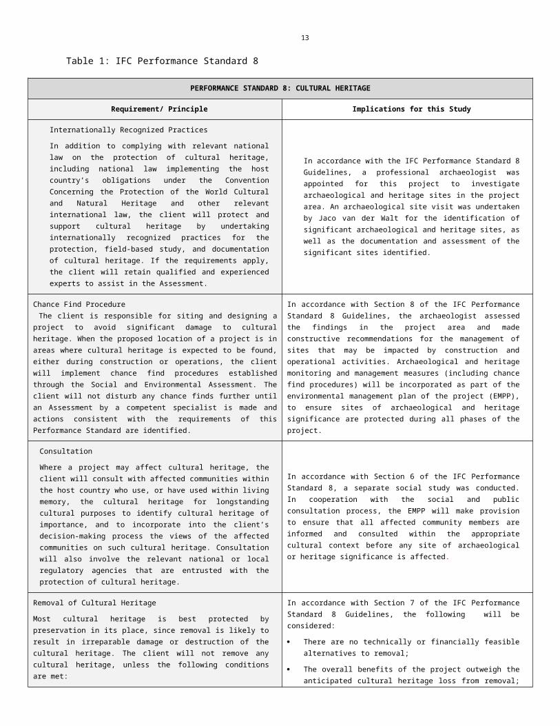
1.2.1. IFC Performance StandardsFor purposes of the heritage component for the Thaba Cronimet Mine Project, the International Finance Corporation’s (IFC) Performance Standard 8 regarding Cultural Heritage is probably the most important guideline. These Standards are part of the Equator Principles established to manage the social and environmental risks (and impacts) of development in its member countries (IFC 2006). The main focus is on the potential impacts associated with project activities during construction, operation, decommissioning and closure. Table 1 outlines performance standards associated with archaeological, heritage and cultural risks related to the project.

11
Table 1: IFC Performance Standard 8
PERFORMANCE STANDARD 8: CULTURAL HERITAGE
Requirement/ Principle Implications for this Study
Internationally Recognized Practices
In addition to complying with relevant national law on the protection of cultural heritage, including national law implementing the host country’s obligations under the Convention Concerning the Protection of the World Cultural and Natural Heritage and other relevant international law, the client will protect and support cultural heritage by undertaking internationally recognized practices for the protection, field-based study, and documentation of cultural heritage. If the requirements apply, the client will retain qualified and experienced experts to assist in the Assessment.
In accordance with the IFC Performance Standard 8 Guidelines, a professional archaeologist was appointed for this project to investigate archaeological and heritage sites in the project area. An archaeological site visit was undertaken by Jaco van der Walt for the identification of significant archaeological and heritage sites, as well as the documentation and assessment of the significant sites identified.
Chance Find Procedure The client is responsible for siting and designing a project to avoid significant damage to cultural heritage. When the proposed location of a project is in areas where cultural heritage is expected to be found, either during construction or operations, the client will implement chance find procedures established through the Social and Environmental Assessment. The client will not disturb any chance finds further until an Assessment by a competent specialist is made and actions consistent with the requirements of this Performance Standard are identified.
In accordance with Section 8 of the IFC Performance Standard 8 Guidelines, the archaeologist assessed the findings in the project area and made constructive recommendations for the management of sites that may be impacted by construction and operational activities. Archaeological and heritage monitoring and management measures (including chance find procedures) will be incorporated as part of the environmental management plan of the project (EMPP), to ensure sites of archaeological and heritage significance are protected during all phases of the project.
Consultation
Where a project may affect cultural heritage, the client will consult with affected communities within the host country who use, or have used within living memory, the cultural heritage for longstanding cultural purposes to identify cultural heritage of importance, and to incorporate into the client’s decision-making process the views of the affected communities on such cultural heritage. Consultation will also involve the relevant national or local regulatory agencies that are entrusted with the protection of cultural heritage.
In accordance with Section 6 of the IFC Performance Standard 8, a separate social study was conducted. In cooperation with the social and public consultation process, the EMPP will make provision to ensure that all affected community members are informed and consulted within the appropriate cultural context before any site of archaeological or heritage significance is affected.
Removal of Cultural Heritage
Most cultural heritage is best protected by preservation in its place, since removal is likely to result in irreparable damage or destruction of the cultural heritage. The client will not remove any cultural heritage, unless the following conditions are met:
There are no technically or financially feasible alternatives to removal
The overall benefits of the project outweigh the anticipated cultural heritage loss from removal
Any removal of cultural heritage is conducted by the best available technique
In accordance with Section 7 of the IFC Performance Standard 8 Guidelines, the following will be considered:
There are no technically or financially feasible alternatives to removal;
The overall benefits of the project outweigh the anticipated cultural heritage loss from removal; and/or
Any removal of cultural heritage material is conducted adhering to heritage legislation and done by scientific standards..

12
Critical cultural heritage consists of(i) the internationally recognized heritage of communities who use, or have used within living memory the cultural heritage for long-standing cultural purposes; and(ii) Legally protected cultural heritage areas, including those proposed by host governments for such designation.
The client will not significantly alter, damage, or remove any critical cultural heritage. In exceptional circumstances , where a project may significantly damage critical cultural heritage, and its damage or loss may endanger the cultural or economic survival of communities within the host country who use the cultural heritage for long-standing cultural purposes , the client will:
(i) meet the requirements of Paragraph 6 above; and
(ii) (ii) conduct a good faith negotiation with and document the informed participation of the affected communities and the successful outcome of the negotiation.
In addition, any other impacts on critical cultural heritage must be appropriately mitigated with the informed participation of the affected communities.
In accordance with Section 8 and 9 of the IFC Performance Standard 8 Guidelines, the client will not significantly alter, damage, or remove any critical cultural heritage or any sites of international value e.g. World Heritage Sites.
Protected Heritage AreasLegally protected cultural heritage areas are important for the protection and conservation of cultural heritage, and additional measures are needed for any projects that would be permitted under the applicable national laws in these areas. In circumstances where a proposed project is located within a legally protected area or a legally defined buffer zone, the client, in addition to the requirements for critical cultural heritage cited above in Paragraph 9, will meet the following requirements :
Comply with defined national or local cultural heritage regulations or the protected area management plans
Consult the protected area sponsors and managers, local communities and other key stakeholders on the proposed project
Implement additional programs, as appropriate, to promote and enhance the conservation aims of the protected area
In accordance with Section 9 of the IFC Performance Standard 8 Guidelines, the EMPP will make provision to ensure that the proposed project area is not located within a legally protected cultural heritage area or a legally defined cultural heritage buffer zone. As part of the environmental impact study, all relevant national and local environmental and social policies, plans and guidelines should be implemented for all development activities associated with the project.
13
1.3 Description of Study Area
1.3.1 Location Data
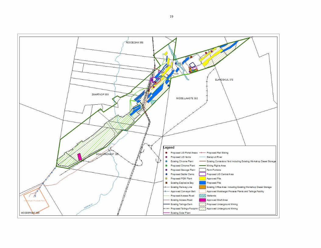
The Thaba Cronimet Chrome Mine is located in the North Western Bushveld Igneous Complex in the Limpopo Province of South Africa, approximately 18 km north of the town of Northam along the R510 provincial road to Thabazimbi and falls within the Waterberg Magisterial District. The site is located north west of the old Zwartkop Chrome Mine and south east of the Anglo Platinum’s Dishaba and Tumela Mines (Figure 1). The proposed additional opencast and underground mining, associated infrastructure and processing activities will be on portions of the farms Middellaagte 382 KQ, Zwartkop 369 KQ, Elandskuil 378 KQ and Roodedam 368 KQ (Figure 2).
The topography of the area is relatively flat characterised by deep turf. The study area falls within a Savannah Biome with the bioregion described by Mucina et al (2006) as the Central Bushveld Bioregion with the vegetation described as Dwaalboom Thornveld. Land use in the general area is characterized by mining and agriculture, dominated by game and cattle farming as well as chrome mines.

14
1.3.2. Location Map
Figure 1: Location map showing the mining right area.

15
Figure 2: Location of new proposed developments.

16
2. APPROACH AND METHODOLOGY
The aim of the study is to cover archaeological databases to compile a background of the archaeology that can be expected in the study area followed by field verification; this was accomplished by means of the following phases.
2.1 Phase 1 - Desktop StudyThe first phase comprised a desktop study scanning existing records for archaeological sites, historical sites, graves, architecture (structures older than 60 years) of the area.
2.1.1 Literature SearchUtilising data for information gathering stored in the archaeological database at Wits and previous CRM reports done in the area. The aim of this is to extract data and information on the area in question.
2.1.2 Information CollectionThe SAHRA report mapping project (Version 1.0) and SAHRIS was consulted to collect data from previously conducted CRM projects in the region to provide a comprehensive account of the history of the study area.
2.1.3 ConsultationA Public consultation process is facilitated by Worley Parsons. The only landowner who expressed heritage concerns was H Braack owner of portion 8 of the farm Zwartkop 369 KQ, who indicated knowledge of archaeological sites on his farm and neighbouring farms. No infrastructure developments are planned on his property as per the current layout.
In addition the survey team consulted several specialists in their respective fields during the 2009 survey. For the Stone Age component Prof K. Kuman was consulted in conjunction with Dr L Pollarolo from the University of the Witwatersrand. Prof. T Huffman, also from the University of the Witwatersrand, gave specialist input with regards to the Iron Age component.
2.1.4 Google Earth and Mapping SurveyGoogle Earth and 1:50 000 maps of the area were utilised to identify possible places where sites of heritage significance might be located.
2.1.5 Genealogical Society of South AfricaThe database of the Genealogical Society was consulted to collect data on any known graves in the area.
2.2 Phase 2 - Physical SurveyingDue to the nature of cultural remains, the majority of which occurs below surface, a field survey of the study area was conducted on foot and by vehicle by a professional archaeologist over a period of 4 days.
2.3. Assumptions and Limitations Due to the fact that most cultural remains may occur below surface, the possibility exists that some features or artefacts may not have been discovered/ recorded during the survey. Low ground visibility of parts of the study area is due to high vegetation and impact from previous mining activities, and the possible occurrence of unmarked graves and other cultural material cannot be excluded. This study did not assess living or intangible heritage.
Only the surface infrastructure footprint area was surveyed as indicated in the location map, and not the entire farm. Although HCAC surveyed the area as thoroughly as possible, it is incumbent upon the developer to stop operations and inform the relevant heritage agency should further cultural remains, such as stone tool scatters, artefacts, bones or fossils, be exposed during the process of development. It is assumed that the sites recorded in 2009 are still intact, but this will have to be verified if development in the area of the sites will proceed prior to mitigation. It is assumed that information for the wider region is applicable. Future changes in layout will require a heritage walk through (of areas not previously covered) and assessment of the impact on known sites. This report must be read in conjunction with the study conducted in 2009.

17
3. NATURE OF THE DEVELOPMENT
The following expansions are proposed, with the locality of the proposed mining and processing facilities indicated on the locality map. The locality of the associated mining and support infrastructure will be determined during the EIA.
Opencast mining Opencast pits with associated gravel access roads; Waste rock residue deposits and top soil and sub soil stockpiles; Settler dams with varying capacities (some exceeding 50 000 m3) for the storage of intercepted ground water and
re-routing to the processing plant for re-use.
Underground mining Additional areas for underground mining, estimated at 75kt/m for a life of 21 years; Two up-cast ventilation shafts consisting of concrete collars built up in selected opencast pits; Twin parallel decline cluster; Two parallel footwall declines; A conveyor decline will be developed as well as a vehicle decline for materials; Ore will be transported to a surface storage stockpile via the decline conveyor belt fed from a series of decline
rock storage silos located at each production level; Waste rock residue deposits and top soil and sub soil stockpiles; Settler dams with varying capacities (some exceeding 50 000m3) for the storage of intercepted ground water and
re-routing to the processing plant for re-use; Underground workshops, stores and battery bays.
Processing facilities A proposed extension to the approved tailings storage facility and associated infrastructure (toe paddock, return
water dam, storm water dam) with a total footprint area of approximately 54 ha. The proposed extension to the tailings storage facility is to be constructed to receive 60 000 t/m of tailings;
Additional processing plant of a capacity of 60 000 m3 of concentrate per month. PGM plant (capacity currently unknown)
Surface support infrastructure Erection of two low energy biological treatment plant with a maximum peak flow of 40 kl/day; New provincial road intersection and bridge in terms of the railway and mine access roads; Railway siding and loading pads; Gate house; Bulk water supply line as well as overhead power supply lines, transformer bay and substation; Surface workshops, including a vehicle wash bay and oil separator; Diesel bay; Change house, lamp room and medical facility; Stores; Mining offices; Designated solid waste management area An explosive off-loading facility of approximately 900m²; Storm water management containment facilities, berms and channels in accordance with the NWA, GN R704.

18
4. HISTORICAL AND ARCHAEOLOGICAL BACKGROUND OF THE STUDY AREA
4.1 Databases Consulted
On the 1.50 000 map sheet 2427 CD several sites are on record for the larger study area at the Wits Archaeological database consisting of historic and LIA (Moloko) sites. Several previous CRM surveys are on record for the larger study area e.g. van Schalkwyk (2004), Huffman (2006) and van der Walt (2009 and 2014).
Mitigation conducted to the south of the study area by the National Cultural History Museum on the farm Elandsfontein 386 KQ, Amandelbult Platinum Mine (van Schalkwyk 2004). This included the survey and mapping of sites in and around the Madeleine Robinson Nature Reserve of the Amandelbult Platinum Mine as part of the proposed extension of the mines operations into the area. From the survey, several stone walled sites conforming to the CCP were identified along the base and between the saddles of the hills. Sites contained central kraals, smaller livestock enclosures, lower grindstones and ceramic scatters. These sites form part of a larger settlement complex dating to the Later Iron Age.
Mitigation of the Rhino Andalusite Mine by Archaeological Resources Management (ARM) (Huffman 2006) resulted in excavation and recording of several Early and Late Iron Age sites to the north of the study area. Specifically, the Happy Rest and Mzonjani facies (EIA) and the Icon and Madikwe facies of the Moloko group (LIA) have been identified. Additionally, ancient mine workings for ochre have been identified.
A Survey for the Cronimet Underground Mine and Process Plant (van der Walt & du Pissanie 2009) recorded 37 sites ranging from historic dwellings, graves, MSA and Iron Age sites. Some of these are located within the current study area.
Genealogical Society and Google Earth Monuments
Neither the Genealogical Society nor the monuments database at Google Earth (Google Earth also include some archaeological sites and historical battlefields) have any recorded sites in the study area.
4.2 Background Information for the study Area
4.2.1 Archaeological Background South Africa has one of the longest archaeological sequences in the world because humanity evolved in the area stretching from the Cape to Ethiopia. Most of this sequence covers the times when our ancestors used stone tools. It is worthwhile, thus, to review the archaeological record for southern Africa and to place in context the known occurrences. The archaeology of the area can be divided into the Stone Age, Iron Age and Historical timeframe. These can be divided as follows:
Stone Age
South Africa has a long and complex Stone Age sequence of more than 2 million years. The broad sequence includes the Later Stone Age, the Middle Stone Age and the Earlier Stone Age. Each of these phases contains sub-phases or industrial complexes, and within these we can expect regional variation regarding characteristics and time ranges. For Cultural Resources Management (CRM) purposes it is often only expected/ possible to identify the presence of the three main phases. Yet sometimes the recognition of cultural groups, affinities or trends in technology and/or subsistence practices, as represented by the sub-phases or industrial complexes, is achievable (Lombard 2011). The three main phases can be divided as follows;
• Later Stone Age; associated with Khoi and San societies and their immediate predecessors. Recently to ~30 thousand years ago
• Middle Stone Age; associated with Homo sapiens and archaic modern humans. 30-300 thousand years ago.
19
• Earlier Stone Age; associated with early Homo groups such as Homo habilis and Homo erectus. 400 000-> 2 million years ago.
Early Stone Age:
The Early Stone Age in southern Africa is defined by the Oldowan complex, primarily found at the sites Sterkfontein, Swartkrans and Kroomdraai, situated within the Cradle of Humankind, just outside Johannesburg (Kuman, 1998). Within this complex, tools are more casual and expediently made and tools consist of rough cobble cores and simple flakes. The flakes were used for such activities as skinning and cutting meat from scavenged animals. This industry is unlikely to occur in the study area.
The second complex is that of the more common Acheulean, defined by large handaxes and cleavers produced by hominids at about 1.4 million years ago (Deacon & Deacon, 1999). Among other things these Acheulian tools were probably used to butcher large animals such as elephants, rhinoceros and hippopotamus that had died from natural causes. Acheulian artefacts are usually found near the raw material from where they were quarried, at butchering sites, or as isolated finds. No Acheulian sites are on record near the project area, but isolated finds are possible. However, isolated finds have little value. Therefore, the project is unlikely to disturb a significant site. The presence and significance of finds will be determined by a field investigation.
Middle Stone Age:
During the Middle Stone Age, significant changes start to occur in the evolution of the human species. These changes manifest themselves in the complexity of the stone tools created, as seen in the diversity of tools, the standardisation of these tools over a wide spread area, the introduction of blade technology, and the development of ornaments and art. What these concepts ultimately attest to is an increase or development of abstract thinking. By the beginning of the Middle Stone Age (MSA), tool kits included prepared cores, parallel-sided blades and triangular points hafted to make spears (Volman, 1984). MSA people had become accomplished hunters by this time, especially of large grazing animals such as wildebeest, hartebeest and eland.
These hunters are classified as early humans, but by 100,000 years ago, they were anatomically fully modern. The oldest evidence for this change has been found in South Africa, and it is an important point in debates about the origins of modern humanity. In particular, the degree to which behaviour was fully modern is still a matter of debate. The repeated use of caves indicates that MSA people had developed the concept of a home base and that they could make fire. These were two important steps in cultural evolution (Deacon & Deacon, 1999). Accordingly, if there are caves in the study area, they may be sites of archaeological significance.
MSA artefacts are common throughout southern Africa, but unless they occur in undisturbed deposits, they have little significance. Some MSA sites are on record close to the study area.
Later Stone Age:
By the Late Stone Age, human beings are anatomically and culturally modern. Tools associated with this time period are specialised, and commonly associated with hunter-gatherer groups. It is also within this period that contacts with migrating groups occur throughout southern Africa. Initial contact was between hunter-gatherer groups and expanding Bantu farming societies, and secondly with the arrival of colonist along the coast.
San rock art has a well-earned reputation for aesthetic appeal and symbolic complexity (Lewis-Williams, 1981). Several rock art sites are on record to the north and east of the general project area.
In addition to art, LSA sites contain diagnostic artefacts, including microlithic scrapers and segments made from very fine-grained rock (Wadley, 1987). Spear hunting probably continued, but LSA people also hunted small game with bows and poisoned arrows. Sites in the open are usually poorly preserved and therefore have less value than sites in caves or rock shelters. If there are rock shelters or caves in the study area, they may contain LSA sites of significance.
The closest Stone Age terrain to the study area is located a small distance to the west thereof. This Early Stone Age terrain is situated near the Rooiberg Hill and the Blaauwberg Stone Age Terrain. (Bergh 1999: 4)

20

21
Iron Age (general)
The Iron Age as a whole represents the spread of Bantu speaking people and includes both the pre-Historic and Historic periods. It can be divided into three distinct periods:
The Early Iron Age: Most of the first millennium AD.
The Middle Iron Age: 10th to 13th centuries AD
The Late Iron Age: 14th century to colonial period.
The Iron Age is characterised by the ability of these early people to manipulate and work Iron ore into implements that assisted them in creating a favourable environment to make a better living.
Figure 3: Movement of Bantu speaking farmers (Huffman 2007)
22
Early Iron Age
Early in the first millennium AD, there seem to be a significant change in the archaeological record of the greater part of eastern and southern Africa lying between the equator and Natal. This change is marked by the appearance of a characteristic ceramic style that belongs to a single stylistic tradition. These Early Iron Age people practised a mixed farming economy and had the technology to work metals like iron and copper. A meaningful interpretation of the Early Iron Age has been hampered by the uneven distribution of research conducted so far; this can be partly attributed to the poor preservation of these early sites.
Sites belonging to the EIA consisting of Happy Rest and Mzonjani facies have been recorded to the north of the project area. Happy Rest and Mzonjani pottery form part of two traditions (Kalundu and Urewe) that represent the spread of mixed farmers into southern Africa during the Early Iron Age (See Figure 3). This find is important as it provides evidence for early interaction between these groups. Later, by the 8th and 9th centuries, the two merged to form a new facies, Doornkop.
Middle Iron Age
No sites dating to this period are on record close to the study area.
Late Iron Age
For the area in question the history and archaeology of the Sotho Tswana are of interest. The ceramic sequence for the Sotho Tswana is referred to as Moloko and consists of different facies with origins in either the Icon facies or a different branch associated with Nguni speakers. Several sites belonging to the Madikwe and Olifantspoort facies (from Icon) have been recorded close to the project area. These sites date to between AD 1500 and 1700 and predate stone walling ascribed to Sotho-Tswana speakers. Sotho Tswana stonewalled sites with Uitkomst pottery have been found close to the study area and dates to the seventeenth to nineteenth centuries. Stone walled sites belonging to the LIA have also been identified next to the study area but so far have not been linked to a cultural group.
Late Iron Age peoples were attracted to the area because of the relatively fertile soils around the hills and valleys, and because of the iron ore and red ochre. Mining techniques associated with the ancient mine workings are the same as those found in the Rooiberg area some 30km from Thabazimbi (Huffman 2006). Three groups are found in the Rooiberg area, specifically Madikwe, Melora and Rooiberg groups. Strategraphically, the relationship between Madikwe and Rooiberg is evident where the Madikwe site 20/85 lies underneath the Rooiberg site 11/85, suggesting that Rooiberg is the more recent (Mason 1986). Ceramic evidence suggests then that at one time Sotho-Tswana people were mining at Rooiberg. The ceramic evidence from the Rhino Andalusite Mine shows that the Sotho-Tswana people living there were directly related to the miners at Rooiberg: both belonged to the Western Sotho-Tswana cluster. Therefore the relationship, between the ochre mine and Madikwe settlements, is of importance. Associated with the Madikwe settlements, in addition to the ochre mine is the several maize grindstones found.
Trade connections for ochre and tin have a bearing on the presence of maize. Trade networks spanned a wide area, up to the Zimbabwe culture area in the north, and as far as Maputo in the east before the arrival of the Dutch (Friede & Steel 1976). Maize came to Maputo sometime after the early 16th century through Portuguese trade with the New World. The grindstones found at the site CB14 in the Rhino Andalusite Mine indicate that maize was grown in the Thabazimbi area during the 17th century (Huffman 2006). If one accepts the grindstone as diagnostic, then maize was cultivated some 150 years earlier than in Kwazulu-Natal.
Evidence for Iron Age activity will most likely be concentrated along water courses and rocky outcrops marked by ceramic clusters or dry stone walling.

23
4.3. Historical Background
The historic timeframe sometimes intermingles with the later parts of the Stone and Iron Age, and can loosely be regarded as times when written and oral accounts of incidents became available. An archival study on the farms in question revealed the following.
4.3.1. Maps of the area
Since the mid 1800’s up until the present, South Africa had been classified into various different districts. In 1848, the present-day Middellaagte 382 KQ and other farms in the study area would have been located in the Soutpansberg District. Since 1851, however, the farm area formed part of the Rustenburg District. This remained the case up until 1977, when the country was subdivided into various smaller Magisterial Districts. The study area fell under the authority of the Thabazimbi Magisterial District. This still remains the case today (Bergh 1999: 17-27). The study area has also been subjected to mining activities that would have impacted on surface indications of heritage sites (Figure 4).

24
Figure 4: Anglo Platinum Map showing present-day mining activities on Middellaagte 382 KQ, Elandskuil and Zwartkop. (Anglo Platinum 2011)

25
Figure 5: Map of the farm Middellaagte 382 KQ and the proposed black residential developments thereon. This 1973 image also shows the relation of the farm Middellaagte to the farm Zwartkop. (National Archives of South Africa 1973)

26
Figure 6: 1921 Rustenburg Magisterial Map, indicating the location of Middellaagte (then known as No. 997) Elandskuil, Swartkop and its neighbouring farms. (National Archives of South Africa 1921)

27
4.3.2. A Brief History Of The General Study Area
J. S. Bergh’s historical atlas of the four northern provinces of South Africa is a very useful source for the writing of local and regional histories. It seems that, by the start of the nineteenth century, the predominant black community living in the Amandelbult area was the Kgatla. (Bergh 1999: 11) In a few decades, however, the sociographic nature of the then Transvaal province would change forever. The Difaqane (Sotho), or Mfekane (“the crushing” in Nguni) was a time of bloody upheavals in Natal and on the Highveld, which occurred around the early 1820’s until the late 1830’s. (Bergh 1999: 109-115) It came about in response to heightened competition for land and trade, and caused population groups like gun-carrying Griquas and Shaka’s Zulus to attack other tribes. (Bergh 1999: 14; 116-119) Whereas several tribes were scattered and displaced from their original residences, the Kgatla still inhabit this part of the country today. Though especially the Ndebele of Mzilikazi troubled this tribe during the Difaqane, these people mostly returned to their original settlements after this time of upheaval. The areas settled by the Kgatla included the land to the north of Pretoria in the area of the Crocodile-, Pienaars- and Apies Rivers; the Magaliesberg Mountain; the area of the present-day Brits, Rustenburg, Warmbad (Bela Bela), Nylstroom (Modimolle); as well as the Pilanesberg and the Waterberg areas. The specific Kgatla community that lived in the Rustenburg district, and possibly in the Amandelbult area, was the Modimosana ba Maake-Kwena under Kgaswane and the Modimosana ba Matlhaku-Kwena of Madintsi. (Bergh 1999: 106)
During the time of the Difaqane, a northwards migration of white settlers from the Cape was also taking place. Some travellers, missionaries and adventurers had gone on expeditions to the northern areas in South Africa – some as early as in the 1720’s. A year after the second British occupation of the Cape in 1806, a number of white travellers with official authorization ventured northward with the intention of reaching Delagoa Bay by land. This expedition was led by Dr Andrew Cowan and Lieutenant Donovan. These travellers passed close by the area where the study area is located in 1808. The entire party however disappeared, and it is believed that they either perished from fever or at the hand of black tribes. (Bergh 1999: 12, 117) From the 1830’s onward, a number of other adventurers also passed through or close by the Amandelbult area. These were Hume (1930), Harris (1836) and Livingstone (1847). (Bergh 1999: 13) David Hume, a Scottish trader, advanced to the north of the Limpopo into the inland. It is possible that he was the first European person to travel this farm north in South Africa. (Bergh 1999: 120) The flamboyant British officer, Captain William Cornwallis Harris, left Port Elizabeth in 1836 on a hunting expedition to the northern provinces. He was accompanied by a friend, William Richardson, and a number of servants. These travellers managed to meet the Ndebele chief, Mzilikazi, during their travels. Harris is well known for his descriptions and sketches of wild animals that he saw during his journey. David Livingstone is very well known, and he did not only travel in South Africa, but also deep into mid Africa. Livingstone arrived in Kuruman in 1841 as a missionary of the London Mission Society. In the following years he undertook various travels in the northern provinces, establishing mission stations where he went. (Bergh 1999: 122-123)
By the late 1820’s, a mass-movement of Dutch speaking people in the Cape Colony started advancing into the northern areas. This was due to feelings of mounting dissatisfaction caused by economical and other circumstances in the Cape. This movement later became known as the Great Trek. This migration resulted in a massive increase in the extent of that proportion of modern South Africa dominated by people of European descent. (Ross 2002: 39) These Dutch settlers allocated farms in the Amandelbult area during the 1940s. (Bergh 1999: 15) It therefore is possible that the farms may date back to the middle of the 19th century (Bergh 1999: 15). The district of Waterberg was established in 1866 (Bergh 1999: 139). This indicates that there must have been enough people to make the establishment of a district a viable option.
As can be expected, the movement of whites into the northern provinces would have a significant impact on the black people who populated the land. This was also the case in Limpopo, the then Northern Transvaal area. By 1860, the population of whites in the central Transvaal was already very dense and the administrative machinery of their leaders was firmly in place. Many of the policies that would later be entrenched as legislation during the period of apartheid had already been developed. (Bergh 1999: 170)

28
Much can be said about the systematic oppression of black people in South Africa. In 1904 about a half of the black population in the Transvaal was living on private land, owned by whites or companies. According to the Squatters’ Law of 1895, no more than five families of “natives” could live on any farm or divided portion of a farm, without special permission of the Government in the Transvaal. (Massie 1905: 97) In Bergh’s source, one can see a map indicating the areas where blacks had settled by 1904. It is interesting that there were a number of private farms owned by blacks in the vicinity of Amandelbult by 1904. (Bergh 1999: 41) The 1913 and 1936 Acts concerning the establishment of black “homelands” however delimited areas of land that were located to the southeast and southwest of the Amandelbult area. This land, including other portions of land, collectively became known as Bophuthatswana. (Bergh 1999: 42-43)
Black and white relations were however at times also interdependent in nature. After the Great Trek, when white farmers had settled at various areas in the northern provinces, wealthier farmers were often willing to lodge needy white families on their property in exchange for odd jobs and commando service. This bywoner often arrived with a family and a few cows. He would till the soil and pay a minimal rent to the farmer from the crops he grew. The farmer did not consider him a laborer, but mostly kept black workers for hard labour on the farm. The Anglo-Boer War was the greatest conflict that had taken place in South Africa up to date. Though the Rustenburg district was affected by this war, which took place between 1899 and 1902, there were no well-known skirmishes took place in the area in which Amandelbult is located today. (Bergh 1999: 54) After the Anglo-Boer War, many families were left destitute. Post war years of severe droughts and locust plagues did not ameliorate this state of affairs. All of these factors resulted in what became known as the ‘poor white problem’. On the advent of commercial farming in South Africa, white landowners soon found bywoners to be a financial burden, and many were evicted from farms. In many cases, wealthier landlords found it far more profitable to rent their land to blacks than to bywoners. This enabled them to create reservoirs of black labour (for which mine recruiting agencies were prepared to pay handsome commissions), while it was also possible to draw more rent from their black tenants. This practice was outlawed by the 1913 Natives Land Act, which forbade more than five black families from living on white farms as peasant squatters. (Readers Digest 1992: 329-332)
The town of Rustenburg, after which the district in which Amandelbult is located would be named in 1851, came into being as a “church town”, as many other towns in South Africa had. By the late 1940s, Commandant Gert Kruger’s farm, called Hekport, became a central point for church services. Large numbers of Voortrekker wagons would congregate on the property to attend this “temporary church”. Two delegates were sent to the area by the Volksraad of the Transvaal to serve as deacons and to decide on the layout of the “church farm”. Very interestingly, one of these delegates, Casper Johannes Hendrik Kruger, was the father of the future president of the Transvaal, Paul Kruger. A village developed in the area, and became known as Rustenburg. To this day, it is not known where the name originated, though there are many theories on the subject. The town was first officially referred to as Rustenburg in 1951. (Rosenthal 1979: 18-25)
4.3.3. Historical Overview Of The Ownership And Development Of The Farms
For this section, it was necessary to do an archival search at the National Archives of South Africa. Though the information in these document only give one glimpses of what transpired, and it was not possible to obtain a full title deed record for the properties, one can nonetheless start to form an understanding of the history of the area by the information obtained for the farm Middellaagte 382 KQ.
In March 1904, the Inspector of Schools in the Rustenburg area recommended that a school building would be constructed on the farm Zandfontein No. 256, where a very dilapidated temporary farm school tent stood at the time. He believed that a permanent building would increase the attendance at the school. A school was built shortly thereafter, but by 1922 it was proposed that the institute would be closed. This was due to the fact that a long drought had caused many farmers to vacate the area and to move to areas where water was available. The school however remained open up until the early 1930s, when it was proposed that the name would be changed to the Middellaagte School, since this farm was located close to the institution and this name would avoid confusion. The area was generally known as Middellaagte. (National Archives of South Africa 1904-1931)
On 21 August 1933, a Crown Grant for the farm “Middellaagte” No 997, in the Rustenburg District, was issued to one Jakobus Stephanus Viljoen. All rights to minerals, mineral oils, mineral products, metals and precious stones were reserved to the Crown. (National Archives of South Africa 1933)

29
In March 1935, it was reported that the Government school on Middellaagte was in a good state of reparation, though its outside appearance had become unattractive. The institution was however kept clean and neat. The report on academic progress at the school was generally positive, and it is noted that 20 new desks had to replace the 15 old ones. Miss M. A. Smit and the Principal, Mr. J. C. de Villiers, were the only two teachers at the school. 39 students attended the institution at that time. In March 1940, the Inspector of Education recommended that the Middellaagte School would be closed, since children could use the bus service to attend a more centralized school. (National Archives of South Africa 1935-1944)
By the 1930’s, the international economic depression was also affecting the Transvaal. This gave rise to the poor white problem, and caused many families to become bywoners on the land of wealthier landowners. In 1937, one Nicolaas Johannes Le Roux, a 60 year old man, applied to become a bywoner on the farm Middellaagte No. 997 for a period of 5 years. He had eight children, of which most were adults. Le Roux was very poor, as his previous property had been repossessed. He owned 10 donkeys, but no cattle. (National Archives of South Africa 1937) A 59 year old man, Johannes Niklaas van der Bergh, applied to settle on the farm Zandfontein 256 in 1938. He had been living on the farm Middellaagte for the previous two years as a bywoner. He was the owner of 10 oxen, but had no money. The owner of Zandfontein was his son. (National Archives of South Africa 1938)
In July 1973, the Chief Bantu Affairs Commissioner approved that Rustenburg Platinum Mines Limited could construct “Bantu housing” and recreational facilities on the western section of the Amandelbult Mine, namely the property Elandsfontein 386 KQ. At that time, no quarters had been built on the property. The 200 black workers that were at that stage employed on the mine were housed at the Union Section on Swartklip. A compound would be constructed to provide housing for 4000 labourers. (National Archives of South Africa 1973).
In September 1974, Rustenburg Platinum Mines Limited again applied to the Director of Local Government to allow the company to build housing for key white personnel. The new mine at which the residences would be built, incorporated the farms Amandelbult 383 KQ and Middellaagte 382 KQ, among others. The housing would, however, not be erected on Middellaagte, but rather on the neighbouring farms Schildpadnest 385 and Elandsfontein 386 KQ. Some houses had already been erected on these farms at the time. In July 1978, the mining company received permission from the Director of local government to start the construction of the township, subject to a number of conditions. No more than 110 dwelling units could be erected, and these would be occupied solely by persons in the bona fide employ of the mine, as well as their families. The township development would take place on the farms Schildpadnest 385 and Elandsfontein 386 KQ. (National Archives of South Africa 1974-1980)
Zwartkop
A number of 1046 documents relating to Zwartkop were found in the National Archives Depot in Pretoria. Most of these documents refer to other farms with the same name as those investigated.
No applicable information could be obtained from the Deeds Office (Deeds Office 1367526). The oldest date obtained refers to the estate of the late C J Becker. It indicates that he was the owner of this farm until his death in 1893 (NAD, TAB, SS000, R11460 /93). Two other documents refer to amounts that are owed for taxes on the farm. These documents are both dated to 1894 (NAD, TAB, SP 41, SPR 111/94; NAD, TAB, SP 42, SPR 111/94). These documents give proof that the farm was established during the 19th century, but unfortunately not much more can be learned from them.
At some stage the farm was leased to a certain LMM Charlie, but unfortunately no date is given (NAD, SAB, URU 1138, 1723). It seems as if the farm was already used for mining (or at least prospecting) during 1937 (NAD, SAB, LDE 2147, 104/1).

30
5. HERITAGE SITE SIGNIFICANCE AND MITIGATION MEASURES
The presence and distribution of heritage resources define a ‘heritage landscape’. In this landscape, every site is relevant. In addition, because heritage resources are non-renewable, heritage surveys need to investigate an entire project area, or a representative sample, depending on the nature of the project. In the case of the proposed development the local extent of its impact necessitates a representative sample and only the footprint of the areas demarcated for development were surveyed. In all initial investigations, however, the specialists are responsible only for the identification of resources visible on the surface.
This section describes the evaluation criteria used for determining the significance of archaeological and heritage sites. The following criteria were used to establish site significance:
» The unique nature of a site;» The integrity of the archaeological/cultural heritage deposits;» The wider historic, archaeological and geographic context of the site;» The location of the site in relation to other similar sites or features;» The depth of the archaeological deposit (when it can be determined/is known);» The preservation condition of the sites;» Potential to answer present research questions.
Furthermore, The National Heritage Resources Act (Act No 25 of 1999, Sec 3) distinguishes nine criteria for places and objects to qualify as ‘part of the national estate’ if they have cultural significance or other special value. These criteria are:
» Its importance in/to the community, or pattern of South Africa’s history; » Its possession of uncommon, rare or endangered aspects of South Africa’s natural or cultural heritage;» Its potential to yield information that will contribute to an understanding of South Africa’s natural or cultural heritage;» Its importance in demonstrating the principal characteristics of a particular class of South Africa’s natural or
cultural places or objects;» Its importance in exhibiting particular aesthetic characteristics valued by a community or cultural group;» Its importance in demonstrating a high degree of creative or technical achievement at a particular period;» Its strong or special association with a particular community or cultural group for social, cultural or spiritual
reasons;» Its strong or special association with the life or work of a person, group or organisation of importance in the history
of South Africa;» Sites of significance relating to the history of slavery in South Africa.

31
5.1. Field Rating of Sites
Site significance classification standards prescribed by SAHRA (2006), and acknowledged by ASAPA for the SADC region, were used for the purpose of this report. The recommendations for each site should be read in conjunction with section 7 of this report.
FIELD RATING GRADE SIGNIFICANCE RECOMMENDED MITIGATION
National Significance (NS)
Grade 1 - Conservation; national site nomination
Provincial Significance (PS)
Grade 2 - Conservation; provincial site nomination
Local Significance (LS)
Grade 3A High significance Conservation; mitigation not advised
Local Significance (LS)
Grade 3B High significance Mitigation (part of site should be retained)
Generally Protected A (GP.A)
- High/medium significance
Mitigation before destruction
Generally Protected B (GP.B)
- Medium significance Recording before destruction
Generally Protected C (GP.C)
- Low significance Destruction

32
6. BASELINE STUDY-DESCRIPTION OF SITES
CRM surveys, e.g. van Schalkwyk (2004), van der Walt (2009 & 2014) conducted adjacent to the current area under investigation and Huffman (2006) to the north provides a good basis for understanding the local archaeology. From these studies it is clear that evidence for Iron Age activity will most likely be concentrated along water courses and rocky outcrops or hills marked by ceramic clusters or dry stone walling, MSA material is also found in these areas.
Topographically, the study areas on Middellaagte and Elandskuil consist of generally flat open veld with stretches of more dense vegetation (Dichrostachys shrubs) characterised by deep turf (Figure 9 -11). No major landscape features occur on these farms apart from a wetland on Middellaagte and the area is void of raw material suitable for making Stone Tools or building material for Later Iron Age stone walled settlements. During the survey no archaeological sites were recorded on these farms apart from some isolated highly weathered MSA flakes. These weathered artefacts show signs of being rolled and are not in-situ and are of low significance.
The exception to this pattern is found in the western portion of the study area on the farm Zwartkop where a hill called Mooskop occur (Figure 12). Iron Age stone walling and MSA material is found around the hill (van der Walt 2009) although previous mining activities impacted on the sites. Around the study area Iron Age settlements are concentrated along the Bierspruit and rocky outcrops or hills marked by ceramic clusters or dry stone walling. MSA material is also found in these areas especially at the base of hills and along watercourses (van Schalkwyk 2004 and van der Walt 2009).
The field survey did not cover the entire farms in the study area but focussed on the new proposed activity areas (Figure 2 and 8). During the survey 4 sites was recorded (Figure 9) and is briefly described below.
Table 2: Recorded sites with co-ordinates
Site Number Type Site Co-ordinatesSite 1 Iron Age 24° 46' 40.7027" S, 27° 18' 53.7587" ESite 2 Iron Age /Stone Age 24° 46' 24.0528" S, 27° 18' 50.9651" ESite 3 Mine Adits 24° 46' 33.9434" S, 27° 18' 41.5354" ESite 4Site 4b Historic
24° 46' 02.8453" S, 27° 19' 27.6457" E24° 45' 53.4739" S, 27° 19' 30.1002" E
Site 5 Ruin 24° 45' 12.7475" S, 27° 20' 43.9549"E

33
Figure 7: Google Image of the study area with track logs of the area covered in black

34
Figure 8: Sites recorded during the survey.
35
Figure 9. General Site Conditions on Middellaagte. Figure 10. Site conditions on Elandskuil.
Figure 11. Disturbed area on Zwarkop. Figure 12. Zwarkop with Mooskop in the background.
36
Site 1
This site was recorded in 2009 and is located on the farm Zwartkop to the south east of Mooskop. The site consists of an LIA overgrown stone walled settlement (Figure 15) over an area of approximately 10ha. Previous mine activities impacted negatively on the site destroying a large part of the settlement complex. Cultural material consists of undecorated ceramics, site layout conforms to the CCP but finer layout features are obscured by high vegetation and the fact that large parts of the settlement are destroyed by mining activity. The site will be directly impacted on by the proposed access roads, pits and dumps on Zwarkop (Figure 13).
FIELD RATING SIGNIFICANCE
Generally Protected A (GP.A) Medium Significance
Site 2
This is a multicomponent site (MSA and LIA), also located on the farm Zwartkop to the north of Mooskop. The LIA stone walled settlement is highly overgrown but fairly well preserved and also conforms to the CCP. This site was recorded in 2009.
A cluster of MSA artefacts (4 artefacts per 2m²) scattered mostly on the northern side of Mooskop forms part of this site. Raw material is abundant in this area consisting of Quartzite, Chert, Banded Iron Stone and Rhyolite. Artefacts consist of diagnostic MSA tools (Figure 16) and includes amongst other prepared cores and tools with facets on the striking platform. The tools are well preserved and do not show much weathering and contain clear diagnostic features. The site will be directly impacted on by the proposed access roads, and indirectly by the proposed pits and dumps on Zwarkop (Figure 13).
FIELD RATING SIGNIFICANCE
Generally Protected A (GP.A) Medium Significance
Figure 13: Site 1 & 2 in relation to the proposed activities.

37
Site 3.
The hill on the farm Zwarkop that is called Mooskop was previously mined in the recent past. At least four disused adits (Figure 17) are all that remained of the old mine workings. According to Mr. Jaco Meyer of Cronimet who was asked about this during the 2009 survey indicated that this mining occurred in the 1940’s. As per the current layout no direct impact is foreseen on the site.
FIELD RATING SIGNIFICANCE
Generally Protected B (GP.B) Low - Medium Significance
Site 4
Site 4 and Site 4b consists of the remains of the Chromedale station. Site 4 consists of at least 3 dwellings with hipped roofs (Figure 18) that are currently occupied and no access could be gained to these houses. Site 4b is the ruins of The Chromedale station (Figure 19) where amongst other things chrome was loaded (Figure 20) onto the trains. According to Mr Johan van Wyk who resides on the farm Zwartkop these structures date to 1930 – 1940. This time frame seems to be correct as the railway line between Northam and Thabazimbi was constructed between 1930 and 1940 (Bergh 1999) these sites are therefore older than 60 years and therefore protected by legislation. As per the current layout no direct impact is foreseen on the site by the proposed rail siding.
FIELD RATING SIGNIFICANCE
Generally Protected B (GP.B) Low - Medium Significance
Figure 14: Site 4 in relation to the proposed rail siding.

38
Site 5
The site consists of the ruins of presumably a farm house or farm labourer house. Very little is left of this multi-roomed structure apart from some standing walls (Figure 21). The main structure is constructed from cement bricks with cement lintels with evidence of add on rooms to the south constructed with sun dried mud bricks that is presumably a later addition. Just over a hundred meters to north (4° 45' 09.6776" S, 27° 20' 41.1054" E) used to be a wind pump and the foundations (Figure 22) of some structure are recorded here consisting of a single linear line of stones with metal and glass fragments scattered over the site. As per the current layout no direct impact is foreseen on the site.
FIELD RATING SIGNIFICANCE
Generally Protected C (GP.C) Low Significance

39
Figure 15. LIA stone walling at Site 1 and Site 2. Figure 16. Range of tools from Site 2.
Figure 17. Adit on Mooskop. Figure 18. Structures at site 4.

40
Figure 19. Site 4b, remains of Chromedale. Figure 20. Remains of loading ramp at Site 4b.
Figure 21. Ruin at Site 5.
Figure 22. Foundations at Site 5.
6.1. Paleontological Sensitivity of the area According to SAHRIS palaeontological sensitivity map the paleontological sensitivity of the area is insignificant and according to SAHRIS no further studies are required.
6.2. Qualitative impact assessment The impact on the identified sites will result from pre-construction and construction activities. Only site 1 and 2 will be impacted on by the proposed activities and therefore only these sites will be assessed.
The impact will be MODERATE on a local scale and it will be a long term impact after mitigation.
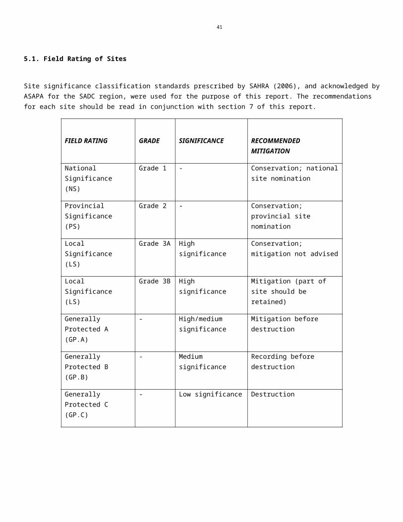
41
Impact rating Site 1 and 2
Component Activity Aspect Impact Rating before mitigation
Summary of mitigation measures/action plans
Rating after mitigation
Construction and Preconstruction phase
Ground clearing
Excavations
Heritage Sites Destruction of heritage sites and depletion of archaeological record of the area.
High Negative (-17) The following mitigation measures are recommended for Site 1 and 2: All sites should be recorded prior to destruction. Test excavation is recommended where archaeological deposit occurs; Mapping of the stone walled sites should be conducted. For the Stone Age component at Site 2 a representative surface sample must be collected for analysis.
Medium negative (-13)
Component Activity Aspect Impact
Pre-mitigation:
Recommended mitigation
Post-mitigation:
Status Certainty
Frequency
Spatial Intensity Duration Significanc
e Status Certainty
Frequency
Spatial Intensity Duration Signifi-
cance
Construction and pre
construction phase
Ground clearing
and excavation
s
Heritage Sites
Destruction of heritage sites during construction.
Negative (-1)
Probable (3)
Continuous (4)
Local (2)
VERY INTENSE (4)
Permanent (4)
High – negative ( -17)
The following mitigation measures are recommended: All sites should be recorded prior to destruction. Test excavation is recommended where archaeological deposit occurs; Mapping of the stone walled sites should be conducted. For the Stone Age component at Site 2 a representative sample must be collected for analysis.
Negative
Probable (3)
Infrequent (2)
Local (2)
MODERATELY INTENSE (2)
Permanent (4)
Medium negative (-13)
A negative impact (1) X (certainty + frequency + extent + intensity + duration) = RATING

42
IMPACT DESCRIPTION: Iron Age and Stone Age sites and site indicators will be permanently destroyed during construction and pre construction phasesPredicted for project phase:
Pre-construction Construction Operation Decommissioning
Dimension Rating MotivationPRE-MITIGATION
Status Negative (-1)
Heritage sites will be destroyed resulting in the depletion of the archaeological record of the area.
Significance: High - negative(-17)
Certainty Probable (3)Heritage sites will be destroyed during preconstruction and construction phases.
Frequency Continuous (4)The sites will be permanently destroyed due to construction activities.
Spatial Local (2)Destruction of the sites will impact on the archaeological record of the area.
Intensity VERY INTENSE (4)
When heritage sites are destroyed the impact is irreversible and permanent.
Duration Permanent (4) Damage to heritage sites is permanent and irreversible.
MITIGATION:
Both sites should be recorded prior to destruction. Test excavation is recommended where archaeological deposits occur; Mapping of the stone walled sites should be conducted. For the Stone Age component at Site 2 a representative surface sample must be collected for analysis.
POST-MITIGATION
Status Negative (-1)
Heritage sites will be destroyed resulting but mitigation will prevent depletion of the archaeological record of the area.
Significance: Medium - negative(-13)
Certainty Probable (3)Sites will still be destroyed during preconstruction and construction phases.
Frequency Infrequent (2)Mitigation measures will ensure that sites are preserved through recording.
Spatial Local (2)
Destruction of the sites will impact on the archaeological record of the area. Recording the sites will ensure that the information offered is preserved.
Intensity MODERATELY INTENSE (2)
When heritage sites are destroyed the impact is irreversible and permanent, through mitigation sites are recorded and the archaeological database of the area will not be depleted.
Duration Permanent (4) Damage to heritage sites is permanent and irreversible.

43
7. RECOMMENDATIONS AND CONCLUSIONS
CRM surveys, e.g. van Schalkwyk (2004), van der Walt (2009) conducted adjacent to the study area and Huffman (2006) to the north provides a good basis for understanding the local archaeology. From these studies it is clear that evidence for Iron Age activity will most likely be concentrated along water courses and rocky outcrops or hills marked by ceramic clusters or dry stone walling. MSA material is also found in these areas especially at the base of hills and along watercourses. During the archival study documents were found indicating that the farm Zwartkop and Middellaagte on which the proposed project is located was established during the 19th century. Four sites were recorded within the area earmarked for the additional opencast and underground mining and processing activities.
Site 1 and 2 are associated with the Later Iron Age. No decorated ceramics were found here but decorated ceramics found in the area represent stamped ware and could possibly be related to the Rooiberg facies (van der Walt 2009), but a bigger ceramic sample is needed to confirm this. Due to site layout of stone walled settlments to the south of the study area these sites could be important because they could hold clues to the interaction between the Uitkoms ceramic facies and Madikwe that formed Rooiberg (van der Walt 2009). The sites were given a medium significance rating due to the unique nature of the sites, the integrity of the archaeological/cultural heritage deposits the wider historic, archaeological and geographic context of the site and the location of the site in relation to other similar sites or features.
The current opencast pit that impacted negatively on Site 1 warrants rescue mitigation on this site to try and retrieve any data lost to the non-renewable heritage resource. Mitigation will include mapping and text excavations at Site 1 and the mapping of Site 2 to reconstruct the settlement pattern that was lost at Site 1 as well as possible text excavations. This assessment is based on the findings from the 2009 assessment and due to access restrictions during the current assessment it is recommended that the site is revisited to determine the status quo of the site. The results of this assessment will determine the decision if the site should then be mapped and test excavated.
For the Stone Age component at Site 2 a representative surface sample must be collected for analysis.
After the documentation of these sites the developer can apply for a permit to destroy the sites
Site 3 and Site 5
Both these sites are outside of the impact area of the proposed developments and no further action is necessary for these sites.
Site 4The site is of medium significance as it forms part of the national estate as described in the NHRA and is older than 60 years and protected by legislation. As per the current lay out the site will not be impacted on and no further action is necessary for the site.
General It is recommended that a heritage resources management plan must be developed for managing the heritage
resources in the study area during construction and operation of the development. This can include basic training for construction staff on possible finds, action steps for mitigation measures and communication routes to follow in the case of a discovery.
It is recommended that a heritage audit report is compiled together with the heritage management plan that will include the status quo of sites previously identified.
According to the paleontological map the paleontological sensitivity of the area is insignificant and according to SAHRIS no further studies are required.
Any change to the current layout will have to be assessed by an archaeologist/heritage specialist.
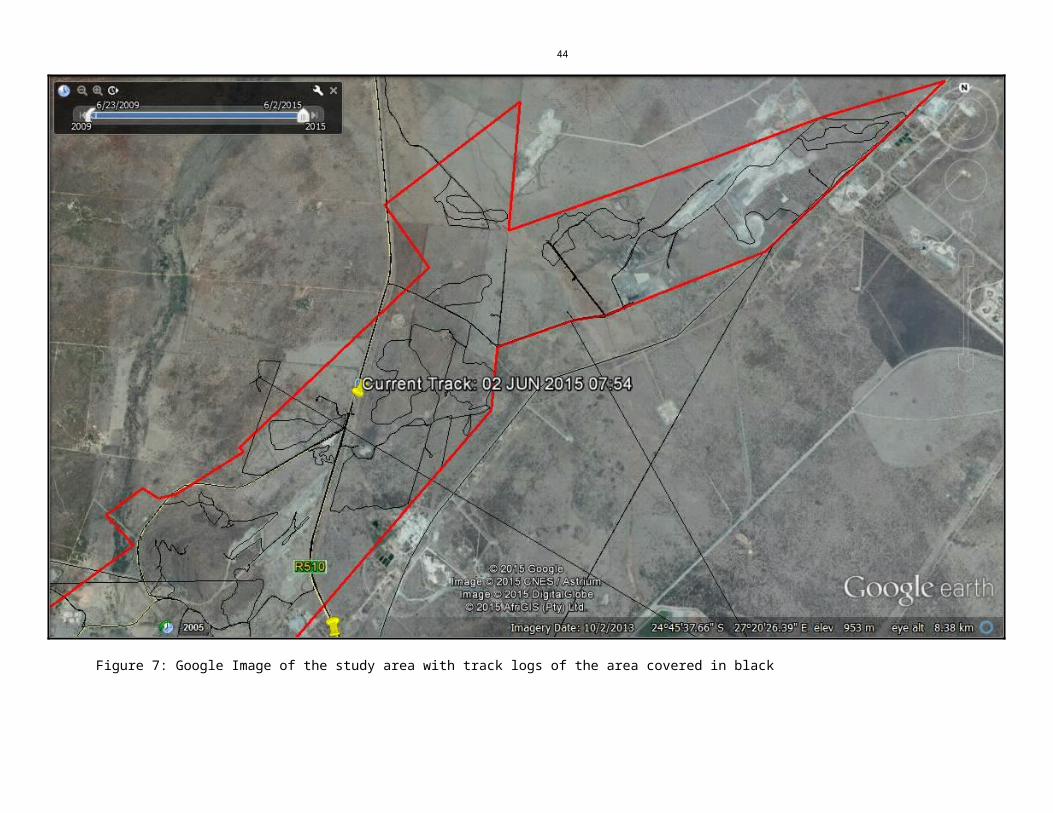
44
Chance finds procedure
This procedure applies to the developer’s permanent employees, its subsidiaries, contractors and subcontractors, and service providers. The aim of this procedure is to establish monitoring and reporting procedures to ensure compliance with this policy and its associated procedures. Construction crews must be properly inducted to ensure they are fully aware of the procedures regarding chance finds as discussed below.
If during the construction, operations or closure phases of this project, any person employed by the developer, one of its subsidiaries, contractors and subcontractors, or service provider, finds any artefact of cultural significance, this person must cease work at the site of the find and report this find to their immediate supervisor, and through their supervisor to the senior on-site manager.
It is the responsibility of the senior on-site Manager to make an initial assessment of the extent of the find, and confirm the extent of the work stoppage in that area.
The senior on-site Manager will inform the ECO of the chance find and its immediate impact on operations. The ECO will then contact a professional archaeologist for an assessment of the finds who will notify the SAHRA.
7.1 Reasoned Opinion If the above recommendations are adhered to and based on approval from SAHRA, HCAC is of the opinion that the development can continue as the impact of the development on heritage resources is acceptable after mitigation measures were implemented successfully prior to the construction phase. If during construction, any archaeological finds are made (e.g. graves, stone tools, and skeletal material), the operations must be stopped, and the archaeologist must be contacted for an assessment of the finds.
7.2 Environmental Impact StatementAn Archaeological impact assessment has been conducted for the proposed additional opencast and underground mining, associated infrastructure and processing activities on portions of the farms Middellaagte 382 KQ, Zwartkop 369 KQ, Elandskuil 378 KQ and Roodedam 368 KQ. The proposed project area reported upon herein is moderately large. However, any negative impacts to the heritage of the region will be limited to the footprint area of the final development area. The extent of any impacts is accordingly characterised as local. The combined assessments recorded 5 heritage sites within the proposed expansion areas. Only two of these will be directly impacted by the proposed development: Site 1 and 2 (Iron Age and Stone Age Sites) by the proposed pits and access routes on the farm Zwartkop. If the mitigation measures in Section 7 are adhered to the impact to heritage resources of the area is acceptable.
8. PROJECT TEAM
Jaco van der Walt, Project Manager
9. STATEMENT OF COMPETENCY
I (Jaco van der Walt) am a member of ASAPA (no 159), and accredited in the following fields of the CRM Section of the association: Iron Age Archaeology, Colonial Period Archaeology, Stone Age Archaeology and Grave Relocation. This accreditation is also valid for/acknowledged by SAHRA and AMAFA.
I have been involved in research and contract work in South Africa, Botswana, Zimbabwe, Mozambique, Tanzania and the DRC; having conducted more than 400 AIAs since 2000.

45
10. REFERENCES
Archaeological Database. University of the Witwatersrand
Bergh, J.S. (red.) 1998. Geskiedenisatlas van Suid Afrika. Die viernoordelike provinsies. J.L. van Schaik: Pretoria.
Breutz, P. L. 1953. Union of South Africa. Department of Native Affairs. Ethnological Publications No. 28. The Tribes of Rustenburg and Pilansberg Districts. Pretoria: The Government Printer.
Coertze, R. D. 1971. Die familie-, erf- en opvolgingsreg van die Bafokeng van Rustenburg: met verwysing na prosesregtelike aspekte. Pretoria: Sabra.
Coetzee, N. A. 1997. Die geskiedenis van Rustenburg ongeveer van 1840 tot 1940. Pretoria: V&R Drukkery (Edms) Bpk.
Deacon, H.J., Deacon, J., 1999.Human beginnings in South Africa. David Philip, Cape Town.
Deeds office, Pretoria.Database information 1367526. Documents on Cultural Heritage Protection. 2002.
Friede, H. & Steel, R.H. 1986. Traditional smithing and forging of South African bloomery iron.
South African Archaeological Bulletin 41: 81-86.
Huffman, T.N. 2006. Archaeological Mitigation of the Rhino Mine. Unpublished report.
Huffman, T.N. 2007.A Handbook to the Iron Age: The Archaeology of Precolonial Farming Societies in Southern Africa.Pietermaritsberg: Kwazulu-Natal University Press
Kuman, K., 1998. The earliest South African Industries. In: Lower Palaeolithic Settlement of the Old World. Eds by M.D. Petraglia and R. Korisetter, pp 151-186. Routledge Press, London.
Lewis-Williams, J.D., 1981. Believing and Seeing: Symbolic Meanings in southern San Rock Paintings. Academic Press, London.
Lombard, M. 2011. Background to the Stone Age of the Kakamas/Keimoes area for CRM purposes. Unpublished report.
Mason, R.J. 1986. Origins of Black People of Johannesburg and the Southern Western Central Transvaal AD 350-1880. (Occasional Paper 16) Johannesburg: University of the Witwatersrand Archaeological Research unit
Massie, R. H. 1905. The Native tribes of Transvaal. Prepared for the General Staff War Office. London: His Majesty's Stationery Office.
Readers Digest. 1992. Illustrated history of South Africa. The Real Story. Expanded second edition: completely updated. Cape Town: Readers Digest Association.
Rosenthal, E. 1979. Rustenburg romance : the history of a Voortrekker town. Johannesburg: Perskor.
Ross, R. 2002. A concise history of South Africa. Cambridge: Cambridge University Press.
ARCHIVAL SOURCES (National Archive, Pretoria)
National Archives of South Africa. 1904-1931. TAB_TED_1999_E419. Middellaagte School. Rustenburg Establishment.
National Archives of South Africa. 1921. 2/234. Union of South Africa. Province of Transvaal. Magisterial District of Rustenburg.

46
National Archives of South Africa. 1933. SAB_URU_1376_2068. Issue of Crown Grant to J. S. Viljoen in respect of farm “Middellaagte” No. 997 Rustenburg.
National Archives of South Africa. 1935-1944. TAB_TED_2000_E419. Middellaagte School. Rustenburg. Establishment.
National Archives of South Africa. 1937. SAB_VWR_133_B645/203/460. Aansoek deur plaaseienaar Middellaagte. F. E. le Roux. Bywoner N. J. Le Roux.
National Archives of South Africa. 1938. SAB_VWR_134_B645/203/512. Aansoek deur plaaseienaar Middellaagte. J. N. van den Bergh. Bywoner J. N. van den Bergh.
National Archives of South Africa. 1973. SAB_BAO_2515_C31/3/1059/13. Enkelkwartiere. Rustenburg Platinum Mines Amandelbult, Thabazimbi.
National Archives of South Africa. 1973. SAB_BAO_2515_C31/3/1059/13. Enkelkwartiere. Rustenburg Platinum Mines Amandelbult.
National Archives of South Africa. 1974-1980. SAB_CDB_2225_PB/1/11/2/17. Plaaslike bestuur. Gemeenskapsvorming. Vrystelling t.o.v. dorpstigting. Amandelbult Myn op Amandelbult KQ en ander.
National Heritage Resources Act 1999
Van der Walt, J. 2009. Archaeological Impact Assessment Chronimet Opencast/Underground Mine And Process Plant, Amandelbult, Limpopo Province.
Van der Walt, J. 2014. Archaeological Impact Assessment For the proposed Zwartkop Industrial Development, Amandelbult, Limpopo Province.
Van Schalkwyk, J. 2004. . Unpublished report on The Surveying And Mapping Of Archaeological Sites On The Farm Elandsfontein 386 KQ, Amandelbult Platinum Mine Thabazimbi District, Limpopo Province
Volman, T.P., 1984. Early prehistory of southern Africa. In: Southern African Prehistory and Paleoenvironments. Ed by R.G. Klein, pp. 169-220. A.A. Balkema, Rotterdam.
Wadley, L., 1987. Later Stone Age Hunters and Gatherers of the southern Transvaal. BAR International Series 380, Oxford.
MAPS
Topographical Map of the Middellaagte 382 KQ area. N/d.
Electronic Sources:
Anglo Platinum. 2011. Operations review. Overview: mining. Amandelbult section. [Online]. Available: http://www.angloplatinum.com/investors/reports/ar_03/b_rprt/pdf_files/page35.pdf . [Cited 16 December 2011].
Google Earth. 2011. 23°28’54.36 S 28°00’49.14” elev 1073m. [Online]. [Cited 18 December 2011].
SAHRIS [Cited 3 July 2015]
Volman, T.P., 1984. Early prehistory of southern Africa. In: Southern African Prehistory and Paleoenvironments. Ed by R.G. Klein, pp. 169-220. A.A. Balkema, Rotterdam.
Wadley, L., 1987. Later Stone Age Hunters and Gatherers of the southern Transvaal. BAR International Series 380, Oxford.