Embed Size (px)
Citation preview
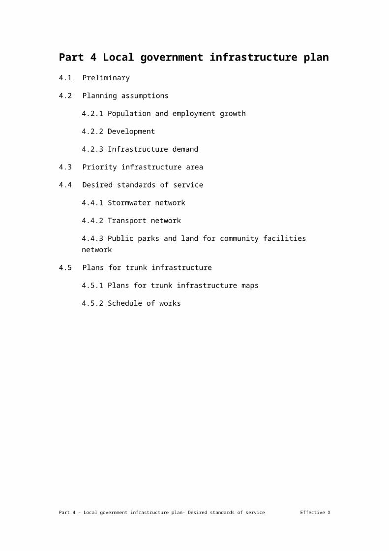
Part 4 Local government infrastructure plan
4.1 Preliminary
4.2 Planning assumptions
4.2.1 Population and employment growth
4.2.2 Development
4.2.3 Infrastructure demand
4.3 Priority infrastructure area
4.4 Desired standards of service
4.4.1 Stormwater network
4.4.2 Transport network
4.4.3 Public parks and land for community facilities network
4.5 Plans for trunk infrastructure
4.5.1 Plans for trunk infrastructure maps
4.5.2 Schedule of works
Part 4 – Local government infrastructure plan- Desired standards of service Effective X

4.1 Preliminary
(1) This local government infrastructure plan has been prepared in accordance with the requirements of the Act.
(2) The purpose of the local government infrastructure plan is to:
(a) integrate infrastructure planning with the land use planning identified in the planning scheme;
(b) provide transparency regarding a local government’s intentions for the provision of trunk infrastructure;
(c) enable a local government to estimate the cost of infrastructure provision to assist its long term financial planning;
(d) ensure that trunk infrastructure is planned and provided in an efficient and orderly manner;
(e) provide a basis for the imposition of conditions about infrastructure on development approvals.
Note—
The water supply network and sewerage network related information is now included in Queensland Urban Utilities' (QUU) water netserv plan. Further details can be obtained by visiting www.urbanutilities.com.au.
(3) The local government infrastructure plan:
(a) states in section 4.2 (Planning assumptions) the assumptions about future growth and urban development including the assumptions of demand for each trunk infrastructure network;
(b) identifies in section 4.3 (Priority infrastructure area) the prioritised area to accommodate urban growth up to 2026;
(c) states in section 4.4 (Desired standards of service) for each trunk infrastructure network the desired standard of performance;
(d) identifies in section 4.5 (Plans for trunk infrastructure) the existing and future trunk infrastructure for the following networks:
(i) stormwater network;
(ii) transport network (road network);
(iii) transport network (pathway network);
(iv) transport network (ferry terminals network);
(v) transport network (bus stops network);
Part 4 – Local government infrastructure plan- Desired standards of service Effective X
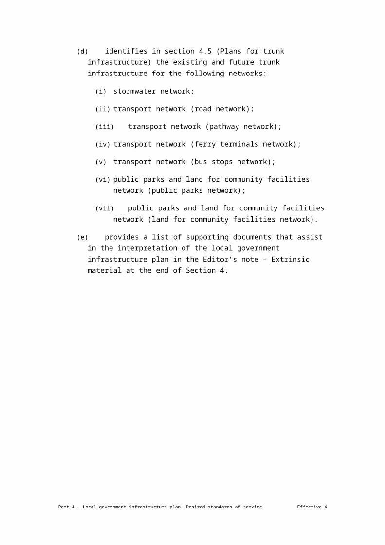
(vi) public parks and land for community facilities network (public parks network);
(vii) public parks and land for community facilities network (land for community facilities network).
(e) provides a list of supporting documents that assist in the interpretation of the local government infrastructure plan in the Editor’s note – Extrinsic material at the end of Section 4.
Part 4 – Local government infrastructure plan- Desired standards of service Effective X

4.2 Planning assumptions
(1) The planning assumptions state the assumptions about:
(a) population and employment growth;
(b) the type, scale, location and timing of development including the demand for each trunk infrastructure network.
(2) The planning assumptions together with the desired standards of service form a basis for the planning of the trunk infrastructure networks and the determination of the priority infrastructure area.
(3) The planning assumptions have been prepared for:
(a) the base date (2016) and the following projection years to accord with future Australian Bureau of Statistics census years:
(i) mid 2016;
(ii) mid 2021;
(iii) mid 2026;
(iv) mid 2031;
(v) beyond mid 2031 (ultimate development).
(b) the LGIP development types in column 2 that include the uses in column 3 of Table 4.2.1;
(c) the projection areas identified on Map A2 Priority Infrastructure Area and Projection Areas in Schedule 3—Local government infrastructure plan mapping and tables.
Table 4.2.1—Relationship between LGIP development categories, LGIP development types and uses
Column 1
LGIP development category
Column 2
LGIP development type
Column 3
Uses
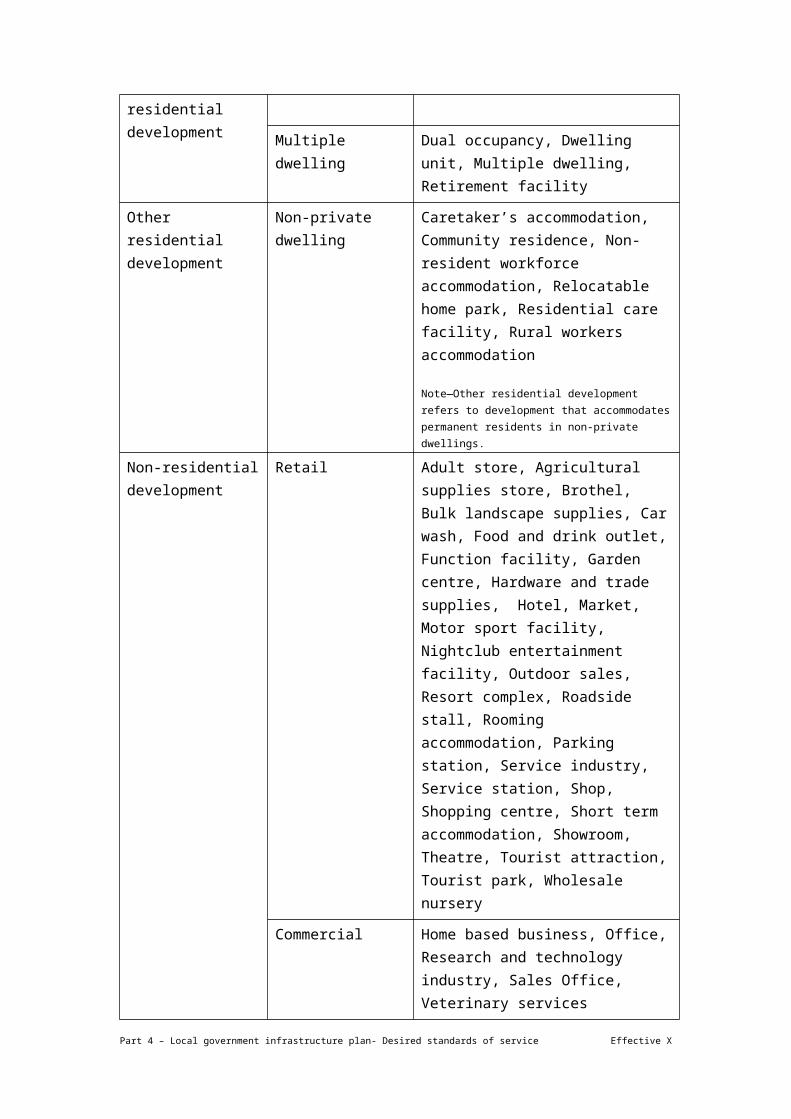
Private residential development
Dwelling house Dwelling house
Multiple dwelling Dual occupancy, Dwelling unit, Multiple dwelling, Retirement facility
Other residential development
Non-private dwelling Caretaker’s accommodation, Community residence, Non-resident workforce accommodation, Relocatable home park, Residential care facility, Rural workers
Part 4 – Local government infrastructure plan- Desired standards of service Effective X
accommodation
Note—Other residential development refers to development that accommodates permanent residents in non-private dwellings.
Non-residential development
Retail Adult store, Agricultural supplies store, Brothel, Bulk landscape supplies, Car wash, Food and drink outlet, Function facility, Garden centre, Hardware and trade supplies, Hotel, Market, Motor sport facility, Nightclub entertainment facility, Outdoor sales, Resort complex, Roadside stall, Rooming accommodation, Parking station, Service industry, Service station, Shop, Shopping centre, Short term accommodation, Showroom, Theatre, Tourist attraction, Tourist park, Wholesale nursery
Commercial Home based business, Office, Research and technology industry, Sales Office, Veterinary services
Industrial Air services, High impact industry, Landing, Low impact industry, Marine industry, Medium impact industry, Port services, Special industry, Telecommunications facility, Transport depot, Warehouse, Winery
Community purpose Cemetery, Child care centre, Club, Community care centre, Community use, Crematorium, Detention facility, Educational establishment, Emergency services, Environment facility, Funeral parlour, Health care services, Hospital, Indoor sport and recreation, Major sport, recreation and entertainment facility, Nature based tourism, Outdoor sport and recreation, Park, Place of worship
Other Animal husbandry, Animal keeping, Aquaculture, Cropping, Extractive industry, Intensive animal industry, Intensive horticulture, Major electricity infrastructure, Permanent plantation, Renewable energy facility, Rural industry,
Part 4 – Local government infrastructure plan- Desired standards of service Effective X

Substation, Utility installation
Mobile worker Note—There is no planning scheme use definition for mobile workers. Mobile workers include workers that have no fixed place of work e.g. construction workers.
(4) Details of the methodology used to prepare the planning assumptions are stated in the extrinsic material.
4.2.1 Population and employment growth
(1) A summary of the assumptions about population and employment growth for the planning scheme area is stated in Table 4.2.1.1.
Table 4.2.1.1—Population and employment assumptions summary
Column 1 Column 2
Description Assumptions
Base date(2016)
2021 2026 2031 Ultimate development
Population 1,164,862 1,224,585 1,279,119 1,342,550 1,529,197
Employment 848,682 928,708 1,003,392 1,083,306 1,610,196
(2) Detailed assumptions about growth for each projection area and LGIP development type category are identified in the following tables in Schedule 3—Local government infrastructure plan mapping and tables:
(a) for population, Table SC3.1.1;
(b) for employment, Table SC3.1.2.
4.2.2 Development
(1) The developable area is represented by zones relating to urban uses not affected by developable area constraints stated in Table 4.2.2.1.
Table 4.2.2.1— Developable area constraints
Developable area constraint Applicable components
Biodiversity areas overlay High ecological significance and Priority koala habitat area sub categories.
Extractive resources overlay Key Resource Area (KRA) resource/processing area, KRA
Part 4 – Local government infrastructure plan- Desired standards of service Effective X

separation area, KRA transport route separation area and KRA transport route sub-categories.
Flood overlay Brisbane River flood planning area 1 and Creek/waterway flood planning area 1 sub-categories.
Regional infrastructure corridors and substations overlay
Roma to Brisbane gas pipeline 20m, Moonie to Brisbane oil pipeline 15m and Major electricity infrastructure high voltage powerline easement sub-categories.
Road hierarchy overlay Future arterial road (20m buffer) sub-category.
Waterway corridors overlay Brisbane River corridor and Citywide waterway corridor sub-categories.
Wetlands overlay Wetland sub-category.
Slope Greater than 25%
(2) The planned density for future development is stated in Table SC3.1.3 in Schedule 3—Local government infrastructure plan mapping and tables.
(3) A summary of the assumptions about future residential and non-residential development for the planning scheme area is stated in Table 4.2.2.2.
Table 4.2.2.2—Residential dwellings and non-residential floor space assumptions summary
Column 1 Column 2
Description Assumptions
Base date(2016)
2021 2026 2031 Ultimate development
Residential dwellings
454,019 486,941 513,915 545,262 629,938
Non-residential floor space (m² GFA)
34,805,370 37,517,792 40,498,863 43,539,118 58,762,090
(4) Detailed assumptions about future development for each projection area and LGIP development type are identified in the following tables in Schedule 3—Local government infrastructure plan mapping and tables:
(a) for residential development, Table SC3.1.4;
(b) for non-residential development, Table SC3.1.5.
Part 4 – Local government infrastructure plan- Desired standards of service Effective X

4.2.3 Infrastructure demand
(1) The demand generation rate for a trunk infrastructure network is stated in column 3 of Table SC3.1.3 in Schedule 3—Local government infrastructure plan mapping and tables.
(2) A summary of the projected infrastructure demand for each service catchment is stated in the following tables in Schedule 3—Local government infrastructure plan mapping and tables:
(a) for the stormwater network, Table SC3.1.6;
(b) for the transport network, Table SC3.1.7, Table SC3.1.8 and Table SC3.1.9;
(c) for the public parks and land for community facilities network, Table SC3.1.10, Table SC3.1.11 and Table SC3.1.12.
Part 4 – Local government infrastructure plan- Desired standards of service Effective X

4.3 Priority infrastructure area
(1) The priority infrastructure area identifies the area prioritised for the provision of trunk infrastructure to service the existing and assumed future urban development up to 2026.
(2) The priority infrastructure area is identified on Local Government Infrastructure Plan Map A1 Priority Infrastructure Area.
Part 4 – Local government infrastructure plan- Desired standards of service Effective X

4.4 Desired standards of service
(1) This section states the key standards of performance for a trunk infrastructure network.
(2) Details of the standard of service for a trunk infrastructure network are identified in the extrinsic material.
Editor’s Note—The desired standards of service provides a high level summary of the key planning and design standards of performance for a network of development infrastructure which comprises both non-trunk and trunk infrastructure. Non-trunk infrastructure must comply with the conversion criteria in the relevant charges resolution to be converted to trunk infrastructure.
4.4.1 Stormwater network
The desired standard of service for the stormwater network is as follows:
(a) to collect and convey stormwater flows during both major and minor flood events from existing and future land use, in a manner that minimises risk to property and life and reduces the cost of flood damage to the community;
(b) to achieve the appropriate level of flood immunity required by:
(i) Stormwater code;
(ii) Flood overlay code;
(iii) Infrastructure design planning scheme policy;
(iv) any other applicable code or standards in a local planning instrument.
(c) to achieve water quality objectives for receiving waters in accordance with the Infrastructure design planning scheme policy;
(d) to maximise or maintain the use of existing overland flow paths and waterway corridors as the major conveyance elements of the network;
(e) for items of stormwater infrastructure to be designed and delivered in accordance with the conveyance and design standards required by:
(i) the minimum desired capacity of minor and major drainage infrastructure is to be in accordance with the Infrastructure design planning scheme policy;
(ii) the maximum total depth of flow in a roadway is to be in accordance with the Infrastructure design planning scheme policy;
(iii) any other applicable codes and standards in a local planning instrument.
Part 4 – Local government infrastructure plan- Desired standards of service Effective X

4.4.2 Transport network
4.4.2.1 Road network
The desired standard of service for the road network is as follows:
(a) provide a functional road hierarchy that supports the settlement pattern, commercial and economic activity and transport movement;
(b) support economic development through the efficient movement of transport and freight by maintaining and enhancing critical links and intersections connecting residential areas to employment areas, centres, education facilities and mixed use sites according to the Road hierarchy overlay code;
(c) district roads service a catchment of approximately 3,000 households for inner suburbs (within 5km of the CBD) and approximately 1,000 households for outer suburbs;
(d) plan, design and deliver the road network and associated infrastructure to comply with the following:
(i) the functional road hierarchy classification (as identified on the Road hierarchy overlay map), traffic flow, connectivity, safety and access in accordance with the Infrastructure design planning scheme policy and the Road hierarchy overlay code;
(ii) Infrastructure design planning scheme policy;
(iii) Road hierarchy overlay code;
(iv) the off-peak operation of the road network provides a level of service C;
(v) the peak period operation of the road network provides a level of service C, except where the road network is highly constrained and the use of alternative modes of transport in these areas is anticipated in the mode share targets stated in Map C3 Transport Network DSS Mode Share Targets;
(vi) the road network is planned to provide for future capacity needs in accordance with the Road hierarchy overlay map and Road hierarchy overlay code.
4.4.2.2 Pathway network
The desired standard of service for the pathway network is as follows:
(a) provide a safe, attractive and convenient pedestrian and cycle pathway network that links residential areas to employment areas, major activity nodes, education facilities and public transport interchanges, thereby encouraging walking and cycling as acceptable travel alternatives;
Part 4 – Local government infrastructure plan- Desired standards of service Effective X

(b) plan, design and deliver the pathway network and associated infrastructure to comply with the following:
(i) the pathway network classification (as identified on the Bicycle network overlay map), connectivity, safety and access in accordance with the Infrastructure design planning scheme policy and the Bicycle network overlay code;
(ii) Infrastructure design planning scheme policy (Chapters 1 and 4);
(iii) Bicycle network overlay code;
(iv) pathways are planned to provide for future demand needs in accordance with the Bicycle network overlay map and the Bicycle network overlay code.
4.4.2.3 Public transport (bus stops) network
The desired standard of service for bus stops is as follows:
(a) provide public transport infrastructure to support the future mode share targets stated in Map C3 Transport Network DSS Mode Share Targets including bus stops and stations;
(b) provide a public transport stop within 400m of 90% of all urban dwellings (15 or more dwellings per hectare (existing or planned));
(c) the design of bus stops and associated infrastructure is to comply with the Infrastructure design planning scheme policy;
(d) maintain or improve network coverage through provision, upgrading and maintenance of infrastructure.
4.4.2.4 Public transport (ferry terminals) network
The desired standard of service for ferry terminals is as follows:
(a) provide public transport infrastructure to support the future mode share targets stated in Map C3 Transport Network DSS Mode Share Targets including Ferry and CityCat terminals;
(b) maintain or improve network coverage through provision, upgrading and maintenance of infrastructure.
4.4.3 Public parks and land for community facilities network
4.4.3.1 Public parks network
The desired standard of service for the public parks network is as follows:
Part 4 – Local government infrastructure plan- Desired standards of service Effective X

(a) provide a diverse, well-connected, accessible and equitable network that meets community needs across Brisbane in accordance with the following:
(i) the trunk infrastructure summary stated in Table 4.4.3.1.1 (and the Brisbane Park Classification System in the Infrastructure design planning scheme policy);
(ii) the desired rate of provision standards stated in Table 4.4.3.1.2;
(iii) the desired accessibility standards stated in Table 4.4.3.1.3;
(iv) the desired size standards stated in Table 4.4.3.1.4;
(v) the desired embellishment standards stated in Table 4.4.3.1.5;
(vi) flood and stormwater provisions in the Flood overlay code, Waterways corridors overlay code, Park planning and design code and Chapter 10 of the Infrastructure design planning scheme policy;
(vii) provisions for acceptable gradients in the Park planning and design code and Chapter 10 of the Infrastructure design planning scheme policy;
(viii) any other applicable code or standards in a local planning instrument.
Note—The desired standard of service for Public Parks apply across either of two identified service areas, namely Brisbane-wide, which includes all mainland areas of the Brisbane Local Government Area, and the Local Recreation Need Area, which comprises an area consistent with Brisbane’s Centres, Suburban Living Area and Future Suburban Living Area defined in the SFM-002 Brisbane CityShape 2031 Land Use Strategic Framework Map and includes the following zones – LDR, CR1, CR2, LMR1, LMR2, LMR3, MDR, HDR1, HDR2, NC, DC1, DC2, MC, PC1, PC2, PDA1, PDA2, PDA3, PDA4, SBCA, EC, MU1, MU2, MU3.
Note—It is assumed that residents living within the Local Recreation Need Area place an additional demand on the park network than those who live outside the Local Recreation Need Area. Those outside of the Local Recreation Need Area live in a more open, rural environment and would typically have ready access to private open space for their local recreation needs. Desired standard of service areas are identified in Map D2 - Public Parks Network DSS Areas.
Table 4.4.3.1.1—Public Park Trunk Infrastructure Summary
Trunk Type Applicable Park Classification Categories
Park Type Park Sub Type Park Hierarchy
Sport Sport General Outdoor Sport Local/District/Metro
Sport Specialised Outdoor Sport
Local/District/Metro
Recreation (Urban)⁽¹⁾ Recreation General Recreation Local/District/Metro
Recreation Botanic Garden/Arboretum
District/Metro
Recreation Urban Common District/Metro
Recreation (Natural) ⁽²⁾
Corridor Access/Recreation Corridor
Local/District/Metro
Part 4 – Local government infrastructure plan- Desired standards of service Effective X

Natural Area Visitor Node District/Metro
Natural Area Nature Recreation Local/District/Metro
Editor’s note—
(1) Recreation (Urban) parks provide for a range of formal and informal recreation opportunities in an urban setting and generally have a high level of infrastructure and high servicing/maintenance requirements.
(2) Recreation (Natural) parks provide for a range of formal and informal recreation opportunities in a mostly natural setting (e.g. waterway, bushland) and generally have a low level of infrastructure and low servicing/maintenance requirements.
Table 4.4.3.1.2—Provision standard for the public parks trunk infrastructure network
Trunk Type
Applicable Park Classification Categories
Service Area
Rate
Ha/1000 persons⁽¹⁾
Park Type/ Sub Type
Park Hierarchy
Population (residents)
Employees
Sport Sport – General Outdoor Sport
Sport – Specialised Outdoor Sport
Local/ District/ Metropolitan
Brisbane-wide
1.2 NA
Recreation (Urban)
Recreation – General Recreation
Recreation – Botanic Garden/ Arboretum
Local Local Recreation Need Area
0.8 0.1
District/ Metropolitan
Brisbane-wide
0.8 0.2
Recreation – Urban Common⁽²⁾
District/
Metropolitan
Brisbane-wide
0.006 0.006
Recreation (Natural)
Corridor – Access/ Recreation Corridor
Natural Area – Visitor Node
Natural Area – Nature Recreation
Local Local Recreation Need Area
0.6 N/A
District/ Metropolitan
Brisbane-wide
0.8 N/A
Note—
Part 4 – Local government infrastructure plan- Desired standards of service Effective X

(1) The rate of land provision should be calculated based on either residents or employees (not the aggregate of both), whichever represents peak demand i.e. whichever requires the greater provision of park land.
(2) For network planning purposes the provision standard for Urban Commons is based on a desired number of parks per Principal, Major or District Centre because these parks are integral to a centre and service both residents within and visitors to a centre. The desired provision standard for urban commons is as follows: Up to 1 per District centre (District zone precinct or Corridor zone precinct) e.g. West End, 1 per Major centre or Principal centre (Regional centre zone precinct) e.g. Upper Mt Gravatt and 5+ per Principal centre (City Centre zone precinct) e.g. Post Office Square.
Table 4.4.3.1.3—Accessibility standard for the public parks trunk infrastructure network
Trunk Type Applicable Park Classification Categories Service Area Distance to Park
(Desired Max.)
Park Type/ Sub Type Park Hierarchy
Sport Sport – General Outdoor Sport
Sport – Specialised Outdoor Sport
Local/District/ Metropolitan
Local Recreation Need Area
3km
Outside Local Rec’n Need Area
5km
Recreation (Urban)
Recreation – General Recreation
Recreation – Botanic Garden/ Arboretum
Local Local Recreation Need Area
750m
District/ Metropolitan
Local Recreation Need Area
3km
Outside Local Rec’n Need Area
5km
Recreation – Urban Common
District/ Metropolitan
Brisbane-wide 750m from Centre
Recreation (Natural)
Corridor – Access/ Recreation Corridor
Natural Area – Visitor Node
Natural Area – Nature Recreation
Local Local Recreation Need Area
750m
District/ Metropolitan
Local Recreation Need Area
3km
Outside Local Rec’n Need Area
5km
Part 4 – Local government infrastructure plan- Desired standards of service Effective X

Table 4.4.3.1.4—Size standard for the public parks trunk infrastructure network
Trunk Type Applicable Park Classification Categories Service Area Size Ha
(Desired Min.)
Park Type/ Sub Type Park Hierarchy
Sport Sport – General Outdoor Sport
Sport – Specialised Outdoor Sport
Local Brisbane-wide 1.0
District Brisbane-wide 4.0
Metropolitan Brisbane-wide 7.0
Recreation (Urban)
Recreation – General Recreation
Local Local Recreation Need Area
0.8
District/ Metropolitan
Brisbane-wide 3.0
Recreation – Botanic Garden/ Arboretum
District/ Metropolitan
Brisbane-wide 21.0
Recreation – Urban Common
District Brisbane-wide 0.1
Metropolitan Brisbane-wide 0.6
Recreation (Natural)
Corridor – Access/ Recreation Corridor
Natural Area – Visitor Node
Natural Area – Nature Recreation
Local Local Recreation Need Area
0.8
District/ Metropolitan
Brisbane-wide 3.0
Part 4 – Local government infrastructure plan- Desired standards of service Effective X

Table 4.4.3.1.5—Embellishment standard for the public parks trunk infrastructure network
Trunk Type Sport Recreation (Urban) Recreation (Natural)
Park Type/ Sub Type
Sport – General outdoor sport
Sport – Specialised outdoor sport
Recreation – General Recreation
Rec’n – Botanic Garden/ Arb’tm
Rec’n – Urban Common
Corridor – Access/ Recreation Corridor
Natural Area – Visitor Node
Natural Area – Nature Recreation
Park HierarchyLocal
District
Metro Local DistrictMetro
All All LocalDistrict
Metro
AllLocal
District
Metro
Playground/ play space
B B B B B
Picnic facilities B B B B B
Kick-around space B B B
Barbecues B B B
Public toilets B B B B B B
Shade trees B B B B B B B B B
Maintenance taps A A B A A A A A A A A A A
Drinking fountains A B A+B B B B A B B B B B
Part 4 – Local government infrastructure plan- Desired standards of service Effective X

Trunk Type Sport Recreation (Urban) Recreation (Natural)
Park Type/ Sub Type
Sport – General outdoor sport
Sport – Specialised outdoor sport
Recreation – General Recreation
Rec’n – Botanic Garden/ Arb’tm
Rec’n – Urban Common
Corridor – Access/ Recreation Corridor
Natural Area – Visitor Node
Natural Area – Nature Recreation
Park HierarchyLocal
District
Metro Local DistrictMetro
All All LocalDistrict
Metro
AllLocal
District
Metro
Bins A+B B B B A+B A+B A+B B B B B
Seating B A+B B B B B A+B B B
Paths – pedestrian B B B B B A A A A B
Paths - bicycle B B B B C C B B
Bike racks C B B B B C C C
Dog off leash area C C
Half court C C
Rebound wall C C
Skate facility C C
Part 4 – Local government infrastructure plan- Desired standards of service Effective X

Trunk Type Sport Recreation (Urban) Recreation (Natural)
Park Type/ Sub Type
Sport – General outdoor sport
Sport – Specialised outdoor sport
Recreation – General Recreation
Rec’n – Botanic Garden/ Arb’tm
Rec’n – Urban Common
Corridor – Access/ Recreation Corridor
Natural Area – Visitor Node
Natural Area – Nature Recreation
Park HierarchyLocal
District
Metro Local DistrictMetro
All All LocalDistrict
Metro
AllLocal
District
Metro
Sports field/s B B C
Sports court/s B B A + B
Spectator seating C A + B
Garden beds B B B
Internal roads A A A A A A A
Internal car parks A A A A A A A
Fencing A A A A A A A A A A A A A A A
Lighting – pathways B A B B B C C C
Signage A A+B B A A+B A+B A A+B A A+B A+B A+B A+B A+B A+B
Part 4 – Local government infrastructure plan- Desired standards of service Effective X

Trunk Type Sport Recreation (Urban) Recreation (Natural)
Park Type/ Sub Type
Sport – General outdoor sport
Sport – Specialised outdoor sport
Recreation – General Recreation
Rec’n – Botanic Garden/ Arb’tm
Rec’n – Urban Common
Corridor – Access/ Recreation Corridor
Natural Area – Visitor Node
Natural Area – Nature Recreation
Park HierarchyLocal
District
Metro Local DistrictMetro
All All LocalDistrict
Metro
AllLocal
District
Metro
Fitness equipment B B B B B B
Irrigation C B B
Site preparation A A A A A A A A A A A A A A A
Vehicle access incl. gate
A A A A A A A A A A A A A A A
Turfing A A A A A A A A A A A
Bus parking A A A A A B
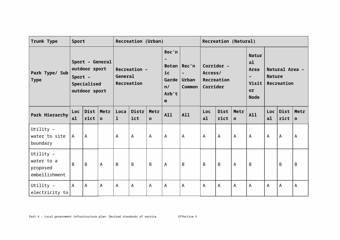
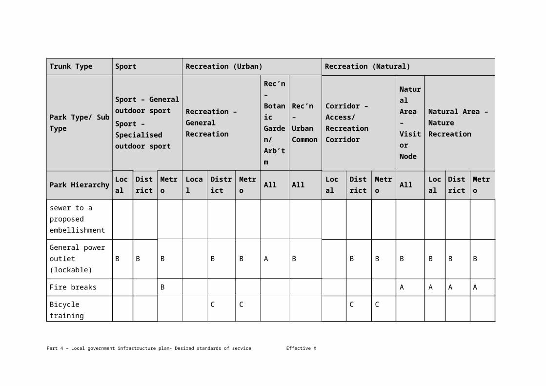
Utility – water to site boundary
A A A A A A A A A A A A A A
Utility – water to a proposed
B B A B B B A B B B A B B B
Part 4 – Local government infrastructure plan- Desired standards of service Effective X

Trunk Type Sport Recreation (Urban) Recreation (Natural)
Park Type/ Sub Type
Sport – General outdoor sport
Sport – Specialised outdoor sport
Recreation – General Recreation
Rec’n – Botanic Garden/ Arb’tm
Rec’n – Urban Common
Corridor – Access/ Recreation Corridor
Natural Area – Visitor Node
Natural Area – Nature Recreation
Park HierarchyLocal
District
Metro Local DistrictMetro
All All LocalDistrict
Metro
AllLocal
District
Metro
embellishment
Utility – electricity to site boundary
A A A A A A A A A A A A A A A
Utility – electricity to a proposed embellishment
B B A B B A A B C B B B B B
Utility – sewer to site boundary
A A B A A A B C C A A A A
Utility – sewer to a proposed embellishment
B B A B B A B C C B B B
General power B B B B B A B B B B B B B
Part 4 – Local government infrastructure plan- Desired standards of service Effective X

Trunk Type Sport Recreation (Urban) Recreation (Natural)
Park Type/ Sub Type
Sport – General outdoor sport
Sport – Specialised outdoor sport
Recreation – General Recreation
Rec’n – Botanic Garden/ Arb’tm
Rec’n – Urban Common
Corridor – Access/ Recreation Corridor
Natural Area – Visitor Node
Natural Area – Nature Recreation
Park HierarchyLocal
District
Metro Local DistrictMetro
All All LocalDistrict
Metro
AllLocal
District
Metro
outlet (lockable)
Fire breaks B A A A A
Bicycle training facility
C C C C
BMX track C C C C
Water play C
Water feature C
Horse/ bike riding path/ trail
C C
Camp ground C
Part 4 – Local government infrastructure plan- Desired standards of service Effective X

Trunk Type Sport Recreation (Urban) Recreation (Natural)
Park Type/ Sub Type
Sport – General outdoor sport
Sport – Specialised outdoor sport
Recreation – General Recreation
Rec’n – Botanic Garden/ Arb’tm
Rec’n – Urban Common
Corridor – Access/ Recreation Corridor
Natural Area – Visitor Node
Natural Area – Nature Recreation
Park HierarchyLocal
District
Metro Local DistrictMetro
All All LocalDistrict
Metro
AllLocal
District
Metro
Bush walking/ hiking path/ trail
C C C
Stormwater harvesting & rainwater tanks
B B C C
Shade structures – free standing
B B B B B C B
Park pavilion (large) B B
Lighting – security B B B B A B B B B
Lighting – sports field/ court
C B
Part 4 – Local government infrastructure plan- Desired standards of service Effective X

Note—
All listed embellishments are trunk infrastructure.
Type A embellishments are the initial essential embellishment conditioned as part of a development approval. Type B embellishments are the medium term embellishment and are intended to be delivered by Brisbane City Council capital projects. Type C embellishments are the ultimate embellishment and are intended to be delivered by Brisbane City Council capital projects.
Site preparation includes the following: site clearing; stripping, stockpiling and re-use of existing site topsoil; earthworks; site drainage; and vegetation management.
Part 4 – Local government infrastructure plan- Desired standards of service Effective X

4.4.3.2 Land for community facilities network
The desired standard of service for the land for community facilities network is to provide an accessible network of land for community facilities that meets the needs of the population and employees in accordance with the following:
(a) the land provision standard for the land for community facilities network stated in Table 4.4.3.2.1 for the areas identified in Map D3 Land for Community Facilities Network DSS Areas;
(b) the accessibility standard for the land for community facilities network stated in Table 4.4.3.2.2 for the areas identified in Map D3 Land for Community Facilities Network DSS Areas;
(c) the service population standard for the land for community facilities network stated in Table 4.4.3.2.3 for the areas identified in Map D3 Land for Community Facilities Network DSS Areas;
(d) the minimum size standard for the land for community facilities network stated in Table 4.4.3.2.4 for the areas identified in Map D3 Land for Community Facilities Network DSS Areas;
(e) future trunk infrastructure for the land for community facilities network meets an acceptable level of flood immunity identified in the Flood overlay code and has a gradient equal to or less than 1V:20H.
Part 4 – Local government infrastructure plan- Desired standards of service Effective X

Table 4.4.3.2.1—Land provision standard for the land for community facilities network
Land for community facilities network type
Service level Land provision (m²/1,000 persons)⁽¹⁾
Area A Centres Area B General urban Area C Fringe
Population Employees Population Employees Population Employees
Community service/leisure Local⁽²⁾ 360 60 360 60 0 60
Community service/leisure District 550 N/A 550 N/A 550 N/A
Community service/leisure Principal 83 N/A 83 N/A 83 N/A
Community service/leisure Metro 11 N/A 11 N/A 11 N/A
Total for community service/leisure
1,004 60 1,004 60 644 60
Arts and culture District 200 N/A 200 N/A 200 N/A
Arts and culture Principal 53 N/A 53 N/A 53 N/A
Total for arts and culture 253 0 253 0 253 0
Sport and recreation⁽³⁾ District 625 200 625 200 625 200
Sport and recreation Principal 233 N/A 233 N/A 233 N/A
Total for sport and recreation 858 200 858 200 858 200
Total land for community facilities network 2,116 260 2,116 260 1,756 260
Part 4 – Local government infrastructure plan- Desired standards of service Effective X

Note—
(1) The rate of land provision is based on the peak demand arising from the population or employees and therefore is not the aggregate of the population and employee demand.
(2) A local community facility is to be provided if part of an industrial area servicing over 20,000 employees.
(3) For sports park refer to the desired standard of service for the public parks trunk infrastructure network
Table 4.4.3.2.2—Accessibility standard for the land for community facilities network
Land for community facilities network type
Service level Distance (kilometres)
Area A Centres Area B General urban Area C Fringe
Population Employees Population Employees Population Employees
Community service/leisure
Community service/leisure Local⁽¹⁾ 1 2 1 2 N/A N/A
Community service/leisure District 2 N/A 2 N/A 5 N/A
Community service/leisure Principal 5 N/A 5 N/A 10 N/A
Community service/leisure Metro N/A N/A N/A N/A N/A N/A
Arts and culture
Arts and culture District 2 N/A 2 N/A 5 N/A
Arts and culture Principal 5 N/A 5 N/A 10 N/A
Part 4 – Local government infrastructure plan- Desired standards of service Effective X
Sport and recreation
Sport and recreation District 3 3 3 3 5 5
Sport and recreation Principal 5 N/A 5 N/A 10 N/A
Note—
(1) A local community facility is to be provided if part of an industrial area servicing over 20,000 employees.
(2) For sports park refer to the desired standard of service for the public parks trunk infrastructure network.
Table 4.4.3.2.3—Service population standard for the land for community facilities network
Land for community facilities network type
Service level Persons
Area A Centres Area B General urban Area C Fringe
Population Employees Population Employees Population Employees
Community service/leisure
Community service/leisure Local⁽¹⁾ 5,000 20,000 5,000 20,000 N/A N/A
Community service/leisure District 20,000-30,000 N/A 20,000–30,000 N/A 20,000–30,000 N/A
Community service/leisure Principal 150,000 N/A 150,000 N/A 150,000 N/A
Community service/leisure Metro 1,200,000 N/A 1,200,000 N/A 1,200,000 N/A
Arts and culture
Part 4 – Local government infrastructure plan- Desired standards of service Effective X

Arts and culture District 20,000 N/A 20,000 N/A 20,000 N/A
Arts and culture Principal 150,000 N/A 150,000 N/A 150,000 N/A
Sport and recreation
Sport and recreation District 40,000 40,000 40,000 40,000 40,000 40,000
Sport and recreation Principal 150,000 N/A 150,000 N/A 150,000 N/A
Note—
(1) A local community facility is to be provided if part of an industrial area servicing over 20,000 employees.
(2) For sports park refer to the desired standard of service for the public parks trunk infrastructure network.
Table 4.4.3.2.4—Minimum size standard for the land for community facilities network
Land for community facilities network
Land for community facilities network sub-type
Service level Area (m²)
Area A Centres Area B General urban Area C Fringe
Population Employees Population Employees Population Employees
Community service/leisure
Community space Local⁽¹⁾ 1,200 1,200 1,200 1,200 N/A N/A
Community space District 2,000 N/A 2,000 N/A 2,000 N/A
Community service/group space
District 2,000 N/A 2,000 N/A 2,000 N/A
Community Principal 4,000 N/A 4,000 N/A 4,000 N/A
Part 4 – Local government infrastructure plan- Desired standards of service Effective X
service/group space
Libraries District 3,000 N/A 3,000 N/A 3,000 N/A
Libraries Principal 6,500 N/A 6,500 N/A 6,500 N/A
Libraries Metro 13,000 N/A 13,000 N/A 13,000 N/A
Arts and culture Visual arts space District 2,000 N/A 2,000 N/A 2,000 N/A
Visual arts space Principal 4,000 N/A 4,000 N/A 4,000 N/A
Performance space District 2,000 N/A 2,000 N/A 2,000 N/A
Performance space Principal 4,000 N/A 4,000 N/A 4,000 N/A
Sport and recreation Indoor sport and recreation facilities
District 8,000 8,000 8,000 8,000 8,000 8,000
Indoor sport and recreation facilities
Principal 15,000 N/A 15,000 N/A 15,000 N/A
Aquatic facilities/swimming pools
District 10,000 N/A 10,000 N/A 10,000 N/A
Aquatic facilities/swimming pools
Principal 20,000 N/A 20,000 N/A 20,000 N/A
Note—
Part 4 – Local government infrastructure plan- Desired standards of service Effective X

(1) A local community facility is to be provided if part of an industrial area servicing over 20,000 employees.
Part 4 – Local government infrastructure plan- Desired standards of service Effective X

4.5 Plans for trunk infrastructure
(1) The plans for trunk infrastructure identify the trunk infrastructure networks intended to service the existing and assumed future urban development at the desired standard of service up to 2026.
Editor’s note—
The water supply network and sewerage network related information is now included in QUU's water netserv plan. Further details can be obtained by visiting www.urbanutilities.com.au.
4.5.1 Plans for trunk infrastructure maps
(1) The existing and future trunk infrastructure networks are shown on the following maps stated in Table 4.5.1.1 which are included in Schedule 3.
Editor’s note—
The location of future trunk infrastructure has been based on feasibility studies. Actual locations will be subject to detailed investigation, designs and Council approval.
Table 4.5.1.1—Plans for trunk infrastructure networks
Column 1
Trunk infrastructure network
Column 2
Plans for trunk infrastructure
Stormwater network Map SW13, SW14, SW31, SW32, SW33, SW34, SW41, SW51, SW52, SW53, SW54, SW71, SW72, SW73, SW74, SW75, SW78, SW91, SW92, SW93, SW94, SW95, SW96, SW97, SW98, SW109, SW110, SW111, SW112, SW113, SW114, SW115, SW116, SW117, SW118, SW123, SW127, SW129, SW130, SW131, SW132, SW133, SW134, SW135, SW136, SW137, SW138, SW149, SW150, SW151, SW152, SW153, SW154, SW155, SW156, SW157, SW167, SW169, SW170, SW171, SW172, SW173, SW174, SW175, SW176, SW177, SW178, SW189, SW190, SW191, SW192, SW193, SW194, SW195, SW196, SW197, SW198, SW203, SW205, SW206, SW207, SW208, SW209, SW210, SW211, SW212, SW213, SW214, SW215, SW216, SW217, SW218, SW225, SW226, SW227, SW228, SW229, SW230, SW231, SW232, SW233, SW234, SW235, SW236, SW237, SW238, SW243, SW245, SW246, SW247, SW248, SW249, SW250, SW251, SW252, SW253, SW254, SW255, SW256, SW257, SW258, SW265, SW266, SW267, SW268, SW269, SW270, SW271, SW272, SW273, SW274, SW275, SW276, SW277, SW278,
Part 4 – Local government infrastructure plan Effective X

SW287, SW288, SW289, SW290, SW291, SW292, SW293, SW294, SW295, SW296, SW297, SW308, SW309, SW310, SW311, SW312, SW313, SW314, SW315, SW317, SW330, SW331, SW332, SW333, SW334, SW335, SW351, SW352, SW353, SW354
Transport network (road network) Map R13, R14, R31, R32, R33, R34, R41, R51, R52, R53, R54, R71, R72, R73, R74, R75, R78, R91, R92, R93, R94, R95, R96, R97, R98, R109, R110, R111, R112, R113, R114, R115, R116, R117, R118, R123, R127, R129, R130, R131, R132, R133, R134, R135, R136, R137, R138, R149, R150, R151, R152, R153, R154, R155, R156, R157, R167, R169, R170, R171, R172, R173, R174, R175, R176, R177, R178, R189, R190, R191, R192, R193, R194, R195, R,196, R197, R198, R203, R205, R206, R207, R208, R209, R210, R211, R212, R213, R214, R215, R216, R217, R218, R225, R226, R227, R228, R229, R230, R231, R232, R233, R234, R235, R236, R237, R238, R243, R245, R246, R247, R248, R249, R250, R251, R252, R253, R254, R255, R256, R257, R258, R265, R266, R267, R268, R269, R270, R271, R272, R273, R274, R275, R276, R277, R278, R287, R288, R289, R290, R291, R292, R293, R294, R295, R296, R297, R308, R309, R310, R311, R312, R313, R314, R315, R317, R330, R331, R332, R333, R334, R335, R351, R352, R353, R354
Transport network (pathway network and public transport (ferry terminals) network)
Map APT13, APT14, APT31, APT32, APT33, APT34, APT41, APT51, APT52, APT53, APT54, APT71, APT72, APT73, APT74, APT75, APT78, APT91, APT92, APT93, APT94, APT95, APT96, APT97, APT98, APT109, APT110, APT111, APT112, APT113, APT114, APT115, APT116, APT117, APT118, APT123, APT127, APT129, APT130, APT131, APT132, APT133, APT134, APT135, APT136, APT137, APT138, APT149, APT150, APT151, APT152, APT153, APT154, APT155, APT156, APT157, APT167, APT169, APT170, APT171, APT172, APT173, APT174, APT175, APT176, APT177, APT178, APT189, APT190, APT191, APT192, APT193, APT194, APT195, APT196, APT197, APT198, APT203, APT205, APT206, APT207, APT208, APT209, APT210, APT211, APT212, APT213, APT214, APT215, APT216, APT217, APT218, APT225, APT226, APT227, APT228, APT229, APT230, APT231, APT232, APT233, APT234, APT235, APT236, APT237, APT238, APT243, APT245, APT246, APT247,
Part 4 – Local government infrastructure plan Effective X

APT248, APT249, APT250, APT251, APT252, APT253, APT254, APT255, APT256, APT257, APT258, APT265, APT266, APT267, APT268, APT269, APT270, APT271, APT272, APT273, APT274, APT275, APT276, APT277, APT278, APT287, APT288, APT289, APT290, APT291, APT292, APT293, APT294, APT295, APT296, APT297, APT308, APT309, APT310, APT311, APT312, APT313, APT314, APT315, APT317, APT330, APT331, APT332, APT333, APT334, APT335, APT351, APT352, APT353, APT354
Public parks and land for community facilities network (public parks network and land for community facilities network)
Map PCF13, PCF14, PCF31, PCF32, PCF33, PCF34, PCF41, PCF51, PCF52, PCF53, PCF54, PCF71, PCF72, PCF73, PCF74, PCF75, PCF78, PCF91, PCF92, PCF93, PCF94, PCF95, PCF96, PCF97, PCF98, PCF109, PCF110, PCF111, PCF112, PCF113, PCF114, PCF115, PCF116, PCF117, PCF118, PCF123, PCF127, PCF129, PCF130, PCF131, PCF132, PCF133, PCF134, PCF135, PCF136, PCF137, PCF138, PCF149, PCF150, PCF151, PCF152, PCF153, PCF154, PCF155, PCF156, PCF157, PCF167, PCF169, PCF170, PCF171, PCF172, PCF173, PCF174, PCF175, PCF176, PCF177, PCF178, PCF189, PCF190, PCF191, PCF192, PCF193, PCF194, PCF195, PCF196, PCF197, PCF198, PCF203, PCF205, PCF206, PCF207, PCF208, PCF209, PCF210, PCF211, PCF212, PCF213, PCF214, PCF215, PCF216, PCF217, PCF218, PCF225, PCF226, PCF227, PCF228, PCF229, PCF230, PCF231, PCF232, PCF233, PCF234, PCF235, PCF236, PCF237, PCF238, PCF243, PCF245, PCF246, PCF247, PCF248, PCF249, PCF250, PCF251, PCF252, PCF253, PCF254, PCF255, PCF256, PCF257, PCF258, PCF265, PCF266, PCF267, PCF268, PCF269, PCF270, PCF271, PCF272, PCF273, PCF274, PCF275, PCF276, PCF277, PCF278, PCF287, PCF288, PCF289, PCF290, PCF291, PCF292, PCF293, PCF294, PCF295, PCF296, PCF297, PCF308, PCF309, PCF310, PCF311, PCF312, PCF313, PCF314, PCF315, PCF317, PCF330, PCF331, PCF332, PCF333, PCF334, PCF335, PCF351, PCF352, PCF353, PCF354
4.5.2 Schedules of works
(1) Details of the existing and future trunk infrastructure networks are identified in the electronic Excel schedule of works model which can be viewed here.
Part 4 – Local government infrastructure plan Effective X

(2) The future trunk infrastructure is identified in the schedules stated in Table 4.5.2.1 which are included in Schedule 3.
Table 4.5.2.1—Schedules of works for future trunk infrastructure
Column 1
Trunk infrastructure network
Column 2
Schedules of works for future trunk infrastructure
Stormwater network Table SW1 – Stormwater network schedule of works for future trunk infrastructure
Transport network (road network) Table R1 – Transport network (road network) schedule of works for future trunk infrastructure
Transport network (pathway network) Table APT1 – Transport network (pathway network schedule of works for future trunk infrastructure
Transport network (ferry terminals network)
Table APT2 – Transport network (ferry terminals network) schedule of works for future trunk infrastructure
Public parks and land for community facilities network (public parks network)
Table PCF1 – Public parks and land for community facilities network (public parks network) schedule of works for future trunk infrastructure
Public parks and land for community facilities network (land for community facilities network)
Table PCF2 – Public parks and land for community facilities network (land for community facilities network) schedule of works for future trunk infrastructure
Editor’s note—Extrinsic material
The below table identifies the documents that assist in the interpretation of the local government infrastructure plan, and are extrinsic material under the Statutory Instruments Act 1992.
List of extrinsic material
Column 1
Title of document
Column 2
Date
Column 3
Author
Brisbane City Plan 2014
Local Government Infrastructure Plan Extrinsic Material
Stormwater network
November 2016 Brisbane City Council
Brisbane City Plan 2014
Local Government Infrastructure Plan Extrinsic Material
Transport network
November 2016 Brisbane City Council
Brisbane City Plan 2014
Local Government Infrastructure Plan
November 2016 Brisbane City Council
Part 4 – Local government infrastructure plan Effective X

Extrinsic Material
Public parks and land for community facilities network
Brisbane City Plan 2014
Local Government Infrastructure Plan Extrinsic Material
Planning Assumptions
November 2016 Brisbane City Council
Brisbane City Plan 2014
Local Government Infrastructure Plan Extrinsic Material
Schedule of works model
November 2016 Brisbane City Council
Part 4 – Local government infrastructure plan Effective X