Embed Size (px)
Citation preview

In Cooperation with the University of Arizona, School of Natural Resources
Vascular Plant and Vertebrate Inventory of Tonto National Monument
Open-File Report 2007-1295
U.S. Department of the InteriorU.S. Geological SurveyNational Park Service

This page left intentionally blank.

In cooperation with the University of Arizona, School of Natural Resources
Vascular Plant and Vertebrate Inventory ofTonto National Monument
By Eric W. Albrecht, Brian F. Powell, William L. Halvorson, and Cecilia A. Schmidt
Open-File Report 2007-1295
U.S. Department of the InteriorU.S. Geological SurveyNational Park Service
U.S. Geological Survey Southwest Biological Science Center
Sonoran Desert Research StationUniversity of Arizona
School of Natural Resources125 Biological Sciences East
Tucson, Arizona 85721
ii
U.S. Department of the InteriorDIRK KEMPTHORNE, Secretary
U.S. Geological SurveyMark Myers, Director
U.S. Geological Survey, Reston, Virginia: 2007
For product and ordering information:World Wide Web: http://www.usgs.gov/pubprodTelephone: 1-888-ASK-USGS
For more information on the USGS—the federal source for science about the Earth, its natural and living resources, natural hazards, and the environment:World Wide Web: http://www.usgs.govTelephone: 1-888-ASK-USGS
Suggested CitationAlbrecht, E.W., Powell, B.F., Halvorson, W.L., and Schmidt, C.A., 2007, Vascular plant and vertebrate
inventory of Tonto National Monument: U.S. Geological Survey Open-File Report 2007-1295, 57 p. [http://pubs.usgs.gov/of/2007/1295/].
Cover photo: Jeff Balmat, National Park Service
Any use of trade, product, or firm names is for descriptive purposes only and does not imply endorsement bythe U.S. Government.

iii
Editors and Authors Brian F. Powell and Cecilia A. Schmidt
School of Natural Resources
125 Biological Sciences East, Building 43
The University of Arizona
Tucson, AZ 85721
William L. Halvorson
USGS SBSC Sonoran Desert Research Station
125 Biological Sciences East, Building 43
The University of Arizona
Tucson, AZ 85721
U.S. Geological Survey SBSC Sonoran Desert Research Station Personnel Charles van Riper III, Station Leader
William L. Halvorson, Research Ecologist
Cecil R. Schwalbe, Ecologist
Michael R. Kunzmann, Ecologist (Emeritus)
Kathryn Thomas, Ecologist
Pamela Nagler, Physical Scientist
Phil Rosen, Ecologist
Program and Expertise Areas of USGS and UA Personnel
Administration & Outreach Fire ManagementLaura Opalka Dennis Suhre
Wendy Parrish Cori Dolan
Emily Sherbrooke Bill Halvorson
Charles van Riper IIIInvasive Species Research
Avian Ecology Patricia Guertin
Claire Crow Jim Malusa
Glenn Johnson Phil Rosen
Chris O’Brien Cecil Schwalbe
Brian Powell Brent Sigafus
Charles van Riper III Dennis Suhre
Kathryn ThomasData Management Brent Sigafus Inventory & Monitoring
Patricia GuertinEcology of Amphibians & Reptiles Bill HalvorsonKevin Baker Pamela NaglerCristina Jones Brian PowellDave Prival
Cecilia SchmidtPhil Rosen
Cecil Schwalbe Vegetation Mapping & EcologyBrent Sigafus Patricia Guertin
Bill Halvorson
Jim Malusa
Kathryn Thomas
USGS Southwest Biological Science Center http://sbsc.wr.usgs.govUSGS Southwest Biological Science Center, Sonoran Desert Research Station http://sbsc.wr.usgs.gov/sdrs

iv

v
Table of Contents
List of Tables ............................................................................................................................................vi
List of Figures .........................................................................................................................................vii
List of Appendices ...................................................................................................................................vii
Acknowledgements ...................................................................................................................................ix
Executive Summary..................................................................................................................................xi
Chapter 1: Introduction to the Biological Inventories................................................................................1
Project Overview.................................................................................................................................1
Report Format and Data Organization ...................................................................................................1
Verification and Assessment of Results .................................................................................................2
Chapter 2: Introduction to Tonto National Monument ..............................................................................5
Monument Overview ...........................................................................................................................5
Geology and Soils ...............................................................................................................................5
Vegetation...........................................................................................................................................6
Management Concerns.........................................................................................................................7
Previous Biological Inventories ............................................................................................................8
Chapter 3: Plant Inventory........................................................................................................................9
Introduction ........................................................................................................................................9
Methods..............................................................................................................................................9
Results..............................................................................................................................................12
Discussion ........................................................................................................................................13
Chapter 4: Reptile and Amphibian Inventory..........................................................................................15
Introduction ......................................................................................................................................15
Methods............................................................................................................................................15
Results and Discussion ......................................................................................................................16
Chapter 5: Bird Inventory .......................................................................................................................17
Introduction ......................................................................................................................................17
Methods............................................................................................................................................17
Results..............................................................................................................................................21
Discussion ........................................................................................................................................25
Chapter 6: Mammal Inventory................................................................................................................29
Introduction ......................................................................................................................................29
Methods............................................................................................................................................29
Results and Discussion ......................................................................................................................31
Chapter 7: Conclusions and Implications ................................................................................................33
Chapter 8: Literature Cited.....................................................................................................................35

vi
List of Tables
Table 1. Summary results of vascular plant and vertebrate inventories at Tonto NM, 2001–2003. ..................xi
Table 1.1. Museums that were queried in 1998 for vertebrate voucher specimens with “Arizona”
and “Tonto National Monument” in the collection location. .................................................................3
Table 2.1. Climate data from Roosevelt Lake weather station (675 m elevation), 1905 to 2003
(Western Regional Climate Center 2004). ..............................................................................................5
Table 4.1. Number (n) and relative abundance of reptiles and amphibians recorded per person-hour of
surveys at Tonto NM, 2001 and 2002, and additional species recorded incidentally (X). ..................16
Table 5.1. Total number of individuals recorded (sum) and relative abundance (RA) of birds
recorded along riparian transect, Tonto NM, 2001 to 2003. ................................................................22
Table 5.2. Number of observations at each station of the riparian transect, Tonto NM, 2001 to 2003. ...............23
Table 5.3. Total number of individuals recorded (sum) and relative abundance of birds recorded
along the uplands transect (n = 15), Tonto NM, 2002..........................................................................24
Table 5.4. Relative abundance of nocturnal birds recorded along the owl transect (n = 36), Tonto
NM, 2002. .............................................................................................................................................24
Table 5.5. Observations of breeding activity by birds, Tonto NM, 2001–2003....................................................26
Table 5.6. Summary of vegetation volume and percent ground cover near stations of the riparian
transect, Tonto NM, 2002. ....................................................................................................................27
Table 5.7. Summary of number of individual plants in the vicinity of riparian transect stations,
Tonto NM, 2002....................................................................................................................................27
Table 6.1. Relative abundance of nocturnal small mammals (Order Rodentia) trapped at Tonto
NM, Arizona 2001 and 2002. ...............................................................................................................31
Table 6.2. Summary of the number of medium and large mammals observed incidentally at Tonto
NM, Arizona, 2001 to 2003. .................................................................................................................31

vii
List of Figures
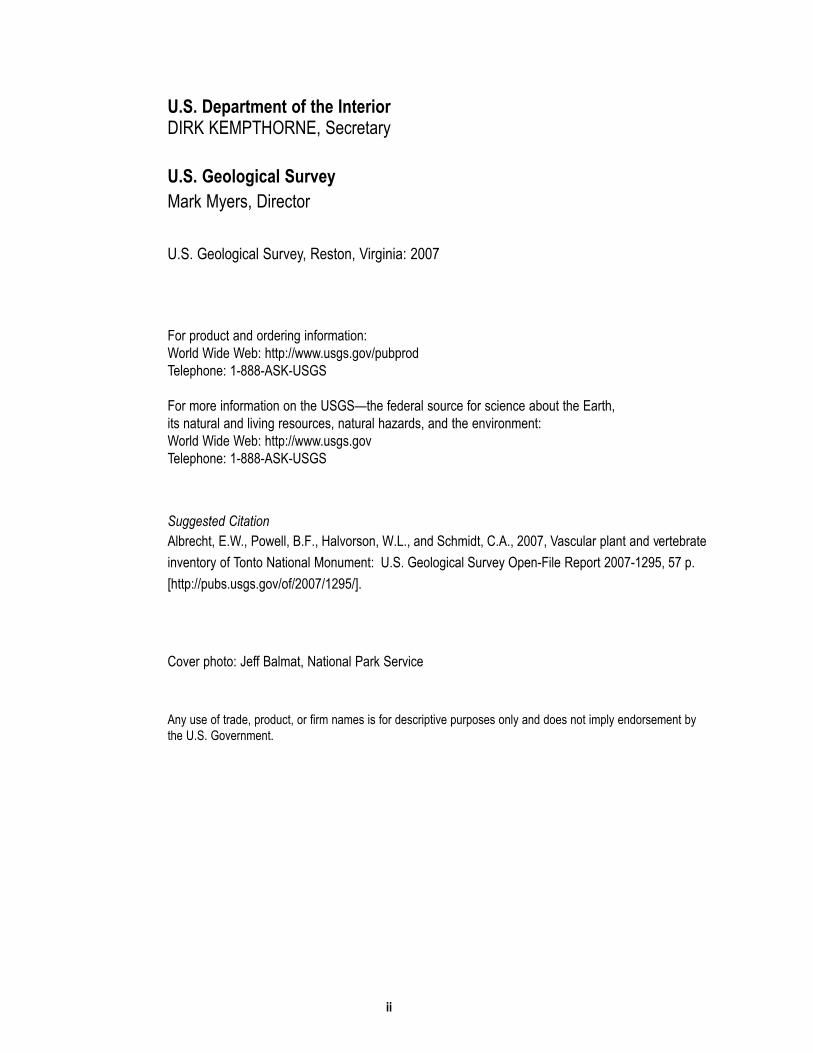
Figure 2.1. Cave Canyon watershed and stream system, AZ..................................................................................6
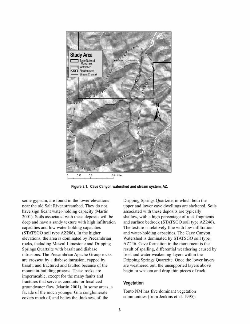
Figure 3.1. Location of general botanizing surveys, Tonto NM, 2001 and 2003. ................................................10
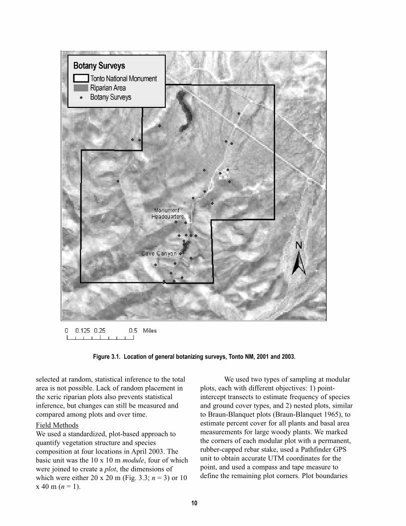
Figure 3.2. Location of modular plots for plants, Tonto NM, 2003......................................................................11
Figure 3.3. Modular plot arrangement of four 10 x 10 m modules, eight 1 x 1 m quadrats,
and four 10 m point-intercept transects, Tonto NM, 2003.. ...............................................................12
Figure 5.1. Location of diurnal survey stations for birds, Tonto NM, 2001–2003. ..............................................18
Figure 5.2. Location of nocturnal survey stations for birds, Tonto NM, 2001–2003. ..........................................20
Figure 6.1. Location of small mammal trapping plots, Tonto NM, 2001–2002. ..................................................30
List of Appendices
Appendix A. Plants observed (O) and collected (X) at Tonto NM. .....................................................................39
Appendix B. List of amphibians and reptiles found at Tonto NM by University of Arizona
inventory personnel and Swann et al. (SWN; 1996).......................................................................52
Appendix C. Bird species recorded by University of Arizona Inventory personnel (UA), Tonto
NM, 2001–2003 or that were reported in Hiett and Halvorson (H&H;1995). ...............................53
Appendix D. List of mammals observed at Tonto NM by University of Arizona Inventory
personnel (UA), Swann et al. (SWN;1996), and Bucci and Petryszyn (B&P;2004)......................57

viii

ix
Acknowledgements
Thanks to Shirley Hoh, park Superintendents Lee Baiza and Brad Traver, and all the staff at Tonto National
Monument (NM) for financial and logistical support. This project resulted from the collaboration of
National Park Service staff with many people at the University of Arizona (UA), and was facilitated by the
Desert Southwest Cooperative Ecosystem Studies Unit (CESU). Andy Hubbard and the Board of Directors
at the Sonoran Desert Network (SDN) Vital Signs Inventory and Monitoring (I&M) program, and Larry
Norris at the Desert Southwest CESU provided encouragement and support, and Matt Goode, Don Swann,
and Dale Turner provided early planning for this project. Eric Albrecht was an outstanding spokesperson
and leader of the program; he was an invaluable member of the team and his contributions are sorely
missed.
We thank a group of dedicated field biologists who collected data at Tonto NM for this project:
Greta Anderson, Sky Jacobs, James MacAdam, Meg Quinn, Patty West, and Emily Willard (plants); Dan
Bell, Kevin Bonine, James Borgmeyer, Dave Prival, and Mike Wall (amphibians and reptiles); Gavin
Beiber, Chris Kirkpatrick, and Gabe Martinez (birds); Melanie Bucci, Ryan Gann, Wendy Kramer, Neil
Perry, Jason Schmidt, and Ronnie Sidner (mammals). We are appreciative of the following people, many of
whom never ventured into the field, but whose office tasks made the field effort possible: Debbie Angell,
Pam Anning, Jennifer Brodsky, Lisa Carder, Brian Cornelius, Kathleen Docherty, Carianne Funicelli,
Colleen McClain, Heather McClaren, Lindsay Norpel, Jill Rubio, Brent Sigafus, Taffy Sterpka, Patina
Thompson, Jenny Treiber, and Alesha Williams. We thank Philip Guertin for his information on the Cave
Springs riparian area and watershed.
Additional administrative support was provided by Valery Catt at the U.S. Geological Survey,
Sonoran Desert Research Station and Terri Rice, Andy Honaman, Jenny Ferry, and especially Cecily
Westphal of the School of Natural Resources at the UA. Technical support was graciously given by the
following experts: Yar Petryszyn and Melanie Bucci of the UA Mammal Collection; Dan Austin, Michael
Chamberland, Phil Jenkins, and Charlotte and John Reeder at the UA Herbarium. Thanks to Peter
Wierenga, Sharon Megdal, and all the staff at the UA Water Resources Research Center, especially Terry
Sprouse and colleagues (Sprouse et al. 2002) for background information on Tonto NM. Phil Guertin
provided maps and information on hydrology and geology for this report.

x

xi
Executive Summary
This report summarizes the results of the first
biological inventory of plants and vertebrates at
Tonto National Monument (NM). From 2001 to
2003, we surveyed for vascular plants and
vertebrates (amphibians, reptiles, birds, and
mammals) at Tonto NM to record species
presence. We focused most of our efforts along
the Cave Springs riparian area, but surveyed other
areas as well. We recorded 149 species in the
riparian area, and 369 species overall in the
monument, including 65 plant species and four
bird species that were previously unrecorded for
the monument (Table 1). We recorded 78 plant
species in the riparian area that previous studies
had not indicated were present there.
Several species of each taxonomic group
were found only in the riparian area, suggesting
that because of their concentration in this small
area these populations are vulnerable to
disturbance and may be of management concern.
Four of the bird species that we recorded (Bell’s
vireo, yellow warbler, summer tanager, and
Abert’s towhee) have been identified as riparian
“obligate” species by other sources. Bird species
that are obligated to riparian areas are targets of
conservation concern due to widespread
degradation of riparian areas in the desert
southwest over the last century.
The flora and fauna of the riparian area
would benefit from continued limited public
access. The dependence of the riparian area on the
spring and surface flow suggests monitoring of this
resource per se would benefit management of the
riparian area’s flora and fauna as well. The
monument would benefit from incorporating
monitoring protocols developed by the Sonoran
Desert Network Inventory and Monitoring program
rather than initiating a separate program for the
riparian area. Park managers can encourage the
Inventory and Monitoring program to address the
unique monitoring challenges presented by small
spatial areas such as this riparian area, and can
request specific monitoring recommendations. We
suggest that repeat inventories for vertebrates, and
census (rather than sampling) of perennial
vegetation may be the most effective long-term
monitoring strategies in the riparian area to verify
species persistence through time in this unique and
spatially limited environment.
This report supersedes Albrecht et al.
(2005).
Table 1. Summary results of vascular plant and vertebrate inventories at Tonto NM, 2001–2003. Number of species Number of species Number of new species
Taxon group recorded in riparian area recorded in the monument added to monument lista
Plants 90 240 65
Amphibians and Reptiles 18 21 0
Birds 36 97 4
Mammals 5 11 0Totals 149 369 69
a Species that had not been observed or documented in previous studies.

xii

1
Chapter 1: Introduction to the Biological Inventories
Project Overview
Inventory: A point-in-time effort to document theresources present in an area. In the early 1990s, responding to criticism that it
lacked basic knowledge of natural resources
within park units, the National Park Service (NPS)
initiated the Inventory and Monitoring Program
(I&M; NPS 1992). The purpose of the program is
to detect long-term changes in biological
resources (NPS 1992). At the time of the
program’s inception, basic biological information,
including lists of plants and animals, was absent
or incomplete for many park units. In fact, as of
1994, more than 80% of national park units did
not have complete inventories of major taxonomic
groups (Stohlgren et al. 1995).
Species inventories have both direct and
indirect value for management of the monument
and are an important first step in long-term
monitoring. Species lists are not only useful in
resource interpretation and facilitating visitor
appreciation of natural resources, but are also
critical for making management decisions.
Knowledge of which species are present,
particularly sensitive species, and where they
occur provides for informed planning and
decision-making (e.g., locating new facilities).
Thorough biological inventories provide a basis
for choosing parameters to monitor and can
provide baseline data for monitoring ecological
populations and communities. Inventories can also
test sampling strategies, field methods, and data
collection protocols, and provide estimates of
variation that are essential in prospective power
analyses. In some cases, inventories may identify
or provide data related to critical resources such
as riparian areas that are valuable both
intrinsically and as habitat for species of
management interest.
Purpose and Goals
The purpose of this study was to complete basic
inventories for vascular plants and vertebrates at
Tonto NM. This effort was related to a larger
biological inventory of effort in eight NPS units in
southern Arizona and southwestern New Mexico
(Davis and Halvorson 2000; e.g., Powell et al.
2005), though separate funding was secured
from the monument to carry out this project. The
results presented in this report supersede those
reported by Powell et al. (2002, 2003) and Albrecht
et al. (2005).
The goals of our biological inventory of
Tonto NM were to:
1. Conduct field surveys to document at least
90% of all species of vascular plants and
vertebrates that occur within and near the
monument, with particular emphasis on the
riparian area near Cave Springs.
2. Use repeatable sampling designs and survey
methods (when appropriate) that allow
estimation of parameters of interest (e.g.,
relative abundance) with associated
estimates of precision.
3. Compile historic occurrence data for all
species of vascular plants and vertebrates
from three sources: museum records
(voucher specimens), previous studies, and
monument records.
4. Create resources useful to monument
managers, including detailed species lists,
maps of study sites, and high-quality digital
images for use in resource interpretation and
education.
The bulk of our effort addressed the first
two goals. To maximize efficiency (i.e., the number
of species recorded by effort) we used field
techniques designed to detect multiple species. We
did not undertake single-species surveys for
threatened or endangered species.
Report Format and Data Organization
This report is intended to be useful for internal
planning and outreach and education. We report
only common names unless we reference a species
that is not listed later in an appendix; in this case we
present both common and scientific names. For each
taxonomic group we include an appendix of all
species that we recorded in the monument
(Appendices A–D). Animal species lists are in
phylogenetic sequence and include taxonomic order,
family, genus, species, subspecies or variety (if

2
applicable) and common name. Scientific and
common names used throughout this document
are current according to accepted authorities for
each taxonomic group: Integrated Taxonomic
Information System (ITIS 2004) and the PLANTS
database (USDA 2004) for plants; Stebbins (2003)
for amphibians and reptiles; American
Ornithologists' Union (AOU 1998, 2003) for
birds; and Baker et al. (2003) for mammals. Units
of measurement are presented in accordance with
the International System of Units.
Spatial Data
Most spatial data are geographically referenced to
facilitate mapping of study plots and locations of
plants or animals. Coordinates were stored in the
Universal Transverse Mercator (UTM) projection
(Zone 12), using the North American Datum of
1983 (NAD 83). We recorded most UTM
coordinates using hand-held Garmin E-Map®
Global Positioning System (GPS) units (Garmin
International Incorporated, Olathe, KS; horizontal
accuracy about 10–30 m) because of their
convenience and relative simplicity. We obtained
some plot or station locations by using more
accurate Trimble Pathfinder® GPS units (Trimble
Navigation Limited, Sunnyvale, CA; horizontal
accuracy about 1 m). It should be noted that not
all UTM coordinates reported are accurate
representations of the plant or animal location. For
example, UTM coordinates associated with plot-
based detections are for the plot corners. Bird
sightings are an exception; the UTM coordinates
are reported for survey stations or transects, but
the animals we detected were typically up to 150
m distant (in rare cases as far away as 300 m). All
study-site coordinates are stored at the same
locations as for data archiving (below).
Databases and Data Archiving
We entered field data into taxon-specific databases
(Microsoft Access version 97) and checked all
data for transcription errors. From these databases
we reproduced copies of the original field
datasheets using the “Report” function in Access.
The output looks similar to the original datasheets
but data are easier to read. The databases, Access
datasheet printouts, and other data such as digital
photographs will be distributed to Special
Collections at the University of Arizona, Main
Library in Tucson.
Original copies of all datasheets are
currently housed at the NPS SDN I&M program
office in Tucson and may be archived at another
location. This redundancy in data archiving is to
ensure that these valuable data are never lost. Along
with the archived data we will include UTM
coordinates and copies of the original datasheets
with a guide to filling them out. This information, in
conjunction with the text of this report, should
enable future researchers to repeat our work.
Verification and Assessment of Results
Photograph Vouchers
Whenever possible we documented vertebrate
species with analog color photographs. Many of
these photographs show detail on coloration or other
characteristics of visual appearance, and they may
serve as educational tools for the monument staff
and visitors. We archived photographs with other
data (as described above) and provided the
monument with digital copies.
Voucher Specimens
With proper documentation, voucher specimens
become an indisputable form of evidence of a
species occurrence. For plants, we searched the
University of Arizona Herbarium for existing
specimens from Tonto NM (see Appendix A for
results).We also collected herbarium specimens
whenever flowers or fruit were present on plants in
the field. All specimens that we collected were
accessioned into the University of Arizona
Herbarium. We searched for existing vouchers from
Tonto NM in records from 23 natural history
museums (Table 1.1).

Table 1.1. Museums that were queried in 1998 for vertebrate voucher specimens with “Arizona” and “Tonto NationalMonument” in the collection location. Collection Collection cont.
Chicago Academy of Sciences Peabody Museum, Yale University
Cincinnati Museum of Natural History & Science Saguaro National Park
Cornell Vertebrate Collections, Cornell University Strecker Museum, Baylor University, Waco
George Mason University (Fairfax, VA) Texas Cooperative Wildlife Collection
Marjorie Barrick Museum, University of Nevada-Las Vegas University of Arizona
Michigan State University Museum (East Lansing) University of Texas, Arlington
Milwaukee Public Museum University of Illinois, Champaign-Urbana
Museum of Texas Tech University University of Colorado Museum
Museum of Vertebrate Zoology , University of California, Berkeley Walnut Canyon National Monument, Arizona
Museum of Life Sciences, Louisiana State University, Shreveport Western Archaeological and Conservation Center, Tucson
North Carolina State Museum of Natural Sciences Wupatki National Monument, Arizona
Oklahoma Museum of Natural History, Norman
3

4

5
Chapter 2: Introduction to Tonto National Monument
Monument OverviewTonto National Monument (NM) was established
by presidential proclamation in 1907 to protect
unique cliff dwellings and associated
archaeological sites. This 453-ha monument is
located in east-central Arizona, about 8 km south
of Roosevelt Dam near the shores of Theodore
Roosevelt Lake, a 7,015-ha reservoir. Monument
elevations range from 700 to 1200 meters. People
of the Salado culture inhabited the cliff dwellings
for approximately 300 years, abandoning the site
around 1450 AD. As many as 83,000 visitors tour
the monument each year (NPS 2003).
Climate
Measurements at a nearby weather station on the
edge of Roosevelt Lake indicate that average
temperatures at the lower elevations of Tonto NM
may vary from a minimum of 12.8°C to a
maximum of 27.2°C, with daily average high
temperatures above 40°C in summer and daily
average low temperatures slightly above freezing
in the winter (Table 1.1). The monument averages
40.6 cm of precipitation a year, approximately 55%
of which falls between November and March and
37% of which falls between July and October.
April, May, and June are dry months averaging
approximately 9% of the annual precipitation
(Table 2.1).
Based on Prism annual precipitation data
(NRCS 2004) there is an elevation influence on
precipitation distribution, with the lower elevations
receiving approximately 38 cm of annual
precipitation while the higher elevations of the
Cave Canyon Watershed receive approximately 50
cm of annual precipitation. Summer monsoon
precipitation is typically produced by convection
thunderstorms that are characterized by short
duration, high intensity rainfall. In Arizona’s
semiarid environments most of the runoff occurs
during the monsoon season (Renard 1970). Winter
precipitation is typically produced by frontal
systems that are characterized as longer-duration,
low-intensity rainfall that seeps into the soil and
produces less runoff. During monsoon
thunderstorms, locally heavy rains or longer-
lasting, widespread frontal weather systems can
cause sheet or flash flooding (Halvorson 2000).
Three times in the past ten years, significant
flooding has changed the configuration of the
stream in Cave Canyon.
Geology and Soils
Tonto NM is located in the Basin and Range
Physiographic Province. The northeastern one-third
of the monument is characterized by alluvial fans
and bajada slopes, which skirt the mountains. The
mountains drop down northward to the Salt River
valley floor. The monument is also characterized
by Precambrian rocks, whose origin began a little
more than one billion years ago with deposition of
Apache Group sediments. Uplift created basins and
mountains, and then erosion began filling those
basins with rock from the surrounding mountains.
This basin-fill was cemented in place, forming Gila
Conglomerate. Renewed uplift entrenched the
course of the Salt River, which downcut through
the conglomerate.
There are two primary geology formations
of hydrologic consequence in the Tonto area. The
northwest-southeast trending Two Bar Fault
delineates Tertiary sediments to the northwest, and
Precambrian sedimentary (and metasedimentary)
rocks of the Apache Group to the southeast (Martin
2001). The Tertiary alluvial sediments,
predominantly mudstone and fine-grain sand with
Table 2.1. Climate data from Roosevelt Lake weather station (675 m elevation), 1905 to 2003 (Western Regional ClimateCenter 2004).
CharacteristicMonth
AnnualJan Feb Mar Apr May Jun Jul Aug Sep Oct Nov Dec
Average max. temperature (°C) 15 18 21 26 31 37 39 37 35 28 21 15 27.0
Average min. temperature (°C) 3 4 7 10 15 20 24 22 20 13 7 3 13.0
Average total precipitation (cm) 4.8 4.6 4.6 1.8 0.8 0.8 3.6 5.1 3.3 3.0 3.3 5.1 40.6
6
some gypsum, are found in the lower elevations
near the old Salt River streambed. They do not
have significant water-holding capacity (Martin
2001). Soils associated with these deposits will be
deep and have a sandy texture with high infiltration
capacities and low water-holding capacities
(STATSGO soil type AZ286). In the higher
elevations, the area is dominated by Precambrian
rocks, including Mescal Limestone and Dripping
Springs Quartzite with basalt and diabase
intrusions. The Precambrian Apache Group rocks
are crosscut by a diabase intrusion, capped by
basalt, and fractured and faulted because of the
mountain-building process. These rocks are
impermeable, except for the many faults and
fractures that serve as conduits for localized
groundwater flow (Martin 2001). In some areas, a
facade of the much younger Gila conglomerate
covers much of, and belies the thickness of, the
Dripping Springs Quartzite, in which both the
upper and lower cave dwellings are sheltered. Soils
associated with these deposits are typically
shallow, with a high percentage of rock fragments
and surface bedrock (STATSGO soil type AZ246).
The texture is relatively fine with low infiltration
and water-holding capacities. The Cave Canyon
Watershed is dominated by STATSGO soil type
AZ246. Cave formation in the monument is the
result of spalling, differential weathering caused by
frost and water weakening layers within the
Dripping Springs Quartzite. Once the lower layers
are weathered out, the unsupported layers above
begin to weaken and drop thin pieces of rock.
Vegetation
Tonto NM has five dominant vegetation
communities (from Jenkins et al. 1995):
Figure 2.1. Cave Canyon watershed and stream system, AZ.

7
Interior southwestern riparian deciduous forest and
woodland dominated by Arizona sycamore,
Arizona walnut, blue wildrye and netleaf
hackberry. This vegetation community is the
most unique biological feature of the
monument and results from the spring in Cave
Canyon (Halvorson 2000); this community is
referred to as “the riparian area” in this report.
Sonoran riparian woodland dominated by jojoba,
velvet mesquite and catclaw acacia; this
community is referred to as “the xeric riparian
area” in this report.
Interior chaparral dominated by alderleaf mountain
mahogany, Sonoran scrub oak, desert
needlegrass, and crucifixion thorn.
Semi-desert grassland dominated by Emory’s
globemallow, brownplume wirelettuce, desert
needlegrass, Lehmann lovegrass, jojoba,
common sotol, broom snakeweed, and
sideoats grama.
Sonoran desertscrub dominated by jojoba, broom
snakeweed, Fremont’s desert-thorn, yellow
paloverde, goldenhills, Eastern Mojave
buckwheat, Parish’s threeawn, and Arizona
spike-moss.
Management Concerns
Riparian Vegetation
The small riparian area at Tonto NM is the most
important biological resource in the monument and
the preservation of that resource and its constituent
species are important management concerns. To put
this resource in a regional perspective, riparian
plant communities in the southwestern United
States account for less than 1% of the landscape
cover (Skagen et al. 1998), yet it is estimated that
greater than 50% of southwestern bird species
(Knopf and Samson 1994) and up to 80% of all
wildlife species in the southwest are dependant on
riparian areas (Chaney et al. 1990). Riparian areas
in arid regions support high bird species diversity
due to their structural and floristic diversity
(Thomas et al. 1979, Lee et al. 1989, Strong and
Bock 1990), which results in insects for foraging
and large trees for nesting (Powell and Steidl
2000). Riparian vegetation, such as that found at
Tonto NM, has been found to decrease levels of
heavy metals in water and soil, decrease water
temperatures, and provide a source of organic
matter for stabilization of stream banks (Karpiscak
et al. 2001, Karpiscak et al. 1996, Osborne and
Kovacic 1993).
Visitor Use
Annual visitor use at Tonto NM has increased from
7,005 in 1934 to over 60,000 today (NPS 2003).
On average, February and March have the highest
visitation (combined 14,045 in 2003) followed by
January and April (combined 12,804 in 2003) (NPS
2003). It is also in March and April that resident
and some neo-tropical migrant birds nest and raise
their first broods of the season (Hiett and
Halvorson 1999). The only access to the Upper
Cliff Dwellings is a trail that goes directly through
the Cave Canyon riparian area. Although access to
this trail is limited to guided tours, it is unknown
whether visitor and maintenance activities in the
area affect avian reproductive success or other
essential wildlife behavior in this area. Researchers
in other locations have found that continual
disturbances, even from nearby recreational hiking,
may cause some species to alter their activity and
feeding patterns, and may lead birds to abandon
their nests or fail to defend the nest against
predators (Hockin et al. 1992, Theobald et al.
1997). The presence of humans can alter activity
patterns of other wildlife as well, especially
medium- and large-sized mammals. Visitors may
also trample vegetation and increase soil erosion if
walking off-trail, and may introduce non-native
species by dispersing seed attached to clothing.
Adjacent Land Use
Grazing
Cattle have been excluded from the monument
since 1981 but grazing continues on surrounding
lands (managed by the U.S. Forest Service), most
notably in the headwaters of Cave Canyon. Cattle
grazing can cause loss of vegetative cover, soil
compaction, stream bank destabilization, increased
runoff and soil erosion (Wohl and Carline 1996).
Sedimentation of Cave Canyon during flood events
(such as in 2003) may be associated with erosion in
the surrounding uplands of the watershed.
Recreation
Tonto NM is located near the Roosevelt Lake
Recreation Area, which is managed by the U.S.
Forest Service. Recently, the Forest Service added

8
new recreation areas in close proximity to the
monument which include campgrounds, boat-
launch ramps, and parking areas. These facilities
may bring additional visitors to the monument.
Changing Fire Regimes
Due to grazing and the introduction of non-native
grasses, vegetation composition of the dominant
Sonoran desertscrub community at the monument
has changed dramatically; the current community
can provide fuel for higher-frequency fires that,
although typically of low-intensity, can be
detrimental to cacti (Jenkins et al. 1995).
Conversely, in the higher-elevation semidesert
grassland areas of the monument, fire suppression
will likely lead to invasion of woody shrubs, which
sustain less frequent but more intense fires than
were historically present in the area (Jenkins et al.
1995).
Previous Biological Inventories
Baseline inventories of the monument’s flora and
fauna are nearly complete. Previous inventories
recorded 297 plant species (Burgess 1965, Brian
1991, Phillips 1992, Jenkins et al. 1995, and
Phillips 1996), 229 vertebrate species (Swann et al.
1996, Hiett and Halvorson 1995) and over 340
invertebrate species (Price and Fondriest 1995).
Each of these efforts produced reports that included
species lists and summaries of prior research. We
summarize previous vertebrate and plant
inventories in appendices A-D and we refer the
reader there for additional details.
Plants
There have been two inventories of plants at the
monument (Burgess 1965, Jenkins et al. 1995) and
three additional studies of note: one that mapped
the distribution of 13 non-native species (Phillips
1992), one that investigated the effects of fire on
plants (Phillips 1996), and one that revisited line-
intercept plots after 25 years (Brian 1991). In
addition, there have been numerous specimen
collections, dating back to 1912. In addition to
producing the first and only vegetation map of the
monument, Jenkins et al. (1995) provided an
annotated plant list that included records from
previous studies and collections.
Birds
Hiett and Halvorson (1995) wrote an excellent
annotated species list for the monument in which
they reviewed prior studies and existing specimens,
and evaluated the seasonal status of 159 species.
These authors also wrote a bird-monitoring manual
for the monument and surveyed 10 stations during
the breeding season in 1994 and 1995 (Hiett and
Halvorson 1999). Unfortunately, field data from
that project have been lost (K. Hiett, pers. comm.).
Reptiles, Amphibians, and Mammals
Swann et al. (1996) inventoried for reptiles,
amphibians, and mammals at Tonto NM. Their
work included collection of field data and summary
of existing voucher specimens. They wrote
excellent annotated lists for species that had been
confirmed or were suspected to occur in the
monument. Melanie Bucci, a graduate student at
the University of Arizona School of Natural
Resources, surveyed for bats in the riparian area
and other locations in the monument from 2001 to
2003 (Bucci and Petryzsyn 2004).

9
Chapter 3: Plant Inventory
Introduction
Jenkins et al. (1995) reviewed previous vegetation
surveys at Tonto National Monument and presented
this summary with results from their own work. In
this document, we correct transcription errors and
update that review with records from Halvorson
and Guertin (2003) and our surveys (Appendix A).
This report builds on previous studies by adding
information on the distribution of plant resources,
particularly in the riparian area. We achieved this
by combining two different, yet complementary
approaches, described below.
Methods
Our surveys included both qualitative and
quantitative methods: qualitative “general
botanizing” surveys during which we
opportunistically collected and recorded plants in
the riparian area or over the remainder of the
monument, and quantitative “modular plot”
sampling in which we used two methods (point-
intercept transects and a form of Braun-Blanquet
plots) to estimate abundance, percent cover, and
species composition of all plants in a small area.
For all summary statistics in this report
(e.g., percentage of non-native species), we
excluded records that were not identified to species
unless there were no other specimens identified to
species for that genus (Appendix A). We recorded
11 species (and report records of 29 additional
species) with >2 subspecies and/or varieties
(Appendix A) and we included all subspecies
and/or varieties in our summary statistics of the
number of “species” recorded. We excluded
records that were not identified to species (n = 23;
e.g., Lotus spp.) in our work or that of previous
studies, unless there were no other records
identified to species for that genus (n = 3; e.g.,
Stipa spp.) (Appendix A).
Spatial Sampling Designs
General botanizing surveys were non-random and
were used to search intensively for species in the
riparian area or search extensively for species in
other areas of the monument. We located modular
plots by subjectively choosing areas that we felt
were representative of the mesic riparian area (two
plots) and xeric riparian area (two plots).
General Botanizing
Field Methods
We surveyed vegetation in 2001 and 2003 during
both spring and summer, and attempted to
document as many species as possible both in the
riparian area and across the monument as a whole
(Fig. 3.1). We collected one representative
specimen (with reproductive structures) for each
plant species (whenever possible), and maintained
a list of species observed but not collected (usually
because reproductive structures were not present).
These lists contribute to the “flora” for the
monument, and provide detailed information about
species present in the riparian area (Appendix A).
When we collected a specimen, we assigned it a
collection number and recorded the flower color,
associated dominant vegetation, date, collector
names, and UTM coordinates. We pressed and
processed the specimens on site, and after two to
three weeks froze them for 48 hours or more to
prevent infestation by insects and pathogens. We
accessioned mounted specimens to the herbarium
at the University of Arizona.
Effort
We completed general botanizing surveys at Tonto
NM on three days in July 2001, two days in March
2003, three days in April 2003, and two days in
May 2003.
Analysis
We listed all species that we recorded (Appendix
A).
Modular Plots
We completed modular plot work in cooperation
with the Sonoran Desert Network Vital Signs
Inventory and Monitoring program, which
developed the methods and protocol for use in
multiple National Park Service units. These data
also may serve as a baseline for monitoring
changes in the riparian area where survey effort
was high in proportion to total area covered by
mesic riparian vegetation; in fact, modular plots
covered >15% of the total area of the riparian area
(Fig. 3.2). However, because plots were not
10
Figure 3.1. Location of general botanizing surveys, Tonto NM, 2001 and 2003.
selected at random, statistical inference to the total
area is not possible. Lack of random placement in
the xeric riparian plots also prevents statistical
inference, but changes can still be measured and
compared among plots and over time.
Field Methods
We used a standardized, plot-based approach to
quantify vegetation structure and species
composition at four locations in April 2003. The
basic unit was the 10 x 10 m module, four of which
were joined to create a plot, the dimensions of
which were either 20 x 20 m (Fig. 3.3; n = 3) or 10
x 40 m (n = 1).
We used two types of sampling at modular
plots, each with different objectives: 1) point-
intercept transects to estimate frequency of species
and ground cover types, and 2) nested plots, similar
to Braun-Blanquet plots (Braun-Blanquet 1965), to
estimate percent cover for all plants and basal area
measurements for large woody plants. We marked
the corners of each modular plot with a permanent,
rubber-capped rebar stake, used a Pathfinder GPS
unit to obtain accurate UTM coordinates for the
point, and used a compass and tape measure to
define the remaining plot corners. Plot boundaries
11
were aligned in cardinal directions (e.g., the west
boundary was a north-south line).
Point-intercept Transects
We bisected each module with a north-south
transect (Fig. 3.3) that was measured using a 10-m
tape measure marked at 10-cm increments. In each
of three height categories (<0.5 m, 0.5–2 m and >2
m) we recorded the species of the first plant
intercepted by a vertical line every 10 cm along the
transect line (100 points per transect). We created
the vertical line with a laser pointer as often as
possible, and otherwise visually estimated its
position. If no plant was intercepted, we recorded
“no plant.” We classified ground cover at each
point according to the following categories: bare
soil, loose rock, bedrock, litter (senescent plant
material that was detached from plants).
Braun-Blanquet Plots
We used a form of the Braun-Blanquet method
(Braun-Blanquet 1965) to estimate percent cover
Figure 3.2. Location of modular plots, Tonto NM, 2003.

12
(spatial area of each plant species as viewed from
above) for each species on all modules and
quadrats (Fig. 3.3) in each of the height categories
used for point-intercept transects. We estimated
coverage at two scales: large (10 x 10 m; covering
the entire module; n = 4 per plot) and small (1 x 1
m quadrats at opposite corners of the module; n =
8 per plot) (Fig. 3.3).
To estimate percent cover by height
category for each plant species in the modules and
quadrats, we assigned the total coverage by each
species to one of six cover classes based on visual
estimation: “trace” (<1%), “1” (1–5%), “2”
(6–25%), “3” (26–50%), “4” (51–75%), or “5”
(76–100%). Because quadrats were nested within
modules (Fig. 3.1), modules always contained all
the plant species that were recorded in the
quadrats. We recorded tree species in each module
if the majority of the trunk was inside the module,
and recorded basal diameter if it was >15 cm. For
stems <15 cm basal diameter, we counted the
number of stems but did not record basal diameter.
Effort
We measured vegetation on two plots in the xeric
riparian area and on two plots in the mesic riparian
area at Tonto NM during three field days from 15
to 17 April 2003. Three plots had four modules in a
20 m x 20 m arrangement, and one plot had four
modules in a 10 m x 40 m arrangement.
Analysis
We report summary statistics for all plots.
Results
We observed or collected 240 species including 65
species that had not previously been found at the
monument (Appendix A). We also recorded: 142
species that had not been recorded in more than ten
years, 45 species not recorded in more than 30
years, five species not recorded in more than 60
years, and one species not recorded in more than
70 years.
General Botanizing
We recorded 181 species during general botanizing
surveys that we did not record during modular plot
Figure 3.3. Modular plot arrangement of four 10 x 10 m modules, eight 1 x 1 m quadrats, and four 10 m point-intercept transects, Tonto NM, 2003.

13
surveys. We recorded 54 species in the riparian
area.
Modular Plots
We recorded 34 species during modular plot
surveys that we did not record during general
botanizing surveys. We recorded 13 species in the
riparian area.
Discussion
The number of non-native plant species that we
recorded in the monument (n = 40, 16% of all
species we recorded) and in the riparian area
specifically (n = 14, also 16%) was somewhat
high. Grasses (Family Poaceae) accounted for one-
half of all non-native species in the monument (n =
20) and for one-half of all non-native species in the
riparian area (n = 7). In fact, more than half of the
grass species that we recorded in the riparian area
(n = 12) were non-native.
Some non-native plants alter ecosystem
function and processes (Naeem et al. 1996,
D’Antonio and Vitousek 1992), reduce abundance
of native species, and cause potentially permanent
changes in diversity and species composition
(Bock et al. 1986, D’Antonio and Vitousek 1992,
OTA 1993), but some species have stronger
impacts on the ecological community than others.
In assessing the potential threat posed by non-
native species, it is important to consider the
spatial extent of species, particularly those species
that have been identified as “invasive” or of
management concern. The extent of these species
may be more relevant than total number of non-
native species present, though such an investigation
was beyond the scope of this project.

14

15
Chapter 4: Reptiles and Amphibians Inventory
Introduction
Swann et al. (1996) completed a thorough
inventory of the amphibians and reptiles
(“herpetofauna”) of Tonto NM. Those authors also
reviewed previous records of herpetofauna species
at Tonto NM, and provided annotated species
accounts for all species that have been documented
at the monument; readers are referred to that
document for detailed information on all terrestrial
vertebrates of the monument. This document
updates their work and provides information
specific to the riparian area.
Methods
We surveyed for herpetofauna in 2001 and 2002
using non-plot-based methods because of our
limited time and our priority of detecting the
highest number of species possible. We considered
amphibians and reptiles together in this report
because we used the same search methods for both
groups. During our surveys for all taxonomic
groups (i.e., including observations from bird,
mammal, and plant survey crews), however, we
detected only one individual toad. We pooled
results from surveys in both years, and scaled total
number of individuals seen by search effort
(number of person-hours) to provide an index to
abundance for each species.
Field Methods
We used a type of visual encounter survey (Crump
and Scott 1994) to search for amphibians and
reptiles in areas that we felt would yield the most
species. Surveys were not constrained by area or
time. In general, we completed surveys during the
cooler morning and evening periods to maximize
our chances of encountering snakes and
amphibians that would be active during these times
(Ivanyi et al. 2000). Three crew members in 2001
and two in 2002 participated in these surveys. We
recorded weather information (temperature, relative
humidity, % cloud cover, wind speed, and an
overall description of the conditions) before and
after each survey. For each animal observed we
recorded species, sex and age class when this
information could be determined with certainty.
Effort
Two observers searched for amphibians and
reptiles in the riparian area at Tonto NM during
each of two visits: 17 and 18 September 2001 (total
of 20 person-hours) and 26 July 2002 (four person-
hours). During the 2002 visit, two observers also
searched the area between the Visitor Center and
the Lower Cliff Dwellings (five person-hours), and
a small area north of Route 88 (two person-hours),
which in some years supports a small pond that
provides breeding habitat for amphibians (Swann
et al. 1996). In this document, we report
“incidental sightings” of uncommon species made
by observers surveying for other taxonomic groups
(e.g., birds).
Analysis
We calculated the number of animals seen per
person-hour for each species during surveys in the
riparian area, and in all other areas of the
monument combined. We included incidental
observations from observers surveying for other
taxonomic groups. We considered species richness
to be the number of species observed in each area
by all observers and search methods. We did not
scale our estimate of richness by search effort as
we did with our index to abundance because
although number of individuals increases in a fairly
linear relationship to search effort, number of
species recorded quickly decreases after common
and conspicuous species are recorded. This pattern
results in shorter search periods often producing a
relatively higher number of (easily detected)
species compared with longer search times; simply
scaling number of species recorded by number of
search hours does not yield comparable results.
Incidental Observations
When observers surveying for taxonomic groups
other than herpetofauna encountered one of these
animals and could identify it definitively (e.g., Gila
monster, but not whiptail lizard species), they
recorded the species, sex and age class (if known),
time of observation, and UTM coordinates.

16
Results and Discussion
The herpetofauna crew recorded no amphibian
species and 12 reptile species during 31 person-
hours of searching in 2001 and 2002. Observers
surveying for other taxonomic groups recorded one
amphibian and an additional four reptile species
(Table 4.1). We did not add any species to the list
produced by Swann et al. (1996).
Species richness during the years of our
surveys was much higher in the riparian area (15
species during surveys, 18 species including
incidentals) than in other areas (four species during
surveys, seven species including incidentals),
though search effort was higher in the riparian
area. The relatively high number of reptile species
recorded in the riparian area is notable given its
small size and our limited search effort. After
accounting for differences in the amount of search
effort in the riparian area versus other locations in
the monument, we found two species that were
more commonly detected in the riparian area. We
recorded only the Sonoran coral snake and
Woodhouse’s toad outside of the riparian area.
Of the species that Swann et al. (1996)
reported as present either in the riparian area or in
all major vegetation types of the monument
(presumably including the riparian area), seven
were species we did not record. They also
concluded, based on 30 months of surveys, that
four species were associated only with the riparian
area and/or permanent water. Based on our findings
and those of Swann et al., there are at least 25
species of amphibians or reptiles that may occur in
the riparian area, and at least four of these are
obligated or are highly associated with riparian
areas.
Records of several rare species (e.g.,
western lyre snake) from observers who were
surveying for other taxonomic groups, illustrate the
opportunistic nature of such encounters. This
emphasizes the important contribution that all
researchers and trained staff can make in
documenting the persistence of species through
time.
Table 4.1. Number (n) and relative abundance of reptiles and amphibians recorded per person-hour of surveys at TontoNM, 2001 and 2002, and additional species recorded incidentally (X).
Species nYear
2001 2002 2003Woodhouse’s toad 1 Xwestern banded gecko 1 0.05greater earless lizard 3 0.15zebra-tailed lizard 1 0.25desert spiny lizard 1 0.25common side-blotched lizard 51 1.75 3.8ornate tree lizard 38 1.75 0.75Sonoran spotted whiptail 2 0.5western whiptail 31 0.4 5.6Madrean alligator lizard 1 0.05Gila monster X XSonoran whipsnake Xgopher snake 2 0.1common kingsnake Xwestern lyre snake XSonoran coral snake 1 0.25western diamond-backed rattlesnake 1 0.25black-tailed rattlesnake 1 X 0.25
17
Chapter 5: Bird Inventory
Introduction
Hiett and Halvorson (1995) produced a summary
of bird observations and specimen collections at
Tonto NM, which included observations made by
Hiett in 1993 and 1994 (Appendix C). Hiett and
Halvorson (1995) also summarize historical
observations.
We spent most of our field effort on bird
surveys in the riparian area. We surveyed the
riparian area for diurnal and nocturnal species
during three consecutive breeding seasons from
2001 to 2003 with the goal of recording as many
species as possible and determining indices of
relative abundance for the most common species.
By calculating relative abundance, this is the first
study at Tonto NM to standardize the collection of
bird data and provide estimates of abundance (see
Introduction chapter).
We established one survey transect in the
highest elevation area of the monument (uplands
transect) because this information provides a basis
for comparison with the riparian transect results,
and because no previous bird surveys had taken
place there. We suspected that this area might
provide habitat for birds not recorded in other areas
of the monument.
Methods
We surveyed for birds using three field methods:
variable circular-plot counts for diurnal breeding
birds, nocturnal surveys for nightjars (e.g.,
poorwills) and owls, and incidental observations
for all birds. We concentrated our survey effort
during the breeding season because bird
distribution is relatively uniform during that time
due to territoriality among birds (Bibby et al.
2002), which increases our precision in estimating
relative abundance, and enables us to document
breeding activity. It is important to note, however,
that our survey period included the peak spring
migration period for most species, which added
many passive migrant species to our list.
We also sampled vegetation around
breeding-bird survey stations along the riparian
transect because vegetation structure and plant
species composition are important predictors of
presence of particular species or of high species
richness (MacArthur and MacArthur 1961, Rice et
al. 1984, Strong and Bock 1990, Powell and Steidl
2000).
Spatial Sampling Design
All survey stations were subjectively located along
the road, riparian area, and uplands. Therefore, no
inference can be made to areas not surveyed;
however, our surveys provided complete coverage
of the riparian area.
Diurnal Surveys
Field Methods
We used the variable circular-plot method
(Reynolds et al. 1980) to survey for diurnally
active birds during the breeding season.
Conceptually, these surveys are similar to
traditional “point counts” (Ralph et. al 1995)
during which an observer spends a standardized
period of time at one location and records all birds
seen or heard. Variable circular-plot counts
incorporate estimation of distance to each bird or
group of birds, and this “distance sampling”
strategy facilitates accurate estimates of density
(Buckland et al. 1993). This survey method has
become the standard for many studies and
collecting data in this manner may facilitate
comparisons through time at this location, or
comparisons with other areas.
We established two transects at Tonto NM
(see “Effort” section below) (Fig 5.1). Stations
along each transect were located a minimum of 250
m apart to maintain spatial independence among
observations at different stations. Each year we
surveyed from April through July, the period of
peak breeding activity for most species in the area.
We maintained a minimum of ten days between
surveys. On each visit, we alternated observers and
alternated the order in which we surveyed stations
(along a transect) to minimize bias by observer,
time of day, and direction of travel. We began bird
surveys approximately 30 minutes before sunrise
and concluded no later than four hours after
sunrise, or when bird activity decreased markedly.
We did not survey during winds that exceeded 15
kph or when precipitation exceeded an intermittent
drizzle.

18
We recorded a number of environmental
variables at the beginning of each transect: wind
speed category (Beaufort scale), presence and
severity of rain (qualitative assessment), air
temperature (ºF), relative humidity (%), and cloud
cover (%). After arriving at a station, we waited
one minute before beginning the count to allow
birds to resume their normal activities. We
identified to species all birds seen or heard during
an eight-minute “active” survey period. For each
detection we recorded distance in meters from the
observer (measured with laser range finder when
possible), time of detection (measured in one-
minute intervals beginning at the start of the active
period), and the sex and/or age class (adult or
juvenile) if known. We did not measure distances
to birds that were flying overhead, nor did we use
techniques to attract birds (e.g., “pishing”). We
made an effort to avoid double-counting
individuals that had been recorded at previous
Figure 5.1. Location of diurnal survey stations for birds, Tonto NM, 2001–2003. Stations numbers 1–6 are the ripariantransect and the U1–U4 are the upland transect.

19
stations. If we recorded a species during the
“passive” count period, (between the eight-minute
counts) we considered it as an “incidental”
detection and recorded distance from the bird to the
nearest station. We recorded breeding behavior
when observed (see “Breeding Behavior” section
below).
Effort
The riparian transect (six stations) included most of
the length of Cave Canyon within monument
boundaries. One station was centered in the
riparian area, and the other five stations were
located in the xeric riparian area. We surveyed the
riparian transect 14 times from 2001 to 2003 (four
times in 2001 and five times each in 2002 and
2003). The four stations in the upland transect
(above the Upper Ruins) were in the Interior
Chaparral vegetation community, but included
components of the Semidesert Grassland
vegetation community (as delineated by Jenkins et
al. [1995]). We visited the uplands transect four
times in 2002 only.
Analysis
We calculated relative abundance of each bird
species (by transect and year) as the total number
of detections across all stations and visits divided
by effort (the number of stations multiplied by the
number of visits). We reduced our full collection of
observations (n = 1,313) to a subset of data (n =
712) by truncating all detections >75 m from each
station. Truncating observations increases the
validity of comparisons through space and time
because the probability of detection of species and
individuals is, in part, a function of the
conspicuousness of species; ranging from loud and
highly visible (e.g., Gila woodpecker) to quiet
(e.g., verdin) (Verner and Ritter 1983). We
excluded additional observations to further
standardize data for comparative purposes: birds
flying over the station (123 observations), birds
observed outside of the eight-minute count period
(141 observations), and unknown species (26
observations). Some observations met more than
one of these criteria.
Nocturnal Surveys
Field Methods
To survey for owls we broadcast commercially
available owl vocalizations (Colver et al. 1999)
using a compact disc player and broadcaster (Bibby
et al. 2002), and we recorded other nocturnal
species (nighthawks and poorwills) when observed.
We established one nocturnal survey transect along
the road and riparian area. The numbers of stations
varied from six in 2001 to three in 2002 and 2003.
All stations were a minimum of 300 m apart (Fig
5.2). As with other survey methods, we varied
observers and direction of travel along transects
and did not survey during periods of excessive rain
or wind. We began surveys 45 minutes after sunset.
At each station, we began with a three-
minute “passive” listening period during which we
did not broadcast calls. We then broadcast
recordings for a series of two-minute “active”
periods. We used recordings of species that we
thought, based on habitat requirements and
geographic range, might be present: elf owl,
western screech owl, and barn owl. We broadcast
recordings of owls in sequence from smallest to
largest-size species so that smaller species would
not be inhibited by the “presence” of larger
predators or competitors (Fuller and Mosher 1987).
During active periods, we broadcast owl calls for
30 seconds followed by a 30-second listening
period. This pattern was repeated two times for
each species. Though they were likely present, we
excluded great horned owl from the broadcast
sequence because of their aggressive behavior
toward other owls. We did not survey for species
listed as threatened or endangered (cactus-
ferruginous pygmy owls [Glaucidium brasilianumcactorum] or Mexican spotted owls [Strixoccidentalis lucida]) because precise protocols are
required by law for those species, and species-
specific surveys are generally an inefficient use of
inventory effort. However, monument personnel
surveyed for Mexican spotted owls during the time
of our study (S. Hoh, pers. comm.). During the count period we used a
flashlight to scan nearby vegetation for visual
detections. If we observed a bird during the three-
minute passive period, we recorded the minute in
which the bird was first observed, the type of
detection (aural, visual or both), and the distance to
the bird. If a bird was observed during any of the
two-minute active periods, we recorded in which
interval(s) it was detected and the type of detection
(aural, visual or both). As with other survey types
we attempted to avoid double-counting individuals
recorded at previous stations. We also used

20
multiple observers, alternated direction of travel,
and did not survey in inclement weather.
Effort
We established one transect along the road and
riparian area. In 2001, we surveyed at six stations
on three visits. In 2002 and 2003, we surveyed at
three stations for two and four visits, respectively.
Analysis
We used all detections of nocturnal species in our
analysis of relative abundance. When calculating
relative abundance, we used a sample size (n) of 36
(number of stations multiplied by number of
visits).
Incidental Observations
Field Methods
When we were not conducting formal surveys and
we encountered a species of interest (as determined
by the observer), a species in an unusual location,
or an individual displaying breeding behavior, we
recorded UTM coordinates, time of detection, and
(if known) the sex and age class of the bird. We
recorded all observations that confirmed breeding
Figure 5.2. Location of nocturnal survey stations for birds, Tonto NM, 2001–2003.

21
using a standardized classification system
(NAOAC 1990). We based confirmation on
observations of behavior or evidence that
conformed to at least one of nine categories: adult
carrying nesting material, nest building, adult
performing distraction display, used nest, fledged
young, occupied nest, adult carrying food, adult
feeding young, or adult carrying a fecal sac. We
also included incidental observations from
monument staff (Shirley Hoh) during the time of
the study
Analysis
We provide frequency counts for species observed
incidentally but did not calculate relative
abundance because it was not possible to quantify
survey effort for this method.
Vegetation Sampling at Diurnal Breeding-SeasonStations
We sampled vegetation near each diurnal survey
station to characterize vegetation. These data can
be used to help determine habitat associations for
specific bird species and to identify important
features of species-rich communities at the
monument. We sampled vegetation at five subplots
located at a modified random direction and
distance from each station. Each plot was located
within a 72° range of the compass from the station
(e.g., Plot 3 was located between 145° and 216°) to
reduce clustering of plots. We randomly placed
plots 0–75 m from the station to correspond with
truncation of data used in estimating relative
abundance. On rare occasions when plots
overlapped, we randomly selected another location
for the second plot.
At each plot we used the point-quarter
method (Krebs 1998) to sample vegetation by
dividing the plot into four quadrants along cardinal
directions. We applied this method to plants in four
size categories: sub-shrubs (0.5–1.0 m), shrubs
(>1.0–2.0 m), trees (>2.0 m), and potential cavity-
bearing vegetation (>20 cm diameter at breast
height [dbh]). If there was no vegetation for a
given category within 25 m, we indicated this in
the species column. For each individual plant, we
recorded distance from the plot center, species,
height, and maximum canopy diameter (excluding
errant branches). Association of a plant to a
quadrant was determined by the location of its
trunk, regardless of which quadrant the majority of
the plant was in; no plant was recorded in more
than one quadrant. Standing dead vegetation was
only recorded in the “potential cavity-bearing tree”
category.
We also visually estimated percent ground
cover, by type, at each plot: bare ground, litter, or
rock (loose rocks or stones). We estimated percent
aerial cover of vegetation, within a 5-m-radius
around the center of the plot, in each quadrant
using three height categories: <0.5 m, 0.5–2 m, and
>2 m. For each estimate we used one of six
categories for percent cover: “0” (0%), “1”
(1–20%), “2” (21–40%), “3” (41–60%), “4”
(61–80%), and “5” (81–100%).
Analysis
These data represent gross vegetation
characteristics around each survey station. In the
event that future bird surveys detect changes of
interest in ecological populations or communities,
the vegetation data reported in Tables 5.7 and 5.8
can form the basis for repeat vegetation
measurements which may provide potential
explanatory variables for analysis.
Results
We recorded 1,898 observations representing 97
species during the three-year study
(Appendix C). The most common diurnal species
were the Bell’s vireo and northern cardinal along
the riparian transect (Tables 5.1, 5.2) and the
canyon towhee along the upland transect (Table
5.1). The most common nocturnal species was the
elf owl (Table 5.4). We observed nineteen species
only once during the study, including the yellow-
headed blackbird, scarlet tanager, and yellow-
throated vireo.
Diurnal Surveys
Riparian Transect
We observed 71 species during diurnal surveys
along the riparian transect and calculated relative
abundance for 52 species (Table 5.1). We observed
26 species in all years and 18 species in only one
year. Bell’s vireo and northern cardinal were the
two most abundant species across all years. We
recorded only one individual for each of 12 species
(Tables 5.1, 5.2). Phainopepla abundance increased
between 2002 and 2003 (t = 2.0, P = 0.05) and
verdin abundance decreased between 2001 and
22
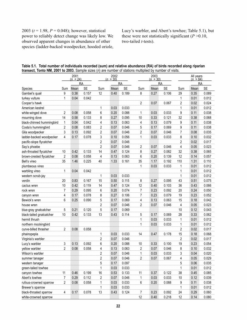
2003 (t = 1.98, P = 0.048); however, statistical
power to reliably detect change was likely low. We
observed apparent changes in abundance of other
species (ladder-backed woodpecker, hooded oriole,
Lucy’s warbler, and Abert’s towhee; Table 5.1), but
these were not statistically significant (P >0.10,
two-tailed t-tests).
Table 5.1. Total number of individuals recorded (sum) and relative abundance (RA) of birds recorded along ripariantransect, Tonto NM, 2001 to 2003. Sample sizes (n) are number of stations multiplied by number of visits.
2001 2002 2003 All years
Species
(n = 24) (n = 30) (n = 30) (n = 84)
Sum RA
Sum RAMean SE Sum
RASum
RAMean SE Mean SE Mean SE
Gambel’s quail 9 0.38 0.157 12 0.40 0.189 8 0.27 0.106 29 0.35 0.089turkey vulture 1 0.04 0.042 1 0.01 0.012Cooper’s hawk 2 0.07 0.067 2 0.02 0.024American kestrel 1 0.03 0.033 1 0.01 0.012white-winged dove 2 0.08 0.058 6 0.20 0.088 1 0.03 0.033 9 0.11 0.038mourning dove 14 0.58 0.133 8 0.27 0.095 10 0.33 0.121 32 0.38 0.068black-chinned hummingbird 1 0.04 0.042 4 0.13 0.063 4 0.13 0.079 9 0.11 0.038Costa’s hummingbird 2 0.08 0.083 2 0.07 0.046 5 0.17 0.069 9 0.11 0.038Gila woodpecker 3 0.13 0.092 2 0.07 0.046 2 0.07 0.046 7 0.08 0.035ladder-backed woodpecker 4 0.17 0.078 3 0.10 0.056 1 0.03 0.033 8 0.10 0.032pacific-slope flycatcher 2 0.07 0.046 2 0.02 0.017Say’s phoebe 2 0.07 0.046 2 0.07 0.046 4 0.05 0.023ash-throated flycatcher 10 0.42 0.133 14 0.47 0.124 8 0.27 0.082 32 0.38 0.065brown-crested flycatcher 2 0.08 0.058 4 0.13 0.063 6 0.20 0.139 12 0.14 0.057Bell’s vireo 35 1.46 0.225 40 1.33 0.161 35 1.17 0.192 110 1.31 0.110plumbeous vireo 1 0.03 0.033 1 0.01 0.012warbling vireo 1 0.04 0.042 1 0.01 0.012western scrub-jay 1 0.03 0.033 1 0.01 0.012verdin 20 0.83 0.167 15 0.50 0.115 8 0.27 0.095 43 0.51 0.075cactus wren 10 0.42 0.119 14 0.47 0.124 12 0.40 0.103 36 0.43 0.066rock wren 7 0.29 0.095 6 0.20 0.074 7 0.23 0.092 20 0.24 0.050canyon wren 4 0.17 0.078 8 0.27 0.106 7 0.23 0.079 19 0.23 0.052Bewick’s wren 6 0.25 0.090 5 0.17 0.069 4 0.13 0.063 15 0.18 0.042house wren 2 0.07 0.046 2 0.07 0.046 4 0.05 0.023blue-gray gnatcatcher 5 0.21 0.120 5 0.17 0.069 10 0.12 0.043black-tailed gnatcatcher 10 0.42 0.133 13 0.43 0.114 5 0.17 0.069 28 0.33 0.062hermit thrush 1 0.03 0.033 1 0.01 0.012northern mockingbird 1 0.03 0.033 1 0.01 0.012curve-billed thrasher 2 0.08 0.058 2 0.02 0.017phainopepla 1 0.03 0.033 14 0.47 0.178 15 0.18 0.068Virginia’s warbler 2 0.07 0.046 2 0.02 0.017Lucy’s warbler 3 0.13 0.092 6 0.20 0.088 10 0.33 0.100 19 0.23 0.054yellow warbler 2 0.08 0.058 4 0.13 0.063 2 0.07 0.046 8 0.10 0.032Wilson’s warbler 2 0.07 0.046 1 0.03 0.033 3 0.04 0.020summer tanager 2 0.07 0.046 2 0.07 0.067 4 0.05 0.029western tanager 5 0.17 0.097 5 0.06 0.035green-tailed towhee 1 0.03 0.033 1 0.01 0.012canyon towhee 11 0.46 0.199 16 0.53 0.133 11 0.37 0.122 38 0.45 0.085Abert’s towhee 7 0.29 0.112 2 0.07 0.046 1 0.03 0.033 10 0.12 0.039rufous-crowned sparrow 2 0.08 0.058 1 0.03 0.033 6 0.20 0.088 9 0.11 0.038Brewer’s sparrow 1 0.03 0.033 1 0.01 0.012black-throated sparrow 4 0.17 0.078 13 0.43 0.124 7 0.23 0.092 24 0.29 0.060white-crowned sparrow 12 0.40 0.218 12 0.14 0.080

23
2001 2002 2003 All years
Species Sum
(n = 24) (n = 30) (n = 30) (n = 84) RA
Sum RA
Sum RA
Sum RA
Mean SE Mean SE Mean SE Mean SE
northern cardinal 28 1.17 0.231 20 0.67 0.154 22 0.73 0.143 70 0.83 0.101black-headed grosbeak 1 0.03 0.033 1 0.01 0.012lazuli bunting 1 0.03 0.033 1 0.01 0.012indigo bunting 2 0.08 0.083 2 0.02 0.024brown-headed cowbird 8 0.27 0.106 9 0.30 0.167 17 0.20 0.071hooded oriole 7 0.29 0.112 9 0.30 0.109 4 0.13 0.063 20 0.24 0.055Scott’s oriole 1 0.03 0.033 1 0.01 0.012house finch 5 0.21 0.104 1 0.03 0.033 5 0.17 0.069 11 0.13 0.041lesser goldfinch 7 0.23 0.092 7 0.08 0.035Total number of detections 219 266 245 730Total number of species 30 42 37 52
Table 5.2. Number of observations at each station of the riparian transect, Tonto NM, 2001 to 2003. Stationnumber 4 was in the center of the riparian area south of the Visitor Center.
Station numberSpecies 1 2 3 4 5Gambel’s quail 6 4 6 4 1turkey vulture 1Cooper’s hawk 1American kestrel 1white-winged dove 1 1 1 1mourning dove 4 3 4 7 4black-chinned hummingbird 1 1 6Costa’s hummingbird 1 1 7Gila woodpecker 2 2 3ladder-backed woodpecker 3 1 2 2pacific-slope flycatcher 2Say’s phoebe 2 2ash-throated flycatcher 5 7 7 2 6brown-crested flycatcher 2 3 3Bell’s vireo 11 21 20 36 5 16plumbeous vireo 1warbling vireo 1western scrub-jay 1verdin 14 9 10 4 1cactus wren 5 8 13 1 6rock wren 2 3 9 6canyon wren 1 5 2 5 1Bewick’s wren 2 4 5 1house wren 1 1 1 1blue-gray gnatcatcher 2 1 2 2 1black-tailed gnatcatcher 7 3 5 1 5hermit thrush 1northern mockingbird 1curve-billed thrasher 1 1phainopepla 1 2 1 2Virginia’s warbler 1 1Lucy’s warbler 1 4 8 4 1yellow warbler 2 6Wilson’s warbler 2 1
64
58
22
4
53
5
5

24
Species
Station number
1 2 3 4 5 6
summer tanager 1 3western tanager 2 1 1green-tailed towhee 1canyon towhee 10 6 6 1 5 3Abert’s towhee 1 2 5 1 1rufous-crowned sparrow 6 3Brewer’s sparrow 1black-throated sparrow 7 4 1 2 7white-crowned sparrow 3 2 2northern cardinal 8 10 15 14 5 10black-headed grosbeak 1lazuli bunting 1indigo bunting 2brown-headed cowbird 1 1 3 2 1 4hooded oriole 2 5 6 4Scott’s oriole 1house finch 2 4 3 1 1lesser goldfinch 1 3 1 1
Table 5.3. Total number of individuals recorded (sum) and relative abundance of birds recorded along the uplandstransect (n = 15), Tonto NM, 2002.
Relative abundanceSpecies Sum Mean SE
mourning dove 1 0.07 0.067
olive-sided flycatcher 1 0.07 0.067
ash-throated flycatcher 2 0.13 0.091
gray vireo 2 0.13 0.091
western scrub-jay 2 0.13 0.091
cactus wren 6 0.40 0.131
rock wren 4 0.27 0.153
canyon wren 1 0.07 0.067
black-tailed gnatcatcher 4 0.27 0.153
northern mockingbird 1 0.07 0.067
Townsend’s warbler 2 0.13 0.133
western tanager 2 0.13 0.091
canyon towhee 8 0.53 0.215
rufous-crowned sparrow 5 0.33 0.159black-throated sparrow 6 0.40 0.163
Table 5.4. Relative abundance of nocturnal birds recorded along the owl transect (n = 36), Tonto NM, 2002. See Methodsfor details on estimation of relative abundance and effort.
Relative abundanceSpecies Sum Mean SE
barn owl 1 0.03 0.028
western screech-owl 1 0.03 0.028
great horned owl 1 0.03 0.028
elf owl 50 1.39 0.161common poorwill 15 0.42 0.140

25
Upland transect
We recorded 33 species during diurnal surveys
along the upland transect in 2002, and we
calculated relative abundance for 15 species (Table
5.3). The canyon towhee was the most abundant
species, and the cactus wren and black-throated
sparrow were also common. We recorded three
species in the upland transect that we did not find
in the riparian transect: olive-sided flycatcher, gray
vireo, and Townsend’s warbler. Although we did
not observe breeding behavior for the gray vireo,
our consistent observations of a singing male
throughout the survey period indicated that this
species likely nested in the upland area.
Nocturnal Surveys
We recorded five species of nocturnal birds (four
owls and one common poorwill) during nocturnal
surveys from 2001 to 2003 (Table 5.4). Of the four
species of owls that we detected, the elf owl was
the most abundant and was the only species that we
recorded more than once. Although the elf owl
appears to be the most abundant of all species in all
survey types (Tables 5.1, 5.2, 5.4), this is because
we did not truncate observations for nocturnal
species as we did for diurnal species, resulting in
differing (and incomparable) effective search areas.
Abundance of elf owls appears to have been
consistent across the three years of this study (1.3
to 1.5 detections per station-visit; Table 5.4).
Incidental Observations
Inventory staff recorded 12 species only on
incidental surveys and monument staff added an
additional two species. The number of individuals
detected for each of these species was low (n ≤ 2
for 11 species, and four yellow-eyed juncos in one
group), indicating that they are simply uncommon.
The addition of 14 species outside of formal
surveys (accounting for almost 15% of all species
recorded in 3 years) highlights the importance of
using this method in completing the inventory.
Breeding Observations
We recorded 57 observations of breeding behavior
(including 26 nest records) in 29 species from 2001
to 2003 (Table 5.5). We recorded the highest
number of breeding observations for the Bell’s
vireo (n = 11). Perhaps the most notable
observation was for the turkey vulture for which
we found a nest in a cave in the southwest portion
of the monument.
Vegetation
Bare ground was the most frequently occurring
cover-type near most stations (Table 5.6). As might
be expected, vegetation volume at all stations was
higher in the understory (<0.5 m height category)
than in the overstory (>2.0 m). Some stations,
however, had noticeably lower vegetation volume
in the overstory (stations 1 and 5) than did others,
indicating a lack of trees in the vicinity (Table 5.6).
The number of tree species in the overstory around
stations ranged from five (station 1) to ten (station
3) (Table 5.7). Using the “potential cavity nesting”
category to indicate presence of large trees (>20
cm dbh [diameter at breast height]), only station 4
had large Arizona sycamore and Arizona black
walnut trees (Table 5.7), which are characteristic
riparian vegetation.
Discussion
Our study was the first to use standardized
protocols to inventory birds at Tonto NM. We
focused most of our effort on the riparian area and,
as a result, these data can be used to compare
species richness and (in some cases) relative
abundance of species through time in that area.
We found high species turnover among
years in the riparian area (Tables 5.1, 5.2), which
points to the importance of completing surveys in
more than one year. In addition, we found several
species that are considered riparian obligates,
including Bell’s vireo, yellow warbler, summer
tanager, and Abert’s towhee (Rosenberg et al.
1991). Among these, the Bell’s vireo was the most
abundant species along the riparian transect, and
we were able to document breeding for this species
on numerous occasions (Table 5.5). Although we
did not document breeding by yellow warbler,
summer tanager, or Abert’s towhee, these species
are less common and less conspicuous than the
Bell’s vireo, and (based on consistent presence of
singing males) they likely nested in the monument.
These three species were more abundant at station
4 (in the center of the riparian area) than at all
other stations combined (Table 5.2).
The mesic riparian vegetation around
station number 4 of the riparian transect clearly
plays an important role in the bird community in

26
Table 5.5. Observations of breeding activity by birds, Tonto NM, 2001–2003. Breeding codes follow standards set by NAOAC(1990).
Bird AdultsAdults seen feeding Total
Nest Nest Adults seen carrying Recently recently numberNest with with on carrying nesting fledged fledged Distraction of
Species building eggs young nest food material young young display observationsGambel’s quail 1 1turkey vulture 1 1Cooper’s hawk 1 2 3mourning dove 3 3common poorwill 1 1white-throated swift 1 1black-chinned hummingbird 1 1 2 4Costa’s hummingbird 1 1Gila woodpecker 1 1ladder-backed woodpecker 1 1Say’s phoebe 1 1 2ash-throated flycatcher 1 1 2brown-crested flycatcher 1 1Bell’s vireo 4 1 2 1 1 9verdin 1 1 2bushtit 1 1 2rock wren 1 1canyon wren 1 1 2blue-gray gnatcatcher 1 1black-tailed gnatcatcher 1 1 1 3curve-billed thrasher 1 1phainopepla 1 1Lucy’s warbler 1 1 2canyon towhee 2 1 3rufous-crowned sparrow 1 1black-throated sparrow 1 1 2northern cardinal 1 1 1 3hooded oriole 3 3Total number of observations by category 10 2 4 11 7 5 12 6 1 30
that area. In general, birds are strongly influenced
by plant species and because trees such as Arizona
sycamore and netleaf hackberry are rare in the
southwest, these resources can play a key role in
determining which species nest in and around an
area (Bock and Bock 1984, Powell and Steidl
2000). These trees, with their large volume and
structure, provide more places for foraging and
nesting than do other tree species in this region
(Bock and Bock 1984). Although this study was
not designed to investigate characteristics of nest
habitat by individual species, it is important to note
that hooded oriole and Cooper’s hawk nested only
in the sycamore trees (near station number 4) and
that Bell’s vireos consistently nested in netleaf
hackberry along the riparian corridor (E. Albrecht,
pers. obs.). Similar patterns for Bell’s vireo and
hooded orioles were found by Powell and Steidl
(2000) in southern Arizona.
Although we documented an apparent
decline in abundance of verdin, we do not suggest
that these differences should be cause for concern;
the verdin is a common species of the Sonoran
riparian woodland and desertscrub, and short-term
fluctuations in population size are to be expected.
We recorded presence of four species that
had not been previously recorded at Tonto NM
(Hiett and Halvorson 1995, 1999): bushtit, black-
chinned sparrow, yellow-eyed junco, and yellow-
breasted chat. Among these, we found evidence of

27
Table 5.6. Summary of vegetation volume and percent ground cover near stations of the riparian transect, Tonto NM,2002.
Station
Percent vegetation volume
SE
Percent ground cover <0.5 m 0.5-2.0m
Mean SE >2.0 m Litter Bare ground
Mean SE Rock
Mean SE Mean Mean SE Mean SE1 14 3.7 12 3.0 5 1.7 8 2.0 65 6.0 28 5.02 24 5.2 23 4.2 14 4.1 17 4.0 57 5.9 30 5.03 38 7.1 29 5.8 13 4.9 35 6.5 51 8.2 13 3.44 43 5.1 21 2.9 15 6.7 28 6.6 36 4.7 39 4.65 37 4.4 9 1.4 1 0.7 15 2.1 42 4.4 49 4.56 32 5.2 25 5.6 14 5.4 21 3.2 39 3.4 44 5.3
Table 5.7. Summary of number of individual plants in the vicinity of riparian transect stations, Tonto NM, 2002.“Category” relates to the criteria outlined in the Methods section.
Category Scientific name Species Station
1 2 3 4 5>2.0 m Acacia constricta white-thorn acacia 1 1
Acacia greggii catclaw acacia 2 1 4 1 3Agave sp. Agave species 1Bacaris sarothroides desert broom 1Canotia holacantha crucifixion thorn 1 1 1Carnegia gigantus saguaro 1 1 2 3Celtis laevigata var. reticulata netleaf hackberry 3 3Parkinsonia florida blue paloverde 7 8 1 1Parkinsonia microphylla little leaf paloverde 7 5 2Dodonaea viscosa Florida hopbush 1Fouqieria splendens ocotillo 1 1 1 2Juglans major Arizona black walnut 2Juniperus monosperma one seed juniper 1 2 2Prosopis velutina velvet mesquite 3 4 6 8 7Simmondsia chinensis jojoba 1Yucca sp. Yucca species 2Ziziphus obtusifolia greythorn 1
Potential cavity- Carnegia gigantus saguaro 19 20 17 8 20 14bearing trees Juglans major Arizona black walnut 4
Platinus wrightii Arizona sycamore 3Prosopis velutina velvet mesquite 1 1
6
5
2
6
nesting for the bushtit (Table 5.5) and a crew
member recorded a singing male yellow-breasted
chat in 2002 in the dense mesquite patch north of
Highway 188, west of the monument entrance
road. It is possible that the bird nested in that area.
It is unlikely that bushtit and black-chinned
sparrow are recent arrivals to the monument;
Interior Chaparral, a vegetation type that these
species are often associated with, was mapped by
Jenkins et al. (1995). We also recorded the
presence of at least one singing male gray vireo
(another species commonly associated with Interior
Chaparral) throughout the 2002 breeding season.
Hiett and Halvorson (1995) suggested removing
the gray vireo from the monument list, but the
absence of these Interior Chaparral-associated
species from the monument species list was likely
a result of incomplete surveys; Interior Chaparral
occurs only at the highest elevation in the
monument, where Hiett did not survey (Hiett and
Halvorson 1995).
Two additional new species for the
monument, yellow-headed blackbird and scarlet
tanager, were seen by Shirley Hoh, Tonto NM
Resource Manager. These observations also
highlight the importance of continued reliable (and,
ideally, verifiable) observations by monument staff

28
and visitors to develop the most complete bird
species list.
Cavity-nesting Species
The elf owl was the most abundant nocturnal
species during our surveys (Table 5.4). Elf owls
prefer to nest in saguaros (Hardy and Morrison
2001) and the decline in the number of saguaros in
the monument due to of altered fire regimes and an
increase in spatial extent of non-native species
(Phillips 1996) could mean that abundance of this
species will also decline, or perhaps already has.
Other cavity-nesting species that may be affected
include: American kestrel, Gila woodpecker, and
ash-throated and brown-crested flycatchers.

29
Chapter 6: Mammal Inventory
Introduction
A thorough inventory of terrestrial mammals at
Tonto NM (including the riparian area) was
completed by Don Swann and colleagues between
1993 and 1995 (Swann et al. 1996). These authors
reviewed historical records for all mammals,
including bats, and provided species accounts for
all species that have been recorded at the
monument; readers are referred to that document
for detailed information.
We trapped nocturnal rodents to provide
recent information on this group of animals
(specifically in the riparian area), and we recorded
incidental observations of all mammal species. We
have included reports of species from other
research projects since the Swann et al. inventory
(1996) to update that work and indicate which
species are still present. We also provide a list of
bat species reported by Melanie Bucci, a graduate
student at the University of Arizona who trapped
bats at the monument from 2001 to 2003 (Bucci
and Petryszyn 2004).
Methods
We surveyed for mammals using three field
methods: trapping for small, terrestrial nocturnal
mammals (primarily rodents, herein referred to as
small mammals), investigation of roost sites and
trapping for bats, and incidental observations for
all mammals.
Spatial Sampling Design
We subjectively placed grids or groupings of small
mammal traps in or adjacent to the riparian area.
This non-random placement eliminates the
possibility of inference of our results to a larger
area, but we often achieved complete trap coverage
for the entire riparian area. We searched for bats
and bat sign at both the Upper and Lower Ruins
sites, and subjectively chose locations in the
riparian area for netting.
Small Mammals
Field Methods
We trapped small mammals in 2001 and 2002 in
and adjacent to the riparian area (Fig. 6.1). We
used Sherman® live traps (folding aluminum or
folding steel, 3 x 3.5 x 9”; H. B. Sherman, Inc.,
Tallahassee, FL) in grids (White et al. 1983) or
placed preferentially in groupings, with 10- to
20-m spacing among traps. We opened and baited
traps in the evening then checked and closed each
trap the following morning. For bait, we used one
teaspoon of a mixture that was 16 parts dry
oatmeal to one part peanut butter. We placed a
small amount of polyester batting in each trap to
prevent mortality from the cold. We marked each
captured animal with a semi-permanent marker to
enable us to identify previously captured animals if
they were recaptured; these “batch marks”
appeared to last for the duration of the sample
period (two to three nights). For each captured
animal, we recorded species, sex, age class (adult,
subadult, or juvenile), reproductive condition,
weight, and measurements for right hindfoot, tail,
ear, and head and body. For males, we recorded
reproductive condition as either scrotal or non-
reproductive. For females we recorded
reproductive condition as one or more of the
following: non-reproducing, open pubis, closed
pubis, enlarged nipples, small or non-present
nipples, lactating, post lactating, or not lactating.
Effort
In October 2001, we set single traps for two nights
at stations placed preferentially along the entire
stretch of riparian area (n = 60 stations with 5 –15
m spacing between traps), and set traps placed in
two grids (n = 48 stations in two 10 x 2
arrangements, with 12.5 m spacing among traps) in
adjacent upland sites. In September 2002, we set
single traps for one night and double traps (two
traps per station) for two nights in the riparian area
in two grids (n = 34 stations in one 12 x 2
arrangement and one 5 x 2 arrangement, with 15 m
among traps). In September 2002 we set single
traps for one night at two clusters of stations (n =
10 stations in two 10-m-diameter clusters of 5
stations each) in adjacent upland sites.
In summary, we sampled for nocturnal
rodents in fall of 2001 and 2002 using 290 trap-
nights on three plots in the riparian area and 106
trap nights on four plots in adjacent upland areas.

30
Analysis
We calculated relative abundance for each species
by dividing the number of captures by the number
of trap nights (number of traps multiplied by
number of nights they were open) after accounting
for sprung traps (Beauvais and Buskirk 1999).
Sprung traps are those that either misfired (n = 22)
or were occupied. Sprung traps reduce trap effort
because they are no longer “available” to capture
animals; we account for this by multiplying the
number of sprung traps by 0.5 (lacking specific
information, we estimate sprung traps were
available for half of the night) (Nelson and Clark
1973). After scaling results by trap effort, we
pooled results from multiple plots in the same year
for riparian and uplands areas; we did not have >2
plots for either category in either year.
Medium and Large-sized Mammals
As with other taxa, we recorded UTM coordinates
of mammal sightings. Observers from all field
crews (e.g., bird crew as well as mammal crew)
Figure 6.1. Location of small mammal trapping plots, Tonto NM, 2001–2002.
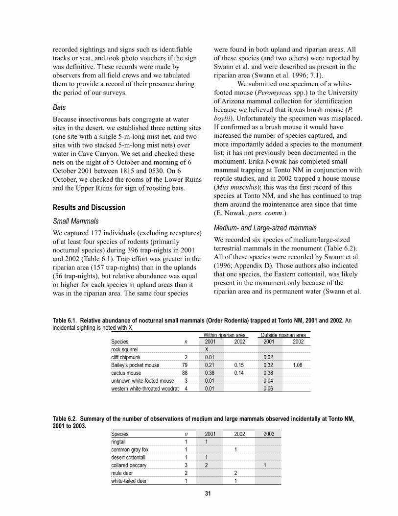
31
recorded sightings and signs such as identifiable
tracks or scat, and took photo vouchers if the sign
was definitive. These records were made by
observers from all field crews and we tabulated
them to provide a record of their presence during
the period of our surveys.
Bats
Because insectivorous bats congregate at water
sites in the desert, we established three netting sites
(one site with a single 5-m-long mist net, and two
sites with two stacked 5-m-long mist nets) over
water in Cave Canyon. We set and checked these
nets on the night of 5 October and morning of 6
October 2001 between 1815 and 0530. On 6
October, we checked the rooms of the Lower Ruins
and the Upper Ruins for sign of roosting bats.
Results and Discussion
Small Mammals
We captured 177 individuals (excluding recaptures)
of at least four species of rodents (primarily
nocturnal species) during 396 trap-nights in 2001
and 2002 (Table 6.1). Trap effort was greater in the
riparian area (157 trap-nights) than in the uplands
(56 trap-nights), but relative abundance was equal
or higher for each species in upland areas than it
was in the riparian area. The same four species
were found in both upland and riparian areas. All
of these species (and two others) were reported by
Swann et al. and were described as present in the
riparian area (Swann et al. 1996; 7.1).
We submitted one specimen of a white-
footed mouse (Peromyscus spp.) to the University
of Arizona mammal collection for identification
because we believed that it was brush mouse (P.boylii). Unfortunately the specimen was misplaced.
If confirmed as a brush mouse it would have
increased the number of species captured, and
more importantly added a species to the monument
list; it has not previously been documented in the
monument. Erika Nowak has completed small
mammal trapping at Tonto NM in conjunction with
reptile studies, and in 2002 trapped a house mouse
(Mus musculus); this was the first record of this
species at Tonto NM, and she has continued to trap
them around the maintenance area since that time
(E. Nowak, pers. comm.).
Medium- and Large-sized mammals
We recorded six species of medium/large-sized
terrestrial mammals in the monument (Table 6.2).
All of these species were recorded by Swann et al.
(1996; Appendix D). Those authors also indicated
that one species, the Eastern cottontail, was likely
present in the monument only because of the
riparian area and its permanent water (Swann et al.
Table 6.1. Relative abundance of nocturnal small mammals (Order Rodentia) trapped at Tonto NM, 2001 and 2002. Anincidental sighting is noted with X.
Within riparian area Outside riparian area Species n 2001 2002 2001 2002rock squirrel Xcliff chipmunk 2 0.01 0.02Bailey’s pocket mouse 79 0.21 0.15 0.32 1.08cactus mouse 88 0.38 0.14 0.38unknown white-footed mouse 3 0.01 0.04western white-throated woodrat 4 0.01 0.06
Table 6.2. Summary of the number of observations of medium and large mammals observed incidentally at Tonto NM,2001 to 2003.
Species n 2001 2002 2003ringtail 1 1common gray fox 1 1desert cottontail 1 1collared peccary 3 2 1mule deer 2 2white-tailed deer 1 1

32
1996). Although we did not observe any non-native
mammals, Swann et al. reported seeing a feral cat,
and also noted that reports of this species in the
monument date back to 1948 (Swann et al. 1996).
Bats
We did not capture any bats at Cave Canyon, and
found only minor accumulations of guano on the
floor of two main rooms in the Lower Ruins. We
were unable to determine from the guano which
species of bats were using the area. Bucci and
Petryszyn (2004) documented several species of
bats in the riparian area and other locations since
the report by Swann et al. (1996) was prepared,
and readers are referred to her reports for details; a
species list is presented in Appendix D.

33
Chapter 7: Conclusions and Implications
No species list is ever truly complete; species
distributions expand and contract, particularly in
locations as small as the riparian area in Cave
Canyon, but even in management areas the size of
Tonto NM. In addition, many inconspicuous
species are difficult to detect, as exemplified by the
desert night lizard (Xantusia vigilis),which was
recorded only once during the extensive study
conducted by Swann, et al. (1996) at Tonto NM; a
single juvenile was captured in the men’s room of
the visitor center by a seasonal maintenance
employee (Swann et al. 1996). Rare communities
such as the riparian area at Tonto are also used
periodically as “stopover habitat” by a number of
regionally rare bird species such as the yellow-
throated vireo and scarlet tanager. Despite the
relatively large amount of effort that has been
invested in biological inventories at Tonto NM
compared with other national park areas in the
region, our effort recorded species that others had
not — as, no doubt, will future studies. To continue
developing the list of species that occur at the
monument, it is important that all researchers be
encouraged to report reliable or (preferably)
verifiable sightings to natural resource staff.
Biological inventories are a point-in-time
effort, and although we did not observe and record
all species present in the riparian area during the
time of the inventory, we feel that the inventories
in the monument have now recorded at least ninety
percent of species that regularly occur in the
monument, including the riparian area (annual
plant species may be an exception). Our effort
established that this ecological community hosts a
portion of the monument’s natural resources that is
disproportionate to its small size.
These resources, however, include some
non-native species. Awareness of non-native
species as a management issue has risen
dramatically in recent years; ecologists have ranked
the issue with habitat loss as one of the most
significant causes of species endangerment (Brooks
and Pyke 2001). Although we did not record non-
native vertebrate species in the monument, Nowak
has trapped house mouse consistently since 2002
(E. Nowak, pers. comm.) and Swann et al. (1996)
reported observing a feral cat. Neither of these
species has been reported from the riparian area,
but it is likely for either to occur there. More
remarkable than the presence of these species is the
absence of additional non-native species; there are
no records of house sparrow (Passer domesticus)
or brown-headed cowbird (Molothrus ater), or of
the riparian-associated bullfrog (Rana catesbiana).
Non-native plant species are more prevalent; 40
species are known to occur in the monument
(Appendix A). Although some of these plants (e.g.,
some non-native lovegrasses) are known to
displace native vegetation, vertebrates, and
invertebrates in some environments (Bock et al.
1986), others are not as well studied. It is
especially important that the monument track the
presence and extent of non-native plant species
through time, particularly in the riparian area.
Future efforts that document presence of species
within the monument would benefit from having
spatially referenced data so that presence can be
attributed to areas of present or future management
interest (e.g., the riparian area).
Our surveys were meant to complement
existing research, particularly that done for plants,
herpetofauna, and mammals, and to establish
species presence in the riparian area. We put
considerably more effort into the bird inventory, in
part to compensate for the loss of data that was
collected by Hiett. As such, our bird inventory
could be considered a baseline for monitoring
avian resources at Tonto NM. There is a unique
opportunity, however, to repeat (in precise detail)
the work by Swann et al. (1996) and evaluate the
use of repeat inventories as a monitoring tool. Such
an effort is clearly beyond the scope of this project,
but would be unprecedented and would be useful to
the developing National Park Service (NPS) Vital
Signs monitoring program and other monitoring
efforts.
Biological Management Implications
We recommend that Tonto NM resource
management staff coordinate all monitoring
activities, including those specific to the riparian
area, with efforts of the NPS Sonoran Desert
Network Vital Signs Inventory and Monitoring
Program. Data that we collected at Tonto NM are
being used in development of that program. If
monument staff desires more intensive monitoring

34
in the riparian area than in other areas of the
monument, we recommend increasing the
frequency or intensity of Vital Signs monitoring
protocols for that area. It is inadvisable to maintain
multiple monitoring programs at a single land
management unit, because this strategy produces
incompatible data and is at minimum an inefficient
use of resources. Another data management issue
that needs to be addressed is paper and electronic
copies of raw data from both monitoring and
research activities. Archiving of these data by the
NPS will reduce the likelihood of the irreplaceable
information being lost
We anticipate that the Sonoran Desert
Network Vital Signs program will provide protocol
recommendations for biological monitoring in
small areas such as this, but it is advisable for
monument staff to encourage development of those
recommendations while the Vital Signs program is
still in the development phase.
Ultimately, managers should realize that
small areas such as the riparian area at Tonto NM
(approximately 200m by 20m) present unique
challenges to resource monitoring. Wide-ranging
species such as birds and many larger-bodied
reptiles and mammals require larger study areas to
provide space for multiple (spatially independent)
sampling units. Multiple sampling units (and
groupings of sampling units; replicates) provide
increased precision in estimating parameters of
interest and provide an increased ability to detect
trends in those parameters with a reasonable degree
of accuracy. It is possible that some characteristics
of the vegetation community could be monitored in
the riparian area if the entire area was censused
(total count) rather than sampled; sampling is most
practical in areas that are too large to census.
Many of the plant and animal species
found in the riparian area and not other parts of the
monument are responding, directly or indirectly, to
the presence of water. Surface water quantity and,
to a lesser extent, quality are primary management
concerns associated with the riparian area, and
these characteristics should be measured carefully
through time, particularly given the sediment
deposition that may occur in flood events such as
that of 2003. Monitoring protocols for water
quantity and quality will also likely be
recommended by the Vital Signs program
(Hubbard et al. 2003).
The relatively high number of species thatwe recorded only in the riparian area suggests that
this location, though small in spatial area, provides
habitat not found in other parts of the monument.
This unique area and its constituent species are
thus vulnerable to disturbance. It will continue to
benefit from restriction of unguided recreational
activities in the area. Any development (e.g., trail
improvements) would be best done in the winter
months when most vertebrates are less active and
are not engaged in reproductive activities (which
are typically sensitive to disturbance). Further
study of the riparian resources would benefit from
coordination with the Vital Signs monitoring
program.

35
Chapter 8: Literature Cited
Albrecht, E. W., W. L. Halvorson, P. P. Guertin,
B. F. Powell, and C. A. Schmidt. 2005. A
biological inventory and hydrological
assessment of the Cave Springs riparian area,
Tonto National Monument, Arizona.
Unpublished report to the National Park
Service, Sonoran Desert Network Inventory
and Monitoring Program, Tucson, AZ.
American Ornithologists’ Union (AOU). 1998.
Checklist of North American Birds, seventh
edition. American Ornithologists’ Union and
Allen Press Inc., Lawrence, KS.
American Ornithologists’ Union (AOU). 2003.
Forty-second supplement to the American
Ornithologists’ Union Checklist of North
American Birds. Auk 117:847–858.
Baker, R. J., L. C. Bradley, R. D. Bradley, J. W.
Dragoo, M. D. Engstrom, R. S. Hoffmann,
C. A. Jones, F. Reid, D. W. Rice, and C. Jones.
2003. Revised checklist of North American
mammals north of Mexico, 2003. Occasional
Papers of the Museum of Texas Tech
University 229:1–23.
Beauvais, G. P., and S. W. Buskirk. 1999.
Modifying estimates of sampling effort to
account for sprung traps. Wildlife Society
Bulletin 27:39–43.
Bibby, C. J., N. D. Burgess, and D. A. Hill. 2002.
Bird census techniques. Academic Press,
London, England.
Bock, C. E., and J. H. Bock. 1984. Importance of
sycamores to riparian birds in southeastern
Arizona. Journal of Field Ornithology
55:97–103.
Bock, C. E., J. H. Bock, K. L. Jepson, and J. C.
Ortega. 1986. Ecological effects of planting
African lovegrasses in Arizona. National
Geographic Research 2:456–463.
Braun-Blanquet, J. 1965. Plant sociology: the
study of plant communities. Hafner Inc.,
London, England.
Brian, N. J. 1991. Resurvey of 1961 line intercept
transects at Tonto National Monument,
Arizona. Technical Report no. 38. USGS
Cooperative Park Studies Unit, School of
Renewable Natural Resources, University of
Arizona, Tucson, AZ.
Brooks, M. L., and D. A. Pyke. 2001. Invasive
plants and fire in the deserts of North
America: Tall Timbers Research Station
Miscellaneous Publication 11:1–14.
Bucci, M., and Y. Petryszyn. 2004. Bat use of
Montezuma Castle National Monument, Tonto
National Monument, and Tuzigoot National
Monument. Unpublished report to the
National Park Service Inventory and
Monitoring Program, Tucson, AZ.
Buckland, S. T., D. R. Anderson, K. P. Burnham,
and J. L. Laake. 1993. Distance sampling:
Estimating abundance of biological
populations. Chapman and Hall, New York,
NY.
Burgess, R. L. 1965. A checklist of the vascular
flora of Tonto National Monument, Arizona.
Journal of the Arizona Academy of Science
3:213–223.
Chaney, E., W. Elmore, and W. S. Platts. 1990.
Livestock grazing on western riparian areas.
Northwest Resource Information Center, Inc.,
Eagle, ID.
Colver, K. J., D. Stokes, and L. Stokes. 1999.
Stokes field guide to bird songs. Time Warner
Trade, New York, NY.
Crump, M. L., and N. J. Scott. 1994. Visual
encounter surveys. Pp. 84–92. In W. R.
Heyer, M. A. Donnelly, R. W. McDiarmid,
L. C. Hayek, and M. S. Foster, editors.
Measuring and monitoring biodiversity:
standard methods for amphibians.
Smithsonian Institution Press, Washington,
D.C.
D’Antonio, C. M., and P. M. Vitousek. 1992.
Biological invasions by exotic grasses, the
grass fire cycle, and global change. Annual
Review of Ecology and Systematics 23:63–87.

36
Davis, K., and W. L. Halvorson. 2000. A study
plan to inventory vascular plants and
vertebrates: Sonoran Desert Network.
National Park Service, Southern Arizona
Office, Phoenix, AZ.
Fuller, M. R., and J. A. Mosher. 1987. Raptor
survey techniques. Pp. 37–66. In B. A.
Geron-Pendleton, B. A. Millsap, K. W. Cline
and D. M. Bird, editors. Raptor management
techniques manual. National Wildlife
Federation, Washington, D.C.
Halvorson, W. L. 2000. Inventory and map
riparian area at Tonto National Monument.
Unpublished research proposal. USGS
Sonoran Desert Field Station, School of
Natural Resources, University of Arizona,
Tucson, AZ.
Halvorson, W. L., and P. Guertin. 2003. USGS
Weeds in the West project: status of
introduced plants in southern Arizona Parks.
U.S. Geological Survey, Southwest Biological
Science Center, Sonoran Desert Research
Station, School of Natural Resources,
University of Arizona, Tucson, AZ.
Hardy, P. C., and M. L. Morrison. 2001. Nest site
selection by elf owls in the Sonoran Desert.
Wilson Bulletin 113:23–32.
Hiett, K. L., and W. L. Halvorson. 1995. A
checklist of birds of Tonto National
Monument, Gila County, Arizona. Draft.
National Biological Service, Cooperative Park
Studies Unit, University of Arizona, Tucson,
AZ.
Hiett, K. L., and W. L. Halvorson. 1999.
Inventory and assessment of avifauna and a
monitoring protocol proposal for Tonto
National Monument, Arizona. Technical
Report No. 62. USGS Cooperative Park
Studies Unit, School of Renewable Natural
Resources, University of Arizona, Tucson, AZ.
Hockin, D., M. Ounsted, M. Gorman, D. Hill, V.
Keller, and M. A. Barker. 1992.
Examination of the effects of disturbance on
birds with reference to its importance in
ecological assessments. Journal of
Environmental Management 36: 253–286.
Hubbard, J. A., T. M. Mau-Crimmins, B. F. Powell,
E. W. Albrecht, N. Chambers, and L. Carder.
2003. National Park Service Sonoran Desert
Network monitoring plan: Phase II. Sonoran
Desert Network, Tucson, AZ.
Integrated Taxonomic Information System (ITIS).
2004. Accessed on 20 March 2004.
http://www.itis.gov/.
Ivanyi, C., J. Perry, T. R. Van Devender, and H.
Lawler. 2000. Reptile and amphibian
accounts. Pp. 533-585. In S. J. Phillips and
P. W. Comus, editors. A natural history of the
Sonoran Desert. Arizona-Sonora Desert
Museum Press, Tucson, AZ.
Jenkins, P., F. Reichenbacher, K. Johnson, and A.
Gondor. 1995. Vegetation inventory,
classification, and monitoring for Tonto
National Monument. Cooperative Parks
Studies Unit Technical Report 95/50.
Biological Resources Division USGS,
University of Arizona, Tucson, Arizona.
Karpiscak, M. M., C. P. Gerba, P. M. Watt, K. E.
Foster, and J. A. Falabi. 1996. Multi-species
plant systems for wastewater quality
improvements and habitat enhancement.
Water Science and Technology 33:231–236.
Karpiscak, M. M., L. R. Whiteaker, J. F. Artiola,
and K. E. Foster. 2001. Nutrient and heavy
metal uptake and storage in constructed
wetland systems in Arizona. Water Science
and Technology 44:455–462.
Knopf, F. L., and F. B. Samson. 1994. Scale
perspectives on avian diversity in western
riparian ecosystems. Conservation Biology
8:669–676.
Krebs, C. J. 1998. Ecological Methodology.
Second Edition. Addison-Welsey Educational,
Menlo Park, CA.
Lee, L. C., T. A. Muir, and R. R. Johnson. 1989.
Riparian ecosystems as essential habitat for

37
raptors in the American West. Pp.15–26. InB. G. Pendleton, editor. Western raptor
management symposium and workshop.
National Wildlife Federation, Washington,
D.C.
MacArthur, R. H., and J. W. MacArthur. 1961. On
bird species diversity. Ecology 42:594–598.
Martin, L. 2001. Hydrogeology and potable water
supply Tonto National Monument. Technical
Report NPS/NRWRD/NRTR-2001/294.
Water Resources Division, National Park
Service, Fort Collins, CO.
Naeem, S., L. J. Thompson, T. H. Jones, J. H.
Lawton, S. P. Lawler, and R. M. Woodfin.
1996. Changing community composition and
elevated CO . Pp. 93–100. 2 In C. Korner and
F. A. Bazzaz, editors. Carbon Dioxide,
Populations, and Communities. Academic
Press, San Diego, CA.
National Park Service (NPS). 1992. NPS-75:
Natural resources inventory and monitoring
guidelines. U.S. Dept. of Interior,
Washington, D.C.
National Park Service (NPS). 2003. NPS
Visitation Database Reports. Accessed 28
May 28, 2004 from:
http://www2.nature.nps.gov/NPstats/ npstats.cfm
Natural Resource Conservation Service (NRCS).
2004. Prism precipitation data. Located at:
http://www.ncgc.nrcs.usda.gov/branch/gdb/product
s/climate/index.html
Nelson, L., and F. W. Clark. 1973. Correction for
sprung traps in catch/effort calculations of
trapping results. Journal of Mammology
54:295–298.
North American Ornithological Atlas Committee
(NAOAC). 1990. Handbook for atlasing
North American breeding birds. C. Smith,
editor. Accessed 13 July 2001 from:
http://americanbirding.org/norac/atlascont.htm.
Office of Technology Assessment (OTA). 1993.
Harmful non-indigenous species in the United
States. OTA-F-565, U.S. Government
Printing Office, Washington, D.C.
Osborne, L. L., and D. A. Kovacic. 1993.
Riparian vegetated buffer strips in water-
quality restoration and stream management.
Freshwater Biology 29:243–258.
Phillips, B. G. 1992. Status of non-native plant
species, Tonto National Monument, Arizona.
Technical Report No. 46. USGS Cooperative
Park Studies Unit, School of Renewable
Natural Resources, University of Arizona,
Tucson, AZ.
Phillips, B. G. 1996. History of fire and fire
impacts at Tonto National Monument,
Arizona. Technical Report No. 59. USGS
Cooperative Park Studies Unit, School of
Renewable Natural Resources, University of
Arizona, Tucson, AZ.
Powell, B. F., E. W. Albrecht, W. L. Halvorson, and
K. Docherty. 2003. Biological inventory
report for the Sonoran Desert Network: 2002.
Annual Report No. 2. Sonoran Desert
Network Inventory Program. USGS, Sonoran
Desert Research Station and School of Natural
Resources, University of Arizona, Tucson.
Powell, B. F., E. W. Albrecht, W. L. Halvorson,
C. A. Schmidt, P. Anning, and K. Docherty.
2005. Vascular plant and vertebrate inventory
of Tumacácori National Historical Park.
USGS Open File Report 2005-1142. U.S.
Geological Survey, Southwest Biological
Sciences Center, Sonoran Desert Research
Station, University of Arizona, Tucson.
Powell, B. F., E. W. Albrecht, W. L. Halvorson,
C. A. Schmidt, and K. Docherty.
Vascular plant and vertebrate inventory of
Casa Grande Ruins National Monument.
USGS Open File Report 2005-1185. U.S.
Geological Survey, Southwest Biological
Sciences Center, Sonoran Desert Research
Station, University of Arizona, Tucson.
Powell, B. F., K. Docherty, and W. L. Halvorson.
2002. Biological inventory report for the
Sonoran Desert Network: 2000 and 2001 field
seasons. Annual Report No. 1. Sonoran
Desert Network Inventory Program. USGS,
Sonoran Desert Research Station and School

38
of Natural Resources, University of Arizona,
Tucson.
Powell, B. F., and R. J. Steidl. 2000. Nesting
habitat and reproductive success of
southwestern riparian birds. Condor
102:823–831.
Price, P. W., and S. M. Fondriest. 1995. Terrestrial
invertebrate survey of Tonto National
Monument, Arizona. Department of
Biological Sciences, Northern Arizona
University, Flagstaff, Arizona.
Ralph, C. J., J. R. Sauer, and S. Droege, technical
editors. 1995. Monitoring bird populations
by point counts. General Technical Report
PSW-GTR-149. Pacific Southwest Research
Station, Forest Service, U.S. Department of
Agriculture, Albany, CA.
Renard, K. G. 1970. The hydrology of semiarid
rangeland watersheds. USDA-ARS 41–162.
Reynolds, R. T., J. M. Scott, and R. A. Nussbaum.
1980. A variable circular-plot method for
estimating bird numbers. Condor 82:309–313.
Rice, J., B. W. Anderson, and R. D. Ohmart. 1984.
Comparison of the importance of different
habitat attributes to avian community
organization. Journal of Wildlife Management
48:895–911.
Rosenberg, K. V., R. D. Ohmart, W. C. Hunter, and
B. W. Anderson. 1991. Birds of the lower
Colorado River Valley. University of Arizona
Press, Tucson, AZ.
Skagen, S. K., C. P. Melcher, W. H. Howe, and
F. L. Knopf. 1998. Comparative use of
riparian corridors and oases by migrating birds
in southeastern Arizona. Conservation
Biology 12:896–909.
Sprouse, T., R. Emanuel, B. Tellman. 2002. Final
report: Surface water quality monitoring
overview and assessment for the Sonoran
Desert Network, National Park Service.
Unpublished report. Water Resources
Research Center, University of Arizona,
Tucson, AZ.
Stebbins, R. C. 2003. A Field Guide to Western
Reptiles and Amphibians. Third edition.
Houghton Mifflin, New York, NY.
Stohlgren, T. J., J. F. Quinn, M. Ruggiero, and
G. S. Waggoner. 1995. Status of biotic
inventories in U.S. national parks. Biological
Conservation 71:97–106.
Strong, T. R., and C. E. Bock. 1990. Bird species
distribution in riparian habitats in southeastern
Arizona. Condor 92:866–885.
Swann, D. E., C. R. Schwalbe, R. C. Murray, and
W. W. Shaw. 1996. An inventory of the
terrestrial vertebrates at Tonto National
Monument, Arizona. Cooperative Park
Studies Unit, University of Arizona, Tucson,
Arizona.
Theobald, D. M., J. R. Miller, and N. T. Hobbs.
1997. Estimating the cumulative effects of
development on wildlife habitat. Landscape
and Urban Planning 39:25–36.
Thomas, J. W., C. Maser, and J. E. Rodiek. 1979.
Wildlife habitats in managed rangelands, The
Great Basin of southeastern Oregon: Riparian
zones. General Technical Report PNW-80.
U.S. Department of Agriculture, Forest
Service. Arcata, CA.
United States Department of Agriculture (USDA).
2004. The PLANTS Database, Version 3.5
(http://plants.usda.gov). National Plant Data
Center, Natural Resources Conservation
Service. Baton Rouge, LA.
Verner, J., and L. V. Ritter. 1983. A comparison of
transects and point counts in oak-pine
woodlands of California. Condor 87:47–68.
Western Regional Climate Center (WRCC). 2004.
Arizona Climate Summaries from Tumacácori
National Historical Park:
http://www.wrcc.dri.edu/summary/climsmaz.html.
White, G. C., K. P. Anderson, K. P. Burnham, and
D. L. Otis. 1983. Capture-recapture and
removal methods for sampling closed
populations. Los Alamos National
Laboratory, Los Alamos, NM.
Wohl, N. E., and R. F. Carline. 1996. Relations
among riparian grazing, sediment loads,
macroinvertebrates, and fishes in three central
Pennsylvania streams. Canadian Journal of
Fisheries and Aquatic Sciences 53
(supplement 1): 260–266.

39
Appendix A. Plants observed (O) and collected (X) at Tonto NM. Species reported 2001 to 2003 are from the study of Halvorson and Guertin (2003), records from 1990-1999 arefrom Jenkins et al. (1995) unless otherwise indicated. Records from 1910 to 1989 are specimens, now located at Western Archaeological Conservation Center unless otherwise noted.Decade of species documentation determined by the year results were published if from a multiple-year study. Non-native species are in bold-faced type.
2000- 1990- 1980- 1970- 1960- 1950- 1940- 1930- 1920- 1910-Family Scientific name Common name 2003 1999 1989 1979 1969 1959 1949 1939 1929 1919Acanthaceae Carlowrightia arizonica Gray Arizona wrightwort OAgavaceae Agave chrysantha Peebles goldenflower century plant X O X
Yucca baccata Torr. banana yucca X O XYucca elata (Engelm.) Engelm. soaptree yucca X
Amaranthaceae Amaranthus albus L. prostrate pigweed XAmaranthus blitoides S. Wats. mat amaranth XAmaranthus fimbriatus (Torr.) Benth. ex S. Wats. fringed amaranth X XAmaranthus palmeri S. Wats. carelessweed XAmaranthus powellii S. Wats. Powell’s amaranth X
Anacardiaceae Rhus ovata S. Wats. sugar sumac O X XRhus trilobata Nutt. skunkbush sumac XRhus trilobata var. pilosissima Engelm. pubescent squawbush X
Apiaceae Bowlesia incana Ruiz & Pavón hoary bowlesia X X X XDaucus pusillus Michx. American wild carrot X X XLomatium nevadense (S. Wats.) Coult. & Rose Nevada biscuitroot XLomatium nevadense var. parishii (Coult. & Rose) Jepson Parish’s biscuitroot Xa
Pseudocymopterus montanus (Gray) Coult. & Rose alpine false springparsley O XSpermolepis echinata (Nutt. ex DC.) Heller bristly scaleseed XYabea microcarpa (Hook. & Arn.) K.-Pol. false carrot X X X
Aristolochiaceae Aristolochia watsonii Woot. & Standl. Watson’s dutchman’s pipe XAsclepiadaceae Asclepias asperula ssp. capricornu (Woods.) Woods. antelopehorns X
Asclepias subulata Dcne. rush milkweed XFunastrum cynanchoides (Dcne.) Schlechter fringed twinevine OFunastrum cynanchoides ssp. heterophyllum
(Vail) Kartesz, comb. nov. ined. Hartweg’s twinevine X XMatelea parvifolia (Torr.) Woods. spearleaf XMatelea producta (Torr.) Woods. Texas milkvine O X
Asteraceae Acourtia wrightii (Gray) Reveal & King brownfoot X O X XAdenophyllum porophylloides (Gray) Strother San Felipe dogweed O XAmbrosia confertiflora DC. weakleaf burr ragweed X XAmbrosia psilostachya DC. Cuman ragweed OArtemisia dracunculus L. tarragon X O XArtemisia ludoviciana Nutt. white sagebrush X O XArtemisia ludoviciana ssp. mexicana (Willd. ex Spreng.) Keck white sagebrush Xb

40
2000- 1990- 1980- 1970- 1960- 1950- 1940- 1930- 1920- 1910-Family Scientific name Common name 2003 1999 1989 1979 1969 1959 1949 1939 1929 1919
Asteraceae Baccharis brachyphylla Gray shortleaf baccharis XBaccharis pteronioides DC. yerba de pasmo XBaccharis salicifolia (Ruiz & Pavón) Pers. mule’s fat XBaccharis sarothroides Gray desertbroom X O X X XBahia absinthifolia Benth. hairyseed bahia XBahia biternata Gray slimlobe bahia XBaileya multiradiata Harvey & Gray ex Gray desert marigold X O X Xa X XBebbia juncea (Benth.) Greene sweetbush O X X X XBrickellia atractyloides Gray spearleaf brickellbush X O XBrickellia californica (Torr. & Gray) Gray California brickellbush XBrickellia coulteri Gray Coulter’s brickellbush X Xa
Brickellia floribunda Gray Chihuahuan brickellbush XCentaurea melitensis L. Maltese star-thistle X OCirsium neomexicanum Gray New Mexico thistle O X XConyza canadensis (L.) Cronq. Canadian horseweed Xd XCoreopsis californica (Nutt.) H.K. Sharsmith California tickseed Xa
Coreopsis douglasii (DC.) Hall Douglas’ tickseed X XEncelia farinosa Gray ex Torr. goldenhills X O XEncelia frutescens (Gray) Gray button brittlebush XEncelia virginensis A. Nels. Virgin River brittlebush XEricameria laricifolia (Gray) Shinners turpentine bush X O XErigeron bellidiastrum var. arenarius (Greene) Nesom sandwort daisy fleabane XErigeron divergens Torr. & Gray spreading fleabane X X X X X XFilago arizonica Gray Arizona cottonrose X XFilago californica Nutt. California cottonrose XGnaphalium sp. L. cudweed OGutierrezia microcephala (DC.) Gray threadleaf snakeweed XGutierrezia sarothrae (Pursh) Britt. & Rusby broom snakeweed O XGymnosperma glutinosum (Spreng.) Less. gumhead OHelianthus annuus L. common sunflower XHeterotheca subaxillaris (Lam.) Britt. & Rusby camphorweed Xd
Heterotheca villosa (Pursh) Shinners hairy false goldenaster OHymenoclea monogyra Torr. & Gray ex Gray singlewhorl burrobrush O Xa XHymenoclea salsola Torr. & Gray ex Gray burrobrush O XIsocoma acradenia (Greene) Greene var. acradenia alkali goldenbush XIsocoma coronopifolia (Gray) Greene common goldenbush XLactuca ludoviciana (Nutt.) Riddell biannual lettuce X

41
2000- 1990- 1980- 1970- 1960- 1950- 1940- 1930- 1920- 1910-Family Scientific name Common name 2003 1999 1989 1979 1969 1959 1949 1939 1929 1919
Asteraceae Lactuca serriola L. prickly lettuce Xd
Lasthenia californica DC. ex Lindl. California goldfields X X XLayia glandulosa (Hook.) Hook. & Arn. whitedaisy tidytips X XMachaeranthera bigelovii (Gray) Greene var. bigelovii Bigelow’s tansyaster XMachaeranthera gracilis (Nutt.) Shinners slender goldenweed X X X Xa
Machaeranthera pinnatifida var. pinnatifida (Hook.) Shinners lacy tansyaster X XMachaeranthera tanacetifolia (Kunth) Nees tanseyleaf tansyaster XMelampodium leucanthum Torr. & Gray plains blackfoot X O X X XPackera neomexicana var. neomexicana
(Gray) W.A. Weber & A. Löve New Mexico groundsel XPectis papposa Harvey & Gray manybristle cinchweed XPerityle coronopifolia Gray crowfoot rockdaisy XPerityle saxicola (Eastw.) Shinners Roosevelt Dam rockdaisy X O X Xa
Porophyllum gracile Benth. slender poreleaf X O XPsilactis asteroides Gray New Mexico tansyaster X XPsilostrophe cooperi (Gray) Greene whitestem paperflower X XRafinesquia californica Nutt. California plumseed XRafinesquia neomexicana Gray New Mexico plumseed X X X Xa
Senecio flaccidus var. monoensis (Greene) B.L. Turner & T.M. Barkl. Mono ragwort X X X XSenecio lemmonii Gray Lemmon’s ragwort X X X XSonchus asper (L.) Hill spiny sowthistle O X XSonchus oleraceus L. common sowthistle Xc
Stephanomeria minor var. minor (Hook.) Nutt. narrowleaf wirelettuce XStephanomeria pauciflora (Torr.) A. Nels. brownplume wirelettuce O X XStylocline micropoides Gray woollyhead neststraw X XTrixis californica Kellogg American threefold X XUropappus lindleyi (DC.) Nutt. Lindley’s silverpuffs X X XViguiera deltoidea Gray Parish’s goldeneye X XViguiera parishii Greene Parish’s goldeneye O Xa
Xanthium strumarium L. rough cockleburr XBignoniaceae Chilopsis linearis (Cav.) Sweet desert willow X XBoraginaceae Amsinckia menziesii (Lehm.) A. Nels. & J.F. Macbr. Menzies’ fiddleneck O
Amsinckia menziesii var. intermedia (Fisch & C.A. Mey.) Ganders common fiddleneck O X X XAmsinckia tessellata Gray bristly fiddleneck XCryptantha barbigera (Gray) Greene bearded cryptantha X X XCryptantha confertiflora (Greene) basin yellow cryptantha XCryptantha micrantha (Torr.) I.M. Johnston redroot cryptantha X

42
2000- 1990- 1980- 1970- 1960- 1950- 1940- 1930- 1920- 1910-Family Scientific name Common name 2003 1999 1989 1979 1969 1959 1949 1939 1929 1919
Boraginaceae Cryptantha muricata (Hook. & Arn.) A. Nels. & J.F. Macbr pointed cryptantha X XCryptantha nevadensis A. Nels. & Kennedy Nevada cryptantha X X X XCryptantha pterocarya (Torr.) Greene wingnut cryptantha X XHarpagonella palmeri Gray Palmer’s grapplinghook XLappula occidentalis (S. Wats.) Greene flatspine stickseed XPectocarya platycarpa (Munz & Johnston) Munz & Johnston broadfruit combseed X
Boraginaceae Pectocarya recurvata I.M. Johnston curvenut combseed X XPlagiobothrys arizonicus (Gray) Greene ex Gray Arizona popcornflower X X X XPlagiobothrys collinus var. californicus (Gray) Higgins Cooper’s popcornflower X
Brassicaceae Arabis perennans S. Wats. perennial rockcress X O X XBrassica tournefortii Gouan Asian mustard XCapsella bursa-pastoris (L.) Medik. shepherd’s purse X X X Xa
Descurainia obtusa (Greene) O.E. Schulz blunt tansymustard XDescurainia pinnata (Walt.) Britt. western tansymustard O X XDraba cuneifolia Nutt. ex Torr. & Gray wedgeleaf draba X XErysimum capitatum (Dougl. ex Hook.) Greene sanddune wallflower X XGuillenia lasiophylla (Hook. & Arn.) Greene California mustard X XLepidium lasiocarpum Nutt. shaggyfruit pepperweed X XLepidium lasiocarpum Nutt. var. lasiocarpum shaggyfruit pepperweed XLepidium lasiocarpum var. wrightii (Gray) C.L. Hitchc. Wright’s pepperweed Xb
Lepidium virginicum var. medium (Greene) C.L. Hitchc. medium pepperweed X X XLepidium virginicum var. pubescens (Greene) Thellung hairy pepperweed Xb
Lesquerella gordonii (Gray) S. Wats. gordon bladderpod X XLesquerella purpurea (Gray) S. Wats. rose bladderpod X X XSisymbrium altissimum L. tall tumblemustard XSisymbrium irio L. London rocket X X XSisymbrium orientale L. Indian hedgemustard XThysanocarpus curvipes Hook. sand fringepod X X X X
Cactaceae Carnegia gigantea (Engelm.) Britt. & Rose saguaro X O XEchinocereus engelmannii (Parry ex Engelm.) Lem. Engelmann’s hedgehog cactus X X Xb
Echinocereus fendleri var. boyce-thompsonii (Orcutt) L. Benson Boyce Thompson hedgehog cactus O Xb
Ferocactus cylindraceus (Engelm.) Orcutt California barrel cactus OFerocactus cylindraceus (Engelm.) Orcutt var. cylindraceus California barrel cactus XFerocactus wislizeni (Engelm.) Britt. & Rose candy barrelcactus XMammillaria grahamii Engelm. Graham’s nipple cactus OMammillaria grahamii var. grahamii Engelm. Graham’s nipple cactus XMammillaria viridiflora (Britt. & Rose) Bödecker greenflower nipple cactus X

43
2000- 1990- 1980- 1970- 1960- 1950- 1940- 1930- 1920- 1910-Family Scientific name Common name 2003 1999 1989 1979 1969 1959 1949 1939 1929 1919
Cactaceae Opuntia acanthocarpa Engelm. & Bigelow buckhorn cholla X O XOpuntia bigelovii Engelm. teddybear cholla X O X Xb
Opuntia chlorotica Engelm. & Bigelow dollarjoint pricklypear OOpuntia engelmannii Salm-Dyck cactus apple X O XOpuntia fulgida Engelm. jumping cholla Xb
Opuntia leptocaulis DC. Christmas cactus O O X Xa
Opuntia macrocentra Engelm. purple pricklypear XCampanulaceae Nemacladus glanduliferus var. orientalis McVaugh glandular threadplant XCapparaceae Cleome lutea var. jonesii J.F. Macbr. Jones spiderflower X X
Polanisia dodecandra ssp. trachysperma (Torr. & Gray) Iltis sandyseed clammyweed X X XCaprifoliaceae Sambucus nigra ssp. canadensis (L.) R. Bolli common elderberry X Xa Xa
Sambucus nigra ssp. cerulea (Raf.) R. Bolli blue elderberry X X X XSambucus racemosa L. red elderberry X
Caryophyllaceae Arenaria macradenia ssp. ferrisiae Abrams Ferris’ sandwort XHerniaria hirsuta ssp. cinerea (DC.) Coutinho hairy rupturewort XMinuartia douglasii (Fenzl ex Torr. & Gray) Mattf. Douglas’ stitchwort X XSilene antirrhina L. sleepy silene X X XSilene laciniata Cav. cardinal catchfly XStellaria media (L.) Vill. common chickweed XStellaria nitens Nutt. shiny chickweed X
Celastraceae Canotia holacantha Torr. crucifixion thorn X O XChenopodiaceae Atriplex canescens (Pursh) Nutt. fourwing saltbush X
Atriplex elegans (Moq.) D. Dietr. wheelscale saltbush XAtriplex polycarpa (Torr.) S. Wats. cattle saltbush XChenopodium berlandieri Moq. pitseed goosefoot XSalsola kali L. Russian thistle X X
Commelinaceae Tradescantia occidentalis (Britt.) Smyth prairie spiderwort X X X XTradescantia occidentalis var. scopulorum
(Rose) E.S. Anderson & Woods. prairie spiderwort Xa
Convolvulaceae Convolvulus arvensis L. field bindweed XConvolvulus equitans Benth. Texas bindweed X
Crassulaceae Crassula connata var. connata (Ruiz & Pavón) Berger sand pygmyweed XDudleya collomiae Rose ex Morton Gila County liveforever X X XDudleya saxosa (M.E. Jones) Britt. & Rose Panamint liveforever O
Cucurbitaceae Cucurbita digitata Gray fingerleaf gourd XMarah gilensis Greene Gila manroot X O X
Cupressaceae Juniperus coahuilensis (Martinez) Gaussen ex R.P. Adams redberry juniper X XJuniperus monosperma (Engelm.) Sarg. oneseed juniper X

44
2000- 1990- 1980- 1970- 1960- 1950- 1940- 1930- 1920- 1910-Family Scientific name Common name 2003 1999 1989 1979 1969 1959 1949 1939 1929 1919
Cuscutaceae Cuscuta indecora Choisy bigseed alfalfa dodder X O X XEphedraceae Ephedra trifurca Torr. ex S. Wats. longleaf jointfir X
Ephedra aspera Engelm. ex S. Wats. rough jointfir X OEuphorbiaceae Argythamnia neomexicana Muell.-Arg. New Mexico silverbush X
Chamaesyce arizonica (Engelm.) Arthur Arizona sandmat X XChamaesyce capitellata (Engelm.) Millsp. head sandmat X XChamaesyce hirta (L.) Millsp. pillpod sandmat XChamaesyce maculata (L.) Small spotted sandmat XChamaesyce melanadenia (Torr.) Millsp. squaw sandmat X XChamaesyce polycarpa (Benth.) Millsp. ex Parish smallseed sandmat X XChamaesyce revoluta (Engelm.) Small threadstem sandmat XCroton texensis (Klotzsch) Muell.-Arg. Texas croton X
Fabaceae Acacia constricta Benth. whitethorn acacia X O X XAcacia greggii Gray catclaw acacia X O X XAstragalus lentiginosus var. palans (M.E. Jones) M.E. Jonese freckled milkvetchAstragalus nuttallianus DC. smallflowered milkvetch X X XCalliandra eriophylla Benth. fairyduster XCalliandra humilis Benth.e dwarf stickpeaDalea formosa Torr. featherplume O XLotus humistratus Greene foothill deervetch X X XLotus plebeius (Brand) Barneby New Mexico bird’s-foot trefoil XLotus rigidus (Benth.) Greene shrubby deervetch X O XLupinus arizonicus (S. Wats.) S. Wats. Arizona lupine XLupinus concinnus J.G. Agardh scarlet lupine X X XLupinus sparsiflorus Benth. Mojave lupine O X X Xa
Lupinus succulentus Dougl. ex K. Koch hollowleaf annual lupine X XMedicago polymorpha L. burclover X XMelilotus indicus (L.) All. annual yellow sweetclover X Xc Xb
Parkinsonia florida (Benth. ex Gray) S. Wats. blue paloverde O X X XParkinsonia microphylla Torr. yellow paloverde X O XProsopis juliflora (Sw.) DC. mesquite XProsopis velutina Woot. velvet mesquite X O Xa
Senna covesii (Gray) Irwin & Barneby Coves’ cassia X O X X XVicia ludoviciana ssp. ludoviciana Nutt. Louisiana vetch X
Fagaceae Quercus turbinella Greene Sonoran scrub oak X O X XFouquieriaceae Fouquieria splendens Engelm. ocotillo X O XFumariaceae Corydalis aurea Willd. scrambled eggs O X X

45
2000- 1990- 1980- 1970- 1960- 1950- 1940- 1930- 1920- 1910-Family Scientific name Common name 2003 1999 1989 1979 1969 1959 1949 1939 1929 1919
Geraniaceae Erodium cicutarium (L.) L’Hér. ex Ait. redstem stork’s bill X Xc X X Xa
Erodium texanum Gray Texas stork’s bill X XGeranium carolinianum L. Carolina geranium X X
Hydrophyllaceae Emmenanthe penduliflora Benth. whisperingbells O XEucrypta chrysanthemifolia (Benth.) Greene spotted hideseed XNama demissum Gray purplemat XPhacelia affinis Gray limestone phacelia XPhacelia crenulata Torr. ex S. Wats. cleftleaf wildheliotrope O X Xb
Phacelia cryptantha Greene hiddenflower phacelia XPhacelia distans Benth. distant phacelia O X X Xa
Phacelia fremontii Torr. Fremont’s phacelia Xb
Hydrophyllaceae Phacelia ivesiana Torr. Ives’ phacelia XPhacelia ramosissima Dougl. ex Lehm. branching phacelia X XPhacelia rupestris Greene rock phacelia XPholistoma auritum (Lindl.) Lilja blue fiestaflower X X XPholistoma auritum var. arizonicum (M.E. Jones) Constance Arizona fiestaflower X
Juglandaceae Juglans major (Torr.) Heller Arizona walnut X O XKrameriaceae Krameria erecta Willd. ex J.A. Schultes littleleaf ratany X X X X X
Krameria grayi Rose & Painter white ratany XLamiaceae Hedeoma nana ssp. macrocalyx W.S. Stewart dwarf false pennyroyal X
Hedeoma oblongifolia (Gray) Heller oblongleaf false pennyroyal X O? XHyptis emoryi Torr. desert lavender O? XMarrubium vulgare L. horehound X O X X
Lamiaceae Salvia columbariae Benth. chia O X X Xa
Salvia pinguifolia (Fern.) Woot. & Standl. rock sage XLiliaceae Calochortus ambiguus (M.E. Jones) Ownbey doubting mariposa lily Xa
Calochortus flexuosus S. Wats. winding mariposa lily X XCalochortus kennedyi Porter desert mariposa lily X XCalochortus nuttallii Torr. & Gray sego lily X X XDasylirion wheeleri S. Wats. common sotol X O XDichelostemma capitatum (Benth.) Wood ssp. capitatum bluedicks X O X XNolina microcarpa S. Wats. sacahuista X
Loasaceae Mentzelia multiflora var. integra M.E. Jones Adonis blazingstar Xb
Mentzelia multiflora (Nutt.) Gray var. multiflora Adonis blazingstar Xb
Mentzelia pumila Nutt. ex Torr. & Gray dwarf mentzelia X X XMalpighiaceae Janusia gracilis Gray slender janusia X O X XMalvaceae Abutilon incanum (Link) Sweet pelotazo X

46
2000- 1990- 1980- 1970- 1960- 1950- 1940- 1930- 1920- 1910-Family Scientific name Common name 2003 1999 1989 1979 1969 1959 1949 1939 1929 1919
Malvaceae Abutilon parvulum Gray dwarf Indian mallow X XGossypium thurberi Todaro Thurber’s cotton XHibiscus coulteri Harvey ex Gray desert rosemallow X O X XMalva parviflora L cheeseweed mallow Xd XSphaeralcea ambigua Gray desert globemallow X X XSphaeralcea coccinea (Nutt.) Rydb. scarlet globemallow XSphaeralcea coulteri (S. Wats.) Gray Coulter’s globemallow XSphaeralcea emoryi Torr. ex Gray Emory’s globemallow X X X XSphaeralcea rusbyi Gray Rusby’s globemallow X Xa
Marchantiaceae Marchantia polymorpha L. XMoraceae Morus microphylla Buckl. Texas mulberry XNyctaginaceae Allionia incarnata L. trailing windmills X O X X X
Boerhavia coccinea P. Mill. scarlet spiderling Xd X XBoerhavia intermedia M.E. Jones fivewing spiderling XBoerhavia scandens L. climbing wartclub OBoerhavia spicata Choisy creeping spiderling XMirabilis bigelovii Gray wishbone-bush O O XMirabilis californica var. californica Gray California four o’clock XMirabilis coccinea (Torr.) Benth. & Hook. f. scarlet four o’clock O X XMirabilis linearis (Pursh) Heimerl narrowleaf four o’clock XMirabilis multiflora (Torr.) Gray Colorado four o’clock X
Oleaceae Fraxinus anomala Torr. ex S. Wats. singleleaf ash XMenodora scabra Gray rough menodora X O X X X X
Onagraceae Camissonia californica (Nutt. ex Torr. & Gray) Raven California suncup OCamissonia contorta (Dougl. ex Lehm.) Kearney plains evening-primrose XCamissonia micrantha (Hornem. ex Spreng.) Raven miniature suncup Xb
Clarkia epilobioides (Nutt. ex Torr. & Gray) A. Nels. & J.F. Macbr. canyon clarkia XClarkia purpurea ssp. quadrivulnera
(Dougl. ex Lindl.) H.F. & M.E. Lewis winecup clarkia XEpilobium minutum Lindl. ex Lehm. chaparral willowherb XOenothera caespitosa Nutt. tufted evening-primrose X XOenothera primiveris Gray desert evening-primrose X X
Orobanchaceae Orobanche cooperi (Gray) Heller desert broomrape Xa
Orobanche fasciculata Nutt. clustered broomrape XPapaveraceae Eschscholzia californica ssp. mexicana (Greene) C. Clark California poppy X X X X
Platystemon californicus Benth. creamcups X X X XPlantaginaceae Plantago ovata Forsk. desert Indianwheat X X

47
2000- 1990- 1980- 1970- 1960- 1950- 1940- 1930- 1920- 1910-Family Scientific name Common name 2003 1999 1989 1979 1969 1959 1949 1939 1929 1919
Plantaginaceae Plantago patagonica Jacq. woolly plantain X X XPlantago rhodosperma Dcne. redseed plantain X
Platanaceae Platanus wrightii S. Wats. Arizona sycamore X O XPoaceae Achnatherum speciosum (Trin. & Rupr.) Barkworth desert needlegrass X X X
Aristida adscensionis L. sixweeks threeawn X XAristida havardii Vasey Havard’s threeawn XAristida oligantha Michx. prairie threeawn XAristida purpurea Nutt. purple threeawn X X XAristida purpurea var. nealleyi (Vasey) Allred blue threeawn XAristida purpurea var. parishii (A.S. Hitchc.) Allred Parish’s threeawn X XAristida purpurea var. purpurea Nutt. purple threeawn Xa
Aristida ternipes Cav. spidergrass XAristida ternipes var. gentilis (Henr.) Allred spidergrass X XAvena fatua L. wild oat X Xc XBothriochloa barbinodis (Lag.) Herter cane bluestem OBothriochloa saccharoides (Sw.) Rydb. silver bluestem XBouteloua aristidoides (Kunth) Griseb. needle grama X X X XBouteloua barbata Lag. sixweeks grama X XBouteloua curtipendula (Michx.) Torr. sideoats grama X O XBouteloua repens (Kunth) Scribn. & Merr. slender grama O XBouteloua rothrockii Vasey Rothrock’s grama XBromus berterianus Colla Chilean chess Xd XBromus diandrus Roth ripgut brome X XBromus rigidus Roth ripgut brome Xd Xc
Bromus rubens L. red brome O Xa XBromus tectorum L. cheatgrass OCynodon dactylon (L.) Pers. Bermudagrass XDasyochloa pulchella (Kunth) Willd. ex Rydb. low woollygrass X O X XDigitaria californica (Benth.) Henr. Arizona cottontop O XElymus elymoides (Raf.) Swezey squirreltail OElymus glaucus Buckl. blue wildrye X Xa XEragrostis cilianensis (All.) Vign. ex Janchen stinkgrass Xd XEragrostis curvula (Schrad.) Nees weeping lovegrass X XEragrostis intermedia A.S. Hitchc. plains lovegrass XEragrostis lehmanniana Nees Lehmann lovegrass X XEragrostis pectinacea var. miserrima (Fourn.) J. Reeder desert lovegrass XHeteropogon contortus (L.) Beauv. ex Roemer & J.A. Schultes tanglehead O Xb

48
2000- 1990- 1980- 1970- 1960- 1950- 1940- 1930- 1920- 1910-Family Scientific name Common name 2003 1999 1989 1979 1969 1959 1949 1939 1929 1919
Poaceae Hilaria belangeri (Steud.) Nash curly-mesquite XHordeum murinum L. mouse barley Xd
Hordeum murinum ssp. glaucum (Steud.) Tzvelev smooth barley X Xa
Hordeum murinum ssp. leporinum (Link) Arcang. leporinum barley Xc X XHordeum pusillum Nutt. little barley X Xa
Hordeum vulgare L. common barley Xd
Lamarckia aurea (L.) Moench goldentop grass X XLeptochloa dubia (Kunth) Nees green sprangletop X O XLeptochloa panicea ssp. brachiata (Steudl.) N. Snow mucronate sprangeltop X X XMuhlenbergia appressa C.O. Goodding Devils Canyon muhly XMuhlenbergia dumosa Scribn. ex Vasey bamboo muhly XMuhlenbergia microsperma (DC.) Trin. littleseed muhly XMuhlenbergia porteri Scribn. ex Beal bush muhly ONassella tenuissima (Trin.) Barkworth finestem tussockgrass XPennisetum setaceum (Forsk.) Chiov. crimson fountaingrass Xd
Phalaris canariensis L. annual canarygrass XPhalaris minor Retz. littleseed canarygrass Xd
Phalaris paradoxa L. hood canarygrass XPleuraphis mutica Buckl. tobosagrass Xb
Poa bigelovii Vasey & Scribn. Bigelow’s bluegrass X XPoa fendleriana (Steud.) Vasey muttongrass OPoa fendleriana ssp. longiligula (Scribn. & Williams) Soreng muttongrass XPolypogon monspeliensis (L.) Desf. annual rabbitsfoot grass X XSchismus barbatus (Loefl. ex L.) Thellung common Mediterranean grass Xd Xc XSchizachyrium sp. Nees little bluestem OSorghum halepense (L.) Pers. Johnsongrass Xd XSporobolus contractus A.S. Hitchc. spike dropseed OSporobolus cryptandrus (Torr.) Gray sand dropseed O X XStipa L. needlegrass XTridens muticus (Torr.) Nash slim tridens X X XTridens muticus var. elongatus (Buckl.) Shinners slim tridens XTridens muticus var. muticus (Torr.) Nash slim tridens XTriticum aestivum L. common wheat XVulpia microstachys var. ciliata (Beal) Lonard & Gould Eastwood fescue XVulpia microstachys var. pauciflora
(Scribn. ex Beal) Lonard & Gould Pacific fescue X Xa X X
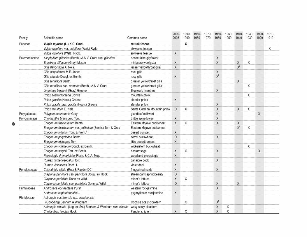
49
2000- 1990- 1980- 1970- 1960- 1950- 1940- 1930- 1920- 1910-Family Scientific name Common name 2003 1999 1989 1979 1969 1959 1949 1939 1929 1919
Poaceae Vulpia myuros (L.) K.C. Gmel. rat-tail fescue XVulpia octoflora var. octoflora (Walt.) Rydb. sixweeks fescue XVulpia octoflora (Walt.) Rydb. sixweeks fescue X
Polemoniaceae Allophyllum gilioides (Benth.) A.& V. Grant ssp. gilioides dense false gilyflower XEriastrum diffusum (Gray) Mason miniature woollystar X X X XGilia flavocincta A. Nels. lesser yellowthroat gilia X Xa
Gilia scopulorum M.E. Jones rock gilia XGilia sinuata Dougl. ex Benth. rosy gilia X Xb
Gilia tenuiflora Benth. greater yellowthroat gilia XGilia tenuiflora ssp. arenaria (Benth.) A.& V. Grant greater yellowthroat gilia XLinanthus bigelovii (Gray) Greene Bigelow’s linanthus XPhlox austromontana Coville mountain phlox XPhlox gracilis (Hook.) Greene slender phlox XPhlox gracilis ssp. gracilis (Hook.) Greene slender phlox XPhlox tenuifolia E. Nels. Santa Catalina Mountain phlox O X X X X
Polygalaceae Polygala macradenia Gray glandleaf milkwort X XPolygonaceae Chorizanthe brevicornu Torr. brittle spineflower X X
Eriogonum fasciculatum Benth. Eastern Mojave buckwheat X O X XEriogonum fasciculatum var. polifolium (Benth.) Torr. & Gray Eastern Mojave buckwheat Xa XEriogonum inflatum Torr. & Frém.e desert trumpet XEriogonum polycladon Benth. sorrel buckwheat O XEriogonum trichopes Torr. little deserttrumpet XEriogonum vimineum Dougl. ex Benth. wickerstem buckwheat XEriogonum wrightii Torr. ex Benth. bastardsage X O X XPterostegia drymarioides Fisch. & C.A. Mey. woodland pterostegia XRumex hymenosepalus Torr. canaigre dock XRumex violascens Rech. f. violet dock X
Portulacaceae Calandrinia ciliata (Ruiz & Pavón) DC. fringed redmaids X XClaytonia parviflora ssp. parviflora Dougl. ex Hook. streambank springbeauty OClaytonia perfoliata Donn ex Willd. miner’s lettuce X XClaytonia perfoliata ssp. perfoliata Donn ex Willd. miner’s lettuce O X X
Primulaceae Androsace occidentalis Pursh western rockjasmine XAndrosace septentrionalis L. pygmyflower rockjasmine X
Pteridaceae Astrolepis cochisensis ssp. cochisensis (Goodding) Benham & Windham Cochise scaly cloakfern O Xb
Astrolepis sinuata (Lag. ex Sw.) Benham & Windham ssp. sinuata wavy scaly cloakfern X XCheilanthes fendleri Hook. Fendler’s lipfern X X X X

50
2000- 1990- 1980- 1970- 1960- 1950- 1940- 1930- 1920- 1910-Family Scientific name Common name 2003 1999 1989 1979 1969 1959 1949 1939 1929 1919
Pteridaceae Cheilanthes parryi (D.C. Eat.) Domin Parry’s lipfern XCheilanthes wootonii Maxon beaded lipfern XNotholaena standleyi Maxon star cloak fern X O X XPellaea mucronata (D.C. Eat.) D.C. Eat. birdfoot cliffbrake XPellaea truncata Goodding spiny cliffbrake X O X
Ranunculaceae Anemone tuberosa Rydb. tuber anemone X X XClematis ligusticifolia Nutt. western white clematis X ODelphinium parishii Gray desert larkspur X XDelphinium parishii Gray ssp. parishii Parish’s larkspur X XMyosurus cupulatus S. Wats. Arizona mousetail XMyosurus nitidus Eastw. western mousetail X
Rhamnaceae Rhamnus crocea Nutt. redberry buckthorn XRhamnus ilicifolia Kellogg hollyleaf redberry XZiziphus obtusifolia var. canescens (Gray) M.C. Johnston lotebush Xb
Ziziphus obtusifolia (Hook. ex Torr. & Gray) Gray lotebush X OZiziphus obtusifolia var. obtusifolia (Hook. ex Torr. & Gray) Gray lotebush X X
Rosaceae Cercocarpus montanus Raf. alderleaf mountain mahogany XCercocarpus montanus var. glaber (S. Wats.) F.L. Martin birchleaf mountain mahogany XRubus arizonensis Focke Arizona dewberry X X
Rubiaceae Galium aparine L. stickywilly X X XGalium stellatum Kellogg starry bedstraw X O X X XGalium triflorum Michx. fragrant bedstraw X
Salicaceae Populus fremontii S. Wats. Fremont cottonwood Xb
Sapindaceae Dodonaea viscosa (L.) Jacq. Florida hopbush X O X X X XScrophulariaceae Castilleja applegatei ssp. martinii (Abrams) Chuang & Heckard wavyleaf Indian paintbrush X X X X X
Castilleja exserta (Heller) Chuang & Heckard exserted Indian paintbrush OCastilleja exserta ssp. exserta (Heller) Chuang & Heckard exserted Indian paintbrush X X X XKeckiella antirrhinoides (Benth.) Straw snapdragon penstemon XKeckiella antirrhinoides ssp. microphylla (Gray) Straw snapdragon penstemon X O X X XMaurandella antirrhiniflora (Humb. & Bonpl. ex Willd.) Rothm. roving sailor X X XMimulus rubellus Gray little redstem monkeyflower XNuttallanthus texanus (Scheele) D.A. Sutton Texas toadflax XPenstemon eatonii Gray Eaton’s penstemon O X XPenstemon eatonii ssp. exsertus (A. Nels.) Keck Eaton’s penstemon XPenstemon subulatus M.E. Jones hackberry beardtongue XSairocarpus nuttallianus (Benth. ex A. DC.) D.A. Sutton violet snapdragon XVeronica anagallis-aquatica L. water speedwell X

51
2000- 1990- 1980- 1970- 1960- 1950- 1940- 1930- 1920- 1910-Family Scientific name Common name 2003 1999 1989 1979 1969 1959 1949 1939 1929 1919
Selaginellaceae Selaginella arizonica Maxon Arizona spikemoss X O X XSimmondsiaceae Simmondsia chinensis (Link) Schneid. jojoba X O X X
Chamaesaracha coronopus (Dunal) Gray greenleaf five eyes Xb
Datura wrightii Regel sacred thorn-apple XSolanaceae Lycium fremontii Gray Fremont’s desert-thorn O X
Lycium pallidum Miers pale desert-thorn XNicotiana attenuata Torr. ex S. Wats. coyote tobacco XNicotiana glauca Graham tree tobacco Xd XNicotiana obtusifolia Mertens & Galeotti desert tobacco XNicotiana obtusifolia var. obtusifolia Mertens & Galeotti desert tobacco X X XPhysalis crassifolia Benth. yellow nightshade groundcherry X XSolanum elaeagnifolium Cav. silverleaf nightshade XSolanum triflorum Nutt. cutleaf nightshade XSolanum xanti Gray chaparral nightshade X
Sterculiaceae Ayenia filiformis S. Wats. TransPecos ayenia OUlmaceae Celtis laevigata Willd. sugarberry X
Celtis laevigata var. reticulata (Torr.) L. Benson netleaf hackberry X O XCeltis pallida Torr. spiny hackberry X O X
Urticaceae Parietaria pensylvanica Muhl. ex Willd. Pennsylvania pellitory X XVerbenaceae Aloysia wrightii Heller ex Abrams Wright’s beebrush X O X
Glandularia bipinnatifida (Nutt.) Nutt. Dakota mock vervain XGlandularia gooddingii (Briq.) Solbrig southwestern mock vervain X X
Violaceae Hybanthus verticillatus (Ortega) Baill. babyslippers XViscaceae Phoradendron bolleanum (Seem.) Eichl. Bollean mistletoe X
Phoradendron californicum Nutt. mesquite mistletoe X XZygophyllaceae Kallstroemia californica (S. Wats.) Vail California caltrop X
Kallstroemia parviflora J.B.S. Norton warty caltrop XLarrea tridentata (Sessé & Moc. ex DC.) Coville creosote bush X X Xb
Larrea tridentata var. tridentata (Sessé & Moc. ex DC.) Coville creosote bush Oa Specimens found at the University of Arizona Herbarium.b Burgess (1965).c Phillips (1992).d Halvorson and Guertin (2003).e Specimen has no date.? Species identification questionable.

52
Appendix B. List of amphibians and reptiles found at Tonto NM by University of Arizona inventory personnel and Swannet al. (SWN; 1996). Order Family Scientific name Common name UA SWNAnura Bufonidae Bufo alvarius Sonoran desert toad X
Bufo punctatus red-spotted toad XBufo woodhousii Woodhouse’s toad X XBufo cognatus Great plains toad XHyla arenicolor canyon treefrog XScaphiogus couchii Couch’s spadefoot X
Testudines Kinosternidae Kinosternon sonoriense Sonoran mud turtle XSquamata Gekkonidae Coleonyx variegatus western banded gecko X X
Scincidae Eumeces obsoletus Great Plains skink XPhrynosomatidae Cophosaurus texanus greater earless lizard X X
Crotaphytus collaris common collared lizard XEumeces obsoletus Great plains skink XCallisaurus draconoides zebra-tailed lizard X XPhrynosoma solare regal horned lizard XSceloporus clarkia Clark’s spiny lizard XSceloporus magister desert spiny lizard X XUta stansburiana common side-blotched lizard X XUrosaurus ornatus ornate tree lizard X XXantusia vigilis desert night lizard X
Teiidae Cnemidophorus sonorae Sonoran spotted whiptail X XCnemidophorus flagellicaudus Gila spotted whiptail XCnemidophorus tigris western whiptail X X
Anguidae Elgaria kingii Madrean alligator lizard X XHelodermatidae Heloderma suspectum Gila monster XColubridae Diadophis punctatus ring-necked snake X X
Hypsiglena torquata night snake XMasticophis bilineatus Sonoran whipsnake XMasticophis flagellum coachwhip XPituophis catenifer gopher snake X XRhinocheilus lecontei long-nosed snake XSalvadora hexalepis western patch-nosed snake XSonora semiannulata ground snake XTantilla hobartsmithi southwestern black-nosed snake XLampropeltis getula common kingsnake X XThamnophis cyrtopsis black-necked garter snake XTrimorphodon biscutatus western lyre snake X X
Elapidae Micruroides euryxanthus Sonoran coral snake X XViperidae Crotalus viridus cerberus Arizona black rattlesnakes X
Crotalus atrox western diamond-backed rattlesnake X XCrotalus molossus black-tailed rattlesnake X X

53
Appendix C. Bird species recorded by University of Arizona Inventory personnel (UA), Tonto NM, 2001–2003 or that werereported in Hiett and Halvorson (H&H;1995). Hiett and Halvorson summarized historical observations. Order Family Scientific name Common name UA H&HAnseriformes Anatidae Branta canadensis Canada goose X
Anas platyrhynchos mallard XGalliformes Phasianidae Meleagris gallopavo wild turkey X
Odontophoridae Callipepla gambelii Gambel’s quail XPelecaniformes Pelecanidae Pelecanus erythrorhynchos American white pelican XCiconiiformes Ardeidae Ardea herodias great blue heron X
Cathartidae Cathartes aura turkey vulture XFalconiformes Accipitridae Pandion haliaetus osprey X
Haliaeetus leucocephalus bald eagle XCircus cyaneus northern harrier XAccipiter striatus sharp-shinned hawk XAccipiter cooperii Cooper’s hawk XAccipiter gentilis northern goshawk XParabuteo unicinctus Harris’s hawk XButeo swainsoni Swainson’s hawk XButeo albonotatus zone-tailed hawk XButeo jamaicensis red-tailed hawk XButeo regalis ferruginous hawk XAquila chrysaetos golden eagle X
Falconidae Falco sparverius American kestrel XFalco columbarius merlin XFalco peregrinus peregrine falcon XFalco mexicanus prairie falcon X
Columbiformes Columbidae Patagioenas fasciata band-tailed pigeon XZenaida asiatica white-winged dove XZenaida macroura mourning dove XColumbina passerina common ground-dove X
Cuculiformes Cuculidae Coccyzus americanus occidentalis yellow-billed cuckoo XGeococcyx californianus greater roadrunner X
Strigiformes Tytonidae Tyto alba barn owl XStrigidae Megascops kennicottii western screech-owl X
Glaucidium brasilianum cactorum cactus ferruginous pygmy-owl XBubo virginianus great horned owl XMicrathene whitneyi elf owl XStrix occidentalis lucida Mexican spotted owl X
Caprimulgiformes Caprimulgidae Chordeiles acutipennis lesser nighthawk XChordeiles minor common nighthawk XPhalaenoptilus nuttallii common poorwill X
Apodiformes Apodidae Aeronautes saxatalis white-throated swift XTrochilidae Archilochus alexandri black-chinned hummingbird X
Calypte anna Anna’s hummingbird XCalypte costae Costa’s hummingbird XSelasphorus platycercus broad-tailed hummingbird XSelasphorus rufus rufous hummingbird X
Piciformes Picidae Melanerpes formicivorus acorn woodpecker XMelanerpes uropygialis Gila woodpecker XSphyrapicus varius yellow-bellied sapsucker XSphyrapicus nuchalis red-naped sapsucker XPicoides scalaris ladder-backed woodpecker XColaptes auratus northern flicker XColaptes chrysoides gilded flicker X

54
Order Family Scientific name Common name UA H&H
Passeriformes Tyrannidae Contopus cooperi olive-sided flycatcher XContopus sordidulus western wood-pewee XEmpidonax hammondii Hammond’s flycatcher XEmpidonax wrightii gray flycatcher XEmpidonax oberholseri dusky flycatcher XEmpidonax difficilis pacific-slope flycatcher XEmpidonax occidentalis cordilleran flycatcher XSayornis nigricans black phoebe XSayornis saya Say’s phoebe XPyrocephalus rubinus vermilion flycatcher XMyiarchus cinerascens ash-throated flycatcher XMyiarchus tyrannulus brown-crested flycatcher XTyrannus vociferans Cassin’s kingbird XTyrannus verticalis western kingbird X
Laniidae Lanius ludovicianus loggerhead shrike XVireonidae Vireo bellii Bell’s vireo X
Vireo vicinior gray vireo XVireo flavifrons yellow-throated vireo XVireo cassinii Cassin’s vireo XVireo huttoni Hutton’s vireo XVireo gilvus warbling vireo XVireo olivaceus red-eyed vireo X
Corvidae Cyanocitta stelleri Steller’s jay XAphelocoma californica western scrub-jay XGymnorhinus cyanocephalus pinyon jay XNucifraga columbiana Clark’s nutcracker XCorvus corax common raven X
Hirundinidae Progne subis purple martin XTachycineta thalassina violet-green swallow XStelgidopteryx serripennis northern rough-winged swallow XPetrochelidon pyrrhonota cliff swallow XHirundo rustica barn swallow X
Paridae Poecile gambeli mountain chickadee XBaeolophus wollweberi bridled titmouse X
Remizidae Auriparus flaviceps verdin XAegithalidae Psaltriparus minimus bushtit XSittidae Sitta carolinensis white-breasted nuthatch XCerthiidae Certhia americana brown creeper XTroglodytidae Campylorhynchus brunneicapillus cactus wren X
Salpinctes obsoletus rock wren XCatherpes mexicanus canyon wren XThryomanes bewickii Bewick’s wren XTroglodytes aedon house wren X
Regulidae Regulus calendula ruby-crowned kinglet XSylviidae Polioptila caerulea blue-gray gnatcatcher X
Polioptila melanura black-tailed gnatcatcher XTurdidae Sialia mexicana western bluebird X
Sialia currucoides mountain bluebird XMyadestes townsendi Townsend’s solitaire XCatharus guttatus hermit thrush XTurdus migratorius American robin X
Mimidae Mimus polyglottos northern mockingbird XOreoscoptes montanus sage thrasher XToxostoma curvirostre curve-billed thrasher X
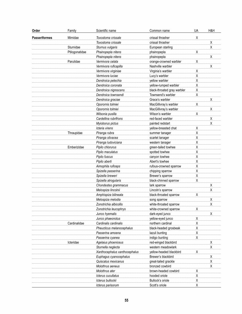
55
Order Family Scientific name Common name UA H&H
Passeriformes Mimidae Toxostoma crissale crissal thrasher XToxostoma crissale crissal thrasher X
Sturnidae Sturnus vulgaris European starling XPtilogonatidae Phainopepla nitens phainopepla X
Phainopepla nitens phainopepla XParulidae Vermivora celata orange-crowned warbler X
Vermivora ruficapilla Nashville warbler XVermivora virginiae Virginia’s warbler XVermivora luciae Lucy’s warbler XDendroica petechia yellow warbler XDendroica coronata yellow-rumped warbler XDendroica nigrescens black-throated gray warbler XDendroica townsendi Townsend’s warbler XDendroica graciae Grace’s warbler XOporornis tolmiei MacGillivray’s warbler XOporornis tolmiei MacGillivray’s warbler XWilsonia pusilla Wilson’s warbler XCardellina rubrifrons red-faced warbler XMyioborus pictus painted redstart XIcteria virens yellow-breasted chat X
Thraupidae Piranga rubra summer tanager XPiranga olivacea scarlet tanager XPiranga ludoviciana western tanager X
Emberizidae Pipilo chlorurus green-tailed towhee XPipilo maculatus spotted towhee XPipilo fuscus canyon towhee XPipilo aberti Abert’s towhee XAimophila ruficeps rufous-crowned sparrow XSpizella passerina chipping sparrow XSpizella breweri Brewer’s sparrow XSpizella atrogularis black-chinned sparrow XChondestes grammacus lark sparrow XMelospiza lincolnii Lincoln’s sparrow XAmphispiza bilineata black-throated sparrow XMelospiza melodia song sparrow XZonotrichia albicollis white-throated sparrow XZonotrichia leucophrys white-crowned sparrow XJunco hyemalis dark-eyed junco XJunco phaeonotus yellow-eyed junco X
Cardinalidae Cardinalis cardinalis northern cardinal XPheucticus melanocephalus black-headed grosbeak XPasserina amoena lazuli bunting XPasserina cyanea indigo bunting X
Icteridae Agelaius phoeniceus red-winged blackbird XSturnella neglecta western meadowlark XXanthocephalus xanthocephalus yellow-headed blackbird XEuphagus cyanocephalus Brewer’s blackbird XQuiscalus mexicanus great-tailed grackle XMolothrus aeneus bronzed cowbird XMolothrus ater brown-headed cowbird XIcterus cucullatus hooded oriole XIcterus bullockii Bullock’s oriole XIcterus parisorum Scott’s oriole X

56
Order Family Scientific name Common name UA H&H
Passeriformes Fringillidae Carpodacus purpureus purple finch XCarpodacus cassinii Cassin’s finch XCarpodacus mexicanus house finch XCarduelis pinus pine siskin XCarduelis psaltria lesser goldfinch XCarduelis lawrencei Lawrence’s goldfinch XCarduelis tristis American goldfinch XCoccothraustes vespertinus evening grosbeak X
Passeridae Passer domesticus house sparrow X

57
Appendix D. List of mammals observed at Tonto NM by University of Arizona Inventory personnel (UA), Swann et al.(SWN;1996), and Bucci and Petryszyn (B&P;2004). Non-native species are in bold-faced type.Order Family Scientific name Common name UA SWN B&PChiroptera Vespertilionidae Myotis lucifugus little brown myotis X
Myotis auriculus southwestern myotis XMyotis yumanensis Yuma myotis X XMyotis velifer cave myotis X XMyotis californicus California myotis XMyotis ciliolabrum western small-footed myotis XPipistrellus hesperus western pipistrelle X XEptesicus fuscus big brown bat XCorynorhinus townsendii Townsend’s big-eared bat XAntrozous pallidus pallid bat X X
Molossidae Tadarida brasiliensis Mexican freetail bat XNyctinomops femorosaccus pocketed freetail bat XNyctinomops macrotis big freetail bat XEumops perotis western bonneted bat X X
Rodentia Soricidae Notiosorex crawfordi desert shrewSciuridae Spermophilus variegatus rock squirrel X
Neotamias dorsalis cliff chipmunk XAmmospermophilus harrisii Harris’ antelope ground squirrel X
Heteromyidae Chaetodipus baileyi Bailey’s pocket mouse XDipodomys merriami Merriam’s kangaroo rat X
Muridae Peromyscus eremicus cactus mouse XOnychomys torridus southern grasshopper mouse XNeotoma albigula western white-throated woodrat XMus musculus house mousea
Erethizontidae Erethizon dorsatum porcupine XCarnivora Procyonidae Nasua narica white-nosed coati X
Bassariscus astutus ringtail XProcyon lotor common raccoon
Mustelidae Conepatus mesoleucus common hog-nosed skunkMephitis macroura hooded skunkMephitis mephitis striped skunkSpilogale gracilis western spotted skunk XTaxidea taxus American badger X
Canidae Urocyon cinereoargenteus common gray fox XCanis latrans coyote X
Felidae Felis catus feral cat XFelis concolor mountain lionLynx rufous bobcat
Ursidae Ursus americanus American black bear XLagomorpha Leporidae Sylvilagus audubonii desert cottontail X
Sylvilagus floridanus Eastern cottontailLepus californicus black-tailed jack rabbit X
Artiodactyla Tayassuidae Pecari tajacu collared peccary XCervidae Odocoileus hemionus mule deer X
Odocoileus virginianus white-tailed deer Xa Trapped by Erika Nowak (pers. comm.).