Embed Size (px)
Citation preview
VALUING THE
UPPER TENMILE CREEK A STUDY OF FUTURE LAND USES
AT A SUPERFUND SITE
LEWIS AND CLARK COUNTY MONTANA
PROJECT REPORT
AUGUST 2004
PROJECT TEAM
E2 INC DIRT WEST
FUNDED BY
US ENVIRONMENTAL PROTECTION AGENCY
SUPERFUND REDEVELOPMENT INITIATIVE (SRI) 1
Project Timeline
October 1999 Upper Tenmile Creek Site Listed on
the National Priorities List
Fall 2002 Community Receives Funding from Superfund Redevelopment Initiative to undertake Reuse Planning Process
November 2002 Project Teamrsquos First
Site Visit
May 2003 First Land Use Committee Meeting at the Old School House in Rimini
June 2003 Community Values Survey sent to
the Upper Tenmile Creek Land Use Committee
August 2003 Final Land Use Committee Meeting held to Present Draft Land Use Guidelines and Draft Land Use Proposals for Discussion
2
Project Scope
The US Environmental Protection Agency (US EPA)rsquos primary responsibility at Superfund sites is the protection of human health and the environment Since 1995 it has also been US EPA policy to consider potential future land uses when making remedy decisions at Superfund sites so that the remediation of Superfund sites does not preclude future use for commercial recreational ecological or other purposes Since 1999 US EPArsquos Superfund Redevelopshyment Initiative (SRI) has been helping communities and stakeholders plan for reuse at more than 70 National Priorities List (NPL) sites across the country
Reuse planning at NPL sites presents a unique set of obstacles challenges and opportunities Superfund site designation represents a commitment from US EPA that a sitersquos contamination will be remediated and that the site will be made safe for human health and the environment However reuse considerations at these sites can be complicated by many factors including the level and complexity of contamination unclear or resistant site ownership or community concerns about health and the environment all of which can lead to a lengthy and contentious process Any successful reuse planning effort must be mindful of how a sitersquos reuse and remediation will work together involve the capacity of diverse stakeholders to meaningfully participate in the process and take into account the long time frames often involved in NPL site remediation
In 2002 the City of Helena and Lewis and Clark County received assistance from SRI to undertake a community-based planning process to develop future land use recommendations for the 53 square mile (33900 acres) Upper Tenmile Creek Superfund site During the planning process a committee of local residents from the Upper Tenmile Creek watershed and individuals from the city of Helena met with environmental consultants from E2 Inc and landscape architects from DIRT West (the Project Team) and with support from US EPA The process resulted in the Draft Land Use Guidelines and Draft Land Use Proposals presented in part three of this report While members of the committee (referred to as the Land Use Committee) all shared a deep commitment to and respect for the Upper Tenmile Creek watershed they had a wide range of interests and priorities for land use within the watershed site As such the Draft Land Use Guidelines and Draft Proposals are an attempt to balance the various goals of the Land Use Committee members After they were presented to the community in August 2003 it became clear that reaching consensus for approval would be difficult and therefore it was determined that no effort would be made to develop a more detailed land use plan for the Upper Tenmile Creek Superfund site The Draft Land Use Guidelines and Draft Land Use Proposals are presented in this report to further encourage discussion within the community as well as potentially inform and direct the sitersquos remedial design and implementation ensuring that land use considerations are taken into account in future community planning efforts
This report includes site background information in addition to the Draft Land Use Guidelines and Draft Proposals The recommendations within the report were informed by the Land Use Committee over the course of two community meetings At these meetings discussions focused on both the natural and industrial history of the site existing land use patterns within the watershed and the status of remediation A survey of important community values was also sent to the Land Use Committee and helped inform the Project Teamrsquos recommendations Based on these discussions and the values survey the Project Team developed this report as a resource to help guide future land use within the watershed Additionally the Team reviewed the Lewis and Clark Growth Policy to determine how land use guidelines could be applied to the Upper Tenmile Creek watershed should the community want to pursue this option The review is included in the appendices of the report Finally the Project Team identified resources for historic preservation and road removal which are also included in the appendices of this report
Currently E2 Inc is working with the City of Helena Lewis and Clark County state agencies and US EPA to evaluate integrated land transfer and water management opportunities in the Upper Tenmile Creek watershed These opportunities could enable the development of effective lower-cost remedial components and enhance local water planning efforts and infrastructure
3
Acknowledegments
The Project Team would like to thank the following people for their participation in the reuse planning process for the Upper Tenmile Creek Superfund site
Land Use Committee Members
Doug Abelin Jesse Aber Ron Alles Carl Anderberg Jaime Arnold John Arrico Andy Baur Randy Beckner Fred A Bailey Bret Boundy Tim Burton Joan Connole Kurt Cuneo Jorjena Daly Dave Gardner Jon Gatchell Don Gordon Eric Griffin Eric Grove Diana Hammer
Douglas Herold Gary Ingman Gayle Joslin Keith Large Kathy Lloyd Tom Mandera Dave Mason Neil Marsh Michael McHugh Leonard Pickett Jim Posewitz Don Reimer John Rundquist David Rusoff Don Skaar Colonel Allan Stricker Chuck Watters Jim Wilbur
In particular the Project Team would like to thank Mike Bishop site Remedial Project Manager for the Upper Tenmile Creek Superfund site for his commitment to the project and the people who reside within the watershed
view of the Upper Tenmile Creek
4
Table of Contents
Project Timeline page 2 Project Scope page 3 Acknowledgements page 4 Table of Contents page 5
Part One The Upper Tenmile Creek Watershed page 6-12 Ecology page 7 Social + Industrial History page 9 Post-Industrial Landscape page 9 Current Land Use page 10-11 Reclamation page 12
Part Two Community Values + Goals page 13
Park Three Future Considerations page 15-17 Draft Land Use Guidelines page 15 Draft Land Use Proposals page 16-17
Appendices
Appendix A List and Map of Species of Special Concern in Montana page 18-19 Appendix B First Land Use Committee Meeting Notes page 20-21 Appendix C Planning Development in the Upper Tenmile Creek Watershed page 22 Appendix D Opportunities for National Historic Registration page 23 Appendix E Guide to Removing Unwanted Roads in Wilderness Areas page 24 Appendix F California Gulch Case Study Lake County CO page 24
5
clockwise from left water map of the Upper TenmileCreek watershed Scott Reservoir Chessman Reservoir
6
PART ONE The Upper Tenmile Creek Watershed
Ecology
The Upper Tenmile Creek watershed sits in the East Front of the Rocky Mountains This area is a spectacular and expansive landscape at the juncture of the Rocky Mountains and the western margin of the Northern Great Plains In Montana the East Front encompasses an area that extends northwest from near the city of Helena to the Canadian border The East Frontrsquos abrupt change from rolling prairie to mountain topography produces significant elevational and climactic gradients creating a high level of species and ecological diversity Ecosystems range from high-elevation alpine tundra to mountain forest and from glaciated wetlands to mid-grass prairie
The East Frontrsquos native plant and animal populations are generally intact due to sparse settlement and an economy based principally on ranching The East Front is an integral part of the Northern Continental Divide Ecosystem one of the only remaining areas in the continental United States with an intact assemblage of large mammalian carnivores The Continental Divide itself forms the western boundary of the Upper Tenmile Creek Watershed Grizzly bear gray wolf wolverine and lynx ndash all considered rare or endangered species in the United States ndash still exist here Rare birds found along the East Front include boreal owls ferruginous hawks and trumpeter swans ndash all listed as Species of Special Concern in Montana (see Appendix A) Populations of westslope cutthroat trout bull trout and harlequin ducks can still be found in higher mountain streams Arctic grayling have been extirpated from the East Front but efforts are underway to reestablish grayling in historic streams The plant communities in the watershed are dominated by alpine meadows with some grasslandsrangelands and some land classified as barren Dominant tree species within the watershed include Quaking Aspen Douglas Fir Lodgepole Pine Engelmann Spruce Whitebark Pine Limber Pine and Alpine Fir among others
Tenmile Creek
The headwaters of Tenmile Creek are about six miles upstream of the town of Rimini Tenmile Creek flows northward for 28 miles before entering Lake Helena although only the first 13 miles of the creek are included within the boundaries of the Superfund site The Tenmile Creek watershed drains 200 square miles of mountainous and valley terrain primarily to the south and west of the city of Helena The Lower Tenmile Creek Watershed which extends downstream from the Tenmile Water Treatment Plant drains 150 square miles and is used primarily for agricultural irrigation The Upper Tenmile Creek watershed which consists of those waters upstream from the Tenmile Water Treatment Plant drains 50 square miles
Water diverted from Upper Tenmile Creek provides 70 percent of Helenarsquos municipal water from June through September and 100 percent of the cityrsquos water from October through May Diversions for municipal water are located on the Tenmile Creek south of Rimini and near the mouths of Beaver Minnehaha Moose and Walker creeks Additional water is obtained from the Scott and Chessman reservoirs which collect water from several watershed tributaries during periods of high stream-flow This water is held in reserve and accessed on an as-needed basis
7
8
Social + Industrial History
Prior to the mining industryrsquos dominance over much of the landscape of Montana the Blackfeet Indians were the largest and most dominant Indian Tribe in Montana Once considered ldquoThe Lords of the Great Plainsrdquo like other tribes during this time their way of life was eventually overtaken by the expansion of the West and the development of hard rock mining
Historic mining activity occurred within the Rimini Mining District and included mining for gold lead zinc and copper According to the July 1935 issue of the Mining Review of the Greater Helena Region Rimini is likely ldquothe oldest silver-lead-zinc camp in Montana if not the Northwestrdquo While the first major gold strike in Montana occurred in the Helena mining district in 1862 it was not until 1864 that miners entered the Rimini area In 1864 the Lee Mountain lode was discovered and within ten years the Rimini mining district was producing nearly one-third of the territoryrsquos mineral wealth In the 1880s mining in the district received a boost from the construction of the Alta-Montana Smelter and the Helena and Red Mountain Railroad By 1891 the Rimini mining district was shipping 400 tons of silver ore per week However by the end of 1893 with silver prices plummeting most of the mines in the region had shut down In total between 1864 and 1937 the Rimini mining district produced minerals with an estimated total value of $7000000 The district yielded 80000 ounces of gold 3310000 ounces of silver and 13500000 pounds of lead in addition to small amounts of other metals
Mining operations for other minerals continued into the 1930s In 1929 for example the Montana Lead Company organized by the estate of James J Hill the former president of the Great Northern Railroad drove the Red Mountain Tunnel 1000 feet through Red Mountain to consolidate the Red Mountain mines along a single tunnel By 1934 the company was one of the major producers of lead in Montana Declining prices however forced the closure of the mines in 1937 The last active commercial mining of the Rimini Mining District ended in 1953
Post-Industrial Landscape
Beginning in the mid-1930s new activities developed in the district beyond mining In 1936 a Civilian Conservation Corps Camp was established near Rimini and was later converted for military use under the Dogs for Defense program during World War II The War Dog Reception and Training Center began training sled and pack dogs to support special service forces during the planned invasion of Norway In June 1943 the invasion of Norway was canceled and soldiers at Camp Rimini focused on search and rescue training
left clockwise from top left former rail bed remnant mining structure Rimini schoolhouse old Headquarters Saloon This page remains from Riminirsquos past
9
Current Land Use
The Upper Tenmile Creek NPL site extends from US Highway 12 south to the drainage divide adjoining the basin creek Cataract Creek and Teleshygraph Creek watersheds To the west the site is bounded by the Contishynental Divide which stretches from Canada into Arizona The United States Forest service owns over 70 percent of the sitersquos land area Additional landowners at the site include the Bureau of Land Management and sevshyeral private landowners who reside within the watershed
In addition to serving as the source for Helenarsquos primary municipal water supply the Upper Tenmile Creek Watershed is a popular resource for people and wildlife alike Residents and individuals who reside nearby enjoy huntshying hiking biking snow-related activities and motorized vehicle riding in areas throughout the watershed With the Continental Divide adjacent to the site the watershed also serves as a vital wildlife habitat and migration corridor Additional land uses in the watershed include timber harvesting and mine reclamation
Rimini
The town of Rimini once the hub of the Rimini Mining District is situated in the center of the Upper Tenmile Creek Watershed approximately eight miles southwest of Helena While the city of Helena has 25780 residents Rimini is much less populated (approximately 20 people) with no zoning regulations or authorities The city of Helena and town of Rimini are loshycated within Lewis and Clark County which has a population of 55716
During its heyday Rimini was home to a dozen bars and brothels and nearly 2000 people Although the population is much smaller today Rimini and its surroundings still retain many memories from the past evident in the number of historic structures and artifacts located throughout the area including former mines mining structures and historic buildings that document Riminirsquos industrial and post-industrial heritage
Site Access + Circulation
The Upper Tenmile Creek Watershed is currently accessed by a single land use map of Upper Tenmile Creek watershed (source USGS) primary access road County Route 695 This unpaved road extends from
10
Route 12 near the Tenmile Water Treatment Plant into the watershed Plans are under development to pave the road from Route 12 south into the community of Rimini Two secondary unpaved roads provide access from the valley to the Continental Divide at Bear Gulch and Minnehaha Creek Other unpaved roads extend from the community of Rimini south toward Luttrell Peak and east toward Chessman Reservoir In addition to these designated roads additional unmapped primitive roads exist throughout the watershed
There are several trail and road systems in the watershed including secondary roads and an Environmental Educational Trail at Lazyman Gulch The Continental Divide Trail runs along the western boundary of the Superfund Site while many additional trails and wildlife corridors cross the watershed The US Forest Service is currently inventorying these trails and creating a Travel Plan for access and circulation within the watershed site Near Helena an extensive system of trails covers more than 1600 acres of city-owned public land
The Continental Divide Trail
In 1978 Congress designated a 50-mile-wide corridor on either side of the Continental Divide for the Continental Divide Trail (CDT) This is one of eight National Scenic Trails in the US The CDT runs from Canada to Mexico routed through five states Montana Idaho Wyoming Colorado and New Mexico Approximately 70 percent of the Trail is complete According to the Continental Divide Trail Society the CDT is a resource for hikers The Helena segment of the trail is described as ldquoless rugged country mostly forestedrdquo with some road sections that exist in this portion of the trail The USFS has the responsibility of coordinating its completion along with the National Park Service (NPS) and the Bureau of Land Management (BLM)
view towards site from Continental Divide trail
11
Reclamation
The US EPA added the Upper Tenmile Creek Mining Area to its Superfund National Priorities List in 1999 due to contamination from abandoned gold lead zinc and copper mines and mine wastes on water quality in the watershyshed as well as concern for the general health and safety of residents and the environment To date 150 mine sites have been identified within the watershyshed - 70 of which are high-priority for remedial action
The sitersquos history of remedial activities includes a series of waste removal and containment actions by the State of Montana over the last 15 years EPA and the US Forest Service conducted several high-priority mine waste removal actions between 1999 and 2000 Areas addressed by the waste removal acshytions include the Red Mountain Bunker Hill and Susie PeerlessJennyKing mines as well as the Upper Valley Forge Mine Sites Mine waste removal actions occurred within the Town of Rimini in 2003
According to the EPA contaminated media at the Upper Tenmile Creek Superfund site include waste rock and tailings acid mine drainage (AMD) groundwater surface water stream sediments yard soils at permanent resishydences and occasional-use recreational cabins roadway materials and the Rimini water supply EPArsquos seshylected remedy for the Upper Tenmile Creek Superfund site as described in the 2002 Record of Decision addresses each of these contaminated media
left map of mining locations within the Upper Tenmile Creek NPL site Leemine undergoing reclamation
12
PART TWO Community Values and Goals
The Project Team and site Remedial Project Manager assembled a group of concerned citizens who live within the watershed the City of Helena and Lewis and Clark County to take part in a Land Use Committee to help guide and inform the planning exercise The Project Team looked to the Land Use Committee to provide valuable input and information to direct their recommendations regarding future growth and land use patterns in the watershed Over the course of two meetings the Project Team and the Land Use Committee discussed important issues regarding the sitersquos history natural resources and site access and circulation Between meetings the Project Team sent to the LUC a short survey of important values held by those who live within the watershed and the region Questions posed included ldquoWhat do you most value about the Upper Tenmile Creek watershedrdquo rdquoHow do you feel about the current land uses that occur in the watershedrdquo and ldquoWhat additional uses would you like to see or see more of What uses would you NOT like to see or NOT see more ofrdquo The results of the survey are summarized below divided into community values and current and future land use goals
Community Values
middot Wildlife Based on comments the highest values attributed to the Upper Tenmile Creek Watershed is as both a crucial region for wildlife habitat and an invaluable wildlife migratory corridor
middot Recreation Respondents noted the value of the watershedrsquos diverse recreational amenities for the use of private landowners and the general public
middot Historic Preservation and Interpretation Limited mention of the value of historic preservation in the Upper Tenmile Creek watershed Histories and structures that were mentioned as imshyportant to preserve and interpret included the mining and Forest Service history the WWII camp and the historic structures and character of the town of Rimini
middot Character and Integrity of Landscape Other values included the tranquility of the area the ldquowildrdquo character of the landscape the aesthetic value of the gulch the lack of traffic and a ldquoslower pacerdquo than that found in the city
Current and Future Land Use Goals
middot Maintain Existing Land Uses Most individuals who responded are comfortable with the existing land uses within the watershed which traditionally include recreation living hunting logging thinning and other efforts to reduce the fuel load in the watershed to maintain a healthy forest ecosystem
middot Reclamation Activities and Roads Many land use concerns relate to the mining reclamation activities at the site and the affects on the residents of Rimini and the wildlife that inhabit and move through the area One fear is that reclamation will create roads that divide the watershed and encourage unwanted activity Additionally there is concern that the plan for a paved road into Rimini will negatively impact the existing community and current land uses
middot Controlled Development Controlled development in the watershed is a primary goal May responshydents mentioned a desire to see no new developments within the watershyshed including commercial enterprises paved roads and subdivisions as well as limited to no residential growth tourist attractions and new campgrounds that destroy the ldquowildrdquo and public nature of the watershed
middot Upper Tenmile Creek Water System A future that does not include the use of the Tenmile Creek as the primary municipal water supply for Helena was a popular idea among survey reshyspondents
13
left wildlife habitat and corridors in the UpperTenmile Creek watershed (source Gayle JoslinMontana Dept of Fish Wildlife and Parks) above grizzly bear(source Milo Burcham from brochureldquoEffects of Recreation on Rocky Mountain Wild-liferdquo Montana Chapter of The Wildlife Society)
14
PART THREE Future Considerations for the Upper Tenmile Creek Watershed
Upon receiving of the results of the survey of community values and land use goals for the watershed the Project Team developed the following Draft Land Use Guidelines
Draft Land Use Guidelines
MAINTAIN ALL OF THE EXISTING LAND USES IN THE UPPER TENMILE CREEK WATERSHED - Maintain the diversity of recreation amenities forest uses and access options - Enhance existing amenities BEFORE creating new amenities - Allow for living and dwelling within the watershed
PRESERVE AND ENHANCE THE EXISTING WILDLIFE HABITAT AND CORRIDORS - Recognize and promote the watershed as a crucial wildlife habitat and corridor - Protect and enhance habitat (forests meadows streams) - Keep corridors in tact and continuous particularly along the Continental Divide
CONTINUE TO SUPPORT EFFORTS FOR A CLEAN WATERSHED AND WATER SYSTEM - Help EPA to work quickly and efficiently at cleaning up the watershed - Support work of the Upper Tenmile Creek Watershed Steering Group - Support the proposal to remove the Upper Tenmile Creek as a primary water supply for the City of Helena
MAINTAIN THE CHARACTER INTEGRITY AND EXPERIENCE OF THE LANDSCAPE - Control large scale developments within the Watershed and Lower Tenmile Creek Valley - Create and define an entry experience into the valley (limit road width paving and alignment remove
unnecessary spur roads define and enhance public areas preserve integrity of Rimini respect property rights)
- Utilize remediation activities to create a better watershed (document the history of the area protect and enhance habitat control expansion of roads and trails)
15
Draft Land Use Proposals
The following Land Use Proposals correspond to the ldquoDraft Land Use Proposshyals Diagramrdquo at right Numbers located on the map relate to the areas desigshynated below Suggestions under each designated area are intended to proshyvide broad guidelines for reuse within the 33900 acres that comprise the Upper Tenmile Creek Watershed Superfund site
1 ROUTE 12 AND LOWER TENMILE CREEK VALLEY (Continental Divide to the City of Helena) - Protect valley as a visual and cultural entry corridor to the Continental
Divide and to the City of Helena Route 12 is the front door and front yard to the Upper Tenmile Creek Watershed
- Consider development non-development options This valley is prime land for development with easy access to city and recreation amenishyties Valley terrain is flat and would allow for easy parceling or subdishyvision development if community desires
2 RIMINI ROAD AND UPPER TENMILE CREEK VALLEY (Route 12 to Rimini) - Rethink Rimini Road (route 695) as the lsquoRecreation Highwayrsquo Creshy
ate the narrowest possible road with limited paving narrow shoulshyders and as far away from the creek as possible
- Remove and control spur roads trails and parking areas along route 695
- Limit developments excessive entry drives logging and new uses along route 695
- Continue stream revegetation efforts
3 LAZYMAN GULCH DAY-USE AREA MOOSE CREEK CAMPGROUND AND MOOSE CREEK RANGER STATION - Improve and link existing amenities including Lazyman Day-Use Area
Moose Creek Campground the former Ranger Station Create adshyequate parking areas and connect via trails
- Create a defined winter parking area at Moose Creek Campground and connect to winter access routes via former rail line
- Consider former Ranger Station as a public facility allowing for inforshy16
mation and interpretation of the watershed and its history Consider nomination of Ranger Station to the National Register of Historic Places
4 RIMINI - Maintain the character of Rimini and other private properties as places for living NOT as public landshy
scapes for viewing tourists or interpretation - Control speed marking and paving on roads through town - Consider nominating the Rimini School House to the National Register of Historic Places as a place of
community pride
5 WATERSHED ROADS (Roads and Trails North of Rimini) - Consider and evaluate USFS Travel Plan and proposed restrictions in relation to the watershed land
use proposals - Reduce road widths shoulders and pullouts on all roads north of Rimini to the narrowest possible
standards Reduce roads widened for waste relocation vehicles to off-road vehicle standards not for autos and RVs
- Control spur roads and trails through remediation efforts
6 CONTINENTAL DIVIDE WILDLIFE CORRIDOR AND RECREATION AREA - Protect and enhance habitat and corridors west of Rimini and Rimini Road to the Continental Divide - No new developments roads road widening trails or amenities Consider travel restrictions as part of
USFS Travel Plan
7 RESERVOIRS AND RED MOUNTAIN (Chessman Reservoir Beaver Creek Red Mountain Scott Resershyvoir Ruby Creek and Banner Creek) - Create recreational amenity wildlife habitat or combination land use area Begin post-water swap land
use planning - Consider Chessman Reservoir flumes and mines as recreation trails historical interpretation and stream
restoration areas
8 REMEDIATION ACTIVITIES - Phase remediation from north to south Expedite work within the public realm ie Rimini along valley
floor and in Landmark subdivision - Remove not just restore to existing conditions as many access roads as possible in the watershed - Continue historic records documentation and work to find suitable public lodging or sponsor for informashy
tion collected 17
APPENDICES
Appendix A List and Map of Species of Special Concern in Montana (source Montana Natural Heritage Program)
18
19
Appendix B First Land Use Committee Meeting Notes
During this first Land Use Committee meeting on May 29 2003 the Project Team conducted an informal survey of the LUC members in the room Following is a summary of the LUC membersrsquo responses
When asked what are some valuable historic events and resources of the UTC the following were responses from LUC members middot The town of Rimini middot The mining structures and the waste piles middot The National Forest Reserves (1891-1907) middot Moose Creek Ranger Station middot Narrow Gauge Railroad bed middot Chessman Reservoir and its associated plume middot Blackfeet Indians and their travel routes middot 1923 Grizzly Protection in Montana middot Luttrell Pit middot Flood of 1981 that changed the stream configuration of the Upper Tenmile Creek middot General growth or recreation in the area middot Change in Rimini population due to mining middot Early 1900s Chessman Flood middot Earliest water rights of 1860s middot Mountaineering and dog camp for the US Special Forces middot USFS history middot The old School building middot The Saloon
When asked how the community might mark this history at the site the following were responses from LUC members middot Utilize the School building as a historic marker on site with an associated parking lot and lsquointerpretive walkrsquo middot Develop a walking tour with an audio guide particularly focused on the Mining District and community of Rimini (turn of the century history) middot Develop new and existing trails that are both interpretive and recreational middot The history of the site is about what has been conserved and preserved such as the wildness of the site not about what has been exploited
(meaning the mining history) middot The fact that the site is the municipal water supply should be conveyed middot Preserving the mines and making them visible could mark the history of the site middot Simply documenting the history of the site could be enough middot In particular Beatrice Mine could be marked for historic preservation middot Collecting the remnant mining structures and tools and displaying them within the site boundaries middot One member stated that is was disturbing to imagine turning the site into a tourist destination
20
When asked what is important about the natural history of the site the following were responses middot The geology middot The wildlife middot The timber resources middot The Continental Divide middot The stream course and its morphology middot The watershed middot Red Mountain middot Wetlands middot From an aquatic life protection standpoint the diversions of the streams are a problem middot Generally there was an overall sense that current land uses should not change at the site
When asked what should be ldquooff limitsrdquo the following was stated middot Someone stated that ldquooff limitsrdquo is the wrong word choice to use and that they still want the ability to go through the site on foot
When the issues of site access and circulation were presented the following were responses middot The travel planning by the USFS concerns the citizens in particular in regards to issues of home security middot There is a sense that paving the road into Rimini could bring more people and increase the likelihood of vandalism to Rimini homes middot A comment was made that roads should be addressed only after landscape priorities and objectives are set A counter response was made to this middot Two concerns were particularly expressed regarding paving of roads issues of erosion and invasive plant species middot One person suggested that it would be valuable to consider alternative routes into the site (for various modes of transportation) middot Paving the roads for people to drive faster is not to be encouraged middot Concerns regarding paving are that it will speedup traffic and the numbers of motorized vehicles into the site middot Community wants the roads to have as little impact as possible
21
Appendix C Guiding Future Development in the Upper Tenmile Creek Watershed
The Upper Tenmile Creek NPL site is located on the southwest corner of the Helena Valley in Lewis amp Clark County The Helena Valley includes the City of Helena the Countyrsquos main population and economic center The Countyrsquos 2003 Draft Growth Policymdasha new official term for Comprehensive Planmdashdesigshynates the Upper Tenmile Creek watershed a rural area that allows lower density lower intensity land uses that require a minimum of infrastructure Formal planning began relatively recently in Lewis amp Clark County The County adopted its first Comprehensive Plan in 1983 portions of which were updated in 1989 with a focus on the Helena Valley Planning efforts expanded in 1996 with the development of a specific area plan for Lincoln and the Upper Blackfoot Valley Specific area plans link the goals and priorities of the Countyrsquos Comprehensive Plan (Growth Policy) to a smaller regional area Subsequently in 1997 the County developed specific area plans for Augusta Wolf Creek-Craig Canyon Creek-Marysville Canyon Ferry-York and the Helena Valley The goals of the Comprehensive Plan have traditionally been implemented through the Countyrsquos subdivision policy rather than through a forml zoning ordinance Zoning has typically been reserved for smaller areas and associated with a detailed Neighborhood Plan
The Growth Policy establishes new planning goals and priorities for Lewis amp Clark County Particular focus areas include land use the natural environment economic development utilities and public safety The Growth Plan continues the practice of developing specific area plans now known as planning area plans for sub-regions of the County including the Helena Valley The new Growth Policy was formally adopted in early 2004 The Helena Valley planning area plan divides the valley into three land-use sub-areas These sub-areas include urban areas transitional areas and rural areas Urban areas located immediately adjacent to the cities of Helena amp East Helena have or will have sufficient city services to support residential commercial and industrial development at urban densities over the next 20 years Transition areas located farther from the Valleyrsquos urban centers typically feature a mix of residential and agricultural uses and should be suitable for urban development in the long termmdash20 to 40 years The rural area designation covers the remainder of the Valley including the Upper Tenmile Creek watershed and allows only low-density land uses that require a minimum of infrastructure Each land-use sub-area will have its own design and implementation standards enforced through the Countyrsquos subdivision ordinance The potential impact of the new Helena Valley planning area plan on development in the Upper Tenmile Creek watershed remains to be determined and will likely not be known until sometime in 2004 Now that the Growth Policy is finalized the County must develop design and implementation standards for each land use sub-area (ongoing) as well as update its subdivision ordinance In general the Upper Tenmile Creek watershed has apparently always been considered ldquoruralrdquo with a minimum amount of planning or development regulation
While the Helena Valley planning area plan is the primary planning guide for the region the Growth Policy also allows for the development of Neighborhood Plans which address specific issues of concern to neighborhoods communities or small geographic areas These plans typically include detailed land use infrastructure andor development plans and precede the development of specific zoning regulations or other land use tools Neighborhood Plans must cover an area of at least 640 acres (1 square mile) though smaller areas are considered on a case-by-case basis Neighborhood Plans must also be prepared in conjunction with neighborhood residents and property owners in the affected area of the Helena Valley The large sizemdash53 square milesmdash of the Upper Tenmile Creek watershed indicates the initial need for more general land-use recommendations similar to those developed by Esup2 Inc to guide future development Lewis amp Clark County could formalize these recommendations through the development of a new land use sub-area for the Helena Valley specific area plan or by updating the existing rural area designation with guidelines specific to the Upper Tenmile Creek watershed These guidelines would then be broadly enforced by amendments to the Countyrsquos subdivision ordinance1 Once these general recommendations are in place the County andor local residents could develop Neighborhood Plans for areas of the watershed in need of more specific planning guidelines or where development is encroachshying on particular areas of concern
1 Alternatively it may be possible just to modify the existing subdivision regulations or create new ones specific to the Upper Tenmile Creek watershed without modifying the Helena Valley specific area plan
22
Appendix D Opportunities for National Historic Registration (source httpwwwcrnpsgovnr - National Register of Historic Places Home Page)
The Rimini Mining District once a vibrant and active community hub lies within the Upper Tenmile Creek Superfund site Even today it is the location of numerous historic structures and artifacts that relay the story of the district during the height of mining in the West By listing portions of the NPL site on the National Register of Historic Places Riminirsquos important mining past can be preserved and retold for generations to come
The National Register of Historic Places is the nationrsquos official list of cultural resources worthy of preservation Authorized under the National Historic Preservation Act of 1966 the National Register is part of a program to coordinate and support public and private efforts to identify evaluate and protect the nationrsquos historic and archeological resources Many states and communities use a National Register listing as the backbone of their planning processes and designation criteria
Benefits bull Listing in the National Register enables a property to be considered in planning for Federal federally licensed and federally assisted projects bull Listing in the National Register opens the door for the receipt of Federal grants for historic preservation when funds are available bull Tax Credit - Owners of properties listed in the National Register may be eligible for a 20 percent investment tax credit for the certified rehabilitation of income-
producing certified historic structures such as commercial industrial or rental residential buildings bull Tourism - Numerous benefits to the community are afforded by visitors who are attracted by local historic tourism sites
Listing Process Historic places are nominated to the National Register by the State Historic Preservation officer (SHPO) of the State in which the property is located or by the Federal Preservation Officer (FPO) for properties under Federal ownership or control Anyone can prepare a nomination to the National Register generally nomination forms are documented by property owners local governments citizens or SHPO staff Nomination forms are submitted to a State review board composed of professionals in the fields of American history architectural history architecture prehistoric and historic archeology and other related discishyplines The review board makes a recommendation to the SHPO either to approve the nomination if in the boardrsquos opinion it meets the National Register criteria or to disapprove the nomination if it does not
During the time the proposed nomination is reviewed by the SHPO property owners and local officials are notified of the intent to nominate and public comment is solicited Owners of private property are given an opportunity to concur in or object to the nomination If the owner of a private property or the majority of private property owners for a property or district with multiple owners objects to the nomination the historic property cannot be listed in the National Register In that case the SHPO may forward the nomination to the National Park Service only for a determination of eligibility If the historic property is listed or determined eligible for listing then the Advisory Council on Historic Preservation must be afforded the opportunity to comment on any Federal project that may affect it
The SHPO forwards nominations to the National Park Service to be considered for registration if a majority of private property owners has not objected to listing During the National Registerrsquos evaluation of nomination documentation another opportunity for public comment is provided by the publication of pending nominations in the Federal Register
For further information on the process of listing a site and criteria for evaluation httpwwwcrnpsgovnrpublicationsbulletinsnrb15 23
Appendix E Guide to Removing Unwanted Roads in Wilderness Areas (source ldquoThe Road Ripperrsquos Guide to Wildland Road Removalrdquo by Scott Bagley Copyright 1998 by Wildlands Center for Preventing Roads)
While land use values range among residents of the Upper Tenmile Creek watershed the majority of individuals on the Land Use Committee were intent that roads into and throughout the watershed remain few and that if new ones are constructed for the sake of remedial action they be removed upon completion of action
Advantages of road removal are many and are primarily related to ecological benefits Among many other benefits removing roads reconnects fragmented ecosystems and habitats Revegetation of areas that roads were once reduces sedimentation load into streams improving aquatic habitat and water infiltration Other advantages to road removal include reducing the amount of vehicle access which reduces road kill provides for greater safety to nearby residents and limits non-native plant species that use vehicles to disperse seeds Finally road removal has economic benefits as well Without roads there is no cost for road maintenance Removing roads limits damage to water treatment plants due to sedimentation and reduces recovery costs for wildlife habitat degradation
The following provides information on the advantages of removing roads and general road removal techniques and approaches Further information can be obtained from ldquoThe Road Ripperrsquos Guide to Wildland Road Removalrdquo by Scott Bagley from which this information is sourced
Basic road removal techniques include
Removing Stream Crossings Stream crossings are removed by excavating fill materials and restoring the original channel and valley shape The excavated materials may be reused to recontour road sections to their pre-construction slope
Constructing Cross Road Drains Cross road drains are deep ditches too steep to be cleared by motor vehicles cut across road surfaces to aid drainage on closed roads
Ripping Ripping means de-compacting road surfaces by a few feet to enhance subsurface flow This lessens the density of the soil increasing porosity and infiltration and can also aid successful revegetation
Recontouring Recontouring means re-filling locations where fill was removed for road construction Once replaced the slope can be reshaped as best as possible dispersing concentrated water and increasing slope stability
Outsloping Outsloping fills inboard ditches with fill material and slopes the surface of the road toward the downhill side to disperse water
Conversion to a Trail Converting a road to a trail can be done effectively if fill materials are appropriately stabilized before constructing the trail Partially recontouring a road to a trail may not stabilize all fill materials meaning that trails may continue to cause similar negative impacts as roads if not redesigned properly
24
A Mining Headframe Along the Mineral Belt Trail
Appendix F California Gulch Case Study Lake County CO
Leadville the seat of Lake County located 100 miles west of Denver in the Rocky Mounshytains was once part of the richest mining district in the world The arearsquos silver gold copper zinc manganese and lead deposits sustained mining and smelting operations for more than 140 years By 1987 however when the arearsquos largest remaining mine closed Lake County had lost more than 85 percent of its tax base In 1999 the arearsquos last active facility the Black Cloud mine closed
The mining districtrsquos soil surface water and sediments were heavily contaminated with lead zinc and other heavy metals High lead levels in soils and mining wastes posed risks in residential and commercial areas while acid mine drainage had taken a heavy toll on the Arkansas River destroying native vegetation and wildlife habitat and threatening downshystream water supplies for recreation livestock irrigation and public drinking In September 1983 EPA added the California Gulch site to the National Priorities List (NPL) The 165 square-mile site encompasses 12 Operable Units (OUs) across the entire mining district including the City of Leadville a portion of Lake County and two miles of the Arkansas River
Today in place of an abandoned transportation corridor on the site the nationally-recogshynized Mineral Belt Trail loops through the historic Leadville Mining District coniferous forshyests and open meadows providing striking views of the Sawatch and Mosquito mountain ranges The trailrsquos design serves as part of the sitersquos remedy ndash heavy metals were consolishydated and capped along the old rail and haul road corridor In winter students from nearby Colorado Mountain College groom the trail for cross-country skiing showcasing the arearsquos alpine beauty In all seasons narrow-gauge railroad tracks and haul roads along the trail provide physical reminders of Leadvillersquos mining heritage
The trail connects Leadvillersquos downtown area with local schools and churches a hospital and Colorado Mountain College providing an important trail connector link for community residents Since the Mineral Belt Trailrsquos dedication in July 2000 EPArsquos Superfund Redevelshyopment Initiative (SRI) has awarded Lake County a $100000 pilot grant to support trail alterations and other reuse efforts within the site The trail has become a key part of Leadville and Lake Countyrsquos long-term strategies to restructure their historically mining-based econoshymies and capitalize on new economic opportunities provided by recreation and tourism
For more information on the California Gulch case study see httpwwwepagov superfundprogramsrecyclesuccesscasestudcal_gulchpdf
Mineral Belt Trail Map
25
26
For more information contact
E2 Inc 2417 Northfield Road Charlottesville VA 22901 4349756700 - fax 4349756701 wwwe2inccom
27
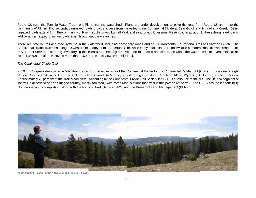
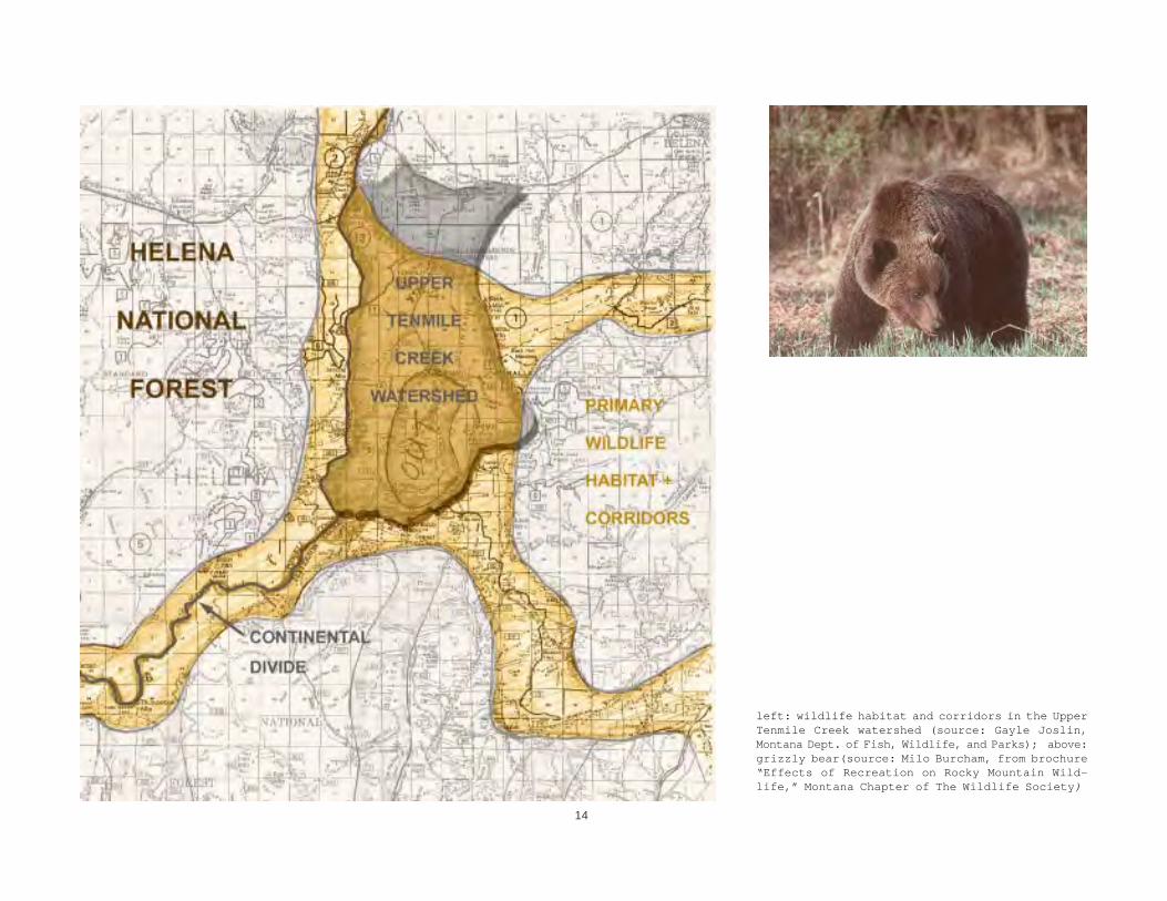
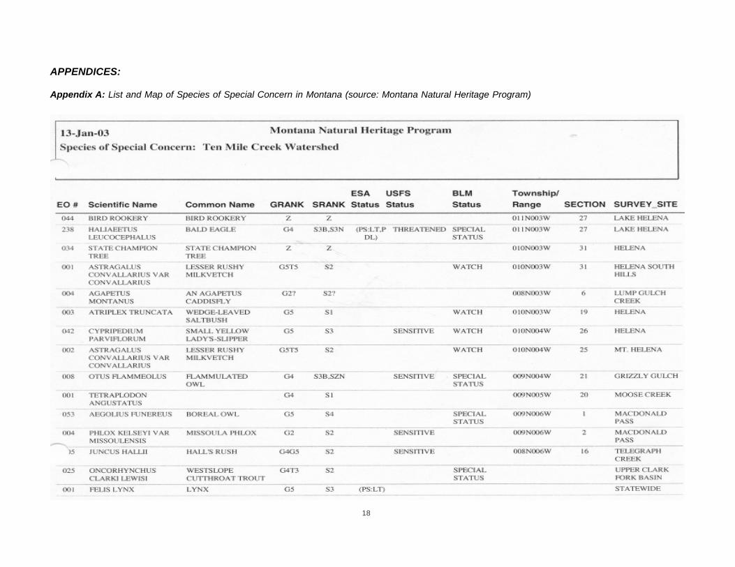
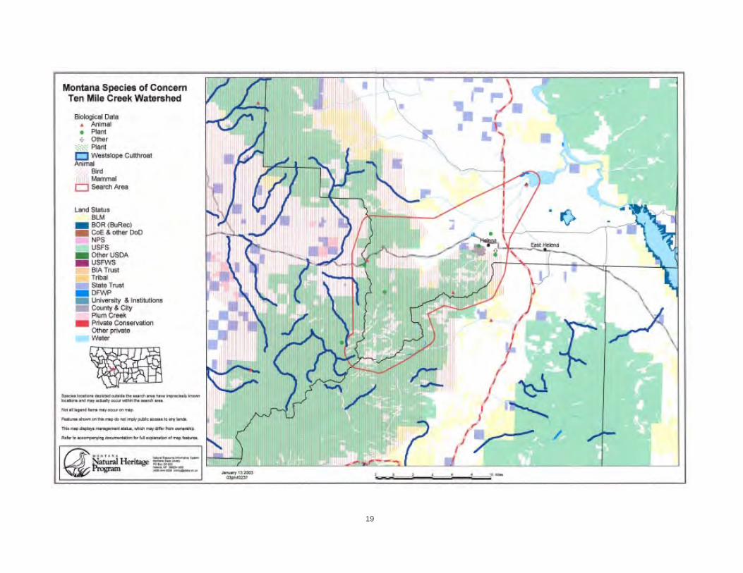
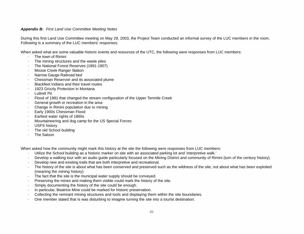
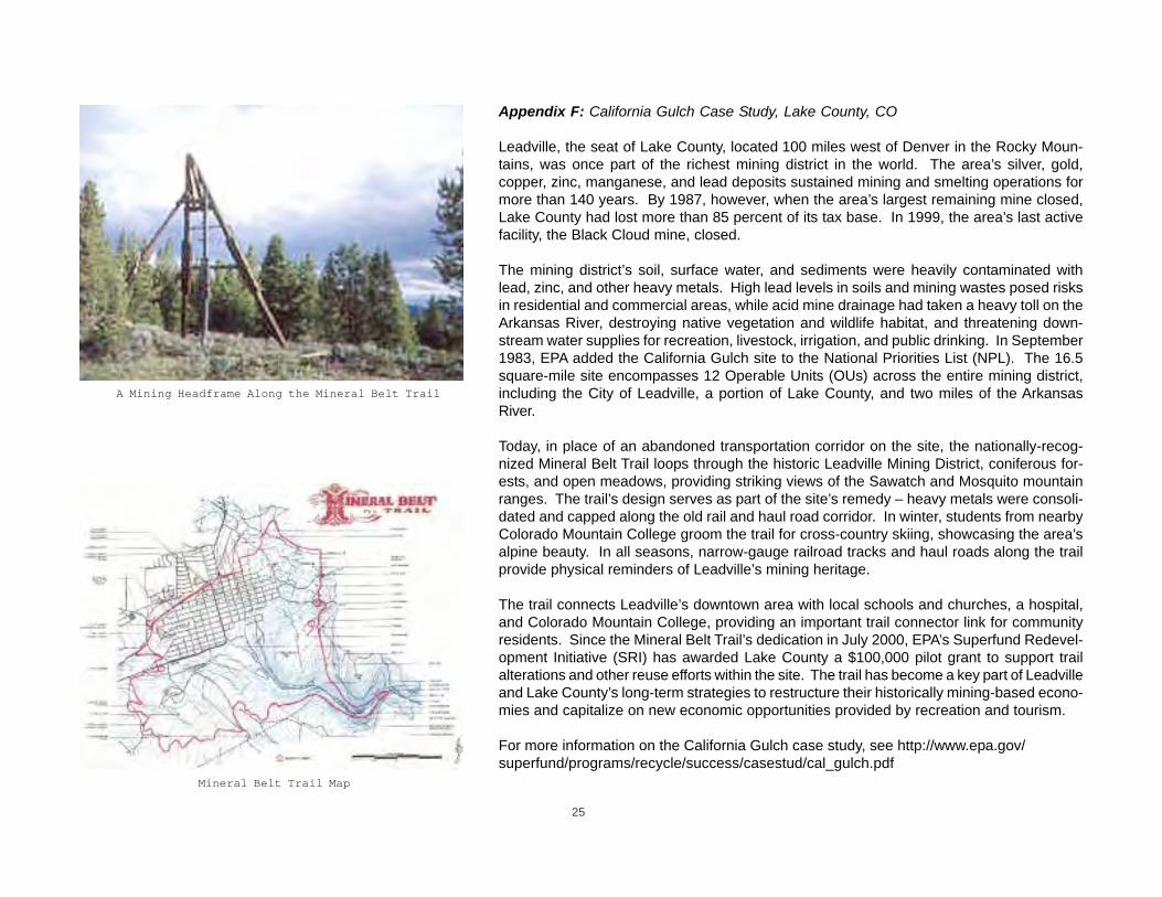

26
For more information contact
E2 Inc 2417 Northfield Road Charlottesville VA 22901 4349756700 - fax 4349756701 wwwe2inccom
27
For more information contact
E2 Inc 2417 Northfield Road Charlottesville VA 22901 4349756700 - fax 4349756701 wwwe2inccom
27