Embed Size (px)
Citation preview

Utility Assessment Package
For
Project Development and Environment (PD&E) Study Re-Evaluation
Osceola Parkway Extension
Orange and Osceola Counties, Florida
CFX Project No. 599-223
Prepared For:
Central Florida Expressway Authority
4974 ORL Tower Road
Orlando, FL 32807
April 2019

Utility Assessment Package for PD&E Study Re-evaluation 2
CFX Project No. 599-223
Table of Contents Introduction .................................................................................................................................................. 4
Purpose ......................................................................................................................................................... 4
Existing Roadway Facilities ........................................................................................................................... 5
SR 417 from Boggy Creek Road to Lake Nona Boulevard (Orange County): ............................................ 5
Boggy Creek Road from Simpson Road to SR 417 (Orange County): ........................................................ 5
Boggy Creek Road from Tindall Access Road to Narcoossee Road (Osceola County): ............................. 5
Simpson Road from Osceola Parkway to Boggy Creek Road (Osceola County): ...................................... 5
Lake Nona Boulevard from Boggy Creek Road to Medical City Drive (Orange County): .......................... 5
Narcoossee Road from Sanctuary Crossing Road to Clapp Simms Duda Road (Orange County): ............ 5
Clapp Simms Duda Road from Narcoossee Road to C-29A Canal (Orange County): ................................ 6
Cyrils Drive from Franklin Road to Absher Road (Osceola County): ......................................................... 6
Absher Road from 1/4 mile South of Cyrils Drive to Cyrils Drive (Osceola County): ................................ 6
Sungrove Lane (Osceola County): ............................................................................................................. 6
Other Local Roads (Orange County): ........................................................................................................ 6
Proposed Roadway Improvements ............................................................................................................... 7
Project Description.................................................................................................................................... 7
Proposed Typical Sections ........................................................................................................................ 7
Roadway Alternatives ............................................................................................................................... 8
Lake Nona Alternative ........................................................................................................................... 8
Boggy Creek Alternative ........................................................................................................................ 8
Split Oak Avoidance Minimization Alternative ..................................................................................... 8
Split Oak Avoidance Alternative ........................................................................................................... 8
Existing Utility Agency Owner (UAO) Assessment ........................................................................................ 9
Findings and Results .................................................................................................................................... 11
Utility Mitigation and Cost .......................................................................................................................... 14

Utility Assessment Package for PD&E Study Re-evaluation 3
CFX Project No. 599-223
List of Figures
Figure 1 - Project Location Map .................................................................................................................... 4
Figure 2 - Proposed OPE Typical Section ...................................................................................................... 7
Figure 3 - Proposed Alternatives ................................................................................................................... 9
List of Tables
Table 1 - List of Contact Information .......................................................................................................... 10
Table 2 – Utility Assessment and Estimated Relocation Cost ................................................................ 12,13
Table 3 - Summary of Utility Impacts .......................................................................................................... 14
Appendices
Appendix A Utility Contact Letters & Responses
Appendix B Utility Assessment Package, September 2016
Appendix C PD&E Project Recommended Alternative Plan Sheets (to be provided by RS&H)
Appendix D Sunshine 811 Design Ticket
Appendix E Utility Contact Log

Utility Assessment Package for PD&E Study Re-evaluation 4
CFX Project No. 599-223
Introduction A Utility Assessment Package was developed in September 2016 as part of the Osceola Parkway
Extension (OPE) PD&E Study (FDOT FPID 432134-1-22-01 & FPID 432134-2-22-01) for the Osceola
County Expressway Authority. The PD&E Study addressed new roadway capacity, east of Osceola
Parkway to the proposed Northeast Connector Expressway, a 2-mile extension east of the Northeast
Connector Expressway, as well as an expressway connection to SR 417 in the vicinity of the existing
Boggy Creek Road interchange with SR 417 in Orange and Osceola Counties, Florida. A re-evaluation
of the previous PD&E Study is underway, including the previous Utility Assessment Package. This
Utility Assessment Package will look to expand on the previous study’s findings, as well as identify
additional Utility Agency Owner (UAO) information for revised corridor alternatives not evaluated in
the previous study. The Osceola Parkway Extension (OPE) is approximately 12 miles in length. See
Appendix B for the previous study along with source material. Figure 1 shows the Osceola Parkway
Extension Study Area.
Figure 1 - Project Location Map
Purpose This Utility Assessment Package has been assembled to provide information on existing and planned
utilities within the study limits. This package contains information on the names of utility companies,
aerials denoting the location of major existing and proposed facilities, descriptions of the identified
utilities, project coordination efforts, potential impacts, and information on the cost of relocation.
This assessment also re-evaluates the 2016 Utility Assessment Package’s findings with those made
from this study’s coordination effort.

Utility Assessment Package for PD&E Study Re-evaluation 5
CFX Project No. 599-223
Existing Roadway Facilities There is a mixture of functionally classified roadways within the project study area. Listed below are
the roadway sections within the project study area affected by the different corridor alternatives as
well as a description of their typical section. Existing and future geometry and other measurements
are based on the previous study’s (2016) assessment, unless otherwise noted.
SR 417 from Boggy Creek Road to Lake Nona Boulevard (Orange County):
SR 417 is a four-lane divided, limited access facility consisting of 12-foot-wide travel lanes separated
by a 64-foot-wide grassed median. The inside shoulders are eight feet wide with four feet of
pavement. The outside shoulders are 12-foot wide with ten feet of pavement. The limited access right-
of-way width is 300 feet. Drainage is conveyed by roadside swales to stormwater ponds. The typical
section was developed to allow for future inside widening to six lanes with a 40-foot grassed median.
Boggy Creek Road from Simpson Road to SR 417 (Orange County):
Boggy Creek Road is a two-lane undivided, rural roadway which has been widened to multiple lanes
through, or approaching, its intersections with SR 417, Lake Nona Boulevard, and Simpson Road.
Orange County has plans to widen Boggy Creek Road to four lanes from Simpson Road to Lake Nona
Boulevard.
Boggy Creek Road from Tindall Access Road to Narcoossee Road (Osceola County):
Boggy Creek Road is a two-lane undivided, rural roadway that has been widened to multiple lanes
approaching its intersection with Narcoossee Road. Based on January 2018 Google Earth Imagery, the
road consists of 11-foot travel lanes. In addition, there appears to be construction work to widen the
road to the North between Tindall Access Road and Rustic Drive.
Simpson Road from Osceola Parkway to Boggy Creek Road (Osceola County):
Simpson Road is a two-lane undivided rural roadway consisting of 12-foot lanes. The road has been
widened to multiple lanes through, or approaching, its intersections with Osceola Parkway and Boggy
Creek Road. Osceola County has prepared plans to widen Simpson Road to four 12-foot lanes with a
median ranging from 34 to 46 feet.
Lake Nona Boulevard from Boggy Creek Road to Medical City Drive (Orange County):
Lake Nona Boulevard is currently a four-lane divided, urban roadway in Orange County. Based on
January 2018 Google imagery, the road consists of 11-foot travel lanes, 4-foot bike lanes, and a 48-
foot median with curb and gutter. Other features include a 5-foot concrete sidewalk on the south
side, and an 11-foot asphalt shared-use path on the north side.
Narcoossee Road from Sanctuary Crossing Road to Clapp Simms Duda Road (Orange
County):
Narcoossee Road is a six-lane divided urban roadway from SR 417 to the Osceola County line. The
typical section includes six 11-foot lanes, four-foot bike lanes in each direction, and a 17-foot median.
Utility Assessment Package for PD&E Study Re-evaluation 6
CFX Project No. 599-223
Clapp Simms Duda Road from Narcoossee Road to C-29A Canal (Orange County):
Clapp Simms Duda Road is a two-lane undivided roadway in Orange County. Based on January 2018
Google Earth Imagery, the road consists of 11-foot travel lanes.
Cyrils Drive from Franklin Road to Absher Road (Osceola County):
Cyrils Drive is a two-lane undivided roadway in Osceola County. Based on January 2018 Google Earth
Imagery, the road consists of 10-foot travel lanes.
Absher Road from 1/4 mile South of Cyrils Drive to Cyrils Drive (Osceola County):
Absher Road is a two-lane undivided roadway in Osceola County. Based on January 2018 Google Earth
Imagery, the road consists of 10-foot travel lanes.
Sungrove Lane (Osceola County):
Based on January 2018 Google Earth Imagery, Sungrove Lane is an unmarked, unpaved roadway in
rural Osceola County.
Other Local Roads (Orange County):
There are several local roads in Orange County within the project study area that are found within
residential areas east of Boggy Creek Road. These roadways are New Hope Road, Beth Road,
Whispering Pines Road, Happy Lane, Bicky Road, Hidden Trail Road, and a gated, private road
intersecting Boggy Creek Road. The typical section for these roadways are similar in that they are all
two-lane undivided, unmarked paved sections varying from 20 to 24 feet widths (based on January
2018 Google Earth Imagery).
Utility Assessment Package for PD&E Study Re-evaluation 7
CFX Project No. 599-223
Proposed Roadway Improvements
Project Description
The Central Florida Expressway Authority (CFX) is studying a new expressway connection between
State Road 417 near Boggy Creek Road in Orange County and the proposed Sunbridge Parkway in
Osceola County. Figure 1 shows the Osceola Parkway Extension (OPE) Study Area.
The project alternatives for the project area split into two sections:
• SR 417 to Narcoossee Road; and
• Narcoossee Road to Sunbridge Parkway.
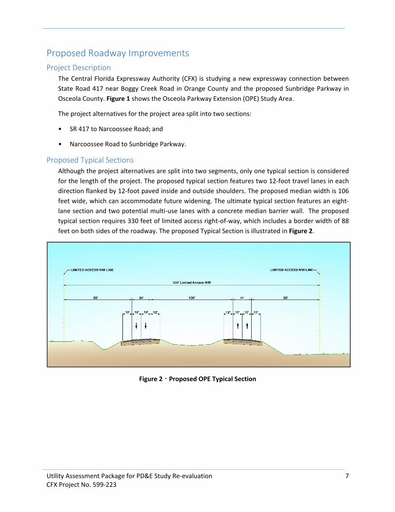
Proposed Typical Sections
Although the project alternatives are split into two segments, only one typical section is considered
for the length of the project. The proposed typical section features two 12-foot travel lanes in each
direction flanked by 12-foot paved inside and outside shoulders. The proposed median width is 106
feet wide, which can accommodate future widening. The ultimate typical section features an eight-
lane section and two potential multi-use lanes with a concrete median barrier wall. The proposed
typical section requires 330 feet of limited access right-of-way, which includes a border width of 88
feet on both sides of the roadway. The proposed Typical Section is illustrated in Figure 2.
Figure 2 - Proposed OPE Typical Section
Utility Assessment Package for PD&E Study Re-evaluation 8
CFX Project No. 599-223
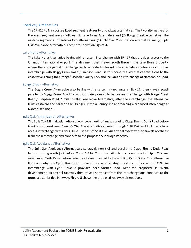
Roadway Alternatives
The SR 417 to Narcoossee Road segment features two roadway alternatives. The two alternatives for
the west segment are as follows: (1) Lake Nona Alternative and (2) Boggy Creek Alternative. The
eastern segment also features two alternatives: (1) Split Oak Minimization Alternative and (2) Split
Oak Avoidance Alternative. These are shown on Figure 3.
Lake Nona Alternative
The Lake Nona Alternative begins with a system interchange with SR 417 that provides access to the
Orlando International Airport. The alignment then travels south through the Lake Nona property,
where there is a partial interchange with Laureate Boulevard. The alternative continues south to an
interchange with Boggy Creek Road / Simpson Road. At this point, the alternative transitions to the
east, travels along the Orange/ Osceola County line, and includes an interchange at Narcoossee Road.
Boggy Creek Alternative
The Boggy Creek Alternative also begins with a system interchange at SR 417, then travels south
parallel to Boggy Creek Road for approximately one-mile before an interchange with Boggy Creek
Road / Simpson Road. Similar to the Lake Nona Alternative, after the interchange, the alternative
turns eastward and parallels the Orange/ Osceola County line approaching a proposed interchange at
Narcoossee Road.
Split Oak Minimization Alternative
The Split Oak Minimization Alternative travels north of and parallel to Clapp Simms Duda Road before
turning southeast near Canal C-29A. The alternative crosses through Split Oak and includes a local
access interchange with Cyrils Drive just east of Split Oak. An arterial roadway then travels northeast
from the interchange and connects to the proposed Sunbridge Parkway.
Split Oak Avoidance Alternative
The Split Oak Avoidance Alternative also travels north of and parallel to Clapp Simms Duda Road
before turning south just before Canal C-29A. This alternative is positioned west of Split Oak and
overpasses Cyrils Drive before being positioned parallel to the existing Cyrils Drive. This alternative
then re-configures Cyrils Drive into a pair of one-way frontage roads on either side of OPE. An
interchange with Cyrils Drive is provided near Absher Road. Near the proposed Del Webb
development, an arterial roadway then travels northeast from the interchange and connects to the
proposed Sunbridge Parkway. Figure 3 shows the proposed roadway alternatives.

Utility Assessment Package for PD&E Study Re-evaluation 9
CFX Project No. 599-223
Figure 3 - Proposed Alternatives
Existing Utility Agency Owner (UAO) Assessment The UAOs in the study area were determined using a variety of sources. First, a Sunshine 811 Design
Ticket was made to identify the utility providers and operators registered with the service. Next, the
utility providers and operators were contacted to establish the proper personnel to assist with
locating and identifying existing facilities. Lastly, conceptual plans and alternatives were sent for
review to the previously mentioned personnel. Based on these conceptual plans, they were asked to
provide mark-ups, descriptions, and/ or maps depicting the locations and types of utilities within their
facilities. In addition, each UAO was requested to provide rough cost estimates for relocating existing
facilities, as well as notification of future planned facilities or upgrades to existing facilities within the
project study area. The UAOs identified on the project are summarized in Table 1. The responses from
the UAOs are provided in Appendix A. A contact log was developed to record and keep track of
coordination efforts with the UAOs; see Appendix E.
Twenty-four UAOs were identified within the study limits based on the Sunshine 811 Design Ticket
(provided in Appendix D). In addition, there were two UAOs listed in the previous study (2016) that
were not identified in the Sunshine 811 Design Ticket developed for this current assessment. This
resulted in a total of twenty-six UAOs evaluated for this study. Of the twenty-six UAOs identified,
contacts for six could not be established based on the preliminary contact information. Further
coordination efforts will continue in order to confirm if the providers have facilities within the project
study area.

Utility Assessment Package for PD&E Study Re-evaluation 10
CFX Project No. 599-223
Table 1 List of Utility Contact Information
AT&T Distribution Alan [email protected]
407-351-8180
Aerial & buried cables
Telephone
Charter
Communications
Ronald Tynes [email protected]
407-532-8509
Aerial & buried cables
Fiber, Telephone, CATV
CFXJonathan Will iamson jwill [email protected]
321-354-9614
Fiber
Century LinkMarlon Brown [email protected]
407-814-5293
Fiber, Telephone
City of St. CloudRick Mauro [email protected]
407-957-7341
Reclaimed Water, Water, Sewer
City of Orlando
Water Reclamation
David Breitrick [email protected]
407-246-3525
Reclaimed Water, Wastewater
City of Orlando
Traffic Eng Signal
Fiber Electric
Benton Bonney ---
407-246-2636
Fiber, Traffic signals, electric
ComcastCesar Rivera [email protected]
---
CATV
Duke Energy
Distribution
Stephanie Olmo [email protected]
407-905-3376
Distributed Electric
Duke Energy
Transmission
Jennifer Will iams [email protected]
813-909-1210
Transmission
Embarq
Communications Inc.
Robert Godek [email protected]
407-830-3421
Fiber
Hotwire
Communications
Walter Davila walter.sancho-
954-699-0900
Fiber, Telephone, CATV
MCIDean Boyers ---
469-886-4238
Fiber, Communication Lines
Orlando Telephone
Company
Corey Lassonde [email protected]
407-996-6297
Fiber, Telephone
Orlando Util ities
Commision - Electric
407-434-2563
Distributed Electric
Orlando Util ities
Commision -
Transmission
407-434-2563
Transmission
Orlando Util ities
Commision -Water
407-434-2563
Water
Orange County
Util ities Wastewater
David Shorette [email protected]
407-254-9764
Wastewater
Orange County Public
Works
Roger Smith [email protected]
407-836-7804
Fiber, Traffic Signals
Orange County
Util ities Water
Guy Jackson ---
305-988-7646
Water
Osceola CountyJack Lott [email protected]
407-742-7534
Fiber, Traffic Signals
SprintJon Baker [email protected]
352-409-5095
Buried Fiber
Summit BroadbandMichelle Daniel [email protected]
407-996-1183
Buried Fiber
Teco Peoples Gas -
Orlando
Joan Domning [email protected]
813-275-3783
Gas
Toho Water AuthorityMike Pampouk [email protected]
407-944-5000
Water, Sewer
UNITI Fiber LLCD J McAuley ---
251-259-0807
Fiber
Notes:
1. "---" Contact information could not be established or confirmed based on preliminary coordination efforts
Utility Owner Contact Email/ Phone FACILITIES
Utility Assessment Package for PD&E Study Re-evaluation 11
CFX Project No. 599-223
Findings and Results Table 2, on pages 12 and 13, presents a comparison of utility information collected as part of this
assessment, as well as utility information presented in the previous study (2016). As previously
mentioned, twenty-six UAOs were identified within the project study area as part of this assessment.
Of the twenty-six UAOs identified, thirteen UAOs have confirmed contact persons and provided
information regarding their facilities. Seven UAOs confirmed contact persons, however no utility
information has been received from these contacts. The remaining six UAOs have not confirmed
contact persons and no information has been received.
Coordination results for the twenty-six UAOs were compared to the findings obtained from the
previous study (2016). Thirteen UAOs were common to both assessments. Of these thirteen UAOs,
six have common findings in both studies, one (Sprint) had different findings based on the
correspondence, and six could not be corroborated due to lack of response from the UAO in one or
both of the studies. See Table 2 for a more detailed assessment of the UAOs.
Sprint was the UAO with different findings based on the correspondence from each assessment. It
was determined in the previous study (2016) that Sprint had buried fiber along the east side of Boggy
Creek Road (Orange County). However, this current study received a letter of no conflict from Sprint.
Further evaluation will need to be done in the subsequent phase of the project to determine if Sprint’s
facilities are still present.
Eleven additional UAOs were identified in the current study that were not listed in the previous study
(2016). Of these eleven, four have confirmed facilities within the project study area, and the other
seven have either not responded or preliminary contact could not be established.
Two UAOs were identified in the previous study (2016), but not in the current study. Per the previous
study (2016), one UAO (Duke Energy Transmission) responded with no facilities within the project
study area, and the other UAO (Summit Broadband) identified buried facilities along Boggy Creek
Road. Information has yet to be received from these two UAOs for this current assessment. Further
evaluation will need to be done in the subsequent phase of the project to determine if the previous
study facilities are still present.
Future development sites were identified in Orange County. A future development within the Lake
Nona Alternative, between SR 417 and Lake Nona Boulevard, was identified. Another future
development known as Poitras Property from south of Laureate Park to the Orange/ Osceola County
line are within the Lake Nona Alternative. The City of Orlando has expressed future planned utilities
(water/ sanitary) in these areas, and has provided service maps identifying their service area
boundaries within this future development.

Table 2 Utility Assessment and Estimated Relocation Cost
UAO Assessment/ Evaluation (Current)Relocation Cost
(Current)
Assessment/ Evaluation
(Utility Assessment Package, Sept. 2016)
Relocation Cost
(2016)
AT&T Distribution
Buried and aerial facilities are present along Boggy Creek Road from north of SR 417 to
Simpson Road, New Hope Road from Boggy Creek Road to cul-de-sac, Simpson Road, and
Narcoossee Road. Aerial facilities are present along several local roads; Happy Lane, Bicky
Road, Hidden Trail Road, Beth Road, Whispering Pines Road, and Beacon Park Boulevard.
Buried facilities are present along Lake Nona Boulevard from north of SR 417 to just south of
the SR 417 interchange, Boggy Creek Road (Osceola County), and Clapp Simms Duda Road.
TBD
FOC along the west side of Boggy Creek Rd. and copper BT along the east side of Boggy Creek
Rd. Aerial FOC on the west side of Narcoossee Rd. and aerial copper along the east side of
Narcoossee Rd. Buried copper along the south side of Clapp Simms Duda Rd.
$220,000
Charter
Communications
Buried and aerial facilities are present along Boggy Creek Road from north of SR 417 to
Simpson Road, as well as along the local roads adjacent to Boggy Creek (Orange County) in
both the east and west directions. These utilities span the entirety of the residential
communities east of Boggy Creek Road. Buried and aerial facilities were also identified along
Lake Nona Boulevard and Narcoossee Road.
TBD
(f.k.a Bright House Networks) Aerial and buried facilities along the west side of Boggy Creek
Road. Aerial facilities along the east side of Narcoossee Rd and buried facilities along the west
side of Narcoossee Rd.$60,000
CFX Buried facilities are present along the roadside slope on both sides of SR 417 including along
the ramps at both the Boggy Creek Road and Lake Nona Boulevard Interchanges. TBD
Not identified/ evaluated.
N/A
Century Link
Buried facilities are present along Boggy Creek Road from Lake Nona Boulevard to Simpson
Road, Lake Nona Boulevard, Boggy Creek Road (Osceola County), Narcoossee Road (Osceola
County), Cyrils Drive, and Absher Road.
TBD
No Response
TBD
City of St. Cloud No facilities within Project Limits. $0 No Facilities $0
City of Orlando
Water Reclamation
Reclaimed and sanitary service areas are located in Orange County and border east of Hidden
Trail Road and west of Narcoossee Road. Reclaimed and sanitary service lines are present
along all sides of Lake Nona Boulevard, and on the N/W side of SR 417 from Boggy Creek
Road to Lake Nona Boulevard.
Future planned utilities and development between SR 417 and Lake Nona Boulevard.
Future planned utilities and development through a collection of properties known as the
Poitras Property (county line to south of Laureate Park)
TBD
Not identified/ evaluated.
N/A
City of Orlando
Traffic Eng Signal
Fiber Electric
Could not establish contact based on Sunshine 811 Design Ticket information.
TBD
Not identified/ evaluated.
N/A
Comcast
Buried and aerial facilities are present along the east and west side of Boggy Creek Road from
north of SR 417 to south of Simpson Road, south side of Simpson Road from Boggy Creek
Road to Osceola Parkway, and south side of Boggy Creek Road (Osceola County).$754,240.56
Buried fiber optic lines located along the west side of Boggy Creek Rd. starting from SR 417 to
just south of New Hope Rd. where transitions to the east side of the road and continues to
Simpson Rd.$20,000
Duke Energy
Distribution
No ResponseTBD
Overhead and underground distribution electric along the west side of Boggy Creek Rd.$30,000
Duke Energy
Transmission
Not identified in Sunshine 811 Design Ticket.N/A
No Facilities$0
12

Table 2 Utility Assessment and Estimated Relocation Cost
UAO Assessment/ Evaluation (Current)Relocation Cost
(Current)
Assessment/ Evaluation
(Utility Assessment Package, Sept. 2016)
Relocation Cost
(2016)
Embarq
Communications Inc.
Buried facilities were present along the south side of Boggy Creek Road (Osceola County).
Embarq Communications Inc. (ECI) are under the umbrella of Century Link. Utility locates
from Century Link identify ECI locates (same utility locate contractor used in Terra Tech).TBD
Not identified/ evaluated.
N/A
Hotwire
Communications
No facilities within Project Limits.$0
No ResponseTBD
MCI Could not establish contact based on Sunshine 811 Design Ticket information. TBD Not identified/ evaluated. N/A
Orlando Telephone
Company
No ResponseTBD
No ResponseTBD
Orlando Utilities
Commision - Electric
No Response
TBD
Orlando Utilities
Commision -
Transmission
No Response
TBD
Orlando Utilities
Commision - Water
No ResponseTBD
Not identified/ evaluated.N/A
Orange County
Utilities
Wastewater
No Response
TBD
Not identified/ evaluated.
N/A
Orange County Public
Works
No ResponseTBD
Not identified/ evaluated.N/A
Orange County
Utilties Water
Could not establish contact based on Sunshine 811 Design Ticket information.TBD
Not identified/ evaluated.N/A
Osceola CountyBuried and aerial facilities (signalization) present at intersection of Boggy Creek Road and
Simpson Road.TBD
Signal equipment located at the intersection of Simpson Rd. and Boggy Creek Rd.$400,000
SprintNo facilities within Project Limits.
$0FOC along the north side of Boggy Creek Rd. FOC along the west side of Narcoossee Rd.
$20,000
Summit Broadband Not identified in Sunshine 811 Design Ticket. N/A Buried FOC along the east side of Boggy Creek Rd. $20,000
Teco Peoples Gas -
Orlando
Gasline present on S/E side of SR 417 between Boggy Creek Road and Lake Nona Boulevard
Interchange, and on Lake Nona Boulevard at and east of Medical City Drive intersection.$247 per
Linear Foot
Not identified/ evaluated.
N/A
Toho Water Authority
Water main present along north side of Simpson Road, and south of intersection at Boggy
Creek Road (Osceola County) on the east side. Force main present along south side of
Simpson Road, and south of intersection at Boggy Creek Road (Osceola County) on the west
side. Water main present along Boggy Creek Road (Osceola County) on north side, and force
main present along Boggy Creek Road (Osceola County) on the south side. Water main
present along the south side of Cyrils Drive.
TBD
16” water main (dry line) and 16” force main at the intersection of Simpson Road and Boggy
Creek Rd.
$75,000
UNITI Fiber LLC Could not establish contact based on Sunshine 811 Design Ticket information. TBD Not identified/ evaluated. N/A
Transmission and distribution electric along the east side of Narcoossee Rd. and distribution
electric along the south side of Clapp Simms Duda Rd.
$220,000
13

Utility Assessment Package for PD&E Study Re-evaluation 14
CFX Project No. 599-223
Utility Mitigation and Cost Due to the nature of the existing conditions throughout the project corridor, it is anticipated that the
Osceola Parkway Extension will impact a number of the existing utility facilities on the project. Table
3 provides a summary of the UAOs impacted per corridor alternative. The project’s extents,
anticipated right-of-way acquisition, and related improvements are shown on the recommended
alternative conceptual plans included in Appendix C. Since survey was not performed as a part of this
evaluation study, UAOs could not provide an estimated schedule for performing their relocations
without knowing the extent of the actual impacts. Mitigation measures should be taken during the
design phase of the project to minimize impacts to the existing utilities to the fullest extent possible.
If impacts are unavoidable, design alternatives should be reviewed to allow for relocation of impacted
facilities in a manner that minimizes cost to the UAO and disruption to their customers.
Table 2 - Summary of Utility Impacts
Lake Nona Boggy Creek
Split Oak
Minimization
Split Oak
Avoidance
AT&T Distribution X X X X
Charter Communications X X X X
CFX X --- --- ---
Century Link X X --- X
City of Orlando Water Reclamation X X --- ---
Comcast X X --- ---
Duke Energy Distribution --- X --- ---
Embarq Communications Inc. --- --- --- ---
Orlando Utilities Commission - Electric --- --- X X
Orlando Utilities Commission - Transmission --- --- X X
Osceola County X X --- ---
Sprint --- --- X X
Summit Broadband --- X --- ---
Teco Peoples Gas - Orlando X --- --- ---
Toho Water Authority X X --- X
Legend:
"X" Depicts one or more impacted UAO facilities
"---" Depicts no utility facilities impacted
Utility Agency Owner (UAO)
Corridor Alternatives
West Segment East Segment