Embed Size (px)
Citation preview
UTILITIES DEPARTMENT
SURFACE WATER ENGINEERING STANDARDS
August 1998

SURFACE WATER ENGINEERING STANDARDS
TABLE OF CONTENTS CHAPTER Dl - GENERAL REQUIREMENTS
D1-01 GENERAL .................................................................................................. D1-1 D1-02 DEFINITIONS ............................................................................................ D1-1 D1-03 REFERENCES ............................................................................................ D1-3 D1-04 GOVERNMENTAL AGENCY REQUIREMENTS .................................. D1-4
CHAPTER D2 - PLAN SUBMITTAL
D2-01 GENERAL .................................................................................................. D2-1 D2-02 DEVIATIONS............................................................................................. D2-1 D2-03 ERRORS AND OMISSIONS ..................................................................... D2-1 D2-04 DESIGN CALCULATIONS....................................................................... D2-2 D2-05 PLANS ........................................................................................................ D2-2 D2-06 OTHER SUBMITTALS.............................................................................. D2-5 D2-07 AS-BUILTS DOCUMENTATION............................................................. D2-5
CHAPTER D3 -HYDROLOGIC ANALYSIS
D3-01 GENERAL .................................................................................................. D3-1 D3-02 DESIGN STORMS ..................................................................................... D3-2 D3-03 HYDROLOGIC MODELS ......................................................................... D3-6 D3-04 TIME OF CONCENTRATION CALCULATIONS................................... D3-6 D3-05 CURVE NUMBERS ................................................................................... D3-6 D3-06 SOIL TYPES ............................................................................................... D3-6

D3-07 MINIMUM IMPERVIOUS AREAS .......................................................... D3-7 D3-08 RATIONAL METHOD............................................................................... D3-7 D3-09 PIPE SYSTEM ANALYSIS AND SIZING.............................................. D3-12
CHAPTER D4 – HYDRAULIC ANALYSIS & DESIGN D4-01 GENERAL .................................................................................................. D4-1 D4-02 DISCHARGE LOCATIONS....................................................................... D4-1 D4-03 OFF-SITE CAPACITY ANALYSIS .......................................................... D4-2 D4-04 CONVEYANCE SYSTEMS....................................................................... D4-4 D4-05 MANHOLES, CATCHBASINS AND INLETS....................................... D4-16 D4-06 RUNOFF CONTROL................................................................................ D4-18 D4-07 EASEMENT REQUIREMENTS.............................................................. D4-35
CHAPTER D5 – WATER QUALITY BEST MANAGEMENT PRACTICES D5-01 GENERAL .................................................................................................. D5-1 D5-02 SOURCE CONTROL BMPs....................................................................... D5-1 D5-03 RUNOFF TREATMENT BMPs ................................................................. D5-3 D5-04 OFF-SITE WATER QUALITY ANALYSIS/MITIGATION .................... D5-8 D5-05 OPERATION AND MAINTENANCE SCHEDULE FOR BMPs AND
FACILITIES ............................................................................................... D5-8
CHAPTER D6 - NATURAL SYSTEMS D6-01 GENERAL .................................................................................................. D6-1 D6-02 STREAMS................................................................................................... D6-1 D6-03 WETLANDS ............................................................................................... D6-2

CHAPTER D7 - MATERIALS D7-01 GENERAL .................................................................................................. D7-1 D7-02 CONVEYANCE SYSTEMS....................................................................... D7-1 D7-03 MANHOLES, CATCHBASINS, AND INLETS........................................ D7-5 D7-04 RUNOFF CONTROL - DETENTION FACILITIES ................................. D7-6 D7-05 RUNOFF CONTROL - INFILTRATION SYSTEMS ............................... D7-8
CHAPTER D8 - METHODS OF CONSTRUCTION D8-01 GENERAL .................................................................................................. D8-1 D8-02 CLEARANCE BETWEEN UTILITY LINES ............................................ D8-1 D8-03 CONNECTIONS/MODIFICATIONS TO PUBLIC DRAINAGE SYSTEM................................................................................ D8-1 D8-04 CONVEYANCE SYSTEMS....................................................................... D8-2 D8-05 MANHOLES, CATCH BASINS, & INLETS ............................................ D8-4 D8-06 RUNOFF CONTROL - DETENTION FACILITIES ................................. D8-5 D8-07 RUNOFF CONTROL - INFILTRATION SYSTEMS ............................... D8-6 D8-08 ABANDONING FACILITIES.................................................................... D8-6

SURFACE WATER ENGINEERING STANDARDS AUGUST 1998
APPENDIX APPENDIX D-1 STANDARD DETAILS ...........................................................................A(D1-1) APPENDIX D-2 SAMPLE TITLE BLOCK ........................................................................A(D2-1) APPENDIX D-3 DRAFTING STANDARDS .....................................................................A(D3-1)

SURFACE WATER ENGINEERING STANDARDS AUGUST 1998
CHAPTER D1 - GENERAL REQUIREMENTS
TABLE OF CONTENTS
D1-01 GENERAL .................................................................................................. D1-1 D1-02 DEFINITIONS ............................................................................................ D1-1 D1-03 REFERENCES ............................................................................................ D1-3 D1-04 GOVERNMENTAL AGENCY REQUIREMENTS .................................. D1-4
SURFACE WATER ENGINEERING STANDARDS AUGUST 1998
CHAPTER D1 - GENERAL REQUIREMENTS
Dl-01 GENERAL
D1-01.1 Purpose These Engineering Standards set forth the minimum standards for the planning, design, and construction of storm and surface water systems. The Storm and Surface Water Utility Code, part of Chapter 24.06 of the Bellevue City Code, adopted April 3, 1995, amended November 27, 1995, is the basis for these engineering standards. Although these standards are intended to apply to physical development within the City, the standards will not apply for all situations. Compliance with these standards does not relieve the Developer of the responsibility to apply conservative and sound professional judgment. These are minimum standards and are intended to assist, but not substitute for competent work by design professionals. The Utility may, at its sole discretion due to special conditions and/or environmental constraints, require more stringent requirements than would normally be required under these standards.
Dl-02 DEFINITIONS The following terms as used in this document shall be defined and interpreted as follows: "Contractor" The person, partnership, firm or corporation contracting to do the work under these Documents. The term shall also include the Contractor's agents, employees and subcontractors. "Details or Additional Drawings" All details or drawings prepared to further explain or amplify the Plans, or for the revision of the same, all as herein provided. “Developer” Any individual, company, partnership, joint venture, corporation, association, society or group that has made, or intends to make, application to the City for permission to construct a surface water system connection, or extension, to the City’s surface water system.
D1 - 1
SURFACE WATER ENGINEERING STANDARDS AUGUST 1998
“DOE Manual” “Stormwater Management Manual for the Puget Sound Basin – Technical Manual,” Washington State Department of Ecology, 1992 Edition. When referenced, drainage systems shall conform to the criteria set forth in the DOE Manual. Such criteria, unless modified herein, shall be the minimum standard which surface water systems must meet. “Equipment” The machinery, accessories, appurtenances and manufactured articles to be furnished and/or installed under the Project. “Material or Materials” These words shall be construed to embrace machinery, manufactured articles, materials of construction (fabricated or otherwise) and any other classes of material to be furnished in connection with the Project. “Or Equal” Any manufactured article, material, method, or work which, in the opinion of the City, is equally desirable or suitable for the purposes intended in these standards, as compared with similar articles specifically mentioned herein. “Plans” All approved drawings or reproductions of approved drawings made or to be made pertaining to the work provided for in the permit or Developer Extension Agreement. “Project” The structure, facility, system or improvement to be constructed in whole or in part. "Reference Specifications" Reference specifications shall mean the technical specifications of other agencies incorporated or referred to herein. "Standard Details" City of Bellevue Utilities Department Standard Detail drawings.
D1 - 2

SURFACE WATER ENGINEERING STANDARDS AUGUST 1998
"Standard Plans" "Standard Plans for Road and Bridge Construction," Washington State Department of Transportation and the American Public Works Association, 1994 edition, including all amendments as of January 1995. "Standard Specifications" "1998 Standard Specifications for Road, Bridge, and Municipal Construction", English edition, Washington State Department of Transportation and the American Public Works Association including all amendments. "Words and Phrases" Whenever the words, "as directed", "as required", "as permitted", or words of like effect are used, it shall be understood that the direction, requirement or permission of the City is intended. The words, "sufficient", "necessary", "proper", and the like shall mean sufficient, necessary or proper in the judgment of the City. The words, "approved", "acceptable", "satisfactory", or words of like import shall mean approved by or acceptable to the City. "Work" The work necessary to manufacture and deliver machinery, equipment and material and/or the furnishing of all labor, tools, material, equipment, construction equipment, working drawings, where required, and other, necessities for the construction or erection of the structures shown and called for in the plans, specifications and permit/Developer Extension Agreement, and the act of constructing or erecting said structures complete. Dl-03 REFERENCES
"Flood Insurance Study - King County, Washington and Incorporated Areas," National Flood Insurance Program, Federal Emergency Management Agency (FEMA), current edition.
Hydraulic Code Rules, Chapter 220 - 110, Washington Administrative Code. Land Use Code (LUC), Bellevue City Codes, current edition. "Dam Safety Guidelines," Dam Safety Division, Washington State Department of Ecology, current edition. "Soil Survey - King County Area, Washington," Soil Conservation Service, U. S. Department of Agriculture. "Surface Water Design Manual," King County, Washington, September 1, 1998.
D1 - 3

SURFACE WATER ENGINEERING STANDARDS AUGUST 1998
Wherever references are made to the standards, specifications, or other published data of the various national, regional, or local organizations, such organizations may be referred to by their acronym or abbreviation only. As a guide to the user, the following acronyms or abbreviations which may appear shall have the meanings indicated herein: AASHTO American Association of the State Highway and Transportation Officials. ANSI American National Standards Institute, Inc. WSDOT Washington State Department of Transportation APWA American Public Works Association ASTM American Society for Testing and Materials AWWA American Water Works Association DOH Department of Health WAC Washington Administrative Code RCW Revised Code of Washington Dl-04 GOVERNMENTAL AGENCY REQUIREMENTS All construction on City, County or State roads or right-of-way shall be done in accordance with the agency's standards and requirements and in accordance with the franchise and/or permit requirements. The Contractor is responsible to determine these requirements prior to construction. Where conflict exists between these Standards and permit requirements, the most stringent permit requirements shall take precedence.
D1 - 4
SURFACE WATER ENGINEERING STANDARDS AUGUST 1998
CHAPTER D2 - PLAN SUBMITTAL
TABLE OF CONTENTS CHAPTER D2 - PLAN SUBMITTAL
D2-01 GENERAL .................................................................................................. D2-1 D2-02 DEVIATIONS............................................................................................. D2-1 D2-03 ERRORS AND OMISSIONS ..................................................................... D2-1 D2-04 DESIGN CALCULATIONS....................................................................... D2-2 D2-05 PLANS ........................................................................................................ D2-2 D2-06 OTHER SUBMITTALS.............................................................................. D2-5 D2-07 AS-BUILTS DOCUMENTATION............................................................. D2-5
D2 - 1

SURFACE WATER ENGINEERING STANDARDS AUGUST 1998
CHAPTER D2 - PLAN SUBMITTAL D2-01 GENERAL Following these standards to design the stormwater system will help ensure a timely review of the proposed project and keep review costs to a minimum. A drainage system which includes unreasonable and intensive maintenance or operational requirements as determined by the City shall be rejected in favor of a drainage system which does not place undue burdens on the owner/operators of such system. D2-02 DEVIATIONS D2-02.1 General
The Applicant may propose a deviation from the Standards. A non-standard system may take longer to review resulting in increased processing costs. The Applicant acknowledges these risks when submitting a non-standard system for review.
D2-02.2 Deviation Criteria
Requests for deviations which are site or project specific, shall be provided in writing and reviewed by the Utilities Technical Committee (Engineering Team). The City's decision to grant, deny, or modify the proposed deviation shall be based upon evidence that the deviation request meets the following criteria: A. The change will achieve the intended result through a comparable or even
superior design; and B. The change will not adversely affect safety and/or operation; and C. The change will not adversely affect maintainability.
D2-03 ERRORS AND OMISSIONS Any errors or omissions in the approved plans or information used as a basis for such approvals may constitute grounds for withdrawal of any approvals and/or stoppage of any or all of the permitted work, as determined by the City. It shall be the responsibility of the Developer to show cause why such work should continue, and make such changes in plans that may be required by the City before the plans are re-approved.
D2 - 1

SURFACE WATER ENGINEERING STANDARDS AUGUST 1998
D2-04 DESIGN CALCULATIONS Design calculations for storm and surface water systems (i.e. conveyance, runoff control, runoff treatment) shall be submitted for review. These calculations, bearing the signature and stamp of the responsible Civil Engineer, shall also include a thorough list of assumptions used. D2-05 PLANS D2-05.1 General
Utility plans submitted for review shall meet the City's "Boundary & Topographic Survey" and "Site Plan B" requirements. Current copies of these requirements are available at the City Hall Permit Center. The Utilities representative at the Permit Center will determine which requirements, if any, are not applicable to the proposed project.
D2-05.2 Submittal Standards
Combining Plans - Water, sanitary sewer and storm drainage designs (complete plan and profile) shall be on separate plan sheets, although alignments of all Utilities shall be shown on each utility plan. Plan sets for all 3 Utilities can be combined for small projects. Designs for water and sewer can be combined on the same plan sheets if plan scale is 1”=10’, V=20’, or 1’"=30’. Contact the Utility representative in the Permit Center for approval to combine plans. Plan submittals shall include:
Title Block - Border and title block shall conform to standard City of Bellevue format. See Appendix D-2. Project Name, Section - Township - Range, and Site Address shall be included in title block (lower right hand comer). Engineering Plans - Plan, profile and detail sheet(s) for the proposed drainage system. Site Areas - Total area, Existing and Proposed Pervious and Impervious areas, areas within Native Growth Protection Easements (NGPE), etc. on the drainage plan sheet(s). Hydrologic and Hydraulic Data - Design volumes and allowable release/design discharge rates for runoff control and runoff treatment facilities shall be stated on the plans. Scale - Be consistent and indicate your scale on each sheet using a bar symbol (for Plan reproduction integrity). Drawings are to be in a scale of 1” = 10', 1” = 20’ or 1” = 30’ for combined utility plans. Drawings at 1” = 40’ or 1” = 50’ scale shall show
D2 - 2

SURFACE WATER ENGINEERING STANDARDS AUGUST 1998
utility plans on separate sheets. Architectural scales for utility drawings will not be accepted. If the scale results in more than three pages of plan sheets, a cover sheet showing the entire project site (at a smaller scale) shall be provided.
North Arrow - Include on all plan view drawings. Where possible, north arrow shall face up and/or to the right hand side of plan sheet. Datum - Show both horizontal (NAD-83-91) and vertical (NAVD 88) control points. Specify the benchmark to be used for vertical control during construction. For sites with FEMA-mapped floodplains, label the 100-year floodplain elevation with the NGVD29 and NAVD88 values. The survey of the site, for both design and as-builting, shall be accurately referenced to the Washington State Plane Coordinate System (NAD-83-91) by field ties to at least two City of Bellevue survey control network monuments. All elevations shall be referenced to the North American Vertical Datum of 1988 (NAVD 88). Information on the City of Bellevue survey control network is available by contacting the Transportation Department, Property Services Division, at (425) 452-6019. Vicinity Map - Include on the plan for each utility. The vicinity map covers the project site and surrounding streets and property within a minimum of 600' of the site. Copies of a city map can be made from the Street Atlas in the Self Help area of the Permit Center. Drawing Quality - The drawing should be easy to read, with all lines and letters dark enough to provide good contrast with the paper. Drafting Media - Plans sheets shall be on 24" x 36" or 22" x 34" mylar, matte on both sides. Drafting Standards - Plotting shall be on mylar with a non-smudging, ink or ink-like media. Pencil drawings (including corrections or alterations) shall not be accepted. Drafting standards/symbols shall conform to Washington State APWA Chapter CAD Standards. See Appendix D-3. Lettering shall be done with "Leroy-style" font (SIMPLEX font if using AutoCAD). Text identifying existing features shall be 0.08" in height (Leroy 80 template). Text identifying street names shall be 0.24" in height (Leroy 240 template). Text for instructions and call outs for proposed facilities shall be 0. 12" in height (Leroy 120 template). On plans with more than one sheet, stationing shall proceed from left to right or from bottom to top.
D2 - 3

SURFACE WATER ENGINEERING STANDARDS AUGUST 1998
Upon approval for construction, final plans shall be provided in digital format for as-builting and permanent record. The digital format shall be AutoCAD` Release 14 (or earlier) ".DWG" file on an MS-DOS formatted 3.5" floppy disk or Zip disks. The AutoCAD' files shall include all plans, profiles, notes, and details of the surface water improvements. Making Copies of Plans - Blueline or blackline prints and photocopies are acceptable. Brownline prints and microfilm copies of plans will not be accepted. Type of Paper for Plan Copies - Blueprint quality or standard drafting paper. Tissue paper, graph paper, posterboard, cardboard, and similar materials will not be accepted.
D2-05.3 Storm Drainage General Plan Notes
The following is a listing of General Notes that should be incorporated on the first drainage plan sheet. All the notes on the list may not pertain to every project. The Developer should include only those notes that are relevant to the project and may omit non-relevant notes. However, do not renumber the remaining General Notes. If additional notes are needed for specific aspects, they should be added after the General Notes.
Storm Drainage General Notes: 1. All work shall conform to the current edition of the City of Bellevue
Utilities Department Engineering Standards and the Developer Extension Agreement.
2. The locations of all existing utilities shown hereon have been established by
field survey or obtained from available records and should therefore be considered approximate only and not necessarily complete. It is the sole responsibility of the contractor to independently verify the accuracy of all utility locations shown, and to further discover and avoid any other utilities not shown hereon which may be affected by the implementation of this plan.
3. The footing drainage system and the roof downspout system shall not be
interconnected unless such connection is at least I foot below the footing drainage system and down slope of the building foundation.
4. Provide and maintain temporary sedimentation collection facilities to ensure that
sediment or other hazardous materials do not enter the storm drainage system. For all construction during the rainy season, downhill basins and inlets must be protected with catch basin inserts. Simply placing filter fabric under the grate is not acceptable.
D2 - 4

SURFACE WATER ENGINEERING STANDARDS AUGUST 1998
5. Prior to final inspection and acceptance of storm drainage work, pipes and storm drain structures shall be cleaned and flushed. Any obstructions to flow within the storm drain system, (such as rubble, mortar and wedged debris), shall be removed at the nearest structure. Wash water of any sort shall not be discharged to the storm drain system or surface waters.
6. Ends of each storm drain stub at the property line shall be capped and located with
an 8' long 2" x 4" board, embedded to the stub cap and extending at least 3 feet above grade, and marked permanently "STORM". A copper 12 ga. locate wire firmly attached. The stub depth shall be indicated on the marker.
7. All grates in roadways shall be ductile iron, bolt-locking, vaned grates per
the Standard Details. Structures in traffic lanes outside of the curbline which do not collect runoff shall be fitted with round, bolt-locking solid covers. Off-street structures which do not collect runoff shall be fitted with bolt-locking solid covers.
8. Vegetation/landscaping in the detention pond and/or drainage swale(s) are an
integral part of the runoff treatment system for the project. Such drainage facilities will not be accepted until planting is complete.
D2-06 OTHER SUBMITTALS When required by Section 26.04.130(A)4 of the Storm and Surface Water Utility Code, the Developer shall submit an implementation schedule for the entire site, in accordance with the Section 1-2.4.2 of the DOE Manual, detailing how the entire site will meet code requirements for runoff control, runoff treatment, wetland discharge and recharge, off-site analysis and mitigation, and stormwater facility operation and maintenance. D2-07 AS-BUILT DOCUMENTATION The Developer is required to prepare an "As-built" plan of storm water runoff control and runoff treatment ponds and bioswales that are constructed as part of their project. The Developer is responsible for providing as-built information for any drainage improvements, if those other constructed facilities deviate significantly from the design drawings. As-built Requirements for Ponds Prior to Utility acceptance of drainage improvements, an "As-built" plan shall be prepared by a professional land surveyor or engineer licensed in the State of Washington. Only those plan sheets associated with storm water runoff control and runoff treatment ponds and bioswales shall be revised and submitted by the Developer. The "As-built" plan shall include accurate locations, elevations, and sizes of all constructed runoff control and runoff treatment ponds, and bioswales including additional information as set forth below. This includes but is not limited to:
D2 - 5

SURFACE WATER ENGINEERING STANDARDS AUGUST 1998
Locations, topographic features, and dimensions of all runoff control and runoff treatment ponds and bioswales. Include bottom and top elevations, and in plan view include labeled contour lines at one-foot intervals. As-built revisions to any detail drawings that provide information associated with ponds and bioswales, such as cross-sections, pond or bioswale lining material specifications (e.g., grass, plantings, etc.), plan or profile views, etc. Location, type, and elevation at tops, inverts, and bottoms of any drainage system facilities adjacent to each pond, such as control structures, catch basins, etc. Location, length, slope, direction of flow, profile and material type of any pipe, ditch, or swale, flowing into or out of each pond. Up-to-date property lines, and all easements and tracts with King County recording numbers shown. Project Name, Section - Township - Range, and site address, plat names, project engineer, lot numbers, block numbers, and lot addresses. Street names and city boundaries. Building footprints on commercial and multi-family sites. Dimensions from Right-of-Way centerline or property line. Survey benchmarks, control monuments, and basis of bearing.
Notes and details about unusual situations and features.
"As-built" plans shall be submitted to the Utilities Department using the approved mylar plan set as the basis for the redlined "As-built" plans. An "As-built" plan set in digital format shall also be submitted. The digital format shall be AutoCAD Release 14 (or earlier) ".DWG" file on a MSDOS formatted 3.5" floppy disk or Zip disk. As-built documents (redlined approved mylar plan set) shall bear the as-built date, signature and stamp of the licensed Land Surveyor or Engineer preparing them.
D2 - 6

SURFACE WATER ENGINEERING STANDARDS AUGUST 1998
As-Built Requirements Where Constructed Facilities Significantly Deviate from Approved Plans The Utility shall be the sole judge of the level of deviation that will require the Developer to provide as-built information of drainage facilities other than ponds. The Developer shall provide the Utility Inspector with information necessary for the Utility to complete an "As-built" drawing of the drainage system. This information includes, but is not limited to:
Location, type, and elevation at tops, inverts, and bottoms of all inlets, manholes, catch basins, clean-outs, oil/water separators, control structures, vaults, and other structures. Location, length, slope, direction of flow, profile and material type of pipe installed. Location, length, direction of flow, and slope of all constructed open channels, ditches, swales, etc.
This information shall be surveyed and plotted in plan and profile views that include all base map features included on the approved plan mylar set. The profile view shall include the as constructed finished grade over each pipeline. The information shall also be provided in digital format. The digital format shall be AutoCAD Release 14 (or earlier) ".DWG" file on an MS-DOS formatted 3.5" floppy disk or Zip disk. As-built documents (redlined approved mylar plan set) shall bear the as-built date, signature and stamp of the licensed Land Surveyor or Engineer preparing them.
D2 - 7

SURFACE WATER ENGINEERING STANDARDS AUGUST 1998
CHAPTER D3 - HYDROLOGIC ANALYSIS
TABLE OF CONTENTS D3-01 GENERAL ................................................................................................... D3-1 D3-02 DESIGN STORMS ...................................................................................... D3-2 D3-03 HYDROLOGIC MODELS ......................................................................... D3-6 D3-04 TIME OF CONCENTRATION CALCULATIONS................................... D3-6 D3-05 CURVE NUMBERS ................................................................................... D3-6 D3-06 SOIL TYPES ............................................................................................... D3-6 D3-07 MINIMUM IMPERVIOUS AREAS .......................................................... D3-7 D3-08 RATIONAL METHOD............................................................................... D3-7 D3-09 PIPE SYSTEM ANALYSIS AND SIZING.............................................. D3-12

SURFACE WATER ENGINEERING STANDARDS AUGUST 1998
CHAPTER D3 - HYDROLOGIC ANALYSIS D3-01 GENERAL When hydrologic analysis is required in order to demonstrate compliance with Chapter 24.06.130 of the Storm and Surface Water Utility Code, a drainage report shall be prepared by the Civil Engineer acting on the Developer's behalf. All drainage reports must include the design calculations necessary to support the proposal. The selection of a water quality BMP must be completed by going through the selection process in DOE Section 1-4-3 in conjunction with Table 5.2 of these Standards. The drainage report should incorporate the following in approximately this format:
• Brief project summary. • Provide a detailed figure for the existing site conditions and a detailed figure
for the proposed site conditions that show site boundary, basin/sub-basin/bypass area boundaries, wetlands, sensitive area buffers and setbacks, easements, etc. State on each figure the total area and the amount of pervious and impervious area in each basin/sub-basin/bypass area. Show flow paths with slope, flow type, surface type, and run length. A separate figure may be required to show runoff treatment collection area if it is significantly different from the runoff control figure.
• Describe existing conditions including structures, basins, bypass areas, flow
type and flow paths, pervious/impervious areas, slopes, vegetation/surface and CN numbers, soil type, constants used (s,n,k,...), upstream offsite flow routing, "level I" offsite capacity analysis.
• Describe proposed developed conditions including structures, basins, bypass
areas, compensatory areas, flow type and flow paths, pervious/impervious areas, slopes, vegetation/surface and CN numbers, constants used (s,n,k ... ), upstream offsite flow routing, source control BMP's runoff control, runoff treatment, nutrient control, frontage improvements and associated storm improvements, time of concentration, storage volume, release rates, and overflow route capacity. If something is not required, state that in the report.
• State runoff control and runoff treatment design assumptions. Describe
method of analysis. Selection of water quality treatment BMPs must be DOE's process in Section 1-4.3. Submit evidence that demonstrates that No. 1 options are not physically possible.
• Appendix: Show any calculations/figures required to support your design
including basin summary, time of concentration, weighted CN numbers, percent impervious area, level pool routing summary, state-discharge and state-storage tables, DOE volume correction, and conveyance system capacity
D3 - 1

SURFACE WATER ENGINEERING STANDARDS AUGUST 1998
calculations. Mark correction factor on DOE Volume Correction figure. Mark site on City of Bellevue isopluvial maps, vicinity map, and soil survey map. Circle CN values on DOE Table III – 1.3.
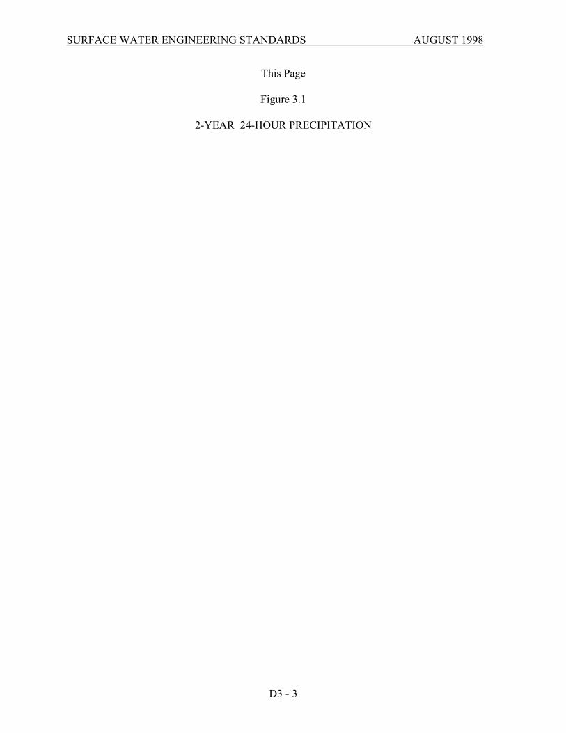
D3-02 DESIGN STORMS The design storm for all hydrograph analyses is a 24-hour duration, standard SCS Type I A rainfall distribution resolved to 10-minute time intervals (Table 3.1 herein). See Figures 3.1 through 3.3 herein for the Bellevue 24-hour precipitation isopluvials (developed from King County maps). When required by Chapter 24.06.130 (E), (G), or (J), of the Storm and Surface Water Utility Code, analysis of the following storms shall be provided. Existing and post-development conditions shall be analyzed to quantify runoff control and runoff treatment needs:
> 6-month, 24-hour storm (water quality design storm) > 2-year, 24-hour storm (streambank protection) > 10-year, 24-hour storm (runoff control) > 100-year, 24-hour storm (runoff control & conveyance)
DOE has determined that the 6-month, 24-hour precipitation is approximately equal to 64% of the 2-year, 24-hour precipitation.
D3 - 2
SURFACE WATER ENGINEERING STANDARDS AUGUST 1998
This Page
Figure 3.1
2-YEAR 24-HOUR PRECIPITATION
D3 - 3

SURFACE WATER ENGINEERING STANDARDS AUGUST 1998
This Page
Figure 3.2
10-YEAR 24-HOUR PRECIPITATION
D3 - 4

SURFACE WATER ENGINEERING STANDARDS AUGUST 1998
This Page
Figure 3.3 100-YEAR 24-HOUR PRECIPITATION
D3 - 5

SURFACE WATER ENGINEERING STANDARDS AUGUST 1998
D3-03 HYDROLOGIC MODELS Runoff control (detention) facilities shall be designed using hydrograph analysis. Use the procedures and methods outlined in Chapter III-1 of the DOE Manual. Conveyance systems may be designed using hydrograph-based computer modeling methods or the Rational Formula. Rational Method computation methods are described in Section D3-08. D3-04 TIME OF CONCENTRATION CALCULATIONS Use the procedures and methods outlined in Chapter III- 1 of the DOE Manual. Note: For smooth-wall plastic pipes, the "k" value used in time of concentration calculations shall be 5 0 (based on Manning coefficient "n" equal to 0. 0 10). D3-05 CURVE NUMBERS Use the procedures and methods outlined in Chapter III- I of the DOE Manual. Curve numbers for Western Washington are set forth in Table III -1.3 of the DOE Manual as modified herein. Older second growth (developed canopy) shall be modeled as "Wood or forestland: undisturbed" per Table III-1.3 of the DOE Manual. Replace the values for "Orchard: with cover crop" in Table III-1.3 of the DOE Manual with the following:
Cover Description Curve Numbers For Hydrologic Soil Group
Cover Type A B C D Woods/grass combination (orchard or tree farm).1
57 73 82 86
1CNs shown were computed for areas with 50% woods and 50% grass (pasture) cover. Use these values for Retained Vegetation Areas (RVAs). D3-06 SOIL TYPES Use site-specific geotechnical information for the project site (when available) or the Soil Survey -King County Area prepared by the Soil Conservation Service to identify the hydrologic soil group. Hydrologic groups for some King County soils have been revised (11/88). Table III-1.6 in the DOE Manual does not reflect those revisions. Use the revised values presented below:
Table III-1.6 Hydrologic Soil Groups for Soils in the Puget Sound Basin
D3 - 6

SURFACE WATER ENGINEERING STANDARDS AUGUST 1998
Soil Types Hydrologic Soil Group Soil Type Hydrologic Soil
Group
Arents, Alderwood Beusite Buckley Earlmont
C C D D
Indianola Klaus Norma
Woodinville
A C D D
D3-07 MINIMUM IMPERVIOUS AREAS For single family residential plat developments, use Table III-1.3 of the DOE Manual for minimum values. A higher percent impervious area shall be required if the proposed project plans indicate a greater impervious area coverage. Stormwater system designs shall take into account future build-out of the proposed development. For commercial and multi-family residential developments, use actual project values. Site areas set aside in NGPAs shall be excluded from the gross acreage value used in calculating dwelling units per "gross" acre. D3-08 RATIONAL METHOD D3-08.1 General
The Rational Method may be used with some specific limitations:
A. Only for use in predicting a conservative peak flow rate to determine the required capacity for conveyance facilities.
B. Drainage sub-basin area (A) shall not exceed 25 acres for a single
calculation. C. The time of concentration (Tc) must be computed using the method described below
and shall not exceed 100 minutes. It shall be made equal to 6.3 minutes when computed to be less than 6.3 minutes.
D3-08.2 Equation
The following is the traditional Rational Method equation: QR = C*IR*A
QR = peak flow (cfs) for a storm of peak rainfall intensity "IR" of a given return frequency (R)
D3 - 7

SURFACE WATER ENGINEERING STANDARDS AUGUST 1998
C = estimated runoff coefficient (ratio of rainfall that becomes runoff) IR = peak rainfall intensity (inches/hour) for a given return frequency (R) A = drainage sub-basin area (acres) D3-08.3 "C" Values The allowable runoff coefficients to be used in this method are shown in Table 3.2 by type of land cover. These values were selected following a review of the values previously acceptable for use in the Rational Method in Bellevue and as described in several engineering handbooks. The values for single family residential areas were computed as composite values (as illustrated below) based on the estimated percentage of coverage by roads, roof, yards and unimproved areas for each density. For drainage basins containing several land cover types, the following formula may be used to compute a composite runoff coefficient "CC". CC = ((C1 x A1) + (C2 x A2) + …+ (Cn x An)) /At where: At = total area (acres) A1,2,n = areas of land cover types C 1,2,n = runoff coefficients for each area land cover type
D3 - 8

SURFACE WATER ENGINEERING STANDARDS AUGUST 1998
TABLE 3.2 RUNOFF COEFFICIENTS - "C" VALUES FOR THE RATIONALMETHOD*
GENERAL LAND COVERS
LAND COVER
Dense forest Light forest Pasture Lawns
C
0.10 0.15 0.20 0.25
LAND COVER
Playgrounds (non-paved) Gravel areas Pavement and roofs Open water (pond, lakes, wetlands)
C
0.30 0.80 0.90 1.00
SINGLE FAMILY RESIDENTIAL AREAS (Density is in dwelling units per gross acreage (DU/GA))
LAND COVER
DENSITY
0.20 DU/GA (1 per 5 ac.) 0.40 DU/GA 0.80 DU/GA 1.00 DU/GA 1.50 DU/GA 2.00 DU/GA 2.50 DU/GA
C
0.17 0.20 0.27 0.30 0.33 0.36 0.39
LAND COVER DENSITY
3.00 DU/GA 3.50 DU/GA 4.00 DU/GA 4.50 DU/GA 5.00 DU/GA 5.50 DU/GA 6.00 DU/GA
C
0.42 0.45 0.48 0.51 0.54 0.57 0.60
For land covers not listed above, an area-weighted "C x At" sum should be computed based on the following equation: C x At, = (Cl x A1,)+ (C2x A2) +…+ (Cn. X An), where At, = (Aa, + As + …= An), the total drainage basin area. * (For use only in determining peak design flow for analyzing and sizing pipes, culverts or channels)
TABLE 3.3 COEFFICIENTS FOR THE RATIONAL METHOD"'iR" - EQUATION DESIGN STORM RETURN FREQUENCY (YEARS) aR bR
2 year 10 year 100 year
1.58 2.44 2.61
0.58 0.64 0.63
D3 - 9

SURFACE WATER ENGINEERING STANDARDS AUGUST 1998
D3-08.4 “IR" Peak Rainfall Intensity The peak rainfall intensity(IR )for the specified return frequency (R) design storm is determined using a unit peak rainfall intensity factor (iR) for a given return frequency (R) design storm using the following equation: IR = (Pr) (iR) where: Pr = is the total precipitation at the project site for the 24-hour duration
design storm event for the given return frequency (from the Isopluvial Maps in Figures 3.1 through 3.3.
iR = (aR)(TC) –(b
R); the unit peak rainfall intensity factor TC == time of concentration (minutes), calculated using the method described below only (Tc minimum value is 6.3 minutes). aR and bR are coefficients (from Table 3.3) used to adjust the equations for the design storm return frequency (R). This "'IR" equation was developed by King County SWM Division staff from equations originally developed by Ron Mayo, P.E. It is based on the original Renton/Seattle Intensity/Duration/Frequency (I.D.F.) curves. Rather than requiring a family of curves for various locations in King County this equation adjusts proportionally the Renton/Seattle I.D.F. curve data by using the 24-hour duration total precipitation isopluvial maps. This adjustment is based on the assumption that the localized geo-climatic conditions that control the total volume of precipitation at a specific location also control the peak intensities proportionally. Note: TC must not be less than 6.3 minutes or greater than 100 minutes. On the historic I.D.F. curves the lower limit was set at 5 minutes; 6.3 minutes was selected based on the mathematical limits of the equation coefficients. D3-08.5 "TC" Time of Concentration (Rational Method Only) The time of concentration is defined as the time it takes runoff to travel overland (from the onset of precipitation) from the most hydraulically distant location in the drainage basin to the point of discharge. Note that when the CC of a drainage basin exceeds 0.60, it may be important to compute the TC and peak rate of flow from the impervious area separately. The computed peak rate of flow for the impervious surface alone may exceed that for the entire drainage basin using the total drainage basin TC. The higher of the two peak flow rates shall then be used to size the conveyance facility. The TC is computed by summation of the travel times(s) (Tt) of overland flow across separate flow path segments defined by the six categories of land cover from the chart published in 1975 by the Soil Conservation Service shown in Table 3.4.
D3 - 10

SURFACE WATER ENGINEERING STANDARDS AUGUST 1998
The equation for time of concentration is: Tc = T1, + T2 +…+ Tn where: T 1,2,n = consecutive flow path segments of different land cover category or having significant difference in flow path slope
TABLE 3.4 KRVALUES FOR Tt USING THE RATIONAL METHOD LAND COVER CATEGORY
Forest with heavy ground litter and meadow Fallow or minimum tillage cultivation Short grass pasture and lawns Nearly bare ground Grassed waterway Paved area (sheet flow) and shallow gutter flow
kR
2.5
4.7
7.0
10.1
15.0
20.0
Travel time for each segment is computed using the following equation: Tt = L/60V (minutes) [Note, the T, through an open water body (such as a pond) shall be assumed to be zero with this method.] where: L= the distance of flow across a given segment (feet) V = avg velocity across the land cover (feet/second) Average velocity (V) is computed using the following equation: V = kR √SO where: kR = time of concentration velocity factoe (feet/second) (see Table 3.4) SO = slope of flow path (feet/feet)
D3 - 11

SURFACE WATER ENGINEERING STANDARDS AUGUST 1998
D3-09 PIPE SYSTEM ANALYSIS AND SIZING Figure 3.4 has been provided to allow for the tabular computation of "C-A" values used in sizing a new pipe system. Following computation of the time of concentration to the first structure, where flow enters the proposed pipe system, the travel times through the pipe lengths are added to become the Tc for the design flow at the next downstream pipe run. The flows computed at structures (manholes and catch basins) may be used to estimate the water surface profile along the pipe system. (Information regarding the Rational Method is taken from the Surface Water Design Manual, King County Surface Water Management Division.)
D3 - 12

SURFACE WATER ENGINEERING STANDARDS AUGUST 1998
This Page
Figure 3.4
RATIONAL METHOD FOR CONVEYANCE SYSTEM ANALYSIS AND SIZING
D3 - 13

SURFACE WATER ENGINEERING STANDARDS AUGUST 1998
CHAPTER D4 - HYDRAULIC ANALYSIS & DESIGN
TABLE OF CONTENTS D4-01 GENERAL .................................................................................................. D4-1 D4-02 DISCHARGE LOCATIONS....................................................................... D4-1 D4-03 OFF-SITE CAPACITY ANALYSIS .......................................................... D4-2 D4-04 CONVEYANCE SYSTEMS....................................................................... D4-4 D4-05 MANHOLES, CATCHBASINS AND INLETS....................................... D4-16 D4-06 RUNOFF CONTROL................................................................................ D4-18 D4-07 EASEMENT REQUIREMENTS.............................................................. D4-35
SURFACE WATER ENGINEERING STANDARDS AUGUST 1998
CHAPTER D4 - HYDRAULIC ANALYSIS & DESIGN D4-01 GENERAL Use the criteria set forth in Section 24.06.130 of the Storm and Surface Water Utility Code and the information provided herein to plan, design, and construct stormwater systems and facilities. Design the on-site stormwater system (conveyance, runoff control, runoff treatment, and emergency overflow elements) to accommodate runoff from the site and areas tributary to the site to prevent damage and injury. Conveyance systems shall be sized to safely convey the 100-year, 24 hour design storm runoff from areas tributary to the site to the discharge location. An emergency overflow for runoff control facilities shall be provided which prevents property damage or erosion caused by system failure. Roof and footing drains, yard drains, underdrains, ditches, swales, stormwater conveyance systems, etc. shall be installed to prevent damage or nuisance to adjacent properties and the public right-of-way due to the proposed development. Consider drainage system reliability in terms of layout, specification of materials and methods of installation, and the influence of other activities in the area both during and after construction. Minimize the frequency and difficulty of future maintenance by analyzing potential system failures and failure remedies. Access structures shall be accessible to City-owned maintenance equipment such as 5 CY dump trucks and vactor-type trucks. Visual impact and potential problems such as mosquito breeding, landscaping, odors, etc. shall be addressed. D4-02 DISCHARGE LOCATIONS D4-02.1 Impacts
Stormwater runoff from the project shall produce no significant adverse impact to downslope properties and shall discharge to the existing downstream drainage system.
D4-02.2 Unconcentrated Flow
Where no downstream drainage system exists adjacent to the property and the runoff from the project site was previously unconcentrated flow, the downstream drainage system shall be extended to the property line and all runoff from the property shall be conveyed across the downstream properties to an approved discharge location. The Developer shall secure drainage easements from the downstream owners and record such easements at the King County Office of Records and Elections prior to drainage plan approval.
D4 - 1

SURFACE WATER ENGINEERING STANDARDS AUGUST 1998
D4-02.3 Alternate Discharge If the Developer demonstrates that easements per Section D4-02.2 herein are not reasonably obtainable as determined by the City, then all runoff shall be conveyed to a dispersal and/or infiltration system per these engineering standards. D4-02.4 Temporary Discharges to the Sanitary Sewer Surface water runoff into the sanitary sewer system is prohibited by the Utility Code. Temporary discharges into the sanitary sewer system must meet with the approval of-
1.King County METRO 2.The Engineering Division of the Utilities Department; and 3.The Operations & Maintenance Division of the Utilities Department
The Bellevue Operations & Maintenance Division will determine the: • Location of connection to the sanitary sewer, • Method for the connection and pre-connection requirements, i.e. settling tanks, sump
pump, etc. • Time of discharge • Duration, rate and volume of the discharge • Other applicable discharge conditions The Developer is responsible for first obtaining a discharge permit from King County METRO prior to requesting permission from the City.
D4-03 OFF-SITE CAPACITY ANALYSIS Pursuant to Section 24.06.130(J) of the Storm and Surface Water Utility Code, an offsite capacity analysis is required whenever location of discharge will be changed by a proposed development. If the rate of discharge will be changed, and analysis may be required. Different levels of analysis of the drainage system are required, depending on both the location of the project in the basin and the information determined in the Level 1 analysis (described below). When required, a Level 1 analysis must be submitted with the Developer Extension Agreement.
D4 - 2

SURFACE WATER ENGINEERING STANDARDS AUGUST 1998
D4-03.1 Levels of Analysis
A. Level 1 Analysis
Physically inspect the existing on- and off-site drainage system and investigate any known problems. The analysis must extend from the proposed project discharge location to the point downstream where the site runoff would join the existing drainage course. On a map (minimum USGS 1:24000 Quadrangle Topographic Map) delineate the upstream tributary drainage areas to the site and to the downstream system. Describe in narrative form observations regarding the makeup and general condition of the drainage system. Include such information as pipe sizes, channel characteristics, and drainage structures. Specifically, the analysis must identify on the map, and describe in the narrative any evidence of the types of existing or anticipated problems. Following review of the Level 1 analysis, the City will determine whether the Level 2 analysis is required, based on the evidence of existing or anticipated problems.
B. Level 2 Analysis At each existing and/or predicted drainage problem location identified in the Level 1 analysis, develop hydrographs or Rational Method peak flow rates for the 100-year, 24-hour design storm events for the total composite drainage area tributary to that location for existing runoff conditions, excluding the proposed project site runoff. Determine the capacity of the existing drainage system. Non-survey field data (hand tapes, hand level and rods, etc.) and computations using Manning's equation for normal flow are acceptable for this analysis. At each existing and/or predicted drainage problem location, compute the proposed project's developed runoff hydrograph. Evaluate impacts of adding the controlled peak runoff from the proposed project site to the peak runoff from the total composite drainage area tributary to these locations. Additional information may be required to determine that impacts have been adequately mitigated and to verify the capacity of the conveyance system.
D4-03.2 Solutions to Identified Drainage Problems For any anticipated off-site problem resulting from the development or redevelopment, the Developer must demonstrate that the proposed project has been designed to mitigate the anticipated problem.
D4 - 3

SURFACE WATER ENGINEERING STANDARDS AUGUST 1998
As an alternative, the Developer, with approval by the City, may arrange with the owners of the off-site properties to install measures which will correct the existing or mitigate the anticipated problem. In some cases, existing public drainage system problems may already be scheduled for correction by the City. In these cases, the Developer should contact the Utilities Department to determine current capital improvement project schedules. Any proposed drainage easements must be executed by the affected property owners and be recorded prior to approval for construction.
D4-04 CONVEYANCE SYSTEMS
D4-04.1 General Use the criteria set forth in Section 24.06.130(C)(4) of the Storm and Surface Water Utility Code and the information provided herein to plan, design and construct stormwater conveyance systems. Off-site stormwater flows passing through the site shall be conveyed by a hydraulically adequate conveyance system as set forth herein. D4-04.2 Conveyance System Setbacks Conveyance systems shall not be located:
A. underneath any structure (e.g. buildings, sheds, decks, rockeries or retaining walls which run parallel to the pipeline, carports, etc.); and
B. within the 1: 1 plane from the bottom edge of the pipe or structure to the
finished grade at a building or structure; and C. within the 1: 1 plane from the bottom edge of the pipe or structure to the
property line at finished grade when an easement is not provided on the adjacent property; and
D. within one half of the minimum easement width of a structure; and
E. where such facilities interfere with other underground utilities; and F. where allowable design loads would be exceeded.
D4 - 4

SURFACE WATER ENGINEERING STANDARDS AUGUST 1998
D4-04.3 Clearances / Other Utilities A. All clearances listed below are from edge-to-edge of each pipe.
B. Check for crossing or parallel utilities. Maintain minimum vertical horizontal clearances. Avoid crossing at highly acute angles (the smallest angle measure between utilities should be between 45 and 90 degrees
C. Horizontal clearances from storm main:
Cable TV 5’ Gas 5’ Power 5’ Sewer 5’ Telephone, Fiber Optics 5’ Water 5’
D. Vertical clearances from storm main:
Cable TV 1’ Gas 1’ Power 1’ Sewer 1’ Telephone, Fiber Optics 1’ Water 1’
E. Where storm sewer pipes cross over or below a water main, one full
length of pipe shall be used with the pipes centered for maximum joint separation.
F. Send a letter and preliminary plan to existing utilities to inform them of
new construction. Request as-built information and incorporate into plans. At minimum the following utilities should be contacted: cable television, natural gas, power, sanitary sewer, telephone, water and telecommunications companies.
Avoid crossing other utilities at highly acute angles. The angle measure between utilities shall be between 45 and 90 degrees. For crossings of sanitary sewer pipes, the Washington Department of Ecology criteria will apply. Reinforced concrete and thermoplastic pipelines shall be encased in a steel or ductile iron casing when crossing under improvements (e.g. retaining walls) where the ability to
D4 - 5
SURFACE WATER ENGINEERING STANDARDS AUGUST 1998
remove and replace pipe without disturbance to the improvement is needed. Casing are required when:
• crossing under rockeries over five (5) feet high (measured from the bottom of the
base rock to top of wall);
• crossing under retaining wall footings over five (5) feet wide;
• crossing under segmental block, crib, and reinforced earth-type retaining walls.
Casings shall extend beyond the facing, footing and backfill reinforcement zone a minimum of five (5) feet or a distance equal to the depth of the pipe whichever is greater. The carrier pipe shall be supported by casing spacers when the casing length exceeds 10 feet where casing spacers are not used, the carrier pipe shall be more than 10 feet in length (no pipe joints inside casing). If the cover is less than 3 feet between the bottom of footing or base rock, a casing is required regardless of wall height. D4-04.4Open Channel Design Criteria
A. General Use the methods in Chapter III-2.3.6 of the DOE Manual except as modified herein. Swales shall be located no closer than 10 feet to any structure foundation measured horizontally from the edge of the swale at the freeboard elevation. B. Design Flow Rate Conveyance systems shall be sized to accommodate the peak runoff from a 100- year, 24-hour storm. C. Freeboard Requirements Minimum freeboard requirements for open channels shall be one half (0.5) foot below the top of bank for the design flow rate. D. Friction Factors Use factors set forth in Table III-2.8 of the DOE Manual. The design shall consider the channel roughness both immediately after construction and when vegetation is well established. E. Maintenance Access
D4 - 6

SURFACE WATER ENGINEERING STANDARDS AUGUST 1998
Provide maintenance access for inspection and debris removal by conventional equipment. The type of equipment needing access is dependent on the size of channel. Large channels will need access for dump trucks and loaders. For small ditches, foot or pick-up truck access may suffice.
D4-04.5 Flood Plain/Floodway Analysis
Use methods set forth in Chapter III.2.3.7 of the DOE Manual as modified by the Land Use Code Section 20.25H.110 and Section 24.06.090 of the Storm and Surface Water Utility Code.
D4-04.6 Culverts & Bridges A. Hydraulic Criteria - Bridges Bridges shall conform to Hydraulic Code Section WAC 220-110-070 and and Use Code Section 20.25(H) 110A. B. Freeboard Requirements - Bridges
The water surface elevation for the 100-year storm shall be a least one (1) foot below the lowest bridge girder to allow for the passage of floating debris.
C. Hydraulic Criteria - Culverts
Use methods set forth in Chapter III-2.3.4 of the DOE Manual as modified herein to design culverts. Determine capacity by analyzing inlet, outlet, and barrel controls. When an abrasive bed load is anticipated or when velocities exceed 10 feet per second, protective measures shall be implemented to minimize pipe damage. When a culvert is approved by the City in lieu of a bridge per Section 20.25(H)l10A of the Land Use Code, such culverts shall:
• span the bank full width of the channel; • be lined with bed material that is similar to the adjacent channel bed • have a slope similar to the existing channel; • have sufficient capacity and one (1) foot freeboard to pass the 100-
year design storm; and • meet the Washington State Hydraulic Code Rules.
D. Manning "n" values For culverts, use the factors set forth in Table III-2.2 of the DOE Manual.
D4 - 7

SURFACE WATER ENGINEERING STANDARDS AUGUST 1998
E. Design Flow Rate Conveyance systems shall be sized to accommodate the peak runoff from a 100-year, 24-hour storm. F. Freeboard Requirements - Culverts
For Type A and B streams, the water surface elevation for the 100-year storm shall be at least one (1) foot below the crown of the culvert to allow for the passage of floating debris.
G. Pipe Depths
For high density polyethylene pipe (AASHTO M 294 Type S), the maximum fill depth is 15 feet measured to the top of the pipe.
For PolyVinyl chloride pipe (profile and solid wall), the maximum fill depth is 20 feet.
For reinforced concrete pipe, the maximum fill depth is 15 feet for class III pipe and 25 feet for class V pipe.
For pipes greater than 25 feet, pipe type shall be determined on a case-by-case basis with back up calculations provided by the Developer.
Minimum cover is 2 feet from the top of pipe to the finished grade or as recommended in writing by the manufacturer, whichever is greater.
For installations where minimum cover requirements cannot be met, use Ductile Iron (DI), Class 52 pipe.
H. Minimum Diameter, Slope, and Velocity
Use the criteria set forth in Chapter III-2.3.4 of the DOE Manual as modified herein.
The minimum diameter of any driveway culvert shall be 12-inches. Where minimum cover requirements can be met, an 18-inch diameter culvert shall be used to minimize debris blockages.
Headwalls, cut-off walls, and/or anti-seep collars shall be provided on culverts where the hydraulic piping of bedding and backfill materials is possible.
I. Energy Dissipation
D4 - 8

SURFACE WATER ENGINEERING STANDARDS AUGUST 1998
When discharging to an existing ditch, swale, or stream, energy dissipation is required to avoid erosion. Design energy dissipation measures pursuant to Chapter III-2.3.5 of the DOE Manual.
J. Fish Passage
In fish bearing streams, the minimum diameter, slope, and velocity shall be governed by fish passage criteria in the Washington State Hydraulic Code.
K. Maintenance Access
Provide maintenance access to the upstream and downstream ends of the culvert for inspection and debris removal.
D4-04.7 Storm Drains
A. General
Storm drains shall be provided for curb street sections in accordance with the structure spacing requirements set forth in Section D4-05.2 herein. Where trench lines may convey groundwater, seepage barriers shall be installed. Catch basins or manholes are required when joining pipes of different materials (does not apply to "taps") and joining pipes of different slopes, vertical bends are not permitted.
If a vertical bend in a storm system is proposed by the Developer, is found to conform to Section S3-04 (N) of the sewer section of these Engineering Standards, and is approved by the City, then the system must be designed for video camera inspection and be video taped and pass inspection at the cost of the Developer before construction acceptance.
B. Hydraulic Criteria
Use the methods set forth in Chapter III-2.3 of the DOE Manual to design storm drains except as modified herein.
C. Design Flow Rate
Design conveyance systems in conjunction with runoff control to accommodate runoff from a 100-year, 24-hour storm.
D. Freeboard Requirements
D4 - 9

SURFACE WATER ENGINEERING STANDARDS AUGUST 1998
Design conveyance systems shall have non-pressurized (non-surcharged) flow during the 100- year design storm; except that the last pipe run upstream of a detention facility or open outfall (into a stream or lake) may be inundated during the 100-year event to a maximum distance of 200 linear feet, and if all the other conditions of the Engineering Standards are met. This also applies for those outfalls into streams where the outfall elevation is set at the bank-full water surface elevation (2-year storm) according to D4-04.9(A).
E. Manning "n" values
For pipe systems, use the factors set forth in Table III-2.2 of the DOE Manual. F. Pipe Depths
For corrugated polyethylene (CPE) pipe (AASHTO M 294 Type S), the maximum fill depth is 15 feet measured to the top of the pipe. For PolyVinyl chloride pipe (profile and solid wall), the maximum fill depth is 25 feet. For reinforced concrete pipe, the maximum fill depth is 15 feet for class III pipe and 25 feet for class V pipe. For pipes greater than 25 feet, pipe type shall be determined on a case-by-case basis with back up calculations provided by the Developer.
Minimum cover is 2 feet from the top of pipe to the finished grade or as recommended in writing by the manufacturer, whichever is greater. For installations where minimum cover requirements cannot be met, use Ductile Iron (DI), Class 52 pipe.
For corrugated polyethylene tubing (CPT), the maximum soil cover is one (1) foot.
G. Minimum Diameter, Slope and Velocity
Minimum slope for conveyance pipes shall be 0.5%. unless specified otherwise herein. Minimum diameter for a conveyance pipes in a roadway shall be 12-inches except for roadway laterals and pipes connecting private drainage systems to the municipal drainage system.
For roadway laterals, the minimum diameter is 8-inches provided:
• length of pipe does not exceed 100 feet;
D4 - 10
SURFACE WATER ENGINEERING STANDARDS AUGUST 1998
• pipe slope is greater than or equal to 2%;and • only one stormwater inlet contributes surface runoff to the roadway
lateral. For individual single family residences, conveyance pipes for roof, footing, and yard drains shall be a minimum of 4-inches in diameter. Connections to the municipal storm drain system shall be a minimum of 6-inches. For joint-use lines between single family homes, that portion of the line which is jointly used shall be 6-inches in diameter minimum. Minimum slopes for single family storm drain lines (footing and conveyance): 2% on 4-inch and 6-inch diameter, and 0.5% on 8-inch diameter (if used). The minimum velocity in all storm drain conveyance systems for the conveyance design storm (100-year, 24-hour) is 3 feet per second.
For driveways, parking lots and situations not listed above, the minimum diameter for conveyance pipes shall be 8-inches. Any storm line with a 20% slope or greater shall provide pipe anchors and hill holders according to the applicable storm drainage standard details.
H. Maintenance Access
All stormwater facilities shall be accessible for maintenance and operation.
When vehicle access is necessary, access roads shall be provided in dedicated tracts or dedicated access easements. The minimum clear driving lane width is 12 feet. Gates and/or bollards are required when necessary to restrict access to stormwater facilities. Such measures shall comply with the Land Use Code and these engineering standards. Cables and/or chains stretched across access roads are not acceptable.
D4-04.8Private Drainage Systems
D4-04.8(1)Private Single Family Drainage Systems
A. General
Private drainage systems shall comply with all criteria for stormwater systems set forth herein unless specifically exempted. In areas having an existing piped conveyance system, the stormwater outfalls for parking lot, driveway, and roadway drainage shall be made by the following (in order of preference):
D4 - 11

SURFACE WATER ENGINEERING STANDARDS AUGUST 1998
(1) Connecting the conveyance pipeline to an existing manhole or catch basin; or (2) Constructing a new manhole or catch basin on the existing storm drainage
pipeline and connecting the conveyance pipeline to this new structure.
In areas having an existing piped conveyance system, the stormwater outfalls for roof, footing, and yard drains may be made by the two methods mentioned above or by the following (in order of preference):
(1) Connecting the private drainage pipe to an existing storm drain manhole,
catch basin or stub-out if provided within 100 feet and downslope of the property line; or
(2) Coring the abutting conveyance pipeline and installing a saddle tee and
providing a clean-out outside of the public right-of-way; or (3) Coring the abutting profile wall conveyance pipeline (PVC or corrugated
polyethylene only; CMP may not be blind tapped) and installing an insert tee and clean-out outside of the right-of-way; or
(4) Installing a tee fitting in the abutting conveyance pipeline and providing a
clean-out outside of the public right-of-way; or (5)Connecting the private drainage pipe to an existing sidewalk drain; or (6) Providing a new sidewalk drain if the closest existing drainage system or
stub-out is greater than 100 feet and downslope of the property line. (7) Outfalling to an open channel or stream, provided that the drainage path
continues downstream to an established, known and well-functioning conveyance system, adequate erosion protection is provided and permits from other agencies are obtained, as needed.
When a project includes the construction of a drainage system, private drainage systems shall connect to the proposed storm drain manholes, catch basins, stub-outs, or tees. The use of sidewalk drains shall not be permitted. In areas without an existing drainage system, the private drainage system shall discharge in accordance with Section D4-02 (Discharge Locations) herein.
D4 - 12

SURFACE WATER ENGINEERING STANDARDS AUGUST 1998
B. Roof, Footing, and Yard Drains
Roof and footing drain pipes shall be separate lines which may only be joined as a non-perforated pipeline at an elevation at least one (1) foot below the lowest footing drain invert elevation. The minimum cover over the storm drain stub at the property line shall be two (2) feet.
Clean-outs (4-inch minimum diameter) with factory manufactured fittings, shall be provided at all junctions and bends greater than 45 degrees. The maximum spacing between clean-outs shall not exceed 100 feet. Roof, footing and yard drains shall not be connected to the sanitary sewer system. Roof, footing and yard drains shall not be located within the public right-of-way except where connecting to the municipal drainage system. Roof, footing and yard drain systems serving more than one parcel shall be within private utility easements. Roof, footing, and yard drainage may be conveyed over steep banks in single wall, corrugated polyethylene tubing (CPT) provided:
• the overbank drain is privately owned and maintained; • the minimum tubing slope is 15% or greater; • the CPT is continuous and without joints from the top of the slope
to the toe; • the CPT is a minimum of 4 inches and a maximum of 6 inches in
diameter; • a yard drain or clean-out is placed at the top of the slope; • the overbank drain is buried with a maximum cover of 1 foot.
CPT may not be used in the right-of-way, or for any other purpose except as a privately owned and maintained overbank drain.
C. Maintenance
Roof, footing, and yard drainage systems, drainage systems on commercial and multi-family properties, drainage facilities within private easements, and drainage facilities otherwise denoted as private, shall be designed to provide access for maintenance and operation by the owners of such facilities.
D4 - 13

SURFACE WATER ENGINEERING STANDARDS AUGUST 1998
D4-04.8(2) Private Commercial and Multi-Family Drainage Systems
A. General
In areas having an existing piped conveyance system, the stormwater outfalls for parking lot, driveway, and roadway drainage shall be made by the following (in order of preference): (1) Connecting the conveyance pipeline to an existing manhole or catch basin; or (2) Constructing a new manhole or catch basin on the existing storm drainage pipeline and connecting the conveyance pipeline to this new structure. In areas having an existing piped conveyance system, the stormwater outfalls for roof, footing, and yard drains may be made by the two methods above or by the following (in order of preference): (1) Connecting the private drainage pipe to an existing storm drain manhole,
catch basin or stub-out if provided within 100 feet and downslope of the property line; or
(2) Coring the abutting conveyance pipeline and installing a saddle tee and
providing a clean-out outside of the public right-of-way; or (3) Coring the abutting profile wall conveyance pipeline (PVC or corrugated
polyethylene only; CMP may not be blind tapped) and installing an insert tee and clean-out outside of the public right-of-way; or
(4) Installing a tee fitting in the abutting conveyance pipeline and providing a
clean-out outside of the public right-of-way; or (5) Connecting the private drainage pipe to an existing sidewalk drain; or (6) Providing a new sidewalk drain if the closest existing drainage system or
stub-out is greater than 100 feet and downslope of the property line; or (7) Outfalling to an open channel or stream, provided that the drainage path
continues downstream to an established, known and well-functioning conveyance system, adequate erosion protection is provided and permits from other agencies are obtained, as needed.
When a project includes the construction of a drainage system, private drainage systems shall connect to the proposed storm drain manholes, catch basins, stub-outs, or tees. The use of sidewalk drains shall not be permitted.
D4 - 14

SURFACE WATER ENGINEERING STANDARDS AUGUST 1998
In areas without an existing drainage system, the private drainage system shall discharge in accordance with Section D4-02 (Discharge Locations) herein.
B. Runoff Control and Runoff Treatment Facilities Runoff Control and Runoff Treatment Facilities shall comply with all criteria for stormwater systems set forth herein unless specifically exempted.
C. Other Onsite Drainage Facilities Drainage facilities for commercial and multi-family properties shall comply with all criteria for stromwater systems set forth herein; however, they are exempt from sections D4-04, D4-05, D7-02, D7-03, D8-04, D8-05, and Appendix D-1 Standard Details, except for any portions within these sections that relate to Runoff Control and/or Runoff Treatment Facilities. Other on-site private drainage facilities shall be designed by a professional engineer licensed by the State of Washington to meet City Storm & Surface Water Utility Codes using industry standards and practices.
D. Maintenance Drainage systems on commercial and multi-family properties, drainage facilities within private easements, and drainage facilities otherwise denoted as private, shall be designed to provide access for maintenance and operation by the owners of such facilities.
D4-04.9 Outfalls
A. General
Use methods set forth in Chapter III-2.3.5 of the DOE Manual as modified herein. Storm drain pipelines shall not be installed above ground. Outfalls shall discharge at the bank-full water surface elevation (2-yr storm) in open channels or streams. Conveyance systems downstream of detention facilities or water quality treatment facilities shall be designed to prevent backwater conditions in those facilities. The use of pumped systems or backflow preventers shall not be used to prevent flooding due to backwater conditions.
D4 - 15

SURFACE WATER ENGINEERING STANDARDS AUGUST 1998
B. Energy Dissipation
When discharging to an existing ditch, swale, or stream, energy dissipation is required to minimize erosion. Design energy dissipation measures pursuant to Chapter III-2.3.5 of the DOE Manual as modified herein. For exit velocities in excess of 10 fps, provide an engineered energy dissipator. Riprap and gabions are not sufficient.
C. Maintenance Access
Provide maintenance access for inspection and debris removal.
D4-05 MANHOLES, CATCHBASINS AND INLETS D4-05.1 General
Stormwater inlets in a roadway shall be located in the curb line and shall be fitted with bolt locking vaned grates. For any roadway drainage structure located out of the curb line and in a travel lane, a 24-inch, bolt locking ring and cover shall be installed. A through-curb inlet frame shall be used where conditions limit the effectiveness of a flat grate inlet. Examples of such conditions are where a high likelihood of clogging from leaf fall or other debris exists, in sag vertical curves, intersection curb returns, and when the structure is a surface drainage end point, such as in a cul-de-sac.
Bi-directional vaned grates shall be used in sag vertical curves. When a catch basin, manhole, or concrete inlet is located off the traveled portion of the roadway or under other conditions of limited surveillance, the grate or cover shall be bolt locking. Vertical ladders or steps shall be installed immediately under the cover or grate opening to a walkable surface on all structures exceeding four feet deep to the pipe invert.
D4 - 16

SURFACE WATER ENGINEERING STANDARDS AUGUST 1998
D4-05.2 Spacing Requirements
TABLE 4.1 PIPE SIZES AND LENGTHS BETWEEN STRUCTURES Upstream Structure to Downstream Structure
Pipe Diameter (Inches)
Minimum Pipe Slope (%)
Maximum Structure Spacing (ft)
Inlet/MH to Inlet/MH Inlet/MH to CB Inlet/MH to CB CB to CB CB to CB/MH MH to MH
128
128
12 or greater12 or greater
2.0% 2.0% 1.0% 1.0% 0.5% 0.5%
150-300 (i, iii100150
150-300 (ii, iii)150-300 (iii)
400 (iv) (i) Compensatory catchment must be provided in downstream, on-site catch basin(s). (ii) Driveways, parking lots, and private systems only. (iii) Maximum spacing between grates shall be:
• 150 feet on surface grades less than 1%; and • 200 feet on surface grades from 1% to 3%; and • 300 feet on surface grades over 3%; or • as required by grate flow capacities.
(iv) Access points only - no stormwater inputs. (v) A type 2 catch basin is required to be installed for every 800 linear feet of storm
drain pipeline.
TABLE 4.2 ALLOWABLE STRUCTURES AND PIPE SIZES Maximum Pipe Diameter
Structure Type (i) SOLID WALL PIPE HDPP, PVC, DI, CMP (v)
PROFILE WALL PIPE RCP, CPE
Concrete Inlet (ii iii) Type I CB (ii) Type I L CB (iv) Type 2 - 48 inch diam. Type 2 - 54 inch diam. Type 2 - 60 inch diam. Type 2 - 72 inch diam. Type 2 - 84 inch diam. Type 2 - 96 inch diam.
12” 15” 24” 30” 36" 48” 54” 60” 72”
12” 12” 18” 24” 30” 36” 42” 54” 72”
(i) Catch basins, manholes, and inlets including steps, ladders, and handholds shall
conform to WSDOT Standard Plans.
(ii) Maximum four (4) vertical feet allowed between grate/cover and pipe invert elevation.
D4 - 17

SURFACE WATER ENGINEERING STANDARDS AUGUST 1998
(iii) Limited to one inletting pipe, 6 inches or less in diameter. (iv) Maximum five (5) vertical feet allowed between grate/cover and pipe invert elevation. (v) CMP allowed for detention pipe only. The number and size of pipes that may be connected to any one structure is limited in order to maintain the integrity of the structure. For angled connections or those with several pipes on the same plane, a larger structure than set forth in the Table 4.2 above may be required. For structural integrity, minimum undisturbed wall (edge of pipe opening to edge of pipe opening) shall be 8-inches. For 72-inch and 96-inch diameter structures, the minimum undisturbed wall between openings is 12 inches. Detailed plans of structures with multiple pipes or angled connections may be required to ensure proper structure selection. D4-05.3 Maintenance Access Where no direct maintenance vehicle access from a maintenance access road can be provided or when greater than 15 feet from a roadway, all structures shall be channelized and shall not have catchment. Provide an oversized catch basin to compensate for lost catchment at the first available access point for maintenance vehicles. The maximum manhole spacing on conveyance pipelines which do not have any stormwater inlets shall be 400 feet. D4-06 RUNOFFCONTROL D4-06.1 General
Use the criteria set forth in Section 24.06.130 of the Storm and Surface Water Utility Code and design guidelines Chapter III-4 of the DOE Manual as modified herein to plan, design and construct stormwater detention systems. Runoff control is not required if the total area where runoff rates will change (increase or decrease) is less than 5,000 square feet. The volume correction factor set forth in Figure III- 1. 1 of the DOE Manual shall be applied to all detention system designs. Site totals for impervious and pervious areas shall be consistent with totals stated on the plans and used for detention sizing calculations (Section D3-07 herein). When existing conditions make stormwater detention impossible for a portion of a site, compensatory storage volume and reduction of the release rates may be allowed if the bypass area and detention system are tributary to one drainage basin both prior to and after development. The peak rate of runoff (developed condition) from the bypass areas shall be subtracted from the allowable release
D4 - 18

SURFACE WATER ENGINEERING STANDARDS AUGUST 1998
rate to determine the detention system release rate. In no case shall the runoff from the entire site exceed the allowable release rate.
Runoff control systems shall be designed to maximize reliability, minimize maintenance needs, maximize the distance between the inlet and outlet in order to improve runoff quality, and minimize hazards to persons or property (both on-site and off-site), nuisance problems and risk of failure. In areas of high groundwater, the groundwater collection system flows shall bypass the detention system. Runoff control facilities that serve multiple sites are subject to all of the engineering and design requirements contained in the Storm and Surface Water Utility Code and these Standards. Conceptual site plans for all sites to be served by the proposed stormwater facilities shall be submitted to the City for review. Construction of the facilities must occur in conjunction with the first project to be served by the runoff control facilities. Detention is waived for site areas which are or will be set aside in Native Growth Protection Areas (NGPAs) provided such NGPAs are in separate tracts, or in easements which are permanently fenced or permanently signed when included as part of the lot or the developed parcel. Detention system design shall assume that all other pervious areas will be landscaped as part of or following development.
The 100-year water surface elevation shall be at least 100 foot below the lowest habitable finished floor elevation in the area that is tributary to the stormwater detention facility.
The 100-year water surface shall not surcharge roof, footing and yard drains, or underdrains. Street and parking overlays are considered to be routine maintenance and are not considered to be redevelopment per Section 24.06.050(U) of the Storm and Surface Water Utility Code. Removal of pavement to subgrade and subsequent replacement (not including spot base repairs) is considered to be complete reconstruction which qualifies as redevelopment and disturbance. Such reconstruction is not considered to be routine maintenance. Runoff control facilities for the right-of-way shall be owned and operated by the City and shall be separate from private on-site systems. If the area in the right-of-way where runoff rates will change (increase or decrease) is less than 5,000 square feet, runoff control is not required. In a plat where the stormwater facilities will be owned and operated by the City, runoff from the right-of-way and private properties in the plat may be combined and controlled in a single facility. Private
D4 - 19
SURFACE WATER ENGINEERING STANDARDS AUGUST 1998
detention systems may accommodate public drainage (e.g., from a public right-of-way) if a hold harmless agreement is completed by the developer and recorded against the property, and the proposal meets all the other design requirements of the Utility. Drainage basins may be considered as separate if tributary areas drain to different streams, or if areas drain to Lake Sammamish or Lake Washington via separate drainage routes that do not join at any point prior to the lake.
D4-06.2 Design Flow Rates A. General
Design flow rates are established in Section 24.06.130(E) of the Storm and Surface Water Utility Code. Upstream off-site runoff must bypass the proposed detention facilities unless the existing peak runoff rate from the upstream off-site area for the 100-year, 24-hour design storm event is less than 50 percent of the allowable release rate for the 100-year, 24-hour design storm event of the proposed project.
B. Sites with Existing Stormwater Detention Systems
When runoff control is required on a site with an existing detention system, the Developer may choose one of the following options:
1. Retain the existing detention system to control runoff from existing
impervious surfaces and design a second system per the current codes to control runoff from new portions of the development; or
2. Retain the existing detention system, modify the control structure and add volume as needed to meet the current codes for runoff control; or
3. Replace the existing detention with a system designed to meet the
current codes for runoff control.
When choosing option 1, the Developer must demonstrate that both systems will operate as intended. This option generally requires most of the existing detained development to be hydraulically separated from the proposed development. When choosing option 2 or 3, the Developer must first determine whether the existing system was designed to restrict flows using a single release rate or using two release rates (multiple orifices). Prior to 1995, single release rate systems were generally required on sites of 5-acres or less, which were more than 1/4 mile from a Type A or B stream. Two release rate systems were generally required
D4 - 20

SURFACE WATER ENGINEERING STANDARDS AUGUST 1998
under previous standards on greater than 5 acre sites and on sites within 1/4 mile of a Type A or B stream.
When modifying or replacing an existing single release rate detention system, the "existing peak runoff rate" referred to in Section 24.06.130(E), shall be equal to the discharge from the existing detention system. These systems were generally designed to discharge at a peak rate of 0.2 cubic feet per second per acre of property, when the system was full. A simplified equation was used to calculate the volume required to store the 100-year design storm.
To accurately determine the "existing peak runoff rate" for the 2 and 10-year design storms, the Developer may choose to model the existing detention system. To simplify the calculations, the Developer may choose to design the new system based on an existing runoff rate of 0.2 cubic feet per second per acre for all design storm events.
The discharge from the detention system depends on the depth of water stored in the system during the design storm events and the orifice size. However, the discharge from the system is more dependent on the size of the control orifice than the depth of water stored above the outlet. The incremental increase in storage depth is smaller for larger storms events. The difference in outflow from the existing system during the 2-year and 100-year design storms would not be expected to be significant enough to warrant modeling the existing system.
When modifying or replacing an existing two release rate detention system, the "existing peak runoff rate" referred to in Section 24.06.130(E), should be calculated using standard hydrograph methods, using the assumption that the site is undisturbed and forested. (Two release rate systems were generally designed to release the 10-year developed site storm runoff at a 2-year forested site rate and the 100-year developed site runoff at a I 0-year forested site rate. New detention systems for these sites will not have to reduce runoff to less than the pre-developed (forested) rates for the 10 and 100-year design storms.)
D4-06.3 Multi-Purpose Use
Detention facilities designed for multiple use (sport courts, neighborhood parks, play areas, picnic areas, etc.) are allowed. Storage for runoff from more frequent storms shall be stored separately from the multiple use areas. At a minimum, the detained volume for the 2-year, 24-hour design storm shall be used to size the separate facilities. Multi-use amenities shall be anchored to prevent floatation. Maintenance of multi-use amenities will be by others and Developer shall make arrangement for such maintenance.
D4 - 21
SURFACE WATER ENGINEERING STANDARDS AUGUST 1998
D4-06.4 Control Structures A. General
Use the criteria and methods set forth in Chapter III-2.4 of the DOE Manual except as modified herein. Allowable release rates shall be achieved using a tee type flow restrictor to meter flows. All restrictor devices to be maintained by the City shall be equipped with a shear gate. Restrictor devices on privately maintained detention facilities may use a gasketed end cap.
B. Clearances
The minimum clearance between the rim of the overflow standpipe and the bottom side of the structure's top slab shall be no less than 0.5 feet. The minimum clearance between the flow restrictor (standpipe, orifices, shear gate, etc) and the steps/ladder rungs shall be two (2) feet.
C. Orifices
Minimum orifice is one (1) inch in diameter without screening. When screening is provided to prevent blockage, the orifice size may be reduced to a minimum of 0.5-inch.
DOE Manual Error: Figure III-2.35 V-Notch, Sharp Crested Weir - In Section A-A, "H" and "Y" are reversed. "Y" is equal to depth below the notch. "H" is the height of the water column passing through the weir notch. DOE Manual Error: Chart on page III-2-64 - The vertical axis of the chart should be Cd, not C1. The horizontal axis should be "H/Y", not ‘Fraction of H’. A notch weir may be incorporated into the tee-type flow restrictor when a floatables baffle is provided. See Figure III-2.33 of the DOE Manual.
D. Maintenance Access
Covers, grates, and hatches shall be bolt locked.
D4 - 22

SURFACE WATER ENGINEERING STANDARDS AUGUST 1998
All stormwater detention system control structures shall be accessible for maintenance and operation.
In single family residential subdivisions, control structures which are not abutting a roadway shall be providedwith dedicated tracts at least 15 feet wide to accommodate maintenance vehicles. The minimum clear driving width shall be 12 feet. In multi-family and commercial developments, control structures which are not abutting a roadway shall be provided with access to accommodate maintenance vehicles. The minimum clear driving width shall be 12 feet. Maximum access road grades:15% (paved) 10% (gravel) Minimum turn-around radius: 25 feet or hammerhead. Gates and/or removable bollards are required to restrict access, as necessary, to drainage facilities. Such measures shall comply with the Land Use Code and these engineering standards. Cables and chains stretched across access roads are not acceptable.
D4-06.5 Ponds A. General
Use the criteria and methods set forth in Chapter III-4 of the DOE Manual as modified herein. Stormwater detention ponds may be used as interim sedimentation facilities if cleaned and restored to approved plan conditions following completion of all on-site construction. Stormwater shall be routed through a catch basin prior to discharging to the pond in order to facilitate the easy removal of transported sediments and debris.
B. Design Criteria
Provide debris barriers or trash racks on the detention pond outlet to protect the outlet from blockage or plugging.
C. Embankments
All embankments for detention and treatment facilities shall comply with Dam Safety Guidelines as published by the Dam Safety Division of the Department of
D4 - 23

SURFACE WATER ENGINEERING STANDARDS AUGUST 1998
Ecology, current edition. The maximum embankment height is measured from the downslope toe to the crest of the embankment. All embankments for detention facilities six (6) feet and higher shall be designed, inspected and certified by a civil/geotechnical engineer. The civil/geotechnical engineer shall submit a letter certifying that all embankment design requirements have been met during embankment construction. Anti-seep collars shall be placed on all conveyance pipes and trenches within the embankment. The maximum height of rockeries subject to inundation due to fluctuating pond levels is four (4) feet. The exposed face of the rockery shall be above the permanent pool elevation. Rockery drains shall drain through the detention system.
Ponds may be designed with retaining walls only as approved by the City on a case-by-case basis and provided that the design conforms to DOE Section III4.6. 1. Public safety shall be a primary design consideration.
D. Dimensions Detention Pond Setbacks Detention ponds shall not be located:
• within the 1: 1 plane from the pond bottom to the finished grade at an adjacent building; and
• within the 1: 1 plane from the pond bottom to the property line when
an easement is not provided on the adjacent property; and
• where such facilities interfere with other underground utilities.
The top of a cut embankment and the toe of a fill embankment shall be setback at least five (5) feet from property lines. For ponds where the maximum design water depth is less than three (3) feet deep, the minimum bottom width is six (6) feet. For ponds where the maximum design water depth is three (3) feet deep and greater, the minimum bottom width shall be three (3) times the maximum design water depth. The pond bottom shall be sloped at 0.5% towards the outlet for drainage to help facilitate maintenance.
D4 - 24

SURFACE WATER ENGINEERING STANDARDS AUGUST 1998
E. Maintenance Access
Use the criteria set forth in Chapter III-4.4 of the DOE Manual as modified herein. A vehicle access ramp shall be provided to the bottom of the detention pond when the bottom width is 15 feet or greater and/or when the height of the interior pond embankment and/or wall is greater than four (4) feet. The grade of the access ramp shall be no steeper than 20%. Gates and/or removable bollards may be required to restrict access to drainage facilities. Such measures shall comply with the Land Use Code and these engineering standards. Cables and chains stretched across access roads are not acceptable.
F. Safety
Use the criteria set forth in Chapter III-4.4 of the DOE Manual. Fencing shall be required when vertical walls are used, when more than 25% of the perimeter side slopes are steeper than 3 H: IV, and when the permanent ("dead") pool depth exceeds three (3) feet.
G. Emergency Overflow & Spillways
Use the criteria set forth in Chapter III-4.4 of the DOE Manual as modified herein. All detention storage facilities shall include a provision for non-erosive control of overflows. Overflows shall be directed to a safe discharge path to protect adjacent and downstream properties from damage. Provide calculations and data to support the design. Surface detention ponds shall be provided with a minimum of two controlled emergency overflows - the primary overflow in the control structure and the secondary overflow in the engineered embankment. The crest of the secondary overflow shall be at least 0.5 feet above the crest of the primary overflow.
D4 - 25

SURFACE WATER ENGINEERING STANDARDS AUGUST 1998
H. Vegetation & Landscaping
Detention pond landscaping shall comply the requirements of Type III landscaping set forth in Section 20.20.520 of the Land Use Code and as specified herein. Ponds with walls higher than six (6) feet shall be landscaped to Type II requirements set forth in Land Use Code Section 20.20.520 and as specified herein. Deciduous trees shall not be utilitized in and around detention ponds. However, deciduous shrubs and shrub/trees (e.g. Vine Maple) may be used in the understory to provide needed diversity for a pleasing appearance. All ponds shall be landscaped to provide for slope stability, erosion control, and low maintenance. Landscape materials shall be fully compatible with use as a stormwater detention facility including runoff treatment. Floatable or erodible material (i.e. wood chips, beauty bark, straw mulch, etc.) shall not be allowed in the pond interiors.
Vegetation on pond embankments shall be limited to shallow rooted varieties. Vegetation shall be placed into topsoil above or adjacent to the engineered embankment.
Where detention pond landscaping shall be maintained by the Utilities Department, landscaping shall be non-irrigated, low maintenance, and drought tolerant and shall consist of native plant species. Lawn or turf grass is not allowed.
Use the criteria set forth in Chapters 11-5.4.3 and III-4.4 of the DOE Manual to assist in appropriate vegetation selection.
D4-06.6 Underground Detention Systems A. General
Use the criteria and methods set forth in Chapter III-4 of the DOE Manual as modified herein.
All stormwater shall be routed through a catch basin prior to discharging to detention vaults or pipes to facilitate the easy removal of transported sediments and debris.
B. Design Criteria Detention Vault/Tank Setbacks Detention vaults/tanks shall not be located:
D4 - 26

SURFACE WATER ENGINEERING STANDARDS AUGUST 1998
• underneath any structure (e.g. buildings, sheds, decks, carports, retaining
walls, etc.); and • within the 1: 1 plane from the bottom edge of the vault or the bottom of the
excavation at the outside diameter for tanks, to the finished grade at an adjacent structure foundation; and
• within the 1: 1 plane from the bottom edge of the vault or the bottom of the excavation at the outside diameter for tanks, to the property line when an easement is not provided on the adjacent property; and
• where such facilities interfere with other underground utilities.
If vaults are constructed above ground, they shall be provided with visual screening and landscaping. When the design of vaults does not take into account buoyancy or hydrostatic pressure, footing drains shall be provided. Footing drains shall be backfilled to within two (2) feet of the top of the vault with Gravel Backfill for Drains conforming to Section 9-03.12 (4) of the Standard Specifications. The gravel backfill shall be protected from contamination by soil fines.
When the design of tanks or pipes does not take into account buoyancy, underdrains shall be provided. Underdrains within the pipe trench shall be backfilled from the bottom of the pipe to the crown with Gravel Backfill for Drains conforming to Section 9-03.12 (4) of the Standard Specifications. The gravel backfill shall be protected from contamination by soil fines. Clean-outs on footing drains and underdrains shall be provided every 100 feet and at bends or drain pipe junctions. Connection to the stormwater conveyance system shall be at a point where the hydraulic grade line in the conveyance pipe does not affect the free draining ability of the footing drains or underdrains.
C. Minimum Size
The minimum diameter of a detention pipe shall be 36-inches. The minimum height of any detention vault shall be 42-inches.
D. Pipe Depths
For high density polyethylene pipe (AASHTO M 294 Type S), the maximum fill depth is 15 feet measured to the top of the pipe. For PolyVinyl chloride pipe (profile and solid wall), the maximum fill depth is 20 feet.
D4 - 27
SURFACE WATER ENGINEERING STANDARDS AUGUST 1998
For reinforced concrete pipe, the maximum fill depth is 15 feet for class III pipe and 25 feet for class V pipe. For pipes buried greater than 25 feet deep, pipe type shall be determined on a case-by-case basis with back up calculations provided by the Developer.
Minimum cover is 2 feet from the top of pipe to the finished grade or as recommended in writing by the manufacturer, whichever is greater. For installations where minimum cover requirements cannot be met, use Ductile Iron (DI), Class 52 pipe, or AWWA C900 PVC pipe.
E. Structural Design
Use the criteria set forth in Chapter III-4.5 of the DOE Manual and by the City Building Official. Note that where the top of a vault is in a traveled way, additional loading requirements to accommodate fire trucks will apply. Please consult the Building Division of the Department of Planning and Community Development for available information on Structural Slab Design Loadings in the Permit Center.
Hydrostatic Pressure & Buoyancy Use the criteria set forth in Chapter III-4.5 of the DOE Manual as modified herein. If permanently lowering the groundwater in the vicinity is not feasible, then pipes and vaults shall be designed to accommodate hydrostatic loading and buoyancy effects.
F. Maintenance Access
Use the criteria set forth in Chapter III-4.5 of the DOE Manual as modified herein. Since underground detention facilities are subject to confined space entry regulations, such facilities shall be designed to facilitate safe inspection and maintenance. Access structures at each end of the facility shall be required. Spacing between access openings shall not exceed 50'. Covers, grates, and hatches shall be bolt locking. If the vault or pipe contains cells, one access minimum per cell is required. Access openings shall be 24" in diameter per Standard Detail D-22 and centered over a ladder and/or steps. For control structures, accesses must be located so that an 8" rigid vactor tube can reach the sump directly from the top, and so that a person entering the structure can step off the ladder or steps onto the floor.
D4 - 28
SURFACE WATER ENGINEERING STANDARDS AUGUST 1998
The opening shall allow visual inspection of the restrictor pipe, while maintaining vertical vactor access to the sump area.
In order to achieve both requirements, it may be necessary to increase the control structure size, provide two 24" access openings or a hatched cover that conforms to the loading requirements given the proposed location. Orifice elbows shall be located on the side of the stand pipe nearest the ladder for clear visual inspection from above. Gates and/or removable bollards may be required to restrict access to drainage facilities. Such measures shall comply with the Land Use Code and these engineering standards. Cables and/or chains stretched across access roads are not acceptable.
D4-06.7 Infiltration Systems A. General Infiltration Systems for Runoff Control
Infiltration systems shall be approved if they meet the requirements of Section 24.06.130(E)(2) or (3) of the Storm and Surface Water Utility Code. A detention system may be required in conjunction with the infiltration system to meter flows to an infiltratable rate. Infiltration areas shall not be: 1) driven on or across by any vehicles or equipment, 2) used for material storage or stockpiles, or 3) used for vehicle or equipment parking. Infiltration areas shall be secured with temporary fencing prior to clearing the site. Approval of an infiltration system shall obligate the owner to repair, replace, or reconstruct the infiltration system if it fails to operate as designed. The maintenance and operation schedule for an infiltration system shall include such a provision.
Roof Downspout Infiltration Systems Roof downspout infiltration systems shall be approved if they meet the requirements of Section 24.06.130 (E) (2) or (3) of the Storm and Surface Water Utility Code.
D4 - 29

SURFACE WATER ENGINEERING STANDARDS AUGUST 1998
Areas proposed for infiltration shall be secured with temporary fencing prior to clearing the site. Existing, developed lots shall locate downspout infiltration systems in areas which have not previously been: 1) driven on or across by vehicles or equipment, 2) used for material storage or stockpiles, or 3) used for vehicle or equipment parking. Approval of a downspout infiltration system shall obligate the owner to repair, replace, or reconstruct the infiltration system if it fails to operate as intended. All the general requirements of D4-06.7 (A) shall apply, except that infiltration trenches may be located under new pavement according to the criteria in the KCSDWM.
B. Design Criteria Infiltration Systems for Runoff Control
Use the criteria set forth in Chapter III-3 of the DOE Manual as modified herein. The Developer shall demonstrate through: 1) Infiltration testing; 2) Soil logs; and 3) A written opinion of a licensed civil/geotechnical engineer, that sufficient permeable soils exists on the site for an infiltration system meeting the requirements herein and site-specific conditions to function properly. Depth to seasonal high water table, bedrock, hardpan or other impermeable layer shall be no less than three (3) feet below the bottom of roof downspout infiltration systems and five (5) feet below the bottom of all other infiltration facilities. The infiltration rate shall be measured at a depth equal to the proposed bottom grade of the facility. The maximum infiltration rates for the various soil types is set forth in Table 4.3 herein. The maximum rate used to calculate the design infiltration rate shall be the lesser of the values set forth in Table 4.3 and the measured rate.
TABLE 4.3 MAXIMUM INFILTRATION RATES FOR SOIL TYPES Soil Texture Class (U.S.D.A.)
Infiltration Rates (Inches per Hour)
1. Coarse sands, cobbles 20 2. Medium sand 8.0 3. Fine sand, loamy sand 2.4 4. Sandy loam 1.0 5. Loam 0.50
D4 - 30

SURFACE WATER ENGINEERING STANDARDS AUGUST 1998
To obtain the design infiltration rate, the following safety factors shall be applied depending on the test method selected. The safety factor shall be applied to the lesser infiltration rate, either the measured rate, or the tabulated rate in Table 4.3. EPA Method: F.S. = 2.0 ASTM Method: F.S. = 1.75
Infiltration facilities shall not be located : 1) within 20 feet of any structure, property line, Native Growth Protection Area or Protected Area (as defined by the Land Use Code) or another infiltration system; or 2) within the 1: 1 plane from the bottom edge of the excavation to the finished grade at the structure foundation, whichever is greater, except as provided herein. A roof downspout infiltration system shall not be located: 1) within ten (10) feet of a structure; or 2) within the 1: 1 plane from the bottom edge to the excavation to the finished grade at the structure foundation, whichever is greater. Infiltration facilities shall be setback at least 50 feet from downhill slopes which are 15% or greater. The DOE Manual requirement that infiltration systems be located at least 100 feet upslope from structure foundations may be modified if the Developer demonstrates that the potential impacts to downslope structures and improvements from upslope infiltration facilities is minimal. Infiltration systems for runoff control shall be designed to infiltrate the 100-year, 24-hour design storm volume in 24 hours or less after the storm is over. Soils that are capable of meeting this criteria are generally limited to Hydrologic Soil Group - Type A soils per the Soil Survey - King County Area by the Soil Conservation Service. Soil capabilities must be confirmed by geotechnical investigation.
Roof Downspout Infiltration Systems Roof downspout infiltration system shall be limited to projects where the roof area for each structure does not exceed 5,000 square feet. When the roof area of a structure exceeds 5,000 square feet, other infiltration methods shall be used. Use the criteria set forth in the King County Surface Water Design Manual as modified herein: Construction of the infiltration trench shall conform to Standard Detail D-41 of the engineering standards. All the design criteria of D4-06.7 (B) shall apply except that the factor of safety and maximum infiltration need not apply (given the current sizing methods). Also, the Developer need not provide infiltration testing for the proposed sizing.
D4 - 31

SURFACE WATER ENGINEERING STANDARDS AUGUST 1998
A short report must be prepared according to the requirements of the KCSV*IDM and this section. Sections D4-06.7 (C) (D) (E) (F) (G) and (H) shall not apply to roof downspout infiltration systems.
C. General Data Requirements
Provide a written report which includes as a minimum: 1) Site characteristics that pertain to the proposed infiltration system; 2) Soils report with soil logs; 3) Written civil engineer's opinion of site suitability and recommended design infiltration rate; 4) Infiltration test data and results; 5) Engineering calculations supporting the design; and 6) Site plan. All elevations shall be based on NAVD 88 datum.
D. Geotechnical Report Requirement
An adequate number of test holes shall be located over the proposed site to substantiate representative conditions for the final layout of the development. As a minimum condition, one test hole shall be located in each infiltration area for each 5,000 square feet of tributary area runoff to be infiltrated. Test hole locations shall be clearly identified in the geotechnical report and labeled on the drainage plan. Soil logs must be submitted to describe soil type and depth and a site map shall be submitted showing the location of each test hole. Classification shall be in accordance with the U.S. Department of Agriculture Textural Triangle (Figure III-3.1 of the DOE Manual). Test pits or borings shall extend at least three (3) feet below the bottom of roof downspout systems and five (5) feet below the bottom of all other infiltration facilities. Soil logs shall include the depth to the seasonally high ground water table and impervious strata. The wet season water table elevation measurements shall be made during the period when the water table elevation is expected to be at its maximum (November 15 through April 15).
The geotechnical report shall address the potential impact of the infiltration system on downslope areas both on-site and off-site. An inspection of the soil by a civil/geotechnical engineer shall be made after the system is excavated, before the gravel backfill is placed, to confirm that suitable soils are present. The geotechnical report shall be amended to reflect this inspection and confirmation of suitable soils.
E. Infiltration Test Requirement
D4 - 32

SURFACE WATER ENGINEERING STANDARDS AUGUST 1998
The design infiltration rate shall be determined using the following test methods: 1) EPA Falling Head Percolation Test Procedure (Design Manual - On-site Wastewater Treatment and Disposal Systems, EPA, 1980); or 2) the double ring infiltrometer test (ASTM D3385).
The test hole or apparatus is filled with water and maintained at depths above the test elevation for not less than four (4) hours. Following the saturation period, the rate shall be determined in accordance with the specified test procedures, with a head of 0.5 feet of water. Provide data sheets for the selected infiltration test performed. Testing to be performed by or under the direct supervision of licensed civil engineer. The report shall bear the stamp of such licensed civil engineer.
F. Overflows
Each runoff control infiltration facility shall provide emergency surface storage at least 10% of the 100-year, 24-hour design storm volume, a minimum of 0.5 feet deep, on the site prior to discharging runoff to a safe overflow route. The overflow route shall have the capacity for the 100-year, 24-hour flow in the event of system failure. The surface storage is intended to make the owner aware of a problem with the infiltration system. Overflows shall be routed to the municipal storm drainage system, or in accordance with Section D4-02 if not feasible. The overflow route shall be shown on the plan.
G. Runoff Treatment
Inflow to runoff control and runoff treatment infiltration facilities shall be pre-treated for debris and sediment removal. Where runoff is anticipated to also contain contaminants and pollutants, it shall be treated using the appropriate BMPs set forth in the DOE Manual prior to being infiltrated.
H. DOE Manual Error
On page III-3-19, the units of "Q" in the results table should be cubic feet per hour (cfh), not cubic feet per second (cfs).
I. Maintenance Access
Infiltration system components shall be accessible for periodic inspection and routine maintenance.
D4 - 33

SURFACE WATER ENGINEERING STANDARDS AUGUST 1998
Infiltration systems, with pre-treatment facilities, which are not abutting a roadway shall be provided with access to accommodate maintenance vehicles and construction equipment. The minimum clear driving width shall be 12 feet. For roof downspout infiltration systems, access allowances for maintenance and construction equipment shall be made to facilitate routine maintenance
activities and reconstruction (if necessary in the future). D4-06.8 Dispersion Systems
Dispersion systems when allowed per Section D4-02.3 herein, shall be designed to mimic existing unconcentrated flow patterns and conform to the applicable requirements of Section D4-06.7 herein.
D4-06.9 Non-Gravity Systems (Pumps)
Pump systems (includes the pumps, force mains, electrical and power supply equipment, structures and appurtenances) are not an approved method of conveying, storing, or treating storm water. A deviation must be approved in order to pump storm water. If the deviation for a pump system is approved, the system shall meet the following minimum requirements:
A. The pump system shall not be used to circumvent any code, engineering standard, or permit condition. The construction and operation of the pump system shall not violate any other City requirements.
B. The Developer shall demonstrate that the pump system is the only feasible alternative available to provide drainage.
C. Pump systems shall be owned, operated, maintained, repaired, and replaced (as
needed) by property owner(s) served by such system.
D. Pumped flows shall not exceed the allowable discharge rates set forth herein Each pump shall be capable of discharging the design flow rate for the 100-year, 24-hour design storm.
E. If a stormwater detention system is not required the pump system shall have a storage facility (pond, tank, or vault) sized to hold 25 percent of the total volume of runoff for the developed tributary drainage area for the 2-year, 24-hour design storm.
F. The pump system has dual, alternating pumps with emergency on-site, back-up
power supply and an external alarm system for system failure and high water level indicator.
G. A safe emergency overflow route shall be provided, if possible.
D4 - 34

SURFACE WATER ENGINEERING STANDARDS AUGUST 1998
H. The pump system shall discharge to an elevation higher than the downstream design water surface elevation to prevent backwater/backflow conditions.
I. A Maintenance and Operation Schedule shall be prepared and submitted for review prior to permit issuance. J. A note on the approved plan shall stipulate that the private property owner(s)
shall be responsible for any and all claims for injuries and damage due to the operation or non-operation of the pump system. D4-07 EASEMENT REQUIREMENTS D4-07.1 General
Section 24.06.160 of the Storm and Surface Water Utility Code defines when easements are required for stormwater facilities. Drainage facilities that are constructed to serve predominantly public property or public right-of-way shall be publicly owned, per Section 24.06.115 of the Storm and Surface Water Utility Code, and shall be dedicated to the City.
Where possible, public conveyance systems shall be constructed within the public right-of-way. When site conditions make this infeasible, public utility easements or dedicated tracts shall be provided. Private drainage facilities shall be constructed outside of the public right-of-way, on private property. When vehicle access for maintenance is required, a dedicated tract or access easement shall be provided. The access easement conditions shall prohibit the property owner from installing any landscaping, improvements, retaining walls, etc. which would hinder access to the drainage facility or necessitate restoration of access easement area.
D4-07.2 Easement Width Requirements
For pipes and vaults, the required utility easement width shall be: 1) the minimum value set forth below; or 2) determined by extending a line from the bottom edge of the structure or the bottom of the excavation at the outside diameter for pipes, at a 1 H : IV slope until it intercepts the finished grade, whichever is greater. For pipes up to 18 inches in diameter, the minimum easement width shall be 15 feet. For pipes/vaults greater than 18 inches and less than five (5) feet in width, the minimum easement width shall be 20 feet.
D4 - 35

SURFACE WATER ENGINEERING STANDARDS AUGUST 1998
For pipes/vaults five (5) feet and greater in width, the minimum utility easement width shall be outside dimension plus 15 feet, rounded to the nearest whole foot, but not less than 20 feet in width. For open channels to be maintained by the City, the utility easement width shall include the entire width of the channel (top-of-bank to top-of-bank or width at freeboard elevation) plus maintenance access when deemed necessary by the City. For privately-maintained open channels, the private utility easement width shall be, at minimum, the width of the channel at freeboard elevation.
For maintenance access roads, the minimum access easement width shall be 15 feet. Storm drainage facilities shall be located in the center of the easement.
D4-07.3 Easement Documentation Requirements
All easements shall be shown on the project plans and shall be designated either "private" or "public". All property documentation shall be properly executed. Easement/tract documents shall include a map, the King County Assessor number of affected properties and owners' names. Easements shall be dedicated to and approved by the City prior to acceptance of a public drainage system. Grantee shall be the "the City of Bellevue, a municipal corporation, its heirs, successors, or assignees."
Indemnification and hold-harmless agreements to hold the City harmless shall be included in recorded documents where maintenance access across private property and /or pumping of storm drainage is deemed necessary by the City. Bills of sale for all drainage facilities appurtenant to public easements or tracts shall be given to the City with the executed real property documents that transfer property rights to the City. Grantor shall pay all title policy and recording fees necessary to transfer rights to the City.
D4 - 36
SURFACE WATER ENGINEERING STANDARDS AUGUST 1998
CHAPTER 5 - WATER QUALITY BMPs
TABLE OF CONTENTS
D5-01 GENERAL .................................................................................................. D5-1 D5-02 SOURCE CONTROL BMPs....................................................................... D5-1 D5-03 RUNOFF TREATMENT BMPs ................................................................. D5-3 D5-04 OFF-SITE WATER QUALITY ANALYSIS/MITIGATION .................... D5-8 D5-05 OPERATION AND MAINTENANCE SCHEDULE FOR BMPs AND FACILITIES................................................................................................ D5-8
SURFACE WATER ENGINEERING STANDARDS AUGUST 1998
CHAPTER D5 - WATER QUALITY BEST MANAGEMENT PRACTICES D5-01 GENERAL When required by Section 24.06.130(A) of the Storm and Surface Water Utility Code, surface water Best Management Practices (BMPs) shall be implemented to protect water quality in accordance with Volumes 1, III and IV of the DOE Manual as modified herein. These standards define approved water quality BMPs for new development and redevelopment in Bellevue. Runoff treatment facilities that serve multiple sites are subject to all of the engineering and design requirements contained in the Storm and Surface Water Utility Code and these Standards. Conceptual site plans for all sites to be served by the proposed stormwater facilities shall be submitted to the City for review. Construction of the facilities must occur in conjunction with the first project to be served by the runoff treatment facilities. Street and parking overlays are considered to be routine maintenance and are not considered to be redevelopment per Section 24.06.050(U) of the Storm and Surface Water Utility Codes. Removal of pavement to subgrade and subsequent replacement (not including spot base repairs) is considered to be complete reconstruction which qualifies as redevelopment and disturbance. Such reconstruction is not considered to be routine maintenance. D5-02 SOURCE CONTROL BMPs D5-02.1 Source Control BMPs Source Control BMPs are preventive best management practices and include site design, use of alternative products, operation and maintenance procedures (good housekeeping), etc. The goal of source control BMPs is to keep contaminants associated with a development's activities from entering the storm and surface water system rather than removing contaminants ( ie: runoff treatment later). When required by Section 24.06.130(A) of the Storm and Surface Water Utility Code, source control BMPs shall be implemented. Source Control BMPs shall be designed and implemented in accordance with Volume IV of the DOE Manual as modified herein. If the proposed project involves a change in land use to one of those land uses listed on Table 5.1 herein, Source Control BMPs must be implemented in accordance with Section 24.06.130(A) of the Storm and Surface Water Utility Code. For large parcel new development and redevelopment proposals, complete Table 5.1 herein, and submit it with the Developer Extension (DE) Agreement.
D5 - 1
SURFACE WATER ENGINEERING STANDARDS AUGUST 1998
This Page
Table 5.1
SOURCE CONTROL BMP SELECTION
D5 - 2

SURFACE WATER ENGINEERING STANDARDS AUGUST 1998
D5-03 RUNOFF TREATMENT BMPS D5-03.1 General
Runoff treatment BMPs intercept and remove contaminants from storm water runoff. Runoff treatment BMPs are designed as part of the on-site stormwater system and must treat the water quality design storm (6-month, 24-hour storm). For all development or redevelopment, the runoff treatment facility shall be sized to treat at a minimum, an area equivalent to the area to be disturbed by the proposed project. Areas which are not anticipated to produce contaminants are not required to be treated. Runoff treatment for both conventional pollutants and nutrients is not required for contaminant-generating disturbed areas totaling less than 5,000 square feet. This exemption does not apply to source control and oil/water separation requirements. exemptions set forth in Chapter IV-1.8 of the DOE Manual do not apply within the City of Bellevue.
Runoff treatment facilities for the right-of-way shall be owned and operated by the City and shall be separate from private on-site systems. If the treatment area is less than 5,000 square feet, runoff treatment is not required. In a plat where the stormwater facilities will be owned and operated by the City, runoff from the right-of-way and private properties in the plat may be combined and treated in a single facility. If "clean" runoff is routed to the water quality facility, those flows must be included in the sizing calculations for the facility. Drainage from landscaped and vegetated areas, especially areas in native vegetation, should not be mixed with untreated runoff from streets and driveways, if feasible. Once runoff from non-contaminant generating areas is combined with runoff from contaminant-generating areas, it cannot be discharged without treatment.
Drainage basins may be considered as separate if tributary areas drain to different streams, or if areas drain to Lake Sammamish or Lake Washington via separate drainage routes that do not join at any point prior to the lake. Porous pavement is not an acceptable method for either controlling or treating runoff. Proprietary BMPs shall be evaluated on a case-by-case basis through the deviation process (Section D2-02 herein) and Chapter 1-2.17 of the DOE Manual.
Surface water from uncovered garbage dumpster areas shall discharge to the sanitary sewer if meeting the requirements of S3-01.4 (B) of these Standards.
D5 - 3

SURFACE WATER ENGINEERING STANDARDS AUGUST 1998
Otherwise, uncovered garbage dumpster areas must discharge to the storm system after passing through a grease interceptor, designed per S3-08.2. Uncovered garbage dumpster areas may also be designed to sheet flow to landscaped areas: if approved by the City, if no adverse downstream impacts would result, and if the proposal otherwise meets all the requirements of these Standards.
Runoff treatment BMPs are categorized by the type of contaminants most effectively removed. These categories are:
• Conventional Pollutant Treatment Designed to remove particulates and
contaminants typically associated with particulates, such as heavy metals. • Oil/Water Separation
Designed to remove and contain oil.
• Nutrient Treatment Designed to remove suspended and dissolved nutrients. Follow these steps to determine which treatments are required for a specific development or redevelopment proposal.
A. Determine if the proposed project is subject to runoff treatment
requirements per Section 24.06.130(A) of the Storm and Surface Water Utility Code. When runoff treatment is required, see Section 24.06.130(G) of the Storm and Surface Water Utility Code for minimum runoff treatment requirements.
B. If the proposed project involves a change in land use to one of those land
uses listed in Section D5-03.3(A) herein, oil/water separation must be implemented in accordance with Section 24.06.130(A)5 of the Storm and Surface Water Utility Code.
C. If the proposed project involves a change in land use to one of those high
nutrient land uses listed in Section D5-03.4 nutrient treatment must be implemented in accordance with Section 24.06.130(A)5 of the Storm and Surface Water Utility Code.
D. When the proposed project involves a change in land use to one of those
land uses listed in Chapter IV-2.1 and IV-2.2 of the DOE Manual, the Developer is responsible for obtaining the appropriate NPDES permit and implementing the required BMPs in accordance with the NPDES permit..
E. When runoff treatment is required, BMPs to treat conventional pollutants
shall be implemented in accordance with Section D5-03.2 herein.
D5 - 4

SURFACE WATER ENGINEERING STANDARDS AUGUST 1998
F. Determine if oil/water separation is required for the proposed project in accordance with Section D5-03.2 herein.
G. Determine if nutrient treatment is required for the proposed project in
accordance with Section D5-03.4 herein. H. Select the appropriate BMP(s) to treat contaminants anticipated from the
proposed project. Use Table 5.2 herein for selection of allowable BMPs. I. Incorporate runoff treatment BMPs into the design of the on-site stormwater system. Note that several of the allowable BMPs can also be designed to meet runoff control requirements. D5-03.2 Conventional Pollutant Treatment Refer to Table 5.2 herein for approved conventional pollutant treatment BMPs. The selected BMPs shall be designed in accordance with Volume III of the DOE Manual as modified herein. Only runoff from conventional pollutant-generating surfaces must be treated using BMPs set forth herein. Conventional pollution-generating surfaces typically include driving surfaces (streets and roads), uncovered parking areas, driveways, and uncovered storage areas for wastes, materials, equipment, etc. Drainage from surfaces that typically do not generate conventional pollutants include roof tops, sidewalks, landscaping, and Native Growth Protection Areas (NGPAs). Such runoff need not be treated for conventional pollutants and may bypass the conventional pollutant treatment facility, if feasible. D5-03.3 Oil/Water Separation There are three types of oil/water separation BMPs:
• Spill Control (SC) separators which are effective at retaining small spills, coarse sediments and floating debris.
• American Petroleum Institute (API) separators which can remove dispersed oil and
floating debris, and contain spills.
• Coalescing plate (CP) separators which can remove dispersed oil, and floating debris, and contain spills.
D5 - 5

SURFACE WATER ENGINEERING STANDARDS AUGUST 1998
A. Separator Selection When a land use triggers BMP S1.80 "Emergency Spill Cleanup Plans" (Table 5.1 herein) or for parking lots of any size without an API or CP separator, Spill Control (SC) separator(s) shall be installed.
A baffle-type (API) or coalescing plate (CP) separator is required at: • vehicle fueling/service stations • fuel storage and distribution facilities • vehicle maintenance and repair facilities (including those at automobile dealers) • heavy equipment storage and maintenance facilities • outdoor storage areas for trucks, industrial machinery and equipment • fleet vehicle facilities • high-turnover, uncovered parking lots (no size limitations) including but not limited
to fast food restaurants, convenience markets, supermarkets, shopping centers, discount stores, retail stores, movie theaters, athletic clubs, banks, etc. Typically, office buildings, apartments, light industry, and schools do not have "high-turnover" parking.
The Developer generally can choose whether to use a CP or API separator, using the DOE Manual sizing criteria. API separators designed per the DOE Manual tend to be quite large (minimum length is 45 feet) and may not be feasible.
B. Design Requirements for SC Separators
Locate an SC separator upstream from the detention system, or immediately before leaving the site if there is no detention system. Locating the SC separator upstream of detention system helps to contain the spill in a smaller area, prevent the flow restrictor orifice from plugging with floating debris and reduce sediment deposition in the detention facility. If there are multiple outfalls into the detention system or water quality facilities (other than oil/water separators), then an SC separator must be included in the last catch basin in each tributary line draining a potential spill area. For pipes 8-inches or less in diameter, a Type I P catch basin (CB) fitted with a 15-inch tee is sufficient. Maximum allowable depth from grate/cover to invert is four (4) feet.
For a 12-inch outlet, a Type 2,48-inch catch basin is required.
D5 - 6

SURFACE WATER ENGINEERING STANDARDS AUGUST 1998
For a 18-inch outlet, a Type 2, 54-inch catch basin is required. The maximum outlet pipe diameter is 18 inches. For Type 2 SC separators, a four foot sump is needed. The SC separator shall have a two (2) foot tee section protruding down into the sump.
C. Design Requirements for API and CP Separators
Sizing Criteria: Use the methods outlined in Chapter III-7 of the DOE Manual. Equation correction on page III-7-5 of the DOE Manual: Ap = Aa(cosine H). High-Flow Bypass: A high flow bypass is required if the separator is not capable of treating the 100-year storm peak runoff rate. Bypassing storm flows greater than the treatment capacity of the separator prevents "flushing" during peak events, substantially increases the effectiveness of the oil/water separator, and reduces size requirements. Drainage Area: Uncontaminated water (roof runoff, pervious area runoff, etc.) should not drain to the oil/water separator. Location: On sites with runoff control and runoff treatment facilities, the API or CP separator shall precede those facilities as specified in the DOE Manual. An exception to this requirement may be made for vault/tank type detention systems. Pre-settling chamber (forebay): A pre-settling chamber is needed upstream of CP separators, unless the separator is downstream of a vault/tank detention system. A pre-settling chamber reduces maintenance needs by removing sediment and floatables. A properly sized SC separator can act as a pre-settling chamber for CP separators. See Chapter III - 7 of the DOE Manual for sizing requirements. If an API or CP separator is located downstream of the vault/tank detention facility, provide a floatables baffle per DOE Manual Figure III-2.33.
D5-03.4 Nutrient Treatment
Nutrient treatment BMPs shall be implemented in addition to other runoff treatment BMPs when required by Sections 24.06.130(A) and 24.06.130(G) of the Storm and Surface Water Utility Code. Land uses with potentially nutrient-rich runoff include but are not limited to nurseries, gardening supplies, animal care and boarding facilities, golf courses, turf sportsfields, livestock stables, paddocks and pastures, etc. Nutrient treatment is required for these types of land uses. In the drainage basins tributary to Larsen Lake, Phantom Lake, and Lake Sammamish, runoff from all project areas shall require nutrient treatment, except areas that typically do not generate nutrients. Drainage from surfaces that typically do not generate nutrients
D5 - 7

SURFACE WATER ENGINEERING STANDARDS AUGUST 1998
include roof areas that do not receive organic debris, and sidewalks. Such runoff need not be treated for nutrients and may bypass the nutrient treatment facility, if feasible. The approved options for providing nutrient treatment are listed in Table 5.2. Additional means of meeting a nutrient treatment requirement may be approved by the City if fulfilling the design criteria one of the first two Lake Protection Options of the Sensitive Lake Protection Menu of the most current version of the King County Surface Water Design Manual, i.e. proposing large wet facilities or treatment train options as listed in that section; Lake Protection Option 3, Basic Menu plus Phosphorous Credit, will not be considered. Facilities designed according to that section must use all design methods required by that section, including the new King County Runoff Time Series (KCRTS).
D5-04 OFF-SITE WATER QUALITY ANALYSIS AND MITIGATION When an off-site water quality analysis is required by Section 24.06.130(A) of the Storm and Surface Water Utility Code, include such analysis in the project drainage report following the format of Section D4-03. 1(A) Level 1 Analysis herein (capacity and condition analysis not needed). Address each item set forth in Section 24.06.130(I) of the Code. D5-05 OPERATION AND MAINTENANCE SCHEDULE FOR BMPS AND FACILITIES For privately maintained stormwater systems, an operation and maintenance (0 & M) schedule for source control, runoff control and runoff treatment BMPs must be approved by the Utilities Department prior to acceptance of the completed storm drainage system. The O&M schedule shall comply with BMP S2.00 of the DOE Manual and provide information regarding those unique facilities or features not covered by the maintenance sections of the Bellevue Utilities Department. Developer shall submit three (3) copies of the draft O&M schedule for review and approval. The O&M schedule shall be adjusted or revised at the end of the one (1) year warranty period as a result of inspection findings and recommendations by the City. The approved 0 & M schedule shall be recorded against the property.
D5 - 8

SURFACE WATER ENGINEERING STANDARDS AUGUST 1998
Water Quality BMPs - Table 5.2
BMP Effectiveness1 for Conventionals
Effectiveness 1 for
Nutrients
DOE Manual (1992 Ed)
Sand filter/filtration basin 1 1 See note 4 below
BMP RF,05 or RF.10
Wet pond without marsh 1 N/A BMP RD.05 Vegetative filter strip 1 N/A BMP RB.10 Infiltration trench 2 1 1 BMP RI.10 Infiltration basin 2 1 1 BMP RI.05 Biofiltration Swale 1 N/A BMP RB.05 Constructed stormwater wetlands 1 1 BMP RD.09 Wet pond with marsh 1 1 BMP RD.06 Wet vault/tank N/A BMP RD 15 See note 3 below 1Implement the most effective BMP(s) for the type of pollutants to be treated in accordance with Section 1-4.3 of the DOE Manual. BMPs with the same rank number are considered to have an equal level of effectiveness and thus are equally acceptable. 2The results of a Bellevue-specific analysis of soil, slope and groundwater table conditions indicates that few if any of the soils in Bellevue are suitable for infiltration as a water quality BMP. To implement infiltration BMPs, a feasibility analysis shall be completed per Section D4-06.7 herein with exception that permeability must be between 0.5 inch/hour and 2.4 inches/hour. 3This BMP is only allowed where all other options are not feasible (based on elimination
through the selection process under note 1 above).
4Additional requirements may apply if this BMP is selected for nutrient treatment.
Note: If a BMP for conventional pollutants is required, selection of a BMP which treats both conventional pollutants and nutrients is allowed and provides more BMP choices.
D5 - 9

SURFACE WATER ENGINEERING STANDARDS AUGUST 1998
CHAPTER D6 - NATURAL SYSTEMS
TABLE OF CONTENTS D6-01 GENERAL .................................................................................................. D6-1 D6-02 STREAMS................................................................................................... D6-1 D6-03 WETLANDS ............................................................................................... D6-2
SURFACE WATER ENGINEERING STANDARDS AUGUST 1998
CHAPTER D6 - NATURAL SYSTEMS D6-01 GENERAL Over 50 miles of open streams wind through Bellevue and over 740 acres of wetlands have been protected, preserving the City's natural setting in the midst of an urban environment. The beneficial uses of small urban streams and wetlands which the City seeks to preserve are habitat, stormwater conveyance and attenuation, open space and resource preservation, recreation, and aesthetics. Impacts to natural systems (streams, lakes, wetlands, etc.) shall be minimized in order to ensure hydraulic capacity and water quality. D6-02 STREAMS When modifications of a stream channel are included as part of the project, such modifications shall not result in reasonably avoidable:
• decreased hydraulic capacity; and
• damage to existing drainage courses, drainage facilities, streams, and surface waters by erosion, siltation or sedimentation; and • water quality degradation; and
• increases in downstream water velocity; and
• deterioration of ground water resources; and
• deterioration of aquatic wildlife habitat;
all as determined by the City. It is the Developer's responsibility to ensure that all stream work be consistent with the floodplain management policies and regulations and as set forth in Bellevue Land Use Code 20.25H, Storm and Surface Water Utility Code, 24.06, Clearing and Grading Code, 23.76, or any amendments thereto. All stream work shall be consistent with the requirements of any public agencies other than the City (such as the Washington State Department of Fish & Wildlife, the Washington State Department of Ecology, and/or the Army Corps of Engineers). It shall be the responsibility of the Developer to comply with any other agency's requirements.
6 - 1

SURFACE WATER ENGINEERING STANDARDS AUGUST 1998
Where fish bearing streams being rehabilitated as part of the project, such rehabilitation shall be designed and constructed so as to provide diversified habitats for a variety of stream organisms considering the following: • Sufficient water depth to support fish and other aquatic life during low flows; • Diversity of water velocities through the use of pools and riffles; • A meandering channel to facilitate features mentioned above; and • Sufficient stream bed gradient to provide proper flow velocities. D6-03 WETLANDS When wetland discharge and recharge requirements apply per Sections 24.06.130(A) and (H) of the Storm and Surface Water Utility Code, stormwater runoff to the existing wetland shall be limited to: 1) 50 percent of the existing 2-year design storm peak runoff rate for the area tributary to the wetland; 2) a rate as determined by a qualified wetlands biologist; or 3) a rate specified by a resource agency having jurisdiction over wetlands, in order to maintain the hydroperiod and protect the characteristic uses of the wetland. Runoff in excess of the specified rate shall be bypassed around the wetland. When a site discharges to a wetland and there is no alternative downstream discharge location, runoff from the site may be discharged to the wetland in accordance with Chapters D4 and D5 herein. When a wetland is allowed to be filled per the Land Use Code, runoff treatment and conveyance equivalent to that provided by the existing wetland to be filled is required in addition to any other runoff treatment required by these standards and applicable codes.
6 - 2

SURFACE WATER ENGINEERING STANDARDS AUGUST 1998
CHAPTER D7 - MATERIALS
D7-01 GENERAL .................................................................................................. D7-1 D7-02 CONVEYANCE SYSTEMS....................................................................... D7-1 D7-03 MANHOLES, CATCHBASINS, AND INLETS........................................ D7-5 D7-04 RUNOFF CONTROL - DETENTION FACILITIES ................................. D7-6 D7-05 RUNOFF CONTROL - INFILTRATION SYSTEMS ............................... D7-8

SURFACE WATER ENGINEERING STANDARDS AUGUST 1998
CHAPTER D7 - MATERIALS D7-01 GENERAL D7-01.1 Manufacturer's Certificates of Compliance Contractor shall provide Manufacturer's Certificate of Compliance in accordance with Section 1-06.3 of the Standard Specifications when requested by the City for all pipe, fittings, precast concrete products, castings, and manufactured fill materials to be used in the project. D7-02 CONVEYANCE SYSTEMS D7-02.1 General D7-02.2 Open Channels Rock riprap for channel armoring shall conform to Section 9-13 of the Standard Specifications. Seed mixes for bio-swales and roadside ditches are as follows: Mix# I - (Dry conditions) 30% Colonial Bentgrass 30% Kentucky Bluegrass 20% Tall Fescue 15% Perennial Rye grass 5% White or Red Clover Application Rate = 120 lbs./acre Mix #2 - (High groundwater conditions) 30% Creeping Red Fescue 30% Redtop Bentgrass 30% Meadow or Pacific Foxtail 5% Timothy 5% Birdsfoot Trefoil Application Rate = 60 lbs./acre D7-02.3 Storm Drain Pipe and Culvert Materials Only the pipe materials listed are approved for use in storm drain systems and culverts. Materials shall meet the noted sections of the Standard Specifications and as modified herein: Reinforced Concrete Pipe (RCP), Cl. 3 (min.) 9-05.7(2)
D7 -1

SURFACE WATER ENGINEERING STANDARDS AUGUST 1998
Solid Wall PVC Pipe, SDR 35 (min.) 9-05.12 Profile Wall PVC Pipe 9-05.12 (Amendments) Ductile Iron Pipe (DIP), Class 52 9-05.13 Corrugated Polyethylene Storm Sewer Pipe 9-05.20 (Amendments) High Density Polyethylene Pipe (HDPP) D7-02.3(D) Corrugated Polyethylene Tubing (single wall) D7-02.3(E) (A) Solid Wall Polyvinyl Chloride (PVC) Pipe
PVC pipe must be at least SDR 35 and meet the requirements of ASTM D 3034 for diameters up to 15 inches and ASTM F 679, Type I for sizes 18 to 27 inch diameter.
(B) Profile Wall PVC Pipe
Profile wall PVC pipe shall conform to AASHTO M 304. Joints shall be an integral-bell gasketed joint conforming to ASTM D 3212. Elastomeric gasket material shall conform to ASTM F 477. The minimum pipe diameter shall be 8 inches. The maximum pipe diameter shall be 15 inches or the diameter for which a supplier has a joint conforming to ASTM D 3212, whichever is less. Fittings for profile wall PVC pipe shall meet the requirements of AASHTO M 304 and shall be injection molded, factory welded, or factory solvent cemented. The following profile wall PVC culvert and storm sewer pipe has been approved for use in the City of Bellevue:
"PW Pipe" Pacific Western Extruded Plastics, Eugene, OR. "Ultra Rib" lpex Inc., Langley, British Columbia, Canada.
(C) Corrugated Polyethylene Storm Sewer Pipe (CPE)
Corrugated polyethylene storm sewer pipe shall meet the requirements of AASHTO M-294, Type S. The minimum pipe diameter shall be 8 inches. The maximum pipe diameter shall be 36 inches or the diameter for which a supplier has a joint conforming to ASTM D 3212, whichever is less. Joints for corrugated polyethylene culvert pipe shall be classified as "watertight." Watertight joints shall be made with a sleeve or with a bell spigot and shall conform to ASTM D 3212 (10.8 psi) using elastomeric gaskets conforming to ASTM F 477. Gasketed joints shall be lubricated as recommended by the producer during installation.
D7 -2

SURFACE WATER ENGINEERING STANDARDS AUGUST 1998
"Soiltight" joints shall not be permitted. Fittings for corrugated polyethylene storm sewer pipe shall be blow molded, rotational molded, or factory welded. Thermoplastic pipe fittings shall meet the requirements set forth in AASHTO M 294. The following polyethylene culvert and storm drain pipes have been approved for use in the City of Bellevue: ADS N-12 Advanced Drainage Systems, Inc., Washougal, WA Hancor Hi-Q Hancor, Inc., Olympia, WA
(D) High Density Polyethylene Pipe (HDPP)
HDPP shall be used outside of the traveled roadway. Primary use of this material includes steep slope installations and overbank drains. HDPP shall be manufactured in accordance with ASTM F 714 or ASTM D 3035. Resin shall be Type III - C5P34 as set forth in ASTM D1248. The minimum Standard Dimension Ratio (SDR) is 32.5 with a design working pressure rating of at least 50 psi at 25 degrees C.
HDPP and fittings shall be joined by the butt fusion process per ASTM D 2657 and the manufacturer's specific recommendations. Mechanical (bolted) flange connections may be used to facilitate pipeline installation. HDPP fittings shall be manufactured in accordance with ASTM D 2683 or ASTM D 3261.
(E) Corrugated Polyethylene Tubing (CPT)
Single wall corrugated polyethylene tubing (CPT) is approved for privately owned and maintained overbank drains only in accordance with Section D4-04.8(B) herein.
CPT shall conform to ASTM F-405. Minimum CPT diameter is four (4) inches and maximum allowed diameter is six (6) inches. Fittings for CPT shall be blow molded, rotational molded, or factory welded. Thermoplastic pipe fittings shall meet the requirements set forth in AASHTO M 294. The following corrugated polyethylene tubing has been approved for use in the City of Bellevue for overbank drains only: Advanced Drainage Systems, Inc., Washougal, WA
D7 -3
SURFACE WATER ENGINEERING STANDARDS AUGUST 1998
Hancor, Inc., Olympia, WA D7-02.4 Pipe Bedding For Reinforced Concrete Pipe (RCP) and Ductile Iron Pipe (DIP), bedding material shall be in accordance with Section 9-03.12(3) Gravel Backfill for Pipe Bedding of the Standard Specifications. For PolyVinyl Chloride (PVC) pipe, Corrugated PolyEthylene (CPE) pipe, and other flexible pipe, bedding material shall conform to Section 9-03.16 Bedding Material for Flexible Pipe per the Standard Specifications. Crushed rock conforming to Section 9-03.9(3), "Crushed Surfacing - Top Course" of the Standard Specifications may be used as bedding for pipes. Excavated material may be used as pipe bedding when it has been demonstrated by the Developer to meet gradation and compaction requirements. D7-02.5 Trench Backfill Trench backfill shall conform to Section 9-03.14 Gravel Borrow of the Standard Specifications. Excavated material may be used as trench backfill when it has been demonstrated by the Contractor to meet gradation and compaction requirements. In paved areas within the public right-of-way, backfilling storm drain trenches shall be as specified in Standard Detail 3C-15Aor3C-15B. Controlled Density Fill (CDF) may be used lieu of Crushed Surfacing - Top Course. D7-02.6 Private Conveyance Systems Private conveyance systems shall comply with all criteria and standards for drainage systems set forth herein unless specifically exempted. D7-02.7 Outfalls Rock riprap for scour protection and energy dissipation shall conform to Section 9-13 of the Standard Specifications. Gabions for energy dissipators shall conform to Section 6-09.3(6) "Gabion Cribbing" and Section 9-27.3 "Gabion Cribbing" of the Standard Specifications. Precast concrete products for energy dissipators shall comply with Section 7-05.2 of the Standard Specifications.
D7 -4

SURFACE WATER ENGINEERING STANDARDS AUGUST 1998
Acceptable pipe materials for all outfall sections of storm pipe shall include those listed in D7-02.3 of these Standards, except that PVC pipe is not permitted due to light sensitivity and degradation. D7-03 MANHOLES, CATCHBASINS, AND INLETS D7-03.1 Precast Concrete Products Precast concrete products for manholes, inlets, and catch basins shall comply with Section 7-05.2 of the Standard Specifications. D7-03.2 Metal Castings Metal castings for manhole rings, round covers, frames, grates, and rectangular covers shall conform to the Standard Details and Section 9-05.15 of the Standard Specifications as modified herein. All catch basin grated covers in roadways shall be bolt-locking vaned ductile iron grates with cast iron frames, per these engineering standards or approved equal. All grated covers shall have in raised letters "Outfall to Stream, Dump No Pollutants". Manhole round covers and rectangular covers shall have the word "DRAIN" in block letters at least two (2) inches high, recessed so as to be flush with the surface. When bolt locking covers and grates are required, the locking bolts shall be 5/8" - 11 NC stainless steel type 304 socket (allen) head bolts, 2 inches long. Dipping, painting, welding, plugging or any repair of defects shall not be permitted in accordance with AASHTO M 306. D7-03.3 Structure Backfill Structure backfill shall conform to Section 9-03.14 Gravel Borrow of the Standard Specifications. Excavated material may be used as structure backfill when it has been demonstrated by the Contractor to meet gradation and compaction requirements. In paved areas within the public right-of-way, backfilling storm drain structures shall be as specified in Standard Detail 3C-15A or 3C-1513. Controlled Density Fill (CDF) may be used lieu of Crushed Surfacing- Top Course. D7-04 RUNOFF CONTROL - DETENTION FACILITIES D7-04.1 General
D7 -5

SURFACE WATER ENGINEERING STANDARDS AUGUST 1998
All covers and grates on access structures to the detention system shall be bolt locking. D7-04.2 Control Structures Precast concrete products for control structures shall comply with Section 7-05.2 of the Standard Specifications. Flow restrictors in detention control structures shall be fabricated from 0.060" aluminum pipe, PVC pipe (Profile Wall, Schedule 40 or SDR 35), CPE, or HDPP (SDR 32.5). Pipe support materials shall match restrictor (if metal). For plastic materials, aluminum (3” W x 0.060" T) or stainless steel (3”W x 0.090"T) shall be used. Pipe supports shall be fastened to the structure wall with 5/8-inch stainless steel expansion bolts or lag and shield. Orifice plates shall be fabricated from aluminum plate (0.125"), high density polyethylene (HDPE) sheeting (0.25"), or PVC sheeting (0.25"). Orifice plates shall be bolted to the flange on the flow restrictor with stainless steel hardware. Orifices may be fabricated by drilling the specified diameter hole in an end cap. Protective screening for orifices less than one (1) inch in diameter shall be hot-dipped galvanized, 0.5" x 0.5" "hardware cloth" or polymer geo-grid with the approximate same size openings. D7-04.3 Ponds Embankment material for detention ponds shall conform to the guidelines set forth in Chapter III-4.4 of the DOE Manual and DOE's Dam Safety Guidelines, Part IV: Design and Construction, Chapter 3 - "Geotechnical Issues." Seed mixes for normally dry detention ponds are as follows:
Mix #1 - (Dry conditions) 30% Colonial Bentgrass 30% Kentucky Bluegrass 20% Tall Fescue 15% Perennial Rye grass 5% White or Red Clover Application Rate = 120 lbs./acre
Mix #2 - (High groundwater conditions) 30% Creeping Red Fescue 30% Redtop Bentgrass 30% Meadow or Pacific Foxtail 5% Timothy 5% Birdsfoot Trefoil Application Rate = 60 lbs./acre
D7 -6

SURFACE WATER ENGINEERING STANDARDS AUGUST 1998
D7-04.4 Underground Detention Systems (A) Vaults
Materials for stormwater detention vaults shall be as approved by the City of Bellevue Building Official. Any metal structural components shall be protected from corrosion and have a low maintenance coating. The Developer shall submit proposed metal protective coatings with supporting documentation for review prior to drainage plan approval. Coatings shall have a 50 year design life. Backfill material shall conform to Section 9-03.14 Gravel Borrow of the Standard Specifications. Excavated material may be used as backfill when it has been demonstrated by the Contractor to meet gradation and compaction requirements. When the structural design does not take into account hydrostatic pressure or buoyancy, footing drains shall be provided around the perimeter of the vault. Footing drains shall be a minimum of 6-inch diameter PolyVinyl chloride (PVC) pipe, SDR 35, with laser-cut slotted perforations. Footing drains shall be backfilled with material which conforms to Section 9-03.12(4) Gravel Backfill for Drains of the Standard Specifications. For precast vaults, sealing between riser sections shall be accomplished by placing Portland cement mortar, compressible neoprene foam gaskets, asphaltic mastic material, or asphalt impregnated gasket materials between sections, as recommended by the manufacturer to produce a water-tight seal.
(B) Tanks or Pipe
Only the pipe materials listed are approved for use in stormwater detention facilities. Materials shall meet the following sections of the Standard Specifications and as modified herein: Reinforced Concrete Pipe (RCP), Cl. 3 min. 9-05.7(2) Corrugated Aluminum Culvert Pipe 9-05.5 Corrugated Steel Culvert Pipe, Treatment 1 9-05.4 Corrugated Steel Pipe Arch, Treatment 1 9-05.4 Corrugated Polyethylene Pipe 9-05.20
All corrugated metal pipe and pipe arch shall be furnished with annular ends, neoprene gaskets, and lap type couplings.
D7 -7
SURFACE WATER ENGINEERING STANDARDS AUGUST 1998
Underdrains shall be a minimum of 6-inch diameter PolyVinyl chloride (PVC) pipe, SDR 35, with laser-cut slotted perforations. Underdrains within the pipe trench shall be backfilled with material which conforms to Section 9-03.12(4) Gravel Backfill for Drains of the Standard Specifications. For Reinforced Concrete Pipe (RCP) and other rigid pipe, bedding material shall be in accordance with Section 9-03.12(3) Gravel Backfill for Pipe Bedding of the Standard Specifications.
For Corrugated Metal Pipe (CMP – which includes steel and aluminum) and other flexible pipe, bedding material shall conform to Section 9-03.16 Bedding Material for Flexible Pipe per the Standard Specifications.
Trench backfill material shall conform to Section 9-03.14 Gravel Borrow of the Standard Specifications. Excavated material may be used as pipe bedding and/or trench backfill when it has been demonstrated by the Contractor to be suitable. D7-05 RUNOFF CONTROL - INFILTRATION SYSTEMS Perforated pipe for roof downspout systems and infiltration trenches shall conform to Section D7-02.3 herein. Single wall CPE pipe is not allowed. Gravel backfill for infiltration systems shall meet the requirements for coarse aggregate for Portland cement concrete, Grading No. 4 or 5 as listed in Section 9-03.1(3)C of the Standard Specifications.
D7 -8
SURFACE WATER ENGINEERING STANDARDS AUGUST 1998
CHAPTER D8 - METHODS OF CONSTRUCTION
D8-01 GENERAL .................................................................................................. D8-1 D8-02 CLEARANCE BETWEEN UTILITY LINES ............................................ D8-1 D8-03 CONNECTIONS/MODIFICATIONS TO PUBLIC DRAINAGE SYSTEM................................................................................ D8-1 D8-04 CONVEYANCE SYSTEMS....................................................................... D8-2 D8-05 MANHOLES, CATCH BASINS, & INLETS ............................................ D8-4 D8-06 RUNOFF CONTROL - DETENTION FACILITIES ................................. D8-5 D8-07 RUNOFF CONTROL - INFILTRATION SYSTEMS ............................... D8-6 D8-08 ABANDONING FACILITIES.................................................................... D8-6

SURFACE WATER ENGINEERING STANDARDS AUGUST 1998
CHAPTER D8 - METHODS OF CONSTRUCTION D8-01 GENERAL All construction on City rights-of-way shall be done in accordance with the City's standards and the procedures and methods set forth in the Standard Specifications as modified herein. Prior to the final inspection, the Contractor shall clean the storm drain system and any off-site drainage systems affected by construction activities by a method approved by the City. Wastewater from such cleaning operations shall not be discharged to the storm drainage system or surface waters. Prior to the installation of impervious surfacing, detention facilities shall be operational. Prior to occupancy of any single phase of a phased development, storm drainage facilities shall be completed and operational to provide conveyance, runoff control, and water quality treatment for the phase for which occupancy is requested. Contractor shall provide Manufacturer's Certificate of Compliance in accordance with Section I -06.3 of the Standard Specifications when requested by the City for all pipe, fittings, precast concrete products, castings, and manufactured fill materials to be used in the project. Testing of the drainage system, by the Contractor, when required by the City, shall conform to the testing requirements for the particular component of the system as set forth in the Standard Specifications and issued permits. Documentation for the newly installed drainage facilities required by these standards, the Developer Extension Agreement, or issued permits shall be submitted and approved prior to construction acceptance. D8-02 CLEARANCE BETWEEN UTILITY LINES If the minimum vertical distances between utility pipes is less than 6-inches and such installation is approved by the City, a pad shall be placed between the pipes. The pad shall be O.D. x O.D. x 2.5 inches thick minimum or as required to protect the pipes. Above O.D. is equal to the outside diameter of the larger pipe. The pad shall be a polyethylene foam plank (Dow Plastics Ethafoam" 220), or approved equal. Additional measures may be necessary to ensure system integrity and may be required as evaluated by the City on a case by case basis. D8-03 CONNECTIONS/MODIFICATIONS TO PUBLIC DRAINAGE SYSTEM D8-03.1 When connecting existing metal storm pipe to new catch basins, the Contractor
shall treat the newly exposed end of the pipe per Section 9-05.4(4) Asphalt Coatings and Paved Inverts of the Standard Specifications.
D8 - 1

SURFACE WATER ENGINEERING STANDARDS AUGUST 1998
D8-03.2 Where new pipe is connected to existing, the Contractor shall verify the type of existing pipe and join in kind with new. If the existing pipe is of a nonapproved material, the Contractor shall connect the new to the existing with an appropriate coupling device. The appropriate coupling device shall be approved by the City prior to installation.
D8-03.3 The following connections to a pipe system shall be made only at structures:
• When the inletting pipe is greater than 8 inches in diameter; or • When roadway, driveway or parking lot runoff is conveyed; or • When commercial and multi-family stormwater pipes connect to the
municipal conveyance system; or • When connecting to CMP conveyance systems.
D8-03.4 Roof/footing/yard drain pipes, 8 inches or less in diameter, from single family
residences, may be connected to the existing stormwater conveyance system by core drilling the appropriate hole and installing a saddle tee on concrete, PVC and DI stormwater pipes only.
For profile wall PVC or CPE pipe, an insert-tee or saddle tee may be used. For new stormwater conveyance systems, roof/footing/yard drain pipes shall be connected with tee fittings.
D8-03.5 When a connection is made without the benefit of a structure, a clean-out shall
be provided upstream of each tee on the inletting private drainage system pipe. D8-03.6 When connecting pipes at structures, match crowns when possible. D8-04 CONVEYANCE SYSTEMS D8-04.1 General
Methods of construction for storm drain pipelines and culverts shall conform to Section 7-04.3 Construction Requirements of the Standard Specifications and Chapter III-2 of the Ecology Manual as modified herein.
D8-04.2 Locators
Installation ofall non-linear plastic pipe, lot stubs and underdrains shall include a locator wire. The locator wire shall be installed on top of and secured to the pipe. The Contractor shall furnish and install a No. 12 AWG solid copper wire between drainage structures and extend the wire at least one (1) foot in to the structure.
D8 - 2

SURFACE WATER ENGINEERING STANDARDS AUGUST 1998
Ends of each storm drain stub at the property line shall be capped and located with a 2" X 4" board, embedded to the stub cap, with a copper locator wire attached, and marked permanently "STORM". The stub depth shall be indicated on the marker.
D8-04.3 Storm Drain Trench Trenches shall be excavated to the width, depth, and grade as set forth in Standard Details herein. Material excavated that is unsuitable for backfill shall not be used for filling on or around surface water facilities. In paved areas within the public right-of-way, provide a neat vertical cut in existing pavement by saw cutting.
D8-04.4 Pipe Bedding Pipe bedding shall conform to the dimensions set forth in the Standard Details herein. D8-04.5 Laying Storm Sewer Pipe Laying pipe shall be in accordance with Section 7-04.3(2)B "Pipe Laying" of the Standard Specifications and include the following: Survey line and grade shall be furnished by the Developer in a manner consistent with accepted practices. Existing flows shall be diverted away from the pipe segment being worked on by methods approved by the City. Pipe shall be lowered into the trench by means of ropes, tripod, crane, or other suitable means. Pipe shall not be dropped or handled roughly. Pipe shall be inspected for defects prior to use and any defective pipe shall be removed from the job site. Tees and other fittings shall be installed as shown on the Standard Details and the approved plans, or as otherwise directed by the City. These items shall not be backfilled until the City has recorded their exact location. D8-04.6 Backfilling Trenches Trenches shall be backfilled in accordance with Section 7-04.3(3) Backfilling Storm Sewer Trenches of the Standard Specifications as modified herein. All backfill within the pipe compaction zone shall be compacted to a minimum of 95% of maximum dry density per ASTM D 1557 (Modified Proctor). See Section D7-02 herein for bedding and backfill material requirements.
D8 - 3

SURFACE WATER ENGINEERING STANDARDS AUGUST 1998
When the trench is perpendicular to the traveled lane or any driveways, the full depth shall be backfilled with crushed surfacing top course material. When the trench is parallel, only the top 4-feet must be backfilled with crushed surfacing top course material. D8-04.7 Compaction All backfill shall be mechanically compacted in accordance with Section 2-09.3(I)E, "Backfilling - Compaction" of the Standard Specifications as modified herein. Each layer shall be compacted to 95% (paved areas) or 90% (unpaved areas) of the maximum dry density per ASTM D 1557 (Modified Proctor). When requested by the City, test reports shall be provided by the Contractor to certify that the compaction meets the required levels. D8-04.8 Private Drainage Systems The footing drainage system and the roof downspout system shall not be interconnected unless such connection is at least I foot below the footing drainage system and down slope of the building foundation. Corrugated polyethylene tubing (CPT) for overbank drains shall be a continuous piece of tubing from the top of the slope to the discharge point at the bottom of the slope. No joints between the connection to the roof, footing, and yard drains and the discharge point will be allowed. CPT is not allowed in the right-of-way.
D8-05 MANHOLES, CATCH BASINS, & INLETS
D8-05.1 General The construction of manholes, catch basins, and inlets shall conform to Section 7-05.3 "Construction Requirements" of the Standard Specification as modified herein. Manholes, catch basins, and inlets shall be precast concrete unless approved otherwise by the City. All structure ladders, when used, shall be firmly attached using stainless steel hardware and extend to the bottom of the structure. When connecting to a concrete structure, openings must be core-drilled unless an existing knockout is available. Connections shall be made with watertight rubber boots, sand collars, manhole adapters, or other approved watertight connectors except for : 1) concrete; 2) ductile iron; 3) corrugated metal pipe. For 1,2, and 3 above, connections shall be made with non-shrink Portland Cement Grout to make a watertight connection.
D8 - 4

SURFACE WATER ENGINEERING STANDARDS AUGUST 1998
D8-05.2 Backfilling Structures Structures shall be backfilled in accordance with Section 2-09.3(1)E, "Backfilling" of the Standard Specifications. D8-05.3 Adjusting Manholes and Catch Basins to Grade Where shown on the approved plans or as directed by the City, existing manholes, catch basins and inlets shall be adjusted to conform to finished grade in accordance with Section 7-05.3(l) Adjusting Manholes and Catch Basins to Grade of the Standard Specifications as modified herein. Where riser bricks (blocks) are used to bring the frame to grade, the maximum height of the brick shall be two rows. If more than two rows of bricks are required, a precast riser section shall be used along with no more than two rows of bricks to complete the adjustment. Bricks, grade rings and risers shall be wetted just prior to being used and laid with "shove joints." Special care shall be taken to see that all joints are well filled with mortar.
D8-06 RUNOFF CONTROL - DETENTION FACILITIES
D8-06.1 Control Structures Follow construction practices set forth for manholes, catch basins, and inlets. D8-06.2 Ponds
(A) Embankments
Fill placed around structures in the berm embankment shall be placed in four (4) inch maximum lifts and compacted to 95 percent of ASTM D- 1557.
(B) Vegetation & Landscaping
Vegetation and landscaping shall conform to Section 8-02, "Roadside Planting" of the Standard Specifications. For City maintained facilities, all plant material shall be guaranteed for a period of one (1) year after acceptance. Defective materials shall be promptly replaced in like kind and size. The guarantee period may be extended for those defective materials which are replaced.
D8 - 5

SURFACE WATER ENGINEERING STANDARDS AUGUST 1998
D8-06.3 Underground Detention Systems (A) Vaults
Cast-in-Place and Precast concrete vaults shall conform to Section 6-02, "Concrete Structures" of the Standard Specifications as modified herein and as directed by the Building Official.
(B) Tanks or Pipes
Tanks and pipes used for stormwater detention systems shall conform to the applicable sections of Division 7, "Drainage Structures, Storm Sewers, Sanitary Sewers, Water Mains, and Conduits" of the Standard Specifications as modified herein.
D8-07 RUNOFF CONTROL - INFILTRATION SYSTEMS Construction of infiltration systems shall conform to Chapter 111-3.6.5 of the DOE Manual except as modified herein. Excavation of infiltration systems shall be done with a backhoe or excavator working at "arms length" to avoid the compaction and disturbance of the completed infiltration surface. The facility site shall be cordoned off so that construction traffic does not traverse the area. An inspection by the civil/geotechnical engineer of record, of the exposed soil shall be made after the infiltration system is excavated to confirm that suitable soils are present. Infiltration systems for runoff control shall not be utilized until construction is complete and disturbed areas have been stabilized, as determined by the City, to prevent sedimentation of the infiltration system. Temporary runoff control facilities may be needed to utilize this option. D8-08 ABANDONING FACILITIES
D8-08.1 Abandoning Pipe In Place The Contractor shall completely fill the pipeline to be abandoned with sand, concrete, or controlled density fill; or remove it.
D8 - 6
SURFACE WATER ENGINEERING STANDARDS AUGUST 1998
D8-08.2 Abandoning Structures Abandonment of structures shall be completed only after piped systems have been properly abandoned. Structures within the public right -of-way, a public easement or which are part of the publicly-owned and maintained system must be: • removed completely according to Section 2-02 of the current St Specifications; or, • abandoned according to Section 7-05.3 of the current Standard Specifications. provided no conflicts with new utilities or improvements arise.
D8-08.3 Demolition or Removal of Structures Any property owner who plans to demolish or remove any structure connected to the public drainage system shall: A. Notify the Utility and complete a utility abandonment form prior to commencement of such work; and B. Verify the location of the existing on-site drainage facilities; and C. Cap, as necessary, connections that are no longer needed.
D8 - 7