Embed Size (px)
Citation preview

1
Using the OHCS Mapping Tool for the NOFA Contact Megan Bolton ([email protected]; 503-986-2133) with questions
Applicants may get points under either the Vulnerable Gentrification Area criteria OR the Opportunity Areas;
not both. All applicants must use data provided and published by Oregon Housing and Community Services
(OHCS). OHCS has produced a web mapping application tool that allows applicants to enter the address of a
proposed project and determine how many points you can get for the Vulnerable Gentrification Area criteria or
the Opportunity Area criteria.
Vulnerable Gentrification Areas
It is possible to earn points in this section if the proposed property is located in a census tract that meets one
or more of the following four criteria:
• It is in a HUD-defined Qualified Census Tract;
• It has a higher rate of non-white residents than comparable census tracts;
• It has a higher rate of people without high school degrees than comparable census tracts;
• It has a higher rate of renters than comparable census tracts.
Step 1: Go to the following link:
http://geo.maps.arcgis.com/apps/webappviewer/index.html?id=0eb269a1e6be46bc8b07cb90f3b5851c
Step 2: Enter the address of the proposed project in the search bar (highlighted by the red box below) and
click enter or the magnifying glass icon (if a project is scattered site, please include any applicable information
for each site in your response).

2
Step 3: Use the + or – signs to the left of the search bar to zoom in or out (highlighted by the red box below).
Step 4: Click on or near the property to highlight the census tract the property is located in (a light blue line will
appear, outlining the census tract). An information box will appear that shows the name of the census tract
where the property is located, as well as the LIHTC Scoring Criteria met.
In the below example, the data table shows that the property is in Census Tract 2 in Marion County and that
this census tract is a Qualified Census Tract and has a high concentration of renters (use the scroll bar on the
right of the information box to see more variables). This means that the property meets 2 out of the 4 criteria
for the Vulnerable to Gentrification criteria. This is also clear from the color of the selected census tract, which
is the darker shade of red that corresponds to 2 total points according to the legend at the right of the screen.
Step 5: Return to the LIHTC Scoring Criteria Workbook provided by OHCS to select the census tract you found
using the mapping tool from the dropdown menu in the workbook (see red box below). This table can be found
in either section 8 of the 4.1BImpact (new acq rehab) or section 10 of the 4.1BImpact (preservation&PH) tabs
under Location Preferences. The table will automatically calculate the total points possible for this criteria.
3
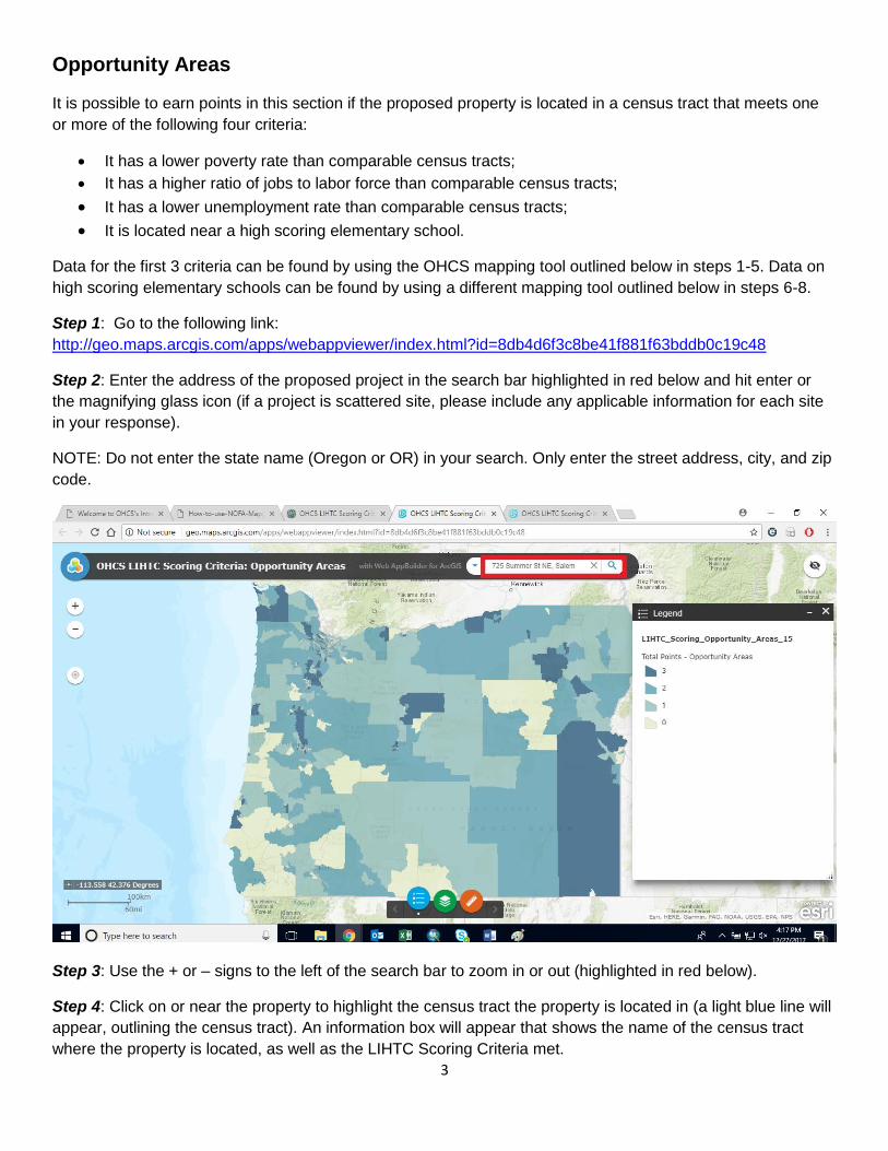
Opportunity Areas
It is possible to earn points in this section if the proposed property is located in a census tract that meets one
or more of the following four criteria:
• It has a lower poverty rate than comparable census tracts;
• It has a higher ratio of jobs to labor force than comparable census tracts;
• It has a lower unemployment rate than comparable census tracts;
• It is located near a high scoring elementary school.
Data for the first 3 criteria can be found by using the OHCS mapping tool outlined below in steps 1-5. Data on
high scoring elementary schools can be found by using a different mapping tool outlined below in steps 6-8.
Step 1: Go to the following link:
http://geo.maps.arcgis.com/apps/webappviewer/index.html?id=8db4d6f3c8be41f881f63bddb0c19c48
Step 2: Enter the address of the proposed project in the search bar highlighted in red below and hit enter or
the magnifying glass icon (if a project is scattered site, please include any applicable information for each site
in your response).
NOTE: Do not enter the state name (Oregon or OR) in your search. Only enter the street address, city, and zip
code.
Step 3: Use the + or – signs to the left of the search bar to zoom in or out (highlighted in red below).
Step 4: Click on or near the property to highlight the census tract the property is located in (a light blue line will
appear, outlining the census tract). An information box will appear that shows the name of the census tract
where the property is located, as well as the LIHTC Scoring Criteria met.

4
In the below example, the data table shows that the property is in Census Tract 2 in Marion County and that
this census tract has a high ratio of jobs to labor force (use the scroll bar on the right of the information box to
see more variables). This means that the property meets 1 out of the 3 criteria that could be mapped in this
tool for the Areas of Opportunity section. This is also clear from the color of the selected census tract, which is
the lighter shade of blue that corresponds to 1 total point according to the legend at the right of the screen.
Step 5: Return to the LIHTC Scoring Criteria Workbook provided by OHCS to select the census tract you found
using the mapping tool from the dropdown menu in the workbook (see red box below). This table can be found
in either section 8 of the 4.1BImpact (new acq rehab) or section 10 of the 4.1BImpact (preservation&PH) tabs
under Location Preferences. The table will automatically calculate the total points possible for this criteria.
NOTE: You will need to use a separate mapping tool to find the nearest elementary school to the
proposed property. See Steps 6-8 to see instructions on using this tool.

5
Step 6: Find the elementary school closest to the proposed property by going to the following link:
http://navigator.state.or.us/DHS_Schools/index.html# and entering the address of the property in the address
search bar (see box highlighted in red below).
Step 7: Look at the navigation bar on the left to find the elementary school. Each grade, K-12 is listed in
navigation bar along with the school associated with that grade. In the example below, the public elementary
school associated with the property that was searched for is Grant Community School.

6
Step 8: Return to the LIHTC Scoring Criteria Workbook provided by OHCS to select the elementary school you
found using the mapping tool from the dropdown menu in the workbook (see red box below). This table can be
found in either section 8 of the 4.1BImpact (new acq rehab) or section 10 of the 4.1BImpact (preservation&PH)
tabs under Location Preferences. The table will automatically calculate the total points possible for this criteria.