Embed Size (px)
DESCRIPTION
Using Reference3D in mapping projects. L. Falala IGN France International. Medium-scale cartography from 1/250,000 to 1/100,000. Simple process: Global DEM like SRTM or Reference3D: 30-90m resolution Medium resolution satellite images like Spot5 or Rapideye : 2.5-10m resolution - PowerPoint PPT Presentation
Citation preview

1
Using Reference3D in mapping projects
L. Falala
IGN France International

2
Medium-scale cartography from 1/250,000 to 1/100,000
Simple process:- Global DEM like SRTM or Reference3D: 30-90m resolution- Medium resolution satellite images like Spot5 or Rapideye: 2.5-10m resolution- Orthorectification of satellite images- Plotting of Geodatabase features directly on orthoimages- Map edition
Altimetric layer: Global DEM- SRTM: from 56º South to 60º North, 3” resolution (90m), freely distributed- ASTER GDEM: 99% of land areas, 1” resolution (30m), freely distributed- Reference3D: >50M km2, 1” resolution (30m), public price: 2-3 US$/km2
Cheap process: a few US$/km2 for data + processing costs
Is it accurate enough for medium-scale cartography ?
3
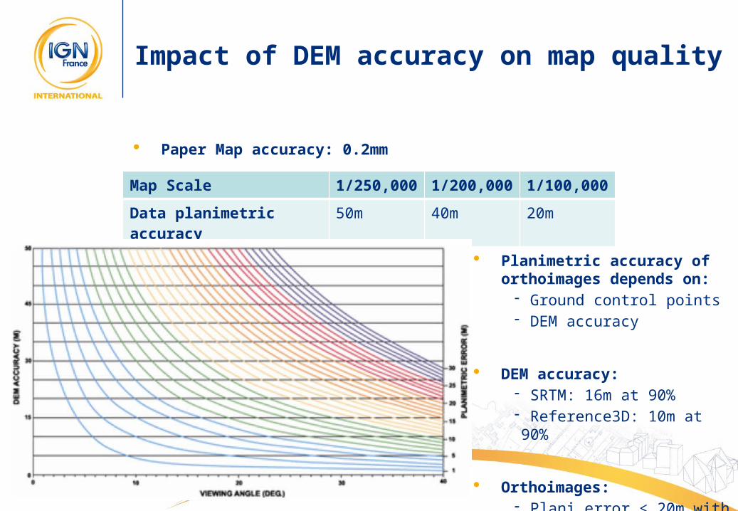
Impact of DEM accuracy on map quality
Planimetric accuracy of orthoimages depends on:
- Ground control points- DEM accuracy
DEM accuracy:- SRTM: 16m at 90%- Reference3D: 10m at 90%
Orthoimages:- Plani error < 20m with viewing angle < 40º
Map Scale 1/250,000 1/200,000 1/100,000
Data planimetric accuracy 50m 40m 20m
Paper Map accuracy: 0.2mm

4
Impact of DEM accuracy on map quality
Spot heights: altimetric accuracy = DEM accuracy
Contour interval must be aligned with DEM accuracy:- 20m interval minimum with SRTM and Reference3D
Hill shading and contour lines quality depends on:- Accurate rendering of local shapes in DEM: no blocked valleys, no rounded crests lines
- Absence of artefacts in DEM (SRTM void data)

5
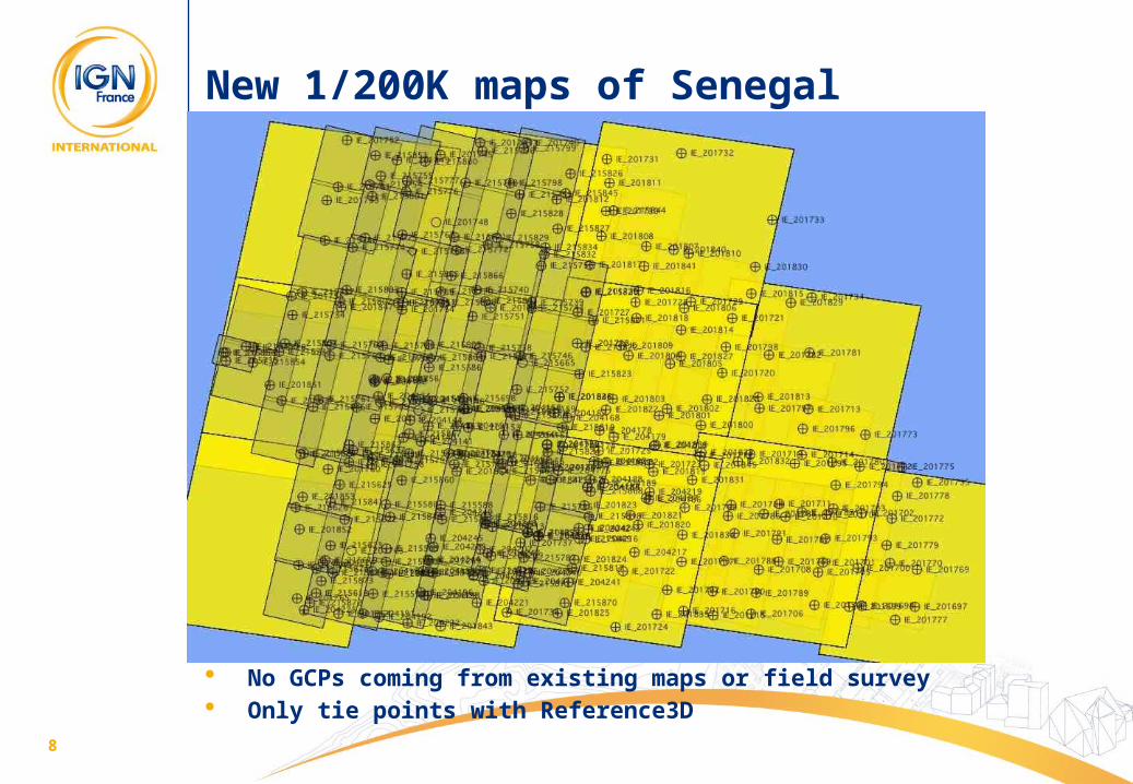
New 1/200K maps of Senegal
“PCS200” project: - Conducted in 2004-2008 by IGN-FI and mapping agency of Senegal- Financed by European Union- Production of a GeoDatabase and 27 new maps at 1/200,000
Methodology:- Altimetric reference layer: Reference3D DEM - Orthoimages calculated from Spot 5 panchromatic images at 5m and Landsat colour images at 30m
- Spot heights interpolated from DEM and distributed every 10km- Hill shading image calculated from Reference3D- Contour lines with 20m interval automatically extracted from Reference3D, automatically smoothed and manually edited

6
New 1/200K maps of Senegal
30m Reference3D DEM 20m interval contour lines

7
New 1/200K maps of Senegal
Hill shading from Reference3D DEM
8
New 1/200K maps of Senegal
No GCPs coming from existing maps or field survey Only tie points with Reference3D

9
New 1/200K maps of Senegal
Checking accuracy:- GPS points and GPS recordings of vehicles during field completion phase - Consistency of maps and GPS always better than 15m
Success of the project:- 27 maps produced in due time and within specifications- Inexpensive data + simple methodology- Know-how transfer to local institutions- EU is funding comparable mapping project in Burkina Faso in 2011

10
Old and new map of Kolda (extract)

11
Old and new map of Nioro du Rip (extract)

12
Old and new map of Kaffrine (extract)

13
Mosaic of the 27 new maps

14
Conclusion
For Medium Scale Mapping, altimetric layer can come from Reference3D
Whatever the mapping project: do not understate 3D information- Impact on what you put on the map- Impact on map accuracy
15
IGN France International39 ter, rue Gay Lussac - 75005 PARISFrance
Tél : +33 1 42 34 56 56Fax : +33 1 42 34 56 [email protected] - www.ignfi.fr
IGN France International8 rue du Sentier - 75002 PARISFrance
Tél : +33 1 42 34 56 56Fax : +33 1 42 34 56 [email protected] - www.ignfi.com
Thank you for your attention
Laurent Falala: [email protected]