Embed Size (px)
Citation preview

Using Location Analysis in Large Scale Operational Systems Siva Ravada Senior Director of Development
Spatial and Graph & MapViewer
Oracle

Copyright © 2015, Oracle and/or its affiliates. All rights reserved. |
Program Agenda
1
2
3
4
Oracle Confidential – Internal/Restricted/Highly Restricted 2
Operational systems based on DBs
Location Analysis without a GIS
APEX and Maps
Custom Hierarchical Maps

Copyright © 2015, Oracle and/or its affiliates. All rights reserved. |
Conceptual Architecture
Browser Based UI
SOA
/
Serv
ices
In
fras
tru
cure
Ap
plic
atio
ns
and
Dat
a U
ser
Inte
rfac
e
User Interface Services
Business Process Services
Connectivity & Integration Services
3rd party Applications
3rd party Applications
3rd party Applications
3rd party Applications
Oracle Applications
Bespoke Applications

Copyright © 2015, Oracle and/or its affiliates. All rights reserved. |
Browser Based UI
SOA
/ S
ervi
ces
Infr
astr
ucu
re
Ap
plic
atio
ns
and
Dat
a U
ser
Inte
rfac
e
User Interface Services
Business Process Services
Connectivity & Integration Services
3rd party Applications
3rd party Applications
3rd party Applications
3rd party Applications
3rd party Applications
Oracle Spatial – where does it fit?

Copyright © 2015, Oracle and/or its affiliates. All rights reserved. |
Example – Gas Emergency & Repair Process
Yes
No
Check Area/Location
Check Asset pipe location
& details
Act
ion
A
ctiv
itie
s C
on
trac
ts
Take details Give advice Input information
0800 111 999 Identify ESE Send job
Attend Site Make safe
Call repair crew Repair and restore supply
Is the ESE working on his own DN asset?
Process takes account for DN attending another transporters escape
ESE remains on site until relieved by another ESP
First responsibility of the ESE is to protect life & property, irrespective of the asset owner
Manage work Closure & info
capture
Incident Reported
Handle Call
Dispatch work
Attend site
Repair or
Plan work
Customer
CSR Contractor Biz Analysts Regional Manager
Internet
Call Center
Internet
Internet Wireless
Contractor
Oracle Apps CIS BPM Simulation Dispatch Documents Procedures
Shared Business Services
User Interface Services – Portal, Wireless, Radio
Service Orchestration
Dispatcher
Wireless Wireless

Copyright © 2015, Oracle and/or its affiliates. All rights reserved. |
Example – Gas Emergency & Repair Process
Yes
No
Check Area/Location
Check Asset pipe location
& details
Act
ion
A
ctiv
itie
s C
on
trac
ts
Take details Give advice Input information
0800 111 999 Identify ESE Send job
Attend Site Make safe
Call repair crew Repair and restore supply
Is the ESE working on his own DN asset?
Process takes account for DN attending another transporters escape
ESE remains on site until relieved by another ESP
First responsibility of the ESE is to protect life & property, irrespective of the asset owner
Manage work Closure & info
capture
Incident Reported
Handle Call
Dispatch work
Attend site
Repair or
Plan work
Customer CSR Contractor Biz Analysts Regional Manager
Internet
Call Center
Internet
Internet Wireless
Contractor
Shared Business Services
User Interface Services – Portal, Wireless, Radio
Service Orchestration
Dispatcher
Wireless Wireless
Customer call Emergency Gas Escape
Oracle Apps CIS BPM Simulation Dispatch Documents Procedures
SPATIALLY-ENABLED ORACLE DATABASE

Copyright © 2015, Oracle and/or its affiliates. All rights reserved. |
Example – Gas Emergency & Repair Process
Yes
No
Check Area/Location
Check Asset pipe location
& details
Act
ion
A
ctiv
itie
s C
on
trac
ts
Take details Give advice Input information
0800 111 999 Identify ESE Send job
Attend Site Make safe
Call repair crew Repair and restore supply
Is the ESE working on his own DN asset?
Process takes account for DN attending another transporters escape
ESE remains on site until relieved by another ESP
First responsibility of the ESE is to protect life & property, irrespective of the asset owner
Manage work Closure & info
capture
Incident Reported
Handle Call
Dispatch work
Attend site
Repair or
Plan work
Customer CSR Contractor Biz Analysts Regional Manager
Internet
Call Center
Internet
Internet Wireless
Contractor
Oracle Apps CIS BPM Simulation Dispatch Documents Procedures
Shared Business Services
User Interface Services – Portal, Wireless, Radio
Service Orchestration
Dispatcher
Wireless Wireless
Customer call Emergency Gas Escape
Raise Emergency Job • Register contact & problem • Eliminate duplicate incidents • Identify responsible party
Display Map • Customers • Assets • Jobs & their status •Territories / LDZ
Map Rendering Service Identify Location • Determine coordinates
of Incident location
Geocoding Service
Determine Territory • Inside which LDZ is the
incident located?
Spatial Query Service
Capture Location • Create a point feature
representing the incident • Location of all incidents
stored persistently
Create Feature Service
Intuitive map-based interface - Customer is at the centre of the process Call Handling
SPATIALLY-ENABLED ORACLE DATABASE

Copyright © 2015, Oracle and/or its affiliates. All rights reserved. |
Example – Gas Emergency & Repair Process
Yes
No
Check Area/Location
Check Asset pipe location
& details
Act
ion
A
ctiv
itie
s C
on
trac
ts
Take details Give advice Input information
0800 111 999 Identify ESE Send job
Attend Site Make safe
Call repair crew Repair and restore supply
Is the ESE working on his own DN asset?
Process takes account for DN attending another transporters escape
ESE remains on site until relieved by another ESP
First responsibility of the ESE is to protect life & property, irrespective of the asset owner
Manage work Closure & info
capture
Incident Reported
Handle Call
Dispatch work
Attend site
Repair or
Plan work
Customer CSR Contractor Biz Analysts Regional Manager
Internet
Call Center
Internet
Internet Wireless
Contractor
Oracle Apps CIS BPM Simulation Dispatch Documents Procedures
Shared Business Services
User Interface Services – Portal, Wireless, Radio
Service Orchestration
Dispatcher
Wireless Wireless
Create Emergency Job • Copy incident details into job • Assess worker safety • Assess risk of hazard • Identify opportunistic jobs
Find nearby risks • Find places of interest (schools,
transportation infrastructure, traffic routes, etc.) close to emergency job location
Spatial Query Service
Find opportunistic jobs • Find unallocated job(s)
nearby
Spatial Query Service
Optimised scheduling - More efficient, safer operations
Schedule
SPATIALLY-ENABLED ORACLE DATABASE

Copyright © 2015, Oracle and/or its affiliates. All rights reserved. |
Example – Gas Emergency & Repair Process
Yes
No
Check Area/Location
Check Asset pipe location
& details
Act
ion
A
ctiv
itie
s C
on
trac
ts
Take details Give advice Input information
0800 111 999 Identify ESE Send job
Attend Site Make safe
Call repair crew Repair and restore supply
Is the ESE working on his own DN asset?
Process takes account for DN attending another transporters escape
ESE remains on site until relieved by another ESP
First responsibility of the ESE is to protect life & property, irrespective of the asset owner
Manage work Closure & info
capture
Incident Reported
Handle Call
Dispatch work
Attend site
Repair or
Plan work
Customer CSR Contractor Biz Analysts Regional Manager
Internet
Call Center
Internet
Internet Wireless
Contractor
Oracle Apps CIS BPM Simulation Dispatch Documents Procedures
Shared Business Services
User Interface Services – Portal, Wireless, Radio
Service Orchestration
Dispatcher
Wireless Wireless
Update Emergency Job & Tasks
• Assign job to engineer • Send job location, maps, route to engineer
Identify Resources • Find closest engineer based upon
street-level routing • Prepare route • Determine journey-time
Routing Service
Generate Map(s) • Location of job & assets • Supporting information e.g. job
history, switches, etc Map Rendering Service
Optimised dispatch - Field-based staff with right information Dispatch
SPATIALLY-ENABLED ORACLE DATABASE

Copyright © 2015, Oracle and/or its affiliates. All rights reserved. |
Example – Gas Emergency & Repair Process
Yes
No
Check Area/Location
Check Asset pipe location
& details
Act
ion
A
ctiv
itie
s C
on
trac
ts
Take details Give advice Input information
0800 111 999 Identify ESE Send job
Attend Site Make safe
Call repair crew Repair and restore supply
Is the ESE working on his own DN asset?
Process takes account for DN attending another transporters escape
ESE remains on site until relieved by another ESP
First responsibility of the ESE is to protect life & property, irrespective of the asset owner
Manage work Closure & info
capture
Incident Reported
Handle Call
Dispatch work
Attend site
Repair or
Plan work
Customer CSR Contractor Biz Analysts Regional Manager
Internet
Call Center
Internet
Internet Wireless
Contractor
Oracle Apps CIS BPM Simulation Dispatch Documents Procedures
Shared Business Services
User Interface Services – Portal, Wireless, Radio
Service Orchestration
Dispatcher
Wireless Wireless Capture Location • Update job location
Create Feature Service
Identify Location • Determine actual coordinates
of job
Geocoding Service
Investigate Emergency Job & Update • On-site risk assessment • Correct/improve information received • Make safe or create repair job
One “job” updated throughout its life cycle
Attend Site
SPATIALLY-ENABLED ORACLE DATABASE

Copyright © 2015, Oracle and/or its affiliates. All rights reserved. |
Example – Gas Emergency & Repair Process
Yes
No
Check Area/Location
Check Asset pipe location
& details
Act
ion
A
ctiv
itie
s C
on
trac
ts
Take details Give advice Input information
0800 111 999 Identify ESE Send job
Attend Site Make safe
Call repair crew Repair and restore supply
Is the ESE working on his own DN asset?
Process takes account for DN attending another transporters escape
ESE remains on site until relieved by another ESP
First responsibility of the ESE is to protect life & property, irrespective of the asset owner
Manage work Closure & info
capture
Incident Reported
Handle Call
Dispatch work
Attend site
Repair or
Plan work
Customer CSR Contractor Biz Analysts Regional Manager
Internet
Call Center
Internet
Internet Wireless
Contractor
Shared Business Services
User Interface Services – Portal, Wireless, Radio
Service Orchestration
Dispatcher
Wireless Wireless
Execute Work
Update Repair Job & Tasks – Create Confirmations
• Report Time & Material consumed • Feedback work details
Capture Redlining • Store network changes as spatial
features • Job status indicates need for
network updates
Create Feature Service
Identify Location • Determine location of actual work
Geocoding Service
Capture Location • Update job location
Create Feature Service
Accurate data capture – Improved network management
Oracle Apps CIS BPM Simulation Dispatch Documents Procedures
SPATIALLY-ENABLED ORACLE DATABASE

Copyright © 2015, Oracle and/or its affiliates. All rights reserved. |
Example – Gas Emergency & Repair Process
Yes
No
Check Area/Location
Check Asset pipe location
& details
Act
ion
A
ctiv
itie
s C
on
trac
ts
Take details Give advice Input information
0800 111 999 Identify ESE Send job
Attend Site Make safe
Call repair crew Repair and restore supply
Is the ESE working on his own DN asset?
Process takes account for DN attending another transporters escape
ESE remains on site until relieved by another ESP
First responsibility of the ESE is to protect life & property, irrespective of the asset owner
Manage work Closure & info
capture
Incident Reported
Handle Call
Dispatch work
Attend site
Repair or
Plan work
Customer CSR Contractor Biz Analysts Regional Manager
Internet
Call Center
Internet
Internet Wireless
Contractor
Shared Business Services
User Interface Services – Portal, Wireless, Radio
Service Orchestration
Dispatcher
Wireless Wireless
Manage work Closure & info capture
Oracle Apps CIS BPM Simulation Dispatch Documents Procedures
SPATIALLY-ENABLED ORACLE DATABASE

Copyright © 2015, Oracle and/or its affiliates. All rights reserved. |
Spatial Analysis in the System
Raise Emergency Job • Register contact & problem • Eliminate duplicate incidents • Identify responsible party
Display Map • Customers • Assets • Jobs & their status •Territories / LDZ
Map Rendering Service Identify Location • Determine coordinates
of Incident location
Geocoding Service
Determine Territory • Inside which LDZ is the
incident located?
Spatial Query Service
Capture Location • Create a point feature
representing the incident • Location of all incidents
stored persistently
Create Feature Service
Intuitive map-based interface - Customer is at the centre of the process
Create Emergency Job • Copy incident details into job • Assess worker safety • Assess risk of hazard • Identify opportunistic jobs
Find nearby risks • Find places of interest (schools,
transportation infrastructure, traffic routes, etc.) close to emergency job location
Spatial Query Service
Find opportunistic jobs • Find unallocated job(s) nearby
Spatial Query Service
Optimised scheduling - More efficient, safer operations
Update Repair Job & Tasks – Create Confirmations
• Report Time & Material consumed • Feedback work details
Capture Redlining • Store network changes as spatial
features • Job status indicates need for
network updates
Create Feature Service
Identify Location • Determine location of actual work
Geocoding Service
Capture Location • Update job location
Create Feature Service
Accurate data capture – Improved network management
Copyright © 2015, Oracle and/or its affiliates. All rights reserved. |
Program Agenda
1
2
3
4
Oracle Confidential – Internal/Restricted/Highly Restricted 14
Operational systems based on DBs
Location Analysis without a GIS
APEX and Maps
Custom Hierarchical Maps

Copyright © 2015, Oracle and/or its affiliates. All rights reserved. |
Spatial in DB
Spatial Indexing
Fast Access to Spatial Data
Spatial Analysis Through SQL
Oracle Spatial Technology in the DB
SELECT a.customer_name, a.phone_number
FROM policy_holders a
WHERE sdo_within_distance( a.geom, hurricane_path_geom,
‘distance = 10 unit = mile’) = ‘TRUE’;
Spatial Data Types
All Spatial Data Stored in the Database
f1
f2 n1
n2
e1
e2
e3
e4

Copyright © 2015, Oracle and/or its affiliates. All rights reserved. |
Extend Spatial functionality with PL/SQL Web Services
• PL/SQL packaged functions can be exposed as simple web services
• Easy to develop XML-based protocol for accessing services on the Web by using XML syntax to send commands over HTTP
• JDeveloper provides many features to help create and deploy web services
• These web services can be deployed in any J2EE container or APEX
• These are useful to expose specific database search or DML operations are web services to other components in a system
Simple Search and DML interfaces

Copyright © 2015, Oracle and/or its affiliates. All rights reserved. |
Simple Search Example
CREATE FUNCTION FIND_NEARBY_RISKS( LONGITUDE NUMBER, LATITUDE NUMBER) RETURN VARCHAR2
AS
Result varchar2(3000);
BEGIN
SELECT XMLELEMENT( … xmlagg(feature_name) …) into result
FROM features_of_interest a
WHERE SDO_ANYINTERACT(a.geometry,
sdo_geometry(2001,8307, sdo_point_type(longitude,latitude,null), null, null)) = ‘TRUE’;
return result;
END;
Create a PL/SQL function

Copyright © 2015, Oracle and/or its affiliates. All rights reserved. |
Publishing and Using the web service
• JDeveloper makes it easy to take the PL/SQL function and publish it a s web service
– No code require, all widget driven
– OTN Jdeveloper pages have examples
• Use HTTP GET methods to use the service – http://localhost/getNearbyRisks?long=-121.34&lat=37
– This will return an XML document with potential features of interest that are at risk near the incident location
• These type of services are easy to integrate into the workflow of a system that requires results based on spatial searches

Copyright © 2015, Oracle and/or its affiliates. All rights reserved. |
Simple DML Example
CREATE FUNCTION CREATE_INCIDENT( LONGITUDE NUMBER, LATITUDE NUMBER) RETURN VARCHAR2 AS
Result incident_number;
BEGIN
incident_number := service_incidents_seq.nextVal;
INSERT INTO service_incidents values (incident_number,
sdo_geometry(2001,8307, sdo_point_type(longitude,latitude,null), null, null)) ;
commit;
return incident_number;
END;
Create a PL/SQL function

Copyright © 2015, Oracle and/or its affiliates. All rights reserved. |
Publishing and Using the web service
• A field technician wants to report an incident at a certain location
• Use HTTP PUT method to use the service
– http://localhost/createIncident –d “{longitude: -121.37 longitude: 37}”
– This will create an entry in the incidents table and trigger an event to generate a service request to process the event
– Database triggers should be used to automatically trigger these services requests based on the incidents
Copyright © 2015, Oracle and/or its affiliates. All rights reserved. |
Provide Spatial analytics as web services
• Do not need to have SQL access to add spatial capabilities to an application
• Many times simple spatial search interfaces can integrated into different components of a system using PL/SQL based web services
• Don’t need a separate GIS system if the application does not have direct access to the Spatial database
• Use the database services as much as possible to truly take advantage of enterprise wide spatial data
Copyright © 2015, Oracle and/or its affiliates. All rights reserved. |
Program Agenda
1
2
3
4
Oracle Confidential – Internal/Restricted/Highly Restricted 22
Operational systems based on DBs
Location Analysis without a GIS
APEX and Maps
Custom Hierarchical Maps
Copyright © 2015, Oracle and/or its affiliates. All rights reserved. |
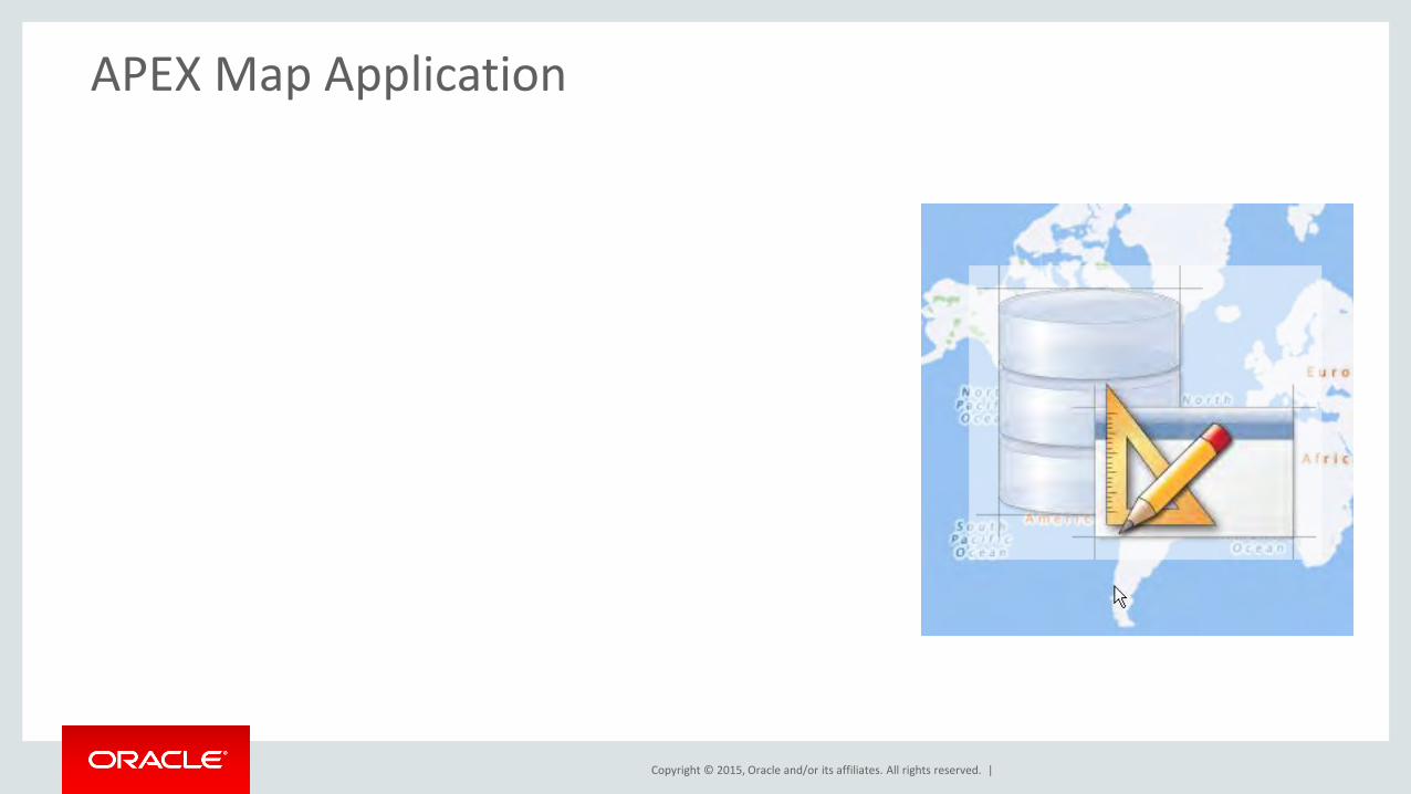
APEX Map Application

Copyright © 2015, Oracle and/or its affiliates. All rights reserved. |
Spatial enabled Applications in APEX • Spatial data in tables
– First approach: two NUMBER columns
– What about lines and polygons?
• Spatial processing – SQL, PL/SQL
• Visualization on a map
• Adding new spatial data via the browser
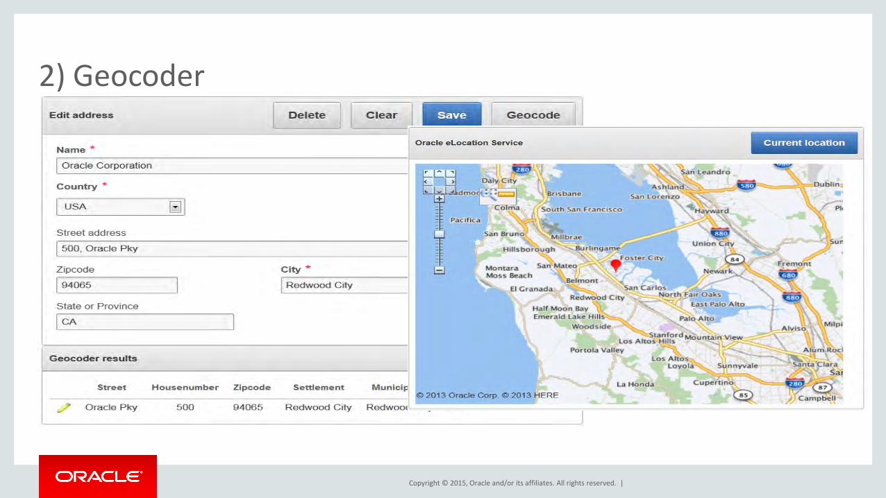
• Geocoding
• Spatial queries: – Within Distance
– Nearest Neighbors
– Spatial Intersections

Copyright © 2015, Oracle and/or its affiliates. All rights reserved. |
1) Map
Copyright © 2015, Oracle and/or its affiliates. All rights reserved. |
2) Geocoder

Copyright © 2015, Oracle and/or its affiliates. All rights reserved. |
3) Spatial Query: Within Distance

Copyright © 2015, Oracle and/or its affiliates. All rights reserved. |
4) Spatial Query: Anyinteract

Copyright © 2015, Oracle and/or its affiliates. All rights reserved. |
APEX and the Database provide everything you need ...
• Spatial Data Type: SDO_GEOMETRY
• Spatial functions in SQL and PL/SQL
• Oracle eLocation Map Service
• Oracle eLocation Geocoder Service
• APEX plugins and widgets
• APEX Sample application

Copyright © 2015, Oracle and/or its affiliates. All rights reserved. |
Sample Geolocation Showcase

Copyright © 2015, Oracle and/or its affiliates. All rights reserved. |
Oracle Maps Utility Plugins

Copyright © 2015, Oracle and/or its affiliates. All rights reserved. |
Spatial data Step 1

Copyright © 2015, Oracle and/or its affiliates. All rights reserved. |
Create a table for spatial data
create table my_spatial_images( id number(10) not null, image blob, thumbnail blob, file_name varchar2(200) not null, mimetype varchar2(200), geometry sdo_geometry, exif xmltype, datetime timestamp with time zone, constraint my_spatial_images_pk primary key (id) )
• Can store points, lines, polygons and complex geometries • Database provides indexing, query and processing capabilities

Copyright © 2015, Oracle and/or its affiliates. All rights reserved. |
Spatial tables need additional tasks
begin -- create metadata for spatial table -- coordinates are lon/lat – and over the whole world apex_spatial.insert_geom_metadata_lonlat( p_table_name => 'MY_SPATIAL_IMAGES', p_column_name => 'GEOMETRY' ); end; create index MY_SPATIAL_IMAGES_SX on MY_SPATIAL_IMAGES (GEOMETRY) indextype is MDSYS.SPATIAL_INDEX
• Maintain spatial metadata • Create an index mandatory for spatial queries

Copyright © 2015, Oracle and/or its affiliates. All rights reserved. |
Visualization on a map Step 2

Copyright © 2015, Oracle and/or its affiliates. All rights reserved. |
Architecture
Oracle eLocation Service with Map Database
APEX database
Client Browser Background Maps
Geocoding
Reverse Geocoding
APEX Pages and
objects to be
shown on the map
Copyright © 2015, Oracle and/or its affiliates. All rights reserved. |
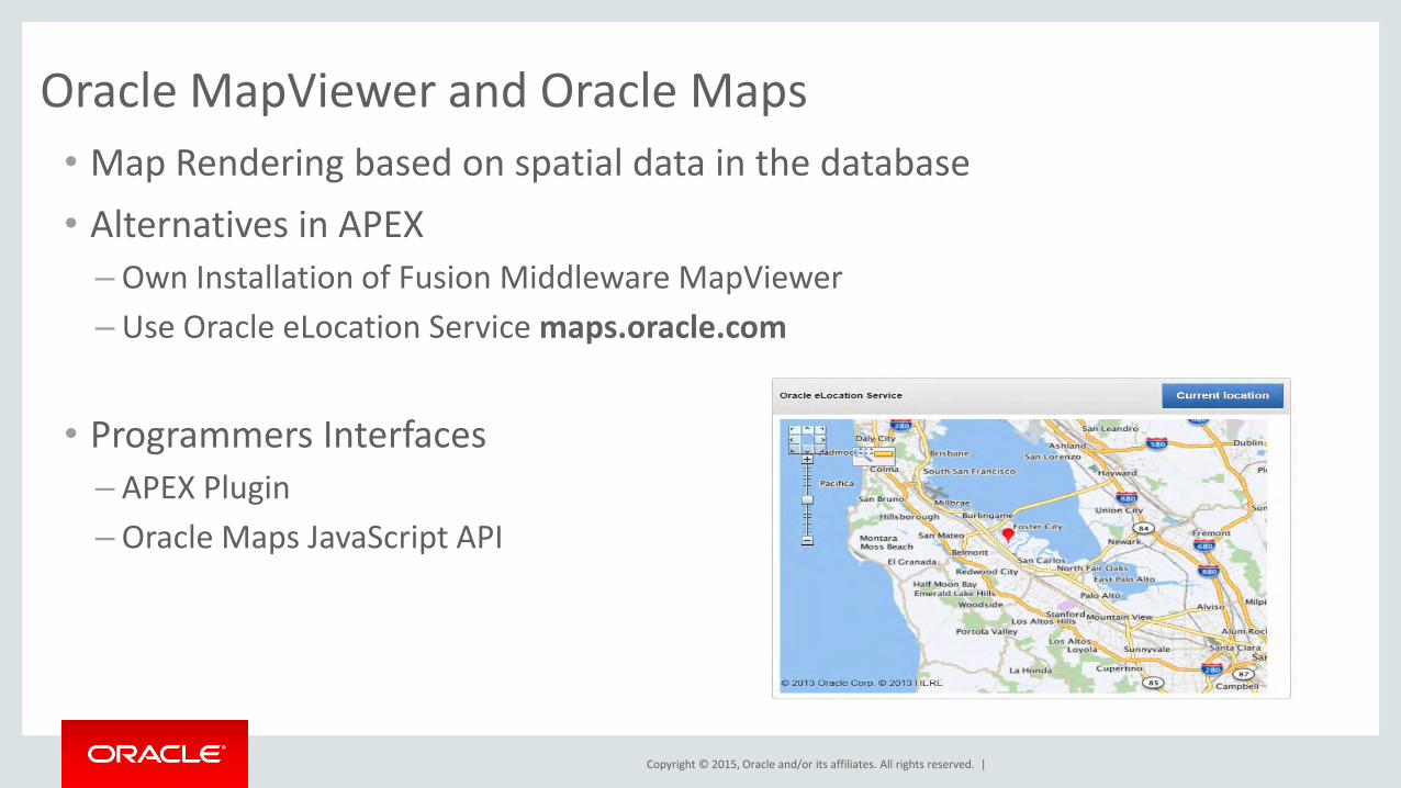
Oracle MapViewer and Oracle Maps
• Map Rendering based on spatial data in the database
• Alternatives in APEX
– Own Installation of Fusion Middleware MapViewer
– Use Oracle eLocation Service maps.oracle.com
• Programmers Interfaces
– APEX Plugin
– Oracle Maps JavaScript API

Copyright © 2015, Oracle and/or its affiliates. All rights reserved. |
Oracle Maps APEX Plugin

Copyright © 2015, Oracle and/or its affiliates. All rights reserved. |
Spatial query and analysis
Step 3

Copyright © 2015, Oracle and/or its affiliates. All rights reserved. |
Within Distance Search
• WHERE Clause: SDO_WITHIN_DISTANCE
• Geometry column must be spatially indexed
• Input Parameters
• Geometry column to search in
• Search Geometry
• Distance
• Unit to use

Copyright © 2015, Oracle and/or its affiliates. All rights reserved. |
Nearest Neighbor Search
• WHERE Clause: SDO_NN
• Geometry column must be spatially indexed
• Input Parameters
• Geometry column to search in
• Start geometry
• Maximum Distance
• Max. neighbors
• Unit to use
select * from feature_table t where sdo_nn( t.geometry, start_geometry, 'distance=XX unit=km' ) = 'TRUE'

Copyright © 2015, Oracle and/or its affiliates. All rights reserved. |
Build your own application

Copyright © 2015, Oracle and/or its affiliates. All rights reserved. |
Your own application ...

Copyright © 2015, Oracle and/or its affiliates. All rights reserved. |
APEX and the Database But you can go further ...
• Use your own map server ...
• Use own map styles or own map data
• Deep Integration between database and map server
• Use your own geocoding facility
• Geocoder directly embedded in the database
• No HTTP requests any more
And you can still use the APEX plugins and widgets

Copyright © 2015, Oracle and/or its affiliates. All rights reserved. |
Program Agenda
1
2
3
4
Oracle Confidential – Internal/Restricted/Highly Restricted 46
Operational systems based on DBs
Location Analysis without a GIS
APEX and Maps
Custom Hierarchical Maps

Copyright © 2015, Oracle and/or its affiliates. All rights reserved. |
Hierarchical Report Generation
• Requirement
– Generate reports and maps using custom or standard geographic entities
– Provide drill down and drill up capabilities
– Hierarchy can be geometry based or name based
• Solution
– Use MapViewer for maps and reports
– Use commercial or open source data sets to build the hierarchies
– And associate these hierarchies with the application data

Copyright © 2015, Oracle and/or its affiliates. All rights reserved. |
Hierarchy Examples
• Customer locations have an address
– Find the aggregate information for all customers in a city/county/state/country
– Map interface to drill up and drill down to navigate through the hierarchy and visualize the aggregate information at different levels

Copyright © 2015, Oracle and/or its affiliates. All rights reserved. |
Creating Hierarchical Data Model
• Many data sources available for coarse level admin area boundary data
– Oracle bundles HERE data (certain levels of administrative boundaries) sets with the database
– Open source data sets are also readily available
• Create a COUNTRY_HIERARCHY table with these columns
(AREA_ID, NAME, ADMIN_LEVEL, PARENT_AREA_ID, GEOMETRY)
• Populate the parent_area_id column using SDO_RELATE operations

Copyright © 2015, Oracle and/or its affiliates. All rights reserved. |
Using Hierarchical Data Model
• Associate each customer with the lowest level of the hierarchy
– In this example, lets say city is at level 4, county at level 3, etc.
– Associate the customer records with the city level admin area
• Once this hierarch is established it is easy to calculate aggregate metrics for different customer attributes at different admin areas
• Using SQL it is then easy to find the number of customers in each city/county/state/country
• MapViewer api can be used to define themes that will show aggregate customer data at each level of the hierarchy
• All of this can be done dynamically on the operational data
Geometry based hierarchy

Copyright © 2015, Oracle and/or its affiliates. All rights reserved. |
Custom Hierarchies
• Users want to create own geometry regions
• Define hierarchies based on user defined collections of geometries
• Hierarchies are defined based on business rules and do not necessary follow admin hierarchies
• Examples: postal_codes/sales_territories/sales_regions, etc.
Geometry hierarchy

Copyright © 2015, Oracle and/or its affiliates. All rights reserved. |
Custom Hierarchies
Data editing tools Session (spatial)
content and state
Data sources and session settings

Copyright © 2015, Oracle and/or its affiliates. All rights reserved. |
MapViewer
• A web-based spatial data editing tool (java applet)
• Supports versioned, concurrent editing through editing sessions
• Supports Workspace Manager • Supports geometry model • All aspects of an editing session are
saved in database
Web-based Editor

Copyright © 2015, Oracle and/or its affiliates. All rights reserved. |
The Spatial & Graph SIG User Group
• The SIG promotes interaction and communication that can drive the market for spatial technology and data
• Members connect and exchange knowledge via online communities and at annual conferences and events
• Meet us here at the Summit
Morning Reception Tuesday and Wednesday 7:45 to 8:30 a.m. Registration Area
Social Hours Tuesday and Wednesday 6 to 7 p.m. Registration Area
• Join us online – LinkedIn (search for “LinkedIn Oracle Spatial”) – Google+ (search for “Google+ Oracle Spatial”) – IOUG SIG (sign up for free membership through
www.ioug.org) – OTN Spatial – Communities (search for “Oracle
Spatial and Graph Community”) • Contact the Board at [email protected]

Copyright © 2015, Oracle and/or its affiliates. All rights reserved. |
Resources: Oracle Technology Network
• www.oracle.com/technetwork/database/options/spatialandgraph
• www.oracle.com/technetwork/middleware/mapviewer
• blogs.oracle.com oraclespatial oracle_maps_blog

Copyright © 2015, Oracle and/or its affiliates. All rights reserved. |
More Resources

Copyright © 2015, Oracle and/or its affiliates. All rights reserved. |
Certification
• Individual Certification, Partner Specialization
– Credentials for individuals with Spatial implementation expertise
– OPN Specialization – differentiates partner organizations delivering Spatial services
– Study materials, exam information, program guidelines are available at www.oracle.com/technetwork/database/options/ spatialandgraph/learnmore/spatial-partners-423197.html
- Talk to Oracle team this week

Copyright © 2015, Oracle and/or its affiliates. All rights reserved. |
Q & A