Embed Size (px)
Citation preview

Shota Chachkhunashvili (National Agency of Public Registry, Georgia)Mikheil Tsiklauri (Geographic, Georgia)
San Diego, 2008
Using ArcGIS Server for National Property Information System

National Agency of Public Registry, Georgia
Geographic LTD, International Distributor of ESRI in Georgia
About us

Database Server – Oracle10g2r
Operating System – Windows 2003 Server
ArcGIS Server 9.2 Enterprise Standard – 1 license
Client – ArcEditor 9.2 - 31 licensesArcView 9.2 - 29 licensesWeb BrowsersCustom Application
Software and database used

System Design
OracleSDE
Oracle
SOMSOMSOCSOC
ArcGISArcGISServerServer
Web Server
ArcView ArcView ArcView
Service ...
Web Browser
Web browser
Web browser
Analytics
Web Browser
Web browser
Web browser
Registrations
Central Office
Tbilisi OfficeWeb browser
Web browser
Web browser
Internet
ArcEditor ArcEditor ArcEditor
Operators
District Office District Office District OfficeRegistrations, Operators,
ServiceRegistrations, Operators,
ServiceRegistrations, Operators,
Service

Registration Client Application – Delphi, Web Service
Cadastral Operator Group – ArcEditor, VBA Scripts, ArcObjects
Customer Service Application – ArcView, VBA Scripts, ArcObjects
Web Mapping Application – ArcGIS Server, Visual Studio 2005 – VB.Net
Client Applications and Software

Registration of Private Property
Step 1. Customer applies necessary documents
Step 2. Operator registers the application through the Registration Application and registration process starts

Registration of Private Property
Step 3. Cadastral operator group receives spatial data of target property object (Shp Files)
Step 4. Cadastral operator group inputs spatial data into SDE geodatabase
OracleSDE

Registration of Private PropertyStep 5. VBA Scripts automatically gave to the parcel unique code and the status and generate cadastral map in pdf format
Step 6. Cadastral operator group attach this cadastral map to the database using custom web application
Step 6. Cadastral operator group uploads cadastral map to the database using custom web application

Registration of Private Property
Step 6. Registrar begins registration process using registrationsoftware and all necessary data
Step 7. Registrar makes decision and gives status to the property. The status of the corresponding parcel will be automatically updated

Registration of Private PropertyStep 8. If documents fulfill all requirements, the registered parcel will appear in the web mapping application through the internet.
If any of the requirements are not fulfilled, registration process will start from the beginning

Registration of Private PropertyDuring the registration process the customer can observe the status of his application on the web application
.....
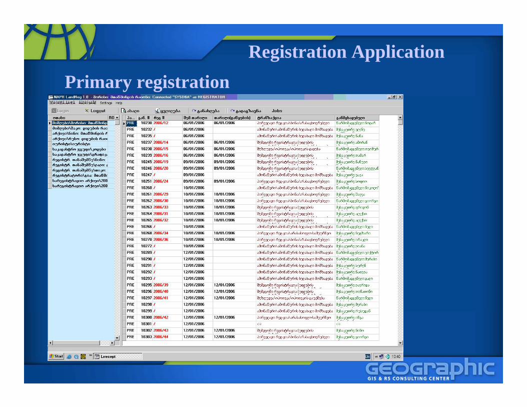
Registration ApplicationPrimary registration

Registration ApplicationNew Application

Registration ApplicationWhole Application in Reception

Registration ApplicationCadastral codes/address module

Registration ApplicationCadastral Map Module

Client Application for Cadastral Operator GroupArcGIS Desktop – ArcEditor LicenseCustom VBA scripts using ArcObject, easier working with orthophotoes

Client Application for Cadastral Operator GroupGeodatabase History

Client Application for Service Operator Group
ArcGIS Desktop – ArcView License
Custom VBA scripts using ArcObject
Automatic Generation of Custom Cadastral Maps and Plans

Web mapping application
Tbilisi cadastral map with standard tools:Search,ZoomIn, ZoomOut,Pan, Identify, Measure, Back,MapView, Navigation.
public.reestri.gov.ge/cadmap
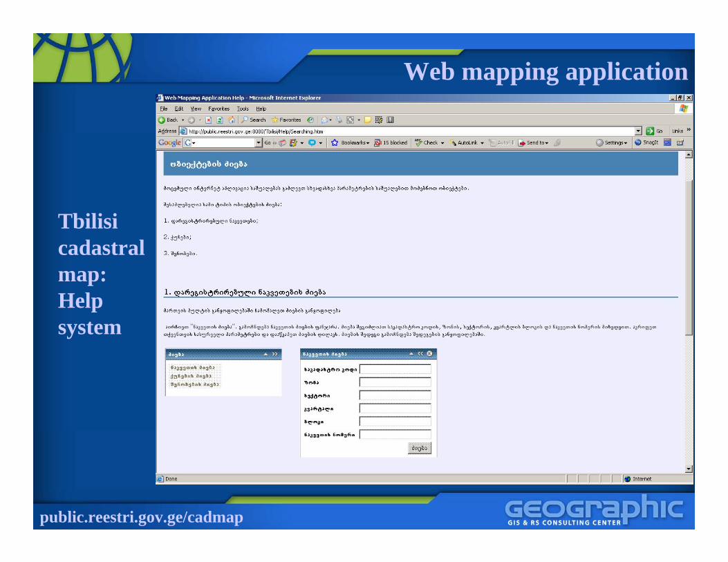
Web mapping application
Tbilisi cadastral map:Help system
public.reestri.gov.ge/cadmap

Web mapping application
Tbilisi cadastral map:Search system –Parcels, Streets, Buildings by address and parcel code
public.reestri.gov.ge/cadmap

Web mapping applicationTbilisi cadastral map: legal documents – cadastral extract and map
public.reestri.gov.ge/cadmap

Web mapping application
Tbilisi cadastral map:Direct download legal documentsvia the internet
public.reestri.gov.ge/cadmap
Cadastral extract Cadastral map

Web mapping application
Tbilisi cadastral map:1. Initial Authorization
2. Authorized User Name and Password check
public.reestri.gov.ge/cadmap

Web mapping application
Tbilisi cadastral map:
Buy spatial data through the web payment
public.reestri.gov.ge/cadmap

Web mapping application
Tbilisi cadastral map: Web payment
public.reestri.gov.ge/cadmap
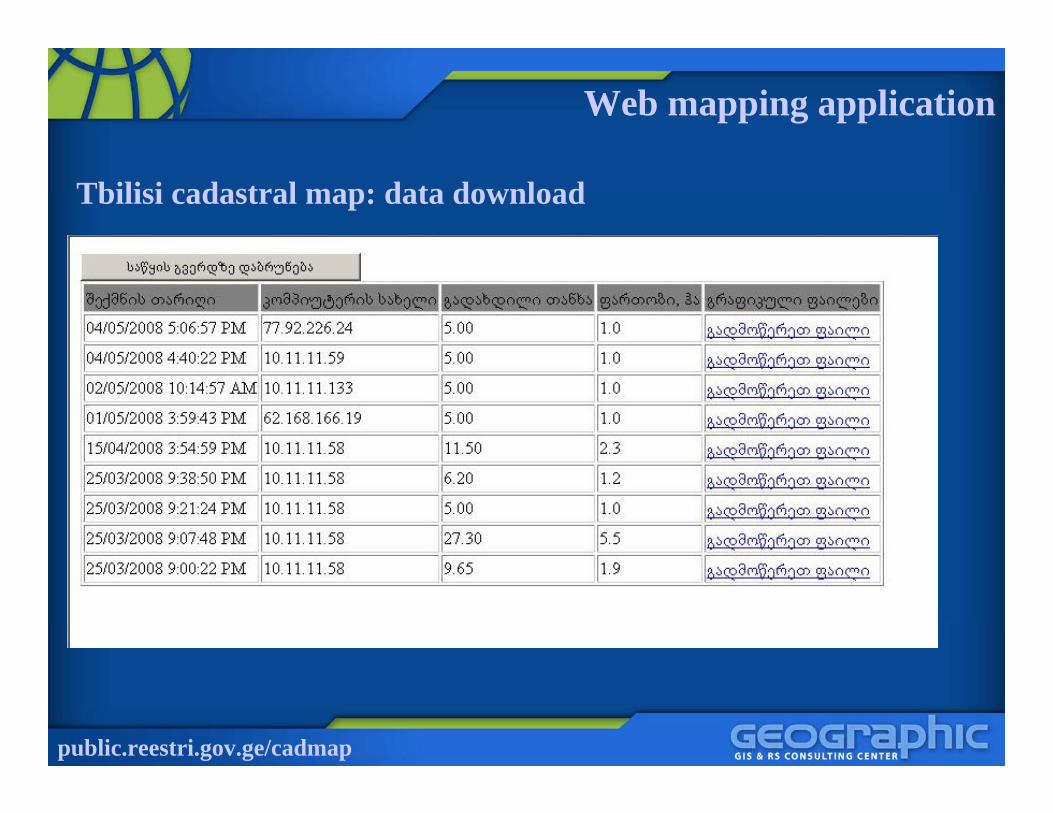
Web mapping application
Tbilisi cadastral map: data download
public.reestri.gov.ge/cadmap

Current works
Current works:
public.reestri.gov.ge/cadmap
Client Application for Cadastral Group– Will be developed using ArcEngine– Fully automated functionalities– High level of security

Thank you for your attention


![[eBook] GIS - Esri - ArcGIS - Complete Manual](https://img.dokumen.tips/doc/110x75/5572018f4979599169a1dad6/ebook-gis-esri-arcgis-complete-manual.jpg)