Embed Size (px)
Citation preview

Using ArcGIS for Statewide Using ArcGIS for Statewide Geosciences ApplicationsGeosciences Applications
Visualizing, Managing, and Analyzing Spatial Data Visualizing, Managing, and Analyzing Spatial Data Related toRelated to Geological Hazards and ResourcesGeological Hazards and Resources
Mike Chenevey
Geology Symposium 2007May 10 ● Sacramento

ESRI – GeoSym 2007
GIS BackgroundGIS Background
““Geographic Information SystemsGeographic Information Systems,,”” in the digital in the digital sense, have been around for over 50 yearssense, have been around for over 50 years
ESRIESRI, largest GIS software company in the world, , largest GIS software company in the world, was was founded in 1969founded in 1969 by Jack & Laura Dangermondby Jack & Laura Dangermond
Today we have over Today we have over 1 Million users1 Million users worldwideworldwide

ESRI – GeoSym 2007
GIS BackgroundGIS Background
An An enormous range of GIS usersenormous range of GIS users exist:exist:
Banking and financeBanking and finance EngineeringEngineeringLarge retailersLarge retailers GovernmentGovernmentMedia & pressMedia & press TransportationTransportationReal estateReal estate UtilitiesUtilitiesDefenseDefense Natural resourcesNatural resourcesEducationEducation

ESRI – GeoSym 2007
How is a GIS used?How is a GIS used?
•• VisualizationVisualization•• AnalysisAnalysis•• Spatial data managementSpatial data management
ESRI – GeoSym 2007
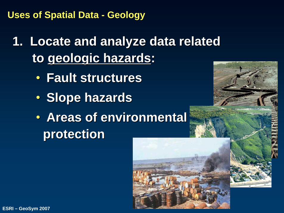
Uses of Spatial Data Uses of Spatial Data -- GeologyGeology
1. Locate and analyze data related 1. Locate and analyze data related to to geologic hazardsgeologic hazards::•• Fault structuresFault structures•• Slope hazardsSlope hazards•• Areas of environmental Areas of environmental
protectionprotection

ESRI – GeoSym 2007
Uses of Spatial Data Uses of Spatial Data -- GeologyGeology
2.2. Locate and analyze Locate and analyze geologic resourcesgeologic resources::•• Rock and mineral occurrencesRock and mineral occurrences•• Areas of mining activity (both historical Areas of mining activity (both historical
and current)and current)

ESRI – GeoSym 2007
Uses of Spatial Data Uses of Spatial Data -- GeologyGeology
3. 3. CollaborateCollaborate with:with:•• Other agencies (local, state, federal)Other agencies (local, state, federal)•• Professional consultantsProfessional consultants•• Private personsPrivate persons
InvolvesInvolves: data sharing, quality control, : data sharing, quality control, and promotion of knowledge transferand promotion of knowledge transfer

ESRI – GeoSym 2007
Purpose of Spatial Data Visualization, Analysis, ManagementPurpose of Spatial Data Visualization, Analysis, Management
Improve the Improve the quality of decisionquality of decision--makingmaking: : •• Health and safetyHealth and safety•• EconomyEconomy•• Business decisionsBusiness decisions

ESRI – GeoSym 2007
Functions Accomplished with ArcGISFunctions Accomplished with ArcGIS
ArcGIS can be used as an endArcGIS can be used as an end--toto--end solution end solution for locating, collecting, storing, analyzing, and for locating, collecting, storing, analyzing, and visualizing geologic datavisualizing geologic data

ESRI – GeoSym 2007
Field Data CollectionField Data Collection

ESRI – GeoSym 2007
BackBack--inin--Office TasksOffice Tasks
ArcGIS desktopArcGIS desktop--based software provides based software provides powerful tools for managing, analyzing, and powerful tools for managing, analyzing, and visualizing complex geologic data visualizing complex geologic data

ESRI – GeoSym 2007
Data Input AbilityData Input Ability
•• Manual or automated digitizingManual or automated digitizing•• Load data directly from AutoCAD, Load data directly from AutoCAD, MicrostationMicrostation•• Directly load tables or spreadsheetsDirectly load tables or spreadsheets•• Insert digital images, attributesInsert digital images, attributes

ESRI – GeoSym 2007
Spatial AnalysisSpatial Analysis
•• Overlay analysisOverlay analysis•• Proximity analysisProximity analysis

ESRI – GeoSym 2007
Data DistributionData Distribution
•• Distribute data on a Distribute data on a local local PCPC, or , or multiple PCmultiple PC’’ss(LAN, WAN)(LAN, WAN)
•• Distribute over the Distribute over the WebWebfor access anywherefor access anywhere

ESRI – GeoSym 2007
Output FunctionsOutput Functions
Geologic data can be printed and distributed Geologic data can be printed and distributed using advanced cartographic techniques and using advanced cartographic techniques and standardized symbology standardized symbology

ESRI – GeoSym 2007
ServerServer--based Managementbased Management
ServerServer--based spatial data provides the means to based spatial data provides the means to manage and distribute manage and distribute standardized datastandardized data and and analysis toolsanalysis tools over networks and the Internetover networks and the Internet

ESRI – GeoSym 2007
Data Modeling for Sharing, ConsistencyData Modeling for Sharing, Consistency
Geologic map data models, e.g., the Geologic map data models, e.g., the North American North American Geologic Data ModelGeologic Data Model (NADM) provide (NADM) provide consistent data consistent data structurestructure and and attributesattributes

ESRI – GeoSym 2007
ArcGIS Explorer 9.2ArcGIS Explorer 9.2•• Lightweight and free desktop clientLightweight and free desktop client•• 22--DD and and 33--DD visualization and analysisvisualization and analysis•• Simple, powerful spatial functionalitySimple, powerful spatial functionality for nonfor non--technical technical
endusersendusers, managers, and industry leaders, managers, and industry leaders

ESRI – GeoSym 2007
ArcGIS Explorer 9.2ArcGIS Explorer 9.2 http://arcgisonline.esri.com/

ESRI – GeoSym 2007
Summary Slide Summary Slide –– ArcGISArcGIS
ArcGIS tools are designed to complete an ArcGIS tools are designed to complete an enterprise system, allowing a wide variety of enterprise system, allowing a wide variety of users access to consistent data wherever they users access to consistent data wherever they work in the worldwork in the world

ESRI – GeoSym 2007
Thank YouThank You
Contact:Contact:Mike CheneveyMike Chenevey
[email protected]@esri.com


![Python and ArcGIS Enterprise - static.packt-cdn.com€¦ · Python and ArcGIS Enterprise [ 2 ] ArcGIS enterprise Starting with ArcGIS 10.5, ArcGIS Server is now called ArcGIS Enterprise](https://img.dokumen.tips/doc/110x75/5ecf20757db43a10014313b7/python-and-arcgis-enterprise-python-and-arcgis-enterprise-2-arcgis-enterprise.jpg)


![[Arcgis] Riset ArcGIS JS & Flex](https://img.dokumen.tips/doc/110x75/55cf96d7550346d0338e2017/arcgis-riset-arcgis-js-flex.jpg)