Embed Size (px)
Citation preview

CROatian POsitioning System
Hrvatski pozicijski sustav
State Geodetic Administration Državna geodetska uprava1
Republic of Croatia State Geodetic Administration
EUROPEAN UNION – CROATIA PHARE NATIONAL PROGRAMME
USERS’ MANUAL

Državna geodetska uprava State Geodetic Administration
CROatian POsitioning System
Hrvatski pozicijski sustav
2
CROatian POsitioning System
Hrvatski pozicijski sustav
State Geodetic Administration Državna geodetska uprava

Državna geodetska uprava State Geodetic Administration
CROatian POsitioning System
Hrvatski pozicijski sustav
CROatian POsitioning System
Hrvatski pozicijski sustav
State Geodetic Administration Državna geodetska uprava3
USERS' MANUAL
Republic of CroatiaState Geodetic Administration
nancira Europska unijaThis project is funded by the European Union

Državna geodetska uprava State Geodetic Administration
CROatian POsitioning System
Hrvatski pozicijski sustav
4
CROatian POsitioning System
Hrvatski pozicijski sustav
State Geodetic Administration Državna geodetska uprava
This manual is one of the results achieved through the implementation of the Integrated Land Admin-istration System – ILAS Project contracted within the national PHARE 2005 program which is one of the instruments established for the use of pre-accession European Union funds and intended to finance insti-tutional development as well as economic and social connectedness.
Project Objectives and Purpose
The basic Project purpose is to improve the real es-tate market in the sense of moderating the current infrastructure limitations which are related to the real property registration system at the municipal courts and cadastral offices. In that sense, the Project pro-vides significant support to the reform of the court system and the strenghtening of the responsible state institutions.
The Project is divided into four different com-ponents:1. development of final project documentation for the modernization of municipal courts and cadastral offices at the level of IT and communi-cation equipment
Technical assistance to the Integrated Land Admin-istration System – ILAS in the Republic of Croatia
2. support provided to the implementation of Na-tional Spatial Data Infrastructure3. development of procedures and educational pro-grams for users related to the CROPOS network es-tablishment4. training and strengthening the capacities of Land Registry Offices (LRO) and cadastre
The Component 3 of the Project refers to the provi-sion of consultant services for the CROPOS (CROatian POsitioning Svstem) Project whose objective is to establish a national network of GNSS stations and which is financed by the PHARE program.
Basic objectives of this component are the fol-lowing: - inform the public and future users about the pos-sibilities of CROPOS (types of services that will be offered to users, service accuracy, necessary invest-ments in GNSS equipment, etc.)- elaborate the procedures and rules for the practical use of CROPOS by users- establish a system of data quality control man-agement- provide support to SGA in training the employees for daily system management

Državna geodetska uprava State Geodetic Administration
CROatian POsitioning System
Hrvatski pozicijski sustav
CROatian POsitioning System
Hrvatski pozicijski sustav
State Geodetic Administration Državna geodetska uprava5
06
07
08080911
12141516
171717181919
2021
222223
252525252626
272727
28
3030313347
50
55
56
PREFACE
INTRODUCTION
SYSTEM REVIEWSpace SegmentControl SegmentUser Segment
PRINCIPLE OF DETERMINING THE POSITIONAGNSSDGNSSRTK GNSS
ERROR IMPACTSystem error impactReceiver error impactImpact of the IonosphereImpact of the TroposphereMultipath signal dissemination
Geometrically conditioned errorimpactParameters of accuracy
RTCM-FORMATIRTCM 2.*RTCM 3.*
DATA TRANSFER METHODSReal time data transferRadiowavesSatellite systemsMobile phone systemsInternetData transfer for additional measurement data processingNear Real TimePost-processing
THE CROPOS SYSTEM
THE CROPOS SERVICEDSPVPPSGPPS GPSS
CROPOS QUALITY MANAGEMENT
CROPOS LIMITATIONS AND ADVANTAGES
FREQUENTLY ASKED QUESTIONS

Državna geodetska uprava State Geodetic Administration
CROatian POsitioning System
Hrvatski pozicijski sustav
6
CROatian POsitioning System
Hrvatski pozicijski sustav
State Geodetic Administration Državna geodetska uprava
Dear users,
Satellite positioning and navigation have become a daily habit for a great number of professionals and cit-izens. In order to use satellite systems for positioning and navigation as efficiently as possible, permanent station networks are being developed throughout the world. Their purpose is to register constantly the observations of these satellites and to make this data available to users through mobile communications. This doubles the efficiency of system use, whereas reliability increases several times. In the desire to be in line with contemporary solutions and due to the growing needs of Croatian society, the State Geo-detic Administration has established the CROatian POsitioning System - CROPOS service. CROPOS is a
PREFACE national network of reference GNSS stations (Global Navigation Satellite System is the standard term for the satellite positioning systems: the American GPS and Russian GLONASS, i.e. the future European GALI-LEO and Chinese KOMPASS). The GNSS systems have introduced significant changes and benefits in the entire range of economic activities and systems. The CROPOS system provides the users with three types of services: DPS, VPPS and GPPS. The differ-ence among these services is in the instruments they use, measured values and methods of determining coordinates, manner of data transfer, accuracy and data format. The type of service you select depends on your needs. VPPS is the most efficient service and that is why we have directed particular attention to it in this manual. The CROPOS VPPS service gives you, dear users, the possibility to determine a position in the so-called real time, with an accuracy better than +/- 2 cm on the entire territory of the Repub-lic of Croatia. This service is intended to be used by all entities of geodetic and cadastral system of the Republic of Croatia, the state administration entities, local governments, all Croatian public systems and economic entities, as well as by all sailors, hikers and backpackers. With the establishement of CROPOS system, the
Director-General:Prof. Željko Bačić, Ph.D.
most contemporary such system in Europe at this moment, the Republic of Croatia has joined the de-veloped countries that provide such services to its economic community and citizens. Regarding the exceptional geodetic and construction activities, Croatia as a transit country in some aspects, tourism and a high level of economic activity, our expectation is that, as economic entities, you will directly benefit from the system because the GNSS technology will be more available and cheaper to you, and you will obtain more accurate and reliable results. Therefore, the CROPOS system represents an infrastructural background for the overall development of differ-ent economic activities in Croatia and is becoming a measure of our technologic development. The purpose of this manual and the attached training video is to provide you, dear users, with basic knowl-edge in satellite navigation, and with support while registering into the system. Furthermore, we wish to assist you in the planning of your assignments and in you daily use of CROPOS. The employees of the State Geodetic Administration Sector for State Survey will do their best to provide you with appropriate support in other aspects as well as to justify your trust and expectations regarding the use of CROPOS service.

Državna geodetska uprava State Geodetic Administration
CROatian POsitioning System
Hrvatski pozicijski sustav
CROatian POsitioning System
Hrvatski pozicijski sustav
State Geodetic Administration Državna geodetska uprava7
This manual is intended for the Croatian Positioning System – CROPOS users who should obtain through it some basic knowlegde in the area of satellite navi-gation and its implementation within the national reference network. This is not a technical manual or textbook for satellite geodesy or global navigation satellite systems – GNSS because this is a wide area of expertise and there are many reference materials for this. This manual should primarily provide support to the future users in their work, planning process and development which requires making appropri-ate investment decisions. GNSS is an overall term for the systems used in the United States of America and Russian Federation. Throuhgout the world, USA are developing and maintaining the widely known GPS system (Navigation System using Time and Ranging Global Positioning System - NAVSTAR-GPS), whereas Russia is developing the GLONASS system (Global Navigation Satellite System). GNSS is a result of a continuous development of navigation system re-lated to the Earth or the satellites such as Transit, Ti-mation, Loran and Decca. The position determining conducted by navigation systems can be affected by errors occurring due to physical, meteorological and ionospheric impact. With the implementation of differential procedures, the errors can be reduced
INTRODUCTIONor cancelled, i.e. their size or estimation can be cal-culated. The procedures for improving the position accuracy in real time are based on the comparison of coordinates obtained from measurements at a per-manent GNSS station with its reference coordinates determined by high accuracy geodetic methods. On the basis of the difference between coordinates, the corrective data is calculated and sent through com-munication devices. A user can, if necessary, receive the corrective data and use it to fix its measured values. The measurement procedure has been de-veloped for civic purposes. With the installation and launching of the national reference GNSS CROPOS network, the Republic of Croatia has enabled the us-ers to implement the system in their daily work.

Državna geodetska uprava State Geodetic Administration
CROatian POsitioning System
Hrvatski pozicijski sustav
8
CROatian POsitioning System
Hrvatski pozicijski sustav
State Geodetic Administration Državna geodetska uprava
SYSTEM REVIEW The GNSS system can be divided into three parts:• Space Segment – containing active satellites circling around the Earth• Control Segment – containing stations set up for the overall control and supervision of the system• User Segment – made up of users receiving and processing the GNSS measurement data
SPACE SEGMENTThe Space Segment is made up of GNSS satellites located around the Earth, in almost circle-like or-bital planes. The altitude of GPS satellite orbit is ap-proximately 20.200 km. The satellites make a circle around the Earth every 11.58 hours, and currently 31 satellites are active. The GLONASS system currently contains 18 active satellites circling around the Earth at the altitude of 19.100 km and they make a circle every 11.15 hours.

Državna geodetska uprava State Geodetic Administration
CROatian POsitioning System
Hrvatski pozicijski sustav
CROatian POsitioning System
Hrvatski pozicijski sustav
State Geodetic Administration Državna geodetska uprava9
GNSS - Constellation of satellitesBoth systems are designed to enable point position-ing at any moment or place on Earth and in all weather conditions, which also requires visibility of at least four satellites located above the horizon; Aquisition Code and P-Code (Precision Code). In order to differenti-ate unambiguously the GPS satellites, different PRN (Pseudo Random Noise) codes are used. The codes can also be used as the basis for measuring pseudo-distances in order to determine point positions.
GPS satellites transmit the measurement data at two frequency carriers located in L-radio area. The frequency carriers have been developed from the basic frequency generated by the high-precision atomic clock.. On the L1 frequency carrier, two codes have been modulated, C/A-code (Coarse/).
The GLONASS satellites are similar to GPS satel-lites in the signal structure, however, unlike GPS signals, they always transmit the same code which enables identification of a particular sat-ellite, by attaching an unambiguous frequency pair to each satellite.
CONTROL SEGMENT The Control Segment of GLONASS system in-cludes the following:• main control station• central station for the harmonization of system operations• managing and monitoring stationswith the following tasks: • collecting the measurement data and calculat-ing the satellite ephemerides• sending the ephemeris data, time data and oth-er information to particular GLONASS satellites• monitoring and harmonizing the GLONASS time and the UTC time• controlling the satellite operation, as well as sat-ellite movements and positions• managing and ensuring the functioning of the entire system
GPS frequency
GPS frequency

Državna geodetska uprava State Geodetic Administration
CROatian POsitioning System
Hrvatski pozicijski sustav
10
CROatian POsitioning System
Hrvatski pozicijski sustav
State Geodetic Administration Državna geodetska uprava
Control segment of GPS system includes the following:• main control station• 5 stations for system monitoring• 3 stations for data transmissions
with the following tasks:
• controlling the entire system operations • monitoring the satellite movements• monitoring the satellite clock operations • calculating the ephemerides and satellites times
5 Monitoring Stations
3 Earth Antennae
Main Control Centre

Državna geodetska uprava State Geodetic Administration
CROatian POsitioning System
Hrvatski pozicijski sustav
CROatian POsitioning System
Hrvatski pozicijski sustav
State Geodetic Administration Državna geodetska uprava11
USER SEGMENTThe device for the GNSS measurement data re-ceipt basically consists of the receiver itself and the antenna. The receivers, depending on the pro-ducer and accuracy requirements, have a possibil-ity to receive one or two signal frequencies, as well as a various number of channels where they can receive satellite signals. The signals of all satellites located above the horizon are received through the antenna, and the receivers recognize them and register them. On the basis of the received data, the pseudo-distances between the receiver’s antenna and the satellite are calculated, and the position of the antenna is determined.

Državna geodetska uprava State Geodetic Administration
CROatian POsitioning System
Hrvatski pozicijski sustav
12
CROatian POsitioning System
Hrvatski pozicijski sustav
State Geodetic Administration Državna geodetska uprava
PRINCIPLE OF DETERMINING THE POSITION
The GNSS receivers receive the satellite signals and calculate the distances on the basis of time differ-ence, from the moment of transmitting until the moment of receiving the signal. If the distances to the three different satellites are known, it is possible through the space intersection to determine the antenna position (3 unknowns: X, Y, Z) in relation to the satellites. The receiver position is not by this un-
ambiguously determined because the satellite and receiver clocks are not harmonized, therefore nor are the measured distances the real distances, but the so-called pseudo-distances. Due to this, it is neces-sary during the measurements to have at least four pseudo-distances determined in order to calculate
the four unknowns (X, Y, Z, ΔT). Depending on the method of measuring and the available instruments, a user has several possibilities for determining his position:

Državna geodetska uprava State Geodetic Administration
CROatian POsitioning System
Hrvatski pozicijski sustav
CROatian POsitioning System
Hrvatski pozicijski sustav
State Geodetic Administration Državna geodetska uprava13
AGNSSAbsolute position: Determining the position by using L1 frequen-cy and C/A-code (Coarse-Acquisition Code) but not implementing the corrective data. The position accuracy is approximately 3-8 m.
DGNSSDifferential positioning (code): Determining the position by using L1 frequen-cy and C/A-code (Coarse-Acquisition Code) but not implementing the corrective data. The position accuracy is approximately 3-8 m.
RTK GNSSDifferential positioning (phase): Determining the position by using L1 and L2 frequencies and C/A-codes, as well as the data of real-time phase measurements with the im-plementation of corrective data from another independent GNSS receiver.The position accuracy is approximately 20-50 mm.
Post-processing (phase):Determining the position by using L1 and L2 frequencies and C/A codes, the phase meas-urement data, and additionally determined corrective data from another independent GNSS receiver. The position accuracy is approximately 10-20 mm.

Državna geodetska uprava State Geodetic Administration
CROatian POsitioning System
Hrvatski pozicijski sustav
14
CROatian POsitioning System
Hrvatski pozicijski sustav
State Geodetic Administration Državna geodetska uprava
3m8m
AGNSS Determining the position by using navigation receiv-ers without applying the corrections of measured values or a particular position, is the basic and most widespread implementation of satellite positioning. This method can be applied by using the so-called manual navigation receivers or receivers installed in cars, ships or planes. The position accuracy of naviga-tion receivers is approximately 3-8 m.
As the case is with all the others, mostly GPS-based re-ceivers, the position calculation is conducted in WGS 84 (World Geodetic System 1984) coordinate system. For position calculation, the C/A code (Coarse/Acqui-sition Code) is mostly applied. The user has the possi-bility to transform the coordinates determined in this manner, into the local coordinate system, according to his/her own choice. The exit for the position data and the communication with other devices can be performed, if necessary, through the accepted NMEA (National Marine Electronic Association) format.

Državna geodetska uprava State Geodetic Administration
CROatian POsitioning System
Hrvatski pozicijski sustav
CROatian POsitioning System
Hrvatski pozicijski sustav
State Geodetic Administration Državna geodetska uprava15
With the implementation of the DGNSS method of measurement, the accuracy of determining the position has been significantly improved due to the implementation of corrective data. The correc-tive data is calculated within the work of reference network consisting of permanent GNSS stations. The corrective parameters are calculated by using the collected measurement data from the perma-nent stations and their reference coordinates. The discrepancies in distance measurement and clock errors are calculated by comparing the actual time of signal passage between a known position and a satellite, with the calculated time of signal pas-sage from the currently determined position. These differences are calculated for each satellite from which the signals were received and are available to the users.
The calculation and implementation of data can be conducted under the assumption that the iono-spheric and atmospheric conditions at the user’s place of measurement and at the place of reference receiver can be compared.
The distance of 50 km is taken as the maximum dis-tance between a user and a reference station. With
DGNSSthe implementation of this method, it is possible to achieve the positioning accuracy of 0.5 – 1 m.
The transfer of corrective data is conducted through radiowaves (UKW) or mobile phone system (GSM). The RTCM (Radio Technical Commission for Mari-time Services) data format is used for the corrective data transfer. The RTCM 2.0 or RTCM 2.1. formats are mostly used for the DGNSS method.
Space Segment
Reference Station User Segment
24 satellites

Državna geodetska uprava State Geodetic Administration
CROatian POsitioning System
Hrvatski pozicijski sustav
16
CROatian POsitioning System
Hrvatski pozicijski sustav
State Geodetic Administration Državna geodetska uprava
RTK GNSS
In case the phase measurements are included in the processing of GNSS measurement data and in the calculation of corrective data, the ac-curacy of real-time positioning will significantly increase. In applying this method, it is possible to achieve the accuracy of determining the position from 2 to 5 cm in real-time, for the data that can be downloaded from the server of the reference GNSS network. The data downloaded from the server are in RINEX (Receiver Independent Exchange) format. The RTCM 2.2, RTCM 2.3, RTCM 3.0 i RTCM 3.1 for-mats are used for the transfer of corrective data. The objective of processing and equalizing the phase measurement data is determining the ambiguities of phase measurements, i.e. deter-mining the number of full wave lengths of phase measurements, by which the accuracy and reli-ability of real-time positioning is increased.
Post processingIn case the corrective data receipt is not possible in real time in the field during measurements, a user can conduct a measurement data processing in his/her office, using the measurement data col-lected in the field and the data that can be down-
loaded from the server of reference GNSS network. The data downloaded from the server is in RINEX (Receiver Independent Exchange) format. The GNSS systems consist of several parts: the space segment in the space area close to the Earth, the control segment and user segment on Earth. Due to a large number of various external influences on the satellite movement orbit and the signal path of measurement, errors occur from the satellite to the receiver, influencing the accuracy of determining the position. Determin-ing a position through the GNSS measurement method requires accurate data on the time, satel-lite position and signal delay during its passage from the satellite antenna to the receiver an-tenna. The point positioning is influenced by the attractive force of the Sun and Moon, but also from other planets, which creates tidal waves at seas, oceans and land. During the measurement data processing, the models are used in order to reduce the external impact on the measured val-ues and determining the point coordinates. The differences and linear combinations of original measurements are used for the cancellation of system errors.

Državna geodetska uprava State Geodetic Administration
CROatian POsitioning System
Hrvatski pozicijski sustav
CROatian POsitioning System
Hrvatski pozicijski sustav
State Geodetic Administration Državna geodetska uprava17
SYSTEM ERROR IMPACT
Satellite orbit errorOrbit errors and orbit accuracy have a direct im-pact on determining the measured point position. In order to complete the navigation assignment, a user must have a real-time access to data on satel-lite position and satellite system time. This data is contained in the broadcast message which is an in-tegral part of the measurement signal. The broad-cast message is defined within the satellite system control segment, and then transmitted to the sat-ellites. The establishment of IGS (International GPS Service for Geo-dynamics) service in 1994, made a significant contribution to the further develop-ment of the GNSS measurement method applied in geodesy. On the basis of measurement data of about 400 reference points, the IGS service defines a precise orbit and corrections of satellite clocks which are available to users. The accuracy of IGS orbit is greater than 5 cm.
Receiver clock errorDue to the incompliance between the satellite clock and receiver clock, the wrong time is attached
ERROR IMPACT to the measured value, therefore it is not the ac-tual lengths that are determined, but the so-called pseudo-distances.
IMPACT OF RECEIVER ERRORS
Receiver’s measured noiseThe impact of receiver errors are discrepancies of measured signals from real values (measured noise). The errors appearing at the signal receipt, enter into pseudo-distance of up to 10 cm.
Antenna phase centreVariations of the antenna phase centre that the GNSS measurements refer to, can be changed in their amount, and they depend on the satellite po-sition, i.e. its elevation and azimuth. In general, the phase centres of L1 and L2 measurements are not identical and their distance must be specified and known for the antennas used for high-accuracy measurements. In order to fix this impact, during the measurement data processing it is necessary to implement the model of antenna phase centre variations where the positions of phase centres of L1 and L2 measurements are defined in relation to ARP (Antenna Reference Point).
ELECTROMAGNETIC CENTRE
MECHANIC CENTRE
ANTENNA ERROR

Državna geodetska uprava State Geodetic Administration
CROatian POsitioning System
Hrvatski pozicijski sustav
18
CROatian POsitioning System
Hrvatski pozicijski sustav
State Geodetic Administration Državna geodetska uprava
The state of ionosphere can be monitored on the internet. Due to the above-mentioned influenc-es, the satellite signal breaks in the ionosphere, and therefore it is delayed. The influences af-fect differently various frequencies. By using the receivers that can receive two frequencies (L1 and L2) and applying the appropriate linear measurement combination it is possible to can-cel out the impact of the ionosphere. Regarding the receivers which use only one frequency for positioning, the impact of the ionosphere can be reduced with the implementation of the ap-propriate model of the ionosphere.
depends on the activity of the Sun. The activity of the Sun reaches its maximum every 11 years.
During a solar storm and while the activity of the Sun is maximal, TEC can reach values greater than 200. The impact of the ionosphere , i.e. TEC value, significantly reflects on the accuracy of deter-mining the position by the GNSS measurement method. Therefore, the Sun’s activity is very im-portant during the satellite measurement, and this can particularly be seen when this method is applied in real time.
18Državna geodetska uprava State Geodetic Administration
CROatian POsitioning System
Hrvatski pozicijski sustav
utjecaja potrebno je primijeniti model vari-jacija faznog centra antene u sklopu kojeg su određeni položaji faznih centara L1 i L2 mjerenja u odnosu na referentnu točku antene ARP (Antenna Reference Point). UTJECAJ IONOSFERE
Ionosfera je dio Zemljine atmosfere koji sadrži znatan dio iona i slobodnih elektrona. U Zemlji bliskom svemiru na visini od oko 70 km počinje ionosfera i na oko 1000 km visine prelazi u plaz-masferu. Najveća koncentracija iona i slobodnih elektrona nalazi se na oko 300 km visine.
Oznaka za broj elektrona u atmosferi je TEC (Total Electron Content). Ova vrijednost uobičajeno varira između 5 i 25, a ovisi o ak-tivnosti Sunca.Aktivnost Sunca doseže svoj maksimum svakih 11 godina.
Tijekom sunčane oluje, za vrijeme maksimalne aktivnosti Sunca, TEC može dosegnuti vrijed-nosti veće od 200.Utjecaj ionosfere, tj. vrijednost TEC-a, znatno se odražava na točnost određivanja položaja pomoću GNSS metode mjerenja te je stoga aktivnost Sunca važna kod satelitskih mjerenja,
što je osobito izraženo kod primjene metode u realnom vremenu.
Stanje ionosfere može se pratiti na internetu. Uvjetovano opisanim utjecajima, dolazi do loma satelitskog signala u ionosferi, a time i do njegova kašnjenja. Utjecaji različito djeluju na različite frekvencije. Uporabom prijamnika koji mogu primati dvije frekvencije (L1 i L2) utjecaj ionosfere može se poništiti primjenom odgovarajuće linearne kombinacije mjerenja.Kod prijamnika koji se za pozicioniranje koriste samo jednom frekvencijom utjecaj ionosfere može se umanjiti primjenom odgovarajućeg
IMPACT OF THE IONOSPHERE
Ionosphere is part of Earth’s atmosphere con-taining a significant share of ions and free electrons. In the space closer to the Earth, the ionosphere starts at the altitude of about 70 km, and at the altitude of about 1000 km it becomes plasmasphere. The highest concentration of ions and free electrons is at the altitude of about 300 km. The acronym for the number of electrons in the atmosphere is TEC (Total Electron Content). This value usually varies between 5 and 25, and
Državna geodetska uprava State Geodetic Administration
CROatian POsitioning System
Hrvatski pozicijski sustav
CROatian POsitioning System
Hrvatski pozicijski sustav
State Geodetic Administration Državna geodetska uprava19
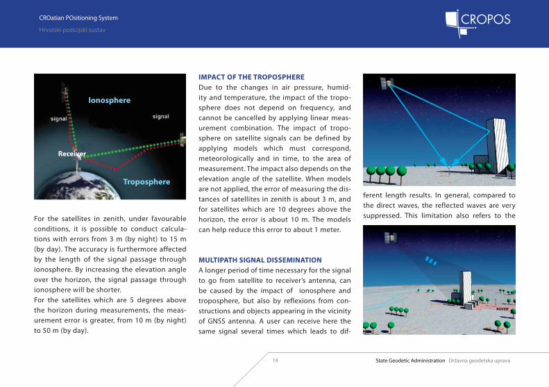
For the satellites in zenith, under favourable conditions, it is possible to conduct calcula-tions with errors from 3 m (by night) to 15 m (by day). The accuracy is furthermore affected by the length of the signal passage through ionosphere. By increasing the elevation angle over the horizon, the signal passage through ionosphere will be shorter. For the satellites which are 5 degrees above the horizon during measurements, the meas-urement error is greater, from 10 m (by night) to 50 m (by day).
IMPACT OF THE TROPOSPHEREDue to the changes in air pressure, humid-ity and temperature, the impact of the tropo-sphere does not depend on frequency, and cannot be cancelled by applying linear meas-urement combination. The impact of tropo-sphere on satellite signals can be defined by applying models which must correspond, meteorologically and in time, to the area of measurement. The impact also depends on the elevation angle of the satellite. When models are not applied, the error of measuring the dis-tances of satellites in zenith is about 3 m, and for satellites which are 10 degrees above the horizon, the error is about 10 m. The models can help reduce this error to about 1 meter.
MULTIPATH SIGNAL DISSEMINATIONA longer period of time necessary for the signal to go from satellite to receiver’s antenna, can be caused by the impact of ionosphere and troposphere, but also by reflexions from con-structions and objects appearing in the vicinity of GNSS antenna. A user can receive here the same signal several times which leads to dif-
ferent length results. In general, compared to the direct waves, the reflected waves are very suppressed. This limitation also refers to the
Ionosphere
Receiver
Troposphere

Državna geodetska uprava State Geodetic Administration
CROatian POsitioning System
Hrvatski pozicijski sustav
20
CROatian POsitioning System
Hrvatski pozicijski sustav
State Geodetic Administration Državna geodetska uprava
signals received under a small elevation angle. The resulting error can be from 1 m to several hundreds of meters. During the measurement data processing, such impact can be cancelled or reduced by applying appropriate algorthms, but with a longer time period for measurement. It is very important here to take this impact into consideration during RTK measurement be-cause the measurement time period is relatively short.
GEOMETRICALLY CONDITIONED ERROR IMPACT
It is important to emphasize that value 1 ensures the best possible satellite constellation, value 6 ensures a good one, whereas values over 10 present a satellite constellation where processing is no longer possible. Determining a position is based on spatial intersec-tion which can be obtained from the measured lengths. Since the measured lengths are burdened with errors, consequently the position determined on the basis of these lengths is burdened with errors. A graphical display of these mistakes looks like a rhomb and the possible positions of a measured point are within it. The size of a rhomb depends on the size of an error of the measured length and the
elevation angle of the satellite. Therefore, the posi-tion error is smallest when the elevation angle of the satellite above the user is 90 degrees.

Državna geodetska uprava State Geodetic Administration
CROatian POsitioning System
Hrvatski pozicijski sustav
CROatian POsitioning System
Hrvatski pozicijski sustav
State Geodetic Administration Državna geodetska uprava21
PARAMETERS OF ACCURACY
The accuracy of determining the position through the GNSS measurement method depends on two factors: 1. The accuracy of determining particular pseu-do-distance expressed through User Equivalent Range Error or through the attached standard deviation. 2. Geometric configuration of available satellites.
The quality of satellite geometry is assessed through the DOP (Dilution of Precision) param-eters. It is important to emphasize that value 1 ensures the best possible satellite constellation, value 6 ensures a good one, whereas values over 10 present a satellite constellation where process-ing is no longer possible.

Državna geodetska uprava State Geodetic Administration
CROatian POsitioning System
Hrvatski pozicijski sustav
22
CROatian POsitioning System
Hrvatski pozicijski sustav
State Geodetic Administration Državna geodetska uprava
RTCM
RTCM2.1
RTCM FORMATS
1 Differential GPS corrective data (pseudo-distances and speed, max. 12 satellites)2 Corrected pseudo-distances, in relation to the old orbit data (max. 12 satellites)3 Reference station coordinates (ECEF X, Y, Z) 6 Initial message, used as time record16 Specific message (max. 90 characters – ASCII-text)
9 GPS partial corrections (max. 3 satellites per message) 17 GPS ephemerides (1 satellite per message)18 RTK phase measurements, uncorrected 19 RTK pseudo-distances, uncorrected20 RTK phase measurements – corrective data21 RTK pseudo-distances – corrective data
The corrective data is sent to the users in standardized RTCM format. The RTCM format has been developed throughout many years, therefore today there are several formats in use, differing primarily in the scope of data (number of messages) that can be transferred to users. The following are the descriptions of particular RTCM formats, emphasizing the most important messages which are transmitted through them.

Državna geodetska uprava State Geodetic Administration
CROatian POsitioning System
Hrvatski pozicijski sustav
CROatian POsitioning System
Hrvatski pozicijski sustav
State Geodetic Administration Državna geodetska uprava23
14 GPS time, GPS week22 Additional parameters of reference station31 Differential GIONASS correction (otherwise type 1)37 GNSS System Time of set (seconds of merging)
1001 GPS L1 measurements1002 GPS L1 measurements (additional information 1)1003 GPS L1+L2 measurements1004 GPS L1+L2 measurements (additional information 1)1005 Reference station coordinates (ECEF XYZ)1006 Reference station coordinates (ECEF XYZ and additional information 2)1007 Antenna type
23 Antenna code (title, ID, antenna serial number)24 Antenna height and Antenna Reference Point (ARP) data
RTCM2.2
RTCM2.3
RTCM3.0
1008 Antenna type (additional information 3)1009 GLONASS L1 measurements1010 GLONASS L1 measurements (additional information 4)1011 GLONASS L1+L2 measurements1012 GLONASS L1+L2 measurements(additional information 4)1013 System parameters, list of transmitted messages
Državna geodetska uprava State Geodetic Administration
CROatian POsitioning System
Hrvatski pozicijski sustav
24
CROatian POsitioning System
Hrvatski pozicijski sustav
State Geodetic Administration Državna geodetska uprava
RTCM
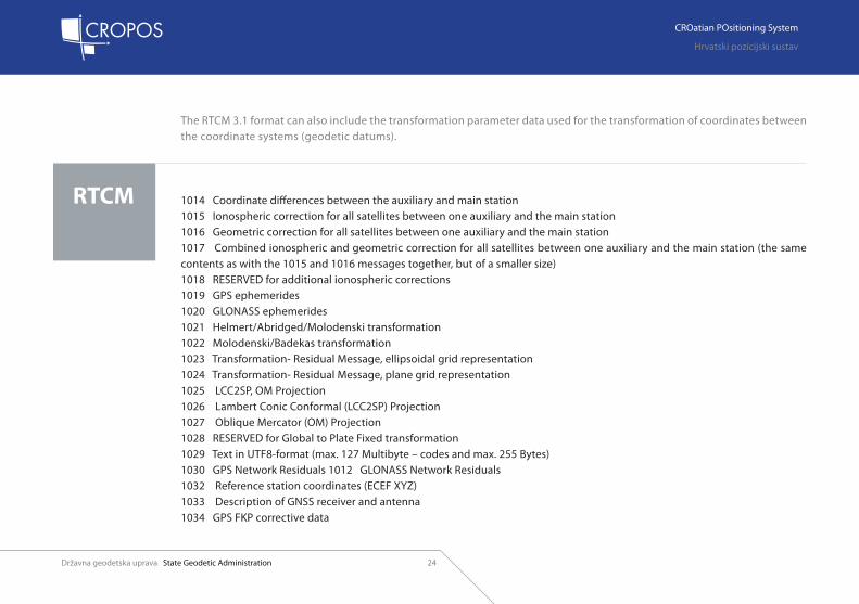
The RTCM 3.1 format can also include the transformation parameter data used for the transformation of coordinates between the coordinate systems (geodetic datums).
1014 Coordinate differences between the auxiliary and main station1015 Ionospheric correction for all satellites between one auxiliary and the main station1016 Geometric correction for all satellites between one auxiliary and the main station1017 Combined ionospheric and geometric correction for all satellites between one auxiliary and the main station (the same contents as with the 1015 and 1016 messages together, but of a smaller size)1018 RESERVED for additional ionospheric corrections 1019 GPS ephemerides1020 GLONASS ephemerides1021 Helmert/Abridged/Molodenski transformation1022 Molodenski/Badekas transformation1023 Transformation- Residual Message, ellipsoidal grid representation1024 Transformation- Residual Message, plane grid representation1025 LCC2SP, OM Projection1026 Lambert Conic Conformal (LCC2SP) Projection1027 Oblique Mercator (OM) Projection1028 RESERVED for Global to Plate Fixed transformation1029 Text in UTF8-format (max. 127 Multibyte – codes and max. 255 Bytes)1030 GPS Network Residuals 1012 GLONASS Network Residuals1032 Reference station coordinates (ECEF XYZ)1033 Description of GNSS receiver and antenna1034 GPS FKP corrective data

Državna geodetska uprava State Geodetic Administration
CROatian POsitioning System
Hrvatski pozicijski sustav
CROatian POsitioning System
Hrvatski pozicijski sustav
State Geodetic Administration Državna geodetska uprava25
The transfer of corrective data can be con-ducted in several ways, depending on the pos-sibilities and needs of users, in real-time or for additional measuement data processing
REAL TIME DATA TRANSFER
RadiowavesAt the beginning of real time data transfer implementa-tion, the method used for the transfer of corrective data was through the own temporary base station at different wave lengths (e.g. in Germany 70 cm, 2 m or 4 m). The advantage of this system was in the good re-gional applicability, reason-able costs and speed of data
transfer. The disadvantage of this system was in the insufficient range and dependence on the terrain configuration. In order to cover a larger territory, the corrective data was trans-ferred through a radio transmitter in the area of short, middle and long waves.
DATA TRANSFER METHODS
Satellite systemsFor the global transmission of corrective data, the so-called SBAS (Satellite Based Augmentation Sys-tem) services are used. Such services are the follow-ing: EGNOS (European Geostationary Navigation Overlay Service), MSAS (Multifunctional Satellite Augmentation System) and the planned GAGAN (GPS Aided Geo Augmented Navigation) or the commercial OmniSTAR, which send the corrective data through geostationary satellites. The correc-tive data for DGPS are mostly sent in RTCM formats. The available accuracy of non-commercial services is 1 to 3 m, and regarding the OmniSTAR commer-cial service, the accuracy is about 0.1 m. However, these services do not support the RTK GNSS meas-urement method.

Državna geodetska uprava State Geodetic Administration
CROatian POsitioning System
Hrvatski pozicijski sustav
26
CROatian POsitioning System
Hrvatski pozicijski sustav
State Geodetic Administration Državna geodetska uprava
Mobile phone systemsThe GSM (Global System for Mobile Commu-nications) defines a standard for mobile net-works which cover Europe and are available to users. The GSM standards represent the sec-ond digital generation of mobile networks. The range of digital transmission of data is from several hundreds of meters in cities up to 35 km in mutual line of sight of transmitters. The capacity of data transfer for the second gener-ation GSM standards is between 9,8 kbit/s and 220 kbit/s. Meanwhile, the third generation standards have occurred, enabling a transfer of large quantities of data in a short period of time. The first increase of tranfer capacities to 150 kbit/s - 200 kbit/s was enabled through the EDGE (Enhanced Data Rates for GSM Evolution) system. Further development of this stand-ard has been enabled by the UMTS (Universal Mobile Telecommunications System) with the data transfer speed of 384 kbit/s to 7,2 Mbit/s, as well as the further development of HSDPA (High Speed Downlink Packet Access) system which enables data transfer from 3,6 Mbit/s to 13,98 Mbit/s.This manner of data transfer requires the ex-
istance of permanent connection between the user and corrective data service provider. Fur-thermore, the so-called package-oriented data transfer methods have been developed, such
as GPRS (General Packet Radio Service). Re-garding these services, only the actual transfer or exchange of data is calculated, not the du-ration of the established connection between user and service provider.
InternetNTRIP (Networked Transport of RTCM via Inter-net Protocol) is a procedure developed in Bun-desamt für Kartographie und Geodäsie (BKG, Frankfurt am Main) with the objective to send corrective data through Internet. A user has access to the Internet through GPRS or UMTS technology. The NTRIP enables data transfer and data availability simultaneously to thou-sands of users. As a method of corrective data transfer, it has become a world standard.

Državna geodetska uprava State Geodetic Administration
CROatian POsitioning System
Hrvatski pozicijski sustav
CROatian POsitioning System
Hrvatski pozicijski sustav
State Geodetic Administration Državna geodetska uprava27
DATA TRANSFER FOR ADDITIONAL MEAS-UREMENT DATA PROCESSING
Near Real TimeWhen the corrective data is not available in real time, a user can conduct the measurement data processing immediately in the field, hav-ing completed the measurement process, and using the measurment data as well as the data that can be obtained from the server of refer-ence GNSS network. The data taken from the server is in RINEX (Receiver Independent Ex-change) or VRS RINEX (Virtual Reference Station RINEX) format. The advantage of this method is a fast verification already in the field, of the success of conducted measurements.
Post-processingIf there is no need to take over the data in the field, a user can take the necessary RINEX or VRS RINEX data through the Internet in the office, and conduct the measurement data processing.
Državna geodetska uprava State Geodetic Administration
CROatian POsitioning System
Hrvatski pozicijski sustav
28
CROatian POsitioning System
Hrvatski pozicijski sustav
State Geodetic Administration Državna geodetska uprava
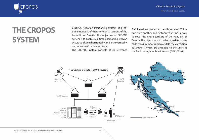
THE CROPOS SYSTEM
CROPOS (Croatian Positioning System) is a na-tional network of GNSS reference stations of the Republic of Croatia. The objective of CROPOS system is to enable real time positioning with an accuracy of 2 cm horizontally, and 4 cm vertically, on the entire Croatian territory. The CROPOS system consists of 30 reference
GNSS stations placed at the distance of 70 km one from another and distributed in such a way to cover the entire territory of the Republic of Croatia. The objective is to collect the data of sat-ellite measurements and calculate the correction parameters which are available to the users in the field through mobile internet (GPRS/GSM).

Državna geodetska uprava State Geodetic Administration
CROatian POsitioning System
Hrvatski pozicijski sustav
CROatian POsitioning System
Hrvatski pozicijski sustav
State Geodetic Administration Državna geodetska uprava29
THE CROPOS SERVICE
The users can access three CROPOS system serv-ices which are different in terms of the solution method, data transfer method, time of avail-ability, positioning accuracy and data format. The standard formats (RTCM, RINEX i VRS RINEX) are used for the transfer of corrective data and measurement data. The users can access correc-tive data in real time through mobile internet, whereas the data for post-processing is available through standard internet.
C
M
Y
CM
MY
CY
CMY
K
ENG_iznutra.ai 10/2/08 7:45:01 PM
C
M
Y
CM
MY
CY
CMY
K
ENG_iznutra.ai 10/2/08 7:45:01 PM

Državna geodetska uprava State Geodetic Administration
CROatian POsitioning System
Hrvatski pozicijski sustav
30
CROatian POsitioning System
Hrvatski pozicijski sustav
State Geodetic Administration Državna geodetska uprava
DSP In order to use the DSP service, the following conditions are required:
a) be a registered CROPOS userb) have a GNSS receiver which can read the RTCM 2.3 data format or its advanced versionc) establish a connection through mobile Internetd) receive signals from an adequate number of sat-ellites, at least 4, in order to calculate own position
When these conditions are met, the only thing you need to do is to connect yourselves to the CROPOS system and in that way you will receive the correction data. Only a few seconds later, your receiver will trans-fer from the navigation mode to the differential mode. This is the way in which submeter accu-racy is achieved.
1. Established connections:a) mobile internetb) CROPOS
2. A user obtains corrective data in RTCM 2.3 for-mat through mobile internet
Državna geodetska uprava State Geodetic Administration
CROatian POsitioning System
Hrvatski pozicijski sustav
CROatian POsitioning System
Hrvatski pozicijski sustav
State Geodetic Administration Državna geodetska uprava31
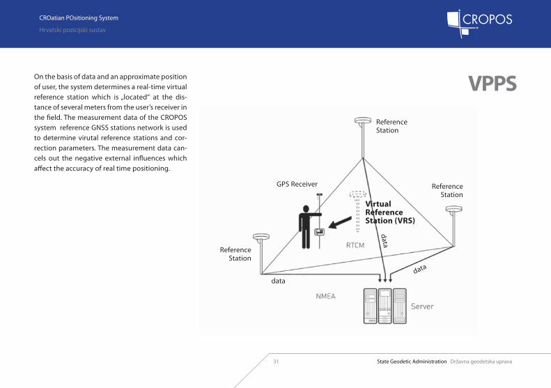
VPPSOn the basis of data and an approximate position of user, the system determines a real-time virtual reference station which is „located“ at the dis-tance of several meters from the user’s receiver in the field. The measurement data of the CROPOS system reference GNSS stations network is used to determine virutal reference stations and cor-rection parameters. The measurement data can-cels out the negative external influences which affect the accuracy of real time positioning.
Reference Station
Reference Station
Reference Station
Virtual Reference Station (VRS)
GPS Receiver
datadata
data

Državna geodetska uprava State Geodetic Administration
CROatian POsitioning System
Hrvatski pozicijski sustav
32
CROatian POsitioning System
Hrvatski pozicijski sustav
State Geodetic Administration Državna geodetska uprava
1. Established connections:a) mobile internetb) CROPOS
2. A user obtains corrective data in RTCM 2.3 for-mat through mobile internet

Državna geodetska uprava State Geodetic Administration
CROatian POsitioning System
Hrvatski pozicijski sustav
CROatian POsitioning System
Hrvatski pozicijski sustav
State Geodetic Administration Državna geodetska uprava33
GPPSPost-Processing: Individual reference station
If it is not possible to obtain the corrective data in real time for the high precision implementa-tion, it is possible to prepare the data after the measurements have been conducted. One possi-bility is to take over the measurement data of an individual reference station in RINEX (Continu-ously Operating Reference Station - CORS) for-mat. When applying this measurement method, the distance between a measured point and the CROPOS system reference station is very impor-tant. The required time of measurement depends on the distance between the user and the used reference station. The recommendation is to se-lect the closest reference station(s) to the meas-ured point. For point positioning, it is necessary to have the measurement time at a new point of at least 20 min plus 2 min for each kilometer. The achieved accuracy of obtained coordinates depends on the external influences and distance from the reference station. When the measurement time is 20 min and the length of base line is 20 min, the expected positioning accuracy is 20 mm.
With the extension of base line for one kilometer, the positioning accuracy is decreased by 2 mm per kilometer. The measurement data process-ing and coordinate calculation are conducted through the program for subsequent processing – post-processing. It is always possible to con-duct the control of determining the point coordi-nates by involving additional reference stations. The efficient control is achieved by repeating the measuring of a point after at least 2 hours. The CROPOS system RIHEX-shop enables the users to obtain the reference station measurement data.

Državna geodetska uprava State Geodetic Administration
CROatian POsitioning System
Hrvatski pozicijski sustav
34
CROatian POsitioning System
Hrvatski pozicijski sustav
State Geodetic Administration Državna geodetska uprava
After entering username and password, it is possible to access RINEX-shop and services of CROPOS GPPS.
Državna geodetska uprava State Geodetic Administration
CROatian POsitioning System
Hrvatski pozicijski sustav
CROatian POsitioning System
Hrvatski pozicijski sustav
State Geodetic Administration Državna geodetska uprava35
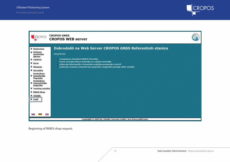
Beginning of RINEX-shop request.

Državna geodetska uprava State Geodetic Administration
CROatian POsitioning System
Hrvatski pozicijski sustav
36
CROatian POsitioning System
Hrvatski pozicijski sustav
State Geodetic Administration Državna geodetska uprava
Beginning of new order.

Državna geodetska uprava State Geodetic Administration
CROatian POsitioning System
Hrvatski pozicijski sustav
CROatian POsitioning System
Hrvatski pozicijski sustav
State Geodetic Administration Državna geodetska uprava37
Select a reference station (CORS).
Državna geodetska uprava State Geodetic Administration
CROatian POsitioning System
Hrvatski pozicijski sustav
38
CROatian POsitioning System
Hrvatski pozicijski sustav
State Geodetic Administration Državna geodetska uprava
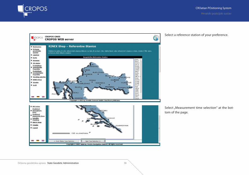
Select a reference station of your preference.
Select „Measurement time selection“ at the bot-tom of the page.

Državna geodetska uprava State Geodetic Administration
CROatian POsitioning System
Hrvatski pozicijski sustav
CROatian POsitioning System
Hrvatski pozicijski sustav
State Geodetic Administration Državna geodetska uprava39
Enter date, start time, duration and measurement interval for the selected reference station.Data on the date, start time and duration must correspond to the measurement time in the field.

Državna geodetska uprava State Geodetic Administration
CROatian POsitioning System
Hrvatski pozicijski sustav
40
CROatian POsitioning System
Hrvatski pozicijski sustav
State Geodetic Administration Državna geodetska uprava
1. Review of entered data.2. If you wish to change the data, it is possible to select different options. 3. Estimated prices of the requested data are also shown.4. If you accept the proposed order, select „Continue: Delivery options“.
4
231
Državna geodetska uprava State Geodetic Administration
CROatian POsitioning System
Hrvatski pozicijski sustav
CROatian POsitioning System
Hrvatski pozicijski sustav
State Geodetic Administration Državna geodetska uprava41
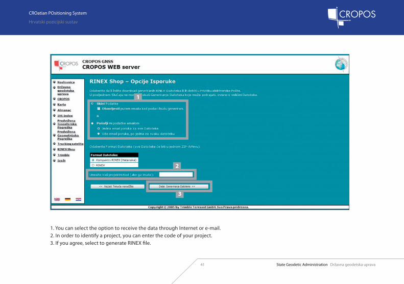
1. You can select the option to receive the data through Internet or e-mail.2. In order to identify a project, you can enter the code of your project.3. If you agree, select to generate RINEX file.
1
2
3

Državna geodetska uprava State Geodetic Administration
CROatian POsitioning System
Hrvatski pozicijski sustav
42
CROatian POsitioning System
Hrvatski pozicijski sustav
State Geodetic Administration Državna geodetska uprava
Preparing and generating measurement data.

Državna geodetska uprava State Geodetic Administration
CROatian POsitioning System
Hrvatski pozicijski sustav
CROatian POsitioning System
Hrvatski pozicijski sustav
State Geodetic Administration Državna geodetska uprava43
Having generated the data, the review of data and its estimated price are shown.Again you can select to receive the data through Internet or e-mail.
Državna geodetska uprava State Geodetic Administration
CROatian POsitioning System
Hrvatski pozicijski sustav
44
CROatian POsitioning System
Hrvatski pozicijski sustav
State Geodetic Administration Državna geodetska uprava
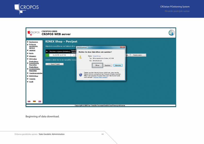
Beginning of data download.
Državna geodetska uprava State Geodetic Administration
CROatian POsitioning System
Hrvatski pozicijski sustav
CROatian POsitioning System
Hrvatski pozicijski sustav
State Geodetic Administration Državna geodetska uprava45
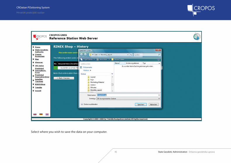
Select where you wish to save the data on your computer.

Državna geodetska uprava State Geodetic Administration
CROatian POsitioning System
Hrvatski pozicijski sustav
46
CROatian POsitioning System
Hrvatski pozicijski sustav
State Geodetic Administration Državna geodetska uprava
At the end, the program shows a review of your orders.

Državna geodetska uprava State Geodetic Administration
CROatian POsitioning System
Hrvatski pozicijski sustav
CROatian POsitioning System
Hrvatski pozicijski sustav
State Geodetic Administration Državna geodetska uprava47
GPPSPost-Processing: Virtual reference station
Together with the measurement data of indi-vidual reference stations, CROPOS also provides the users with the preparation of measurement data of Virtual Reference Stations (VRS) for post-
processing, the co-called VRS RINEX. Unlike for the implementation of individual reference station measurement data, the location of user in the net-work during measurement is not important.The virtual reference station data is generated on the basis of data from the entire network. The distance between an individual virtual ref-erence station and the new point should not exceed 5 km. In case a user moves in the areas of greater distances, it is necessary to generate more virtual reference stations. The measurement time of new points (blue within circles) depends on the used post-processing soft-ware. Minimal time period of measurement on a point is 15 min.

Državna geodetska uprava State Geodetic Administration
CROatian POsitioning System
Hrvatski pozicijski sustav
48
CROatian POsitioning System
Hrvatski pozicijski sustav
State Geodetic Administration Državna geodetska uprava
The coordinates of virtual reference station nec-essary for calculations are not entered, but taken from the file of VRS RINEX station (red outside circles). The control of measured points can be conducted through other virtual reference sta-tions. However, the best control is an independ-ent second measuring of the points and the re-peated preparation of virtual reference stations after at least 2 hours.
The prodedure of preparing the virtual reference station measurement data can be compared with the procedure of preparing the data of an indi-vidual reference station. After having accessed the system with a username and password and having selected the options of virtual reference station data, it is necessary to enter the coordi-nates of a point for which the virtual reference station measurement data wishes to be created.

Državna geodetska uprava State Geodetic Administration
CROatian POsitioning System
Hrvatski pozicijski sustav
CROatian POsitioning System
Hrvatski pozicijski sustav
State Geodetic Administration Državna geodetska uprava49
CORS or VRS?
Using the virtual reference stations significantly shorthens the necessary time of measurement. The
individual reference stations are used for determin-ing the higher rank points, with the appropriate duration of field measurements. When applying the GNSS measurement method for determining
permanent points of geodetic basis, the procedure of measurement and measurement data process-ing is defined by the Rules and Regulations on the manner of conducting basic geodetic works.
Having selected the op-tions of virtual reference station, its approximate coordinates need to be set.
It is possible to select the setting of virtual reference stations in geographic or ge-ocentric coordinate system.Then follows the same pro-cedure as for the individual reference station (see p. 38).

Državna geodetska uprava State Geodetic Administration
CROatian POsitioning System
Hrvatski pozicijski sustav
50
CROatian POsitioning System
Hrvatski pozicijski sustav
State Geodetic Administration Državna geodetska uprava
CROPOS QUALITY MANAGEMENT
The system operation is continuously supervised by the State Geodetic Administration. In order to obtain at any moment the information on the sys-tem operation quality in relation to the initializa-tion time as well as the accuracy and availability of the system, two independent permanent control stations have been established in Jastrebarsko and Nova Gradiška which simulate the work of users in the field.Every 10 seconds, the control stations connect to the CROPOS system and use the VPPS service for determining the position.On the CROPOS system web site (www.cropos.hr), the users can see the parameters of work and im-pact of control stations.

Državna geodetska uprava State Geodetic Administration
CROatian POsitioning System
Hrvatski pozicijski sustav
CROatian POsitioning System
Hrvatski pozicijski sustav
State Geodetic Administration Državna geodetska uprava5151
CROatian POsitioning System
Hrvatski pozicijski sustav
State Geodetic Administration Državna geodetska uprava
GPS antena - kalibrirana
GPS prijemnik s električnim napajanjem i uređajem za prijenos podatakaGPS receiver with electrical power supply and a data transfer device
GPS antenna - calibrated

Državna geodetska uprava State Geodetic Administration
CROatian POsitioning System
Hrvatski pozicijski sustav
52
CROatian POsitioning System
Hrvatski pozicijski sustav
State Geodetic Administration Državna geodetska uprava
Diagram shows RTK impact of control stations of every clock through 4 indicators:
GREEN = VERY GOOD, for at least 90% of meas-ured values: position error ≤ 2 cmand altitude error ≤ 3 cm i TIME TO FIX ≤ 1 min,
BRIGHT GREEN= VERY GOOD, for at least 90% of measured values: position error ≤3 cm and altitude error ≤ 5cm and TIME TO FIX ≤ 3 min,YELLOW=SATISFACTORY, for at least 67%of measured values: position error ≤3 cm and alti-tude error ≤ 5 cm and TIME TO FIX ≤ 3 min,
RED = INSUFFICIENT, for > 33% of measured val-ues: position error > 3 cm or altitude error > 5 cm or TIME TO FIX > 3 min
RTK impact of GPS receivers
Državna geodetska uprava State Geodetic Administration
CROatian POsitioning System
Hrvatski pozicijski sustav
CROatian POsitioning System
Hrvatski pozicijski sustav
State Geodetic Administration Državna geodetska uprava53
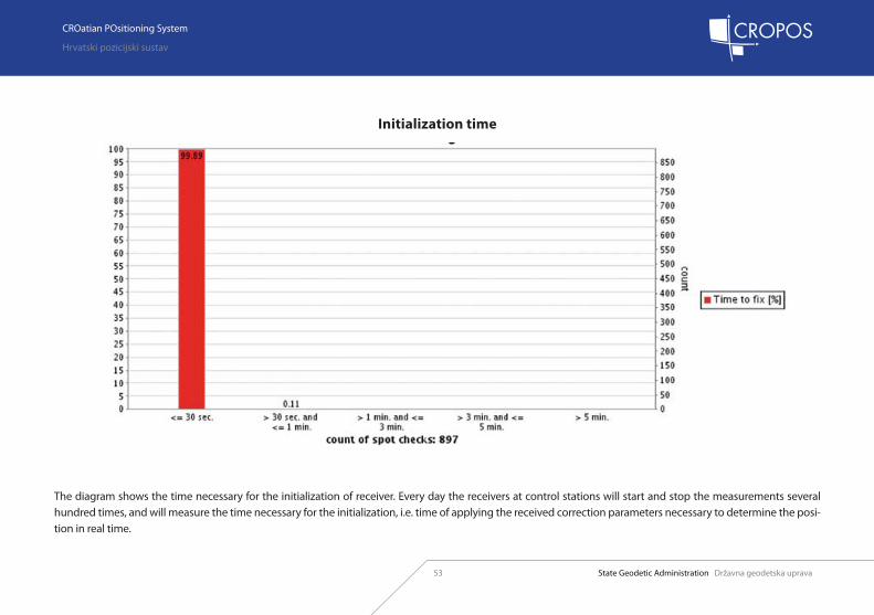
The diagram shows the time necessary for the initialization of receiver. Every day the receivers at control stations will start and stop the measurements several hundred times, and will measure the time necessary for the initialization, i.e. time of applying the received correction parameters necessary to determine the posi-tion in real time.
Initialization time

Državna geodetska uprava State Geodetic Administration
CROatian POsitioning System
Hrvatski pozicijski sustav
54
CROatian POsitioning System
Hrvatski pozicijski sustav
State Geodetic Administration Državna geodetska uprava
The diagram shows the measured point positioning accuracy allocation.
Accuracy of coordinates
Državna geodetska uprava State Geodetic Administration
CROatian POsitioning System
Hrvatski pozicijski sustav
CROatian POsitioning System
Hrvatski pozicijski sustav
State Geodetic Administration Državna geodetska uprava55
LIMITATIONS OF THE SYSTEMWhen applying the GNSS measurement method, it is necessary to ensure that the antenna for the satellite signal receipt has a free horizon. Also, it is necessary to take into consideration that the measurements are not conducted near con-structions that can cause multipath, i.e. a multiple receipt of the same signal. It is difficult to conduct the GNSS measurement method in cities or forests. In order to apply the RTK GNSS measurement method in real time, it is neces-sary to ensure the connection with the CROPOS sys-tem control centre for the receipt of corrective data, which, of course, depends on the extent to which the territory is covered by the GSM signal.
CROPOS LIMITATIONS AND
ADVANTAGES
WHY GNSS?The GNSS measurement method has numerous ad-vantages in relation to classical methods: 1. Line of sight between points is not necessary. 2. Can be applied at any time of day or night, in all weather conditions. 3. High accuracy results are obtained. 4. More work can be conducted in a shorter period of time, with less people.
WHY CROPOS?System advantages: 1. Own base is not necessary when applying RTK measurement method, which reduces the number of necessary GNSS devices. 2. Field measurements are shortened because it is not necessary to search for the reference points in order to set up the base device. 3. There is no risk that the base device might be stolen or damaged. 4. No limitations due to the range of radio-device for the transmission of correction parameters. 5. Much less time necessary for the rover initialization6. Measurement homogeneity on the territory of the entire state7. Increased accuracy and reliability of measurements.

Državna geodetska uprava State Geodetic Administration
CROatian POsitioning System
Hrvatski pozicijski sustav
56
CROatian POsitioning System
Hrvatski pozicijski sustav
State Geodetic Administration Državna geodetska uprava
FREQUENTLY ASKED QUESTIONS
1. Does the CROPOS system cover the entire territory of the Republic of Croatia?The CROPOS system services are available to users in the entire Republic of Croatia.
2. Where does a user register in order to access the CROPOS system services?The State Geodetic Administration has established the CROPOS system of reference stations and is re-sponsible for managing the control centre, super-vising the functioning of reference stations and assigning the user names and passwords which allow access to the system services. The user name and password which permit access to the CROPOS system services, are assigned to the user on the basis of a Request sent to the State Geodetic Ad-ministration. The request to use the CROPOS sys-tem services can be downloaded from the www.cropos.hr web site.
3. What kind of equipment is necessary to ac-cess the CROPOS system services?In order to receive the real time correction param-eters of the VPPS and DPS services, the user needs a GNSS receiver with a possibility to establish a GSM, GPRS or UMTS connection and also needs to
have a contract with a mobile operator that pro-vides one of the above-mentioned connections. Furthermore, the receiver needs to support the RTCM 2.3 or RTCM 3.1 formats of correction pa-rameters and also must have a possibility to trans-mit the NMEA GGA position message in case the user wants to use the VRS service. In order to use the GPPS service, the user needs to have access to the Internet so that he can download the meas-urement data in RINEX or VRS RINEX format.
4. What does the availability of CROPOS system services depend on?The availability of the CROPOS system services depends mostly on the availability and reliability of GSM/GPRS signals. Since the system is designed for transmitting the correction parameters via mobile Internet, it is important to have a reliable GSM/GPRS signal so that the user can connect to the CROPOS system. Also, it is necessary to be able to receive the satellite signal, as is the case for any other GNSS measurements.

Državna geodetska uprava State Geodetic Administration
CROatian POsitioning System
Hrvatski pozicijski sustav
CROatian POsitioning System
Hrvatski pozicijski sustav
State Geodetic Administration Državna geodetska uprava57
5. Where can I work with the CROPOS system?The CROPOS system reference stations are placed at the distance of 70 km one from another, and they are distributed in such a way to cover the entire territory of the Republic of Croatia. The CROPOS web site shows the network of reference stations and the area within a radius of 70 km that it covers. As it is shown, the CROPOS system is available in any point of the presented area. The availability of GSM/GPRS signal is the key compo-nent of the system, necessary for its functioning. Without a reliable GSM/GPRS signal, it is impossi-ble to connect to the system and use its resources in real time.
6. In what coordinate system are the coordi-nates of points, measured in CROPOS system, expressed?The coordinates of reference stations are calcu-lated in the ITRF2005 coordinate system, 2008.83 epoch of measurements (GPS week 1503), then they are transformed into ETRF00 (R05) system (ETRS89), therefore the coordinates of points measured by CROPOS system, are expressed in that system. ETRS89 (European Terrestrial Refer-ence System 1989) represents the official position
datum for the area of Europe. GRS80 (Geodetic Reference System 1980) is then used for the refer-ence ellipsoid.
7. What causes the differences in the coordi-nates of a measured point?The differences in the coordinates of a point that has been measured several times, occur most often due to the badly determined ambiguities in the system. This is caused by the intensified activitiy of ionosphere which is expressed by the I95 ionospheric index. The intensified activity of ionosphere influences mostly the short meas-urements, and not so much the longer measure-ments. The diagram of ionospheric index I95 for different time periods can be seen on the CROPOS system web site.
8. At what elevation do the GNSS measure-ments need to be conducted?The GNSS measurements are conducted at the elevation of 5° to 15°, depending on the type of works.
9. What if during the CROPOS system measur-ing, it is not possible to achieve initialization?
Before measuring, it would be useful to check on the CROPOS system web site the actual conditions of work (ionospheric index I95, anticipated iono-spheric error, anticipated geometric error, satel-lite monitoring, effect of control stations, etc.). In case the initialization cannot be achieved, to-gether with the above-mentioned, it is necessary to check the connection between the receiver and antenna, then the connection with the CROPOS system, all possible obstacles on the horizon, and also check the settings in the cotroller. If all these actions have no result, it is necessary to contact the customer support service.
10. Can several receivers use the same user name and password?With one user name and password, a user can at the same time have the service provided by using one GNSS device.
11. Is the subscription to CROPOS linked to a specific rover or a measuring device?No. The CROPOS subscription is not linked to a specific device. When the connection to the CRO-POS system is established through GPRS/UMTS mobile internet, the authorization is obtained by

Državna geodetska uprava State Geodetic Administration
CROatian POsitioning System
Hrvatski pozicijski sustav
58
CROatian POsitioning System
Hrvatski pozicijski sustav
State Geodetic Administration Državna geodetska uprava
assigning the user name and password, which enables measuring for several field teams with dif-ferent devices (but not simultaneously). When the connection to the CROPOS system is established through GSM modem, the authorization is ob-tained through the number of GSM modems.
12. Can there be any system breakdowns?The CROPOS system has been designed to be op-timally available and is supervised 24/7 in order to ensure a continuous work of the system with as few breakdowns as possible. The system will be temporarily unavailable during the maintenance works, and the users will be notified about it in ad-vance. Furthermore, it is important to have a good GSM/GPRS/UMTS signal in the area where meas-uring is conducted in order to be able to access the system services in real time.
13. What is the duration of licence?The licences for the use of CROPOS system serv-ices are provided in a form of annual subscription for the VPPS and DPS services, and also according to the time period of use (the billing control unit is 1 minute) for the VPPS and GPPS services.
14. Is it necessary to sign the contract with a specific mobile operator?No. The contract can be signed with any mobile operator because the CROPOS system supports GSM, GPRS and UMTS connection. Any mobile operator offering adequate coverage of the target territory and the stated telecommunication stand-ards, can be used to connect to the system.
15. How often does the rover in the field re-ceive the corrections from the system?The CROPOS system has been designed to send the corrections to the rover every second. How-ever, it is possible for the corrections to be late, depending on the availability of the signal of the mobile operator in the area where the works are conducted.
16. What types of corrections does CROPOS provide?CROPOS provides the following types of correc-tions: CROPOS VRS, single base RTK and DGNSS.

Državna geodetska uprava State Geodetic Administration
CROatian POsitioning System
Hrvatski pozicijski sustav
CROatian POsitioning System
Hrvatski pozicijski sustav
State Geodetic Administration Državna geodetska uprava59
CROPOS - Users’ Manual
Publisher:Republic of CroatiaState Geodetic Administration
For the publisher:Prof. Željko Bačić, Ph.D.
Manual prepared by:Marijan Marjanović, Ph.D.Hans-Peter Link, MSc
Editor: Marinko Bosiljevac, MSc
Design, layout and print:Status grupa d.o.o.
Circulation:1,000
ISBN: 978-953-293-100-6

Državna geodetska uprava State Geodetic Administration
CROatian POsitioning System
Hrvatski pozicijski sustav
60