Embed Size (px)
Citation preview

User Guide for NHD Maintenance/Revision Status TrackingUser Guide for NHD Maintenance/Revision Status Tracking
U.S. Department of the Interior U.S. Department of the Interior
U.S. Geological SurveyU.S. Geological Survey

Basic information:>Reason for system>Loads will not be accepted unless checked-out by submitting org>Eliminate conflicts>Reporting capability>Contact Information>History records

Status Tracking is accessed by selecting Maintenance/Revision Statuslocated on the navigation toolbar.

Sub Region Maintenance Lite I & II and Sub Basin Revision status graphicis displayed.

Subregion Maint-Lite I & II/Subbasin Revision status legend.Subregion Maint-Lite I & II/Subbasin Revision status legend.

Overlays can be toggled on and off by left clicking on the plus sign.

Subregions and Subbasins are toggled on by default. All layers can be toggled on and off as needed.

Zoom-In/Zoom-Out and PanNote: The wheel on your mouse can also be used to Zoom-In/Zoom Left click on the map and drag can also be used to Pan.

‘Zoom to HUC’ can be used to zoom to a specific Region,Subregion or Subbasin.

You may zoom to a specific state.

You may also zoom to a specific county.
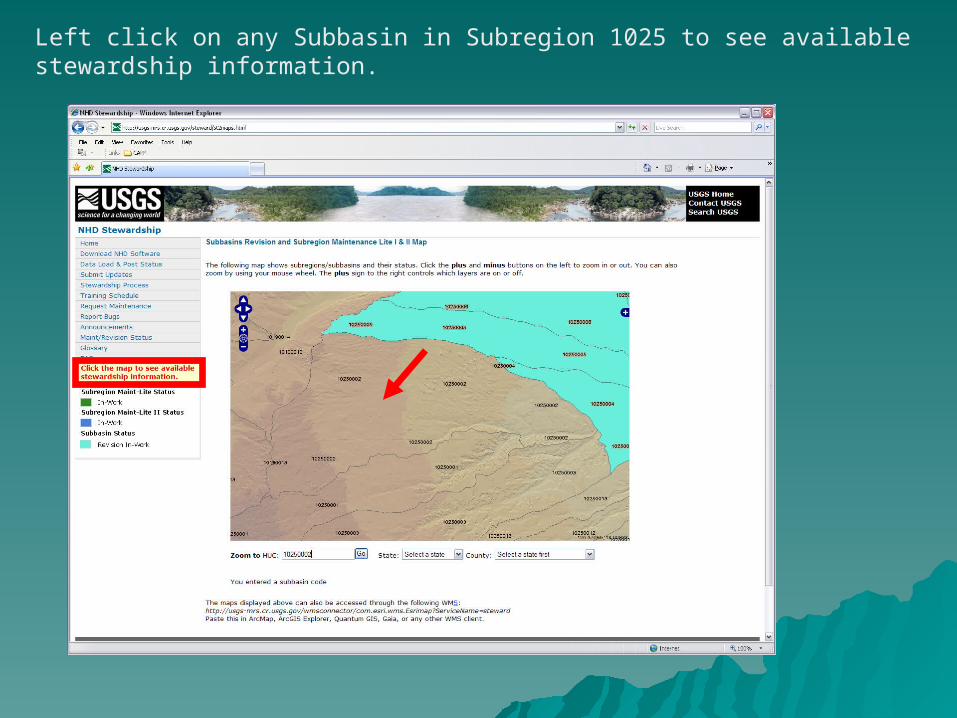
Left click on any Subbasin in Subregion 1025 to see availablestewardship information.

Stewardship information for Subbasin 10250002 is displayed.

Click on ‘Show history’ to get a description of what has occurred with this subbasin.

Click on ‘Show contact info’ to get a listing of pertinent contact information.

Click on ‘Generate report’ to get more specific information about the subbasin. It will first open a dialogue box to enter a User name and Password. Only authorized partners are allowed to generate reports. Contact your regional POC to obtain this information.

Fill in the necessary information to generate the report.
Right click and ‘Save Target as’ to save the Excel report to your hard drive.

The report generated will look something like this.

Checking out a Subasin:Left click on ‘Check-out this subbasin’.

Only authorized partners are allowed to Check-out datasets.Contact your regional POC for password.

Check-out form: All fields must be populated to checkout a subbasin(s). You must provide your contact information. WeWill be notifying you if your checked-out subbasin(s) is past due.We ask that you not keep a subbasin(s) checked-out for more than60 days.

You may check out any of the subbasins not grayed out. The grayed out information pertains to subbasins that are currently checked out. If you would like to check out the entire subregion,√Check the box next to ‘Select all subbasins available in this subregion.’
‘Your organization’ is controlled by a domain. If your organizationdoes not appear on the drop-down list, contact your regional POC.
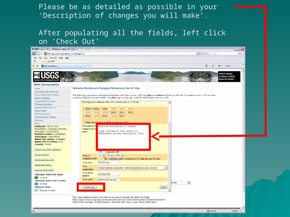
Please be as detailed as possible in your ‘Description of changes you will make’.
After populating all the fields, left click on ‘Check Out’and ‘Close’ form.

Subbasin 10250002 status has been updated to reflect Revision In-Work.

Note: If you are to be checking in a partial subbasin, you must notify your Regional POC and geodatabase load contact in either Denver or Rolla.
The first step would be to check out the sub basin that you intend to work on. After completing your edits, you may check in a portion of the subbasin by informing us that this is “part 1 of 4” and to submit the update into the load queue as “miscellaneous”. A miscellaneous load will not auto status the entire sub basin back to available. Parts “2 of 4” and “3 of 4” will also need to be submitted as miscellaneous and part “4 of 4” will be submitted as “revision”. The revision submittal will auto status the entire sub basin back to available. It is critical that this information be communicated with your regional POC and geodatabase load contact.
Loading a Partial Subbasin

Updated by Joel Skalet – 6-10-2009