Embed Size (px)
Citation preview

Page 1 of 25
USDA Plant Hardiness Zone Map User Guide Final USDA Agricultural Research Service
December 2011 Prepared for: Gary Rich Acting Deputy Chief Information Officer Office of the Chief Information Officer (OCIO) Agricultural Research Service (ARS) United States Department of Agriculture 5601 Sunnyside Avenue GWCC Room 3-2284 Beltsville, Maryland 20705 Prepared by: Esri 380 New York Street Redlands, California 92373-8100

Page 2 of 25
Table of Contents 1.0 USDA Plant Hardiness Zone Map Application.............................................................. 3
1.1 Introduction ................................................................................................................ 3 1.2 Supported Internet Browsers...................................................................................... 3
2.0 USDA Plant Hardiness Zone Map Application (JavaScript Enabled Internet Browser) ............................................................................................................................. 3
2.1 Introduction ................................................................................................................ 3 2.2 USDA PHZM Home Page ......................................................................................... 4
2.2.1 Plant Hardiness ZIP Code Finder .................................................................. 4 2.2.2 Static Map Images.......................................................................................... 5
2.3 USDA PHZM View Maps Page ................................................................................ 7 2.3.1 View Maps Wizard ........................................................................................ 7 2.3.2 Viewing the Map............................................................................................ 8
2.4 USDA PHZM About Pages ..................................................................................... 10 2.4.1 About Page Content ..................................................................................... 10
2.5 USDA PHZM Map & Data Downloads Page.......................................................... 11 2.5.1 Map Downloads ........................................................................................... 12 2.5.2 Geography (GIS) Downloads ...................................................................... 14 2.5.3 Multi-ZIP Code Finder ................................................................................ 15
2.6 USDA PHZM Interactive Map Page ....................................................................... 15 2.6.1 Access the Interactive Map Viewer ............................................................. 16 2.6.2 Interactive Map Viewer Tools ..................................................................... 16 2.6.3 Viewing Plant Hardiness Zone Data ............................................................ 17
2.7 USDA PHZM Help Page ......................................................................................... 18 2.7.1 How to Use This Website ............................................................................ 18 2.7.2 Contact USDA-ARS .................................................................................... 19
3.0 USDA Plant Hardiness Zone Map Application (JavaScript Disabled Internet Browser) ........................................................................................................................... 20
3.1 Introduction .............................................................................................................. 20 3.2 USDA PHZM Home Page ....................................................................................... 21
3.2.1 Plant Hardiness ZIP Code Finder ................................................................ 22 3.3 USDA PHZM View Maps Page .............................................................................. 22
3.3.1 View Maps ................................................................................................... 23 3.4 USDA PHZM Interactive Map Page ....................................................................... 25

Page 3 of 25
1.0 USDA Plant Hardiness Zone Map Application 1.1 Introduction This document provides instructions for using the USDA Plant Hardiness Zone Map (PHZM) Application. The PHZM User Guide is a reference tool to assist you with obtaining plant hardiness zone information for your area of interest. By the end of this guide, you will be able to obtain plant hardiness zone information from a plant hardiness ZIP Code Finder, from static map images and through an interactive GIS-based map. The PHZM User Guide is divided into two sections:
1. USDA Plant Hardiness Zone Map Application in a JavaScript enabled Internet Browser (Section 2.0)
2. USDA Plant Hardiness Zone Map Application in a JavaScript disabled Internet Browser (Section 3.0)
1.2 Supported Internet Browsers This application was designed and tested to function properly when using Microsoft Internet Explorer 8.0 and above and Mozilla Firefox 7.0 and above. If you are using an older version of these browsers or another browser and experience any problems with this application, we recommend you upgrade to the current versions. You may click on the links provided to download and upgrade to the current browsers. Microsoft Internet Explorer: http://www.microsoft.com/internetexplorer/ Mozilla Firefox: http://www.mozilla.org/firefox/ 2.0 USDA Plant Hardiness Zone Map Application
(JavaScript Enabled Internet Browser) 2.1 Introduction When you access the USDA Plant Hardiness Zone Map application in a JavaScript enabled Internet browser, you will access the home page which looks similar to the graphic below in section 2.2. If you have a JavaScript disabled Internet Browser, it will behave differently on some pages. To review those differences, click here

Page 4 of 25
2.2 USDA PHZM Home Page The USDA PHZM Home page consists of a Plant Hardiness ZIP Code Finder and static images of the plant hardiness zone map for the continental United States, Alaska, Hawaii, and Puerto Rico.
2.2.1 Plant Hardiness ZIP Code Finder The Plant Hardiness ZIP Code Finder allows you to retrieve a plant hardiness zone and temperature range for a ZIP Code using the following steps. First, make sure you are in the Home Page or select the Home tab on the toolbar to return to the Home page.
Step 1: Access the ZIP Code Finder Enter a five-digit ZIP Code in the Enter ZIP Code search field and click the Find button.
Step 2: Answer CAPTCHA Challenge A CAPTCHA Challenge will be displayed the first time you access the ZIP Code Finder from the home page. Enter the displayed CAPTCHA phrase in the Enter code field and click Validate. If you need audio assistance, click the Audio button to activate the CAPTCHA audio. Click the Reload button to refresh (change) the CAPTCHA image.

Page 5 of 25
Step 3: View Plant Hardiness Zone After answering the CAPTCHA question, the plant hardiness zone and temperature range will be displayed below the Enter ZIP Code search field.
2.2.2 Static Map Images There are two ways to access static map images of the plant hardiness zone map for the continental United States, Alaska, Hawaii, and Puerto Rico; each option is described below. To access, first make sure you are in the Home page or select the Home tab on the toolbar to return to the Home page.
Option 1 Click on a state in the continental United States, Alaska, Hawaii, or Puerto Rico on the plant hardiness zone map.

Page 6 of 25
A new pop-up window will display the selected plant hardiness zone map. To close the map, click the X button in the top right-hand corner of the pop-up window.
Option 2 Select a state (including Puerto Rico) from the View Your State Map drop-down menu.
Click on a state (including Puerto Rico) in the drop-down menu.
A new pop-up window will display the selected plant hardiness zone map. To close the map, click the X button in the top right-hand corner of the pop-up window.

Page 7 of 25
2.3 USDA PHZM View Maps Page The USDA PHZM View Maps page consists of a three-step wizard (i.e., selection process) to obtain state, regional or national plant hardiness zone maps in three different dots-per-inch (dpi) resolutions. 2.3.1 View Maps Wizard Access state, regional or national plant hardiness zone maps in three different resolutions using the following steps. To access the Wizard, make sure you are in the View Maps page or select the View Maps tab on the toolbar to return to the View Maps page. Step 1: Choose a geography – Select the State, Regional or National button.
After selection, a drop-down menu will appear. Select the state, region, or national map of interest. If State is selected, the drop-down menu will default to a list of state maps. If Regional is selected, the drop-down menu will default to a list of regional maps. If National is selected, the drop-down menu will default to a list of national maps.
Step 2: Select a resolution – After the geography selection, select the Standard, Medium, or High resolution button.

Page 8 of 25
Step 3: View a map – After the resolution selection, you have three options for accessing the map: Preview Map, Open Full Map, or Save Full Map. These options are further described in the next section. Select one of the options, and you should be able to access your map accordingly.
2.3.2 Viewing the Map This section describes the functionality associated with each of the available options for viewing the map defined in the View Maps Wizard (section 2.3.1).
2.3.2.1 Preview Map Button Click the Preview Map button. The map will appear within the PHZM window.

Page 9 of 25
2.3.2.2 Open Full Map Button Click the Open Full Map button. The map will appear in a new window. You can print this map using the browser default printing menu option or button.
2.3.2.3 Save Full Map Button Click the Save Full Map Button. Your default browser download window will appear, prompting you to open the file or save the file to your computer. Select "Save File" to save it locally.

Page 10 of 25
2.4 USDA PHZM About Pages The USDA PHZM About pages consist of detailed information regarding the following topics: Maps & Gardening, What's New, Map Making, Acknowledgments, and Copyright. 2.4.1 About Page Content There are two ways to access About page content; each option is described below. To access, make sure you are in the About page or select the About tab on the toolbar to return to the About page.
Option 1 – About Page Drop-Down Menu Place your cursor over the About tab on the toolbar. A drop-down menu will appear. Click the topic of interest, and the information will be displayed within the PHZM window.

Page 11 of 25
Option 2 – About Page Topics Click a page of interest in the About Topics box on the left side of the PHZM window. The page of interest will display in the PHZM window.
2.5 USDA PHZM Map & Data Downloads Page The USDA PHZM Map & Data Downloads Page consists of access to the following:
• Map Downloads: Downloadable maps for specialty purposes such as Print Quality Maps, Simplified Map Components, and Previous Edition of the Map.
• Geography (GIS) Downloads: Downloadable plant hardiness zone GIS data. • Multi-ZIP Code Finder: This selection provides an external link to Climate Source, Inc.,
which provides a multiple or "batch-mode" ZIP Code finder that may be purchased by the

Page 12 of 25
user. This application allows the user to match hundreds or thousands of 5-digit ZIP Codes with the appropriate USDA Plant Hardiness Zone.
Each of these is described in the sections below. 2.5.1 Map Downloads The Map Downloads page provides access to additional downloadable maps including Print Quality Maps, Simplified Map Components, and Previous Edition of the Map. Follow the steps below to access these resources. Step 1: Accessing the Map Downloads page There are two ways to access the Map Downloads page; each option is described below. First, make sure you are in the Map & Data Downloads page or select the Map & Data Downloads tab on the toolbar to return to the Map & Data Downloads page.
Option 1 – Map & Data Downloads Drop-Down Menu Place your cursor over the Map & Data Downloads tab on the toolbar. A drop-down menu will appear. Click Map Downloads. The Map Downloads page will appear in the PHZM window.
Option 2 – Map & Data Downloads Topics Click the Map Downloads link in the Map & Data Downloads Topics box on the left side of the PHZM.
Step 2: Selecting Desired Map Once you have opened the Map Downloads page, you can scroll down the page to select from a choice of Print Quality Maps, Simplified Map Components, and Previous Edition of the Map. Each is described below.
• Print Quality Maps are very large files and may take a long time to download. Most of the file formats are intended for graphic artists using specialized software. Very high-resolution posters of the PHZM can also be printed from these files. To open your choice, click the title.

Page 13 of 25
− Adobe Illustrator Files - Prompts the Internet Browser Save As window to download an .ai file.
− Adobe PDF - Opens an Adobe PDF in an Internet Browser window. − Graphic – Opens the graphic in an Internet Browser window. − Adobe Photoshop - Prompts the Internet Browser Save As window to download a
.ps file.
• Simplified Map Components are individual pieces of the map (title, legend, etc.) and several versions of the PHZM which can be utilized when displaying less detail is preferred. To open these files, scroll to the appropriate selection and click on the desired file. The file will open in a new Internet Browser window.
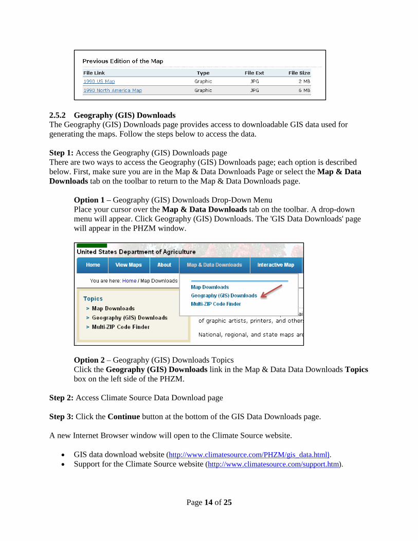
• Previous Edition of the Map gives you access to the previous edition of the USDA PHZM. To open either the United States version or the complete map (all of North America), click the title of the file. The corresponding Previous Edition PHZM map will open in a new Internet Browser window.
Page 14 of 25
2.5.2 Geography (GIS) Downloads The Geography (GIS) Downloads page provides access to downloadable GIS data used for generating the maps. Follow the steps below to access the data. Step 1: Access the Geography (GIS) Downloads page There are two ways to access the Geography (GIS) Downloads page; each option is described below. First, make sure you are in the Map & Data Downloads Page or select the Map & Data Downloads tab on the toolbar to return to the Map & Data Downloads page.
Option 1 – Geography (GIS) Downloads Drop-Down Menu Place your cursor over the Map & Data Downloads tab on the toolbar. A drop-down menu will appear. Click Geography (GIS) Downloads. The 'GIS Data Downloads' page will appear in the PHZM window.
Option 2 – Geography (GIS) Downloads Topics Click the Geography (GIS) Downloads link in the Map & Data Data Downloads Topics box on the left side of the PHZM.
Step 2: Access Climate Source Data Download page Step 3: Click the Continue button at the bottom of the GIS Data Downloads page. A new Internet Browser window will open to the Climate Source website.
• GIS data download website (http://www.climatesource.com/PHZM/gis_data.html). • Support for the Climate Source website (http://www.climatesource.com/support.htm).

Page 15 of 25
2.5.3 Multi-ZIP Code Finder This selection provides an external link to Climate Source, Inc., which provides a multiple or "batch-mode" ZIP Code finder that may be purchased. This application allows the user to match hundreds or thousands of 5-digit ZIP Codes with the appropriate USDA Plant Hardiness Zone. To access, follow the steps below. Step 1: Access the Multi-ZIP Code Finder page There are two ways to access the Multi-Zip Code Finder page; each option is described below. First, make sure you are in the Map & Data Downloads Page or select the Map & Data Downloads tab on the toolbar to return to the Map & Data Downloads page.
Option 1 – Multi-ZIP Code Finder Drop-Down Menu Place your cursor over the Map & Data Downloads tab on the toolbar. A drop-down menu will appear. Click Multi-ZIP Code Finder. The Multi-ZIP Code Finder page will appear in the PHZM window.
Option 2 – Multi-ZIP Code Finder Topics Click the Multi-ZIP Code Finder link in the Map & Data Downloads Topics box on the left side of the PHZM. The Multi-ZIP Code Finder page will appear in the PHZM window.
Step 2: Access the Multi-ZIP Code Finder Click the Climate Source Web Site button at the bottom of the Multi-ZIP Code Finder page. A new Internet Browser window will open to the Climate Source website.
• ZIP Code Finder website (http://www.climatesource.com/PHZM/zip.html). • Support for the Climate Source website (http://www.climatesource.com/support.htm).
2.6 USDA PHZM Interactive Map Page The USDA PHZM Interactive Map page is a dynamic viewer of plant hardiness zones for the continental United States, Alaska, Hawaii, and Puerto Rico.
Page 16 of 25
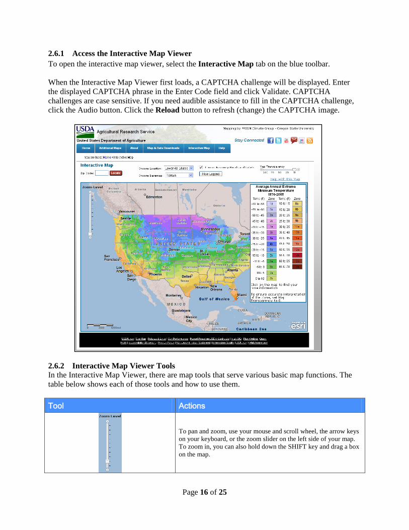
2.6.1 Access the Interactive Map Viewer To open the interactive map viewer, select the Interactive Map tab on the blue toolbar. When the Interactive Map Viewer first loads, a CAPTCHA challenge will be displayed. Enter the displayed CAPTCHA phrase in the Enter Code field and click Validate. CAPTCHA challenges are case sensitive. If you need audible assistance to fill in the CAPTCHA challenge, click the Audio button. Click the Reload button to refresh (change) the CAPTCHA image.
2.6.2 Interactive Map Viewer Tools In the Interactive Map Viewer, there are map tools that serve various basic map functions. The table below shows each of those tools and how to use them. Tool Actions
To pan and zoom, use your mouse and scroll wheel, the arrow keys on your keyboard, or the zoom slider on the left side of your map. To zoom in, you can also hold down the SHIFT key and drag a box on the map.

Page 17 of 25
Tool Actions
The interactive map is a multilayered map with the zone colors overlaying the selected basemap option (Terrain, Road Map, and Satellite Image). This feature adjusts the transparency of the zone colors, enabling the underlying attributes of the selected base map to be more or less apparent. Sliding the scale to the left makes the zone colors more transparent. Sliding the scale to the right makes the zone colors more opaque.
Check the 'Turn on Basemap Roads and Labels' box to display roads and labels on the displayed basemap. This option is available only for Terrain and Satellite Image basemap choices.
Click the Hide Legend box to display the map legend.
Choose Location displays Lower 48 States as the default location. You can change the location by clicking the Choose Location drop-down menu to switch between Lower 48 States, Alaska, Hawaii, and Puerto Rico.
Choose Basemap displays Terrain as the default basemap. You can change basemaps by clicking the Choose Basemap drop-down menu to switch between Terrain, Road Map, and Satellite Image.
Click Help with this map to get Interactive Map instructions and definitions of terms.
Enter a five-digit ZIP Code into the ZIP Code search field and click the Locate button. The location will be displayed on the map, and the map will zoom to that location.
2.6.3 Viewing Plant Hardiness Zone Data You can access plant hardiness zone data for any location on the Interactive Map by clicking once on the location of interest. When you click on that location, the data for that location is displayed in a pop-up box. The pop-up box displays the Plant Hardiness Zone, Average Temperature (Fahrenheit), Temperature Range (Fahrenheit) and the Longitude and Latitude. Note: After every 25 clicks, you will be presented with another CAPTCHA Challenge. This challenge is to prevent automated robots from unauthorized access to map information and overloading system access.

Page 18 of 25
2.7 USDA PHZM Help Page The USDA PHZM Help page consists of information on how to use this website and the ability to send an e-mail directly to the USDA. Both options are available from the "Help" tab. 2.7.1 How to Use This Website Step 1: Access the How to Use This Website page There are two ways to access the How to Use This Website page; each option is described below. First, make sure you are in the Help page or select the Help tab on the toolbar to return to the Help page.
Option 1 – Help Drop-Down Menu Place your cursor over the Help tab on the toolbar. A drop-down menu will appear. Click How to Use This Website. The How to Use This Website page will appear in the PHZM window.
Option 2 – Help Topics Click the How to Use This Website link in the Help Topics box on the left side of the PHZM.

Page 19 of 25
Step 2: Access PHZM HelpDoc You can read the PHZM HelpDoc on the How to Use This Website page, and you can also obtain a downloadable copy from this page. To download a copy of the PHZM HelpDoc in PDF or xxMB form, click the link in the dialog box at the top of the How to Use This Website page.
The PHZM HelpDoc will open in Adobe PDF in a new Internet Browser window. 2.7.2 Contact USDA-ARS Step 1: Access the Contact USDA-ARS Link This feature allows the user to send e-mail inquiries relating to the PHZM to the USDA–ARS (Agricultural Research Service). There are two ways to access the Contact USDA-ARS link; each option is described below. First, make sure you are in the Help page or select the Help tab on the toolbar to return to the Help page.
Option 1 – Help Drop-Down Menu Place your cursor over the Help tab on the toolbar. A drop-down menu will appear. Click Contact USDA-ARS. The USDA Agricultural Research Service (USDA-ARS) page will appear in the main window.
Option 2 – Help Topics Click the Contact USDA-ARS link in the Help Topics box on the left side of the PHZM window. The Contact USDA Agricultural Research Service (USDA-ARS) page will appear in the main window.
Step 2: Send an e-mail to the USDA Agricultural Research Service Once the Contact USDA Agricultural Research Service (USDA-ARS) page appears, click the [email protected] link at the top of the page.
Your default computer mail client will appear. For example, if you have Microsoft Outlook installed on your computer, the following will appear.

Page 20 of 25
If you do not have a default e-mail client on your computer, you can copy the e-mail address and paste it into a different e-mail client (e.g., Google Gmail, Yahoo). Step 3: Access the USDA Ask the Expert forum This link is used to send inquiries which are more general in nature and not related to the PHZM. To access the USDA Ask the Expert forum, click the Ask The Expert link that appears on the Contact USDA Agricultural Research Service (USDA-ARS) page.
A new Internet Browser window will appear with the USDA Ask an Expert website (http://www.usda.gov/wps/portal/usda/usdahome?navid=ASK_EXPERT2). 3.0 USDA Plant Hardiness Zone Map Application
(JavaScript Disabled Internet Browser) 3.1 Introduction When you access the USDA Plant Hardiness Zone Map application web in a JavaScript disabled Internet Browser, the website's home page will look similar to the graphic below. However, the PHZM website will perform differently in several sections in a JavaScript disabled Internet Browser as compared to the JavaScript enabled Internet Browser. If you have a JavaScript enabled Internet Browser, click here.

Page 21 of 25
The PHZM website in a JavaScript disabled Internet Browser will perform differently in several sections compared to the JavaScript enabled Internet Browser. Below are the main differences. 3.2 USDA PHZM Home Page The USDA PHZM Home Page includes a Plant Hardiness ZIP Code Finder.

Page 22 of 25
3.2.1 Plant Hardiness ZIP Code Finder The Plant Hardiness ZIP Code Finder allows you to search a plant hardiness zone and temperature range for a ZIP Code using the following steps. First, make sure you are in the Home Page or select the Home tab on the toolbar to return to the Home page. Step 1: Answer CAPTCHA Challenge Enter the displayed CAPTCHA phrase in the Enter Code field and click Validate. Click the Audio button to activate the CAPTCHA audio. Click the Reload button to refresh (change) the CAPTCHA image.
Step 2: Access the ZIP Code Finder Enter a five-digit ZIP Code in the Enter ZIP Code search field and click the Find button. The plant hardiness zone and temperature range will be displayed below the search field (the CAPTCHA challenge will disappear).
3.3 USDA PHZM View Maps Page

Page 23 of 25
The USDA PHZM View Maps Page consists of access to state, regional and national plant hardiness zone maps in three different resolutions.
3.3.1 View Maps The View Maps page allows you to access state, regional and national plant hardiness zone maps in three different resolutions (72, 150, and 300 dpi). First, make sure you are in the View Maps page or select the View Maps tab on the toolbar to return to the View Maps page. Step 1: Access Standard 72 dpi Resolution National Maps For standard resolution (72 dpi) national maps, click either US Zone Map or US Zone Map – without A and B zone divisions.
Step 2: Download Standard 72 dpi Resolution National Maps Your default browser download window will appear, prompting you to open the file or save the file to your computer. Select "Save File" to save it locally.

Page 24 of 25
Step 3: Access Standard 72 dpi Resolution Regional Maps For standard resolution (72 dpi) regional maps, click the U.S. by Region drop-down menu.
Step 4: Download Standard 72 dpi Resolution Regional Maps Select a region and click the Download button. Your default browser download window will appear and will allow you to save the file to your computer.
Step 5: Access Standard 72 dpi Resolution State Maps For standard resolution (72 dpi) state maps, click the States drop-down menu.
Step 6: Download Standard 72 dpi Resolution State Maps Select a state and click the Download button. Your default browser download window will appear and will allow you to save the file to your computer.
Step 7: Medium (150 dpi) and High (300 dpi) Resolution national, regional and state Maps

Page 25 of 25
To access medium resolution (150 dpi) and high resolution (300 dpi) national, regional and state maps, follow the above directions.
3.4 USDA PHZM Interactive Map Page The Interactive Map viewer is not available in the JavaScript disabled Internet Browser.