Embed Size (px)
Citation preview
US EPA RECORDS CENTER REG ON 5
11111 Oil 1111111111111
%ler' 81:44,0.
UgqITED STATES ENVIRONMENTAL PROTECTION AGENCY REGION 5 ca
77 WEST JACKSON BOULEVARD CHICAGO, IL 60604-3590 44. piR
495002
REPLY TO THE ATTENTION OF
MEMORANDUM
SUBJECT: ACTION MEMORANDUM: Request for a Time-Critical Removal Action and an Exemption from the $2 Million Statutory Limit at the Layer Park Site, Miami Township, Montgomery County, Ohio (Site ID # C5BC)
FROM: Stephen Wolfe, OSC Emergency Response Section 1
THRU: Jason H. El-Zein, Chief Emergency Response Branch 1
TO: Douglas Ballotti, Acting Director Superfund Division
I. PURPOSE
The purpose of this memorandum is to document the deteimination of an imminent and substantial threat to public health, welfare, and the environment posed by the presence of uncontrolled hazardous substances, and to request and document your approval to expend up to $3,124,184 to address the threat at this site. This memorandum also documents the grounds for an exemption from the $2 million statutory limit in order to conduct a time-critical removal action at the Layer Park Site (the Site) located in Miami Township, Montgomery County, Ohio.
The Ohio Environmental Protection Agency (OHIO EPA) has documented the presence of lead and arsenic contamination in the surface soils of a community park and lead contamination in one residential property through assessments performed in 2016 (AR #6). The U.S. Environmental Protection Agency confirmed the presence of lead in the community park during a separate sampling event performed on May 17, 2016 (AR #8).
Total lead values in the park and in one adjacent residential property were found up to 23,000 parts per million (ppm) and 24,000 ppm, respectively, exceeding the EPA criteria for unrestricted land use of 400 parts per million @pm). Total arsenic values in the park were found up to 210 ppm exceeding the EPA criteria for unrestricted land use of 68 ppm. The proposed time-critical removal action will mitigate the threat to public health, welfare, and the environment posed by the presence of lead and arsenic contamination in surface soils at the Site. The proposed removal action addresses surface soils in the park as well as contaminated soils in adjacent residential properties.
The proposed removal action will be conducted in accordance with Section 104(a)(1) of the Comprehensive Environmental Response, Compensation and Liability Act (CERCLA), 42
Recycled/Recyclable e Printed with Vegetable Oil Based Inks on 100% Recycled Paper (100% Post-Consumer)

U.S.C. 9604(a)(1), and 40 C.F.R. § 300.415 of the National Oil and Hazardous Substances Pollution Contingency Plan (NCP), to abate or eliminate the immediate threat posed to public health and the environment by the presence of the hazardous substances, pollutants or contaminants
The uncontrolled conditions of the hazardous substances, pollutants or contaminants present at the Site require that this action be classified as a time-critical removal action. The removal is expected to require approximately 120 working days to complete.
There are no nationally significant or precedent setting issues associated with the Layer Park Site and the Site is not on the National Priorities List (NPL).
II. SITE CONDITIONS AND BACKGROUND
CERCLIS ID: 0HN000506381 RCRA ID: State ID: Category: Time-Critical Removal Action
A. Site Description
The Site encompasses a 7.5-acre public park and adjacent residential properties. The western half of the park is open and contains a baseball diamond and basketball courts. The eastern half of the park is wooded and contains a shelter, outdoor children's playsets and picnic tables. The entire park property is fenced and has good vegetative cover.
According to the Ohio Environmental Protection Agency (Ohio EPA), a skeet shooting range operated on the Site during the 1930s, 1940s, and the 1950s. Aerial photos from Ohio Department of Transportation (ODOT) show two skeet shooting stations to the south of the Site boundary on The Miami Valley Hunt and Polo Club (MVHPC). Shooting occurred from the MVHPC stations to the north (AR #6). An unknown quantity of lead was deposited on the surface of the soil from the past skeet shooting activities (AR #6).
In January, 2016, Miami Township voluntarily closed the park after receiving information from Ohio EPA that the park was potentially contaminated with lead. Miami Township erected temporary fencing and locked all access gates to the park. In addition, signage was placed at the entrance warning residences of lead contamination.
1. Removal Site Evaluation
Ohio EPA's Site Investigation Field Unit (SIFU) collected soil samples from Layer Park in 2013 as part of a voluntary action program background metals study for Montgomery County. Ohio EPA's SIFU identified that the surficial soils contained high levels of lead contamination over the levels for unrestricted residential use and recommended the Site for a state-lead site assessment (AR #6).
2
Ohio EPA's Division of Environmental Response and Revitalization (DERR) returned to the Site in February 2016, and conducted soil screening in the Layer Park "kick up zone" of 0-2 inches and identified lead contamination from 13 to 1,555 ppm. In March 2016, DERR returned to the Site and collected Layer Park samples from varying depths (up to two feet below ground surface (bgs)) across the entire park using a 75 foot grid. DERR used an X-Ray Fluorescence instrument to measure lead and arsenic levels and the results ranged from 7 to 5,274 ppm (lead) and 5 to 17 ppm (arsenic) in the park. A subset of these samples were sent in for laboratory confirmation and results ranged from 43 to 23,200 ppm (lead) and 6.2 to 210 ppm (arsenic) (AR #s 6&7).
In April 2016, DERR collected soil samples from the adjacent residential properties and identified 1 property where the lead results were above residential criteria (laboratory sample results ranged from 0.3 to 24,000 ppm (lead) and 1 to 57 ppm (arsenic)). Ohio EPA did not receive permission from 5 adjacent residential property owners to collect soil samples (AR #1).
Ohio EPA's analytical results indicated that most of the eastern half and a small portion in the southwest corner of Layer Park was contaminated with lead with one area also exhibiting high arsenic concentrations. In May 2016, EPA collected soil samples to further delineate the contaminated area and detennined that approximately 2.5 acres of the park was contaminated with lead. In addition, EPA collected soil samples from the property (private club) bordering the park to the east and southeast. Sample results from the club's property did not indicate lead contamination above actionable levels.
2. Physical location
The Site is located at 4999 Cordell Drive, Miami Township, Montgomery County, Ohio 45439. The geographical coordinates for the Site are 39.679672 degrees North latitude and 84.208775 degrees West longitude. The Site is located in a residential area and is surrounded by residential properties to the north, west, and southwest. To the east and southeast are wooded lots and a private club.
3. Site characteristics
The Site is comprised of an approximate 7.5-acre, community park and adjacent residential properties located in Miami Township, Ohio. Currently there is one impacted residential property. However, neither Ohio EPA nor EPA has been granted access for sampling purposes to 5 additional residential properties that border the park and which might also be contaminated.
The western half of the park is open and contains a baseball diamond and basketball courts. The eastern half of the park is wooded and contains a shelter, outdoor children's playsets and picnic tables. The entire park property is currently closed, fenced with locks to prevent public access and has good vegetative cover.
4. Release or threatened release into the environment of a hazardous substance, or pollutant or contaminant
Ohio EPA and EPA have documented the presence of high levels of lead and arsenic contamination in surficial soils at one residential property and a 7.5-acre community park.
3
Lead and arsenic are hazardous substances as defined by Section 101(14) of the Comprehensive Environmental Response, Compensation, and Liability Act (CERCLA).
The Agency for Toxic Substances and Disease Registry (ATSDR) ToxFAQ indicates that breathing high levels of inorganic arsenic can cause sore throat or irritated lungs. Ingesting very high levels of arsenic can result in death. Exposure to lower levels can cause nausea and vomiting, decreased production of red and white blood cells, abnoimal heart rhythm, damage to blood vessels, and a sensation of "pins and needles" in hands and feet. Several studies have shown that ingestion of inorganic arsenic can increase the risk of skin cancer and cancer in the liver, bladder, and lungs. Inhalation of inorganic arsenic can cause increased risk of lung cancer. The Department of Health and Human Services and the EPA have determined that inorganic arsenic is a known human carcinogen (AR #3).
The ATSDR ToxFAQ indicates that lead can affect almost every organ and system in your body. The main target for lead toxicity is the nervous system, both in adults and children. Long-term exposure of adults can result in decreased performance in some tests that measure functions of the nervous system. It may also cause weakness in fingers, wrists, or ankles. Lead exposure also causes small increases in blood pressure, particularly in middle-aged and older people, and can cause anemia. Exposure to high lead levels can severely damage the brain and kidneys in adults or children and ultimately cause death. In pregnant women exposure to high levels of lead may cause miscarriage. High level exposure in men can damage the organs responsible for sperm production (AR #2).
Children are more vulnerable to lead poisoning than adults. A child who swallows large amounts of lead may develop may develop blood anemia, severe stomachache, muscle weakness, and brain damage. If a child swallows smaller amounts of lead, much less severe effects on blood and brain function may occur. Even at much lower levels of exposure, lead can affect a child's mental and physical growth (AR #2).
Exposure to lead is more dangerous to young and unborn children. Unborn children can be exposed to lead through their mothers. Harniful effects include premature births, smaller babies, decreased mental ability in the infant, learning difficulties, and reduced growth in young children. These effects are more common if the mother of or baby was exposed to high levels of lead. Some of these effects may persist beyond childhood (AR #2).
5. NPL status
The Site is currently not on the National Priorities List (NPL).
6. Maps, pictures and other graphic representations
Figure 1 -3 are graphical representations of Ohio EPA's site assessment of Layer Park conducted in February 2016. Figure 4 is a graphical representation of Ohio EPA's site assessment of residential properties surrounding Layer Park conducted in April 2016.
4

Figures 5 and 6 are graphical representations of EPA's site assessment of Layer Park and the Miami Valley Hunt and Polo Club Inc (MVHPC) conducted in May 2016.
7. Environmental Justice Analysis
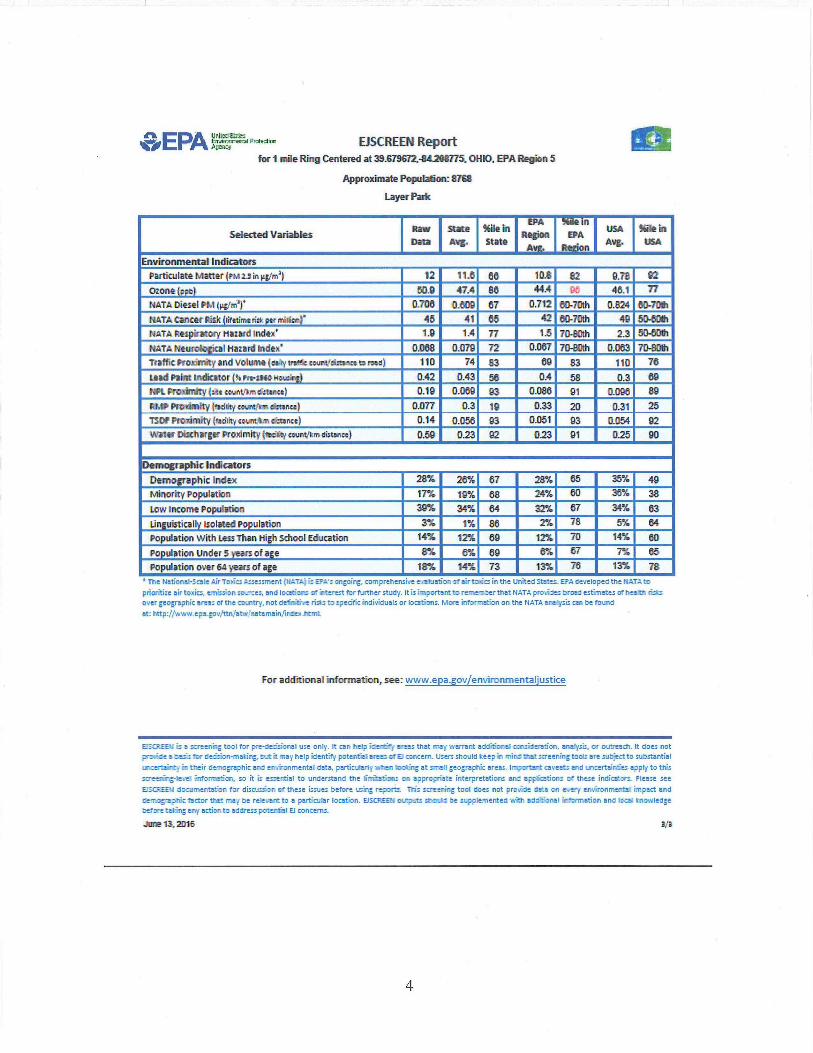
An Environmental Justice (EJ) analysis for the Site is contained in Attachment 1. Screening of the surrounding area used Region 5's EJ Screen Tool. Region 5 has reviewed environmental and demographic data for the area surrounding the Site and determined there is a low potential for EJ concerns at this location.
B. Other Actions to Date
1. Previous actions
This Action Memorandum documents previous investigatory actions by the Ohio EPA and EPA in the Background Section.
2. Current actions
Ohio EPA requested assistance from the EPA Region 5 Superfund Division in conducting a potential time-critical removal action at the Site.
C. State and Local Authorities' Roles
1. State and local actions to date
Ohio EPA performed a site assessment across the entire park and determined that approximately half the park was impacted. In addition, Ohio EPA performed site assessments of the residential properties that bordered the park and identified that one property is contaminated with lead (AR #s 1,6,&7).
Miami Township and Montgomery County closed the park, installed temporary fencing, and locked all gates which have access to the park. The park has been closed since January 2016.
2. Potential for continued State/local response
Ohio EPA has indicated that it does not have the resources to address the contaminated Site. In April 2016, Ohio EPA requested that EPA perform a removal action at the Site (AR #6).
III. THREATS TO PUBLIC HEALTH OR THE ENVIRONMENT, AND STATUTORYAND REGULATORY AUTHORITIES
The conditions at the Layer Park Site present a substantial threat to the public health or welfare, and the environment, and meet the criteria for a time-critical removal action as provided for in the NCP, 40 C.F.R. § 300.415(b)(2). These criteria include, but are not limited to, the following:
5
Actual or potential exposure to nearby human populations, animals, or the food chain from hazardous substances or pollutants or contaminants;
EPA and Ohio EPA have documented lead and arsenic contamination in surficial soils which exceed the EPA residential unrestricted land use criteria of 400 ppm for lead and 68 ppm for arsenic. Lead contamination has been documented at up to 23,200 ppm in the park and 24,000 ppm at one residence. Arsenic contamination has been documented up to 210 ppm in the park. Most of the lead and arsenic contamination is located in the top 12 inches of soil, with one area exhibiting high lead concentrations up to two feet deep.
Layer Park is a public park located in a residential area. Residential properties bordering the park all have private access to the park through gated back yards. Children's play areas (e.g., swing sets) are located in the portion of the park with contaminated soil.
Lead and arsenic are hazardous substances as defined by Section 101(14) of the Comprehensive Environmental Response, Compensation, and Liability Act (CERCLA).
High levels of hazardous substances or pollutants or contaminants in soils largely at or near the surface that may migrate;
Analytical results from site assessments conducted by Ohio EPA and EPA document the presence of high levels of hazardous substances in soils at or near the surface. Lead and arsenic were detected in multiple samples exceeding EPA RAL criteria for lead (400 ppm) and arsenic (68 ppm). In two samples, lead from the park exceeded the regulatory limit of 5 milligrams per liter (mg/1) for TCLP, indicating the potential for lead to leach from Site soils. Lead has been detected in samples at an adjacent residential property exceeding EPA Removal Action Levels criteria. The close proximity of residential areas adjacent to the Site greatly increases the likelihood of exposure to human populations, animals, and the food chain Exposure pathways include direct contact and ingestion associated with uncontrolled hazardous substances at the Site (AR #s 6&8).
Weather conditions that may cause hazardous substances or pollutants or contaminants to migrate or be released;
Although the Site is covered by vegetation, long periods of drought or hot weather can cause the Site's vegetation to dry out, leaving the soils bare and susceptible to migration due to heavy wind and rain.
The availability of other appropriate Federal or state response mechanisms to respond to the release;
In April 2016, Ohio EPA requested EPA's assistance in mitigating the potential threats at the Site (AR #6). Ohio EPA has indicated it does not have the resources to perfonn a cleanup of the Site.
IV. ENDANGERMENT DETERMINATION

Given the Site conditions, the nature of the known and suspected hazardous substances, pollutants or contaminants on Site, and the potential exposure pathways described in Sections II and III above, actual or threatened releases of hazardous substances, pollutants or contaminants from this Site, if not addressed by implementing the response actions selected in this Memorandum, may present an imminent and substantial endangerment to public health, welfare, or the environment.
V. EXEMPTION FROM STATUTORY LIMITS
Section 104(c) of CERCLA as amended by SARA, limits a Federal emergency response to $2 million unless three criteria are met. The quantities and levels of hazardous substances at the Layer Park Site warrant the $2 million exemption based on the following factors:
A) There is an immediate risk to public health or welfare or the environment;
The assessments conducted in 2016 identified high concentrations of lead and arsenic, as well as soils that were characteristically hazardous for lead at and near the surface. The concentrations exceeded Ohio residential direct contact standards for lead and arsenic. The presence of these high concentrations of heavy metals poses an immediate and continued risk to human health, welfare and the environment.
B) Continued response actions are immediately required to prevent, limit, or mitigate an emergency;
Response actions are required in order to mitigate the high concentrations of metals in surface soils and the presence of leachable concentrations of lead in surface soils at the Site. The close proximity of residential areas to the Site and the continued presence of total metals and leachable metals in surface soils present and imminent threat to public health, welfare, and the environment via direct contact exposures or potential migration off-site into the residential area.
C) Assistance will not otherwise be provided on a timely basis
When the Site was referred to EPA, Ohio EPA stated that it did not have the ability or sufficient funding to undertake the cleanup that is necessary. Local authorities are also unable to take action.
VI. PROPOSED ACTIONS AND ESTIMATED COSTS
A. Proposed Actions Taken
1. Action description
Removal activities on Site will include:
a) Developing and implementing a Site Health and Safety Plan and Site Work Plan;
7
b) Removal of trees in the contaminated areas (park and residential lot(s));
c) Sampling of residential properties if access is obtained;
d) Removal and disposal of contaminated soil (park and residential lot(s));
e) Restoration of park and private property where Removal Work occurred;
f) Taking any necessary response action to address any release or threatened release of a hazardous substance, pollutant or contaminant that EPA determines may pose an imminent and substantial endangerment to the public health or the environment.
Post Removal Site Controls - The removal action will be conducted in a manner not inconsistent with the NCP. The OSC has initiated planning for provision of post-removal Site control consistent with Section 300.415(1) of the NCP. Elimination of all threats presented by hazardous substances or pollutants or contaminants in the site soils is however, expected to minimize the need for post-removal Site control.
Off-Site Rule - All hazardous substances, pollutants or contaminants removed off-Site pursuant to this removal action for treatment, storage, and disposal shall be treated, stored, or disposed of at a facility in compliance, as EPA determines, with the EPA Off-Site Rule, 40 C.F.R. § 300.440.
2. Contribution to remedial performance:
The proposed action will not impede future actions, based on available information. The Site is currently not on the NPL.
3. Engineering Evaluation/Cost Analysis (EE/CA)
Not Applicable
4. Applicable or Relevant and Appropriate Requirements (ARARs)
All applicable, relevant, and appropriate requirements (ARARs) of Federal and state law will be complied with to the extent practicable considering the exigencies of the circumstances.
Federal RCRA Subtitle C SDWA MCLs TSCA
State
On July 28, 2016, EPA asked Mr. Scott Glum of Ohio EPA via electronic mail to identify any State of Ohio ARARs (AR #4). Ohio EPA identified ARARs via electronic mail dated July 29,
8

2016. ARARs identified include elements found in the Ohio Administrative Code Chapters 1501 and 3745 as well as the Ohio Revised Code Chapter's 1518, 1531, 3734, and 5301 (AR #5).
5. Project Schedule
The removal activities are expected to take 120 onsite working days to complete.
6. Disproportionate Funding
The response actions described in this memorandum directly address the actual or threatened release at the Site of hazardous substances, pollutants or contaminants, which may pose an imminent and substantial endangerment to public health, welfare, or the environment. EPA does not believe that these response actions will impose a disproportionate burden on the affected property.
B. Estimated Costs
The detailed cleanup contractor cost is presented in Attachment 2 and the Independent Government Cost Estimate is presented in Attachment 3. Estimated project costs are summarized below:
REMOVAL ACTION PROJECT CEILING ESTIMATE Extramural Costs: Regional Removal Allowance Costs:
Total Cleanup Contractor Costs $ 2,459,904 (This cost category includes estimates for ERRS, subcontractors, Notices to Proceed, and Interagency Agreements with Other Federal Agencies. Includes a 20% contingency)
Other Extramural Costs Not Funded from the Regional Allowance: Total START, including multiplier costs Total Decontamination, Analytical & Tech. Services (DATS) $ 143,280 Total CLP 0
0 Subtotal
$ 143,280 Subtotal Extramural Costs
$ 2,603,184 Extramural Costs Contingency (20% of Subtotal, Extramural Costs rounded to nearest thousand) $ 521,000
TOTAL REMOVAL ACTION PROJECT CEILING $3,124,184
9

VII. EXPECTED CHANGE IN THE SITUATION SHOULD ACTION BE DELAYED OR NOT TAKEN
Given the Site conditions, the nature and location of the hazardous substances documented on Site, and the potential exposure pathways to nearby populations described in this Action Memorandum, if not addressed by implementing the response actions selected in this Action Memorandum, may present an imminent and substantial endangerment to public health, welfare, or the environment.
VIII. OUTSTANDING POLICY ISSUES
None
IX. ENFORCEMENT
EPA completed its search for potentially responsible parties (PRPs) and determined that there are no viable PRPs. EPA sent a General Notice Letter to the MVHPC (likely origination of shooting debris); however, the President of the Club has indicated that there are no funds to address the park and that the club is considering filing for bankruptcy. For administrative purposes, information concerning the enforcement strategy for this Site is contained in the Confidential Enforcement Addendum.
The total EPA costs for this removal action based on full-cost accounting practices that will be eligible for cost recovery are estimated to be $5,687,316.1
($3,124,184+ $85,000) + (77.22% x $3,209,184) = $5,687,316
X. RECOMMENDATION
This decision document represents the determination that an imminent and substantial endangenlient may exist and the selected removal action for the Layer Park Site, located in Miami Township, Montgomery County, Ohio. It was developed in accordance with CERCLA, as amended, and is not inconsistent with the NCP. This decision is based upon the Administrative Record for the Site. Conditions at the Site meet the NCP Section 300.415(b)(2) criteria for a removal action and I recommend your approval of the proposed removal action.
The total removal action project ceiling if approved will be $3,124,184. Of this, an estimated $2,980,904 may be used for cleanup contractor costs. You may indicate your decision by signing below.
Direct Costs include direct extramural costs and direct intramural costs. Indirect costs are calculated based on an estimated indirect cost rate expressed as a percentage of site-specific direct costs, consistent with the full cost accounting methodology effective October 2, 2000. These estimates do not include pre-judgment interest, do not take into account other enforcement costs, including Department of Justice costs, and may be adjusted during the course of a removal action. The estimates are for illustrative purposes only and their use is not intended to create any rights for responsible parties. Neither the lack of a total cost estimate nor deviation of actual total costs from this estimate will affect the United States' right to cost recovery.
10
APPROVE
D ugla otti, Acting Director Superfund Division
DISAPPROVE DATE: Douglas Ballotti, Acting Director Superfund Division
Enforcement Addendum
Figures
1. Ohio EPA Layer Park sample results (0-6 inches) 2. Ohio EPA Layer Park sample results (6 -12 inches) 3. Ohio EPA Layer Park sample results (12-18 inches) 4. Ohio EPA Layer Park residential sample results 5. EPA Layer Park sample results 6. EPA MVHPC sample results
Attachments
1. EJ Analysis 2. Detailed Cleanup Contractor and START Estimate 3. Independent Government Cost Estimate 4. Administrative Record Index
cc: B. Schlieger, U.S. EPA HQ (email: Brian Schlieger/DC/USEPAJUS) L. Nelson, U.S. Department of Interior, w/o Enf. Addendum (email: [email protected]) Craig Butler, Director, Ohio EPA, w/o Enf. Addendum (email. [email protected]) Mike DeWine, Ohio Attorney General, w/o Enf. Addendum (email: [email protected])

BCC PAGE HAS BEEN REDACTED
NOT RELEVANT TO SELECTION
OF REMOVAL ACTION
ENFORCEMENT ADDENDUM
HAS BEEN REDACTED – TWO PAGES
ENFORCEMENT CONFIDENTIAL
NOT SUBJECT TO DISCOVERY
FOIA EXEMPT
NOT RELEVANT TO SELECTION
OF REMOVAL ACTION

FIGURES
1. Ohio EPA Layer Park sample results (0-6 inches) 2. Ohio EPA Layer Park sample results (6 -12 inches) 3. Ohio EPA Layer Park sample results (12-24 inches) 4. Ohio EPA Layer Park residential property sampling 5. EPA Layer Park sample results 6. EPA MVHPC sample results

Figure 1 Ohio EPA Layer Park Sample Results (0-6
Greater than 1000 ppm
400 to 1000 ppm
Less than 400 ppm
Primary Impact Zone
Layer Park
Layer Park Miami Township, Montgomery County
XRF Lead Results in Parts Per Million 0 to 6 inches

E22 E23 E24 E25 E2S E27 0 0 I U 0
Layer Park Miami Township, Montgomery County
XRF Lead Results in Parts Per Million 6 to 12 inches
Greater than 1000 ppm
400 to 1000 ppm
Less than 400 ppm
Primary Impact Zane
Layer Park
2
—moo
Figure 2 Ohio EPA Layer Park Sample Results (6-12 inches)

Layer Park Miami Township, Montgomery County
XRF Lead Results in Parts Per Million 12 to 18 inches
1 w10 0 (-) 0
I 0
IV 11 W14 W18 W21 0 0 Ea ES Eta
D 'D 0
, W12 -:-
W2i..- VOAVV25W2CO W2TOW 17
r 1,.. ;ft ,,, +; .,
3
Figure 3 Ohio EPA Layer Park Sample Results (12-18

r— 'KA' - • 4176 i 2.141
- —
-2101 :PAP
i1115 *P-IT •
2253
2:2"5'• P-5. I p.14
I I
Figure 4 Ohio EPA Layer Park Residential Property Sampling
Layer Pat
Nttrnrt r. Prnpoty
2205 Pr wr:ty Addreus
Layer Park MC:11!.jorrnry Cc:ratty
Sampled Properties (Access Granted) -
10 Faimibmilposa
"C " Sample r omerrtetattre for Praperly
71%!. 17,7, -74'.1
4
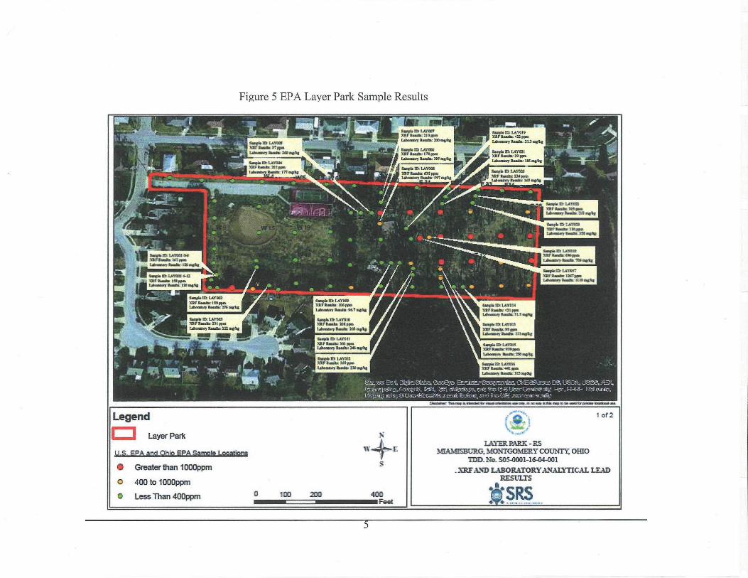
Figure 5 EPA Layer Park Sample Results
3=0AM IAVICII 414 bosta pqm
• 121
ICU Win ppm
IkepIN 10 tAVON W Iambs lime Lainnow WNW Mae. -
Imp& Ilk 1,KYOU )2t 211 1 Iris I ?imp%
Limp14.162 T.J.1111)7 711711•40., 211pen Woman lizaks: =mak
.... Dm* la LIM1111 Wardle ['Yips I Calmed/ 11/0/a7 MS Ai
Nap.lb 2.061,31P 32F &mar ,M EAVragrif loria.,111 sat(
Am* LAIRCIL XICF 'pa LAMM, MI... ILS
implant:UMW Pb pilas
1Lermeant Ramin•IVr
3.01. Irt LIMO XI/1mM. bed pm Lifeamnr UMW: were
IlLlD XI.Itmaka MI pin Lemont Sri 210 er.l.
boob VI L.41,11 MitFI Ipm [Ammo Raids: 1114.440
%alga 1111k LAYOloi XIDIr Ilanstv 441. es
• 11..3
leak IQ Ler 10 XV WWI., Mews Lamm* Lads' 376 ei.14
ctlEa.5.427_* I I H-44- 0:74 onto,
Z.IFICtZEM'S-S :1105 .111ir
LATER PARK -RS NUAMISEURG, MONTGOMERY COUNT' OHM
TDD. No. SOS-0001-16-04-001 . IRE' AND LABORATORYANALYTICAL LEAD
RESULTS
I$lb LAITIII 7.7ir tad= WK. lahrwary10•00: 11.101ftla
lin* fa C.C(01.1 701Flosilla.195 2.01000r5 Ihaia: 161 Eels
Sands RI LOW Itania•SOPppda
lakamal, Ibmir.23/1.01%
Legend
Layer Park
1a...M64110.22i2-geitaiM101SLUSILti202
• Greater than 1000ppm
o 400 to 1000pprn
▪ Less Than 400ppm 400 Feet
100 200
5

34440Mr ttr1,031 741, itamalm 33 ppm 1pheniery /1•44114 23.111#11,
Ample 33 Mitt! 12-24 ARP !MARNA 11111 ppm L■birdery tkomilz. 33 7 Auto
EOG Feet
2E0 125
Legend I=1 Layer Park
U.S. EPA and Ohio EPA Sample Locations
Greater than 10a0 ppm
400- to 10130, ppm,
Less Than 4411D ppm
' APTRIEinNCR= X/411 Rmsulla- 114 MAR
Rowe 13 11111010 30110 .14.4uar 4A ppm Litomlerp Romala 33.4 male
tamp&ID tetrato0-i2 YAP Rowan gmn
194mm114111. PERM 1334
Pereplp MAIM r1.1sic 133 PPR
Lthoonker Raab. 41 imp1E3
&Iö.ID tscPon G.! 2 PAP Rameler MI:pm tateepterp Roans 431 mil;
&mita 113,14-ftitla AO' Ammar 34 ppm Calpeolmp Knot: 513 mem
Zomple13 11C013A11 ARA timahr 111 pm Latespiery Ramat MA 491,2
Smnp• PCP1313 042 XRP Ibmik 431 gen 1AIRMay 2311mARR
334031.113. MAIM T2-24 xlar hews. .rts fipn labanskry IlleadIrc ISA mote
ERMA.It1 iltkn4 042 ARP 41 ppm Lahmalorp PRAM* 51.1 enohe
Poppl•Xl. econ114 12-24 xlik /4•444:4 311ppm
111114141.7- emir 111 MAR
Ilamplal 11131313 f1.111 suld, 41 ppm Laperiary Asses. 23 AV%
Rartp4s10 11511315 XRP Rsaullip =ppm Labeeptcy 11amilw 112 mak,
Sample CP VCR CORR 11mpflp 11fipprn
lalloralref Reattm 111tr4pkg
111: PC01303 PAM PlamplIA 223 ppm Latembel lermem
2441144 10T. MR= ttmeAlp pt..
Letteskat, ftwatic 41.70,1311g
II ix- .14
01114016.111
Lvf, IOW wars.a.s.,56163g. Le, 4Mt, avgea-L-v. 4,404,0" iko ef.,451.tr-ve.,.5,1k4voinev -t I3cum.
Wog FIVC-rllf LTA!!
212
-ay...
LAYER PARK - RS MIAMISBURG, MONTGOMERY COUNTY, OHIO
1DD. No. S05-0001-16 01 001
lalFAND LABORATORY ANALITIC_AL LEAD RESULTS
SRS
Figure 6 EPA MVHPC Sample Results
ATTACHMENT 1
EJ ANALYSIS Layer Park
Miami Township, OH June, 2016
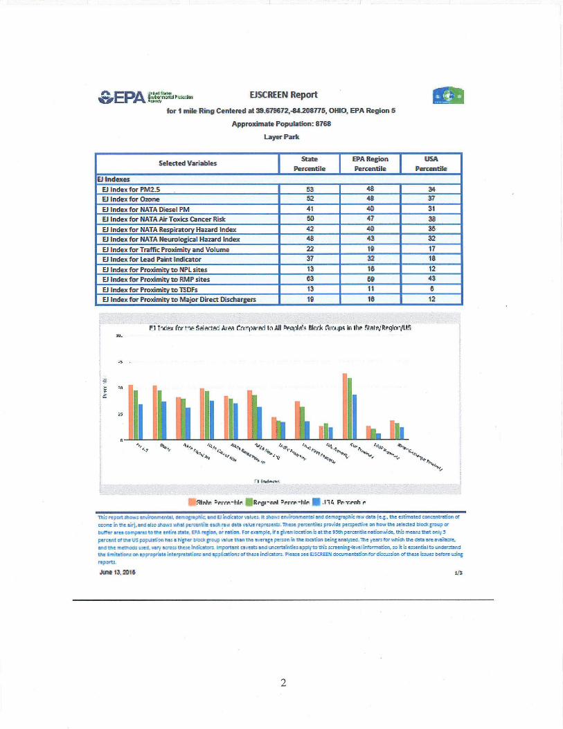
EPA EJSCREEN Report
tort mile Ring Centered at 39.679672,44208775, 01110, EPA Region 5
Approximate Population: 8768
Layer Park
Selected Variables I Percentile
EPA Region
Percentile I PercenPercentile
State USA
Et Indexes
El Index for Ph42.5 53 48 34
El Index for Orone 52 48 37
El Index for RATA Diesel PM 41 40 31
IFJ Index for RATA Air Toxics Cancer Flisk 50 47 38
El Index for NATA Respiratory Hazard Index 42 40 35
El Index for NATA Neurological Hazard Index 48 43 32
El Index for Traffic Proximity and Volume 22 19 17
El Index for Lead Paint Inchcator 37 32 18
El Index for Proximity to NPL sites 13 16 12
El Index for Proximity to FIMP sites 53 ao 43
El Index for Proximity to TSDfs 13 11 a
E1 Index for Proximity to Major Direct Dischargers 19 16 12
PI T-c'ex fnr r -tn- AinCirroprivi tn Autk.opilli. Rinrk nirAll; in thi tatevt2Pgicall.K tu_
Iii II -111 h , , 4.4.4
•44-• 't•
r
rrrfuI111 R rot - nnl Dern. -t dr. 1111 .114 Pe T.rnh r
This report shows eroeirounnente, demographic, and EJ indkertor vetoes. It shows eruirifonrrovrtet! and demographic row data the esernated corecentreicn oe
ozone in the aid,. and nim thee: htat peroullile code re w data value reprcant. These percen6les provide perspective an how the selethed bind: group cc
haler area cm inpa-ez tome entire :tete. EPA regg-on, cr nation. For e_larnpre, liegive h'helithli et tn. 95th perrentile rtlerrelth this means that Dray 5
percurd Gethe us population has a hisher tied1 grew value than the emerge person in the locution teing analysed. The years foe which the clMa etcELAiilalare,
and the methods used, vary ed-oos thee Indio ators. Impertant al veata end Lhoert.arrilies apply to tris omen in tie vet inTernaati on. do k is es seals] to understand the imitations on appropriate interpretations end *pet:eon:of thwe indicators. Please aee EISCREEN documentation for di:my:len, oe these before wing
reports.
June 13. 2016 ifs
2
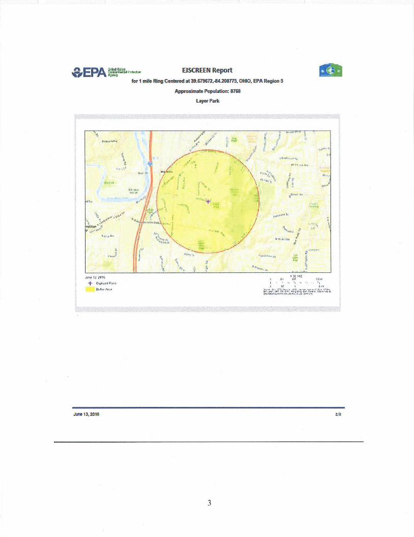
drk Agaiwr. EISCREEN Report EPA tt-r/mrryttrial vs-1.1t. fi;1297,
fort mile Ring Centered at 39.679672,-84.208775, OHIO, EPA Region 5 It 1
Approximate Population: 8768
Layer Park
JO! IS 211,i
attatievall.utti
Eititkr fn
1 •it It t Ikt. i rtt
i le"
ala, NI Ur,: 1.1434 1111.4 .7.310C 4.111.6,12
June 13,2015 2,1
3
&EPA Mr-r"P-- EISCREEN Report
foil mile Ring Centered at 39.578672.414208775. OHIO. EPA Region 5
Approximate Population: Mil
Layer Park
Selected Variables Raw Data
State Mtg.
Me in State
EPA .
Region Ave.
991e in EPA .
Ream
USA An.
Me in USA
Environmental Indicators Particulate Matter IFIA IS in menrill 12 11.8 80 10.8 82 9.78 92
Ozone {PO} 511.0 47A 86 444 06 46.1 n HATA Diesel PM (ogiran/l. 0.706 0.809 67 0-712 80-70th 0.824 80-70th HATA Cancer Risk ilifetirne risk per midair 45 41 65 42 50-701h 49 00-60th NATA Respiratory Hazard Indee 1.9 1.4 77 1.5 70-80th 2.3 50-60th NATA Neurological Hazard Index* 01168 0.079 72 0.067 70-89th 0.083 70-80th Traffic Proximity and Volume foray mer counticiMnet to road) 110 74 83 62 83 110 76 Lead Paint Indicator p$Pre-060 ft:vire 0_42 0-43 56 0.4 58 0.3 69 NPIL Proddmity l2re sountlIrn drum) 0.19 0.089 03 0.088 91 0.008 89 MAP Proximity (f.ty =Afton cialante) 0.077 0.3 10 0.33 20 0.31 25 TSDF Proximity (facility courrtelon rfestance) 0-14 0.058 93 0-051 93 0.054 02 Water Discharger Proximity iftesigly entwitllon distance) 0.59 0.23 22 023 91 0.25 110
Demographic Indicators
Demographic Index 28% 26% 67 28% 85 35% 49
Minority Population 17% 19% 68 24% 60 38% 38
Low Income Population 39% 34% 64 32% 67 34% 63
Linguistically Isolated Population 3% 1% 88 2% 78 5% 64
Population With Less Than High School Education 14% 12% 69 12% 70 14% 60
Population Under 5 years of age 8% 6% 60 8% 67 7% 65
Population or 64 years of age 18% 14% 73 13% 76 13% 78 The Natiorwt-Scale Air Tories Assessment (NATA) is EPA's angoirc compretiensiee enstutnion of air toxic in the tired Stet,... EPA developed the HATA to
miorkize air twit, emersion sources, and locations of interest for Nether study. It is important to remember that NATA prides broad estimates of hearth rids over geographic area; of the andstry. not definitiee rids to specific individuals or bastions More Mfor motion on the NATA arefysis tan be found
at: Ittp://yrydrsepa.gavAtolaWnatemainfoulle.A.htmt
For additional information, see: vivevo .epa.govienvironmentaljustice
EISCREEM is a screening tool for pre-deconaill use only. at can, help kit:Miff areas that mai 'aerrarrt ad:gimlet oxisideralicin. analysis, or outreach. It does not prtle a basis for de&Son-rrisairg, but it mey help identify putentild amid at ID concern. Usus should keep in mind that screening tools are sutied to wtztantiai
uncertainty in their demographic arid ermyironrmantat data, particularly 10E11 footing at wall eographic areas. Important caveats and uncertainties apply to this
screening-level information. no it is essertial to understand the limintians an appropriate interpretatiara end applications at the indicators_ Please see
EISCREEN documentation for di:pi:Liars of 'these issues before tthvA. report, Thin screening tool does not provide data cm every ertaironmerrtal impact and demographic factor that may be relevant to a partindar bonetion. ElSEPPIN output should be supplemented with additional information end loi..mt knowledge before taking any action to address potential El concerns.
June I& 2DIE 315
4
ATTACHMENT 2
DETAILED CLEANUP CONTRACTOR ESTIMATE
HAS BEEN REDACTED – ONE PAGE
NOT RELEVANT TO SELECTION
OF REMOVAL ACTION
ATTACHMENT 3
INDEPENDENT GOVERNMENT COST ESTIMATE
HAS BEEN REDACTED – TWO PAGES
NOT RELEVANT TO SELECTION
OF REMOVAL ACTION

ATTACHMENT 4
U.S. ENVIRONMENTAL PROTECTION AGENCY REMOVAL ACTION
ADMINISTRATIVE RECORD FOR THE
LAYER PARK SITE MIAMISBURG, MONTGOMERY COUNTY, OHIO
ORIGINAL
AUGUST, 2016
NO. SEMS ID DATE AUTHOR RECIPIENT TITLE/DESCRIPTION PAGES
1 928918 Undated Ohio EPA File Residential Sampling Map 1 (Document withheld from the public AR due to Personally-Identifying Information)
2 918770 8/1/07 ATSDR Public ToxFAQs Fact Sheet - Lead - 2 CAS #7439-92-1
3 919199 8/1/07 ATSDR Public ToxFAQs Fact Sheet - 2 Arsenic - CAS #7440-38-2
4 928913 7/28/16 Wolfe, S., U.S. EPA
Glum, S., Ohio EPA
Email re: Request for ARARs for the Layer Park Site
1
5 928914 7/29/16 Glum, S., Ohio Wolfe, S., U.S. Email re: ARARs for the 6 EPA EPA Layer Park Site (ARARs
Table Attached)
6 928915 4/5/16 Proffitt, M., Ohio EPA
Clements, M., U.S. EPA
Ohio EPA Referral Package for Layer Park
61
7 928916 2/26/16 Vorwerk, W., Ohio EPA
File State-Lead Site Assessment Work Plan for Layer Park
42
8 928917 7/25/16 Baldino, R., SRS
Wolfe, S., U.S. EPA
Final Removal Assessment Report for Layer Park
102
9 Wolfe, S., U.S. Ballotti, D., Action Memorandum re: EPA U.S. EPA Request for a Time-Critical
Removal Action and an Exemption from the $2 Million Statutory Limit at the Layer Park Site (PENDING)
8