Embed Size (px)
Citation preview
U.S. Department of Housing and Urban Development New Jersey Superstorm Sandy Community Development Block Grant- Disaster Recovery Program Neighborhood Community Revitalization Program 8-Step Floodplain Analysis - Executive Order 11988, HUD 24 CFR 55 NCR38958 Sea Isle City Streetscape Revitalization
1
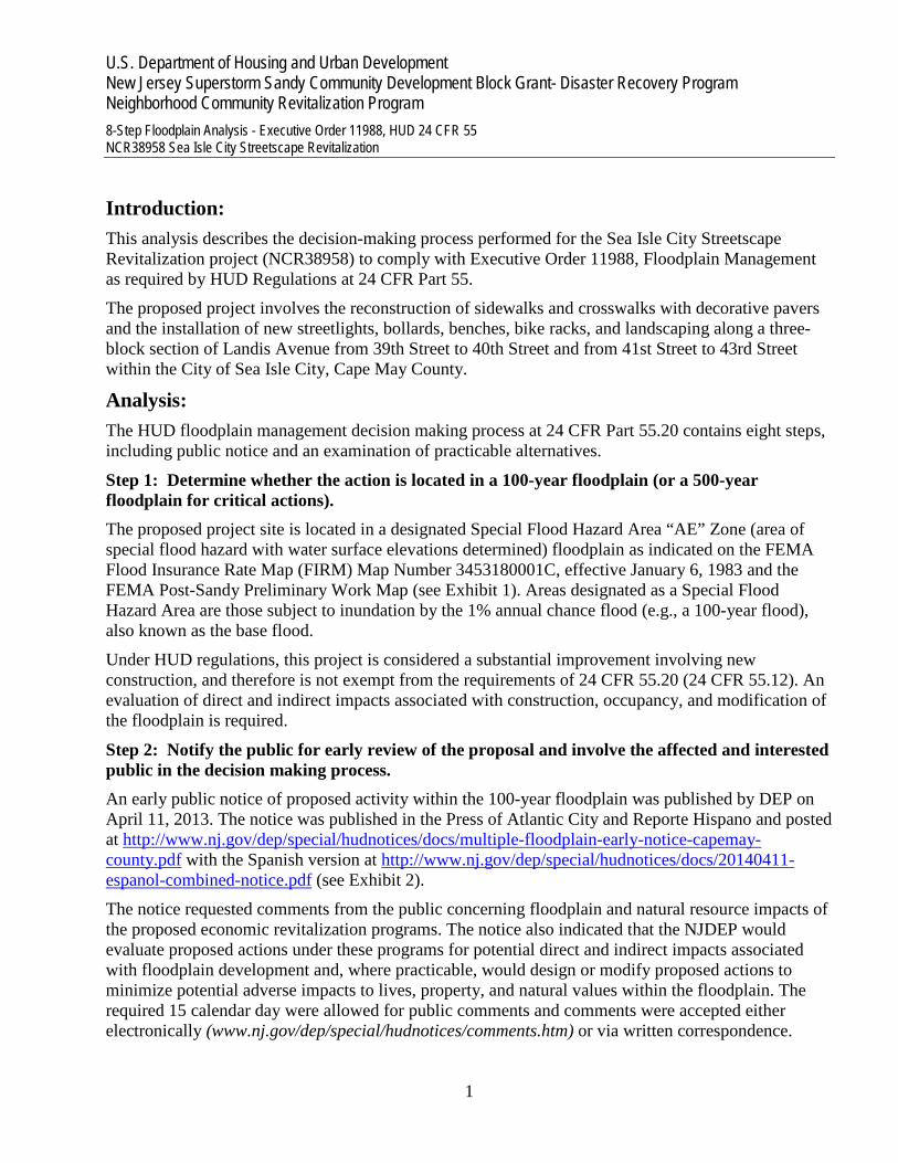
Introduction: This analysis describes the decision-making process performed for the Sea Isle City Streetscape Revitalization project (NCR38958) to comply with Executive Order 11988, Floodplain Management as required by HUD Regulations at 24 CFR Part 55.
The proposed project involves the reconstruction of sidewalks and crosswalks with decorative pavers and the installation of new streetlights, bollards, benches, bike racks, and landscaping along a three-block section of Landis Avenue from 39th Street to 40th Street and from 41st Street to 43rd Street within the City of Sea Isle City, Cape May County.
Analysis: The HUD floodplain management decision making process at 24 CFR Part 55.20 contains eight steps, including public notice and an examination of practicable alternatives.
Step 1: Determine whether the action is located in a 100-year floodplain (or a 500-year floodplain for critical actions). The proposed project site is located in a designated Special Flood Hazard Area “AE” Zone (area of special flood hazard with water surface elevations determined) floodplain as indicated on the FEMA Flood Insurance Rate Map (FIRM) Map Number 3453180001C, effective January 6, 1983 and the FEMA Post-Sandy Preliminary Work Map (see Exhibit 1). Areas designated as a Special Flood Hazard Area are those subject to inundation by the 1% annual chance flood (e.g., a 100-year flood), also known as the base flood.
Under HUD regulations, this project is considered a substantial improvement involving new construction, and therefore is not exempt from the requirements of 24 CFR 55.20 (24 CFR 55.12). An evaluation of direct and indirect impacts associated with construction, occupancy, and modification of the floodplain is required.
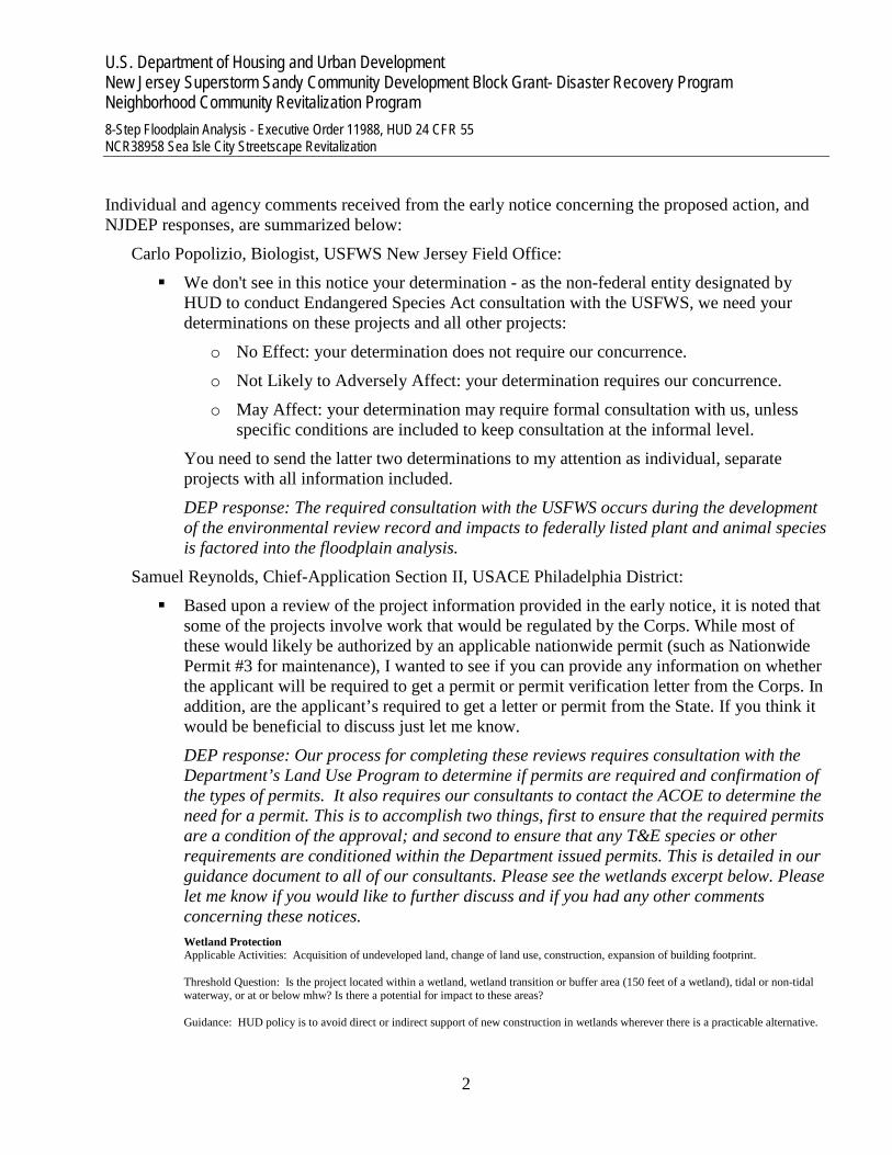
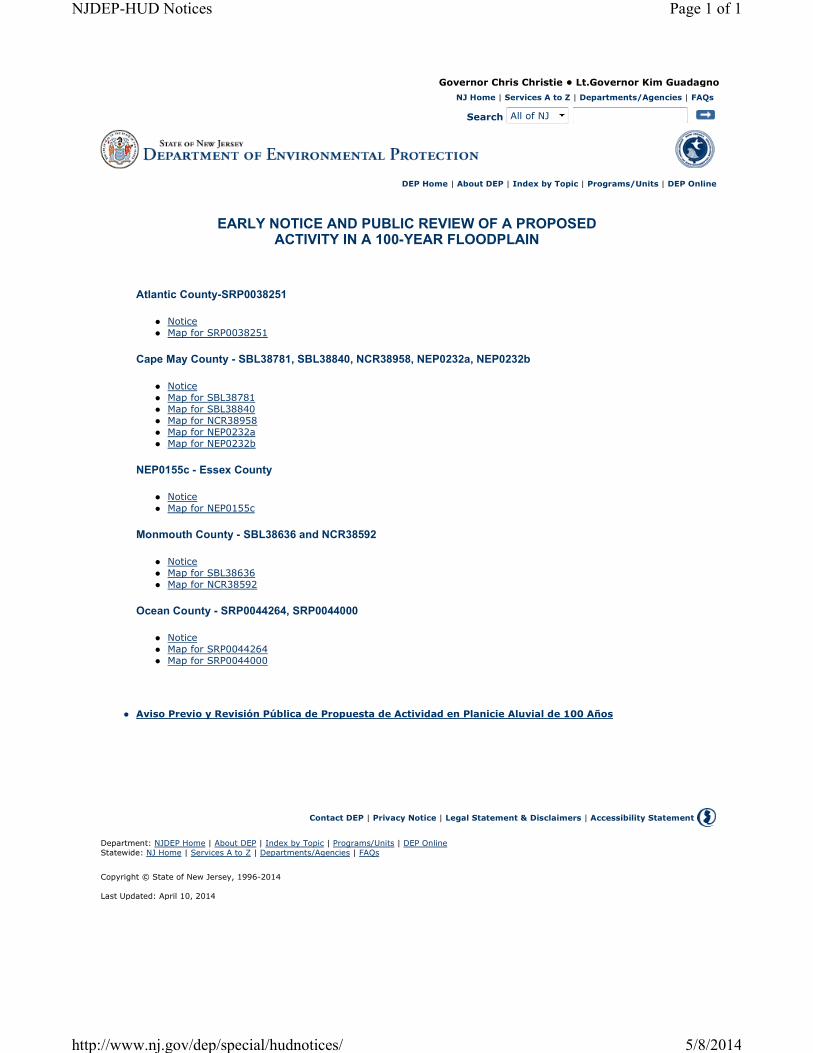
Step 2: Notify the public for early review of the proposal and involve the affected and interested public in the decision making process. An early public notice of proposed activity within the 100-year floodplain was published by DEP on April 11, 2013. The notice was published in the Press of Atlantic City and Reporte Hispano and posted at http://www.nj.gov/dep/special/hudnotices/docs/multiple-floodplain-early-notice-capemay-county.pdf with the Spanish version at http://www.nj.gov/dep/special/hudnotices/docs/20140411-espanol-combined-notice.pdf (see Exhibit 2).
The notice requested comments from the public concerning floodplain and natural resource impacts of the proposed economic revitalization programs. The notice also indicated that the NJDEP would evaluate proposed actions under these programs for potential direct and indirect impacts associated with floodplain development and, where practicable, would design or modify proposed actions to minimize potential adverse impacts to lives, property, and natural values within the floodplain. The required 15 calendar day were allowed for public comments and comments were accepted either electronically (www.nj.gov/dep/special/hudnotices/comments.htm) or via written correspondence.
U.S. Department of Housing and Urban Development New Jersey Superstorm Sandy Community Development Block Grant- Disaster Recovery Program Neighborhood Community Revitalization Program 8-Step Floodplain Analysis - Executive Order 11988, HUD 24 CFR 55 NCR38958 Sea Isle City Streetscape Revitalization
2
Individual and agency comments received from the early notice concerning the proposed action, and NJDEP responses, are summarized below:
Carlo Popolizio, Biologist, USFWS New Jersey Field Office:
We don't see in this notice your determination - as the non-federal entity designated by HUD to conduct Endangered Species Act consultation with the USFWS, we need your determinations on these projects and all other projects:
o No Effect: your determination does not require our concurrence.
o Not Likely to Adversely Affect: your determination requires our concurrence.
o May Affect: your determination may require formal consultation with us, unless specific conditions are included to keep consultation at the informal level.
You need to send the latter two determinations to my attention as individual, separate projects with all information included.
DEP response: The required consultation with the USFWS occurs during the development of the environmental review record and impacts to federally listed plant and animal species is factored into the floodplain analysis.
Samuel Reynolds, Chief-Application Section II, USACE Philadelphia District:
Based upon a review of the project information provided in the early notice, it is noted that some of the projects involve work that would be regulated by the Corps. While most of these would likely be authorized by an applicable nationwide permit (such as Nationwide Permit #3 for maintenance), I wanted to see if you can provide any information on whether the applicant will be required to get a permit or permit verification letter from the Corps. In addition, are the applicant’s required to get a letter or permit from the State. If you think it would be beneficial to discuss just let me know.
DEP response: Our process for completing these reviews requires consultation with the Department’s Land Use Program to determine if permits are required and confirmation of the types of permits. It also requires our consultants to contact the ACOE to determine the need for a permit. This is to accomplish two things, first to ensure that the required permits are a condition of the approval; and second to ensure that any T&E species or other requirements are conditioned within the Department issued permits. This is detailed in our guidance document to all of our consultants. Please see the wetlands excerpt below. Please let me know if you would like to further discuss and if you had any other comments concerning these notices. Wetland Protection Applicable Activities: Acquisition of undeveloped land, change of land use, construction, expansion of building footprint. Threshold Question: Is the project located within a wetland, wetland transition or buffer area (150 feet of a wetland), tidal or non-tidal waterway, or at or below mhw? Is there a potential for impact to these areas? Guidance: HUD policy is to avoid direct or indirect support of new construction in wetlands wherever there is a practicable alternative.

U.S. Department of Housing and Urban Development New Jersey Superstorm Sandy Community Development Block Grant- Disaster Recovery Program Neighborhood Community Revitalization Program 8-Step Floodplain Analysis - Executive Order 11988, HUD 24 CFR 55 NCR38958 Sea Isle City Streetscape Revitalization
3
Impacts to wetlands from new construction require the 8-step decision making process to be completed. Projects may be approved if there is no practicable alternative outside the wetland area. Use NJDEP HUD Environmental Review Tool, Wetlands and the Mean High Water Buffer Zone (150 ft.) layers at http://bit.ly/1dREWkD and conduct a site inspection. If the project will impact, or has the potential to impact wetlands, transition/buffer areas, or areas below mhw, consult with DLUR for a JD. A Water Quality Certificate may be needed. If wetlands within 1000' of mhw will be impacted, the US Army Corp of Engineers (USACOE) must also be consulted. Wetlands within 1,000 feet of mhw are regulated by both NJDEP and the USACOE. Work proposed at or below the high water line, e.g. along beaches, dunes areas/bulkheads, etc. (which may be above mhw line) or in areas that may not have regulated vegetated wetlands present may also be regulated by the USACOE. Provide a pdf map of the wetlands layer from the NJDEP HUD Environmental Review Tool. See end note for file naming convention Reference the map in the Compliance Documentation section of the CEST or EA. Provide a pdf of any DLUR - JD document. Consultation Contact: Ryan Anderson, NJDEP DLUR, 609-292-1230, [email protected] USACOE NY District-Eastern Section (Passaic, Essex, Union, Middlesex, and Monmouth): Steve Ryba, 917-790-8512, [email protected] USACOE NY District (Hudson and Bergen): Jim Cannon, [email protected], 917-790-8412 USACOE Philadelphia District (all other NJ counties): Sam Reynolds, 215-656-5715, [email protected],
Step 3: Identify and evaluate practicable alternatives. Several alternatives to the proposed action within the 100-year floodplain were considered:
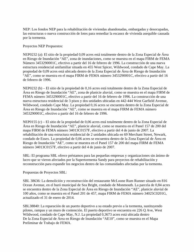
Alternative 1: Relocate the Proposed Action Outside of the 100-year floodplain Due to its geography and physical shape as part of a barrier island, much of Sea Isle City is considered to be within the 100-year floodplain. A GIS analysis using the latest FEMA Preliminary Work Map mapping (Exhibit 3) was performed to further characterize land parcels and floodplain designations in Sea Isle City:
Approximately 94% of parcels within the city are classified as being entirely or partially within the 100 year floodplain (Zones “AE”, “AO” and “VE”).
Approximately 5% of parcels within the city are classified as being entirely or partially outside the 100-year floodplain but susceptible to the 0.2 percent annual chance flood hazard (i.e. the 500-year flood) – the “Shaded X” Zone.
Less than 1% of parcels in the city are classified as being entirely or partially outside the 100-year floodplain (Zone “X”) and 500-year floodplain.
Therefore, relocating the proposed project to another available nearby parcel would not necessarily avoid floodplain effects.
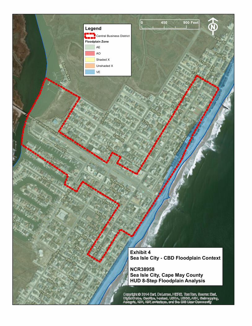
The intent of the project is to assist in the revitalization of the central business district (CBD) of Sea Isle City; therefore alternative locations outside of the CBD would not meet the project intent. Relocating the project from the proposed location to another portion of the CBD would not avoid floodplain impacts, as the entire CBD of the city is located within the AE or VE 100-year floodplain zone (Exhibit 4).

U.S. Department of Housing and Urban Development New Jersey Superstorm Sandy Community Development Block Grant- Disaster Recovery Program Neighborhood Community Revitalization Program 8-Step Floodplain Analysis - Executive Order 11988, HUD 24 CFR 55 NCR38958 Sea Isle City Streetscape Revitalization
4
Alternative 2: No Action or Alternative Actions that Serve the Same Purpose A no action alternative was considered and rejected because the no action alternative would not address the post-Sandy economic revitalization needs of Sea Isle City. Similarly, no alternative actions that would serve the same purpose and would avoid construction within the 100-year floodplain were identified, as the entire CBD of the city is within a designated flood hazard area.
Superstorm Sandy had a widespread and lasting impact on the economy of New Jersey’s shore communities. The storm caused substantial damage to commercial property, caused short- and long-term business operations losses, and negatively affected tourism visitation.
Statewide, tourism accounts for approximately 10% of total employment and almost 7% of the state’s economic output. Tourism is the major component of the local economy. In Cape May County, direct tourism sales were $5.5 million in 2013. Employment in the tourism industry (including direct and indirect/induced employment) in Cape May County was 35,801—accounting for an estimated 68.2% of total county employment. State and local tax receipts attributed to tourism were $511.4 million for Cape May County in 2013, accounting for an estimated 11.1% of total state tourism income (New Jersey Division of Travel and Tourism, The Economic Impact of Tourism in New Jersey, 2013, Prepared by Tourism Economics, Inc).
In Sea Isle City, approximately 31% of employment in the borough is comprised of jobs in three tourism-related industry sectors—the Arts, Entertainment & Recreation sector; the Accommodations and Food Services sector; and the Retail Sales sector (U.S. Census Bureau, OnTheMap Application and Longitudinal Employer-Household Dynamics, Work Area Profile Analysis, Q2-2011 data).
The proposed project is located in the City’s central business area which includes Zone C-1 Central Business District, C-3 Motel Business District, and P-3 Public Use and Recreation District zoning classifications.
The economic impact to the business district from Superstorm Sandy was substantial. The entire population of the city was displaced as a result of the evacuation in response to the storm forecast. Following the storm, residents were not allowed back onto the island for several days. It is estimated that for a period of several weeks, as a result of the extent of damage sustained in residences and businesses, approximately one- third of the city’s year-round population was displaced. The businesses themselves were closed from one to six months following the storm, depending on the extent of damage they sustained. The dollar value of business loss from Superstorm Sandy is roughly estimated at $6 million. This figure includes both the loss of rental revenue, which decreased by 5% in 2013, and the loss of business from a decreased number of visitors to the city in 2013.
This project allows Sea Isle City to proceed with pre-Super Storm Sandy plans for revitalizing the business district through streetscape improvements. In October of 2012, the City was in the process of preparing streetscape designs for the central business district. The streetscape improvements were part of the overall “Beach to Bay Corridor” initiative, a multiphase project developed through a partnership with Cape May County which is central to the City’s Capital Improvement Program.
The proposed project area was severely impacted during Superstorm Sandy. Many ground floor businesses were damaged from flood waters, requiring almost total reconstruction. The proposed
U.S. Department of Housing and Urban Development New Jersey Superstorm Sandy Community Development Block Grant- Disaster Recovery Program Neighborhood Community Revitalization Program 8-Step Floodplain Analysis - Executive Order 11988, HUD 24 CFR 55 NCR38958 Sea Isle City Streetscape Revitalization
5
project will complement the improvements already made in the business district related to storm recovery.
Step 4: Identify Potential Direct and Indirect Impacts of Associated with Floodplain Development. While the proposed streetscape revitalization improvements would occur within the 100-year floodplain, the overall design would have minimal effect on potential damage as a result of the flooding.
The project would replace existing concrete-slab sidewalks with decorative pavers and include the addition of street lighting, benches, bicycle racks, bollards and street trees. The project would result in no net change in impervious area or floodplain development within the urbanized CBD.
Overall, construction of the proposed project would not result in significant adverse impacts to flood levels, flood risk, or the flow of flood waters on the project site or surrounding areas. Therefore, the proposed project would be compliant with the National Flood Insurance Act of 1968 (44 CFR § 59) and Executive Order 11988 on Floodplain Management (42 FR 26951).
Step 5: Where practicable, design or modify the proposed action to minimize the potential adverse impacts to lives, property, and natural values within the floodplain and to restore, and preserve the values of the floodplain. As noted in Step 4, the proposed project would have no effect on flood levels or the threat of damage to adjacent properties.
Step 6: Reevaluate the Alternatives. The proposed action is viewed as the most practicable alternative by avoiding adverse impacts to the floodplain in the local vicinity while helping to meet the community’s need for economic revitalization to support local employment and the tourism industry. Relocation of the project to another site within the Sea Isle City CBD would not avoid or further minimize impacts to the floodplain nor meet the intent of the project. The project, as proposed, would minimize potential hazards to human safety, health, and welfare.
The no action alternative also remains impracticable because it will not satisfy the need for post-Sandy economic revitalization within this substantially impacted community.
Step 7: Determination of No Practicable Alternative It is our determination that there is no practicable alternative to locating the project in the flood zone. This is due to: 1) the need to revitalize the tourism economy of Sea Isle City through improvements within the CBD; 2) the lack of alternative locations outside of the 100-year floodplain related to the physical geography of this barrier island community; and 3) the limited scope and impact of the proposed project related to impacts on human health, public property, and floodplain values.
A final public notice will be published in accordance with HUD requirements. The final notice will detail the reasons why the project must be located in the floodplain, a list of alternatives considered, and measures taken to minimize adverse impacts and preserve natural and beneficial floodplain values.
U.S. Department of Housing and Urban Development New Jersey Superstorm Sandy Community Development Block Grant- Disaster Recovery Program Neighborhood Community Revitalization Program 8-Step Floodplain Analysis - Executive Order 11988, HUD 24 CFR 55 NCR38958 Sea Isle City Streetscape Revitalization
6
Step 8: Implement the Proposed Action Implementation of the proposed action may require additional local and state permits, which could place additional design modifications or mitigation requirements on the project.

U.S. Department of Housing and Urban Development New Jersey Superstorm Sandy Community Development Block Grant- Disaster Recovery Program Neighborhood Community Revitalization Program 8-Step Floodplain Analysis - Executive Order 11988, HUD 24 CFR 55 NCR38958 Sea Isle City Streetscape Revitalization
7
Exhibit 1: Floodplain Map

Copy
right:
© 20
14 Es
ri, De
Lorm
e, HE
RE, T
omTo
m, So
urce:
Esri,
Digit
alGlob
e, Ge
oEye
, i-cu
bed,
USDA
,US
GS, A
EX, G
etmap
ping,
Aerog
rid, IG
N, IG
P, sw
isstop
o, an
d the
GIS
Use
r Com
munit
y
NJDEP
HUD E
nviron
menta
l Revi
ew To
olNe
w Jers
ey De
pt of
Enviro
nmen
tal Pr
otectio
n - HU
D Envi
ronme
ntal Re
view T
ool
Flood
plain M
anagem
ent -
FEMA P
relim
inary
Work
Map
Appli
cation
ID#:
Addre
ss:Mu
nicipa
lity:
NCR3
8958
Landis
Aven
ue fro
m 39t
h St to
40th
St and
41st S
t to 43
rd St
Sea Isl
e City
1:2,40
01 in
ch = 2
00 fee
t0
400200
Feet
Propo
sed Ac
tion S
itePre
limina
ry Wo
rk Ma
pZo
neA
AE AOVE Sh
aded
X

U.S. Department of Housing and Urban Development New Jersey Superstorm Sandy Community Development Block Grant- Disaster Recovery Program Neighborhood Community Revitalization Program 8-Step Floodplain Analysis - Executive Order 11988, HUD 24 CFR 55 NCR38958 Sea Isle City Streetscape Revitalization
8
Exhibit 2: Early Notice and Public Review
Governor Chris Christie • Lt.Governor Kim Guadagno
NJ Home | Services A to Z | Departments/Agencies | FAQs
Search All of NJ
DEP Home | About DEP | Index by Topic | Programs/Units | DEP Online
EARLY NOTICE AND PUBLIC REVIEW OF A PROPOSED ACTIVITY IN A 100-YEAR FLOODPLAIN
Atlantic County-SRP0038251
� Notice
� Map for SRP0038251
Cape May County - SBL38781, SBL38840, NCR38958, NEP0232a, NEP0232b
� Notice
� Map for SBL38781
� Map for SBL38840
� Map for NCR38958
� Map for NEP0232a
� Map for NEP0232b
NEP0155c - Essex County
� Notice
� Map for NEP0155c
Monmouth County - SBL38636 and NCR38592
� Notice
� Map for SBL38636
� Map for NCR38592
Ocean County - SRP0044264, SRP0044000
� Notice
� Map for SRP0044264
� Map for SRP0044000
� Aviso Previo y Revisión Pública de Propuesta de Actividad en Planicie Aluvial de 100 Años
Contact DEP | Privacy Notice | Legal Statement & Disclaimers | Accessibility Statement
Department: NJDEP Home | About DEP | Index by Topic | Programs/Units | DEP Online
Statewide: NJ Home | Services A to Z | Departments/Agencies | FAQs
Copyright © State of New Jersey, 1996-2014
Last Updated: April 10, 2014
Page 1 of 1NJDEP-HUD Notices
5/8/2014http://www.nj.gov/dep/special/hudnotices/
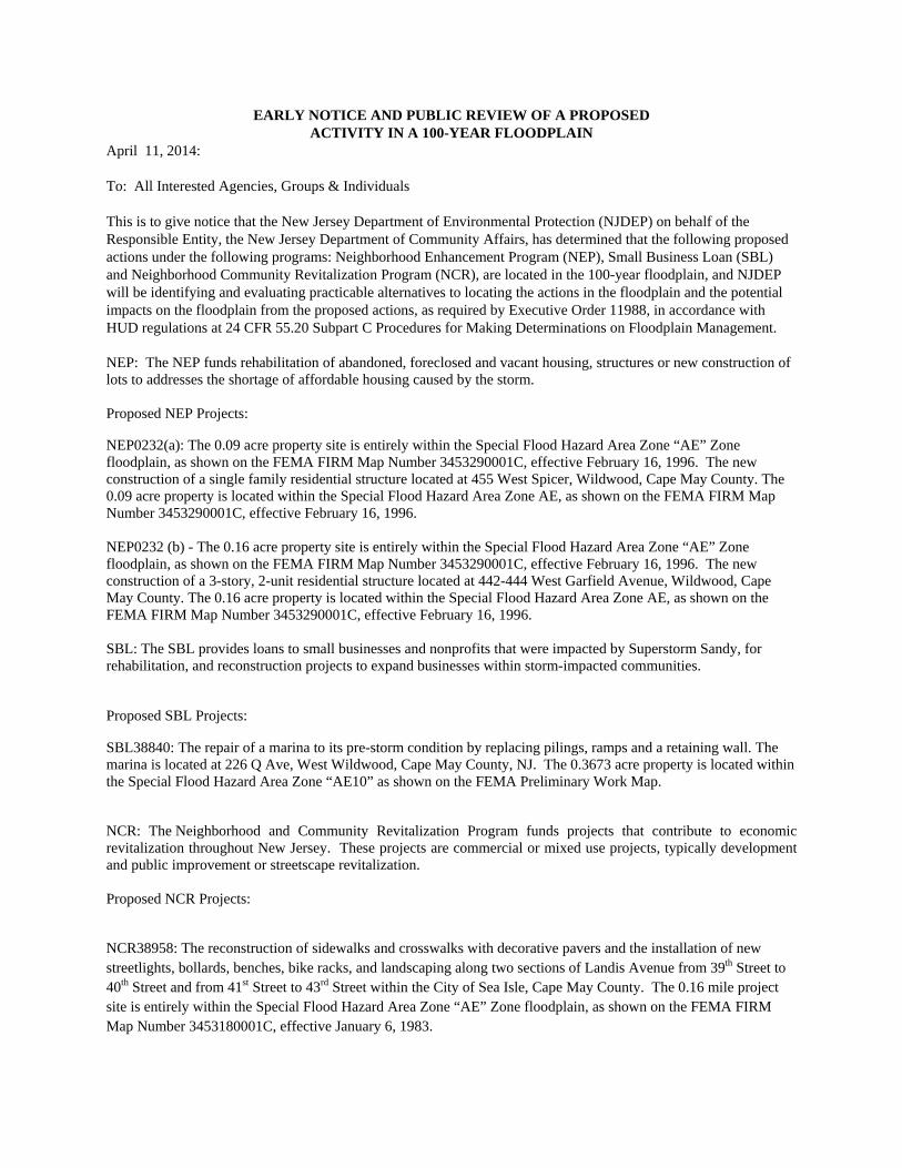
EARLY NOTICE AND PUBLIC REVIEW OF A PROPOSED ACTIVITY IN A 100-YEAR FLOODPLAIN
April 11, 2014: To: All Interested Agencies, Groups & Individuals This is to give notice that the New Jersey Department of Environmental Protection (NJDEP) on behalf of the Responsible Entity, the New Jersey Department of Community Affairs, has determined that the following proposed actions under the following programs: Neighborhood Enhancement Program (NEP), Small Business Loan (SBL) and Neighborhood Community Revitalization Program (NCR), are located in the 100-year floodplain, and NJDEP will be identifying and evaluating practicable alternatives to locating the actions in the floodplain and the potential impacts on the floodplain from the proposed actions, as required by Executive Order 11988, in accordance with HUD regulations at 24 CFR 55.20 Subpart C Procedures for Making Determinations on Floodplain Management. NEP: The NEP funds rehabilitation of abandoned, foreclosed and vacant housing, structures or new construction of lots to addresses the shortage of affordable housing caused by the storm. Proposed NEP Projects:
NEP0232(a): The 0.09 acre property site is entirely within the Special Flood Hazard Area Zone “AE” Zone floodplain, as shown on the FEMA FIRM Map Number 3453290001C, effective February 16, 1996. The new construction of a single family residential structure located at 455 West Spicer, Wildwood, Cape May County. The 0.09 acre property is located within the Special Flood Hazard Area Zone AE, as shown on the FEMA FIRM Map Number 3453290001C, effective February 16, 1996. NEP0232 (b) - The 0.16 acre property site is entirely within the Special Flood Hazard Area Zone “AE” Zone floodplain, as shown on the FEMA FIRM Map Number 3453290001C, effective February 16, 1996. The new construction of a 3-story, 2-unit residential structure located at 442-444 West Garfield Avenue, Wildwood, Cape May County. The 0.16 acre property is located within the Special Flood Hazard Area Zone AE, as shown on the FEMA FIRM Map Number 3453290001C, effective February 16, 1996. SBL: The SBL provides loans to small businesses and nonprofits that were impacted by Superstorm Sandy, for rehabilitation, and reconstruction projects to expand businesses within storm-impacted communities.
Proposed SBL Projects:
SBL38840: The repair of a marina to its pre-storm condition by replacing pilings, ramps and a retaining wall. The marina is located at 226 Q Ave, West Wildwood, Cape May County, NJ. The 0.3673 acre property is located within the Special Flood Hazard Area Zone “AE10” as shown on the FEMA Preliminary Work Map.
NCR: The Neighborhood and Community Revitalization Program funds projects that contribute to economic revitalization throughout New Jersey. These projects are commercial or mixed use projects, typically development and public improvement or streetscape revitalization. Proposed NCR Projects:
NCR38958: The reconstruction of sidewalks and crosswalks with decorative pavers and the installation of new streetlights, bollards, benches, bike racks, and landscaping along two sections of Landis Avenue from 39th Street to 40th Street and from 41st Street to 43rd Street within the City of Sea Isle, Cape May County. The 0.16 mile project site is entirely within the Special Flood Hazard Area Zone “AE” Zone floodplain, as shown on the FEMA FIRM Map Number 3453180001C, effective January 6, 1983.

SBL38781: Nino’s Restaurant. - The 0.13 acre property site is entirely within the Special Flood Hazard Area Zone “AE” Zone floodplain, as shown on the Federal Emergency Management Agency (FEMA) Flood Insurance Rate Map (FIRM) Map Number 3453080001E, effective July 20, 1998, panel. The project is a reconstruction of a commercial structure located at 201 West Walnut Avenue, North Wildwood, Cape May County.
There are three primary purposes for this notice. First, people who may be affected by activities in floodplains and those who have an interest in the protection of the natural environment should be given an opportunity to express their concerns and provide information about these areas. Second, an adequate public notice program can be an important public education tool. Commenters are encouraged to offer alternative methods to serve the same project purpose, and methods to minimize and mitigate impacts. The dissemination of information and request for public comment about floodplains can facilitate and enhance Federal efforts to reduce the risks associated with the occupancy and modification of these special areas. Third, as a matter of fairness, when the Federal government determines it will participate in actions taking place in floodplains, it must inform those who may be put at greater or continued risk.
Written comments must be received by NJDEP on or before April 26, 2014. Please identify which proposed action is being commented on in your comments. NJDEP encourages electronic submittal of comments at www.nj.gov/dep/special/hudnotices/comments.htm. In the alternative, comments may be submitted on paper to: NJDEP, by April 26, 2014 Mail Code 401-07D, P.O. Box 402, Trenton, New Jersey 08625-0402 during the hours of 9:00 AM to 5:00 PM. Further information can be found on the Department’s web site at www.nj.gov/dep/.
Bob Martin, Commissioner, NJDEP

Aviso Previo y Revisión Pública de Propuesta de Actividad
en Planicie Aluvial de 100 Años
10 de abril de 2014 A todas las agencias, grupos e individuos interesados: Este es un aviso de que el Departamento de Protección Ambiental de Nueva Jersey (NJDEP), a nombre de la Entidad Responsable, el Departamento de Asuntos Comunitarios de Nueva Jersey, ha determinado que las propuestas de acción bajo los siguientes programas: Programa de Reparación de Vivienda Arrendada por el Propietario (LRRP), Programa para Mejoras de Vecindarios (NEP), Préstamo para la Pequeña Empresa (SBL) y el Programa de Revitalización Comunitaria de Vecindarios (NCR), se encuentran dentro de una planicie aluvial de 100 años, y que NJDEP estará identificando y evaluando alternativas prácticas a las acciones programadas en la planicie aluvial y al impacto potencial en la planicie aluvial de las acciones propuestas, como lo requiere la Orden Ejecutiva 11988, de acuerdo con los reglamentos de HUD 24 CFR 55,20 Subparte C, Procedimientos para Tomar Determinaciones sobre la Administración de Planicies Aluviales y la Protección de Humedales. Proyectos Propuestos de LRRP: SRP0044264 – El sitio de la propiedad de 0.18 acres está totalmente dentro de la Zona Especial de Área en Riesgo de Inundación, Zona de Planicie Aluvial “AE”, como se muestra en el Mapa de Tasas de Seguro contra Inundaciones (FIRM) de la Agencia Federal para el Manejo de Emergencias (FEMA), Panel 329 de 611, Mapa Número 34029C0329F, efectivo a partir del 29 de septiembre de 2006. La rehabilitación de 3 unidades de una estructura residencial de 5 unidades situada en 51/55 Sampson Ave., Seaside Heights, condado de Ocean. La propiedad de 0,18 acres está ubicada dentro de la Zona Especial de Área en Riesgo de Inundación AE, como se muestra en el Mapa de Tasas de Seguro contra Inundaciones (FIRM) Panel 329 de 611 de la Agencia Federal para el Manejo de Emergencias (FEMA ), mapa número 34029C0329F, efectivo a partir del 29 de septiembre de 2006. SRP004400 – La rehabilitación y la elevación de una estructura residencial existente de 5 unidades ubicada en 1924 Bay Boulevard, Toms River, en el condado de Ocean. El sitio de propiedad 0,22 acres está totalmente dentro de la Zona Especial de Área en Riesgo de Inundación “AE”, planicie aluvial, como se muestra en el Panel 329 de 611 FIRM de FEMA mapa número 34029C0329F, efectivo a partir del 29 de septiembre de 2006. SRP0038251 – El sitio de la propiedad de 0,09 acres está totalmente dentro de la Zona Especial de Área en Riesgo de Inundación “AE”, zona de inundaciones, como se muestra en el Panel 5 de 5 FIRM de FEMA, mapa número 3452780005D, efectivo a partir del 15 de agosto de 1983. La reconstrucción y elevación de una estructura residencial de 12 unidades ubicada en 307 Atlantic Avenue, Atlantic City, condado de Atlantic. La propiedad 0,09 acres se encuentra dentro de la Zona Especial de Área en Riesgo de Inundación “AE”, como se muestra en el Panel 5 de 5 FIRM de FEMA, mapa número 3452780005D, efectivo a partir del 15 de agosto de 1983.
NEP: Los fondos NEP para la rehabilitación de viviendas abandonadas, embargadas y desocupadas, las estructuras o nueva construcción de lotes para remediar la escasez de vivienda asequible causada por la tormenta. Proyectos NEP Propuestos: NEP0232 (a): El sitio de la propiedad 0,09 acres está totalmente dentro de la Zona Especial de Área en Riesgo de Inundación “AE”, zona de inundaciones, como se muestra en el mapa FIRM de FEMA Número 3453290001C, efectivo a partir del 16 de febrero de 1996. La construcción de una nueva estructura residencial unifamiliar situada en 455 West Spicer, Wildwood, condado de Cape May. La propiedad de 0,09 acres está ubicada dentro de la Zona Especial de Área de Riesgo de Inundación “AE”, como se muestra en el mapa FIRM de FEMA número 3453290001C, efectivo a partir del 16 de febrero de 1996. NEP0232 (b) – El sitio de la propiedad de 0,16 acres está totalmente dentro de la Zona Especial de Área en Riesgo de Inundación “AE”, zona de planicie aluvial, como se muestra en el mapa FIRM de FEMA número 3453290001C, efectivo a partir del 16 de febrero de 1996. La construcción de una nueva estructura residencial de 3 pisos y dos unidades ubicadas en 442-444 West Garfield Avenue, Wildwood, condado Cape May. La propiedad 0,16 acres se encuentra dentro de la Zona Especial de Área en Riesgo de Inundación “AE”, como se muestra en el mapa FIRM de FEMA número 3453290001C, efectivo a partir del 16 de febrero de 1996. NEP0155 (c) – El sitio de la propiedad de 0,06 acres está totalmente dentro de la Zona Especial de Área en Riesgo de Inundación “AE”, planicie aluvial, como se muestra en el Panel 157 de 200 del mapa FIRM de FEMA número 34013C0157F, efectivo a partir del 4 de junio de 2007. La rehabilitación de una estructura residencial de 2 unidades ubicada en 69 Merchant Street, Newark, condado de Essex. La propiedad de 0,06 acres se encuentra dentro de la Zona Especial de Área en Riesgo de Inundación “AE”, como se muestra en el Panel 157 de 200 del mapa FIRM de FEMA número 34013C0157F, efectivo a partir del 4 de junio de 2007. SBL: El programa SBL ofrece préstamos para las pequeñas empresas y organizaciones sin ánimo de lucro que se vieron afectados por la Supertormenta Sandy para proyectos de rehabilitación y reconstrucción para expandir los negocios dentro de las comunidades afectadas por la tormenta. Propuestas de Proyectos SBL: SBL 38636: La demolición y reconstrucción del restaurante McLoone Rum Runner situado en 816 Ocean Avenue, en el buró municipal de Sea Bright, condado de Monmouth. La parcela de 0,84 acres se encuentra dentro de la Zona Especial de Área en Riesgo de Inundación “AE”, planicie aluvial de 100 años, como se muestra en el Panel 201 de 457, mapa FIRM de FEMA número 34025C0201G, actualizado el 31 de enero de 2014. SBL38840: La reparación de un puerto deportivo a su estado previo a la tormenta, sustituyendo pilotes, rampas y un muro de contención. El puerto deportivo se encuentra en 226 Q Ave, West Wildwood, condado de Cape May, N.J. La propiedad 0,3673 acres está ubicada dentro De la Zona Especial de Área en Riesgo de Inundación “AE10”, como se muestra en el Mapa Preliminar de Trabajo de FEMA.

SBL38781: Nino’s Restaurant. El sitio de la propiedad de 0,13 acres está totalmente dentro de la Zona Especial de Área en Riesgo de Inundación “AE”, planicie aluvial, como se muestra en el mapa FIRM de FEMA número 3453080001E, efectivo a partir del 20 de julio de 1998. El proyecto consiste en la reconstrucción de una estructura comercial situada en 201 West Walnut Avenue, North Wildwood, condado de Cape May. NCR: Los fondos del Programa de Revitalización Comunitaria y de Vecindarios para proyectos que contribuyan a la revitalización económica en Nueva Jersey. Estos proyectos son proyectos de uso comercial o mixto, por lo general de desarrollo y mejoras públicas o de revitalización al paisaje urbano. Propuestas de Proyectos de NCR: NCR38952: Mejorar el paseo marítimo de Asbury Park, condado de Monmouth, de Asbury Avenue a Deal Lake Drive por sustitución de la iluminación antigua con nuevas luces LED de energía eficiente. El área del proyecto 41,5 acres está ubicada dentro de la Zona Especial de Área en Riesgo de Inundación “VE” como se muestra en el mapa FIRM de FEMA número 34025C0351F, con fecha de 25 de septiembre de 2009. NCR38958: La reconstrucción de aceras y pasos de peatones con adoquines decorativos y la instalación de nuevo alumbrado, bolardos, bancas, bastidores para bicicleta, y jardinería a lo largo de dos secciones de Landis Avenue, de 39th a 40th Street y de 41st a 43rd Street dentro de la ciudad de Sea Isle, condado Cape May. El proyecto de 0,16 millas está totalmente dentro de la Zona Especial de Área en Riesgo de Inundación “AE” como se muestra en el mapa FIRM de FEMA número 3453180001C, efectivo a partir del 6 de enero de 1983. Estos son los tres propósitos principales de este aviso. Primero, que las personas que pudieran verse afectadas por actividades en planicies aluviales y aquellos que tengan un interés en la protección del entorno natural tengan una oportunidad de expresar sus preocupaciones y proporcionar información sobre estas áreas. Segundo, un programa adecuado de avisos públicos puede ser una herramienta importante para la educación del público. Se alienta a quienes tienen comentarios a ofrecer métodos alternativos para cumplir el propósito del proyecto y métodos para minimizar y mitigar el impacto. La difusión de información sobre planicies aluviales puede facilitar y fortalecer los esfuerzos federales para reducir los riesgos asociados con la modificación y ocupación de estas áreas especiales. Tercero, por cuestiones de equidad, cuando el gobierno federal decide participar en acciones que se llevan a cabo en planicies aluviales, debe informar a quienes pueden quedar expuestos a un riesgo mayor o continuo. Los comentarios por escrito deben ser recibidos por NJDEP en o antes del 26 de abril de 2014. Especifique por favor sobre cuál acción propuesta usted está comentando. NJDEP alienta la presentación electrónica de comentarios en www.nj.gov/dep/special/hudnotices/comments.htm. Alternativamente, los comentarios podrán ser presentadas en papel a: NJDEP a más tardar el 26 de abril de 2014 a: Código de Correo 401-07D, P.O. Box 402, Trenton, N.J. 08625-0402 entre las 9:00 AM y las 5:00 PM. Usted puede encontrar más información en el sitio web del Departamento en www.nj.gov/dep/. Bob Martin, Comisionado, NJDEP

Af f idavit o f Ac c ur ac y Apr il 13, 2 014
April 12, 2014 This letter is our sworn affidavit that advertisement: Flood plain Early Notice was published in Spanish in the April 10th edition of Reporte Hispano, New Jersey’s only Hispanic newspaper with statewide coverage. Sincerely,
Cara Marcano Reporte Hispano 609 933 1400

U.S. Department of Housing and Urban Development New Jersey Superstorm Sandy Community Development Block Grant- Disaster Recovery Program Neighborhood Community Revitalization Program 8-Step Floodplain Analysis - Executive Order 11988, HUD 24 CFR 55 NCR38958 Sea Isle City Streetscape Revitalization
9
Exhibit 3: Sea Isle City - Floodplain Context
Copyright:© 2014 Esri, DeLorme, HERE, TomTom, Source: Esri,DigitalGlobe, GeoEye, i-cubed, USDA, USGS, AEX, Getmapping,Aerogrid, IGN, IGP, swisstopo, and the GIS User Community
0 3,6001,800 Feet
LegendSea Isle City
Floodplain ZoneAEAOShaded XUnshaded XVE
F
Exhibit 3Sea Isle City - Floodplain ContextNCR38958Sea Isle City, Cape May CountyHUD 8-Step Floodplain Analysis

U.S. Department of Housing and Urban Development New Jersey Superstorm Sandy Community Development Block Grant- Disaster Recovery Program Neighborhood Community Revitalization Program 8-Step Floodplain Analysis - Executive Order 11988, HUD 24 CFR 55 NCR38958 Sea Isle City Streetscape Revitalization
10
Exhibit 4: Sea Isle City – CBD Floodplain Context
Copyright:© 2014 Esri, DeLorme, HERE, TomTom, Source: Esri,DigitalGlobe, GeoEye, i-cubed, USDA, USGS, AEX, Getmapping,Aerogrid, IGN, IGP, swisstopo, and the GIS User Community
0 900450 FeetLegend
Central Business DistrictFloodplain Zone
AEAOShaded XUnshaded XVE
F
Exhibit 4Sea Isle City - CBD Floodplain ContextNCR38958Sea Isle City, Cape May CountyHUD 8-Step Floodplain Analysis