Embed Size (px)
Citation preview
URBAN GROWTH AREA ELEMENT
Jefferson County Comprehensive Plan 2-1 Revised by ORD#09-1109-09
URBAN GROWTH AREA ELEMENT
PURPOSE
The purpose of the Urban Growth Area Element is to identify specific uses, densities and
development regulations consistent with the UGA-designation requirements of the Growth
Management Act at RCW 36.70A.110.
INTRODUCTION
The Growth Management Act authorizes the designation of Urban Growth Areas (UGAs) in
RCW 36.70A.110 to include cities and other areas characterized by urban growth or
adjacent to such areas. UGAs are intended to accommodate a projected population growth
for the next twenty years. The GMA specifies that future growth should, first, be located in
areas that already have public facilities and service capacity and, second, in areas where
such services, if not already available, are planned for. In Jefferson County, there are two
UGAs:
City of Port Townsend Municipal UGA; and
Irondale & Port Hadlock Unincorporated UGA.
The City of Port Townsend is subject to its own Comprehensive Plan and development
regulations affecting urban growth and the provision of public facilities and services in the
City. The Irondale & Port Hadlock UGA is an unincorporated UGA, located approximately 5
miles south of the City of Port Townsend, adjacent to Port Townsend Bay. This
unincorporated UGA is subject to the Jefferson County Comprehensive Plan (CP) and
implementing regulations.
An urban growth area defines where urban developments will be directed and supported
with typical urban public facilities and services, such as storm and sanitary sewer systems,
domestic water systems, fire and police protection services, and public transit services.
Urban growth areas enable new development to locate close to vital capital facilities and
urban services or "infill" in existing urbanizing areas. UGAs enable fiscal resources
associated with capital facilities and urban services to be operated more cost-effectively.
The Urban Growth Area is an area where urban public facilities and services are available, or
are planned. Provision of urban public facilities and services may be available through a
number of service providers, such as Jefferson County, Public Utility District #1, or some other
entity such as a sewer and water district. Discussion regarding specific planning for public
facilities and services in the Irondale & Port Hadlock UGA is contained both in this chapter as
well as other appropriate chapters of the Comprehensive Plan (CP), including the Capital
Facilities Element, as well as supporting appendices of the CP, the Tri Area/Glen Cove Special
Study, and the Jefferson County Port Hadlock UGA Sewer Facility Plan of September, 2008.
Detailed planning for the designation of an Irondale & Port Hadlock UGA in compliance with the
requirements of the GMA has been on-going since the Jefferson County CP was originally
adopted in 1998. Specific policy language in the CP indicated the joint city/county intent to
pursue future UGA planning for the “Tri-Area” (including Irondale, Port Hadlock and
Chimacum). As part of the on-going joint City/County urban growth area planning, the Tri-
Area Provisional UGA (PUGA) was designated by Jefferson County on October 5, 1999 as an

URBAN GROWTH AREA ELEMENT
Jefferson County Comprehensive Plan 2-2 Revised by ORD#09-1109-09
interim step in the UGA planning process. The PUGA established an interim UGA that
included the Irondale and Port Hadlock communities. In-depth analysis and environmental
impact review of the land use, population, capital facilities and public services, natural systems
and critical area constraints, open space, housing and non-residential land use needs for a Tri-
Area UGA are incorporated in the Tri Area/Glen Cove Special Study conducted from 1998-
2002. The Special Study includes:
Land Use Inventory Report dated January 26, 1999
Regional Economic Analysis and Forecast dated January 26, 1999
Draft Supplemental Environmental Impact Statement dated June 1999
Final Supplemental Environmental Impact Statement dated August 1999
Glen Cove/Tri Area Special Study Final Decision Document dated June 11,
2001
Tri-Area UGA Capital Facilities Special Study dated November 2001
Tri Area & Glen Cove Special Study Implementation Plan dated November
28, 2001
Urban growth areas include those areas already characterized by urban growth that have
adequate existing public facilities and service capacities to serve such development or areas for
which such facilities are planned. Designating UGAs recognizes the existing urbanized
development pattern in the county. By designating UGAs, the requirements of both the GMA
and County-wide Planning Polices (CWPPs) must be met to ensure that expansion of urban
services are provided to encourage infill where logical and feasible.
Further planning analysis of the size and capacity of the UGA was conducted in the Proposed
Irondale/Port Hadlock UGA: Dwelling Unit & Population Holding Capacity Analysis, Cascadia
Community Planning Services, January 21, 2009.
CWPPs provide a broad framework for UGA planning that were developed in a collaborative
process between the City of Port Townsend and the County. Countywide Planning Policy #1.3
provides specific guidance on criteria for the sizing and delineation of UGA boundaries outside
of cities:
Adequate amount of developable land to accommodate forecasted growth
for the next twenty years.
Sufficient developable land for residential, commercial and industrial uses to
sustain a healthy local and regional economy.
Sufficient area for the designation of greenbelts and open space corridors.
Topographical features or environmentally sensitive areas that may form
natural boundaries such as bays, watersheds, rivers, or ridge lines.
Lands already characterized by urban development that is currently served
or are planned to be served by roads, water, sanitary sewer and storm
drainage, schools and other urban services within the next twenty years;
provided that such urban services that are not yet in place are included in a
capital facilities plan.
The type and degree of existing urban services necessary to support urban
development at the adopted interim level of service.
The County-wide Planning Policies also provide selected guidance for the phasing of urban
growth commensurate with the provision of adequate urban services to UGAs:
Land use plans, regulations and capital facility plans for each UGA will be
designed to accommodate the projected population. Growth should first be
URBAN GROWTH AREA ELEMENT
Jefferson County Comprehensive Plan 2-3 Revised by ORD#09-1109-09
directed into two tiers: Tier 1—existing commercial centers and urbanized
areas where the six (6) year capital facilities plan is prepared to provide
urban infrastructure; Tier 2—areas included within the capital facilities plan
to receive the full range of urban services within twenty (20) years.
Infrastructure improvements necessary to support development in the
second tier will be provided by the developer concurrent with development,
or by public entities as a result of implementing all or a portion of the capital
facilities plan. (CWPP 1.5)
Before adopting boundaries of UGAs, interim Level of Service Standards
(LOS) for public services and facilities located inside and outside of UGAs
must be adopted. (CWPP 1.7)
The full range of governmental urban services at the adopted level of service
standards will be planned for and provided within UGAs, as defined in the
capital facilities plan, including community water, sanitary sewer, piped fire
flow, and storm water systems (CWPP 2.1)
New development will meet the adopted level of service standards for the
UGA as a condition of project approval. Said standards will include interim
provisions for those urban facilities identified in the capital facilities plan but
not yet developed. New development will contribute its proportionate share
towards provision of urban facilities identified in the capital facilities plan.
(CWPP 2.3)
Local public involvement and citizen advice into the formation and
development of UGA land uses and supporting urban public facilities and
services are also an important component of planning and implementation
for UGAs. (CWPP 2.2)
IRONDALE & PORT HADLOCK UGA PHASED IMPLEMENTATION
In 2002, Irondale & Port Hadlock lacked the full range of urban services needed for
immediate UGA implementation indicated in CWPP 2.1, above. Therefore, the CP had to plan
for the provision of those services as required by RCW 36.70A.110(3). The Irondale & Port
Hadlock UGA was implemented in several phases. The initial phase involved amendments to
the Jefferson County CP in 2002 to adopt the final UGA boundary, land use map and interim
levels of service for urban facilities as well as goals and policies guiding the development of the
UGA. This included identification of additional plans and capital facilities (including costs and
funding sources) needed to implement the full range of urban services and facilities within the
UGA. The next phase involved preparation and adoption of UGA development regulations—
Appendix D in the Unified Development Code (UDC), now codified in Chapter 18.18 of the
Jefferson County Code (JCC)—including new urban land use districts, permitted use tables,
bulk and dimensional requirements and new development standards for the UGA. This phase
also included completion of the capital facility plans needed to implement the full range of
urban services required in CWPP 2.1, including the adoption of urban level of service standards
for UGA transportation improvements, storm water management facilities, and a new sanitary
sewer system. These capital facility plans are adopted herein by reference and are included as
appendices to the CP. The UGA functional capital facility plans adopted herein include:
Port Hadlock UGA Sewer Facility Plan, September 2008 (See Appendix)
Irondale & Port Hadlock UGA Stormwater Management Plan, May, 2004 (See
Appendix)
Irondale & Port Hadlock UGA Transportation Plan, May, 2004 (See Appendix)

URBAN GROWTH AREA ELEMENT
Jefferson County Comprehensive Plan 2-4 Revised by ORD#09-1109-09
Consistent with CWPP 1.5, the adopted Irondale & Port Hadlock UGA General Sewer Plan
identifies development “tiers” within the UGA based on where the six (6) year capital facilities
plan is prepared to provide urban sanitary sewer service in the UGA core, followed by
expansion of sewer service availability throughout the UGA in the 20 year planning period.
More complete discussion and analysis of these areas are found in the “Capital Facilities”
section of this element and in the adopted UGA General Sewer Plan.
Public involvement was a key component of all phases of UGA planning. The County appointed
a UGA Citizen Advisory Committee during the initial Irondale & Port Hadlock UGA boundary
and land use planning phase in 2001. The CAC was comprised of local UGA residents and
business owners and participated in developing the initial recommendations for the Irondale &
Port Hadlock UGA boundary and land use designations adopted in 2002. A UGA Citizens Task
Force was appointed in 2004, again comprised of local business owners and residents, to help
the Planning Commission UGA Subcommittee develop specific implementing regulations and
capital facility development standards for the UGA.
URBAN GROWTH AREA DESIGNATION CRITERIA
The GMA specifies certain minimum requirements for UGA formation. These include the
following provisions of RCW 36.70A.110:
An urban growth area may include territory that is located outside of a
city only if such territory already is characterized by urban growth
whether or not the urban growth area includes a city, or is adjacent to
territory already characterized by urban growth. (RCW 36.70A.110(1)
The vast majority of the Irondale & Port Hadlock UGA is “already characterized by urban
growth” as stated in CWPP 1.4. In addition, the boundary for the UGA was delineated based
on the criteria in CWPP 1.3 with guidance from the Tri-Area Community Plan (1995) and
public input from local residents, as required by CWPP 1.3, 1.4 and 2.2. Only limited areas
“adjacent to territory already characterized by urban growth” are included in the UGA to: 1)
interconnect areas characterized by existing urban growth; 2) incorporate sufficient
developable land to sustain the urban growth projected to occur during the 20-year
planning period; or 3) provide for a reasonable land market supply factor to discourage
adverse land and housing price increases. The Irondale & Port Hadlock UGA is significantly
smaller and more compact than the “Tri-Area UGA” originally proposed in the Special Study.
Based upon the growth management population projection made for
the county by the office of financial management, the county and each
city within the county shall include areas and densities sufficient to
permit the urban growth that is projected to occur in the county or city
for the succeeding twenty-year period. 36.70A.110(2)
Adequate land area for the expected growth during the planning period has been designated
based on both the projected 20-year residential population growth for Irondale & Port Hadlock
identified in the CP as well as the need for commercial/industrial lands identified as a part of
the Special Study. The CP population growth projections indicate a 20-year projected growth
of 2,353 residents for the UGA. The CP also indicates a large number of existing platted
residential lots in the area. Many of these lots are not presently buildable due to their small
size. The UGA buildout capacity analysis is presented later in this element. The boundary (i.e.,
sizing) of the UGA included only those areas “characterized by urban growth...or…adjacent
to territory already characterized by urban growth” necessary to accommodate the urban

URBAN GROWTH AREA ELEMENT
Jefferson County Comprehensive Plan 2-5 Revised by ORD#09-1109-09
growth projected to occur consistent with the Act. The Irondale & Port Hadlock UGA includes
areas designated for multi-family high density development that are “adjacent to territory
already characterized by urban growth” as one means to increase the feasibility for
providing sanitary sewer service within the core UGA.
Although the Irondale & Port Hadlock UGA contains a significant amount of existing single-
family urban residential development—from a future urban growth perspective—its major
intent is to provide more economic development opportunity to serve the unmet regional
commercial needs of eastern Jefferson County identified in the Special Study. Secondarily,
UGA designation and the provision of urban facilities and services will allow for development
of higher density (and more affordable) multi-family housing when a sanitary system
becomes available.
Each urban growth area shall permit urban densities and shall include
greenbelt and open space areas. 36.70A.110(2)
Urban density residential development averages well in excess of 4 dwelling units per acre in
the overall UGA as documented in the Irondale & Port Hadlock UGA Buildout Analysis, dated
March 4, 2004, adopted herein by reference as an appendix to the CP. See also the Proposed
Irondale/Port Hadlock UGA: Dwelling Unit & Population Holding Capacity Analysis, Cascadia
Community Planning Services, January 21, 2009. The Urban Low Density Residential (ULDR)
designation on the Irondale & Port Hadlock UGA Zoning Map requires a minimum density of 4
dwellings units per acre, except where the following criteria are met: 1) in areas where no
sanitary sewer service is provided for in the adopted Six-Year Capital Facilities Plan; and 2) in
such areas within an adopted Critical Aquifer Recharge Area (CARA). The provisions of the
Jefferson County Health Department On-Site Sewage Disposal Systems regulations (JCC 8.15)
and Unified Development Code (UDC) Section 6.18 (Best Management Practices for On-Site
Sewage Disposal in CARAs) shall apply under these circumstances which effectively limit
maximum density to approximately 3.5 units per acre. The so-called “bright line” rule adopted
by the Growth Management Hearings Boards suggests that four units per acre is a minimum
urban density. However, the Boards have also recognized that jurisdictions may apply
densities below that line in UGAs if there is a compelling GMA reason for doing so. Protection
of critical areas, including CARAs, has been recognized by the Hearings Boards as such a
reason. In the UGA, the CARA serves to protect the same groundwater aquifer that supplies
the public water supply for the UGA—the Public Utility District’s Sparling Well located within the
UGA at the corner of Kennedy Road and Rhody Drive (SR 19). The Zoning Map indicates
several additional areas designated for moderate and high density residential development
within mandatory sewer service areas that are in close proximity to existing commercial
centers and community facilities such as the Chimacum Creek Elementary School and the
County Library. Open space and greenbelt areas have also been identified for the UGA,
especially along the Chimacum Creek corridor, in associated wetland areas and along the Port
Townsend Bay marine shoreline at the mouth of Chimacum Creek where substantial shoreline
restoration is planned along the site of a former log dump.
An urban growth area determination may include a reasonable land
market supply factor and shall permit a range of urban densities and
uses. 36.70A.110(2)
Single-family and multi-family residential, urban commercial, light industrial, lands for public
purposes, and open space and greenbelt land needs are incorporated in the Irondale & Port
Hadlock Urban Growth Area. Sizing of the UGA was intended to include only those areas
“characterized by urban growth...or…adjacent to territory already characterized by urban
growth” consistent with the Act. A reasonable land market supply factor was applied to

URBAN GROWTH AREA ELEMENT
Jefferson County Comprehensive Plan 2-6 Revised by ORD#09-1109-09
discourage adverse increases to land and housing values in the UGA. Reduction factors to
account for lands needed for roads and utilities and preservation of environmentally
sensitive areas were also applied based on the specific findings recommended in the Special
Study. Documentation of supporting population and land area analysis are found in the
Special Study and in the Irondale & Port Hadlock UGA Buildout Analysis, dated March 4,
2004, and the Proposed Irondale/Port Hadlock UGA: Dwelling Unit & Population Holding
Capacity Analysis, Cascadia Community Planning Services, January 21, 2009, adopted herein
by reference as an appendix to the CP.
Cities and counties have discretion in their comprehensive plans to
make many choices about accommodating growth. 36.70A.110(2)
Planning for an unincorporated UGA in eastern Jefferson County has been on-going since
the initial GMA Comprehensive Plan for the County was adopted in 1998. The Special Study
was a collaborative joint planning process between the City and the County that entailed a
broad analysis of population and employment growth and land use needs as well as
alternative UGA boundary configurations and their associated impacts. It presented many
choices about accommodating growth. One of the key findings of the Special Study was
that the County experienced a significant amount of “retail leakage” to urban areas in
adjacent counties due to an inadequate commercial land use base in the County. The City
and the County also jointly chose through the Joint Growth Management Steering
Committee to accommodate new growth through formation of a Tri-Area Unincorporated
UGA rather than accommodate the unmet demand for commercial growth in the existing
Port Townsend UGA.
The CP and the CWPPs both identify the Tri-Area (now Irondale & Port Hadlock
Unincorporated UGA) as the primary regional commercial growth center for the
unincorporated County. However, the lack of a UGA designation and the full range of urban
services, including a sanitary sewer system, has been an impediment to significant
commercial development and job creation. The UGA planning process involved an extensive
amount of public involvement. The Implementation Plan for the Special Study identified and
analyzed more specific UGA land use alternatives for the area. As a result of the extensive
public involvement process and capital facilities impact analysis conducted throughout the
life of the Special Study, the Tri-Area UGA represents a significantly smaller, more compact
and more fiscally viable UGA than originally proposed in the DSEIS/FSEIS prepared as a
part of the Special Study.
Urban growth should be located first in areas already characterized by
urban growth that have adequate existing public facility and service
capacities to serve such development, second in areas already
characterized by urban growth that will be served adequately by a
combination of both existing public facilities and services and any
additional needed public facilities and services that are provided by
either public or private sources, and third in the remaining portions of
the urban growth areas. 36.70A.110(3)
The Special Study included several alternative UGA boundaries and permitted land use
alternatives for UGAs in Jefferson County. One of these alternatives (Alternative 1) was not
to adopt a new unincorporated UGA but rather accommodate the unmet need for regional
commercial growth identified in the Special Study through intensification of the existing Port
Townsend municipal UGA. Following issuance of the Final Supplemental Environmental
Impact Statement for Jefferson County Comprehensive Plan Amendments, dated August
1999, the Joint Growth Management Steering Committee (comprised of three City

URBAN GROWTH AREA ELEMENT
Jefferson County Comprehensive Plan 2-7 Revised by ORD#09-1109-09
Councilors and three County Commissioners) decided on August 24, 1999 (by a vote of 5 to
1) to move forward with UGA implementation for Irondale & Port Hadlock and to reject
implementation of Alternative 1—effectively precluding allocation of the unmet employment
and commercial growth needs identified in the Special Study to the existing Port Townsend
UGA.
The Irondale & Port Hadlock UGA is presently served by a range of public services, including
a potable water system, piped fire flow, public transit, and public safety (fire, EMS and
sheriff). Outside of the City of Port Townsend, the Irondale & Port Hadlock UGA and Glen
Cove are the only areas of the county with that same complement of existing public
services. The Glen Cove light industrial area has been designated a “limited area of more
intensive rural development” under RCW 36.70A.070(5)(d) and is not subject to an urban
growth area designation under the CP. A community sanitary sewer system and adopted
urban storm water and transportation level of service standards were the only “urban”
public facilities lacking in Irondale & Port Hadlock that precluded UGA compliance prior to
the adoption of this chapter. Adoption of appropriate standards and plans for the provision
of adequate public services and facilities to serve the UGA are discussed in the Capital
Facilities section of this chapter and, as appropriate, in other sections of the Utilities, Capital
Facilities, and Transportation Elements of the CP.
In general, cities are the units of local government most appropriate to
provide urban governmental services. In general, it is not appropriate
that urban governmental services be extended to or expanded in rural
areas except in those limited circumstances shown to be necessary to
protect basic public health and safety and the environment and when
such services are financially supportable at rural densities and do not
permit urban development. 36.70A.110(4)
The CP and the CWPPs (#2.4) specify that urban public facilities and services are to be
provided only within designated UGAs unless required to remedy a threat to public health or
welfare or to protect an environmentally sensitive area. The Act does not prohibit
unincorporated UGAs—it only suggests a greater level of scrutiny to ensure adequate capital
facility planning and provision of urban governmental services. The feasibility of providing the
full range of urban services to Irondale & Port Hadlock rests largely upon the levels of service
adopted for those facilities and services. Since most urban services are already provided to
local residents (i.e., water, public safety), it is the establishment of a community sanitary
sewer system that will likely have the greatest fiscal impact. The implementation, phasing, and
fiscal requirements of such a sewer system are identified in the Port Hadlock UGA Sewer
Facility Plan, September 2008, adopted as the UGA General Sewer Plan.
EXISTING CONDITIONS
Land Use
The UGA encompasses approximately 1,320 acres. Based on the year 2000 census, the
resident population is 2,553 persons. The existing land use pattern is characterized by
commercial development concentrated along the major highway corridors (Rhody Drive,
Ness’ Corner Road, and Chimacum Road) and existing developed single-family
neighborhoods in Irondale and Port Hadlock in the northern part of the UGA. There are
scattered multi-family apartment complexes mostly located at the fringe of the Port Hadlock
commercial core area.
URBAN GROWTH AREA ELEMENT
Jefferson County Comprehensive Plan 2-8 Revised by ORD#09-1109-09
The predominant land use type in the UGA is single-family residential development. It
accounts for close to one-half of the existing land uses. Most of the residential
neighborhoods south of Irondale Road are largely built-out, although there are a significant
number of pre-existing platted lots (from early in the last century) that remain
undeveloped. In fact, vacant lands constitute about one-third of the UGA—most of which are
concentrated north of Irondale Road and south of Chimacum Creek. Many of these lots are
“substandard”—meaning that they cannot meet minimum lot size requirements for on-site
septic systems—and therefore must be combined through restrictive covenant or lot
consolidation in order to build upon. Under current regulations, the County may authorize
single-family home development on pre-existing platted lots provided they meet Jefferson
County Environmental Health Department standards for on-site septic systems and
drainfields—usually requiring a minimum 12,500 square foot lot (if served by a public water
system). Current developed single-family residential lots in the UGA range from 2,500 to
20,000 square feet in size and average about 13,000 square feet.
The remaining existing land use distribution in the UGA includes public and quasi-public
facilities such as churches, the County Library and Chimacum Creek Elementary School, the
Jefferson County Sheriff’s Office and Jail, Jefferson County Public Works Department
Maintenance Yard, and the PUD’s Sparling Well facility along Rhody Drive. In addition there
are several neighborhood parks and open space areas.
Environmentally Sensitive Areas
The most distinguishing physical feature of the area is Chimacum Creek and its associated
riparian wetland system. Chimacum Creek includes habitat for summer chum salmon—a
listed species under the Endangered Species Act (ESA)—and also contains steelhead, coho
salmon and cutthroat trout. It runs from south to north through the area and determines
the northern boundary of the UGA where it empties into Port Townsend Bay. It is contained
within a narrow valley and is designated a Class 1 stream—subject to a 150 foot
development setback along both sides of the creek—according to the Jefferson County
Unified Development Code (UDC). The creek’s riparian corridor and associated setback
function as a greenbelt within the UGA consistent with the requirements of RCW
36.70A.110(2). In addition to the wetlands along Chimacum Creek, there are also estuarine
and intertidal wetlands along the Port Townsend Bay marine shoreline well as some isolated
upland wetlands. Protection of these areas is regulated under UDC Sections 3.6.8 (Fish and
Wildlife Habitat Areas) and 3.6.9 (Wetlands).
Portions of the UGA are vulnerable to groundwater pollution and are designated as a Critical
Aquifer Recharge Area (CARA) due to their hydrogeologic soil characteristics and the
presence of public water supply wellheads. The Jefferson County Public Utility District owns
the water system that serves the UGA. The water system relies on groundwater wells.
There is a designated wellhead protection area around the PUD’s Sparling Well and the
Kivley Well. Figure 2-2 shows the critical aquifer recharge area within the UGA, including
wellhead protection areas and susceptible soils. The CARA is subject to enhanced
wastewater treatment standards which, among other requirements, limit land use activities;
establish minimum lot sizes for uses dependent upon on-site septic systems for wastewater
treatment and disposal; and requires “best management practices” for siting such
development—according to Jefferson County UDC Sections 3.6.5 (Critical Aquifer Recharge
Areas); 6.18 (On-Site Sewage Disposal Best Management Practices in CARAs); and
Jefferson County Code Chapter 8.15 (On-Site Sewage Disposal Systems).
Some geologically hazardous areas are also present in the UGA. These are areas particularly
susceptibility to erosion, sliding, earthquakes, or other geological events. Steep slopes and
URBAN GROWTH AREA ELEMENT
Jefferson County Comprehensive Plan 2-9 Revised by ORD#09-1109-09
marine bluffs adjacent to Port Townsend Bay and lower Chimacum Creek are prone to
impacts related to erosion, seismic events and landslides. Protection of these areas is
regulated under UDC Section 3.6.7 (Geologically Hazardous Areas).
The UGA contains limited 100-year flood plain areas designated by the Federal Emergency
Management Agency (FEMA). The boundaries of the 100-year flood essentially encompass
Port Townsend Bay, the marine shorelines of the Irondale and Port Hadlock community, and
the mouth of Chimacum Creek. Urban level residential, commercial or industrial
development is discouraged in the 100-year flood plain. Any structure built within the flood
plain’s boundaries must provide for adequate protection against the 100-year flood (i.e.,
structures within the floodplain are constructed at a minimum of one foot above the flood
plain elevation). These areas are regulated according to UDC Section 3.6.6 (Frequently
Flooded Areas).
Potable Water & Sewage Treatment and Disposal
The entire UGA is served by a public water system now owned and operated by Public Utility
District #1 (PUD) of Jefferson County. The water source is groundwater acquired by two
different wells. The primary source is the Sparling Well located at the intersection of Rhody
Drive and Kennedy Road on the western border of the UGA. A secondary well, the Kivley
Well, is located just southeast of the Port Hadlock core area of the UGA.
There is no sanitary sewer system presently in the UGA. All wastewater treatment is
provided either by individual on-site septic systems or small community-based on-site
systems. The Jefferson County Environmental Health Department records indicate no
significant failure rates for existing on-site systems in the UGA. Although the concentration
of existing on-site septic systems, given the density and proximity of development to the
Sparling Well, is an issue of concern that is addressed as a part of the capital facility
planning for the new sanitary sewer system.
PROJECTED POPULATION GROWTH
Based on a 2004 population of 2,553 persons and the projected 20-year growth of an
additional 2,353 persons, the UGA must be able to accommodate a minimum of 4,906 persons
by 2024. The new allocation was based on updated Jefferson County overall population
projections prepared by the Washington State Office of Financial Management (OFM) in
2002 (after adoption of the initial UGA boundary and land use designations). The new
allocation was incorporated into the 2004 Jefferson County Comprehensive Plan Update per
RCW 36.70A.130(1)(a).
One of the key efforts of the Special Study was the assessment of future demand for
commercial/industrial lands in the County (based on assumed employment growth and
other variables). This analysis is contained in the Regional Economic Analysis and Forecast
prepared by Trottier Research Group dated January 26, 1999 and further addressed in the
document titled Memorandum: Comments on Estimates of Additional Land Needed for
Employment Growth prepared by Trottier Research Group dated September 27, 1999.
Hereafter collectively called the “Trottier Report”. The Trottier Report analysis indicated
that the Jefferson County economy experiences significant “retail leakage” to urban areas in
adjacent counties. Retail leakage is an economic signal that regional commercial levels of
service are not being met for County residents, and suggests that the level of commercial
development is inadequate to meet the needs of the existing population as well as new
growth. The Trottier Report concluded that the County could experience a significant
URBAN GROWTH AREA ELEMENT
Jefferson County Comprehensive Plan 2-10 Revised by ORD#09-1109-09
shortage of commercial and industrial lands over the next twenty years if it maintained
strong employment growth.
At the same time, the Special Study noted that the lack of a full range of urban public
facilities and services and available developable vacant land in the designated rural
commercial centers placed significant constraints on employment growth. In the case of
Irondale & Port Hadlock, the lack of a community sewer system is a significant impediment
to economic activity since it limits overall employment density and certain economic
activities that may be water-use intensive or require special waste processing needs.
Furthermore, rural land development standards in effect under the 1998 CP precluded the
most efficient utilization of many existing commercial enterprises. During the Special Study
many existing businesses in Irondale & Port Hadlock expressed frustration with the inability
to expand existing operations due to building size limitations and lot size constraints. Some
businesses have left the area to relocate to UGAs elsewhere where the land supply and
urban capital facilities and services are more readily available. Even with designation of
additional vacant lands for commercial purposes, the majority of the commercial lands
designated in the Irondale & Port Hadlock UGA comprise lands already characterized by
urban growth or are surrounded by such lands.
COMPREHENSIVE PLAN LAND USE MAP & ZONING DESIGNATIONS
Zoning designations for the UGA are shown in Table 2-1, parts (a) and (b), and are
illustrated in the Irondale & Port Hadlock UGA Zoning Map (Figure 2-1). Land use districts
correspond to the CP general urban land use designations and zoning districts illustrate the
site-specific designations.
The UGA Comprehensive Plan Zoning Map, adopted as a part of this element, is the graphic
representation of the densities and intensities of use and the goals, policies and strategies
contained within this plan. The Land Use and Zoning Maps were developed based on
consistency with the Growth Management Act, community involvement, consideration of the
1995 Tri-Area Community Development Plan, the results of the Special Study, the Proposed
Irondale/Port Hadlock UGA: Dwelling Unit & Population Holding Capacity Analysis, Cascadia
Community Planning Services, January 21, 2009, and the specific criteria contained within
this element.
The Comprehensive Plan Land Use Map should act as a guide for: subsequent Zoning Map
designations; the adoption of development regulations; and implementation of future land
use decisions. The Growth Management Act requires that implementing development
regulations be consistent with the Comprehensive Plan. This requirement will be met by
Jefferson County with the adoption of this element and the Irondale & Port Hadlock
Implementing Regulations of the UDC.
Amendments to the adopted Zoning Map are subject to the requirements of UDC Section
18.45 JCC.
DWELLING UNIT AND POPULATION HOLDING CAPACITY ANALYSIS
In determining whether the supply of residentially designated and zoned land within the
proposed UGA is proportionate to the projected future population, a number of variables
and assumptions can affect the analysis and must be considered, including the following:
Differentiating between developed, underdeveloped, and vacant residential lands;

URBAN GROWTH AREA ELEMENT
Jefferson County Comprehensive Plan 2-11 Revised by ORD#09-1109-09
The proposed residential designations and densities (i.e. both single-family and
multi-family);
The location and extent of critical areas that may restrict or preclude development in
certain areas;
The need to set aside land for public purposes, including roads, parks, wastewater
and stormwater facilities; and
The need to account for land that will remain vacant over the course of the planning
period due to landowner preferences, title disputes, encumbrances and market
conditions.
It should be emphasized that this analysis is not an entirely academic exercise: it does not
simply identify the total theoretical dwelling unit and population holding capacity of the UGA
based only upon gross acreages and proposed zoning densities. Instead, the analysis
attempts to more realistically assess the dwelling unit and population holding capacity by
accurately differentiating developed, underdeveloped, and vacant residential lands, factoring
actual mapped critical areas and their buffers, and taking into account actual projected
needs for public lands and rights-of-way (Table 2-1 (a)).
Clearly, the proposed Irondale/Port Hadlock UGA presents limited opportunities for “blue
sky” planning. Much of the area was platted in the late 19th and early 20th century, and has
seen substantial residential and commercial development over the intervening decades. The
area encompasses widespread areas of pre-existing subdivision and development activity
that have occurred at non-rural densities.
Vacant land was defined as land with no, or insignificant improvements. Thus, all parcels
designated within the Assessor’s land use code as 9100 or 9800 (i.e. “vacant”), or which
have an assessed structural improvement that is equal to or less than $10,000 fall within
this category.
Underdeveloped land was defined as land occupied by current development that is of
relatively low density in relation to parcel ownership size and/or of relatively low structural
(improvement) value. This is land that is seen as likely to support further or more intense
level of development. If the value of the structures (improvements) was equal to or less
than $100,000 and the parcel ownership was equal to or twice the minimum lot size of the
applicable zone (e.g. 20,000 s.f. in the Low Density Residential designation), the parcel was
deemed likely to develop to its permissible higher density within the 20-year planning
period. A typical example of underdeveloped land would include ownership in a
neighborhood that currently accommodate one or more additional dwelling unit and still
comply with the density limitations of the applicable zone.
Developed land was defined as land with no additional space for development and which has
significant structural (improvement) values. This is land that is not likely to support further
or more intesnse levels of development. All land not identified as “vacant” or
“underdeveloped” as defined above, falls within this category.
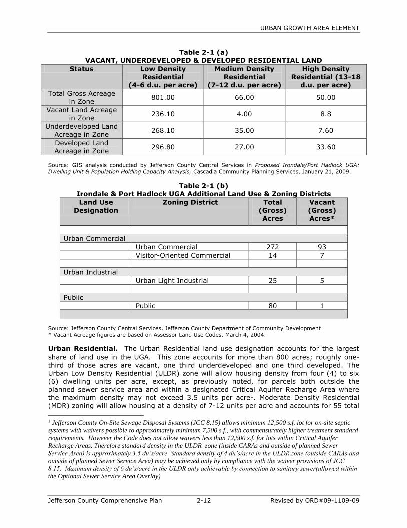
Table 2-1 (a) summarized the results of this disaggregation:
URBAN GROWTH AREA ELEMENT
Jefferson County Comprehensive Plan 2-12 Revised by ORD#09-1109-09
Table 2-1 (a)
VACANT, UNDERDEVELOPED & DEVELOPED RESIDENTIAL LAND
Status Low Density
Residential
(4-6 d.u. per acre)
Medium Density
Residential
(7-12 d.u. per acre)
High Density
Residential (13-18
d.u. per acre)
Total Gross Acreage
in Zone 801.00 66.00 50.00
Vacant Land Acreage
in Zone 236.10 4.00 8.8
Underdeveloped Land
Acreage in Zone 268.10 35.00 7.60
Developed Land
Acreage in Zone 296.80 27.00 33.60
Source: GIS analysis conducted by Jefferson County Central Services in Proposed Irondale/Port Hadlock UGA: Dwelling Unit & Population Holding Capacity Analysis, Cascadia Community Planning Services, January 21, 2009.
Table 2-1 (b)
Irondale & Port Hadlock UGA Additional Land Use & Zoning Districts
Land Use
Designation
Zoning District Total
(Gross)
Acres
Vacant
(Gross)
Acres*
Urban Commercial
Urban Commercial 272 93
Visitor-Oriented Commercial 14 7
Urban Industrial
Urban Light Industrial 25 5
Public
Public 80 1
Source: Jefferson County Central Services, Jefferson County Department of Community Development * Vacant Acreage figures are based on Assessor Land Use Codes. March 4, 2004.
Urban Residential. The Urban Residential land use designation accounts for the largest
share of land use in the UGA. This zone accounts for more than 800 acres; roughly one-
third of those acres are vacant, one third underdeveloped and one third developed. The
Urban Low Density Residential (ULDR) zone will allow housing density from four (4) to six
(6) dwelling units per acre, except, as previously noted, for parcels both outside the
planned sewer service area and within a designated Critical Aquifer Recharge Area where
the maximum density may not exceed 3.5 units per acre1. Moderate Density Residential
(MDR) zoning will allow housing at a density of 7-12 units per acre and accounts for 55 total
1 Jefferson County On-Site Sewage Disposal Systems (JCC 8.15) allows minimum 12,500 s.f. lot for on-site septic
systems with waivers possible to approximately minimum 7,500 s.f., with commensurately higher treatment standard
requirements. However the Code does not allow waivers less than 12,500 s.f. for lots within Critical Aquifer
Recharge Areas. Therefore standard density in the ULDR zone (inside CARAs and outside of planned Sewer
Service Area) is approximately 3.5 du’s/acre. Standard density of 4 du’s/acre in the ULDR zone (outside CARAs and
outside of planned Sewer Service Area) may be achieved only by compliance with the waiver provisions of JCC
8.15. Maximum density of 6 du’s/acre in the ULDR only achievable by connection to sanitary sewer(allowed within
the Optional Sewer Service Area Overlay)
URBAN GROWTH AREA ELEMENT
Jefferson County Comprehensive Plan 2-13 Revised by ORD#09-1109-09
acres within the UGA. The High Density Residential zone will allow housing at a density of
13-18 dwelling units per acre.
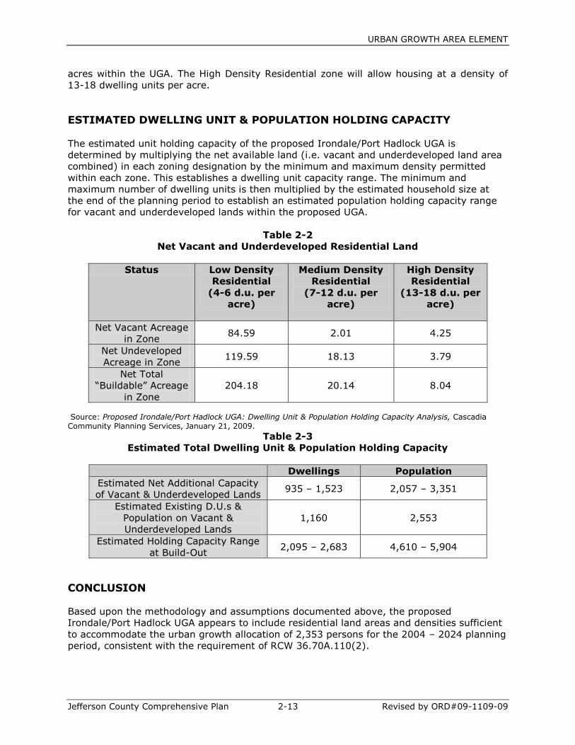
ESTIMATED DWELLING UNIT & POPULATION HOLDING CAPACITY
The estimated unit holding capacity of the proposed Irondale/Port Hadlock UGA is
determined by multiplying the net available land (i.e. vacant and underdeveloped land area
combined) in each zoning designation by the minimum and maximum density permitted
within each zone. This establishes a dwelling unit capacity range. The minimum and
maximum number of dwelling units is then multiplied by the estimated household size at
the end of the planning period to establish an estimated population holding capacity range
for vacant and underdeveloped lands within the proposed UGA.
Table 2-2
Net Vacant and Underdeveloped Residential Land
Status Low Density
Residential
(4-6 d.u. per
acre)
Medium Density
Residential
(7-12 d.u. per
acre)
High Density
Residential
(13-18 d.u. per
acre)
Net Vacant Acreage
in Zone 84.59 2.01 4.25
Net Undeveloped
Acreage in Zone 119.59 18.13 3.79
Net Total
“Buildable” Acreage
in Zone
204.18 20.14 8.04
Source: Proposed Irondale/Port Hadlock UGA: Dwelling Unit & Population Holding Capacity Analysis, Cascadia Community Planning Services, January 21, 2009.
Table 2-3
Estimated Total Dwelling Unit & Population Holding Capacity
Dwellings Population
Estimated Net Additional Capacity
of Vacant & Underdeveloped Lands 935 – 1,523 2,057 – 3,351
Estimated Existing D.U.s &
Population on Vacant &
Underdeveloped Lands
1,160 2,553
Estimated Holding Capacity Range
at Build-Out 2,095 – 2,683 4,610 – 5,904
CONCLUSION
Based upon the methodology and assumptions documented above, the proposed
Irondale/Port Hadlock UGA appears to include residential land areas and densities sufficient
to accommodate the urban growth allocation of 2,353 persons for the 2004 – 2024 planning
period, consistent with the requirement of RCW 36.70A.110(2).
URBAN GROWTH AREA ELEMENT
Jefferson County Comprehensive Plan 2-14 Revised by ORD#09-1109-09
If ultimate build-out were to occur uniformly at either the low or the high end of the
permissible density ranges in each residential zone, the population holding capacity would
range from a net deficit of -296 to a net surplus of +998 in relation to the adopted
population target of 4,906 for 2024. However, to assume either a uniformly “low-density” or
“high-density” build-out scenario is both unreasonable and unlikely. Instead, it is rational,
appropriate, and within the range of discretion afforded to localities planning under the GMA
to assume a more plausible density yield rate scenario of 75%. Such an assumption results
in an estimated capacity for 2,512 additional people occupying 1,142 dwelling units, and a
total population holding capacity of 5,065, some 159 persons over the 4,906 target. This
difference is insignificant in the context of an area-wide planning analysis.
Urban Commercial. Almost one-quarter of the total UGA is designated for commercial
land use. Several different commercial zoning districts may implement this land use
designation. The Urban Commercial (UC) zone is the largest constituting approximately 272
acres. It covers both the existing and planned future commercial development in the Port
Hadlock core area and along Rhody Drive from Ness” Corner to the “Dogbone” along SR 19.
The Visitor-Oriented Commercial (VOC) zone is applied to the tourism-oriented potential
development area around the Old Alcohol Plant.
Urban Industrial. Approximately 25 acres of land are designated as an Urban Light
Industrial (ULI) zone in the UGA—all but 5 acres of which are already in light industrial use.
These uses are located in the southwest corner of the UGA well buffered from the bulk of
the residential neighborhoods in the community.
Public Facilities. Public facilities (P) comprise 80 acres, including public park and open
space areas, the Library and Chimacum Creek Elementary School, the Jefferson County
Sheriff’s Office and Jail, Jefferson County Public Works Department Maintenance Yard, and
the PUD’s Sparling Well facility along Rhody Drive and the Kivley Well in Port Hadlock.
CAPITAL FACILITY PLANNING
Capital facility planning for Urban Growth Areas should be coordinated among the City,
County, and special purpose districts or other service providers who may be affected by the
advent of new urban growth and the need to plan for the provision of new urban levels of
service for public facilities such as sanitary sewer, potable water and public safety. For
affected non-County agencies—who may provide these services—to meet their own capital
facility plan goals, the County needs to ensure that it does not permit activity which would be
inconsistent with their future plans.
County-wide Planning Policy #3 identifies specific actions to be taken regarding joint planning
between the City of Port Townsend and Jefferson County that affects incorporated UGAs. The
need for continued joint planning with affected public service providers and local residents is a
critical component to UGA implementation. Of special importance will be the provision of urban
sanitary sewer services and the fiscal impacts of such a system on local residents. Potable
water service is already provided by the PUD #1.
Although it is an unincorporated UGA, it is sufficient in size and scope of urban densities and
intensities of uses to allow for potential incorporation—should local residents desire and
choose to do so at some point in the future. The County will continue to work with UGA
residents on the provision of adequate and financially feasible capital facilities.
URBAN GROWTH AREA ELEMENT
Jefferson County Comprehensive Plan 2-15 Revised by ORD#09-1109-09
The strategy of joint capital facility planning is to encourage jurisdictions and service
providers to enter into inter-local agreements to facilitate planning in areas of mutual
concern. The use of an inter-local agreement enables the affected local governments and
special purpose districts involved to work together to review, consider, and resolve issues of
mutual concern. The County, PUD #1, local residents and other affected agencies should
continue to work together towards the provision of adequate public facilities and services.
This section of this element is intended to address the provision of capital facilities and
utilities to the UGA. Level of Service (LOS) standards are established in the Capital
Facilities Element of the Plan as may be amended for the UGA by adoption of this element
and its appendices related to capital facility planning (i.e., sewer, stormwater and
transportation). The adopted level of service standards must be met by utility providers
within the UGA.
Many utilities and capital facilities are provided for in the UGA by non-county providers.
Many of these utilities are currently being provided at urban standards and do not require
amendments to the Capital Facilities or Utilities elements of the CP insofar as levels of
service are concerned. These include public water supply (being provided by the Jefferson
County PUD #1); electricity provided by Puget Sound Energy; cable television and
telecommunications provided by a range of carriers regulated by the Washington Utilities
and Transportation Commission (WUTC) and the Federal Communications Commission
(FCC), including cellular telephone service provided by AT&T Wireless Services and Verizon
Wireless and conventional telephone service provided by Qwest Communications.
These utility providers are controlled by laws and regulations, or franchise agreements.
Their requirement to meet levels of service is imbedded in these controls. For example, the
State Department of Health (DOH) requires water purveyors like the PUD to have 20 year
plans (revised every 6 years) which address service area demand, source of supply, LOS
(including fire flow), and a capital program for improvements to meet projected demand
into the future. Other utilities have similar requirements to demonstrate to the County and
others that they capacity to meet LOS will be in place to meet future demand.
In addition, many other public services and capital facilities are provided countywide by
Jefferson County at adopted levels of service that apply countywide and do not distinguish
between rural and urban areas. These facilities and services include:
Solid Waste;
Parks and Recreation;
County Maintenance Shop Facilities;
County Government Administrative Offices;
County Justice Facilities;
County Sheriff Facilities;
County Corrections Inmate Facilities;
Community Centers; and
Animal Control Shelter.
Levels of service and Six-Year and Twenty-Year Capital Facilities Plans for the public
facilities and services identified above are adopted in the Utilities and Capital Facilities
elements of the Comprehensive Plan.
Capital facilities needs associated with implementation of the UGA General Sewer Plan,
Transportation Plan and Stormwater Plan and the provision of public water by the PUD have

URBAN GROWTH AREA ELEMENT
Jefferson County Comprehensive Plan 2-16 Revised by ORD#09-1109-09
been included as part of the following section and are also adopted by reference in the
Capital Facilities Element of the Comprehensive Plan, as amended.
Sanitary Sewer Service
The UGA General Sewer Plan (GSP), adopted in this Comprehensive Plan, is required under
state law prior to development of a County sponsored sewer system. It is intended to be
general in nature. However, the Port Hadlock UGA Sewer Facility Plan, adopted as the GSP,
has been approved by the State Department of Health and State Department of Ecology as
an engineering plan. This goes much further than needed as a GSP and carries the sewer
facilities planning forward to the Preliminary Design phase.
See Appendix I, Port Hadlock UGA Sewer Facility Plan, September 2008, adopted herein as
the General Sewer Plan, for detailed information on Capital Facilities planning and a six-year
financing plan.
The adopted GSP provides a preliminary analysis of several alternatives for the development
of a public wastewater collection, treatment, and disposal system for the entire UGA over
the course of the 20-year planning period. See Appendix I for sewer service area
information and mapping.
Potable Water—Public Utility District #1 of Jefferson County (PUD)
The Irondale & Port Hadlock (UGA) water system serves the entire UGA and is part of a
network of interconnected public water supply systems that serve the Quimper Peninsula
operated by the PUD. The UGA system currently has 1,850 connections and projects a total
of 3,171 connections by 2025. The water system was purchased by the PUD from the City
of Port Townsend in 2002. The system contains two major wells: the Sparling Well and the
Kivley Well. The Sparling well and treatment plant currently serve as the primary water
supply source for the UGA, the Sparling well was originally drilled to augment the surface
water supply to the Irondale and Port Hadlock area from the City of Port Townsend water
supply line. The Kivley well was brought on line in 1972 to provide an additional supply.
The UGA water system has a single pressure zone. A one million gallon reinforced concrete
reservoir and a two million gallon steel reservoir are co-located on Somerville Road.
The system has five wells. There are two Sparling wells that are currently the primary
source of water for the UGA. The PUD is in the process of increasing the treatment capacity
of these wells to process 1500 gpm. The maximum flow rate allowed under the current
water right for the Sparling wells is 2,250 gpm. Three wells are located at the Kivley well
site. The instantaneous water right for the Kivley wells is 200 gpm. The PUD has requested
a new water right that would increase the Kivley well capacity to a minimum of 400 gpm.
Additionally, the PUD will be increasing the treatment capacity of the Sparling well by a
planned 500 gpm by 2006.
The existing water supply source meets the current demands on the UGA water system,
however the wells need to be brought up to their full water right. PUD studies indicate that
if the state DOH water system design standard of 466 gpd/ERU is used, the UGA water
system may only have enough water until the year 2015. The PUD indicates, however, that
based on an average daily demand of 350 gpd/ERU (actual PUD consumption records), the
PUD water system supply has adequate water rights sources for the 20 year planning

URBAN GROWTH AREA ELEMENT
Jefferson County Comprehensive Plan 2-17 Revised by ORD#09-1109-09
period. The PUD water system plans indicate that a water conservation plan, lower actual
UGA water usage (based on local consumption records) and planned system improvements
will result in enough water supply to meet the 20 year planning horizon. However, in the
best interest of a regional approach to water resource management, the PUD is also in
discussion with the City of Port Townsend about purchasing and treating additional
wholesale water for the PUD water system. This may provide for a more equitable and
better long-term solution to meeting projected demands on the resource.
Three improvement projects are identified in the PUD’s preliminary draft Capital Facilities
Plan for the UGA Water System based upon anticipated future demand as follows:
Sparling Well Improvements. In order to provide the water requirements for the
next 20 years the PUD is increasing the treatment capacity of the Sparling well by
500 gpm. Estimated Cost : $350,000. Funding Sources: System Development
Charges. Estimated Implementation Date: 2004-2005.
New Well. The PUD will be drilling a new production well to maximize its existing
water rights, to meet potential future demands, expand system flexibility, and
emergency response capacity. Estimated Cost : $375,000. Funding Sources: System
Development Charges. Estimated Implementation Date: 2005-2015.
Surface Water Sources. The PUD is working with the City of Port Townsend to
increase the amount of wholesale water purchased by the PUD from the City as
alternative to pursuing additional groundwater rights.
The current PUD #1 Quimper Water System Plan which, in part, serves the Irondale/Port
Hadlock Urban Growth Aras is hereby incorporated by reference into the Comprehensive
Plan. Subsequent changes to water system plans shall be consistent with the
Comprehensive Plan and be approved through legislative action of the Comprehensive Plan
amendment process, outlined in 18.45 JCC, prior to incorporation.
Stormwater Management
The UGA Stormwater Management Plan is a planning document that provides guidance to
minimize adverse effects of stormwater runoff on ground and surface water, including
aquatic resources and habitats, water quantity. It identifies water quality and quantity
problems associated with stormwater runoff that may adversely affect the environment and
community and provides recommendations for improvements and programs including a cost
analysis and an implementation schedule. The primary goal of the UGA Stormwater
Management Plan is to preserve and protect water quality and the hydraulic regime within
the UGA drainage basins and the receiving waters of Chimacum Creek and Port Townsend
Bay.
The Plan identifies specific structural and non-structural solutions to conveyance and water
quality problems within the UGA. Structural solutions include constructing detention and
infiltration ponds, pipes, and treatment facilities. Non-structural solutions include
stormwater management facility inspection and maintenance, public education and
outreach, water quality monitoring, and encouraging low impact development.
The Plan was developed in conformance with Jefferson County Comprehensive Plan Land
Use and Rural Element: Drainage, Flooding, Stormwater Management Issues and Polluted
Discharges. It meets the stormwater management recommendations of the Puget Sound
URBAN GROWTH AREA ELEMENT
Jefferson County Comprehensive Plan 2-18 Revised by ORD#09-1109-09
Water Quality Action Plan and the technical standards of the 2001 Washington Department
of Ecology Stormwater Management Manual for Western Washington (DOE Manual).
UGA designation will require the provision of drainage and stormwater management
facilities at an urban level of service standard in order to avoid significant stormwater run-
off and water quality impacts to Port Townsend Bay and Chimacum Creek and to ensure
that stormwater run-off does not contaminate groundwater resources.
The majority of the UGA does not have conveyance systems and will infiltrate stormwater
runoff on-site or within the sub-basin. Infiltration in the area is typically good, but varies
due to the groundwater table and soils. Most of the stormwater runoff in the UGA infiltrates
before reaching a conveyance system. There is a limited existing storm drainage collection
and conveyance system that consists of typical components such as catch basins, pipes,
open ditches, and, in the Port Hadlock Core, concrete curbs and gutters. There are two
outfalls to Port Townsend Bay in the UGA. They convey runoff collected by the Port Hadlock
Core storm sewer system and road drainage from Moore Street in Irondale.
Due to the relatively low level of development in the UGA, there is not a high volume of
stormwater currently being discharged into Port Townsend Bay. Thus, the overall impact on
water quality in the Bay associated with storm sewer outfalls appears to be limited. High
fecal coliform counts have been reported in Port Townsend Bay during the summer.
However, the UGA Stormwater Management Plan indicates that based on the levels, timing,
and location, they do not appear to be associated with runoff from the Port Hadlock storm
sewer system or Moore Street.
Nonetheless, the pollutant concentrations are sufficiently high that runoff treatment should
be provided, according to the recommendations made in the UGA Stormwater Management
Plan. In order to accomplish this goal, the County should coordinate with the Washington
Departments of Transportation and Fish and Wildlife and with private landowners to plan,
design, fund, and construct treatment facilities at both locations. Hydrologic modeling was
used in the UGA Stormwater Management Plan to develop planning level cost estimates for
replacing the outfalls and adding a treatment swale for both the Port Hadlock Core storm
sewer system and the Moore Street drainage system.
Future development within the UGA will be required to provide flow control (detention and
infiltration) and treatment per the Washington State Department of Ecology’s Stormwater
Technical Manual standards and to help pay their fair share for those portions of the storm
drainage system fronting their property. As additional development occurs within the UGA
limits, the amount of impervious surfaces will increase which will ultimately increase peak
surface-water runoff rates. To this end, the County intends to manage stormwater to
minimize contact with contaminants, mitigate the impacts of increased runoff due to
development within the UGA’s drainage areas, provide management of runoff from large
and small construction sites, and to preserve fish and wildlife habitat.
The analysis conducted for the UGA Stormwater Management Plan demonstrates that urban
development can occur without significant impacts from stormwater runoff provided that
there are adequate stormwater management facilities and a UGA Stormwater Management
Program.
The UGA Stormwater Management Plan includes policies intended to ensure that
development of the UGA does not cause significant adverse impacts related to stormwater
runoff. These policies include SWM Policy 1.7 Develop stable and equitable revenue sources
to fund a UGA Stormwater Management Program.

URBAN GROWTH AREA ELEMENT
Jefferson County Comprehensive Plan 2-19 Revised by ORD#09-1109-09
The UGA Stormwater Management Plan discusses alternative methods for funding capital
improvements and Stormwater Management Program activities. These alternatives include
grants and loans, developer fees, local improvement districts, and stormwater management
fees.
The UGA Stormwater Management Plan proposes two capital projects: a stormwater
treatment facility and replacement of an existing outfall. The treatment facility will cost
approximately $10,000; the cost to replace the outfall would be approximately $144,000.
(2004 Year Dollars)
The UGA Stormwater Management Plan proposes that parcels in the UGA Commercial,
Industrial, and Multi-Family Residential designations would pay a stormwater management
fee to fund inspection of stormwater management facilities in those areas. The inspection
program would cost approximately $10,000 per year.
The UGA Stormwater Management Plan proposes a UGA Stormwater Management Program
that would conduct public education, water quality monitoring, and stream gauging. The
annual SWM Program cost would be approximately $15,000.
Table 2-4 summarizes the projected UGA Stormwater Management Plan Capital
Improvements and Program Plan Expenditures and Funding.
Table 2-4
UGA Stormwater Management Plan
Capital Improvements and Funding: 2005 – 2024
Capital Improvements Projects 2004 Cost Year
Planned Funding Source / Notes
Port Hadlock Core Water Quality
Treatment Facility $10,000 2005 SWM Fee Port Hadlock Core
Port Hadlock Core Conveyance
Replacement $144,000 2011 SWM Fee Port Hadlock Core
Source: UGA Stormwater Management Plan May 2004
URBAN GROWTH AREA ELEMENT
Jefferson County Comprehensive Plan 2-20 Revised by ORD#09-1109-09
Transportation
Purpose
The purpose of the Transportation Plan portion of Chapter 2, the Irondale -Port Hadlock
Urban Growth Area (UGA) Element, is to amend and augment the Transportation and
Capital Facilities chapters of the Jefferson County Comprehensive Plan. This portion of the
UGA Element contains information and analysis relative to transportation both within and
adjacent to the UGA. The UGA Transportation Plan considers the impacts to transportation
due to UGA designation and forecasts the transportation needs and costs for a twenty -year
planning period. The UGA Transportation Plan describes the service standards desired for
the County's; transportation system within an Urban Growth Area, projects the impact that
the land use pattern contained in this Chapter will have on the transportation system, and
identifies the improvements necessary to meet future demand. The Jefferson County
Comprehensive Plan provides a framework of goals, - policies, and strategies necessary to
develop transportation facilities throughout the County. This portion of the UGA Plan further
defines these goals and policies for development inside the boundaries of the Urban Growth
Area at appropriate urban standards. The adopted Jefferson County Comprehensive Plan
portions relating to transportation include the majority of policy needed to accommodate
this UGA. This text is intended to be an amendment or supplement to the Comprehensive
Plan, which should be referenced for additional goals, policies and strategies not specifically
detailed in this document.
Introduction
The Washington State Growth Management Act (GMA) was passed in 1990 to encourage
planned, coordinated, growth for a more efficient use of the State's resources by reducing
sprawl. One of the ways in which the GMA seeks to accomplish these goals is to require
communities to adopt comprehensive growth plans that specify how new population growth
will be accommodated. By law, these plans must address the following areas:
transportation, capital facilities, utilities, land use, housing, and rural land.
With respect to transportation and transportation infrastructure, the GMA requires the
coordinated planning of regional transportation facilities and services. The GMA also
mandates that new development cannot occur unless infrastructure is in place to
accommodate the increased demand, or will be built concurrent with development.
In response to GMA requirements, the Tri-Area, an area encompassing the Chimacum,
Irondale and Port Hadlock communities, underwent a transportation planning and
forecasting study in 1999 known as the Tri- Area/Glen Cove Special Study. This study
analyzed three land use alternatives over a twenty year period and evaluated the impact on
Jefferson County's roadways. Building on the work that was completed for the Special
Study; the goal of this effort is to produce a Transportation Plan that will serve as a guide
for future transportation improvements that will aid in maintaining an adequate level of
transportation services and facilities in the Irondale — Port Hadlock Urban Growth Area
(UGA). This
Transportation Plan includes the following:
• Updated functional classification of county roads
• Updated traffic volume forecasts
• Intersection level of service analysis
• Potential transportation improvements
• Environmental Considerations
• Transportation improvement cost estimates
Through this planning process, the intent is to recognize when and where deficiencies will
occur and to provide solutions to capacity needs. Viable solutions may include additional
travel lanes, passing and pull-out lanes, turn pockets and signalization of currently un-

URBAN GROWTH AREA ELEMENT
Jefferson County Comprehensive Plan 2-21 Revised by ORD#09-1109-09
signaled intersections. The traffic forecasts used in this plan will provide for adequate urban
levels of public facilities and services in the Irondale - Port Hadlock Urban Growth Area.
Existing Conditions
Functional Classification
The roadways and highways in the Irondale -Port Hadlock UGA have been identified
according to functional classification. The functional classification system is based on a
road's ability to provide either mobility or access to adjacent land. There are five road
classes used to describe roads: principal arterials, minor arterials, major collectors, minor
collectors, and local roads. These classes are further defined by specifying whether the road
is part of an urban or rural roadway system. Table 1 provides a brief description of the
roadway functional classification system. The table is based on WSDOT publication,
Guidelines for Amending Urban Boundaries, Functional Classifications and Federal Aid
Systems.
As stated above, mobility is a key component in the functional classification system. When
reviewing a regional road system, it is important to note that arterials provide the most
mobility in the functional classification system. Arterials connect major destination points
such as cities and communities.
Principal arterials and minor arterials are distinguished by the importance of the destination,
and the priority given to mobility. Collectors serve as the link between arterials and local
streets. They gather (or collect) traffic from the smallest streets (local access) and direct
the traffic onto the arterial system. Local streets are those which provide direct access to
property and consequently provide more limited mobility. For local streets, mobility is not
considered as important as access to land uses.
Roadway spacing and design standards are directly related to the functional classification of
the road. In addition, right -of -way width requirements, lane widths, design speed and
other similar characteristics are all related to a roadway's functional classification. Figure 1
illustrates the updated functional classification of roadways in the UGA. It is noted that
SR19 has been designated as a Highway of Statewide Significance (HSS) and the functional
classification will change from a minor arterial to a principal arterial. This change reflects the
highway's increasing importance for the region and as an HSS route that links SRI 04 to
Port Townsend.
Traffic Volumes and Level of Service
Figure 2 illustrates existing average daily traffic '(ADT) volumes at several locations within
the study area. The most heavily traveled roadways within the UGA include SR19, SRI 16
and Irondale Road with existing traffic volumes peaking on SR19 at about 14,000 vehicles
per day (vpd). A very small section of SR19 from Irondale Road to Four - Corners' Road
carries a peak of 16,898 vpd. This is due to higher than average Peak Hour volumes along
this section of SR19. Given the relatively short period of time SR19 operates at this level
and the short length, of roadway that experiences this higher volume of traffic, the
operational counts for the entire length of SR19 from Irondale Road to SR -20 were used in
the level of service analysis of SR19 as this provides a more accurate picture of existing
operating conditions along SR19.

URBAN GROWTH AREA ELEMENT
Jefferson County Comprehensive Plan 2-22 Revised by ORD#09-1109-09
Table 1
Roadway Functional Classification Descriptions
Jefferson County
Functional
Class
Urban
(5,000 population or more)
Rural
Principal
Arterial
Serves regional major activity areas.
Carries all inter-urban and significant
intra-urban auto and transit trips.
Offers most mobility, least land
access.
Fully or partially controlled access.
Carries statewide or interstate
travel.
Serves most urban areas with
populations of at least 25,000.
Provides an integrated network.
Minor Arterial Interconnects and augments principal
arterials.
Distributed travel to areas smaller
than those associated with major
arterials.
Places more emphasis on land access
than principal arterials.
Links cities, larger towns and
major activity areas (e.g.
resorts).
Forms integrated network of
providing interregional and inter-
county service.
Spaced so that all developed
areas are within reasonable
distance of arterial highway.
Provide for high travel speed with
minimum interference to through
movement.
Major Collector Provides both land access and traffic
circulation within residential area.
Provides intra-community continuity
but doesn’t penetrate identifiable
neighborhoods.
Carries local bus routes.
Provides service to county seats
and major towns.
Links county seats and major
towns with nearby cities and
arterials
Serves the more important intra-
county travel
Minor Collector Collects traffic from local system and
channels it to arterials.
Provides both land access and traffic
circulation within residential
neighborhoods, commercial areas,
and industrial areas.
Collects traffic from local roads.
Provides for all developed areas
to be near collector road.
Provides service to smaller
communities.
Link locally important traffic
generators with their rural
hinterland.
Local Provides direct access to abutting
land and access to higher classified
cities.
Offers least mobility.
Usually contains no bus routes.
Through traffic deliberately
discouraged.
Serves primarily to provide
access to adjacent land.
Provides service to travel over
relatively short distances.
Level of Service (LOS) is a qualitative measure that combines the features of speed, safety,
travel time, comfort, convenience and traffic 'interruptions. Creation of the Irondale -Port
Hadlock UGA changes the UGA land use designation from rural to urban. One of the impacts
of this change is a concurrent change in the level of service standard for roadways in the
URBAN GROWTH AREA ELEMENT
Jefferson County Comprehensive Plan 2-23 Revised by ORD#09-1109-09
urban growth area. See Table 2 for roadway level of service definitions. The level of service
standard in Jefferson County for rural roadways is LOS C. The established level of service
standard for Jefferson County roadways in an urban area is LOS D or better. This difference
reflects the understanding that higher volumes of traffic are expected in urban areas
because of a concentration of economic activities. These higher levels of congestion are
considered acceptable during peak hours.
In 1998 the Washington State legislature passed House Bill 1487 that separated state
highways into two categories: Highways of Statewide Significance (HSS) and Regionally
Significant Highways (RS). This bill authorizes WSDOT to set level of service standards on
Highways of Statewide Significance. SR19 was recently designated as a HSS. The Level of
Service standards for SR19 are now set by WSDOT. WSDOT will accomplish this goal
through consultation with the Peninsula Regional Transportation Planning Organization
(PRTPO) which in turn will consult with Jefferson County. It should be noted that LOS
standards employed in this document for SR19 are consistent with PRTPO recommendations
but have not been established by WSDOT and are for County planning purposes.
SR19 currently operates at LOS D, an acceptable level for the Urban Growth Area. Outside
of the UGA boundary, SR19 continues to operate at LOS D. The PRTPO is currently looking
to designate SR19 as a Tourist Corridor. Jefferson County participates in the organization's
planning process and will follow the recommendations set forth by the PRTPO. The PRTPO
has identified various roadways on the Olympic Peninsula as Tourist Corridors to address
the issues created by fluctuations in traffic volumes during tourist seasons that cause some
roadways to drop below the adopted County standard in rural areas. 2.2 million tourists visit
the Port Townsend area every year with approximately 50% accessing the area by way of
SR19. As established by the PRTPO, Tourist Corridors are allowed to operate at LOS D,
similar to roadways in urban areas. Figure 3 shows current Level of Service designations for
roadways within the Irondale -Port Hadlock UGA.
Planned Roadway Improvements
Jefferson County's Six -Year Transportation Improvement Program (TIP) for 2004 to 2009
plans non- capacity related improvements ( channelization and pedestrian facilities) to the
portion of Chimacum Road from M.P. 0.41 to 0.98 (vicinity of the Jefferson County shop
southerly to the East Fork Chimacum Creek crossing). At this time, the Washington State
Department of Transportation ( WSDOT) has proposed only one signalization project for the
State - owned facilities of SRI and SRI 16 (Ness's Corner) from 2004 to 2009.
Current Deficiencies
Under existing conditions and urban standards, there are no current deficiencies in the UGA
road system. Intersection and toad segment Level of Service analysis was performed using
the Transportation Research Board's Highway Capacity Software (HCS). This software uses
such information as functional class, design hourly volume, free flow speed, road and
shoulder widths and number of lanes to determine level of service designations. HCS
provides an average LOS designation for the entire intersection, averaging the level of
service of both the major and minor legs of the intersection. The minor leg of an
intersection is defined as the intersecting roadway that is stop controlled, while the major
leg is the roadway which is free flowing. It should be noted that although overall
intersection analysis shows no current deficiencies, roadways that intersect SR19 develop
long queues and vehicle delays that approach unacceptable levels. This is caused by
relatively high volumes of traffic traveling along SR19 with few gaps to allow entering traffic
from intersecting roadways.
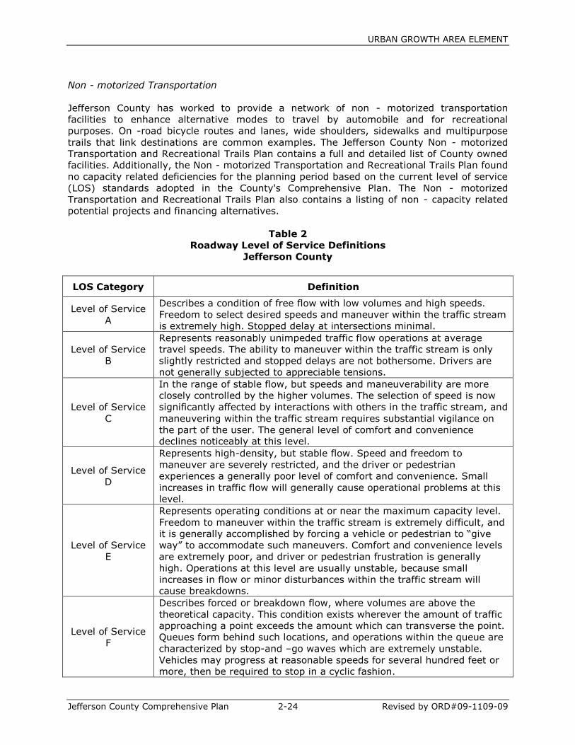
URBAN GROWTH AREA ELEMENT
Jefferson County Comprehensive Plan 2-24 Revised by ORD#09-1109-09
Non - motorized Transportation
Jefferson County has worked to provide a network of non - motorized transportation
facilities to enhance alternative modes to travel by automobile and for recreational
purposes. On -road bicycle routes and lanes, wide shoulders, sidewalks and multipurpose
trails that link destinations are common examples. The Jefferson County Non - motorized
Transportation and Recreational Trails Plan contains a full and detailed list of County owned
facilities. Additionally, the Non - motorized Transportation and Recreational Trails Plan found
no capacity related deficiencies for the planning period based on the current level of service
(LOS) standards adopted in the County's Comprehensive Plan. The Non - motorized
Transportation and Recreational Trails Plan also contains a listing of non - capacity related
potential projects and financing alternatives.
Table 2
Roadway Level of Service Definitions
Jefferson County
LOS Category Definition
Level of Service
A
Describes a condition of free flow with low volumes and high speeds.
Freedom to select desired speeds and maneuver within the traffic stream
is extremely high. Stopped delay at intersections minimal.
Level of Service
B
Represents reasonably unimpeded traffic flow operations at average
travel speeds. The ability to maneuver within the traffic stream is only
slightly restricted and stopped delays are not bothersome. Drivers are
not generally subjected to appreciable tensions.
Level of Service
C
In the range of stable flow, but speeds and maneuverability are more
closely controlled by the higher volumes. The selection of speed is now
significantly affected by interactions with others in the traffic stream, and
maneuvering within the traffic stream requires substantial vigilance on
the part of the user. The general level of comfort and convenience
declines noticeably at this level.
Level of Service
D
Represents high-density, but stable flow. Speed and freedom to
maneuver are severely restricted, and the driver or pedestrian
experiences a generally poor level of comfort and convenience. Small
increases in traffic flow will generally cause operational problems at this
level.
Level of Service
E
Represents operating conditions at or near the maximum capacity level.
Freedom to maneuver within the traffic stream is extremely difficult, and
it is generally accomplished by forcing a vehicle or pedestrian to “give
way” to accommodate such maneuvers. Comfort and convenience levels
are extremely poor, and driver or pedestrian frustration is generally
high. Operations at this level are usually unstable, because small
increases in flow or minor disturbances within the traffic stream will
cause breakdowns.
Level of Service
F
Describes forced or breakdown flow, where volumes are above the
theoretical capacity. This condition exists wherever the amount of traffic
approaching a point exceeds the amount which can transverse the point.
Queues form behind such locations, and operations within the queue are
characterized by stop-and –go waves which are extremely unstable.
Vehicles may progress at reasonable speeds for several hundred feet or
more, then be required to stop in a cyclic fashion.
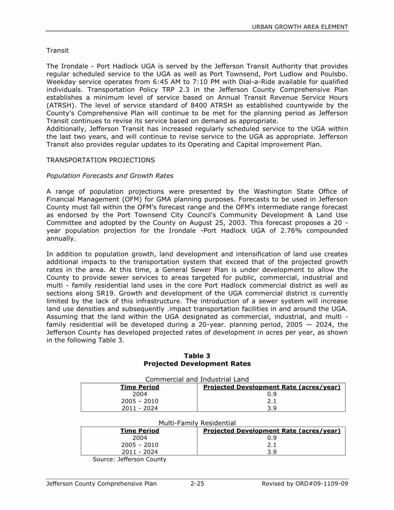
URBAN GROWTH AREA ELEMENT
Jefferson County Comprehensive Plan 2-25 Revised by ORD#09-1109-09
Transit
The Irondale - Port Hadlock UGA is served by the Jefferson Transit Authority that provides
regular scheduled service to the UGA as well as Port Townsend, Port Ludlow and Poulsbo.
Weekday service operates from 6:45 AM to 7:10 PM with Dial-a-Ride available for qualified
individuals. Transportation Policy TRP 2.3 in the Jefferson County Comprehensive Plan
establishes a minimum level of service based on Annual Transit Revenue Service Hours
(ATRSH). The level of service standard of 8400 ATRSH as established countywide by the
County's Comprehensive Plan will continue to be met for the planning period as Jefferson
Transit continues to revise its service based on demand as appropriate.
Additionally, Jefferson Transit has increased regularly scheduled service to the UGA within
the last two years, and will continue to revise service to the UGA as appropriate. Jefferson
Transit also provides regular updates to its Operating and Capital improvement Plan.
TRANSPORTATION PROJECTIONS
Population Forecasts and Growth Rates
A range of population projections were presented by the Washington State Office of
Financial Management (OFM) for GMA planning purposes. Forecasts to be used in Jefferson
County must fall within the OFM's forecast range and the OFM's intermediate range forecast
as endorsed by the Port Townsend City Council's Community Development & Land Use
Committee and adopted by the County on August 25, 2003. This forecast proposes a 20 -
year population projection for the Irondale -Port Hadlock UGA of 2.76% compounded
annually.
In addition to population growth, land development and intensification of land use creates
additional impacts to the transportation system that exceed that of the projected growth
rates in the area. At this time, a General Sewer Plan is under development to allow the
County to provide sewer services to areas targeted for public, commercial, industrial and
multi - family residential land uses in the core Port Hadlock commercial district as well as
sections along SR19. Growth and development of the UGA commercial district is currently
limited by the lack of this infrastructure. The introduction of a sewer system will increase
land use densities and subsequently .impact transportation facilities in and around the UGA.
Assuming that the land within the UGA designated as commercial, industrial, and multi -
family residential will be developed during a 20-year. planning period, 2005 — 2024, the
Jefferson County has developed projected rates of development in acres per year, as shown
in the following Table 3.
Table 3
Projected Development Rates
Commercial and Industrial Land Time Period
2004 2005 – 2010
2011 - 2024
Projected Development Rate (acres/year)
0.9 2.1
3.9
Multi-Family Residential Time Period
2004 2005 – 2010 2011 - 2024
Projected Development Rate (acres/year)
0.9 2.1 3.9
Source: Jefferson County
URBAN GROWTH AREA ELEMENT
Jefferson County Comprehensive Plan 2-26 Revised by ORD#09-1109-09
This assumes that the availability of a sanitary sewer system will affect the rates of
development. After the UGA designation is completed and prior to the development of a
sewer system, urban commercial and industrial development will be permitted, but only by
those developments that can be served by an on -site septic system. It is assumed that the
sanitary sewer system will be available by 2011 to designated areas. Using these
development rates, 12.6 acres of commercial and industrial land are estimated to be
developed during the 2005 -2010 planning period and 54.3 acres developed from 2011 to
2024. This growth scenario includes a 15% market reduction factor to account for land that
will be unavailable for development during this period.
Trip Generation
The impact of land development and intensification on the transportation system is
determined through the use of trip generation. Average daily traffic (ADT) rates are based
on averages published in the Institute of Transportation Engineer's (ITE) Trip Generation
6th Edition. Daily trip generation estimates for proposed land uses in the Irondale -Port
Hadlock area were based primarily on the square footage of floor space created by the
development and to a lesser extent total acreage of developed land. Average daily trip rates
for multi - family residential housing are based on average trips per resident. When using
trips per square footage, assumptions were made on the approximate dimensions of the
building in question. Each study in Trip Generation records the gross floor area of each type
of development and the average of these was used to determine an appropriate size. The
Jefferson County Unified Development
Code was also referred to as a functional standard from which to approximate acreage
required for development including parking lots, driveways and setbacks on the specific
sites of development. Table 4 summarizes the trip generation rates, site acreage and ADT
created by development in the UGA for the 2005 -2010 planning period.
Table 4
Average Daily Trip Rates for Various Land Uses
(2005 —2010)
2005-2010
Land Use Code Trip Rate Site
Acreage ADT
Multi-Family
Residential 220 35 residents 3.35/resident 1.6 117
Boat School 140 5.4 acres 38.88/acre 5.4 210
Credit Union 912 4,000 SF 265.2/1000* .5 1061
Auto Sales 841 25,000 SF 37.5/1000* 4.8 937
Building Supply 812 16,500 SF 39.7/1000* .9 655
13.2 2980
* Trip rates are per 1,000 square feet gross floor area
An estimated 2,980 additional daily trips will be created by the development of these sites.
The distribution of the vehicle trips onto the roadway system was calculated by percentage
characteristics of existing traffic conditions. The majority of trips were distributed along SRI
9, SRI 16, Irondale Rd, and Chimacum Rd, the key circulation routes throughout the area.
Distribution percentages were estimated based on the location within the UGA and the type
of land use planned for the site. Land available for development is generally situated along
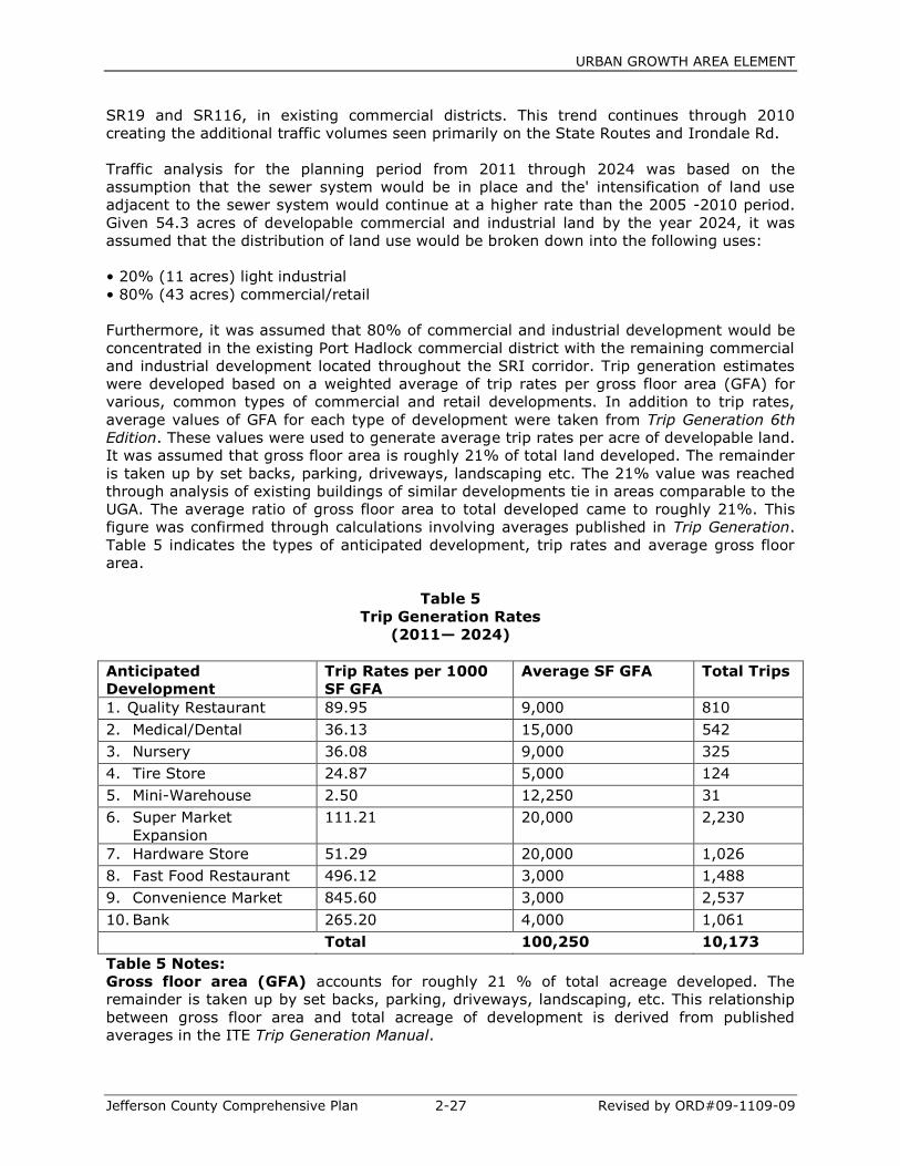
URBAN GROWTH AREA ELEMENT
Jefferson County Comprehensive Plan 2-27 Revised by ORD#09-1109-09
SR19 and SR116, in existing commercial districts. This trend continues through 2010
creating the additional traffic volumes seen primarily on the State Routes and Irondale Rd.
Traffic analysis for the planning period from 2011 through 2024 was based on the
assumption that the sewer system would be in place and the' intensification of land use
adjacent to the sewer system would continue at a higher rate than the 2005 -2010 period.
Given 54.3 acres of developable commercial and industrial land by the year 2024, it was
assumed that the distribution of land use would be broken down into the following uses:
• 20% (11 acres) light industrial
• 80% (43 acres) commercial/retail
Furthermore, it was assumed that 80% of commercial and industrial development would be
concentrated in the existing Port Hadlock commercial district with the remaining commercial
and industrial development located throughout the SRI corridor. Trip generation estimates
were developed based on a weighted average of trip rates per gross floor area (GFA) for
various, common types of commercial and retail developments. In addition to trip rates,
average values of GFA for each type of development were taken from Trip Generation 6th
Edition. These values were used to generate average trip rates per acre of developable land.
It was assumed that gross floor area is roughly 21% of total land developed. The remainder
is taken up by set backs, parking, driveways, landscaping etc. The 21% value was reached
through analysis of existing buildings of similar developments tie in areas comparable to the
UGA. The average ratio of gross floor area to total developed came to roughly 21%. This
figure was confirmed through calculations involving averages published in Trip Generation.
Table 5 indicates the types of anticipated development, trip rates and average gross floor
area.
Table 5
Trip Generation Rates
(2011— 2024)
Anticipated
Development
Trip Rates per 1000
SF GFA
Average SF GFA Total Trips
1. Quality Restaurant 89.95 9,000 810
2. Medical/Dental 36.13 15,000 542
3. Nursery 36.08 9,000 325
4. Tire Store 24.87 5,000 124
5. Mini-Warehouse 2.50 12,250 31
6. Super Market
Expansion
111.21 20,000 2,230
7. Hardware Store 51.29 20,000 1,026
8. Fast Food Restaurant 496.12 3,000 1,488
9. Convenience Market 845.60 3,000 2,537
10. Bank 265.20 4,000 1,061
Total 100,250 10,173
Table 5 Notes:
Gross floor area (GFA) accounts for roughly 21 % of total acreage developed. The
remainder is taken up by set backs, parking, driveways, landscaping, etc. This relationship
between gross floor area and total acreage of development is derived from published
averages in the ITE Trip Generation Manual.
URBAN GROWTH AREA ELEMENT
Jefferson County Comprehensive Plan 2-28 Revised by ORD#09-1109-09
Dividing the Average GFA by 0.21 results in the square feet required for the anticipated
development:
Developed Square Footage =100,250 SF / 0.21 = 477,381 SF
Dividing Developed Square Feet by 43,560 Square Feet/Acre yields acres required for the
anticipated development.
Total Acres of Development = 477,381 / 43,560 = 10.96 Acres
Dividing the Total Trips from the anticipated development by the developed acres producing
trips yields the Average Trip Generation per Acre.
Average Trip Generation per Developed Acre = 10,173 / 10.96 = 928 Trips /acre
Multiplying Average Trip Generation per Developed Acre by the total acres of commercial
designation (provided by DCD 3/8/2004) yields the projected total trips generated by
commercial development for the 2011 -2024 planning period.
Projected Commercial Trip Generation = 928 trips /acre x 43 Acres = 39,919 Trips
Using the data from Table 5 and the methodology described in the Table 5 Notes yields a
rate of 4-73 928 trips per acre for typical commercial uses. When applied to the 43 acres
proposed for commercial designation, this yields 39,919 average daily trips (ADT) generated
by commercial development for the 2011-2024 planning period. Using the rate of 52 trips
per acre for 11 acres of industrial designation (Trip Generation 6th Edition) yields 572 ADT.
A total of 40,491 ADT are estimated to be generated by future commercial and industrial
developments in the UGA and distributed onto the road system for the 14 year- period
2011-2024. Using the assumption that 80% of this total will occur near the existing Port
Hadlock commercial district, 32,393 ADT will be generated from commercial and light
industrial development in this area. The remaining 20% of commercial and industrial
development is assumed to occur throughout the SR19 corridor and create 8,098 ADT.
Multi - Family Residential
Multi-family residential development will be permitted within the UGA prior to the
development of the sewer system but is not expected to develop greatly due to the
restraints of on-site septic service. After the assumed availability of the sewer system by
2011, multi - family residential development will proceed at approximately 66 dwelling units
per year. This assumption is based on anticipated population growth and residential
capacities described in the Irondale & Port Hadlock UGA Preliminary Buildout Analysis
(Personius, 3/4/2004). Zoning within the UGA has been updated to reflect this development
with the addition of nearly 80 acres of multi - family residential land. This development
scenario produces approximately 911 dwelling units during the 2011 -2024 planning period.
Assuming an average of 2 persons per unit and 3.35 ADT per person, this creates 6104
trips. These trips typically begin near SR- 116, Chimacum Rd, and the Port Hadlock
Intersection. They are then distributed based on existing traffic patterns in the area.
The projected addition of this level of dense residential development will increase traffic and
congestion in areas near these dense developments. It will result in a proportionally
decreased population locating in the northern portion of the UGA and lower the traffic
impacts in this area. The transportation model for 2004 -2010 assumed a traffic growth rate
matching population growth at 2.76 %. This rate accounts for increases in vehicles on all
roadways within the UGA and is a figure to which trip generation is added. From 2011 -
2024, given that a large percentage of the population is being accounted for through Multi-
Family trip generation; it would be inaccurate to assume single- family traffic generation will
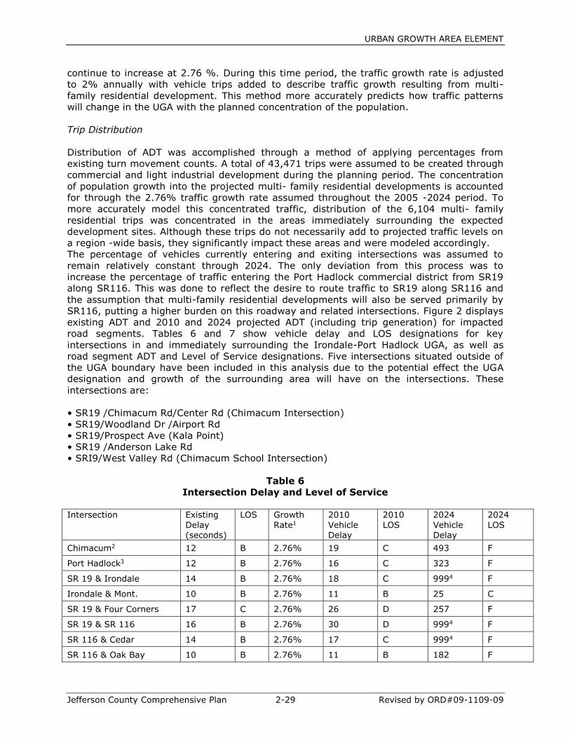
URBAN GROWTH AREA ELEMENT
Jefferson County Comprehensive Plan 2-29 Revised by ORD#09-1109-09
continue to increase at 2.76 %. During this time period, the traffic growth rate is adjusted
to 2% annually with vehicle trips added to describe traffic growth resulting from multi-
family residential development. This method more accurately predicts how traffic patterns
will change in the UGA with the planned concentration of the population.
Trip Distribution
Distribution of ADT was accomplished through a method of applying percentages from
existing turn movement counts. A total of 43,471 trips were assumed to be created through
commercial and light industrial development during the planning period. The concentration
of population growth into the projected multi- family residential developments is accounted
for through the 2.76% traffic growth rate assumed throughout the 2005 -2024 period. To
more accurately model this concentrated traffic, distribution of the 6,104 multi- family
residential trips was concentrated in the areas immediately surrounding the expected
development sites. Although these trips do not necessarily add to projected traffic levels on
a region -wide basis, they significantly impact these areas and were modeled accordingly.
The percentage of vehicles currently entering and exiting intersections was assumed to
remain relatively constant through 2024. The only deviation from this process was to
increase the percentage of traffic entering the Port Hadlock commercial district from SR19
along SR116. This was done to reflect the desire to route traffic to SR19 along SR116 and
the assumption that multi-family residential developments will also be served primarily by
SR116, putting a higher burden on this roadway and related intersections. Figure 2 displays
existing ADT and 2010 and 2024 projected ADT (including trip generation) for impacted
road segments. Tables 6 and 7 show vehicle delay and LOS designations for key
intersections in and immediately surrounding the Irondale-Port Hadlock UGA, as well as
road segment ADT and Level of Service designations. Five intersections situated outside of
the UGA boundary have been included in this analysis due to the potential effect the UGA
designation and growth of the surrounding area will have on the intersections. These
intersections are:
• SR19 /Chimacum Rd/Center Rd (Chimacum Intersection)
• SR19/Woodland Dr /Airport Rd
• SR19/Prospect Ave (Kala Point)
• SR19 /Anderson Lake Rd
• SRI9/West Valley Rd (Chimacum School Intersection)
Table 6
Intersection Delay and Level of Service
Intersection Existing
Delay (seconds)
LOS Growth Rate1
2010 Vehicle Delay
2010 LOS
2024 Vehicle Delay
2024 LOS
Chimacum2 12 B 2.76% 19 C 493 F
Port Hadlock3 12 B 2.76% 16 C 323 F
SR 19 & Irondale 14 B 2.76% 18 C 9994 F
Irondale & Mont. 10 B 2.76% 11 B 25 C
SR 19 & Four Corners 17 C 2.76% 26 D 257 F
SR 19 & SR 116 16 B 2.76% 30 D 9994 F
SR 116 & Cedar 14 B 2.76% 17 C 9994 F
SR 116 & Oak Bay 10 B 2.76% 11 B 182 F

URBAN GROWTH AREA ELEMENT
Jefferson County Comprehensive Plan 2-30 Revised by ORD#09-1109-09
SR 19 & Woodland 14 B 2.76% 18 C 78 F
SR & Prospect 16 C 2.76% 19 C 424 F
SR 19 & Anderson Lk 18 C 2.76% 28 C 242 F
SR 19 & West Valley 18 C 2.76% 33 D 9994 F 1 The actual growth in traffic volumes is due to a base population growth rate of 2.76 percent per year and impacts to traffic from new development in the Hadlock central core area and along SR19. The 2011-2024 period assumes a rate of 2.00%. 2 SR 19 and Chimacum/Center Road intersection
3 SR 116 and Irondale/Chimacum Road intersection
4 Maximum values report by Highway Capacity Software
Table 7
Road Segment Average Daily Trips and Level of Service
Existing 2010 Forecast
2024 Forecast
Road Segment From To ADT LOS Growth Rate *
ADT LOS ADT LOS
SR 19 North of Irondale SR 20 14,000 D 2.76% 18,437 E 36,574 F
SR 19 North of SR 116 Irondale 12,470 D 2.76% 16,681 E 33,050 F
SR 19 Center Road SR 116 9,878 D 2.76% 13,075 D 26,960 F
Irondale Road SR 19 Montgomery 4,248 C 2.76% 5,002 C 14,518 D
Irondale Road Montgomery Hadlock Intersection 4,276 C 2.76% 5,035 C 15,594 D
SR 116 Irondale Rd Oak Bay Rd 5,550 C 2.76% 6,476 C 21,144 E
SR 116 SR 19 Chimacum/Irondale Rd 6,300 C 2.76% 8,049 C 20,434 E
Cedar Ave SR 116 Montgomery 1,937 B 2.76% 2,281 B 5,758 C
Chimacum Rd SR 116 SR 19 5,859 C 2.76% 6,899 C 19,164 E
* The actual growth in traffic volumes is due to a base population growth rate of 2.76 percent per year and impacts to traffic from new development in the Hadlock central core area and along SR 19. The 2011-2024 period assumes a rate of 2.00%
Deficiencies Under existing conditions, mobility on SR19 is adequate. There are several unsignalized
intersections accessing SR19 in the Irondale, Port Hadlock and Chimacum areas. At this
time, these roadways typically experience moderate but acceptable delays as vehicles wait
for gaps in traffic on SR19. As volumes build, these gaps in traffic will decrease, creating
greater delay on the minor legs of intersections. Long vehicle queues will develop and safety
may be compromised since vehicles will not have enough time to merge onto SR19. To
maintain mobility on SR19, a minimum number of interruptions to traffic flow (traffic
signals) should be pursued. The most appropriate way to avoid excessive signalization is to
minimize the number of locations of traffic access onto SR19 as well as control turn
movements onto SR19. The intersection of SR19 and SR116 (Ness's Corner) is the most
obvious choice for signalization in the near future. If signalized, traffic could be redirected to
this intersection by way of further road improvements to facilitate traffic circulation and
mobility. The benefits of this would include the following:
• Limited access to SR19 would increase the mobility along SR19
• Minimize impacts of growth to the neighborhoods along Irondale Rd.
URBAN GROWTH AREA ELEMENT
Jefferson County Comprehensive Plan 2-31 Revised by ORD#09-1109-09
• Greater control of turn movements onto SR19
• Reduce existing delays on the minor leg of the intersection
• Provide safe, efficient route through the UGA for freight and other commercial traffic
It is likely that signalization of the SR19/SR116 intersection would create sufficient gaps in
traffic along SR19 to allow safer, more comfortable turn movements onto SR19. Although
this intersection will is projected to operate at LOS D by 2010, the minor leg control delay
on SRI 16 approaches 62 seconds per vehicle and operates at LOS F. To reduce this delay,
relieve congestion and enhance safety, this intersection should be signalized within the next
six years.
Several intersections experience similar problems to 'those of the SR19 /SR116 intersection.
SR19 typically experiences acceptable flow while intersecting roadways begin to develop
long delays as vehicles attempt to turn onto SR19. At intersections with lower turn
movements such as SR19 and Woodland Dr, SR19 and Prospect Ave, SR19 and Anderson
Lake Rd, minor leg delay and LOS deficiency can be alleviated through the addition of flared
-right turn pockets that allow right-turning vehicles space to move around left - turning
vehicles. While these intersections are located outside of the UGA, their operational status is
dependent on the operational characteristics of SR19 inside of the UGA.
As such, they are included in the transportation analysis for the UGA. Preliminary planning
analysis of these improvements and the potential gaps created by signalization at SR19 and
SRI 16 show slight increases in level of service through 2024.
If growth and development continues as planned over the next twenty years, further
improvements to the road system will be required to maintain adopted Level of Service
standards. Signalization of additional intersections will be required to handle significantly
increased volumes projected to occur by 2024. In addition, capacity improvements will be
required on SR19 and SRI 16 to handle expected higher volumes of traffic.
Based on projected volumes, signal improvements as shown in Table 8 will be required at
the following intersections by 2024:
Inside the UGA:
Hadlock Intersection
SRI and Irondale Rd
SRI 16 and Cedar Ave
Outside the UGA:
Chimacum Intersection
SR19 and West Valley Rd.
The suggested improvements discussed below are based solely on future Level of Service
projections and engineering assumptions and judgment. It is assumed these improvements
will not be required during the 2005 -2010 planning period given estimated LOS projections.
At this time, only estimates have been made as to the satisfaction of State recognized
Signal Warrants. Satisfaction is based on the following warrants:
• Warrant 1 - Eight Hour Vehicular Volume
• Warrant 2 - Four Hour Vehicular Volume
• Warrant 6 - Coordinated Signal System
• Warrant 8 - Roadway Network
The Washington State Department of Transportation recognizes the above warrants as listed
in the Manual on Uniform Traffic Control Devices (MUTCD), Chapter 4C. These locations
should be monitored and an engineering study of traffic conditions at each location should

URBAN GROWTH AREA ELEMENT
Jefferson County Comprehensive Plan 2-32 Revised by ORD#09-1109-09
be performed to determine when installation of a traffic control signal is justified. The timing
of intersection improvements along SR19 must consider a balance between providing
mobility along the arterial and accessibility from the intersecting roadways.
Port Hadlock Intersection (Inside UGA). The Port Hadlock intersection is currently an all
way stop controlled intersection in the heart of the Port Hadlock commercial district. At
current traffic volumes, this intersection functions extremely well as a stop-controlled
intersection. As volumes build toward projected 2024 levels, service at this intersection
begins to break down and signalization will be required to handle the denser, urban
conditions that are expected as growth occurs in the core Port Hadlock commercial district.
SR19 and Irondale Rd (Inside UGA). Conditions at SR19 and Irondale Rd will become
similar to that of the intersection of SR19 and SRI 16. Possible widening of SR19 through
the UGA to four lanes of traffic would further increase the difficulty and danger of vehicles
turning onto SR19. Signalization of this intersection will be required to handle increased
volumes on both legs.
Due to close proximity, it is possible that a signal at both SR19/1rondale Rd and SR19/Four-
Corners Rd (just outside of the UGA) could place unfavorable restrictions on the mobility of
SR19. Signal Density on
SR19, as described in the Transportation Research Board's (TCB) Highway Capacity Manual
(HCM), is borderline to recommended levels with two signals at these intersections. To
minimize the number of stops along SR19 and reduce financial costs, it is recommended
that an alternate solution to signalization of both intersections be studied.
SR116 and Cedar Ave (Inside UGA). Development along SRI 16 and in the Port Hadlock
commercial district will increase the importance of SRI 16 as a major collector of SR19. Both
legs of this intersection will experience increased volumes and an unacceptable level of
service. It is desired and anticipated that SR116 will continue to be the primary route to
connect the Port Hadlock core and SR19. Signalization of this intersection will facilitate
safety and access to and from SR116 and Cedar Ave. Prior to signalization the addition of
right turn vehicle storage on the southbound leg of Cedar Ave should be considered. This
improvement will likely increase the functional capacity of this intersection and maintain an
acceptable, urban level of service until signal warrants are met.
Chimacum Intersection (Outside UGA). Increasing volumes at this all way stop
controlled intersection will require signalization to maintain mobility on SR19 and handle
increasing volumes along Chimacum Rd /Center Rd due to growth and development
expected in the Port Hadlock commercial core.
SR19 and West Valley Rd (Outside UGA). Currently this intersection has both left and
right turn lanes with adequate storage in each. However, this intersection is the principal
access to Chimacum School and at peak times experiences long delays due to traffic to and
from the school including numerous school buses. Undesirable delays and safety concerns
may dictate signalization of this intersection.
SR19 Roadway Level of Service capacity for SRI as a two-lane highway with turn lane
median is a maximum of 14,300 ADT for LOS threshold "D ". Figure 2 shows that existing
conditions approach this threshold. The 2024 volumes for all segments within the UGA are
projected to exceed capacity and result in the roadway operating at LOS F. (See Figure 2
and Figure 3.) Capacity improvements will have to be completed to increase the level of
service of SR19 to acceptable standards both inside and outside of the UGA. Typically this
involves the addition of travel lanes in each direction including illumination, stormwater
mitigation, right-of-way acquisition, and wetland reparations. Capacity (mobility)
URBAN GROWTH AREA ELEMENT
Jefferson County Comprehensive Plan 2-33 Revised by ORD#09-1109-09
improvements for SR 19 are included in the Washington State Highway System Plan: 2003 -
2022, Appendix K, page 24.
SR116 Roadway Level of Service capacity for SR116 as a two-lane highway is a maximum
of 12,900 ADT for LOS threshold "D". The 2024 volumes for the segments within the UGA
are projected to exceed this threshold and result in the roadway operating at LOS E.
Capacity improvements will have to be completed to increase the level of service of SR116
to acceptable standards. Typically this would involve widening the roadway through the
addition of a two-way left turn lane, curb, gutter & sidewalk, illumination, stormwater
mitigation, right -of -way acquisition, and wetland reparations.
Growth and development in the Irondale-Port Hadlock UGA will have some impacts to the
transportation system. A significant portion of that impact will occur on SR19 and SR116.
The Washington State Department of Transportation (WSDOT) has jurisdiction over these
roads. Continued and increased intergovernmental coordination between WSDOT and
Jefferson County will become more important to coordinate transportation improvements
within and adjacent to the Irondale -Port Hadlock UGA. The coordination will be necessary
to accommodate future population growth and development while mitigating the resulting
impacts and increased congestion from both within and outside the UGA.
ENVIRONMENTAL CONSIDERATIONS
Human activity can have a major impact on vegetation, wildlife, and water resources. Land
use policies seek to protect the environment, conserve our resources, and permit future
development only in areas that can support it without significant adverse impact. Protecting
the natural environment, including environmentally sensitive lands in developed areas of the
UGA requires the following:
• Preserving ecological balance
• Maintaining or improving air and water quality
• Retaining open space in its natural state
• Protecting groundwater from pollution
• Providing public access to and setbacks from environmentally sensitive land
New developments within the Irondale-Port Hadlock UGA will be required to minimize and
mitigate adverse environmental impacts. The UGA designation will have little impact on the
transportation system. This is not to say that there will not transportation issues or needs
associated with growth in and adjacent to the UGA, only that designation as a UGA is not
the overriding factor. The foremost effect the UGA will have on transportation will be when
the availability of sewers to the commercial/industrial/multi-family zoned designated areas
allows them to be developed more intensely and generate higher traffic volumes. The
analysis shows that a total of about 43,471 additional trips per day would be generated
during the twenty-year planning period and distributed onto the road system.
Transportation decisions are not, and should not be, exempt from environmental review.
Impacts to the natural and built environment need to be taken into consideration before any
major transportation improvement projects are made. Most transportation projects are
subject to state and federal environmental regulations as well as any local environmental
laws that apply. County road projects routinely follow NEPA/SEPA regulations unless they
are specifically exempted.
URBAN GROWTH AREA ELEMENT
Jefferson County Comprehensive Plan 2-34 Revised by ORD#09-1109-09
CAPITAL FACILITIES
The concurrency requirement in the Growth Management Act (GMA) states that "...public
facilities and services ... shall be adequate to serve the development at the time the
development is available for occupancy and use without decreasing current service levels
below locally established minimum standards." [GMA, Section 2, Planning Goals (12)] This
means that public facilities and services must be in place to serve the proposed use at the
level of service (LOS) set by the community. Some improvements may be completed in
whole or in part, by new development within the UGA. A program should be established to
complete construction of these projects in the succeeding time period.
Under current State law and Jefferson' County Comprehensive Plan policies, highways
owned by the State (State Routes) are not bound by the constraints of concurrency
requirements. In these instances, the timing and prioritization of improvements is ultimately
that of the Washington State Department of Transportation. Typically, WSDOT coordinates
with the local jurisdiction and regional transportation planning organization to maintain a
balance between the free -flow movement of people and goods, and the needs of the local
community.
Total transportation facility improvements for the complete 20 -year planning period (2005 -
2024) are summarized in Table 8. These improvements are directly or indirectly associated
with development and growth in the Irondale - Port Hadlock UGA. WSDOT has classified
SR19 as a principal arterial and Highway of Statewide Significance (HSS). This change will
likely qualify the roadway for more state and federal funding to bring it into compliance with
standards. Transportation facility improvements for the six -year planning period, 2005 -
2010, are included in Table 8. This estimate includes the Chimacum Rd improvements
proposed in the Jefferson County Six –Year Transportation Improvement Program (TIP).
Proposed improvements to this roadway include:
• Intersection realignments and improvements
• .57 miles of reconstruction
Proposed funding sources for this project include $500,000 in Rural Arterial Program (RAP)
funds and $217,000 in local funding.
The SR19/SR116 intersection (Ness's Corner) is a state owned facility. Improvements will
likely be funded by a combination of State and local funds. This intersection currently
satisfies State warrants for signalization but is well down on the priority list of proposed
projects to receive funding. Project funding options, including the application of local
funding to this project, should be considered to insure this project is completed at an
appropriate time. Proposed improvements include reconstruction and signalization of this
intersection to urban standards.
Table 8 also shows transportation facility improvements associated with new development
that should require completion or participation by adjacent property owners either through
private construction or through a Road Improvement District. Constructing necessary
transportation improvements to serve new developments should be required by County
Comprehensive Plan policies and Unified Development Code standards to ensure
completion. All costs shown in Table 8 include an assumed annual inflation rate of 2.2 %.
URBAN GROWTH AREA ELEMENT
Jefferson County Comprehensive Plan 2-35 Revised by ORD#09-1109-09
CONCLUSION
The analysis in this portion of Chapter 2 shows that overall; impacts from the development
of the UGA on the transportation system and potential transportation needs in the UGA and
adjacent areas are manageable. While the UGA designation may impact transportation by
increasing demand earlier than it would have otherwise occurred, the impacts would still be
likely to occur without UGA designation. The primary concern has been and continues to be
the SR19 Corridor and how future adjacent land use will impact its ability to carry through-
traffic.
While this analysis considers the overall growth of the UGA and is based on the land use
assumptions provided and known at this time, further analysis of the transportation system
should be undertaken when initial land use regulations are in place in order to determine
impacts to individual neighborhoods within the UGA. Further analysis should look at impacts
to road segments based on zoning designations in a more localized manner within the UGA.
This could lead to changes in land use, to transportation standards, or transportation
improvements.

URBAN GROWTH AREA ELEMENT
Jefferson County Comprehensive Plan 2-36 Revised by ORD#09-1109-09
Table 2-5
UGA Transportation Improvements (2005 – 2024)
(Costs estimated for 2004, and adjusted annually at 2.2% inflation)
Non-Capacity Projects 2005 – 2010
Route Route Description From To 2005-2010 Funding Funding
I.D. Name M.P. M.P. Cost Source(s) Status
Inside UGA
932507 Chimacum Rd. County Shop to W. F. Chimacum Crk. 0.41 0.98 $ 720,000 RAP / Local Proposed
SR19/116 SR19 @ SR116 Signalization - Reconstruct to Urban Stds. 10.71 10.71 $ 334,484 WSDOT/Local Proposed
Total Non-Capacity Projects 2005 – 2010 $ 1,054,484
Non-Capacity Projects 2011 – 2024
Route Route Description From To 2011-2024 Funding Funding
I.D. Name M.P. M.P. Cost Source(s) Status
Inside UGA
SR116 Port Hadlock Intersection Signalization (2017-18) $ 434,297 WSDOT/Local Unfunded
SR19 SR19. @ Irondale Rd. Signalization (2018-19) $ 346,500 WSDOT/Local Unfunded
SR116 SR116. @ Cedar Ave. Signalization (2018-19) $ 346,500 WSDOT/Local Unfunded
Outside UGA
SR19 SR19. @ Prospect Ave. Intersection Improvements (2011-13) $ 243,270 WSDOT/Local Unfunded
SR19 SR19 @ Anderson Lk. Rd. Intersection Improvements (2014-15) $ 254,091 WSDOT/Local Unfunded
SR19 SR19 @ Woodland Dr. Intersection Improvements (2014-15) $ 254,091 WSDOT/Local Unfunded
SR19 SR19 @ West Valley Rd. Signalization (2020-21) $ 361,914 WSDOT/Local Unfunded
SR19 Chimacum Intersection Signalization (2020-21) $ 445,160 WSDOT/Local Unfunded
Total Non-Capacity Projects 2011 – 2024 $ 2,685,823
Capacity Projects 2005 - 2024
Route Route Description From To 2005-2024 Funding Funding
I.D. Name M.P. M.P. Cost Source(s) Status
Inside UGA
SR19 SR19 Widen to Four Lanes (2020-22) 10.50 11.75 $ 5,978,800 WSDOT Unfunded
SR116 SR116 Widen to Three Lanes (TWLTL) (2020-22) 0.0 1.11 $ 2,408,700 WSDOT Unfunded
Outside UGA
SR19 SR19 Widen to Four Lanes (2020-22) 9.00 10.50 $ 7,174,600 WSDOT Unfunded
SR19 SR19 Widen to Four Lanes (2020-22) 11.75 14.16 $ 11,527,100 WSDOT Unfunded
Total Capacity Projects 2005 - 2024 $27,089,200
Private Developer Projects 2005 – 2024
Route Route Description From To 2005-2024 Funding Funding
I.D. Name M.P. M.P. Cost Source(s) Status
Inside UGA
932507 Chimacum Rd. Reconstruction to Urban Stds. 0.41 0.64 $ 138,600 Developer Unfunded
SR116 SR116 Reconstruction to Urban Stds. 0.12 0.47 $ 210,000 Developer Unfunded
SR116 SR116 Reconstruction to Urban Stds. .47 1.11 $ 164,000 Developer Unfunded
658909 D Street Reconstruction to Urban Stds. 0.00 0.10 $ 72,722 Developer Unfunded
634509 Hunt Rd Reconstruction to Urban Srds 0.00 0.20 $ 115,000 Developer Unfunded
933507 Irondale Rd Reconstruction to Urban Stds. 1.56 1.79 $ 284,545 Developer Unfunded
Total Private Developer Projects 2005 - 2024 $ 984,867
Total All Projects 2005 - 2024 $ 31,814,374
URBAN GROWTH AREA ELEMENT
Jefferson County Comprehensive Plan 2-37 Revised by ORD#09-1109-09
GOALS AND POLICIES
As in all elements of this Plan, the goals are general statements while policies are more
specific. Goals state the general growth management intentions of the County while the
policies are the specific guidelines. Strategies address implementation of goals and policies
through specific projects and programs.
The goals and policies of the Urban Growth Area element provide direction for the
development of Jefferson County’s Irondale & Port Hadlock Unincorporated UGA. They
outline specific criteria for urban development, incorporating issues and opportunities
identified by County residents in the public UGA planning process.
Urban Growth Area policies provide the basis for subsequent land use and capital facility
planning and implementation in the UGA. This section also provides guidance for the UGA-
specific development regulations contained in Appendix D of the Unified Development Code
(Irondale & Port Hadlock UGA Implementing Regulations), now codified in Chapter
18.18.JCC.
URBAN GROWTH AREA
GOAL:
UGA-G 1.0 Encourage a balance of commercial and industrial uses for urban-
scale and regional-scale economic activities within Urban Growth
Areas (UGAs).
UGA-G 1.1 Provide for the orderly development of urban land uses in urban
growth areas consistent with the provision of adequate and feasible
urban levels of public facilities and services
POLICIES:
UGA-P 1.1 Encourage and facilitate urban regional-scale economic activities in
unincorporated UGAs which provide for countywide goods, services, and
employment opportunities.
UGA-P 1.2 New urban growth should be channeled into areas that are already
characterized by existing urban growth or adjacent to areas characterized by
urban growth. Within the confines of the GMA, urban levels of services for
capital facilities should be scaled to the needs of urban growth areas and the
ability of businesses, homeowners, workers and the public to finance them.
UGA-P 1.3 Future infrastructure improvements must be appropriate for the planned
development densities in the County. UGAs will be implemented where urban
public facilities and services are necessary to support higher density
residential and/or commercial growth. The level of urban infrastructure must
serve the needs of the public, protect the environment and be affordable.

URBAN GROWTH AREA ELEMENT
Jefferson County Comprehensive Plan 2-38 Revised by ORD#09-1109-09
UGA-P 1.4 Encourage growth in the Irondale & Port Hadlock UGA commensurate with the
appropriate level of urban public facility and service capacities consistent with
adopted plans and interlocal agreements.
(a) Manage development and redevelopment through revisions to the Unified
Development Code (UDC) and the application of UGA land use
designations and zoning classifications that can be implemented consistent
with the adopted levels of service for urban public facilities and services.
(b) Provide urban governmental services at urban levels of services (see Capital
Facilities Element, Policy CFP 1.1, and UGA Element, Policy UGA-P 2.8, for
list of urban public facilities and their adopted levels of service) prior to or
concurrent with development.
(c) The County shall coordinate with the respective purveyor, special district,
agency or other entities delivering, or who are anticipated to deliver, urban
public facilities and services to ensure that growth and development are
timed, phased, and consistent with the provision of adequate urban level
facilities and services.
(d) Where the County is not the urban public facility or service provider for the
unincorporated UGA, the County may adopt an Interlocal Agreement with
the appropriate service provider, where necessary, to ensure the provision
of adequate levels of service for urban public facilities and services. Such
agreements, when utilized, shall include the level of urban public facilities
and services.
UGA-P 1.5 Encourage growth in UGAs that will be served by a combination of both existing
urban public facilities and services and any additional needed urban public
facilities and services that are provided by either public or private sources.
Development within the unincorporated UGA shall be consistent with the
densities and intensities of use, bulk and dimensional and other development
standards found within this element and the adopted urban public facilities
levels of service.
UGA-P 1.6 The Irondale & Port Hadlock UGA has a limited amount of undeveloped
commercial parcels suitable for attracting and accommodating regional
commercial development. To enhance the potential for commercial
redevelopment opportunities in the UGA, parcels currently utilized for and
designated as Urban Residential on the UGA Zoning Map (Figure 2-1) may be
designated Urban Commercial, provided that those parcels meet all of the
following criteria:
1) The parcel rezone request is presented and approved through the annual
comprehensive plan amendment process specified in 18.45, JCC.
2) The parcel rezone request is consistent and compatible with the
Comprehensive Plan and future needs, documented through a commercial
land needs analysis.
Any change from Urban Residential to Urban Commercial shall be reflected on
both the Comprehensive Plan Zoning Map and Jefferson County Zoning Map, as
they are the same.
UGA-P 1.7 Amendments to the UGA Zoning Map (Figure 2-1) and implementing UGA
regulations in Appendix D of the UGA shall be subject to the amendment
requirements of UDC Section 18.45, JCC.
URBAN GROWTH AREA ELEMENT
Jefferson County Comprehensive Plan 2-39 Revised by ORD#09-1109-09
UGA-P 1.8 The County should provide for on-going review and evaluation of the Irondale &
Port Hadlock Unincorporated UGA to monitor the rate of development, land
supply and availability, market conditions, infrastructure implementation and
costs in order to identify constraints to growth in the UGA and recommend
corrective actions, where appropriate.
URBAN LEVEL CAPITAL FACILITIES
GOAL:
UGA-G 2.0 Limit the establishment or expansion of urban-level development and
infrastructure to Urban Growth Areas and Master Planned Resorts.
POLICIES:
UGA-P 2.1 Ensure that expansion of urban infrastructure occurs in coordination with
designated land uses based on projected growth or land supply needs and will
be concurrent with amendments to the comprehensive plan.
UGA-P 2.2 Ensure that where the County assumes maintenance responsibilities for
infrastructure, the infrastructure is adequately designed to meet the area
growth needs and to fulfill the functions the infrastructure is intended to
perform.
UGA-P 2.3 Development shall provide, plan or mitigate for, an appropriate level of
service for capital facilities including, but not limited to, potable water supply,
fire flow, adequate sanitary sewerage treatment and disposal, stormwater
management, and roads, including sidewalks where required by adopted
urban road standards.
UGA-P 2.4 The planning and implementation of transportation and stormwater
management facilities in the unincorporated UGA shall reflect consistency with
the goals and policies in the UGA Stormwater Management Plan and the UGA
Transportation Plan adopted as components of this Comprehensive Plan.
UGA-P 2.5 Maintain consistency with the Capital Facilities Element, Policy CFP 1.1, 1.2,
and 1.3, as amended. All adopted Level of Service Standards for Category A,
B and C Public Facilities identified in CFP Policy 1.1 shall apply to the Irondale
& Port Hadlock UGA, except as may be modified by or provided for separately
in Policy UGA-P2.8 of the Urban Growth Area Element or an adopted UGA-
specific Capital Facility Plan, including the Port Hadlock UGA Sewer Facilities
Plan, Transportation Plan and Stormwater Management Plan.
UGA-P 2.6 In addition to the LOS adopted for public facilities in UGA-P 2.7 and CFP 1.1
of this Comprehensive Plan, above, adopt Urban LOS standards for the
following capital facilities and public services in the Irondale & Port Hadlock
Unincorporated UGA:
(a) On-Site Septic Sewage Treatment and Disposal
URBAN GROWTH AREA ELEMENT
Jefferson County Comprehensive Plan 2-40 Revised by ORD#09-1109-09
Per Jefferson County Code Chapter 8.15 (On-Site Sewage Disposal
Systems)
(b) Sanitary Sewer
Per the adopted Irondale & Port Hadlock UGA General Sewer Plan
(minimum 150 gallons per day/ERU)
(c) Stormwater Management
Per the 2001 Washington Department of Ecology Stormwater
Management Manual for Western Washington (DOE Manual), as
amended.
(d) Transportation
Maintain Level of Service standard “D” or better on all road facilities
within Urban Areas (UGAs) and Designated Tourist Corridors as
established by the Peninsula Regional Transportation Planning
Organization (PRTPO), based upon Average Annual Daily Trips.
(e) PUD UGA Public Water System Design Criteria
Demand
Average Daily Demand (466 GPD/ERU)
Maximum Daily Demand (933 GPD/ERU)
Fire Flow
The adopted Coordinated Water System Plan (CWSP) for Jefferson
County establishes the Fire Flow level of service requirements for the
UGA Water System. The requirements are identified in Table 4-1 of
the CWSP, as may be amended.
STORMWATER MANAGEMENT
GOAL:
UGA-G 3.0 Minimize the adverse effects on ground and surface water quality and
quantity and protect aquatic resources and habitats from stormwater runoff
generated within the Irondale and Port Hadlock UGA.
POLICIES:
UGA-P 3.1 Manage stormwater runoff in the UGA in compliance with the Jefferson
County Comprehensive Plan and Unified Development Code and consistent
with the guidance of the Puget Sound Water Quality Management Plan.
UGA-P 3.2 Use the technical standards from the Washington Department of Ecology
Stormwater Management Manual for Western Washington to manage
stormwater within the Irondale and Port Hadlock UGA.

URBAN GROWTH AREA ELEMENT
Jefferson County Comprehensive Plan 2-41 Revised by ORD#09-1109-09
UGA-P 3.3 Develop and implement an Irondale and Port Hadlock UGA Stormwater
Management Program.
UGA-P 3.4 Increase the public’s knowledge of stormwater runoff issues and support
public involvement in stormwater management by developing and
implementing a Stormwater Management Public Education component of the
Irondale and Port Hadlock Stormwater Management Program.
UGA-P 3.5 Ensure the continued operation of stormwater management facilities by
developing and implementing a Stormwater Management Facility Operation
and Maintenance component of the Irondale and Port Hadlock Stormwater
Management Program.
UGA-P 3.6 Ensure that stormwater management activities are effective by developing
and implementing a Water Quality Monitoring and Stream Gauging
component of the Irondale and Port Hadlock Stormwater Management
Program.
UGA-P 3.7 Develop a stable and equitable revenue source to fund an Irondale and Port
Hadlock UGA Stormwater Management Program.
UGA-P 3.8 Maintain an inventory of public and private stormwater management facilities
within the UGA.
UGA-P 3.9 Join with State and local agencies and private landowners to plan, finance,
and construct regional stormwater management facilities and to remediate
existing stormwater management deficiencies.
UGA-P 3.10 Minimize adverse stormwater impacts and preserve aquifer recharge by
encouraging Low Impact Development design strategies.
TRANSPORTATION
GOAL:
UGA-G 4.0 Encourage efficient multimodal transportation systems that are based
on regional priorities and coordinated with county and city
comprehensive plans
POLICIES:
UGA-P 4.1 Encourage the use of roadway features that enhance urban qualities
by applying urban standards as deemed appropriate in the Urban
Growth Area.
UGA-P 4.2 Require that subdivision and commercial project designs address the
following issues:
a. Cost effective transit and delivery of emergency services;
b. Provisions for all transportation modes;
c. Dedication of rights of way for existing and future
transportation needs;
d. Motorized and nonmotorized access;
e. Sidewalks and bicycle pathways;

URBAN GROWTH AREA ELEMENT
Jefferson County Comprehensive Plan 2-42 Revised by ORD#09-1109-09
f. Compatibility between motorized vehicles, pedestrians,
bicyclists, and transit users
g. Inclusion of transit friendly design elements
h. Adequate parking for non-peak period; and
i. Frontage improvements and roadway features to meet
urban design standards within the Irondale-Port Hadlock
UGA.

URBAN GROWTH AREA ELEMENT
Jefferson County Comprehensive Plan 2-43 Revised by ORD#09-1109-09
STRATEGIES
UGA LAND USE AND REGULATION STRATEGY
Jefferson County’s strategy for UGA land use regulation will be implemented through
amendment of the Unified Development Code, development regulations, and permitting
ordinances and procedures in public processes to achieve compliance with the goals and
policies of the Comprehensive Plan.
Action Items
1. Land use and development regulations which implement UGA goals and policies of
this plan shall be prepared, publicly reviewed, and implemented. Existing
development regulations shall be reviewed for applicability and revised where
appropriate.
2. A set of zoning designations which provides a range of urban development densities,
and identifies allowed uses for each zone shall be established to reflect the
Comprehensive Plan Irondale & Port Hadlock UGA Zoning Map.

URBAN GROWTH AREA ELEMENT
Jefferson County Comprehensive Plan 2-44 Revised by ORD#09-1109-09
IRONDALE & PORT HADLOCK
URBAN GROWTH AREA
MAP FOLIO
Figure 2-1: UGA Zoning Map
Figure 2-1a: Transitional Rural Zoning
Figure 2-2: UGA Critical Aquifer Recharge Area Map

URBAN GROWTH AREA ELEMENT
Jefferson County Comprehensive Plan 2-45 Revised by ORD#09-1109-09
Figure 2-1: UGA Zoning Map

URBAN GROWTH AREA ELEMENT
Jefferson County Comprehensive Plan 2-46 Revised by ORD#09-1109-09
19
116Wa
shingt
o nLn
Prospec t Av
Chima
cu mRd
Irondal e Rd
Covingto n Way
9t hA v
NAn
dre wA
v
2n d St
Lill y
Ln
Ke m St
Cor a StMa y St
NSt
rombe
r gAv
Salal Av
Gen e
St W Islan d Vie w Av
Bruc e Rd
Churc h Ln
Stadi
u mLn
V lil a g e Dr
ASt
Ev er gree n Ln
Thoma s Dr
Blanch e Av
Brooks id e S t
Lopema n Rd
Frayn e StShotwell Rd
Hilto n AvLewi s
Av
Foxglov e Av
Lylu sLn
Morrisse y Av
Tamanamu s Av
1s t St
Boardwal k Av
Hayden St
6t h
Av
Hild a St
Marke t St
S t Jame s Pl
SGa
r yAv
La w
Av
W Fitch bur gAv
Sycamor e
St
Matheso n St
Terrac e Dr
SMa
pl eSt
NVic
tor y
Av
E Maud e St
E Kinkai d St
Kal a
Poin t
Dr
Wes t Valle y Rd
Lillian St
Sad ld etre eDr
S R19
Giffor d Hill Dr
Lowre
Hadlo
c kRd
W Kinkai d St
N
Wate rSt
W Maud e St
E Cascad e Av
W Swane y StCree k
Viwe
Ln
Ol d
H ad lo
kc
Rd
Maso n St
E Eugen e StD
St
M ason
i cH a
ll Rd
E Islan d V ie wAv
ic E Pr e St
E Arde n St
Ol dHadloc k
Rd
Kenned y Rd
S R 116
Ol d Anderso nLak e Rd Ch
err y
Av
Sailvie w D r
Rho d yDr
Elkin sRd
E Moor e St
SR 19
Tote m Ridg e Rd
3r d St
Ness ' Corne r Rd
Ander
so nLak
eRd
Rhod y Dr
S R
116
8t h
A v
10t h
A v C
St C S
t
BSt
4t h
Av
Quimpe r L n
Bluff s
Dr
Fi rCirc le
R andolp h
Hadloc k Av
Fer n
Way
Brighto n AvCurtisS st St
A n nK ivle y
Dr
Christne y Rd
S7t h
Av
ilSommerv l e Rd
Patiso n St5t
hAv
Hun t
Rd
Por t Hadlo c k
Heig ht sRd
7t hAv
7t hAv
Foxfiel dDrMariett a Loop
W oodlan d Dr
Hadlo
c k Ba y Rd
Ceda
rAv
GC
PPR
RR-10
RR-20
RR-5
RVC
CC
E
NW NE
SESW
UGA BoundaryCC - Convenience CrossroadGC - General CrossroadPPR - Parks, Preserves and RecreationRR-10 - Rural ResidentialRR-20 - Rural ResidentialRR-5 - Rural ResidentialRVC - Rural Village Center
Irondale & Port Hadlock UGA Transitional Rural Zoning
0 0.25 0.5 0.75S c a l e i n M i l e s
File: Q:\MapDocs\DCD\Tri-AreaUGA_Zoning_3_22_2009.mxdPrinting Date: Monday, November 02, 2009Prepared By: Doug Noltemeier, GISPArcMap Build Number: 9.3.1770Coordinate System:
NAD 1983 StatePlane Washington North FIPS 4601 Feet Datum: North American 1983© 2009 Jefferson County GISDISCLAIMERJefferson County does not attest to the accuracy of the data contained herein and makes nowarranty with respect to its correctness or validity.Data contained in this map is limited bythe method and accuracy of its collection.
COMPREHENSIVE PLAN MAP HISTORYAdopted per Resolution 72-98, August 28, 1998Amended per BOCC Action (File #MCR99-00003), October 26, 1998Amended per BOCC Action (File #MCR98-00001), October 29, 1998Amended per BOCC Action (File #MCR98-00004), December 21, 1998Amended per BOCC Action (File #MCR98-00005), December 21, 1998Amended per Resolution 27-00, April 3, 2000Amended per Ordinance 02-0522-01, May 21, 2001Amended per Ordinance 08-1224-01, December 24, 2001Amended per Ordinance 13-1213-02, December 13, 2002Amended per Ordinance 14-1213-02, December 13, 2002Amended per Ordinance 15-1213-02, December 13, 2002Amended per Ordinance 16-1213-02, December 13, 2002Amended per Ordinance 19-1213-02, December 13, 2002Amended per Ordinance 08-1208-03, December 8, 2003Amended per Ordinance 09-1208-03, December 8, 2003Amended per Ordinance 15-1213-04, December 13, 2004Amended per Ordinance 16-1213-04, December 13, 2004Amended per Ordinance 10-1212-05, December 12, 2005Amended per Ordinance 10-1002-06 October 2, 2006
November 9, 2009
Figure 2-1a

URBAN GROWTH AREA ELEMENT
Jefferson County Comprehensive Plan 2-47 Revised by ORD#09-1109-09