Embed Size (px)
Citation preview

UPPSALA IN TWENTY YEARS a summary of the 2010 comprehensive plan
summary of the comprehensive plan for the uppsala municipality 010
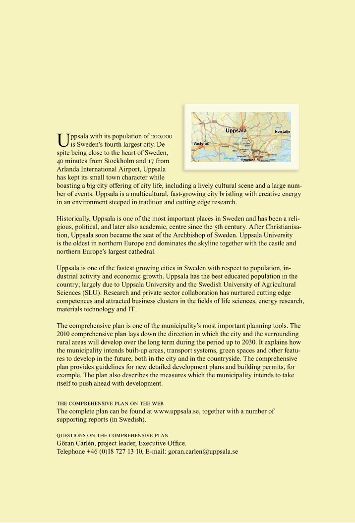
Uppsala with its population of 00,000 is Sweden’s fourth largest city. De-
spite being close to the heart of Sweden, 40 minutes from Stockholm and 17 from Arlanda International Airport, Uppsala has kept its small town character while boasting a big city offering of city life, including a lively cultural scene and a large num-ber of events. Uppsala is a multicultural, fast-growing city bristling with creative energy in an environment steeped in tradition and cutting edge research.
Historically, Uppsala is one of the most important places in Sweden and has been a reli-gious, political, and later also academic, centre since the 5th century. After Christianisa-tion, Uppsala soon became the seat of the Archbishop of Sweden. Uppsala University is the oldest in northern Europe and dominates the skyline together with the castle and northern Europe’s largest cathedral.
Uppsala is one of the fastest growing cities in Sweden with respect to population, in-dustrial activity and economic growth. Uppsala has the best educated population in the country; largely due to Uppsala University and the Swedish University of Agricultural Sciences (SLU). Research and private sector collaboration has nurtured cutting edge competences and attracted business clusters in the fields of life sciences, energy research, materials technology and IT.
The comprehensive plan is one of the municipality’s most important planning tools. The 2010 comprehensive plan lays down the direction in which the city and the surrounding rural areas will develop over the long term during the period up to 2030. It explains how the municipality intends built-up areas, transport systems, green spaces and other featu-res to develop in the future, both in the city and in the countryside. The comprehensive plan provides guidelines for new detailed development plans and building permits, for example. The plan also describes the measures which the municipality intends to take itself to push ahead with development.
the comprehensive plan on the web The complete plan can be found at www.uppsala.se, together with a number of supporting reports (in Swedish).
questions on the comprehensive plan Göran Carlén, project leader, Executive Office. Telephone +46 (0)18 727 13 10, E-mail: [email protected]
Uppsala
Stockholm
Norrtälje
Västerås

summary of the comprehensive plan for the uppsala municipality 010
... is an attractive place to live and work– Uppsala is an exciting city with an influential scientific, cultural and business life. The city’s working and living environments have so much to offer that Uppsala, together with Stockholm, has become the engine for growth in the Mälaren valley and a national resource for the development of Sweden as a whole.
...is a cohesive city – Uppsala has a diverse and dyna-mic culture. Its residents are increasingly becoming involved in and taking responsibility for social development and the local environment. Everyday life is straightforward and safety and accessibility have increased. Uppsala offers public spaces where residents can take part in sport and social activities. The city safeguards its cultural and natural assets, which help to contri-bute to its sense of identity.
...is becoming a climate-neutral city – The structure of the city and of the small towns and villages in the area encourage energy saving and climate-friendly energy use. The green spaces in the city and the surrounding country-side support biodiversity and provide clean water, a good micro-climate and the right conditions for agri-culture.
vision
Uppsala 00...
4 summary of the comprehensive plan for the uppsala municipality 010
The focus of the planthe development of the city
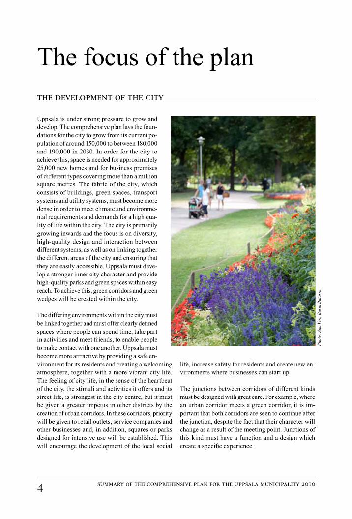
Uppsala is under strong pressure to grow and develop. The comprehensive plan lays the foun-dations for the city to grow from its current po-pulation of around 150,000 to between 180,000 and 190,000 in 2030. In order for the city to achieve this, space is needed for approximately 25,000 new homes and for business premises of different types covering more than a million square metres. The fabric of the city, which consists of buildings, green spaces, transport systems and utility systems, must become more dense in order to meet climate and environme-ntal requirements and demands for a high qua-lity of life within the city. The city is primarily growing inwards and the focus is on diversity, high-quality design and interaction between different systems, as well as on linking together the different areas of the city and ensuring that they are easily accessible. Uppsala must deve-lop a stronger inner city character and provide high-quality parks and green spaces within easy reach. To achieve this, green corridors and green wedges will be created within the city.
The differing environments within the city must be linked together and must offer clearly defined spaces where people can spend time, take part in activities and meet friends, to enable people to make contact with one another. Uppsala must become more attractive by providing a safe en-vironment for its residents and creating a welcoming atmosphere, together with a more vibrant city life. The feeling of city life, in the sense of the heartbeat of the city, the stimuli and activities it offers and its street life, is strongest in the city centre, but it must be given a greater impetus in other districts by the creation of urban corridors. In these corridors, priority will be given to retail outlets, service companies and other businesses and, in addition, squares or parks designed for intensive use will be established. This will encourage the development of the local social
life, increase safety for residents and create new en-vironments where businesses can start up.
The junctions between corridors of different kinds must be designed with great care. For example, where an urban corridor meets a green corridor, it is im-portant that both corridors are seen to continue after the junction, despite the fact that their character will change as a result of the meeting point. Junctions of this kind must have a function and a design which create a specific experience.
Pho
to: A
na V
era
Bur
in B
atar
ra

5summary of the comprehensive plan for the uppsala municipality 010
TransportThe city’s traffic and transport systems must be deve-loped to ensure that the proportion of journeys made on public transport more than doubles from its current level of thirteen percent by 2030 and the proportion of car traffic is reduced. This will also bring about a reduction in climate emissions from transport and allow the city to grow without congestion increasing. A well-developed public transport system will also promote equality, by allowing those residents who do not have a car to travel in comfort and safety.
A public transport system with an extensive capacity and fast and frequent services must be introduced gradually. The future network, which includes bus rapid transport (BRT) routes and supplementary rou-tes, is shown in the figure on page 6. The extent of the BRT routes will become established over time. The routes will initially be serviced by buses, but in future they may be developed to include tram lines
or personal rapid transport systems. Specific nodes and interchange locations must be created. Retail centres, such as Boländerna/Stormhatten, Gränby and Stenhagen, will function as interchange locations in the public transport system. New park-and-ride areas must be set up to reduce vehicle traffic in the inner city. Public transport must be given better access than cars to the most popular destinations, for example, the city centre, the university, the hospital area and the arenas. The rail system must be developed in the long term to allow commuter trains to be used for city travel, with new stations in Bergsbrunna, Gamla Uppsala and Librobäck.
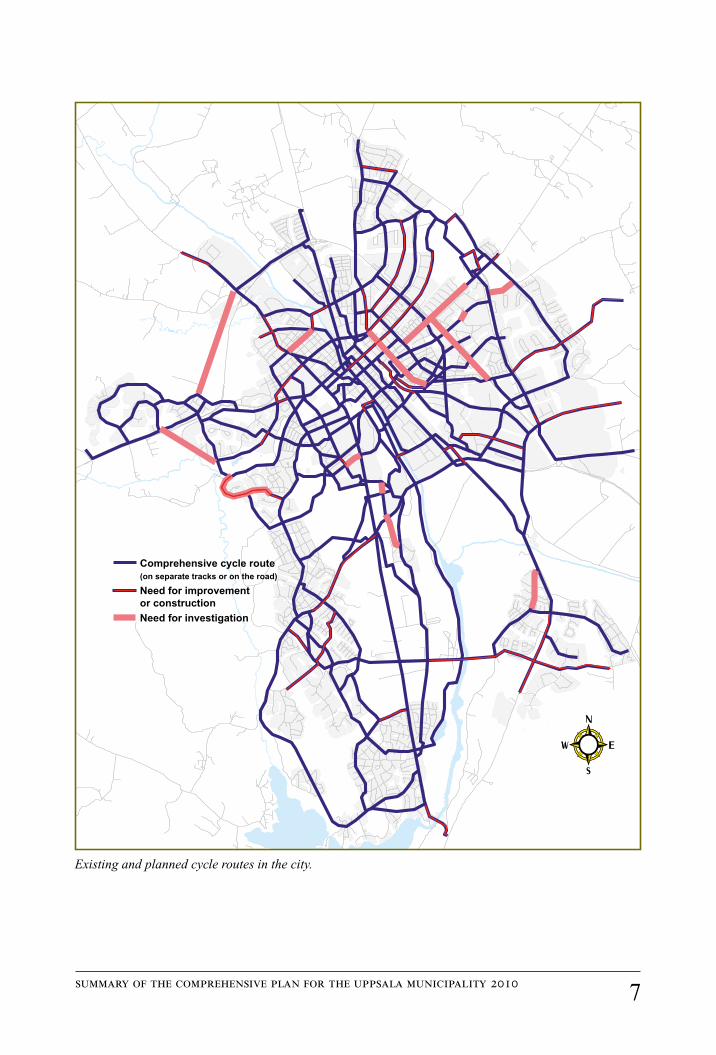
The inner city areas must be designed for ease of use by pedestrians and cyclists. The network of cycle routes in the city must be better connected and must also be linked to cycle routes leading out into the countryside and the villages. Parking areas for visi-tors must be given priority in multi-storey car parks.
Pho
to:
Dan
Pet
ters
on

summary of the comprehensive plan for the uppsala municipality 010
The city’s public transport system of the future.
B
Interchange location
Under investigation
Possible tram line
Bus rapid transport
Railway
Existing regional transport network
Supplementary route
Future supplementary route
Commuter parking/park-and-ride
Travel centre
Station
7summary of the comprehensive plan for the uppsala municipality 010
Existing and planned cycle routes in the city.
Comprehensive cycle route(on separate tracks or on the road)
Need for improvement or constructionNeed for investigation
K Renström 2010-02-10
summary of the comprehensive plan for the uppsala municipality 010
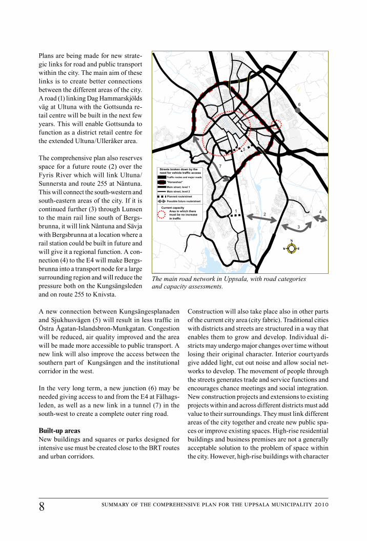
Plans are being made for new strate-gic links for road and public transport within the city. The main aim of these links is to create better connections between the different areas of the city. A road (1) linking Dag Hammarskjölds väg at Ultuna with the Gottsunda re-tail centre will be built in the next few years. This will enable Gottsunda to function as a district retail centre for the extended Ultuna/Ulleråker area.
The comprehensive plan also reserves space for a future route (2) over the Fyris River which will link Ultuna/Sunnersta and route 255 at Nåntuna. This will connect the south-western and south-eastern areas of the city. If it is continued further (3) through Lunsen to the main rail line south of Bergs-brunna, it will link Nåntuna and Sävja with Bergsbrunna at a location where a rail station could be built in future and will give it a regional function. A con-nection (4) to the E4 will make Bergs-brunna into a transport node for a large surrounding region and will reduce the pressure both on the Kungsängsleden and on route 255 to Knivsta.
A new connection between Kungsängesplanaden and Sjukhusvägen (5) will result in less traffic in Östra Ågatan-Islandsbron-Munkgatan. Congestion will be reduced, air quality improved and the area will be made more accessible to public transport. A new link will also improve the access between the southern part of Kungsängen and the institutional corridor in the west.
In the very long term, a new junction (6) may be needed giving access to and from the E4 at Fålhags-leden, as well as a new link in a tunnel (7) in the south-west to create a complete outer ring road.
Built-up areasNew buildings and squares or parks designed for intensive use must be created close to the BRT routes and urban corridors.
Construction will also take place also in other parts of the current city area (city fabric). Traditional cities with districts and streets are structured in a way that enables them to grow and develop. Individual di-stricts may undergo major changes over time without losing their original character. Interior courtyards give added light, cut out noise and allow social net-works to develop. The movement of people through the streets generates trade and service functions and encourages chance meetings and social integration. New construction projects and extensions to existing projects within and across different districts must add value to their surroundings. They must link different areas of the city together and create new public spa-ces or improve existing spaces. High-rise residential buildings and business premises are not a generally acceptable solution to the problem of space within the city. However, high-rise buildings with character
2
3
4Current capacity
Area in which there must be no increase
Streets broken down by theneed for vehicle traffic access
Traffic routes and major roads
"Horseshoe"
Main street, level 1
Main street, level 2
Planned route/street
Possible future route/street
1
7
5
3
21
6
in traffic
The main road network in Uppsala, with road categories and capacity assessments.

summary of the comprehensive plan for the uppsala municipality 010
can be constructed in locations outside the historic city centre, where this is appropriate given the sur-roundings, and providing that they help to strengthen public transport or the centre of a local district or encourage city life to develop in a desirable way.
A number of large areas for development are highligh-ted in the plan. The majority of these were made pu-blic some time ago. However, one new area is a broad strip along Dag Hammarskjölds väg from Ulleråker to Sunnersta (17) where various measures should be taken to link the districts together. Another is Kungs-ängens gård (15) to the south of Boländerna which has been proposed as an area reserved for large companies moving into the region, among other things.
Industrial businesses will still be encouraged to move out of central and semi-central locations to the out-skirts of the city and to highly accessible areas close to the city. New companies have a range of different environments to choose from. In the north-west of the city and to the south of Boländerna, land will be set aside for very large organisations to establish new facilities. In the inner city and the city centre more space will be made available for businesses of different types with high customer contact. The inner city and the city centre will expand both inwards and outwards. The urban corridors must be developed to offer an alternative to business start-ups in the inner city.
Inner city
Urban corridors and nodes (1)
BRT corridors and central areas (2)
BRT corridors and interchange locations, plus urban corridors and local centres. Here sites will be made available for new buildings and squares designed for intensive use.

10 summary of the comprehensive plan for the uppsala municipality 010
11
15
10
14
12
131
1718
16
3
67
4
5
8
9
2
Larger development areas within the city. This includes areas where programmes/detailed plans for development already exist (1-9) and areas where strategies for development have yet to be produced or are included in the comprehensive plan (10-18). 1 Librobäck, 2 Gränbyparken, 3 Blåsenhus, 4 Kungs-ängen, 5 Östra Fyrislund, 6 Rosendal, 7 Ulleråker, 8 Ultuna, 9 Vårdsätra-Skarholmen, 10 The city centre and inner city, 11 North-western areas of the city, 12 Tycho Hedéns väg, 13 The power line corridor, 14 Boländerna, 15 Kungsängens gård, 16 Gottsunda-Valsätra, 17 Dag Hammarskjöld corridor, 18 South-eastern areas of the city.
11summary of the comprehensive plan for the uppsala municipality 010
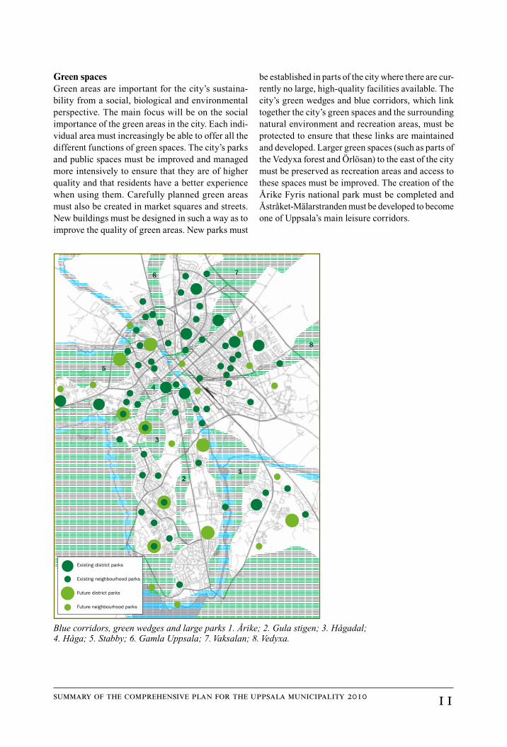
Green spacesGreen areas are important for the city’s sustaina-bility from a social, biological and environmental perspective. The main focus will be on the social importance of the green areas in the city. Each indi-vidual area must increasingly be able to offer all the different functions of green spaces. The city’s parks and public spaces must be improved and managed more intensively to ensure that they are of higher quality and that residents have a better experience when using them. Carefully planned green areas must also be created in market squares and streets. New buildings must be designed in such a way as to improve the quality of green areas. New parks must
be established in parts of the city where there are cur-rently no large, high-quality facilities available. The city’s green wedges and blue corridors, which link together the city’s green spaces and the surrounding natural environment and recreation areas, must be protected to ensure that these links are maintained and developed. Larger green spaces (such as parts of the Vedyxa forest and Örlösan) to the east of the city must be preserved as recreation areas and access to these spaces must be improved. The creation of the Årike Fyris national park must be completed and Åstråket-Mälarstranden must be developed to become one of Uppsala’s main leisure corridors.
12
3
4
5
6 7
8
Existing district parks
Existing neighbourhood parks
Future district parks
Future neighbourhood parks
Blue corridors, green wedges and large parks 1. Årike; 2. Gula stigen; 3. Hågadal; 4. Håga; 5. Stabby; 6. Gamla Uppsala; 7. Vaksalan; 8. Vedyxa.
1 summary of the comprehensive plan for the uppsala municipality 010
the countryside and small towns and villages
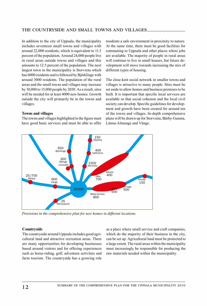
In addition to the city of Uppsala, the municipality includes seventeen small towns and villages with around 22,000 residents, which is equivalent to 11.5 percent of the population. Around 24,000 people live in rural areas outside towns and villages and this amounts to 12.5 percent of the population. The next largest town in the municipality is Storvreta which has 6000 residents and is followed by Björklinge with around 3000 residents. The population of the rural areas and the small towns and villages may increase by 10,000 to 15,000 people by 2030. As a result, sites will be needed for at least 4000 new homes. Growth outside the city will primarily be in the towns and villages.
Towns and villagesThe towns and villages highlighted in the figure must have good basic services and must be able to offer
residents a safe environment in proximity to nature. At the same time, there must be good facilities for commuting to Uppsala and other places where jobs are available. The majority of people in rural areas will continue to live in small houses, but future de-velopment will move towards increasing the mix of different types of housing.
The close-knit social network in smaller towns and villages is attractive to many people. Sites must be set aside to allow homes and business premises to be built. It is important that specific local services are available so that social cohesion and the local civil society can develop. Specific guidelines for develop-ment and growth have been created for around ten of the towns and villages. In-depth comprehensive plans will be drawn up for Storvreta, Bärby-Gunsta, Länna-Almunge and Vänge.
Skyttorp
VattholmaBjörklinge
Gåvsta
Knutby
BälingeLövstalöt
Järlåsa
Bärby-Gunsta
Vänge
Ramstalund
Storvreta
Jälla
150
400650
300
400700
1500
150
80025
900
25000
25/700
LännaAlmunge500
500
CountrysideThe countryside around Uppsala includes good agri-cultural land and attractive recreation areas. There are many opportunities for developing businesses based around visitors and for offering experiences such as horse-riding, golf, adventure activities and farm tourism. The countryside has a growing role
as a place where small service and craft companies, which do the majority of their business in the city, can be set up. Agricultural land must be protected to a large extent. The rural areas within the municipality must increasingly be responsible for producing the raw materials needed within the municipality.
Provisions in the comprehensive plan for new homes in different locations.

1summary of the comprehensive plan for the uppsala municipality 010
Interaction with the cityThere is a large amount of interaction between the city, small towns and villages and rural areas and this requires good communications. In the long term, priority must be given to developing public transport along routes 55, 72, 272, 288 and 282, together with the east coast rail line and the Dala rail line, with new stations in the city and possibly also in Vänge and Järlåsa. New homes and tourist businesses in the countryside benefit from their proximity to the major public transport corridors, such as routes 288 and 282, where there is the possibility of people taking day trips by public transport. Cars will continue to dominate rural transport, but more commuter parking areas will make car-pools and connecting with public transport easier. Areas of the countryside which are outside major or important regional corridors must have basic access by public transport, with several services running each day.
Important regional corridors
Public transport corridors in the Uppsala region.
Pho
to:
Dan
Pet
ters
on
Road/busRailNew E4

14 summary of the comprehensive plan for the uppsala municipality 010
Better passenger and goods transport is a prerequi-site for making Uppsala an attractive place to live, ensuring business growth and promoting well-being and prosperity. In order to improve Uppsala’s links with local and more distant regions, the transport infrastructure must be extended. This is primarily an issue for the Swedish government, but the compre-hensive plan highlights sites set aside for the changes described below, among others.
Railways The capacity of the east coast rail line and the Dala rail line must be increased and these lines must therefore be expanded to four and two tracks respectively. A new rail line from Enköping to Uppsala is also needed to improve communications between the western part of the Mälaren valley and Uppsala/Arlanda.
RoadsFollowing the completion of the E4 and Bärbyleden, the main priority is to improve routes 55, 288 and 282. Route 288 will be turned into a 3-lane main road (2 plus 1) in the next few years, over what is in part a new stretch. Further improvements may be needed following the decision to establish terminal storage
for nuclear fuel at Forsmark. The comprehensive plan highlights an area reserved for extending this road between the city and Örby.
Route 55 is one of the country’s hundred most dange-rous roads. Therefore, it will be turned into a 3-lane main road (2 plus 1) between Kvarnbolund and the boundary of the municipality. Pedestrians and cy-clists will be kept separate from vehicle traffic. On the stretch between the city and Berthåga, the plan allows for developments to improve road safety by lowering the road and building bridges over it.
The Swedish Transport Administration has carried out a preliminary study for the development of route 282 to Funbo and Almunge. However, no funding is available for this project until after 2020. The com-prehensive plan sets aside areas for developing this route into a 3-lane main road (2 plus 1).
AirfieldsThe military airfield at Ärna has been highlighted as being of national interest for civil air traffic. A licensing trial is currently underway for civil flights from the airfield.
overall transport infrastructure
Pho
to:
Bil
dark
ivet

UPPSALA OM TJUGO ÅRen sammanfattning av översiktsplan 2010
Tekn
ik &
ser
vice
, Upp
sala
kom
mun
2010 5
04 3
79