Embed Size (px)
Citation preview

Mike Halliburton Associates and Transplan Pty Ltd 1
Upper Hunter Country Rail Trail
TRAILDEVELOPMENTPLAN

Mike Halliburton Associates and Transplan Pty Ltd 2
Upper Hunter Country Rail Trail
Feasibility Study
December 2016
Prepared by:

Upper Hunter Country Rail Trail Trail Development Plan
Mike Halliburton Associates and Transplan Pty Ltd 3
Contents
Executive Summary 4
Recommendations 6
Section 1 – Background 7
Section 2 – The Scope of Works for this Project 9
Section 3 – Trail Design and Development Considerations 11
Section 4 – Works Lists and Probable Costs 33
Section 5 – Construction Management 73
Section 6 – An Implementation Program 79
Section 7 – Corridor Management and Operations Plan 81
Appendix 1 – Cross Sections, Drawings and Photos 108
Appendix 2 – Trailhead Drawings 117
Appendix 3 – Road Crossing Drawings 122
Appendix 4 – Halls Creek Bridge Report 127
Appendix 5 – Example Rail Trail Maintenance Checklist 135
Appendix 6 – Rail Trail Plans 1 – 4 139

Upper Hunter Country Rail Trail Trail Development Plan
Mike Halliburton Associates and Transplan Pty Ltd 4
Executive Summary
This Trail Development Plan sets out a detailed set of activities for the progressive construction of a trail on the disused railway between Merriwa and Sandy Hollow (spanning the Shires of Upper Hunter and Muswellbrook). Section 4.0 contains several tables where a comprehensive works list for each of the proposed 4 stages of the rail trail development is set out, and an estimate of probable costs for each task.
The Upper Hunter Country Rail Trail Feasibility Study (prepared in 2015) provided an estimate of the likely costs involved in establishing the rail trail between Merriwa and Sandy Hollow. The project was estimated to cost around $7.4 million. An additional cost of $80,500 was estimated for providing an on-road extension of the trail between Sandy Hollow and Denman.
The detailed cost estimates provided in this trail development plan are not substantially different to the 2015 estimate. The estimated detailed cost of the project is $7.781 million.
For the feasibility Study, the assessment of the condition of the corridor was done by observations from a distance and inspections where possible at road crossings – the usual level of inspection undertaken during the preparation of a rail trail feasibility study. In preparing the detailed Trail Development Plan, the entire corridor was traversed by foot and consequently much more is known about the requirements to convert the corridor to a rail trail. The primary costs differences between the 2015 estimates and the 2016 cost estimates (noting that the difference is only 4.7%) are:
Less fencing is required. The 2015 Feasibility Study allowed for a total of almost 65,000 metres of fencing. Detailed inspection of the corridor revealed the need for only 41,000 metres. At a cost of $15/metre, this is a substantial saving.
On the other side of the ledger, there is a significantly increased cost for bridgework, notably the installation of new bridges. The Feasibility Study allowed for the refurbishment of 120 metres of existing bridges (in addition to the repairs to the major bridge over Halls Creek). Unfortunately, detailed inspection of the corridor revealed the need for 25 new (pre-fabricated) bridges plus a new steel truss bridge north of Sandy Hollow. This has been the significant cost discrepancy between the 2015 and 2016 reports.
In the cost estimates that follow, an estimate has been made for the removal of the steel track and sleepers. It is a major cost (at $33/metre for a total of over $1.3 million). The ownership of the track and responsibility for removal (and any sale proceeds) is yet to be resolved and is part of the Tumbarumba-Rosewood Rail Trail pilot project underway. If the removal of track and sleepers can be a cost-neutral exercise, this will significantly reduce the trail costs.
When the contractors are removing the track and sleepers, the project manager should ensure that the embankments and cuttings of the former railway are left in an acceptable condition. Furthermore, the contract should ensure that when the track is being removed the contractors should be required to grade and level the embankment/formation following removal of the track. Care when removing track

Upper Hunter Country Rail Trail Trail Development Plan
Mike Halliburton Associates and Transplan Pty Ltd 5
from the remaining two bridges is also critical. Experience from other rail trails indicates that substantial and at times irretrievable damage to bridges can occur if removal of the track is not done with care and strict supervision.
Inspections of all timber bridges (the two major bridges plus two minor bridges) by a qualified structural engineer will determine their suitability for use by walkers and cyclists. This plan provides detail for the re-decking of the bridges to make them suitable for non-motorised trail users. The provision of handrails on the bridges is an essential component of the design. Section 3 contains a detailed discussion of the merit in keeping and re-using the timber bridges for rail trail users.
There are many unknowns when dealing with the construction of rail trails such as this. The exact condition of each bridge is not known and will not be known until qualified structural engineers assess each bridge. An allowance has been made for this assessment in the works tables. The extent of approvals needed prior to development of the trail and the requirement for permits and additional studies is not known but an allowance has been made.
The Feasibility Study (2015) recommended the promotion of a signposted on-road cycle route utilising quiet ‘backroads’ (Bylong Valley Road and Yarrawa Road) to extend the rail trail beyond Sandy Hollow to Denman. The three route options canvassed in the Feasibility Study were again investigated and there was no new evidence that the recommended route should be changed. However, there remains the key issue that the extension will only attract experienced cycle tourists rather than less experienced rail trail users, given the distance and the safety issues associated with riding on roads (even though they may be lightly trafficked).
It is likely that many of the economic benefits identified in the Feasibility Study arising from the rail trail development will accrue to Denman as the key accommodation provider.
Experienced touring cyclists will feel comfortable riding on Bylong Valley Road and Yarrawa Road after completing the rail trail. All promotional literature for the rail trail should include notes that users can continue to ride from Sandy Hollow to Denman via the Bylong Valley and Yarrawa Roads (the link could be shown as a dotted line on any associated mapping). The literature should clearly identify that it is an on-road cycle touring route suitable for experienced cycle tourists only. No dedicated trailhead at Denman is needed but all information material for Denman (brochures, website, information bays, any relevant new developments) should refer to the rail trail and how it can be accessed.
Trail directional signage (marker posts, and trail logo and directional arrows on the two relevant post faces) should be installed at all decision points (intersections) along the route. The estimated cost of this improvement is $1,600.
It is worth noting that the benefits of this project are not included in this report. These benefits have been addressed at length in the 2015 Feasibility Study.
Upper Hunter Country Rail Trail Trail Development Plan
Mike Halliburton Associates and Transplan Pty Ltd 6
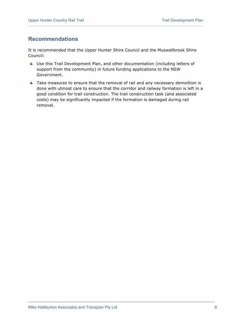
Recommendations
It is recommended that the Upper Hunter Shire Council and the Muswellbrook Shire Council:
Use this Trail Development Plan, and other documentation (including letters of support from the community) in future funding applications to the NSW Government.
Take measures to ensure that the removal of rail and any necessary demolition is done with utmost care to ensure that the corridor and railway formation is left in a good condition for trail construction. The trail construction task (and associated costs) may be significantly impacted if the formation is damaged during rail removal.

Upper Hunter Country Rail Trail Trail Development Plan
Mike Halliburton Associates and Transplan Pty Ltd 7
Section 1 - Background
The Merriwa railway line is in central northern New South Wales, Australia. The line branches from the Main North line at Muswellbrook and travels north through Sandy Hollow to the town of Merriwa, a distance of approximately 80 kilometres. There were stations at Gungal and Wappinguy (nothing of either remain). The line opened on 29 October 1917. The section of railway north of Sandy Hollow closed in 1988. The section between Muswellbrook and Sandy Hollow is still open as part of the Ulan line between Muswellbrook and Gulgong on the Gwabegar railway line.
Since the branch line closure in 1988 the rail yard at Merriwa has remained relatively intact. The engine shed, barrack building, coal stage and water tower were removed in 1970s. However, the railway station, goods shed, gantry crane, water column and turntable remain in place, as does the entire railway track.
There have been several attempts to launch a rail preservation group to restore and maintain the Merriwa station precinct and the section of line between Sandy Hollow and Merriwa.
In 2015 a Feasibility Study examining the merit of developing a ‘rail trail’ on the disused railway line (with an ‘on-road’ extension to Denman) was undertaken. (A rail trail is the conversion of a disused railway into a multi-use recreation path, typically for walking, cycling and sometimes horse riding. The characteristics of abandoned railways - flat, long, frequently running through historical areas - are appealing to numerous potential user groups).
That 2015 Feasibility Study found that:
o A trail from Merriwa to Sandy Hollow (on the railway corridor) and on to Denman (as a marked cycle touring route) is feasible from a technical and economic viewpoint.
o The trail, if constructed, the trail will attract local users, day-trippers and visitors.
• Significant local use (in terms of the percentage of the local population using the rail trail) – almost 4,000 local trips/year is a reasonable expectation. This will result in an economic injection of $8,184/year;
• Expansion of the existing day-tripper market to the region. 7,000 day-trippers/year will yield an injection of $679,630/year.
• With a new significant recreation attraction, some day-trippers may stay overnight, generating a new income stream. If the trail converted 1,500 day-trippers into overnight visitors, this would inject an additional $247,500/year into the economy.
• If 1,500 visitors stay an extra day to use the trail (or use a package of trails including the Upper Hunter Country Rail Trail), this would represent less than 1% of existing overnight visitors. Attracting this number of users would see an additional $247,500/year injected into the economy.

Upper Hunter Country Rail Trail Trail Development Plan
Mike Halliburton Associates and Transplan Pty Ltd 8
o The total injection of dollars into the local economies from local, day trip and overnight visitors may be of the order of $1,182,814 per year (under a range of conservative scenarios).
o The costs of construction of the proposed Upper Hunter Country Rail Trail were estimated at $7,430,030, with an additional $80,500 to construct an on-road, signposted cycle route between Sandy Hollow and Denman.
In 2016, the Upper Hunter Shire Council and the Muswellbrook Shire Council accepted the Feasibility Study and determined to proceed to the next stage of work – a detailed Trail Development Plan.
This Trail Development Plan provides the two Councils with a construction blueprint, enabling them to proceed with the establishment of the rail trail (should they determine this to be the appropriate course of action) once funds become available and legislative impediments are removed.
Rail trails in NSW are being progressed through the development of a pilot project – a rail trail from Tumbarumba to Rosewood (southern NSW). The NSW Government is using the pilot project to answer a number of questions including enabling legislation and “project success”. There will be no progress on other rail trails until the pilot project has been assessed. Once this project has been assessed, the Government may determine to fund other rail trail projects. The Upper Hunter Shire Council and the Muswellbrook Shire Council will be in a good position to seek funding having prepared a feasibility study and a trail development plan, as well as addressing a range of other matters outside the scope of this Plan (notably but not only gathering community support).

Upper Hunter Country Rail Trail Trail Development Plan
Mike Halliburton Associates and Transplan Pty Ltd 9
Section 2 – The Scope of Works for this Project
The Terms of Reference for the Trail Development Plan outline the broad scope of works.
The Rail Trail Development Plan will utilise the findings and outcomes of the Upper Hunter Country Rail Trail Feasibility Study (August 2015), between Merriwa and Denman, incorporating all issues identified within that report. It will provide the following:
a) A detailed analysis of the proposed rail trail alignment, addressing all tenure, ownership and access issues, and involving consultation with all key stakeholders. This analysis is to reference, but not be constrained by, any previous feasibility studies relating to this rail trail corridor. The outcome of this analysis shall be a set of clear proposals enabling the development of a continuous rail/road trail between Merriwa and Denman – distance of 64km.
b) In consultation with the client, identify the key user groups.
c) For the full length of the rail trail, identify any section that may not be suitable for all user groups and present alternative routes/options where feasible (e.g. disability access needs, or consideration of provision for horses, competing use of rail corridor with coal trains).
d) Identify;
• access needs to and from the rail trail, including location and schematic layout of trailheads and car parks plus emergency access requirements. Include consideration of the need for associated infrastructure such as parking, vehicle access, picnic areas, toilets (if any) and water points.
• linkage to places and elements of interest and infrastructure outside the rail trail corridor (such as tourist attractions, toilets, food & beverage outlets and accommodation).
• signage needs (warning, code of conduct, directional, distance, safety, general information, emergency signage) including locations and schematic design but not detailed content of information signs. Particular consideration shall be given to signage to manage safety and risk at critical locations such as road crossings.
• location and schematic design of structures (including signs) for safety and to control unauthorised access to the rail trail (e.g. gates, barriers, chicanes, “slow points” and the like at the approach to road crossings).
e) Schematic design for all necessary works to construct the trail and associated infrastructure (such as trail surfacing, signs, gates, bridges and fencing).
f) Compilation of works lists for all matters required to ensure the successful development of the proposed rail trail (including clearing, removal of line and sleepers, trail surfacing, drainage, signage, fencing and gates, trailheads, road crossings, bridge repairs or replacement, tunnels, culverts, stock crossings, revegetation, trailside furniture etc).
Upper Hunter Country Rail Trail Trail Development Plan
Mike Halliburton Associates and Transplan Pty Ltd 10
g) Estimate of probable cost for construction of the rail trail (including costs for clearing, removal of existing line and sleepers, trail surfacing, drainage, signage, fencing and gates, trailheads, road crossings, bridge repairs or replacement, tunnels, culverts, stock crossings, revegetation, trailside furniture etc).
h) Recommended timeframe for development of the various elements and sections of the rail trail. Consideration of opportunities for ‘staging’ sections of the rail trail should be clearly listed.
i) Draft management and maintenance plans, designed to ensure the long-term structural and management viability of the rail trail.
j) Mapping of rail trail alignment with locations of all major works required.
k) Drawings, cross sections, illustrations and photographs that show how the rail corridor is now and how it might look after construction of the rail trail.
Upper Hunter Country Rail Trail Trail Development Plan
Mike Halliburton Associates and Transplan Pty Ltd 11
Section 3.0 - Trail Design and Development Considerations
3.1 General Considerations
This section of the Trail Development Plan addresses a series of matters relating to trail design and development of the Upper Hunter Country Rail Trail – to achieve a rail trail that is constructed with minimal disturbance to the natural environment, is sustainable and that requires minimal maintenance.
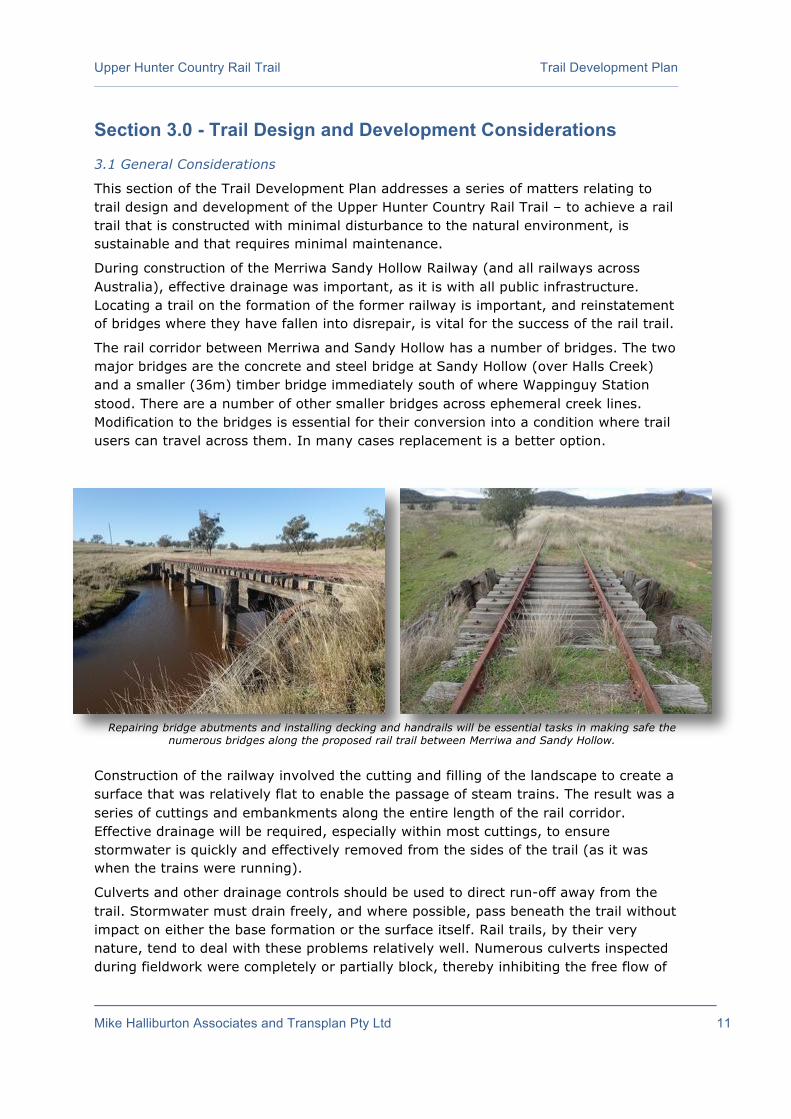
During construction of the Merriwa Sandy Hollow Railway (and all railways across Australia), effective drainage was important, as it is with all public infrastructure. Locating a trail on the formation of the former railway is important, and reinstatement of bridges where they have fallen into disrepair, is vital for the success of the rail trail.
The rail corridor between Merriwa and Sandy Hollow has a number of bridges. The two major bridges are the concrete and steel bridge at Sandy Hollow (over Halls Creek) and a smaller (36m) timber bridge immediately south of where Wappinguy Station stood. There are a number of other smaller bridges across ephemeral creek lines. Modification to the bridges is essential for their conversion into a condition where trail users can travel across them. In many cases replacement is a better option.
Construction of the railway involved the cutting and filling of the landscape to create a surface that was relatively flat to enable the passage of steam trains. The result was a series of cuttings and embankments along the entire length of the rail corridor. Effective drainage will be required, especially within most cuttings, to ensure stormwater is quickly and effectively removed from the sides of the trail (as it was when the trains were running).
Culverts and other drainage controls should be used to direct run-off away from the trail. Stormwater must drain freely, and where possible, pass beneath the trail without impact on either the base formation or the surface itself. Rail trails, by their very nature, tend to deal with these problems relatively well. Numerous culverts inspected during fieldwork were completely or partially block, thereby inhibiting the free flow of
Repairing bridge abutments and installing decking and handrails will be essential tasks in making safe the numerous bridges along the proposed rail trail between Merriwa and Sandy Hollow.

Upper Hunter Country Rail Trail Trail Development Plan
Mike Halliburton Associates and Transplan Pty Ltd 12
stormwater under and away from the railway embankment. Regular cleaning of blocked culverts is essential to avoid serious soil and water degradation problems.
Particular care must be given to reinstating the side (cess) drains through cuttings. There may be instances where it would be preferable to use additional trail surfacing material (fill) to raise the rail trail above the (former) side (cess) drains in cuttings, as the drains are now well grassed and effectively prevent erosion from occurring. The works list (Section 4) identifies such a treatment for all cuttings – it is recommended that the trail surface be rebuilt to 300mm depth through cuttings (rather than the standard 150mm). (See drawings in Appendix 1 show both options).
Construction of the rail trail and associated signage should comply with relevant Australian Standards and Austroads guidelines. The works lists outlined in Section 4 delivers a trail to meet these requirements.
At some point in the future, (when the rail trail is funded) contractors will be engaged to remove the steel railway track and sleepers. Care will need to be taken by the contractors to ensure that the formation and bridges are left in as good a condition as possible to minimise rail trail construction difficulties. It is strongly recommended that the two Councils (and their contractors) leave the steel track and sleepers on the timber bridge at Wappinguy as their existence will help tie all bridge components together and thereby maintain a more rigid, stronger and longer lasting structure. Cutting of the steel track several metres either side of the bridge abutments should suffice. At two locations, it is recommended that the steel track be removed and the remaining I-beams be re-used. The drawings in Appendix 1 illustrate different ways of installing timber decking on the remains of old railway bridges.
3.2 Trail Width and Height
To function effectively as a shared use facility (for cyclists and walkers and, where permitted, horses), the Upper Hunter Country Rail Trail should have a width of 2.5 metres. Anything wider than that and the trail starts resembling a gravel road, which is not want rail trail users want. The width of the existing embankment/formation of the original railway will ultimately determine the width that the proposed rail trail can be constructed in some locations.
Some sections of the former railway reserve are currently used for farming purposes (grazing etc.), or as access to farming properties, or as access between paddocks, and this access can be retained without seriously diminishing trail user experiences (subject to trail manager approval).
The railway has been disused since 1988. During this time some sections of the corridor have become overgrown, and will require clearing for the passage of trail users. Where vegetation has regrown, overhead clearance should be maintained to approximately 2.4 metres from the rail trail surface. All overhanging vegetation – and that which intrudes from the sides into this ‘corridor’ should be cut back on a regular basis. Care should be taken that sharp and dangerous ‘points’ are not left in this pruning process.
There are instances where side vegetation can be retained, as the trees are attractive and provide shade. They also provide an attractive vista along the cutting or embankment.

Upper Hunter Country Rail Trail Trail Development Plan
Mike Halliburton Associates and Transplan Pty Ltd 13
Drawings in Appendix 1 illustrate typical cross sections for the proposed rail trail, including through a typical cutting.
3.3 Trail Surface Material
A smooth compacted surface is most appropriate for a shared-use rail trail. The surface should be firm enough to provide cyclists (the predominant user group of rail trails) with a relatively smooth ride.
Most rail trails developed in Australia use a locally available earth surface (gravel, decomposed granite, crushed limestone, etc.) to produce a firm surface easily capable of accommodating walkers and cyclists. Use of such material provides a high quality natural surface without the expense of a hardened (i.e. sealed) surface.
Generally speaking, asphalt, concrete and other such hard surfaces are not appropriate on rail trails. However, there are some good arguments for sealing the surface of some rail trails – users on road bikes are able to use such a trail and the very successful Murray to the Mountains Rail Trail (Victoria) is a sealed trail. Usually, the costs of putting down a hard surface and the aesthetics of a hard surface are arguments against a hard surface.
It is not appropriate to allow the trail surface to deteriorate into either a soft sandy material or a wet, boggy or slippery condition. Soft sand is not acceptable to cyclists or walkers. Water-logged trails are quickly damaged and degraded and are very unpleasant to traverse. Loose surfaces such as ball-bearing gravel are also unacceptable as they pose safety risks to all trail users (walkers, mountain bike riders, horse riders).
Cement stabilisation of the rail trail surface at each ‘stock crossing’ is strongly recommended to ensure the regular passage of stock across the rail trail does minimal damage to the trail surface and is long-lasting.
Given the nature of the existing railway formation between Merriwa and Sandy Hollow, where a considerable amount of ballast remains in place in some sections, and in many other parts of the corridor numerous small stones are evident, grading will be required prior to a surface material being applied. No ballast is to be left on the trail formation. It is too rough for bike users in particular and significantly detracts from the user’s experience.
Contractors engaged to remove the steel railway track and sleepers should be required to grade the formation to provide a level surface (after removal of the infrastructure). This will be a significant cost saving measure, and has been factored into the trail surfacing costs. Side drains must be maintained and not filled in when grading. It is recommended that the contractors engaged to remove the steel railway tracks and sleepers be instructed to undertake their tasks with maximum care so as to leave the formation/embankment in a usable condition. Despite this care, and given the nature of the formation some grading and re-surfacing will be required. The removal of the sleepers will leave what is often called a ‘sleeper shadow’ – the indentation that is left once the sleepers have been removed. Simply filling these indentations with fill will in time result in an undulating surface as the newly placed fill material settles in.
Upper Hunter Country Rail Trail Trail Development Plan
Mike Halliburton Associates and Transplan Pty Ltd 14
After the removal of the sleepers, a light grading of the surface is recommended. Care should be taken not to create berms of ballast on the side of the trail which have the effect of trapping the water in the trail formation i.e. creating a dam effect. Care should also be taken to ensure in cuttings that the ballast is not simply pushed in to the existing drainage measures (cess drains) on the side of the trail or these will have the effect of preventing the drains from performing as they should. Grading should be followed by the spreading and compacting (by vibrating roller) of the new surfacing material.
The 2015 Feasibility Study recommended that the Councils lead the discussion on whether horses are accommodated within the rail trail corridor. The study set out the reasons for the debate. It is understood that this matter has yet to be resolved. If horses are to be permitted, it is important to keep horses off the main trail surface as the hooves of horses can do significant damage to unsealed trail – although the level of damage depends on the surfacing material used and the prevailing weather conditions. Some surfacing materials (such as “Lilydale Toppings” as used on the Lilydale Warburton Rail Trail in the Yarra Valley in Victoria) are very accommodating to horses’ hooves.
The most effective method of accommodating horses is by the establishment of a separate bridle trail – usually a signposted, slashed single-track route off to the side of the main trail (but still within the original railway reserve). This is commonly done on rail trails such as the Great Victorian Rail Trail, the High Country Rail Trail (also in Victoria) and others. The bridle trail route can be simply constructed by slashing the low grass. The constant passage of horses will keep the sandy ‘single-track’ clear of regrowth and clearly defined. Bridle trail signage will be required to show riders where to go and to keep them off the main trail. Horses will need to share bridges where they cross watercourses.
In the costs estimates that are included within this Trail Development Plan, an allowance has been made for clearing of the trail corridor (vegetation and top soil and ballast), further grading and shaping of the formation to create as smooth a surface as possible, and additional fill material. An allowance has also been included for slashing a separate horse trail.
3.4 Safety Considerations
The most significant safety issue is that of potential conflict between road users (cars and trucks) and users of the proposed rail trail – especially at road crossings. This is more fully dealt with in ‘Road Crossings’ (see Section 3.5).
Another major safety issue is that of the bridges over the watercourses. This is dealt with in detail in Section 3.8.
Possible conflicts between different types of trail users is a potential safety issue. Users in conflict can be both legal and illegal – for example, between trail users (walkers and cyclists) and trail bikes or 4WD’s that have illegally accessed the rail trail. Effective signage and vehicle exclusion barriers (management access gates and self-closing gates for trail user access, or chicanes) will greatly limit this potential problem.
Dogs can be a potential safety consideration on this rail trail, as the corridor passes many farming properties, many of which have dogs, and numerous properties that

Upper Hunter Country Rail Trail Trail Development Plan
Mike Halliburton Associates and Transplan Pty Ltd 15
have stock. Often, dogs can be permitted on a trail in the “town” areas limiting potential interactions with livestock. However, given the “town” areas of the proposed trail are so limited, the recommended solution for this trail is a complete ban on dogs, enforced by Council rangers.
The incidence of conflict between trail users and motor vehicles at road crossings is reduced due to there being only a few road crossings along the rail trail.
3.5 Road Crossings
Road / trail crossings always present a special hazard which must be addressed carefully. A crossing should have enough space cleared and levelled on both sides of the road to allow cyclists travelling together to gather in a group and cross en masse. One-at-a-time crossing greatly increases the overall time in the roadway and therefore increases the likelihood of encountering a vehicle. The crossing should ideally be at a straight, level area allowing both trail user and vehicle driver good visibility and the driver ample stopping distance (if possible). All trail crossings should be perpendicular to the road.
The 5 road crossing concept drawings that form part of this Trail Development Plan (see Appendix 3) illustrate the signage that is required at each road crossing and the positioning of gates (for management access vehicles and for trail users).
Signs required to create safe road crossing are outlined in Section 3.6. The rail trail should be clearly marked on each side of the road for easy recognition and the crossing be designed to move the trail user away from the road reserve as quickly as possible.
Details pertaining to shared path crossings of roads can be found in Austroads Guide to Road Design Part 4: Intersections and Crossings – General (Australia).
Generally, the road crossing treatment required includes:
Installation of signage on the rail trail (both sides of the road crossing) advising (or warning) of the upcoming crossing of the road. The recommended treatment is the installation of both “Give Way” (or “Stop” signs if it is a major road) and “Road Ahead” signs on both sides of the crossing;
“Trail Crossing Warning Signage” on the road (both sides of the trail crossing) alerting road users of the upcoming trail crossing;
Management access gates and chicanes (permitting access by legitimate trail users and authorised vehicles, such as emergency services vehicles and management vehicles). A technical drawing setting out the specifications for chicane gates can be found in Appendix 1 along with an artist’s impression and a photo of such a gate on the Lilydale Warburton Rail Trail in Victoria;
Installation of pipe culverts (where required); and
Miscellaneous signage (including Rail Trail name and logo; distance signs; Emergency Marker signs; road name signs; “Unauthorised Vehicles Prohibited” signs; “Trail Bikes Prohibited” signs, etc.).

Upper Hunter Country Rail Trail Trail Development Plan
Mike Halliburton Associates and Transplan Pty Ltd 16
3.6 Signage
Several kinds of signage are required on the Upper Hunter Country Rail Trail, including distance, directional, warning, promotional, etiquette and interpretive signs. Each should be standardised along the rail trail and, where appropriate, concordant with relevant local or Australian ‘standards’ or practices. The chosen colours of all signs should be uniform throughout the trail.
Themes and styles already established for other rail trails in Australia, and in keeping with the uniformity in signage sought by Railtrails Australia, may dictate what style of signs and marker posts are used along this rail trail. Trail markers and signage on other rail trails are sometimes affixed to old (recycled) railway sleepers or recycled plastic posts.
In the case of the Upper Hunter Country Rail Trail, given the huge number of railway sleepers to be removed from the line when it is removed, it would seem sensible to pick the best of the available timber sleepers and re-cycle them.
3.6.1 Distance Signage
Recognising that users will join a rail trail at any number of points, installing distance and direction signs at road crossings will not only benefit those joining the rail trail at that location, but provide additional information for users already on the rail trail. The plate should indicate the distance to the upcoming localities along the rail trail (in particular, upcoming trailheads and towns). In addition, such signage provides good reference points for emergency services (in addition to the Emergency Marker signs - see below). Trail distance signage will need to be placed at regular intervals along the route. The obvious location is at each road crossing (and trailheads) where trail users are likely to
Above: Signage for the Tiger Rail Trail in Victoria warns of the upcoming road crossing as well as promoting its
existence to road users. Right: different signs may need to be used, depending on trail user groups being
permitted on the proposed trail.

Upper Hunter Country Rail Trail Trail Development Plan
Mike Halliburton Associates and Transplan Pty Ltd 17
join the trail. It is proposed to implement standard signage addressing distance requirements and emergency requirements every 1 km.
The recommended distance sign plates (as with all other signs) should be affixed with at least 4 stainless security screws to prevent them being removed. In addition, the distance signs (as well as the various other sign panels used on the posts) should be affixed with silastic or ‘liquid nail’ products
3.6.2 Warning Signage
There are a number of locations along the proposed Upper Hunter Country Rail Trail that demand warning signage, primarily at the many road crossings facing trail users. In the case of road crossings, a “Road Ahead” yellow diamond warning sign (W6-8A) some 50-70 metres before a crossing is recommended (on a stand-alone post), with a triangular “Give Way” sign (R1-2) on the verge at the road crossing (on a stand-alone post) – or a “Stop” sign where appropriate (R1-1 – 300 x 300). Bicycle/pedestrian (i.e. Trail Crossing) warning signs (W6-9) with arrow (W8-23) (or W6-V105) are recommended for installation on roads, either side of a trail crossing, or use of “Crossing Ahead” signs as indicated above.
The proposed rail trail has 4 road crossings along the route, and some of these provide both challenges and opportunities for trail development. The challenges come in ensuring that these crossings are safe for future trail users, while the opportunities surround the passing road users who can be alerted to the trail’s presence. Such ‘opportunistic’ promotion can only be good for the future of the rail trail in raising awareness and increasing user numbers.
3.6.3 Promotional Signage
Promotional signage has been used to great effect on other rail trails throughout Australia, increasing general awareness of the trail among the broader community. For the proposed Upper Hunter Country Rail Trail, the recommended ‘promotional’ sign should be incorporated into the on-road ‘Crossing Ahead’ warning signs (such as has occurred on the Forrest Birregurra Tiger Rail Trail). They are an excellent means of communicating the message to road users that they need to be alert for the presence of cyclists and pedestrians (and horse riders).
Though the railway corridor may be quite likely familiar to many local residents, it is recommended that a number of “Trailhead” signs also be erected to give prominence to the trail when constructed. The installation of these signs will enable local people
Signs pointing in to the “Trailhead”, as used on the High Country Rail Trail in Victoria, are an excellent means of directing trail users to a
Trailhead and serve to promote the existence of the rail trail to passing motorists, tourists and local people.

Upper Hunter Country Rail Trail Trail Development Plan
Mike Halliburton Associates and Transplan Pty Ltd 18
and visitors become more aware of the trail (a good example is the High Country Rail Trail). The trailhead drawings in Appendix 2 indicate the placement of these types of signs on the major roads near to the trailhead.
3.6.4 Permitted User Signage
Signs (in the form of pictograms) indicating user groups that are permitted (or not permitted) on the various sections of the Upper Hunter Country Rail Trail should be installed at every road crossing and entry point. These small signs can easily be installed on the totem posts near to the proposed trail user access gates (chicanes) or even on the gates/chicanes themselves. Pictogram signage could include “No Motor Vehicles”, “No Motor Bikes”, “No Smoking”, “No Alcohol” and “No Dogs”. The installation of “No Motor Vehicles” and “No Motor Bikes” are recommended at the outset, and the trail manager will ultimately determine what other signage may be required.
3.6.5 Interpretive Signage
On-trail interpretation is becoming more and more of a feature of trails built in recent times. When well done, it can add significantly to the depth of the user’s experience. It can also generate a sizeable cost, and can be subject to ongoing vandalism in urban and rural areas.
All rail corridors are inevitably rich with history, not just European settlement history but also indigenous and natural history. The Merriwa to Sandy Hollow corridor is no different. People will move along this trail at a leisurely pace. This slower rate of travel, a more relaxed frame of mind and openness to new experiences provide ideal circumstances to educate trail users on all aspects of the country through which they pass. There are many stories that can be told along rail trails. The provision of interpretive material will greatly enrich the experience of visitors to the rail trail.
Effective interpretive material gives a specific “flavour” of the events, landforms, wildlife, and vegetation relevant to a specific site. The intention is for the traveller to develop a deeper understanding of the multitude of stories contained in a region. Conversely, the themes can be designed to spark interest, encouraging people to explore any story that interests them. It may also encourage them to extend their stay in the region to further pursue an interesting story or theme.
Interpretive signage does not need to be in place from the trail opening (though this would be a commendable outcome) but at least some information should be embodied in the trail brochure. Interpretation should be an integral part of any trail’s development process.
The works tables make allowance for the placement of a number of panels along the rail trail. Of particular interest is the possible location of an historic well immediately east of Merriwa station ground. Whilst it could not be located during fieldwork, the Historical Society is likely to know of its location within the rail corridor.

Upper Hunter Country Rail Trail Trail Development Plan
Mike Halliburton Associates and Transplan Pty Ltd 19
3.6.6 Emergency Management Signage
Distance signage provides good reference points for emergency services. It gives anyone who needs emergency assistance an easy reference point. On other projects, consultation with ambulance officers in particular highlighted this need. When people panic (as they often do in an emergency situation), normal cognitive processes do not work. On-trail signage should be as helpful as possible and minimise likely stress. Consequently, distance signs should be installed at regular intervals, with distances to the next trailhead or major town or road crossing (on either side of the post). This enables people to quickly identify where they are by travelling a very short distance from the emergency situation. All road crossings should also have a GPS reference/identifier on the chicane (or on a separate post) for use in emergencies, again as a location aid for those in stress. There is also a need to include the emergency telephone number at all trailheads (on the trailhead map panel) and clearly identify that one number will contact all three emergency services (police, ambulance, fire). While the emergency number from a landline is 000, the emergency number that works best from a mobile phone is 112. Information on what to do in an emergency, the location of public phones (there may be none on the trail itself), and the capacity for a flip-down sign indicating trail closure (due primarily to fire, flooding or maintenance work) should also be included at each trailhead.
It is strongly recommended that “Emergency Markers” be installed along the Upper Hunter Country Rail Trail.
In summary, the emergency signage that should be erected on a trail consists of:
Distance signs at regular intervals showing distances to next trailhead or town or road crossing (double-sided);
GPS identifiers at all road crossings (attached to the sign posts or gating systems);
“Emergency Marker” signage (with a series of unique codes or identifiers); and
Trailhead signage specifying what to do in an emergency, the numbers to call, the location of public phones, and the capacity for a flip-down sign indicating trail closure (due primarily to fire, flooding or maintenance work).
3.7 Erosion Control
Proper drainage is of considerable importance in constructing a lasting, maintenance-free trail. Water should be removed from trail surfaces as fast as possible, wherever
An Emergency Marker sign on the Lilydale Warburton Rail Trail in
Victoria.

Upper Hunter Country Rail Trail Trail Development Plan
Mike Halliburton Associates and Transplan Pty Ltd 20
possible. Given the flat terrain or gentle slopes involved on much of the proposed rail trail, erosion control should be relatively easy. As the railway has not operated for many years, maintenance of the formation and its drainage structures has been non-existent. Consequently, many of the culverts under the formation and drains along the formation have become overgrown with weeds, grasses and other vegetation. Most require cleaning out.
Those sections of the railway formation which do have blocked culverts or dysfunctional drains should be attended to in the trail construction process, as allowing water to stand on the proposed trail surface or run down even a gentle slope is to invite surface damage followed by costly repairs.
It may be necessary to clear existing drains on a regular basis, or to install additional culverts under the trail in some locations to remove standing water effectively – if this is done, care must be taken to ensure the surface is soundly patched afterwards.
3.8 Bridges
3.8.1 The Original Bridges
Bridges are one of the most obvious reminders of the heritage value of disused railways. They are also one of the most significant attractions of trails along disused railways and one of the costliest items in the development of trails on former railways.
There is one substantial timber bridge on the corridor in the vicinity of Wappinguy Siding. The steel/concrete/timber bridge over Halls Creek near Sandy Hollow has been largely dismantled; the centerpiece remains intact. A report on the Halls Creek Bridge (including a concept design for re-use) is attached as Appendix 4. Fieldwork showed a number of other smaller bridges and locations that need to be bridged using pre-fabricated bridges. In one location (between Worondi Creek Rd and Peberdys Rd), a new substantial bridge is needed over a major gully (the previous bridge is no longer in place). A steel truss bridge is included in the works list (Section 4) at this location. There are two locations where it is recommended that the existing small bridges be re-used.
Where possible (and as indicated in the works lists in Section 4) the bridges at Wappinguy Siding and Halls Creek should be retained on the assumption that they are structurally sound pending a structural engineering assessment to confirm their capability to carry trail users. It is worth noting that railway bridges were constructed to hold heavy locomotives – and that, provided the bridge structure is sound, weight is not a significant factor when considering the re-use of rail bridges for walkers and cyclists. It is unlikely that construction vehicles will have to use these two bridges, and this should be avoided. Horses (if they are to be permitted on this rail trail) will need to share the bridges with other rail trail users.
There are disadvantages associated with not using the remaining bridges. Not using the bridges means the loss of an essential part of the rail trail experience. There is a strong case for retention of bridges for their heritage and convenience / utility value. Riding down a steep benched switchback or wheeling a bike down a set of steps to cross a creek then up an equally steep climb on the other side presents at least some trail users with daunting technical and physical challenges and necessitates careful design, construction and maintenance of gully / watercourse approaches to provide for

Upper Hunter Country Rail Trail Trail Development Plan
Mike Halliburton Associates and Transplan Pty Ltd 21
safety and prevent erosion. Retention of the bridges also retains the positive experience of riding along the top of old bridges with panoramic views of the surrounding landscape and the watercourse below. The rail bridges were originally built in their locations primarily because railways need very gentle grades or slopes and the same principle applies to re-use of railway formations as recreation trails. Bridges also provide a safe crossing when water is flowing in gullies, creeks and rivers.
Engineering certification of bridge supporting structures and abutments is strongly recommended, to ensure the structural soundness of the two bridges to be re-used. The services of a qualified bridge engineer will need to be utilised to assess both bridges for structural soundness (a Level 2 integrity test is sufficient), to provide drawings of, and specifications for, a typical bridge super-structure and re-decking. The drawings contained in Appendix 1 and in Appendix 4 for the Halls Creek bridge are only concept drawings and more detailed design is needed for both the Wappinguy Siding bridge and the Halls Creek bridge.
3.8.2 Bridge Design for Rail Trail Use
Reinstatement and refurbishment of the bridges (notably re-decking and installing handrails in compliance with Australian Standards for bridges) will be a major component of the cost of establishing the Upper Hunter Country Rail Trail.
Halls Creek Bridge
The original Halls Creek bridge used timber beam approach spans and the connections for these timber beams remain on the ends of the steel girder main span. There appears to be no reason why the brackets on the ends of the main girder cannot be reused for new approach spans, either steel or timber. Two concept designs for the re-use of the Halls Creek bridge have been prepared using steel trusses (see Appendix 4). The parallel chord alternative would be simpler to fabricate but would be heavier. The alternative with a convex bottom chord would be slightly lighter and may be considered more aesthetically pleasing. Both alternatives have the potential of being fabricated and treated off site and being lifted into place as a whole.
The deck structure, including the barriers, could be fabricated and fitted separately or included in the single crane lift if a suitable crane was available. The erection procedure should form part of the final design.
In terms of decking, steel frames and grating (such as FRP) is a suitable option. The only reported problem is that dogs have to be kept off as their droppings are difficult to clean up. The report recommends (see Section 7.1) that dogs not be allowed on
Halls Creek Bridge near Sandy Hollow.

Upper Hunter Country Rail Trail Trail Development Plan
Mike Halliburton Associates and Transplan Pty Ltd 22
any part of the trail. The other potential issue with grating is that it can be an issue for horses. If horses were likely to go over this bridge, a non-see through decking may be appropriate but they can go around easily enough (as discussed below). The same system would be used to fix the deck frame to the existing and the new steel work. The frames would also be the same. Rail and sleepers would be removed (from the remaining bridge section), the new deck frames would be placed on top and fastened down onto the supporting steel work (angles of new truss or angles forming flange of old girder) using ‘Lindaptor’ fasteners or similar which just clamp to the flange without having to drill them. Security bolts would have to be used. The detail would be part of the final design.
In considering bridge re-use, the use by emergency vehicles, such as ambulances, also needs to be taken into account. However, the Halls Creek bridge does not need to carry emergency vehicles given that it is not “isolated”. That is, emergency vehicles can get onto the trail very easily either side of the bridge. Peberdys Rd is quite close by and emergency vehicles can travel on Peberdys Rd and travel west along the corridor (the most likely direction of travel for any emergency).
Wappinguy Siding Bridge
To ensure re-use of the 32 metre timber trestle bridge at Wappinguy Siding, it is critical that the steel rails and sleepers be retained to provide structural integrity to the bridge (by cutting the steel track several metres away from the bridge abutment at both ends). The sleepers and steel track will help tie the entire structure together, thereby resulting in a more rigid, stronger and longer lasting structure. With the sleepers left in place, timber bearers are fixed to them to provide a ‘clean’ surface to attach decking and handrails. Decking should be attached perpendicular to the direction of travel (an alternative attachment is at 45 degrees to the bearers – the attachment recommended by the Rails to Trails Conservancy). Decking timbers should never be fixed parallel to the direction of travel.
Timber decking (or a recycled plastic such as Enduroplank, a recycled wood plastic composite product such as Evertuff) can be installed over the top of the retained steel track. A grating system (similar to that which is proposed for Halls Creek bridge) would only be suitable for this bridge if horses are not to be allowed on the trail.
The bridge near Wappinguy Siding.
Upper Hunter Country Rail Trail Trail Development Plan
Mike Halliburton Associates and Transplan Pty Ltd 23
Other bridges to be re-used
There are two small bridges (over drainage lines) between Merriwa and Westwood Rd. It is proposed that these bridges also be re-used. Existing bridge I-beams should be maintained and timber decking (or similar) should be installed onto the I-beams. Again, if horses are to be permitted, a solid decking (rather than a see through decking) needs to be used.
Notes for all bridges
Handrails will be required where the fall from the bridge decking to the ground is greater than 1 metre (this applies to Halls Creek bridge, Wappinguy Siding bridge, two other small bridges to be re-used and most sites where pre-fabricated bridges have been recommended). This is a Standards Australia requirement. Handrails will help ensure the safety of users of the bridges, preventing people from falling over the sides and giving a sense of safety, uniformity and consistency along the trail. Timber handrails are best, providing a more aesthetic finish and are more in keeping with rail trail heritage values (although pre-fabricated bridges are unlikely to have timber handrails). One design option is to use galvanised chain link mesh (50mm diamond mesh) with support bracing to prevent children climbing through (drawings in Appendix 1 show some alternative designs).
In dealing with bridge design, the Councils will need to consider use by horses. The Halls Creek bridge near Sandy Hollow is very high above the creek line. The proposed new bridge over a major gully between Worondi Creek Rd and Peberdys Rd will also be quite high. Other bridges are not particularly high. Concerns are sometimes raised about leading horses over high bridges. Fortunately, it is only the Halls Creek bridge which is high enough to cause concern to horse riders (the steel truss bridge between Worondi Creek Rd and Peberdys Rd may also be high enough to cause concern). If horse riders want to use the entire trail, they will need to be confident that their horses can be lead over the Halls Creek bridge.
If the users are not confident of their horses over such a height, they should not use this section of the rail trail; this is not a significant issue as they can take their horses up Peberdys Road and access Sandy Hollow easily alongside the highway. There is no alternative to using the proposed truss bridge between Worondi Creek Rd and Peberdys Rd. This information should be included in trail literature, notifying users of the bridge height. On the corridor, a 'Dismount and Walk' policy on bridges should be implemented, with signage directing horse riders to dismount. This is recommended to guard against riders being thrown off horses on structures likely to be intimidating to horses (and young and novice riders). This policy should prove quite adequate to manage what is statistically likely to be a relatively small number of potentially dangerous situations. If horse riders want to use the trail, they will need to be confident that their horses can be lead over any bridges.
There are designated standards for handrails for pedestrians and cyclists (1.0 – 1.1m high for walkers and 1.3m for cyclists with a number of detailed specifications regarding design). There are no standards for horses, although the UK has adopted a height of 1.8m where fall to ground is significant.

Upper Hunter Country Rail Trail Trail Development Plan
Mike Halliburton Associates and Transplan Pty Ltd 24
The pre-fabricated bridges (discussed below) come with a range of decking options.
Use of bridges for emergency and maintenance vehicle access (both to the trail and to adjoining properties) is often critical where parts of the trail are remote from road access points. In these circumstances, the Rails to Trails Conservancy recommends that, as a general rule, multipurpose trail bridges should support a minimum design load of 5.67 tonnes (the RTC is an American organisation and consequently recommends the imperial measurement of 6.25 tons). However, the Halls Creek bridge need not carry vehicle loads given that it is close to roads (Peberdys Rd and Goulburn Drive) on both sides. Wappinguy Siding bridge will need to carry such vehicles, as will the two small bridges between Merriwa and Westwood Rd.
3.8.3 Pre-fabricated Bridges
There are a number of locations along the corridor where small bridges are in place but have fallen into significant disrepair. These bridges are all timber structures. In addition, there are a number of property boundaries where historically there have been cattle stops. In some situations, the fall to ground is quite significant so pipe and fill is not the appropriate solution.
A simple option at these locations (25 in all) is to install pre-fabricated bridges (ranging in size from 3m to 10 m). Landmark is one company that specialises in supplying such bridges but there are other suppliers. The Councils should be able to negotiate a reasonable rate on these bridges given the large number needed and the relatively simple process of installation (none of the locations are particularly difficult working environments). These locations all have some remnants of the old crossings – notably timber abutments and posts and these are in varying condition. These need to be cleared away and the bridges installed on-site.
The pre-fabricated bridges are unlikely to need to carry vehicles. At most of the locations, there is sufficient “go-round” space to allow vehicles access along the trail elsewhere within the former railway corridor. Some of these locations are at property boundaries where management access gates will be included in the development. The trail construction process will need to work out which of the 25 locations will require the pre-fabricated bridges to be able to carry vehicles (this will affect the costs; costings have been developed based on pre-fabricated bridges not needing to carry vehicles).
The Councils may like to consider recycling some of the salvaged timber and utilising appropriately skilled community members to construct some replacement bridges out of the recycled timber, thus reducing the requirement for 25 pre-fabricated bridges. This may save some costs, though this approach will not be cost-free.
The recycled timber could also be used elsewhere on the rail trail for seating, shelters, gates, fencing, etc.
3.9 Trail Furniture
There are a number of scenic locations along the corridor well suited to the placement of seats that would benefit all trail users. Some sites have been recommended for the placement of seats in the works list; however an allowance has been made for the eventual installation of several more seats – at sites selected by the trail manager.

Upper Hunter Country Rail Trail Trail Development Plan
Mike Halliburton Associates and Transplan Pty Ltd 25
Care should be taken in the selection of styles of seating and tables. Many styles commonly used on trails are more suited to backyard gardens, or city parks. Few look ‘right’ in the natural environment.
Placement of simply constructed seats at intervals along the trail will benefit all trail users.
3.10 Trailheads and Parking
A trailhead is usually defined by the existence of a car parking area, often with picnic facilities, interpretive signage, a map panel of the trail showing sites of interest and distances to features along the trail and a Code of Conduct. It is a location where a (short or long) trail walk or ride can begin or end. Given that much of the usage of the Upper Hunter Country Rail Trail is likely to come from users from other areas, formal ‘trailheads’ are important.
5 trailhead locations have been selected:
the station ground at Merriwa station;
the station ground at the old Wappinguy station;
where the rail trail would cross Westwood Rd;
Gungal Rest Area; and
Sandy Hollow (the small park at the intersection of the Golden Highway and Goulburn Drive).
Basic facilities such as parking, and a picnic table or seats in the shade, interpretive information (on a map panel) showing distances to features and towns along the rail trail is important and will prove useful to all rail trail users.
Concept plans for the 5 trailheads are included in Appendix 2 of this Trail Development Plan.
3.11 Fencing
It is understood that the Sandy Hollow to Merriwa branch line was constructed as an unfenced corridor and consequently much of the former railway corridor remains unfenced.
The works tables include provision for new fencing along the former railway. Fencing along a rail trail is required for several reasons:
A typical trailhead interpretive shelter. Usually these shelters may contain two information panels (front and back, incorporating general information, a map with the
trail route and key features and important safety information for trail users.

Upper Hunter Country Rail Trail Trail Development Plan
Mike Halliburton Associates and Transplan Pty Ltd 26
To prevent unauthorised access onto the rail trail;
To prevent authorised trail users (cyclists, walkers, horse riders) from attaining access onto adjoining properties, and to prevent unauthorised trail users (trail bikes, etc.) from illegally trespassing onto private property.
To minimise disturbance of stock by trail users;
To prevent encroachments by adjoining landowners;
To delineate freehold (private property) from Crown land and to minimise encroachments and trespassing, unintended or otherwise;
To prevent stock from straying (recognising that it is the land owner’s responsibility to ensure stock does not stray); and
To keep stock off the rail trail and away from trail users.
Fencing of this corridor is one of the most important, and expensive, components to the future success of the rail trail. As the rail trail will pass through a considerable amount of farmland, it is critical that the entire rail trail corridor be fenced both sides of the trail where it passes through farms – for public liability insurance and risk reasons. The rail trail corridor cannot remain unfenced.
The recommended fencing alignment will follow the edge/top of any embankments (at edge of railway formation) and along the top of any cuttings. This location will generally result in a corridor of approximately 7.0 – 10.0 metres minimum. As the original railway corridor was mostly 30m wide (and in some locations 40m wide), the excess corridor can be leased to adjoining landowners. So doing will minimise the reduction in land that they currently farm and enable stock to ‘maintain’ the corridor outside of the fenced trail corridor. There may be cases where the adjoining landowner may wish to utilise the ‘spare’ parts of the former railway corridor (i.e. that which is not required for the actual rail trail) and would need to enter into negotiations with the trail manager - no landowners approached the consultants during fieldwork to discuss possible use of the “excess” or “remnant” corridor. There may be landholders interested in this option who will register an interest once the trail is constructed (or when construction commences). This maintenance option can be facilitated by either bringing the permanent fencing in closer to the edge of the trail or allowing the adjoining landholder to erect temporary electric fencing to allow seasonal grazing. Use of permanent fencing to facilitate grazing the “remnant” corridor will involve installing new fencing closer in to the trail (rather than at the property boundary). This ensures ongoing grazing access to the “remnant” corridor, even if land ownership changes. As fencing needs to be installed along much of the corridor, this is not an additional cost (though working with interested landholders will take time). This will lessen the overall cost of the fencing significantly and will build good relationships.
An alternative solution may be allowing stock to graze the ”remnant” parts of the corridor at given times of the year to manage vegetation growth. The best approach to temporary seasonal grazing may be to allow grazing by the use of temporary electric fencing delineating the grazing areas. This is a low cost solution and the payment for electric fencing can be negotiated between the landowner and the

Upper Hunter Country Rail Trail Trail Development Plan
Mike Halliburton Associates and Transplan Pty Ltd 27
relevant council. Livestock could be permitted on the corridor at certain times of the year for a limited period of time. Under this management scenario, stock should be moved off the corridor on weekends (this is anticipated to be the highest use time). This approach reduces the opportunities for negative interactions between stock and trail users (though none are anticipated).
Boundary fencing has been included in the works lists. Savings could be achieved by the trail proponent supplying the materials and the adjoining landowners actually installing the fencing to their own specifications and satisfaction. In any event, the installation of the fencing should be undertaken in close consultation with the adjoining landowners.
It should be noted that different adjoining landowners have different fencing requirements and standards. Rather than detail each and every requirement, a uniform rate has been used which will cover all situations. The costs included in the works tables in Section 4 make no allowance for the removal of old fences, nor for the installation of electric fences. These are matters that are the responsibility of adjoining landowners.
During fieldwork for this project, no landowners approached the consultants to discuss particular fencing requirements. The one landowner who did take up the opportunity to meet with the consultants suggested that the corridor be best fenced at its 20 m width as closer fencing (to facilitate grazing by adjoining landowners) may make it difficult for kangaroos to gain sufficient speed to hop over two parallel fences. This is a matter worthy of some consideration during fencing work.
3.12 Stock Crossings
Along the length of the railway corridor are many ‘private’ level crossings. These are to be retained and the development of the trail will need to make allowance for their retention.
The Trail Development Plan makes allowance for the ‘creation’ of ‘machinery/livestock crossings’ whereby adjoining landowners can move their stock or machinery from one side of the rail trail corridor to the other. In most cases, the Plan identifies where these crossing points should be located based on field observations noting where these points appear to be currently located (indicated by paths worn through grass, wheel marks on the formation, management access gates in side fences, and/or the build-up of animal droppings on the formation). In other locations, an allowance has been made for provision of crossings in negotiation with the landowner. It should be noted that these facilities are only required where landholders own parcels on both sides of the corridor. The land ownership map indicates there are approximately 19 landholders who own land on both sides of the corridor.
The works tables have indicated whether the ‘crossings’ can be either ‘open’ (meaning that stock are able to cross the rail trail to the other side of the corridor at all times, unhindered by gates – with trail users having to open gates to get across the stock crossing), or they can be gated either side of the corridor (meaning that the adjoining landowners would be responsible for opening the gates when needed).

Upper Hunter Country Rail Trail Trail Development Plan
Mike Halliburton Associates and Transplan Pty Ltd 28
By having ‘open’ stock crossings, the matter of stock being cut off from water supplies on the other side of the fenced corridor is negated. In this scenario, trail users will need to open self-closing gates at each side of the crossing and pass across from one side to the other. The gates need to be 1200mm spring-loaded gates opening into the crossing in order to prevent stock pushing them open. Gate design needs to ensure that the gate closes against the adjoining fence post (i.e. the opening for the gate is to be less than 1200mm). While not favoured by rail trail users as this is somewhat inconvenient (especially when there are many gates to open/close) it is regarded as one of the best compromise designs. By allowing stock from adjoining farms to cross from one side of the corridor to the other at all times, the interruption to current farming practices is minimised and adjoining landowners are much more favourably disposed to the prospect of the rail trail.
The works tables also include crossings that are gated either side of the corridor. These have been provided at locations where landowners already appear to cross the corridor at intervals rather than leaving the corridor open at all times i.e. the landholder opens an existing gate in a side boundary fence to allow the controlled passage of stock and/or machinery at certain times. It may not be the appropriate solution when the trail is constructed – individual discussions with landholders at the time of construction would work out the most appropriate system.
Another alternative is to use stock grids either side of the crossing that trail users must pass over. This does away with the need for gates to be opened (and closed) by trail users. Care must be taken in the design and fabrication of the grids to ensure they are safe for trail users, particularly cyclists. If horse riders are to be permitted on the corridor, this solution does not work without the installation of cavaletti gates in the adjoining fence (which may allow stock to wander) (See photo above for a typical example of a grid on a rail trail).
Artists impressions contained in Appendix 1 illustrate two different styles of stock crossings.
As noted in Section 3.3, cement stabilisation of the rail trail surface at each ‘stock crossing’ is strongly recommended to ensure the regular passage of stock across the rail trail does minimal damage to the trail surface and is long-lasting.
Stock grids along rail trails, such as this one on the newly opened extension of the rail trail south of Margaret River in
WA, can allow stock crossings to be open 24/7 thereby enabling stock and machinery to cross the trail unimpeded.

Upper Hunter Country Rail Trail Trail Development Plan
Mike Halliburton Associates and Transplan Pty Ltd 29
3.13 Property Boundaries
The works tables have included the provision of chicane gating systems (similar to those to be used at road crossings) at all property/lot boundaries. This is to ensure that if livestock do find their way onto the corridor, they can travel no further than the property/lot boundary. These gates serve the same purpose as cattle stops did when the trains were running. The works tables identify where property boundaries may be; confirmation from the landholders would be required as this gating system is only necessary at property boundaries (but not necessary at lot boundaries).
3.14 Other Users and Trail Etiquette
Managing interaction between user groups is a primary prerequisite on all trails, and standard signage and protocols already exist. Providing adequate signage is installed and users are well aware of the likelihood of meeting other user groups, such interactions should generally be non-threatening and relatively safe.
The potential for unauthorised motorised usage of sections of the proposed rail trail is often regarded as a major problem to adjoining landowners – fearful that motorised trail bikes in particular may gain access to farmland and property. The proposed management access gates and chicanes at every road crossing will go part way to addressing this issue.
Every attempt must be made to ensure the rail trail is not used by either four-wheel drives or trail bikes, though this is likely to be difficult to manage and hard to police.
The use of management access gates and self-closing trail user gates (or chicanes) for (authorised) trail users at road crossings (and property boundaries) is regarded as the best method of enabling legal users to access the rail trail, and still keep unwanted trail bike riders out.
Education through signage and use of gates or other vehicle exclusion barriers will help, as will encouraging bona-fide users – and local residents – to report registration numbers of illegal users.
3.15 Codes of Conduct
A Code of Conduct for each user group provides all trail users with guidelines to minimise their impact on the environment, and on other trail users.
Codes of Conduct help to:
Prevent trespass;
Prevent soil erosion;
Minimise trampling;
The Murray to the Mountains Rail Trail has a Code of Conduct sign board at regular intervals along the trail ensuring that all trail users are aware of their rights
and responsibilities.

Upper Hunter Country Rail Trail Trail Development Plan
Mike Halliburton Associates and Transplan Pty Ltd 30
Prevent the introduction and spread of noxious and exotic plants;
Protect waterways;
Reduce the risk of fire;
Protect significant and environmentally sensitive sites;
Minimise potential conflict with other users of the trail; and
Ensure the safety of all trail users.
Trailhead signage is the best place to provide Code of Conduct signage.
3.16 Heritage Issues
A number of structures along the trail corridor have historical or heritage value. These include station buildings, station signs, siding platforms, bridges, culverts, cuttings and embankments, cattle stops and distance posts. A rail trail will enhance the appreciation of these historic assets.
It is strongly recommended that the trail manager seek to ensure all artifacts and relics of the railway remain in place during the construction of the trail.
All existing signs have been identified in the works tables and an allowance made for the retention and upgrading.
3.17 Encroachments in the Trail Corridor
During the period between the closure of the railway in 1988 and the present, several encroachments on to the former railway corridor have been made. Grazing of cattle continues to occur in places (as side boundary fences generally were never installed as it was constructed as an unfenced railway).
Storage of machinery and farm produce on the corridor was not noted during field inspections; however, driveways and farm tracks cross the corridor and pass along it. In a limited number of locations, farm rubbish has been placed within the corridor.
At the time of installation of the fencing, all property of neighbouring landowners will need to been relocated by the owner. Livestock and machinery crossing points have been recognised and allowed for in the works tables
3.18 Environmental Issues
A number of key environmental issues have been identified. These include:
Clearing of regrowth vegetation along the corridor, and the need for clearing permits and the possible future need for offset re-vegetation. Existing revegetation work has already occurred on a short section of the corridor parallel to Worondi Creek Rd immediately south of its junction with the Golden Highway. This revegetation is part of the Stepping Stones project and is a partnership between John Holland, Taronga Zoo and the Hunter Great Eastern Ranges (GER) Partnership (lead applicant OzGreen). The program manager has advised that the projects are mindful of interests in the disused rail corridor space; consequently, the plantings have been done in such a way as to ensure that

Upper Hunter Country Rail Trail Trail Development Plan
Mike Halliburton Associates and Transplan Pty Ltd 31
adequate access to the rail line is available for any future projects so as to ensure minimal disturbance to the plantings.
The potential for the spread of weeds (and pathogens) during the construction phase and, potentially, through usage of the trail.
Contamination of soils as a result of the operations of the railway and the manner in which former bridges were constructed and maintained.
The potential for sedimentation of watercourses as a result of trail construction and bridge works. The cost tables have made an allowance for sediment control.
In addition, care will need to be taken in the ongoing maintenance of the proposed rail trail to ensure weeds and pathogens are not unwittingly spread by maintenance machinery. Ongoing clearing at the sides of rail trail will be required to keep the trail corridor at acceptable widths.
3.19 Clearing for the Rail Trail
In the years since the railway last operated in 1988 vegetation (in various forms) has regrown along parts of the corridor that formerly was kept clear of vegetation. The amount of regrowth vegetation varies markedly along the corridor. In numerous places adjoining landowners (farmers) have kept the former railway reserve totally cleared of regrowth vegetation and used the former reserve for the grazing of cattle. At the other extreme, there are several sections of the former railway reserve that have considerable regrowth vegetation.
Three types of clearing have been identified along the length of the corridor. These are:
Minor clearing of vegetation required (only top soil needs removal and/or slashing prior to earthworks).
Moderate clearing of vegetation (some regrowth in trail corridor).
Heavy clearing of vegetation (substantial regrowth in trail corridor and/or thick undergrowth).
In some sections, only slashing is required as adjoining landholders have sown pasture and/or grazed up to the edge of the formation. The estimates of probable costs reflect these various types of clearing of vegetation.
Generally speaking, a cleared ‘trail corridor’ of 3.5 - 4.0 metres will be required to enable a trail of 2.5 metres (min) to be developed in the centre of the cleared corridor. Either side of this trail will be further clearing of vegetation up to 1.0m for drainage.
Ongoing maintenance will be required, on an ‘as and when required’ basis, to prune the vegetation alongside the trail to keep the trail corridor clear of overhanging vegetation. The regularity of the clearing of side growth vegetation will depend on numerous factors, particularly the type of vegetation growing alongside the trail over its length.

Upper Hunter Country Rail Trail Trail Development Plan
Mike Halliburton Associates and Transplan Pty Ltd 32
3.20 Toilets
Proposed trailheads at Merriwa, Gungal and Sandy Hollow have existing public toilets – either on-site or close by (in the case of Sandy Hollow). Consideration has been given to the installation of additional toilets along the rail trail. There is no standard accepted distance between toilets on a trail; 25-30 kms would be a suitable distance for cyclists. Other users who traverse the corridor more slowly may generate the need for a trail-side toilet. The works list includes the provision of a toilet in the section between Wappinguy Siding and Westwood Rd, along a forested part of the trail in the vicinity of existing sand quarries. If installed, this would mean the distance between the toilets is around 15kms from Merriwa and around 10kms from Gungal. It is not desirable to place the toilet at either the Westwood Rd or Wappinguy Siding trailhead. Experience has shown that toilets in low visibility locations easily accessible by car (such as these two trailheads are) can be subject to vandalism. Installing a toilet along the trail some distance from remote trailheads significantly decreases the chance of vandalism. A pit toilet could be used (rather than a composting toilet) given the sandy nature of the soils. This reduces the capital cost but may increase the maintenance costs.

Upper Hunter Country Rail Trail Trail Development Plan
Mike Halliburton Associates and Transplan Pty Ltd 33
Section 4.0 – Works Lists and Estimates of Probable Costs
4.1 Introduction
Investigations undertaken during the fieldwork associated with this project enable a reasonably accurate picture of the work required to bring about the development of a recreation trail within the disused railway corridor between Merriwa and Sandy Hollow.
4.2 Landholder Consultation
Adjoining landholders were given the opportunity to meet with the consultants while fieldwork was underway. Letters were sent to all adjoining landholders by either Upper Hunter Shire Council or Muswellbrook Shire Council in early July, indicating the dates of the fieldwork and inviting them to meet with the consultants on their property to discuss specific issues. Two landholders took advantage of the opportunity. One of these was unable to meet with the consultants but provided input over the phone about his particular issue and this was noted during the fieldwork. Another landholder met with the consultants on their property and walked the length of the corridor through their property raising issues. Solutions to their concerns have been included in the following works tables. There is a generic allowance in the tables for each section of the rail trail for other items that may be requested by landholders in the future. The works tables have also allowed for the installation of livestock exclusion devices at property boundaries (as an optional item to be discussed with the individual landholder) and the installation of livestock and machinery crossing points at locations where it appears as if this is an ongoing activity (where landholders own property on both sides of the corridor).
The consultants also met with a representative of the Merriwa Railway Society during fieldwork. As with adjoining landholders, the intention of the meeting was to discuss specific elements of the trail and how it might work together with the Society’s plans for redevelopment of the railway station ground and long-term plans for the line (giving expression to the broad proposals in the 2015 Feasibility Study). However, the representative was not interested in discussing these matters, but rather wanted to raise a number of general points about the Feasibility Study. The representative reiterated his group’s total opposition to the project and claimed it would see an overall loss of significant local railway heritage. An allowance has been included in Table 1 for the renovation of railway artifacts within Merriwa Station Yard, in line with what was proposed in the Feasibility Study. The concept plan for the Merriwa trailhead (Appendix 2) indicates a possible alternative trail alignment from the Merriwa station to enable the Railway Society to operate a rail cart along the length of line within the station ground. This is provided as an (uncosted) option if the Society wishes to work with the rail trail project (the Feasibility Study set out good reasons for cooperation).
4.3 Section Costs
For the purposes of determining costs, the per unit construction rates set out below have been used:
Trail construction. Construction includes stripping of top soil, boxing out, cleaning side drains, compacting subgrade (to 150mm), filling, levelling, trimming, shaping and compacting: $60/lineal metre (for 2.5 m trail width).

Upper Hunter Country Rail Trail Trail Development Plan
Mike Halliburton Associates and Transplan Pty Ltd 34
Assumes formation is clean and reasonably level (subsequent to steel track and sleeper removal).
Bridle trail. As noted in Section 3, the most effective method of accommodating horses is by the establishment of a separate bridle trail – usually a signposted, slashed single-track route off to the side of the main trail (but still within the original railway reserve). Allowance for this work has been included as an optional extra in the works tables that follow.
Clearing. Clearing costs (prior to earthworks) vary:
• $1,000/km for slashing of cleared trail route;
• minor clearing is $3,000/km;
• moderate clearing (most notably the removal of small trees in the formation) is $6,800/km; and
• heavy clearing (large trees and/or significant undergrowth in the formation) is $14,000/km.
Drainage in cuttings. Costing for draining in cuttings is based on “building up” the trail formation to 300mm (rather than 150mm) rather than excavating the cess drains. The relevant drawings in Appendix 1 illustrate both options.
Installing pre-fabricated bridges (Landmark or similar) - $4,000/lineal metre. Handrails will be required (except where specified) as fall to the ground exceeds 1m.
Chicane gate and management access gate (primarily at road crossings) - $2,700/set.
Stock and machinery crossing point - $3,800 ea. (includes management access gates and self-closing trail user gates on both sides of crossing, and cement stabilisation of trail surface to limit erosion).
Farm access gate/management access gate (installed in new or existing fence) - $1,000/unit (includes gate and 2 box sections).
Spring-loaded user access gates - $500 ea.
Fencing - $15/metre installed.
Post and rail fencing - $100/metre installed.
Removal of fences across corridor - $200 average.
Purchase and installation of Trail Directional Markers – $400 ea.
Purchase and installation of Emergency Markers – $400 ea.
4.4 Additional Notes
The following notes are relevant when reading Tables 1 to 4:
Map references shown in the tables refer to works items shown on Plans in Appendix 6.

Upper Hunter Country Rail Trail Trail Development Plan
Mike Halliburton Associates and Transplan Pty Ltd 35
• Plan 1 covers the section from Merriwa Station to Wappinguy Siding
• Plan 2 covers the section from Wappinguy Siding to Westwood Rd
• Plan 3 covers the section from Westwood Rd to Gungal Trailhead
• Plan 4 covers the section from Gungal Trailhead to Sandy Hollow Trailhead
Works items shown on maps are generally in the precise location (though measurements may vary slightly on the ground).
Optional works items are shown in italics. The total section costs (at the end of each table) show four sets of total costs, dependent upon optional items. The optional items cover:
• Slashing and flailing a parallel bridle trail. This is recommended if the Councils determine to allow horse riders on the trail (the advantages and disadvantages of allowing horse riders on the trail are canvassed in the 2015 Feasibility Study).
• Installing chicane systems at property boundaries to prevent the movement of stock between adjoining properties. When the trains were operational, stock were prevented from straying into adjoining properties by cattle stops. The Trail Development Plan has recommended replacing such cattle stops as they have deteriorated and are not appropriate for a trail. The recommendation solution is the installation of a chicane system (similar to the system proposed for road crossings) to prevent livestock movement. However, it has not been possible to identify the definite location of property (ownership) boundaries during fieldwork. The following tables identify lot boundaries which may be property boundaries. If they are property boundaries, consultation with the landholder should be undertaken to determine if an exclusion system is warranted. The costings in the tables provide for the situation where none of the identified exclusion systems are needed and where all the systems are needed.
• The four options (or combinations) thus identified at the end of each table are:
§ Option A: • walker/cyclist trail • no separate bridle trail • no additional chicane systems at property boundaries
(noted in italics) § Option B:
• walker/cyclist trail • separate bridle trail • no additional chicane systems at property boundaries
(noted in italics)

Upper Hunter Country Rail Trail Trail Development Plan
Mike Halliburton Associates and Transplan Pty Ltd 36
§ Option C • walker/cyclist trail • no separate bridle trail • all additional chicane systems at property boundaries
(noted in italics) § Option D
• walker/cyclist trail • separate bridle trail • all additional chicane systems at property boundaries
(noted in italics).
Option D represents the maximum estimated expenditure.

Upper Hunter Country Rail Trail Trail Development Plan
Mike Halliburton Associates and Transplan Pty Ltd 37
4.5 Works Tables
Table 1: Merriwa Station – Wappinguy Siding (12,720m)
Ref # (GPS ref if applicable)
Dist. from beginning
(m)
Works Item $
1 Trailhead at Merriwa Station ground: • Install “Trailhead” signs (double-
sided) at corner of Brisbane St and Golden Hwy. ($1,600)
• Install “Trailhead” signs (double-sided) at corner of Brisbane St and entrance to trailhead. ($1,600)
• Install 50m post and rail fencing. ($5,000)
• Install shelter/picnic table. ($6,000) • Install map panel. ($4,000) • Grade, level and gravel parking area
(80m x 15m). ($30,000) • Construct ramp to overflow parking
area. ($3,000) • Construct 30m connecting trail to rail
trail. ($1,125) • Install trail directional marker posts
(x2). ($800) • Install buffer stop on railway track.
($8,000)
61,125
2 Construct trail between Merriwa trailhead and Wappinguy trailhead (12,720m).
763,200
Slash and flail bridle trail alongside main trail (if horses are to be permitted) (12,720m).
25,440
3 0 - 1250 Minor clearing (1,250m). 3,750
4 288 Remove cross fence. 200
5 480 - 495 Install 15m post and rail barrier – both sides (30m in total).
3,000
6 490 Clear major culvert. 400
7 570 Renovate/paint railway signal. 500
8 640 Remove gates. Install Give Way sign on property access.
200
9 648 Cattle stop: Remove, install pipe and fill over 3m x 8m x 1m deep.
1,500
10 960 – 1240 Replace 280m fencing on both sides (560m in total).
8,400

Upper Hunter Country Rail Trail Trail Development Plan
Mike Halliburton Associates and Transplan Pty Ltd 38
11 1140 Clear minor culvert. 200
12 1160 Renovate/paint railway sign. 200
13 Locate and interpret historic well somewhere between 960m – 1250m (off formation).
3,000
14 1250 Lot boundary: possible property boundary. If property boundary (determine in consultation with landowner), install chicane system (similar to road crossing) to prevent livestock movement.
2,700
15 1255 Remove cattle stop. ($300) Install 5m Landmark (or similar) bridge. ($20,000)
20,300
16 1255 - 2155 (Open corridor for 900m). Install double sided fencing (1,800m in total).
27,000
17 1250 - 2150 Slashing only needed (900m). 900
18 1260 Clear medium culvert. 300
19 1450 Renovate/paint signal. 500
20 1470 Livestock/machinery crossing point: Install Type A (open to livestock 24/7) crossing. Negotiate precise location with landowner.
3,800
21 1780 Clear medium culvert. ($300) Erect 5m post and rail barrier – both sides (10m in total). ($1,000)
1,300
22 2130 Existing machinery crossing (evidenced by tyre marks): Install Type A (open to livestock 24/7) crossing.
3,800
23 2150 Install pipe and fill over (3m x 5m x 2m deep). ($1,500) Install seat (location has good views). ($750)
2,250
24 2150-12720 Minor clearing required (10,560m). 31,680
25 2170 Lot boundary: possible property boundary. If property boundary (determine in consultation with landowner), install chicane system (similar to road crossing) to prevent livestock movement.
2,700
26 2180 - 4850 Install single sided fencing on southern side (2,670m) (Western side of corridor becomes a wedge to the road).
40,050
27 2180 - 2330 Attend to drainage in cutting: Construct trail to a depth of 300mm (rather than a standard 150mm). (150m)
4,500

Upper Hunter Country Rail Trail Trail Development Plan
Mike Halliburton Associates and Transplan Pty Ltd 39
28 2740 Clear minor culvert. 200
29 3380 Livestock/machinery crossing point: Install side gate in new boundary fence opposite existing management access gate (Trail open 24/7).
1,000
30 3450 Clear major culvert. ($400) Backfill between culvert wall and trail (10m x 3m). ($750)
1,150
31 4100 Lot boundary: possible property boundary. If property boundary (determine in consultation with landowner), install chicane system (similar to road crossing) to prevent livestock movement.
2,700
32 4120 Install 10m Landmark (or similar) bridge . 40,000
33 4240 Livestock/machinery crossing point: Install side gate in new boundary fence opposite existing management access gate. (Trail open 24/7).
1,000
34 4290 Renovate/paint railway sign. 200
35 4640 Clear medium culvert. ($200) Erect 10m post and rail barrier on both sides (20m in total). ($2,000)
2,300
36 4760 Install pipe and fill (5m x 2.5m x 1m). 1,500
37 4810 Renovate/paint 366 mile peg sign. 200
38 4830 Install 7m Landmark (or similar) bridge. 28,000
39 4850 - 5640 Install double sided fencing (1,580m in total). ($23,700) Livestock/machinery crossing point needed in this section (4850-5640): Install Type A (open to livestock 24/7) crossing. Negotiate precise location with landowner. ($3,800)
27,500
40 S 32o 07.737’ E 150o 24.100’
5230 Install 5m Landmark (or similar) bridge. 20,000
41 S 32o 07.764’ E 150o 24.141’
5340 Stand up and paint railway sign. 300
42 5640 Lot boundary: possible property boundary. If property boundary (determine in consultation with landowner), install chicane system (similar to road crossing) to prevent livestock movement.
2,700

Upper Hunter Country Rail Trail Trail Development Plan
Mike Halliburton Associates and Transplan Pty Ltd 40
43 5640 Remove cattle stop. ($300) Install 7m Landmark (or similar) bridge. ($28,000)
28,300
44 5640 - 7130 Install single sided fencing on northern side (1,490m).
22,350
45 5690 (alternatively
at 5800)
Livestock/machinery crossing point: Install side gate in new boundary fence opposite existing management access gate. (Trail open 24/7).
1,000
46 5830 Remove cross fence. 200
47 6090 Install 6m Landmark (or similar) bridge. 24,000
48 S 32o 08.111’ E 150o 24.644’
6400 Clear medium culvert. ($300) Erect 5m post and rail barrier – both sides (10 m in total). ($1,000)
1,300
49 S 32o 08.111’ E 150o 24.644’
6600 Possible livestock/machinery crossing point: Install side gate in new boundary fence opposite existing management access gate (Trail open 24/7) (if required by landowner).
1,000
50 6830 Livestock/machinery crossing point: Install side gate in new boundary fence opposite existing management access gate (Trail open 24/7).
1,000
51 7130 7130 - 7840
Remove cross fence. ($200) Install double sided fencing (1,420m in total). ($21,300)
21,500
52 S 32o 08.383’ E 150o 24.975’
7150 Install 3m Landmark (or similar) bridge. Site has 4 abutment posts each side in good condition – can be recycled for other bridges.
12,000
53 7610 Driveway crossing: Install management access gates in side fencing.
1,000
54 S 32o 08.527’ E 150o 25.248’
7690 Install 6m Landmark (or similar) bridge. Site has 4 abutment posts each side in good condition – can be recycled for other bridges.
24,000
55 7840 Remove cross fence. ($200) Remove cattle stop. ($300) Install 7m Landmark (or similar) bridge. ($28,000) In this location, there are fewer good posts than at smaller bridges. Lot boundary: possible property boundary. If property boundary (determine in
28,500
2,700

Upper Hunter Country Rail Trail Trail Development Plan
Mike Halliburton Associates and Transplan Pty Ltd 41
consultation with landowner), install chicane system (similar to road crossing) to prevent livestock movement. ($2,700)
7840 - 9590 Install single sided fencing on northern side (1,750m).
26,250
57 7950 Renovate/paint mile peg. 200
58 S 32o 08.579’ E 150o 25.398’
7980 Install 6m Landmark (or similar) bridge. Site has 4 abutment posts each side in good condition – can be recycled for other bridges.
24,000
59 8380 Clear medium culvert. ($300) Erect 5m post and rail barrier on northern side only. ($500)
800
60 9020 Renovate/paint 362 mile peg. 200
61 9080 Remove cross fence. Lot boundary: possible property boundary. If property boundary (determine in consultation with landowner), install chicane system (similar to road crossing) to prevent livestock movement.
200 2,700
62 9270 Clear major culvert. ($400) Erect 10m post and rail barrier on southern side only. ($1,000)
1,400
63 S 32o 08.848’ E 150o 26.131’
9270 Erect 90m post and rail barrier on northern side above steep embankment (from 9270 to 9360).
9,000
64 9590 Renovate/paint railway artefact. 200
65 9590 - 9800 Install double sided fencing (420m in total).
6,300
66 9770 Clear minor culvert. 200
67 9800 - 10500
Install single sided fencing on eastern side (check with landowner to see if required. 700m total if required).
10,500
68 9930 Erect 40m post and rail barrier on eastern side (from 9930 to 9970).
4,000
69 10100 Renovate/paint 361 mile peg. 200
70 10200 Existing cattle grid: Replace with chicane system (similar to road crossing) to prevent livestock movement.
2,700
71 10470 Clear minor culvert. 200
72 10500 - 10990
Install double sided fencing (980m in total).
14,700

Upper Hunter Country Rail Trail Trail Development Plan
Mike Halliburton Associates and Transplan Pty Ltd 42
73 S 32o 09.454’ E 150o 26.099’
10620 Renovate/paint railway sign. 200
74 10760 Clear minor culvert. 200
75 10940 Drain line/bridge: Install chicane (similar to road crossing) to prevent livestock movement (on northern side of location). ($2,700) Retain existing bridge I-beams. Install timber decking as appropriate (see sample drawings in Appendix 1). ($7,500)
10,200
76 10940-10990
Install single sided fencing on eastern side (50m in total).
750
77 10990 Clear moderate culvert. ($300) Erect 10m post and rail barrier – both sides (20m in total). ($2,000)
2,300
78 11010 – 11840
Install single sided fencing on eastern side (830m in total).
12,450
79 S 32o 09.703’ E 150o 26.007’
11160 Renovate/paint 360 mile peg. 200
80 S 32o 09.926’ E 150o 26.045’
11600 Clear minor culvert. 200
81 11730 - 11830
Attend to drainage in cutting: construct trail to a depth of 300mm (rather than a standard 150mm). (100m).
3,000
82 S 32o 10.038’ E 150o 26.055’
11840 Clear moderate culvert. ($300) Erect 30m post and rail barrier on both sides (60m in total). ($6,000)
6,300
83 11870 - 12180
Install double sided fencing (620m in total).
9,300
84 12180 Install single side fencing (paddocks don’t appear to be in use) (540m in total). Lot boundary: possible property boundary. If property boundary (determine in consultation with landowner), install chicane system (similar to road crossing) to prevent livestock movement.
8,100
2,700
85 S 32o 10.242’ E 150o 26.057’
12240 Renovate/paint 359 mile peg. 200

Upper Hunter Country Rail Trail Trail Development Plan
Mike Halliburton Associates and Transplan Pty Ltd 43
86 12290 Clear minor culvert. 200
87 12450 Remove cross fence. 200
88 12500 Clear minor culvert. 200
89 12710 Renovate/paint railway sign. 200
90 12720 Wappinguy Trailhead: • Install “Trailhead” signs (double-
sided) on Golden Hwy. ($1,600) • Install map panel. ($4,000) • Grade, level and gravel parking
area (30m x 20m). ($15,000) • Install shelter/picnic table.
($6,000) • Install 80m new fencing. ($1,200) • Install management access gates
and trail user chicanes (both sides of farm access track). ($5,400)
• Install “Give Way” signs (and other signage) on chicane at farm access track. ($600)
33,800
Allowance/contribution to renovation of railway artifacts within Merriwa Station Yard.
100,000
Allowance for additional landowner requests.
5,000
Allowance for removal of steel track and sleepers and shaping of basic track by contractor.
404,250
Allowance for installation of interpretive signage (at locations to be determined by trail manager and local historians) (5 signs).
15,000
Allowance for Trail Directional Markers to be placed along trail every 1 km and road crossings.
5,200
Allowance for installation of Emergency Markers every 1 km (including at road crossings).
5,200
Allowance for installation of additional trailside furniture (e.g. seats) at locations to be determined by trail manager.
3,750
Allowance for marking trees to be cleared, pruned or left untouched.
3,600
Allowance for marking centreline of trail with flagging tape prior to clearing and construction.
3,600

Upper Hunter Country Rail Trail Trail Development Plan
Mike Halliburton Associates and Transplan Pty Ltd 44
Allowance for cable locator 2,000
Allowance for traffic management (0 road crossings)
0
Allowance for survey costs (for new or reinstated fencing) (14,090m).
70,450
Allowance for purchase and installation of: • Regulatory signage (Shared Path; “No
Trail Bikes”; “Authorised Users Only”); • Road name signs; • Trail name signs; • “No Trespassing” signs; • Local attractions sign; • Miscellaneous signs (Bridge loading;
Keep Out etc.)
1,200
Option A: Sub-total (Section 1) 2,077,955
Option B: Sub-total (Section 1) 2,103,395
Option C: Sub-total (Section 1) 2,097,855
Option D: Sub-total (Section 1) (maximum estimated expenditure)
2,123,295
Approvals, permits, applications, designs, specifications, assessments (2.5% of maximum estimated expenditure – $2,123,295)
53,080
Contingency amount (7.5% of maximum estimated expenditure – $2,123,295)
159,250
Project management (5% of maximum estimated expenditure – $2,123,295)
106,160
TOTAL (NOT INCLUDING GST) 2,441,785
Option A: walker/cyclist trail; no separate bridle trail – no additional chicane
systems at property boundaries (noted in italics)
Option B: walker/cyclist trail; separate bridle trail – no additional chicane systems at property boundaries (noted in italics)
Option C: walker/cyclist trail; no separate bridle trail – all additional chicane systems at property boundaries (noted in italics)
Option D: walker/cyclist trail; separate bridle trail – all additional chicane systems at property boundaries (noted in italics). Option D represents the maximum estimated expenditure.

Upper Hunter Country Rail Trail Trail Development Plan
Mike Halliburton Associates and Transplan Pty Ltd 45
Table 2: Wappinguy Siding - Westwood Rd (7,960m)
Ref #
(GPS ref if applicable)
Dist. from beginning
(m)
Works Item $
0 Trailhead at Wappinguy Station ground. (See works required in Section 1).
0
1 0 - 7960 Construct trail between Wappinguy trailhead and Westwood Rd trailhead (7,960m).
477,600
Slash and flail bridle trail alongside main trail (if horses are to be permitted) (7,960m).
15,920
2 0 - 2520 Minor clearing required (2520m). 7,560
3 0 - 530 (Open corridor for 530m). Install double sided fencing (1,060m in total).
15,900
4 130 Clear minor culvert. 200
5 378 - 410 Existing 32m trestle bridge: Replace abutments and corbels. Install decking and handrails.
54,400
6 520 Renovate/paint railway sign. 200
7 530 - 890 Install single sided fencing on western side (360m in total).
5,400
8 S 32o 10.714’ E 150o 25.335’
560 Clear minor culvert. 200
9 610 - 730 Attend to drainage in cutting: construct trail to a depth of 300mm (rather than a standard 150mm). (120m).
3,600
10 810 Cattle stop: Install pipe and fill over (3m x 4m x 1m deep).
1,500
11 850 Livestock/machinery crossing point: Install Type B (trail open 24/7) crossing.
3,800
12 890 Cattle stop: Remove and install pipe and fill over (3m x 5m x 1m deep).
1,500
13 890 - 1930 Install double sided fencing (2,080m in total).
31,200
14 940 Clear minor culvert. 200
15 1000 Stand up and renovate/paint railway sign. 300
16 1040 Driveway crossing (Livestock/machinery crossing point): Install Type B (trail open 24/7) crossing.
3,800

Upper Hunter Country Rail Trail Trail Development Plan
Mike Halliburton Associates and Transplan Pty Ltd 46
Lot boundary: possible property boundary. If property boundary (determine in consultation with landowner), install chicane system (similar to road crossing) to prevent livestock movement.
2,700
17 S 32o 11.035’ E 150o 26.510’
1230 Clear minor culvert. 200
18 1480 Clear minor culvert. ($200) Install 10m post and rail barrier on both sides (20m in total). ($2,000)
2,200
19 1520 Renovate/paint 357 mile peg sign. 200
20 1670 Overhead clearing required – lopping casuarinas (leave trees in place but clear low overhanging branches).
1,000
21 S 32o 11.188’ E 150o 26.736’
1690 Clear minor culvert. 200
22 1910 Clear minor culvert. 200
23 1930 - 1990 Install 60m post and rail barrier on southern side alongside formation.
6,000
24 S 32o 11.214’ E 150o 26.920’
1990 Install seat on southern side of trail. 750
25 S 32o 11.217’ E 150o 26.940’
2000 Renovate/paint railway sign. 200
26 2000 - 2240 Install single sided fencing on southern side alongside trail (240m in total).
3,600
27 2060 Clear minor culvert. 200
28 2130 Cattle stop: Possible boundary. If boundary (determine in consultation with landowner), install chicane system (similar to road crossing) to prevent livestock movement. If not boundary, rebuild cattle stop with decking timber.
2,700
29 2240 - 2990 Install double sided fencing (1500m in total). Allow 10m “return” fencing to corridor boundary on both sides.
22,650
30 2500 Renovate/paint 356 mile peg sign. 200

Upper Hunter Country Rail Trail Trail Development Plan
Mike Halliburton Associates and Transplan Pty Ltd 47
31 2520 - 2530 Heavy clearing required (10m). 140
32 2530 - 2630 Allowance for privacy screening vegetation (property owner did not request screening but needed here to protect privacy). Allow 100m (x 3m deep).
600
33 2530 - 3260 Resume minor clearing (730m). 2,190
34 2530 Clear minor culvert. 200
35 2620 Attend to drainage in cutting: construct trail to a depth of 300mm (rather than a standard 150mm). (70m).
2,100
36 2620 - 2930 Install single sided fencing on eastern side (310m in total).
4,650
37 2670 Clear minor culvert. 200
38 2790 - 2910 Attend to drainage in cutting: construct trail to a depth of 300mm (rather than a standard 150mm). (120m)
3,600
39 2930 Cattle grid: Definite property boundary. Remove and install chicane system (similar to road crossing) to prevent livestock movement. ($2,700) Install return fencing (allow 20m) at driveway. ($300) Remove cross fence. ($200) Install No Trespassing sign on adjoining property boundary. ($200)
3,400
40 2990 - 4170 Install single sided fencing on southern side (1180m in total).
17,700
41 2995 Railway crossing sign (intact – no work required).
0
42 3020 Clear minor culvert. 200
43 3025 Renovate/paint railway sign. 200
44 3150 Cattle grid: Definite property boundary. Remove and install chicane system (similar to road crossing) to prevent livestock movement. Install return fencing (allow 20m).
3,000
45 3150 - 3600 Allowance for privacy screening vegetation for Wallans residence. Allow 450m (x 3m deep).
2,700
46 3260 - 3310 Tree lopping and clearing required (50m). 700
47 3310 - 3440 Minor clearing required (130m). 390

Upper Hunter Country Rail Trail Trail Development Plan
Mike Halliburton Associates and Transplan Pty Ltd 48
48 S 32o 11.505’ E 150o 27.657’
3350 Clear minor culvert. 200
49 3440 - 3810 Moderate clearing required – trees on formation (370m).
2,520
50 S 32o 11.541’ E 150o 27.748’
3520 Renovate/paint 355 mile peg sign. 200
51 3550 Clear minor culvert. 200
52 S 32o 11.558’ E 150o 27.773’
3570 Livestock/machinery crossing point: Install Type A (open to livestock 24/7) crossing.
3,800
53 3660 Underground Telstra cable crosses formation (allowance for services of cable locator included at end of table).
0
54 3810 - 4130 Minor clearing (320m). 960
55 3810 Install management access gate and user access gate in cross trail fence. Install management access gate in boundary fence either side. ($3,500) Install No Trespassing signs on adjoining property boundary. ($200)
3,700
56 3970 Clear minor culvert. 200
57 4030 Renovate/paint railway sign. 200
58 S 32o 11.768’ E 150o 27.960’
4050 Clear minor culvert. 200
59 4130 - 4160 Moderate clearing required – trees on formation (30m)
200
60 4160 Drain line/bridge (4m): Install chicane system (similar to road crossing) to prevent livestock movement. ($2,700) Retain existing bridge I-beams. Install timber decking as appropriate (see sample drawings in Appendix 1). Leave chicken wire (parallel to formation) in place. ($6,000)
8,700
61 4170 - 4240 Minor clearing required (70m) 210
62 4170 - 4480 Install single sided fencing on western side (310m in total).
4,650
63 4240 - 4470 Moderate clearing required – trees on formation (230m in total). ($1,570)
4,570

Upper Hunter Country Rail Trail Trail Development Plan
Mike Halliburton Associates and Transplan Pty Ltd 49
Attend to drainage in cutting: construct trail to a depth of 300mm (rather than a standard 150mm). (100m) ($3,000)
64 4470 - 4490 Minor clearing required (20m) 60
65 4480 Driveway crossing: Install chicane system (similar to road crossing) to prevent livestock movement. Install return fencing (allow 20m).
3,000
66 4490 - 6580 Moderate clearing required (2090m in total). (No new fencing required until works Item 78).
14,210
67 4520 Renovate/paint 354 mile peg sign. 200
68 S 32o 11.970’ E 150o 28.154’
4535 Clear minor culvert. 200
69 4700 Remove cross fence. 200
70 4740 - 5020 Attend to drainage in cutting: construct trail to a depth of 300mm (rather than a standard 150mm). (280m).
8,400
71 S 32o 12.165’ E 150o 28.363’
5020 Renovate/paint railway sign. 200
72 S 32o 12.178’ E 150o 28.376’
5050 Cattle stop: Fill only (10m x 3m x 1 m deep) 1,500
73 5130 Clear minor culvert. 200
74 S 32o 12.421’ E 150o 28.464’
5520 Renovate/paint 353 mile peg sign. 200
75 5570 Clear minor culvert. 200
76 S 32o 12.652’ E 150o 28.591’
6020 Renovate/paint railway sign. 200
77 S 32o 12.813’ E 150o 28.541’
6330 Clear minor culvert. 200
78 6400 - 6990 Install single sided fencing on eastern side (590m in total).
8,850
79 6470 Renovate/paint railway sign. 200
80 6580 Clear minor culvert. 200
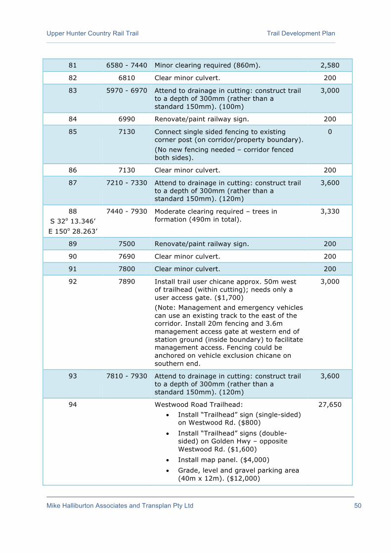
Upper Hunter Country Rail Trail Trail Development Plan
Mike Halliburton Associates and Transplan Pty Ltd 50
81 6580 - 7440 Minor clearing required (860m). 2,580
82 6810 Clear minor culvert. 200
83 5970 - 6970 Attend to drainage in cutting: construct trail to a depth of 300mm (rather than a standard 150mm). (100m)
3,000
84 6990 Renovate/paint railway sign. 200
85 7130 Connect single sided fencing to existing corner post (on corridor/property boundary). (No new fencing needed – corridor fenced both sides).
0
86 7130 Clear minor culvert. 200
87 7210 - 7330 Attend to drainage in cutting: construct trail to a depth of 300mm (rather than a standard 150mm). (120m)
3,600
88 S 32o 13.346’ E 150o 28.263’
7440 - 7930 Moderate clearing required – trees in formation (490m in total).
3,330
89 7500 Renovate/paint railway sign. 200
90 7690 Clear minor culvert. 200
91 7800 Clear minor culvert. 200
92 7890 Install trail user chicane approx. 50m west of trailhead (within cutting); needs only a user access gate. ($1,700) (Note: Management and emergency vehicles can use an existing track to the east of the corridor. Install 20m fencing and 3.6m management access gate at western end of station ground (inside boundary) to facilitate management access. Fencing could be anchored on vehicle exclusion chicane on southern end.
3,000
93 7810 - 7930 Attend to drainage in cutting: construct trail to a depth of 300mm (rather than a standard 150mm). (120m)
3,600
94 Westwood Road Trailhead: • Install “Trailhead” sign (single-sided)
on Westwood Rd. ($800) • Install “Trailhead” signs (double-
sided) on Golden Hwy – opposite Westwood Rd. ($1,600)
• Install map panel. ($4,000) • Grade, level and gravel parking area
(40m x 12m). ($12,000)
27,650
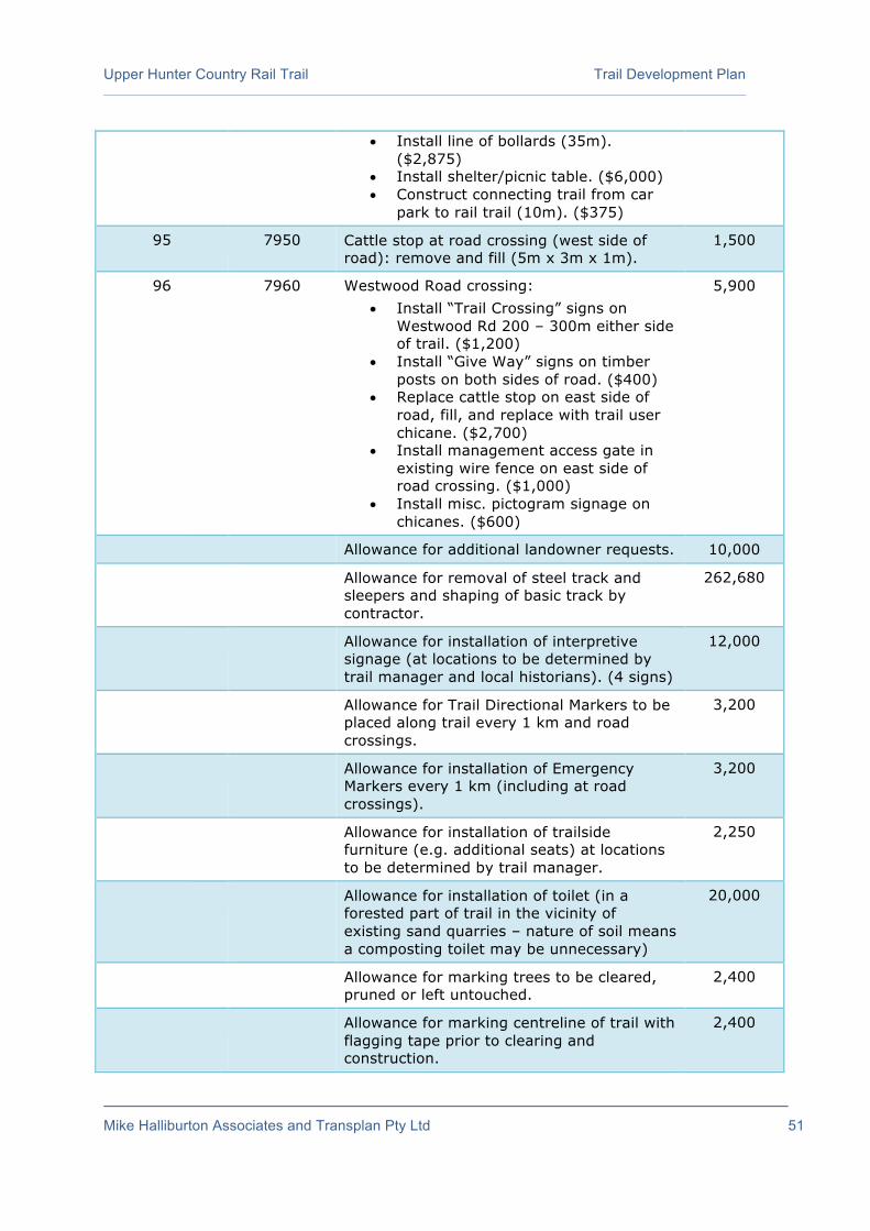
Upper Hunter Country Rail Trail Trail Development Plan
Mike Halliburton Associates and Transplan Pty Ltd 51
• Install line of bollards (35m). ($2,875)
• Install shelter/picnic table. ($6,000) • Construct connecting trail from car
park to rail trail (10m). ($375)
95 7950 Cattle stop at road crossing (west side of road): remove and fill (5m x 3m x 1m).
1,500
96 7960 Westwood Road crossing: • Install “Trail Crossing” signs on
Westwood Rd 200 – 300m either side of trail. ($1,200)
• Install “Give Way” signs on timber posts on both sides of road. ($400)
• Replace cattle stop on east side of road, fill, and replace with trail user chicane. ($2,700)
• Install management access gate in existing wire fence on east side of road crossing. ($1,000)
• Install misc. pictogram signage on chicanes. ($600)
5,900
Allowance for additional landowner requests. 10,000
Allowance for removal of steel track and sleepers and shaping of basic track by contractor.
262,680
Allowance for installation of interpretive signage (at locations to be determined by trail manager and local historians). (4 signs)
12,000
Allowance for Trail Directional Markers to be placed along trail every 1 km and road crossings.
3,200
Allowance for installation of Emergency Markers every 1 km (including at road crossings).
3,200
Allowance for installation of trailside furniture (e.g. additional seats) at locations to be determined by trail manager.
2,250
Allowance for installation of toilet (in a forested part of trail in the vicinity of existing sand quarries – nature of soil means a composting toilet may be unnecessary)
20,000
Allowance for marking trees to be cleared, pruned or left untouched.
2,400
Allowance for marking centreline of trail with flagging tape prior to clearing and construction.
2,400

Upper Hunter Country Rail Trail Trail Development Plan
Mike Halliburton Associates and Transplan Pty Ltd 52
Allowance for survey costs (for new or reinstated fencing) (7,630m)
38,150
Allowance for cable locator 2,000
Allowance for engineering assessment Wappinguy Siding timber bridge
5,000
Allowance for traffic management (Westwood Rd)
2,000
Allowance for purchase and installation of: • Regulatory signage (Shared Path; “No
Trail Bikes”; “Authorised Users Only”); • Road name signs; • Trail name signs; • “No Trespassing” signs; • Local attractions signs; • Miscellaneous signs (Bridge loading;
Keep Out etc.)
1,200
Option A: Sub-total (Section 2) 1,177,500
Option B: Sub-total (Section 2) 1,193,420
Option C: Sub-total (Section 2) 1,183,200
Option D: Sub-total (Section 2) (maximum estimated expenditure)
1,198,820
Approvals, permits, applications, designs, specifications, assessments (2.5% of maximum estimated expenditure – $1,198,820)
29,970
Contingency amount (7.5% of maximum estimated expenditure – $1,198,820)
89,910
Project management (5% of maximum estimated expenditure – $1,198,820)
59,940
TOTAL (NOT INCLUDING GST) 1,378,640 Option A: walker/cyclist trail; no separate bridle trail – no additional chicane
systems at property boundaries (noted in italics)
Option B: walker/cyclist trail; separate bridle trail – no additional chicane systems at property boundaries (noted in italics)
Option C: walker/cyclist trail; no separate bridle trail – all additional chicane systems at property boundaries (noted in italics)
Option D: walker/cyclist trail; separate bridle trail – all additional chicane systems at property boundaries (noted in italics). Option D represents the maximum estimated expenditure.

Upper Hunter Country Rail Trail Trail Development Plan
Mike Halliburton Associates and Transplan Pty Ltd 53
Table 3: Westwood Rd – Gungal Trailhead (7,590m)
Ref # (GPS ref if applicable)
Dist. from beginning
(m)
Works Item $
1 0 - 7590 Construct trail between Westwood Rd and Gungal (7,590m). Slash and flail bridle trail alongside main trail (if horses are to be permitted) (7,590m)
455,400
15,180
2 0 - 340 Install single sided fencing on northern side (340m in total).
5,100
3 0 - 130 Moderate clearing – trees on formation (130m in total).
880
4 55 Renovate/paint railway sign. 200
5 80 Clear minor culvert. 200
6 130 - 2450 Minor clearing required (2320m). 6,960
7 340 – 660 Install double sided fencing (640m in total). The existing side fence on the south side is some distance from formation; the corridor may be as wide as currently fenced (in which case no fencing is needed on this side) or a new fence may need to be constructed on boundary closer to formation.
9,600
8 S 32o 13.471’ E 150o 28.838’
580 Renovate/paint railway sign. 200
9 660 - 2130 Install single sided fencing on northern side (1470m in total).
22,050
10 760 Clear minor culvert. 200
11 880 - 970 Attend to drainage in cutting: construct trail to a depth of 300mm (rather than a standard 150mm). (90m).
2,700
12 990 – 1070 Attend to drainage in cutting: construct trail to a depth of 300mm (rather than a standard 150mm). (80m).
2,400
13 1090 Renovate/paint railway sign. 200
14 1510 Clear medium culvert. ($300) Erect 10 m post and rail barrier on both sides (20m in total). ($2,000)
2,300
15 1600 Renovate/paint railway sign. 200

Upper Hunter Country Rail Trail Trail Development Plan
Mike Halliburton Associates and Transplan Pty Ltd 54
16 1660 Cattle stop: Remove and install pipe and fill over 8m x 3m x 1m deep ($1,500). Install management access gate in existing cross fence (existing management access gate in fence on northern side likely to be outside corridor). ($1,000) Lot boundary: possible property boundary. If property boundary (determine in consultation with landowner), install chicane system (similar to road crossing) to prevent livestock movement.
2,500
2,700
17 1710 – 2080
Attend to drainage in cutting: construct trail to a depth of 300mm (rather than a standard 150mm). (370m). (Note – missing rail for this 370m).
11,100
18 2120 Livestock/machinery crossing point. Install Type B (trail open 24/7) crossing.
3,800
19 2130 Cattle stop: Remove and install pipe and fill over (6m x 3m x 1m deep).
1,500
20 2130 – 2250
Install double sided fencing (240m in total). 3,600
21 2140 Renovate/paint railway sign. 200
22 S 32o 14.044’ E 150o 29.193’
2190 Trim but retain she-oaks. 300
23 S 32o 14.065’ E 150o 29.172’
2240 Remove tree – grown around formation. 700
24 S 32o 14.070’ E 150o 29.167’
2250 – 2450
Install single sided fencing on western side (200m in total). ($3,000) Erect 30 m post and rail barrier starting at 2260 – both sides (60 m in total). ($6,000)
9,000
25 2270 Clear minor culvert. 200
26 2320 – 2390
Erect 70 m post and rail barrier on eastern side (70 m in total).
7,000
27 S 32o 14.145’ E 150o 29.142’
2440 Trim but retain tree. 200
28 2450 – 2590
Attend to drainage in cutting: construct trail to a depth of 300mm (rather than a standard 150mm). (140m). ($4,200)
9,200

Upper Hunter Country Rail Trail Trail Development Plan
Mike Halliburton Associates and Transplan Pty Ltd 55
Geotechnical engineer to check stability of cutting. ($2,000) Rock removal in cutting required. ($3,000)
29 2450 – 2650
Moderate clearing – trees on formation (140m in total).
950
30 2650 – 7590
2650
Minor clearing required (4940m). ($14,820) Remove cattle stop. ($300) Install 5m Landmark (or similar) bridge. ($20,000) Lot boundary: possible property boundary. If property boundary (determine in consultation with landowner), install chicane system (similar to road crossing) to prevent livestock movement.
35,120
2,700
31 2710 Renovate/paint railway sign. 200
32 2890 Driveway crossing: Install Give Way sign on trail.
200
33 2930 Property boundary: Install 5m Landmark (or similar) bridge on eastern side. ($20,000) Install chicane system on eastern side. ($2,700) Install management access gate in existing fence on eastern side of chicane. ($1,000)
23,700
34 2930 - 3120
New fence required on eastern side. New fence required potentially on western side if property owner wants to retain use of what appears to be rail corridor and road corridor (assume double fencing required – 380m in total).
5,700
35 3125 Install 8m Landmark (or similar) bridge. 32,000
36 3130 - 3420
New fence required on eastern side. New fence required potentially on western side if property owner wants to retain use of what appears to be rail corridor and road corridor (assume double fencing required – 580m in total).
8,700
37 3230 Renovate/paint railway sign. 200
38 3310 Lot boundary: possible property boundary. If property boundary (determine in consultation with landowner), install chicane system (similar to road crossing) to prevent livestock movement.
2,700
39 3400 Temporary electric fence (at July 2016). 0

Upper Hunter Country Rail Trail Trail Development Plan
Mike Halliburton Associates and Transplan Pty Ltd 56
40 3420 Driveway crossing: Install chicane system (similar to road crossing) to prevent livestock movement. Install double sided fence (880m in total).
5,400
13,200
41 3435 Temporary electric fence (at July 2016). 0
42 3520 Remove cross fence. 200
43 3610 Old bridge: Remove and replace with culvert.
3,500
44 3840 Remove cross fence. Landholder has incorporated this stretch of corridor (80m to Works Item 44) into a bigger fenced paddock.
200
45 3840 – 4160
Install double sided fencing (640m in total). 9,600
46 S 32o 14.857’ E 150o 29.299’
3920 Clear minor culvert. 200
47 3920 Remove cross fence. 200
48 4030 – 4150
Attend to drainage in cutting: construct trail to a depth of 300mm (rather than a standard 150mm). (120m)
3,600
49 4160 - 4470
Install single sided fencing on western side (310m in total).
4,650
50 S 32o 14.947’ E 150o 29.426’
4190 Livestock/machinery crossing point: Install Type A (open to livestock 24/7) crossing.
3,800
51 4470 Lot boundary: possible property boundary. If property boundary (determine in consultation with landowner), install chicane system (similar to road crossing) to prevent livestock movement.
2,700
52 4480 - 4700
Install single sided fencing on eastern side (220m in total). ($3,300) Install access gate and 5m fencing on western side. ($1,075)
4,375
53 4700 Remove existing small bridge. ($750) Install 7m Landmark (or similar) bridge. ($28,000)
28,750
54 4730 - 5250
Install new double sided fencing (1040m in total). (Existing fences in bad repair).
15,600

Upper Hunter Country Rail Trail Trail Development Plan
Mike Halliburton Associates and Transplan Pty Ltd 57
55 S 32o 15.159’ E 150o 29.665’
4850 Stand up and renovate/paint railway sign. 300
56 4930 Clear minor culvert. 200
57 5030 Livestock/machinery crossing point: Install Type A (open to livestock 24/7) crossing.
3,800
58 5250 Driveway crossing. Install chicane system (similar to road crossing) to prevent livestock movement on both sides.
5,400
59 5270 - 6180
Install single sided fencing on western side (910m in total).
13,650
60 5330 Pipe and fill over (4m x 4m x 1m deep). 1,500
61 5390 Renovate/paint railway sign. 200
62 S 32o 15.383’ E 150o 29.863’
5450 Clear minor culvert. 200
63 5750 Remove cross fence. 200
64 S 32o 15.618’ E 150o 29.815’
5900 Renovate/paint railway sign. 200
65 5930 Clear minor culvert. 200
66 6180 Possible livestock/machinery crossing point: Install side gate in new boundary fence opposite existing management access gate (Trail open 24/7). Alternative location for new management access gate is 6262 (80 m further south) – there is also a gate in existing fence.
1,000
67 6180 - 6330
Install single sided fencing on western side (150m in total).
2,250
68 6330 Remove cattle stop. ($300) Install 8m Landmark (or similar) bridge. ($32,000)
32,300
69 6340 - 6760
Install single sided fencing on eastern side (420m in total).
6,300
70 6420 Clear minor culvert. 200
71 6450 Renovate/paint railway sign. 200
72 6640 Install Landmark (or similar) 10m bridge. 40,000
73 6710 Remove cross fence. ($200) 1,200

Upper Hunter Country Rail Trail Trail Development Plan
Mike Halliburton Associates and Transplan Pty Ltd 58
Install management gate in new fence on eastern side. ($1,000) (Utilise existing management gate in existing property fence on western side for livestock/machinery crossing point).
74 6800 Install user access gate attaching it to existing gate in old fence.
500
75 6800 Existing crossing point – no action required. Existing gates in side fences.
0
76 6810 - 7180
Attend to drainage in cutting: construct trail to a depth of 300mm (rather than a standard 150mm). (370m).
11,100
77 6980 Renovate/paint railway sign. 200
78 6890 – 7190
Install double sided fencing (600m in total). 9,000
79 7190 Remove cross fence. ($200) Possible livestock/machinery crossing point: Utilise existing management gate in existing boundary fence (Trail open 24/7). Install new management access gate in new single sided fencing on eastern side. ($1,000)
1,200
80 7190 - 7280
Install single sided fencing on eastern side (90m in total).
1,350
81 7200 Clear minor culvert. 200
82 7280 Lot boundary: possible property boundary. If property boundary (determine in consultation with landowner), install chicane system (similar to road crossing) to prevent livestock movement.
2,700
83 7280 - 7360
Install single sided fencing on eastern side (80m in total).
1,200
84 7280 Possible livestock/machinery crossing point: Install management gate in new fence. Utilise existing management gate on existing fence (Trail open 24/7).
1,000
85 7330 Clear minor culvert. 200
86 7340 - 7500
Allowance for privacy screening vegetation (property owner did not request screening but needed here to protect privacy). Allow 160m (x 3m deep).
960
87 7430 Clear minor culvert. 200
88 7460 Remove cross fence. 200

Upper Hunter Country Rail Trail Trail Development Plan
Mike Halliburton Associates and Transplan Pty Ltd 59
89 7570 Install chicane system (similar to road crossing) in existing cross fence to prevent livestock movement.
2,700
90 7590 Corridor meets access road to Gungal picnic area. Low lying: Install pipe culvert under trail and fill over (15m x 3m).
6,125
91 Gungal Trailhead and Golden Highway crossing:
• Install “Trailhead” sign (single-sided) on Golden Hwy – opposite northern entrance to rest area. ($800)
• Install “Trailhead” sign (single-sided) on Golden Hwy – opposite southern entrance to rest area. ($800)
• Install “Trail Crossing” signs on Golden Highway 100 – 200m either side of trail. ($1,200)
• Install map panel. ($4,000) • Construct new trail to proposed road
crossing (55m). ($2,065) • Install “Stop” signs on trail either
side of highway crossing. ($400) • Install Trail Directional Markers in
accordance with site plan. ($1,200)
10,465
Allowance for additional landowner requests.
10,000
Allowance for removal of steel track and sleepers and shaping of basic track by contractor.
250,470
Allowance for installation of interpretive signage (at locations to be determined by trail manager and local historians). (4 signs).
12,000
Allowance for Trail Directional Markers to be placed along trail every 1 km and road crossings.
3,200
Allowance for installation of Emergency Markers every 1 km (including at road crossings).
3,200
Allowance for installation of trailside furniture (e.g. additional seats) at locations to be determined by trail manager.
3,000
Allowance for marking trees to be cleared, pruned or left untouched.
2,400
Upper Hunter Country Rail Trail Trail Development Plan
Mike Halliburton Associates and Transplan Pty Ltd 60
Allowance for marking centreline of trail with flagging tape prior to clearing and construction.
2,400
Allowance for survey costs (for new or reinstated fencing). (9,100m)
45,500
Allowance for cable locator. 2,000
Allowance for traffic management (Gungal Rest Area access road).
2,000
Allowance for purchase and installation of: • Regulatory signage (Shared Path; “No
Trail Bikes”; “Authorised Users Only”); • Road name signs; • Trail name signs; • “No Trespassing” signs; • Local attractions signs; • Miscellaneous signs (Bridge loading;
Keep Out etc.)
1,200
Option A: Sub-total (Section 3) 1,251,565
Option B: Sub-total (Section 3) 1,266,745
Option C: Sub-total (Section 3) 1,265,065
Option D: Sub-total (Section 3) 1,280,245
Approvals, permits, applications, designs, specifications, assessments (2.5% of maximum estimated expenditure – $1,280,245
32,005
Contingency amount (7.5% of maximum estimated expenditure – $1,280,245
96,020
Project management (5% of maximum estimated expenditure – $1,280,245
64,010
TOTAL (NOT INCLUDING GST) 1,472,280 Option A: walker/cyclist trail; no separate bridle trail – no additional chicane
systems at property boundaries (noted in italics)
Option B: walker/cyclist trail; separate bridle trail – no additional chicane systems at property boundaries (noted in italics)
Option C: walker/cyclist trail; no separate bridle trail – all additional chicane systems at property boundaries (noted in italics)
Option D: walker/cyclist trail; separate bridle trail – all additional chicane systems at property boundaries (noted in italics). Option D represents the maximum estimated expenditure.

Upper Hunter Country Rail Trail Trail Development Plan
Mike Halliburton Associates and Transplan Pty Ltd 61
Table 4: Gungal Trailhead – Sandy Hollow Trailhead (7,590m)
Ref #
(GPS ref if applicable)
Dist. from beginning
(m)
Works Item $
0 South side of Golden Highway.
1 0 – 12335 Construct trail between Gungal and Sandy Hollow – Goulburn Drive (11,605m).
696,300
Slash and flail bridle trail alongside main trail (if horses are to be permitted) (11,605m).
23,210
2 0 - 40 Construct new trail (clearing and fill required) from road edge to existing cross fence (40m). Create access through cross fence (a simple opening is all that is needed).
6,875
3 40 - 1840 140
Minor clearing required (1800m in total). ($5,400) Clear minor culvert. ($200) Install “Road Ahead” sign on trail. ($200)
5,600
4 280 - 370 Attend to drainage in cutting: construct trail to a depth of 300mm (rather than a standard 150mm). (90m).
2,700
5 400 Install user access gate in existing fence (revegetation project).
500
6 400 - 530 Revegetated area. 0
7 530 Install user access gate in existing fence (revegetation project).
500
8 800 Cattle stop: remove, install pipe and fill over. 1,500
9 800 – 1430
Install single sided fencing on western side (630m in total). Fence may also be needed between the trail and Worondi Creek Rd in this section – this addition is not costed. If double sided fencing installed, install user access gate in new cross fence (to prevent cattle getting onto the corridor).
9,450
10 870 Renovate/paint railway sign. 200
11 900 Clear minor culvert. 200
12 960 Livestock/machinery crossing point: Install new management gate in new fence on western side of trail. (If both sides of trail are fenced as per the note in Works Item 9, install Type B (trail open 24/7) crossing – this item is uncosted)
1,000

Upper Hunter Country Rail Trail Trail Development Plan
Mike Halliburton Associates and Transplan Pty Ltd 62
13 S 32o 17.054’ E 150o 30.400’
1260 Install small pipe under formation. 500
14 1340 Renovate/paint railway sign. 200
15 1430 Cattle stop: Remove and install pipe and fill over (4m x 4m x 1m). If double sided fencing installed (Works Item 9), install user access gate in cross fence (to prevent cattle getting onto the corridor) – uncosted.
1,500
16 1640 Install 6m Landmark (or similar) bridge. 24,000
17 S 32o 17.347’ E 150o 30.463’
1840 Worondi Creek Rd crossing: • Install “Trail Crossing” signs on
Worondi Creek Rd 200 – 300m either side of trail. ($1,200)
• Install “Give Way” signs on timber posts on both sides of road ($400)
• Install misc. pictogram signage on timber posts. ($600)
2,200
18 1840 - 2205
Minor clearing required (360m in total). 1,095
19 2160 Property boundary: Remove old bridge. Install new 6m Landmark (or similar) bridge ($24,000) Install chicane system (similar to road crossing) to prevent livestock movement. ($2,700)
26,700
20 2160 - 2700
Install single sided fencing on eastern side (540m in total).
8,100
21 2205 -2700 Moderate clearing – trees on formation (490m in total).
3,330
22 S 32o 17.632’ E 150o 30.490’
2394 Renovate/paint railway sign. 200
23 2700 - 6025
Install double sided fencing (6660 m in total). Attach fencing to roadside fencing on western side.
99,750
24 2700 - 6370
Minor clearing required (3670m in total). 11,010
25 2700 - 2920
Allowance for privacy screening vegetation (property owner did not request screening but needed here to protect privacy). Allow 220m (x 3m deep).
1,320

Upper Hunter Country Rail Trail Trail Development Plan
Mike Halliburton Associates and Transplan Pty Ltd 63
26 2820 Livestock/machinery crossing point: Install Type A (open to livestock 24/7) crossing.
3,800
27 2920 Renovate/paint railway sign. 200
28 2940 Driveway crossing: Install new cross fencing on both sides. Install management access gate and user access gate in new fencing on both sides.
3,460
29 S 32o 18.033’ E 150o 30.640’
3250 Install new 5m Landmark (or similar) bridge. 20,000
30 3370
Cattle stop: Remove and install pipe and fill over (4m x 3m x 1m deep). Lot boundary: possible property boundary. If property boundary (determine in consultation with landowner), install chicane system (similar to road crossing) to prevent livestock movement.
1,500
2,700
31 3470 Renovate/paint railway sign. 200
32 3630 Livestock/machinery crossing point: Install management gate in new fence either side of trail. (Trail open 24/7).
1,000
33 3750 Cattle stop: Remove and install pipe and fill over (4m x 3m x 1m deep). Lot boundary: possible property boundary. If property boundary (determine in consultation with landowner), install chicane system (similar to road crossing) to prevent livestock movement.
1,500
2,700
34 3790
Livestock/machinery crossing point: Install management gate in new fence either side of trail. (Trail open 24/7).
2,000
35 3990
Renovate/paint railway sign. 200
36 4180 Pipe and fill over (4m x 3m x 1m deep). 1,500
37 4190 Cross fence: Pipe and fill over (4m x 3m x 1m deep).
1,500
38 4250 Livestock/machinery crossing point: Install Type A (open to livestock 24/7) crossing.
3,800
39 4430
Install new 5m Landmark (or similar) bridge. 20,000
40 4520
Renovate/paint railway sign. 200

Upper Hunter Country Rail Trail Trail Development Plan
Mike Halliburton Associates and Transplan Pty Ltd 64
41 4640 - 4760
Attend to drainage in cutting: construct trail to a depth of 300mm (rather than a standard 150mm). (120m).
3,600
42 4850
Clear minor culvert. 200
43 4930 Livestock/machinery crossing point: Install management gate in new fence either side of trail. (Trail open 24/7).
2,000
44 5050
Renovate/paint railway sign. 200
45 5380 Remains of cattle stop (assume old property boundary): Pipe and fill over (6m x 6m x 1m deep).
1,500
46 5590 Clear medium culvert. ($300) Erect 10 m post and rail barrier on both sides (20 m in total). ($2,000)
2,300
47 5610 - 5870
Attend to drainage in cutting: construct trail to a depth of 300mm (rather than a standard 150mm). (260m)
7,800
48 5730 Livestock/machinery crossing point: Install management gate in new fence either side of trail. (Trail open 24/7). (This crossing could possibly be relocated to the end of the cutting at 6600).
2,000
49 5830 Renovate/paint railway sign. 200
50 5870 Alternative crossing point to #48. 0
51 6020 Install new 5m Landmark (or similar) bridge. 20,000
52 6025 - 8240
Install single sided fencing on eastern side (2210m in total).
33,150
53 6290 Livestock/machinery crossing point: Install management gate in fence either side of trail. (Trail open 24/7).
2,000
54 S 32o 19.167’ E 150o 31.552’ (northern take-
off point) S 32o 19.180’ E 150o 31.550’ (southern take-
off point)
6370 Install new 30m steel truss bridge.
174,000
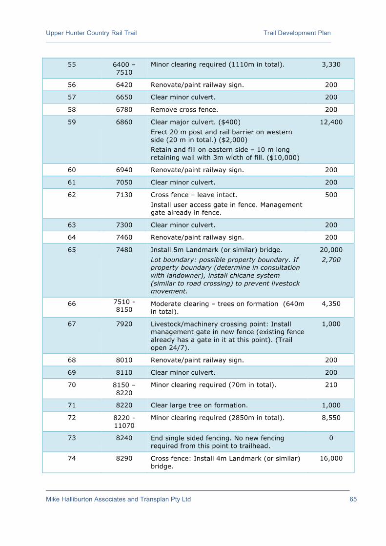
Upper Hunter Country Rail Trail Trail Development Plan
Mike Halliburton Associates and Transplan Pty Ltd 65
55 6400 – 7510
Minor clearing required (1110m in total). 3,330
56 6420 Renovate/paint railway sign. 200
57 6650 Clear minor culvert. 200
58 6780 Remove cross fence. 200
59 6860 Clear major culvert. ($400) Erect 20 m post and rail barrier on western side (20 m in total.) ($2,000) Retain and fill on eastern side – 10 m long retaining wall with 3m width of fill. ($10,000)
12,400
60 6940 Renovate/paint railway sign. 200
61 7050 Clear minor culvert. 200
62 7130 Cross fence – leave intact. Install user access gate in fence. Management gate already in fence.
500
63 7300 Clear minor culvert. 200
64 7460 Renovate/paint railway sign. 200
65 7480 Install 5m Landmark (or similar) bridge. Lot boundary: possible property boundary. If property boundary (determine in consultation with landowner), install chicane system (similar to road crossing) to prevent livestock movement.
20,000 2,700
66 7510 - 8150
Moderate clearing – trees on formation (640m in total).
4,350
67 7920 Livestock/machinery crossing point: Install management gate in new fence (existing fence already has a gate in it at this point). (Trail open 24/7).
1,000
68 8010 Renovate/paint railway sign. 200
69 8110 Clear minor culvert. 200
70 8150 – 8220
Minor clearing required (70m in total). 210
71 8220 Clear large tree on formation. 1,000
72 8220 - 11070
Minor clearing required (2850m in total). 8,550
73 8240 End single sided fencing. No new fencing required from this point to trailhead.
0
74 8290 Cross fence: Install 4m Landmark (or similar) bridge.
16,000

Upper Hunter Country Rail Trail Trail Development Plan
Mike Halliburton Associates and Transplan Pty Ltd 66
75 8460 Install low level 4m Landmark (or similar) bridge. No handrails needed (install with fall to ground less than 1 metre).
12,000
76 8540 Livestock/machinery crossing point: Install management gates in existing side fences (Trail open 24/7).
2,000
77 8550 Renovate/paint railway sign. 200
78 8790 Install 10m Landmark (or similar) bridge (and user access gates on both approaches).
41,000
79 8900 Clear minor culvert. 200
80 9050 Renovate/paint railway sign. 200
81 9060 Driveway crossing. Management gates in place in existing side fences. Install fence across corridor on both sides with management gate and user access gate in new fences.
3,460
82 9090 Clear minor culvert. 200
83 9110 – 9390
Attend to drainage in cutting: construct trail to a depth of 300mm (rather than a standard 150mm). (280m).
8,400
84 9400 Install user access gate in existing cross fence (management gate already exists).
500
85 9440 Clear minor culvert. 200
86 9510 – 9610
Attend to drainage in cutting: construct trail to a depth of 300mm (rather than a standard 150mm). (100m).
3,000
87 9580 Renovate/paint railway sign (on top of cutting).
200
88 9660 Clear minor culvert. 200
89 9730 Livestock/machinery crossing point: Install cross fence, management gate and user access gate on western side.
1,730
90 9750 Pipe and fill over (6m x 3m x 1m deep). ($1,500) Install management gate and user access gate on eastern side. ($1,500)
3,000
91 9750 – 10910
Install double sided fencing close to trail (2320m in total).
34,800
92 9990 Clear minor culvert. 200
93 10180 Clear minor culvert. 200
94 10330 Livestock/machinery crossing point. Install Type B (trail open 24/7) crossing.
3,800
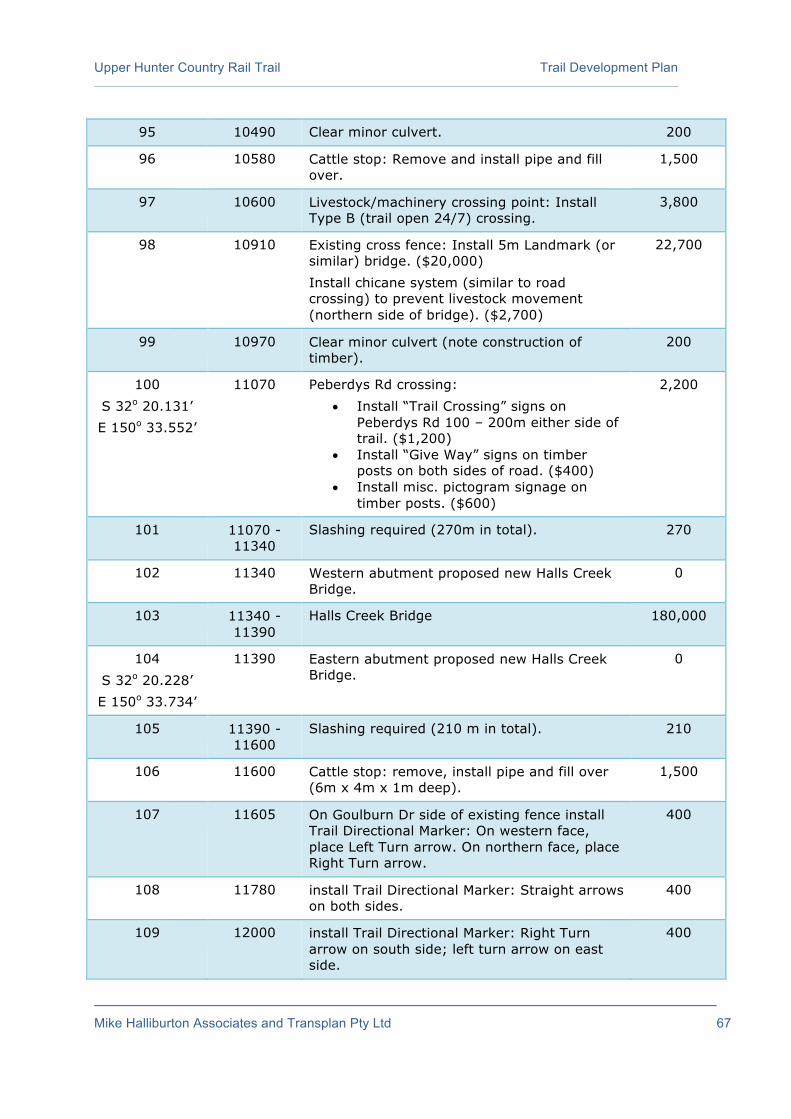
Upper Hunter Country Rail Trail Trail Development Plan
Mike Halliburton Associates and Transplan Pty Ltd 67
95 10490 Clear minor culvert. 200
96 10580 Cattle stop: Remove and install pipe and fill over.
1,500
97 10600 Livestock/machinery crossing point: Install Type B (trail open 24/7) crossing.
3,800
98 10910 Existing cross fence: Install 5m Landmark (or similar) bridge. ($20,000) Install chicane system (similar to road crossing) to prevent livestock movement (northern side of bridge). ($2,700)
22,700
99 10970 Clear minor culvert (note construction of timber).
200
100 S 32o 20.131’ E 150o 33.552’
11070 Peberdys Rd crossing: • Install “Trail Crossing” signs on
Peberdys Rd 100 – 200m either side of trail. ($1,200)
• Install “Give Way” signs on timber posts on both sides of road. ($400)
• Install misc. pictogram signage on timber posts. ($600)
2,200
101 11070 - 11340
Slashing required (270m in total). 270
102 11340 Western abutment proposed new Halls Creek Bridge.
0
103 11340 - 11390
Halls Creek Bridge 180,000
104 S 32o 20.228’ E 150o 33.734’
11390 Eastern abutment proposed new Halls Creek Bridge.
0
105 11390 - 11600
Slashing required (210 m in total). 210
106 11600 Cattle stop: remove, install pipe and fill over (6m x 4m x 1m deep).
1,500
107 11605 On Goulburn Dr side of existing fence install Trail Directional Marker: On western face, place Left Turn arrow. On northern face, place Right Turn arrow.
400
108 11780 install Trail Directional Marker: Straight arrows on both sides.
400
109 12000 install Trail Directional Marker: Right Turn arrow on south side; left turn arrow on east side.
400

Upper Hunter Country Rail Trail Trail Development Plan
Mike Halliburton Associates and Transplan Pty Ltd 68
110 12030 Sandy Hollow trailhead: • Install “Trailhead” signs (double-sided)
on Golden Hwy – on south side of road near to rest area. ($1,600)
• Install map panel. ($4,000)
5,600
Allowance for additional landowner requests. 10,000
Allowance for removal of steel track and sleepers and shaping of basic track by contractor.
396,990
Allowance for installation of interpretive signage (at locations to be determined by trail manager and local historians). (6 signs)
18,000
Allowance for Trail Directional Markers to be placed along trail every 1 km and road crossings.
6,600
Allowance for installation of Emergency Markers every 1 km (including at road crossings).
4,800
Allowance for installation of trailside furniture (e.g. additional seats) at locations to be determined by trail manager.
4,500
Allowance for marking trees to be cleared, pruned or left untouched.
3,600
Allowance for marking centreline of trail with flagging tape prior to clearing and construction.
3,600
Allowance for survey costs (for new or reinstated fencing). (10,040m)
50,200
Allowance for engineering assessment Halls Creek bridge
10,000
Allowance for cable locator 2,000
Allowance for traffic management (Golden Highway, Worondi Creek Rd, Peberdys Rd)
8,000
Allowance for purchase and installation of: • Regulatory signage (Shared Path; “No Trail
Bikes”; “Authorised Users Only”); • Road name signs; • Trail name signs; • “No Trespassing” signs; • Local attractions signs; • Miscellaneous signs (Bridge loading; Keep
Out etc.)
1,200
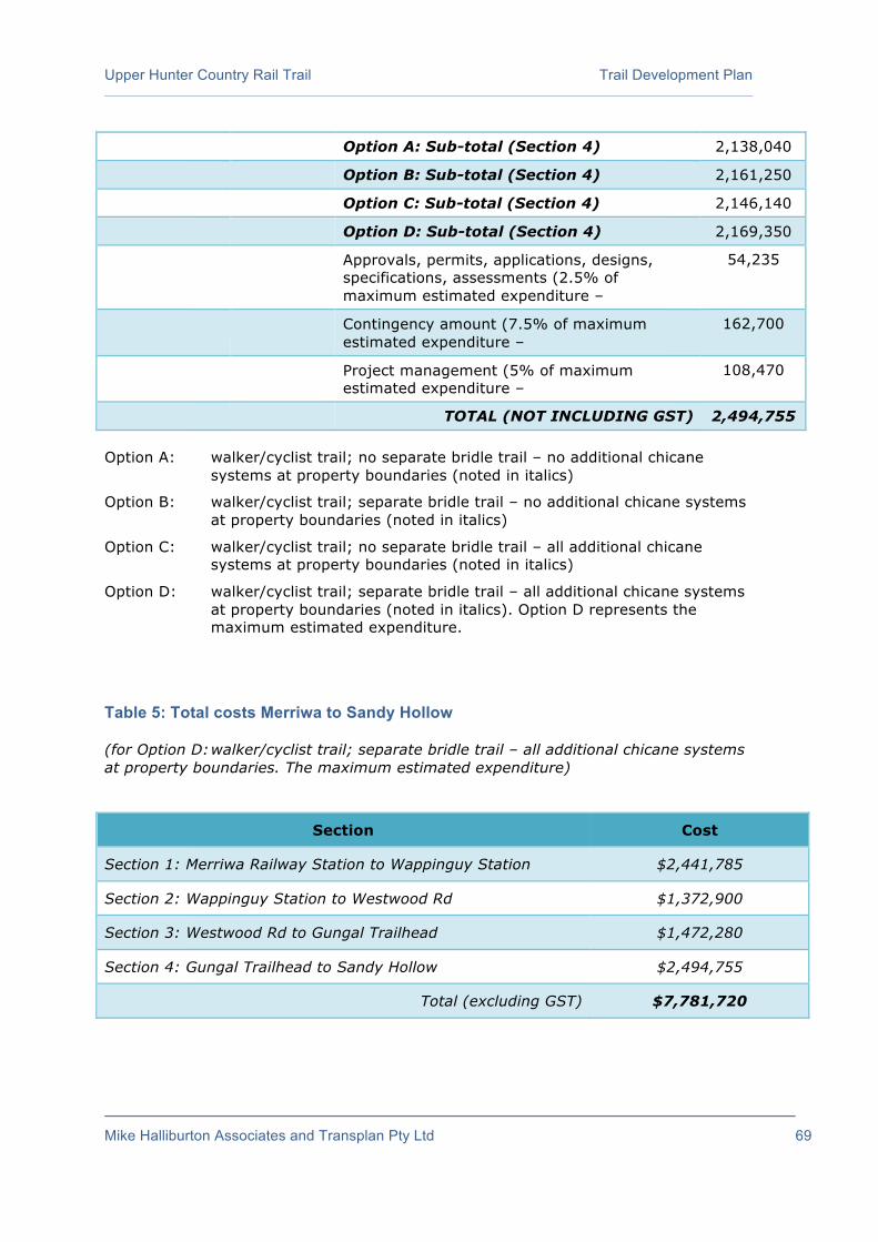
Upper Hunter Country Rail Trail Trail Development Plan
Mike Halliburton Associates and Transplan Pty Ltd 69
Option A: Sub-total (Section 4) 2,138,040
Option B: Sub-total (Section 4) 2,161,250
Option C: Sub-total (Section 4) 2,146,140
Option D: Sub-total (Section 4) 2,169,350
Approvals, permits, applications, designs, specifications, assessments (2.5% of maximum estimated expenditure –
54,235
Contingency amount (7.5% of maximum estimated expenditure –
162,700
Project management (5% of maximum estimated expenditure –
108,470
TOTAL (NOT INCLUDING GST) 2,494,755 Option A: walker/cyclist trail; no separate bridle trail – no additional chicane
systems at property boundaries (noted in italics)
Option B: walker/cyclist trail; separate bridle trail – no additional chicane systems at property boundaries (noted in italics)
Option C: walker/cyclist trail; no separate bridle trail – all additional chicane systems at property boundaries (noted in italics)
Option D: walker/cyclist trail; separate bridle trail – all additional chicane systems at property boundaries (noted in italics). Option D represents the maximum estimated expenditure.
Table 5: Total costs Merriwa to Sandy Hollow (for Option D: walker/cyclist trail; separate bridle trail – all additional chicane systems at property boundaries. The maximum estimated expenditure)
Section Cost
Section 1: Merriwa Railway Station to Wappinguy Station $2,441,785
Section 2: Wappinguy Station to Westwood Rd $1,372,900
Section 3: Westwood Rd to Gungal Trailhead $1,472,280
Section 4: Gungal Trailhead to Sandy Hollow $2,494,755
Total (excluding GST) $7,781,720
Upper Hunter Country Rail Trail Trail Development Plan
Mike Halliburton Associates and Transplan Pty Ltd 70
4.6 Extension to Denman
The Feasibility Study (2015) recommended the promotion of a signposted on-road cycle route utilising quiet ‘backroads’ (Bylong Valley Road and Yarrawa Road) to extend the rail trail beyond Sandy Hollow to Denman. The Feasibility Study arrived at this recommendation after investigating three options – using the active railway corridor, using the Golden Highway and Rosemount Road, and using the Bylong Valley Rd and Yarrawa Rd. The Study noted that the development of a signposted on-road trail will add to the general appeal of both the rail trail and the general destination of Denman-Sandy Hollow-Merriwa (at relatively low cost). The Study noted that, apart from the Golden Highway, this route uses low traffic volume roads. As a signposted cycle route, it will appeal to a small section of the market likely to be drawn to the proposed rail trail.
Importantly, the Feasibility Study also noted that user numbers are likely to decrease once trail users have finished riding from Merriwa to Sandy Hollow – due to both cumulative distance and user desires for safe off-road environments. It is likely that only a limited number of rail trail users will opt to ride the additional 28 kilometres into Denman. A trail beside the roads is not practical given the long length and high construction costs.
The Feasibility Study recommended that the route should be developed as a signposted, on-road cycle touring route only (i.e. no segregated trail beside the road) at an estimated cost of $80,500 (with most of the costs being absorbed by improvements for Yarrawa Rd).
The brief for the Trail Development Plan included further investigation of the possible connection from Sandy Hollow to Denman. Investigations carried out included a meeting with representatives of the Denman Men’s Shed which discussed the proposal in general, the possibility of locating a trailhead in the vicinity of the Men’s Shed, and general opportunities provided by the rail trail development.
The three route options canvassed in the Feasibility Study were again investigated and there was no new evidence that the recommended route should be changed.
A further option utilising Richmond Grove Road which would take users along the Golden Highway and the Bylong Valley Way before turning east on Richmond Grove Road and linking with Rosemount Rd east of the Hunter River was also investigated.
There are two key issues in considering this option:
Land tenure
River crossing
Land Tenure
Existing mapping shows that Richmond Grove Road finishes as a public road at Richmond Grove Farm. Investigation of aerial photography shows the formed road finishing between farm buildings (including what looks like the farm house). Use of SixMaps (a NSW Government online mapping resource) does show what appears to be a road reserve running to the western bank of the Hunter River but the status of this
Upper Hunter Country Rail Trail Trail Development Plan
Mike Halliburton Associates and Transplan Pty Ltd 71
reserve is not clear. On-site investigation in November 2016 encountered a locked gate barring access along Richmond Grove Rd (approximately 3kms from the intersection of Richmond Grove Rd and Bylong Valley Way). If it is a road reserve to the river, it should allow public access. It would however seem to be problematic given the closeness to farm buildings and the farm use of the road reserve between the farm buildings and the river. While it could be argued that the road reserve (if it exists) is similar to the railway corridor, a railway corridor is clearly publicly owned land while an unformed road reserve may be perceived differently by the owner of adjoining parcels of land.
On the eastern bank of the Hunter River, there also appears to be road reserve. Providing public access for this sections seems far less problematic as it is land that appears to not be as actively farmed (and is a much shorter length).
River Crossing
The other critical issue is crossing the Hunter River. A significant span of bridge would be required to provide a good level of flood immunity and financial sustainability (i.e. providing a bridge that does not have to be rebuilt after every minor flood). It is not acceptable in a trail development of this type to simply allow users to travel across the river at bed level. A bridge would need to be built. The bridge over the Hunter River further upstream at the Bylong Valley Way is approximately 180 metres long, while a similar bridge further downstream on Yarrawa Rd is approximately 150 metres long. A bridge to allow cyclists to cross the river in the vicinity of Richmond Grove Road is likely to be of a similar distance. If a similar distance to the existing bridges is assumed, the cost of provision would be around $870,000 – this would allow for the construction of 150 metre steel truss bridge similar to that proposed for the rail trail west of Sandy Hollow (which is costed at $5,800/lineal metre). This cost may rise depending on whether piles need to be driven into the river to support such a large span. Such a span would allow for an “elevated bridge” i.e. one that takes off and lands on high ground (the bridge cannot cross just above the waterline as it will wash away in even minor floods).
There would also be additional costs associated with developing a suitable trail surface on the road reserve. It is not known how much new trail would need to be built (a bitumen seal road runs for some distance along Richmond Grove Road but aerial photography indicates gravel farm access roads to the existing buildings and no road surface between the farm buildings and the river). Any new trail would need to be compatible with the rail trail surface and this cost would be of the order of $61,000 - $64,000/km (depending on the level of clearing needed).
It is likely there would need to be additional fencing and gating systems to manage interactions with farming practices on the western side of the river.
It is difficult to recommend the expenditure of this amount given the likely drop-off in user numbers once users finish on the rail trail at Sandy Hollow (for reasons explored in the 2015 Feasibility Study).
Regardless of the option chosen, there remains the key issue that the extension will only attract experienced cycle tourists rather than less experienced rail trail users,

Upper Hunter Country Rail Trail Trail Development Plan
Mike Halliburton Associates and Transplan Pty Ltd 72
given the distance and the safety issues associated with riding on roads (even though they may be lightly trafficked).
It is likely that many of the economic benefits identified in the Feasibility Study arising from the rail trail development will accrue to Denman as the key accommodation provider. As the “tourism hub” in the rail trail locality, it is also likely that many associated support services (such as a bike bus) will operate out of Denman. Experienced touring cyclists will feel comfortable riding on Bylong Valley Road and Yarrawa Road after completing the rail trail. No work is needed on the physical connection itself (over and above any road widening works already planned by Muswellbrook Shire Council for other purposes). All promotional literature for the rail trail should include notes that users can continue to ride from Sandy Hollow to Denman via the Bylong Valley and Yarrawa Roads (the link could be shown as a dotted line on any associated mapping). The literature should clearly identify that it is an on-road cycle touring route suitable for experienced cycle tourists. This approach removes the need to develop a specific dedicated trailhead at Denman but all information material for Denman (brochures, website, information bays, any relevant new developments) should refer to the rail trail and how it can be accessed.
It is recommended that trail directional signage (marker posts, and trail logo and directional arrows on the two relevant post faces) be installed at all decision points (intersections) along the route:
Golden Highway/Bylong Valley Rd
Bylong Valley Rd/Yarrawa Rd
Yarrawa Rd/Yarrawa Deviation Rd
Yarrawa Rd/Virginia St
The estimated cost of this improvement is $1,600.

Upper Hunter Country Rail Trail Trail Development Plan
Mike Halliburton Associates and Transplan Pty Ltd 73
Section 5 – Construction Management
Prior to the construction of the rail trail between Merriwa and Sandy Hollow, the project manager should prepare a Construction Management Plan (CMP).
The purpose of a Construction Management Plan is to provide a framework reference document detailing how the two Councils and their contractors will manage and control aspects of the trail construction. The CMP will be used as a working document to ensure that obligations and commitments provided in the relevant licences, permits and approvals are made known to all site personnel and implemented effectively as an integral part of trail construction.
It also aims to detail processes to minimise impacts associated with the construction of the rail trail on adjacent areas. Given sufficient thought and consideration prior to construction, risks can be mitigated and impacts can be minimised.
Adjoining landowners raised a number of important matters during the consultation phase of this project. These concerns included:
Adjoining landowners are to be advised well in advance of construction activity taking place.
Construction machinery and contractors’ vehicles are not to use private property or private roads to access the former railway corridor (except where permission has been granted). Access should either be along the corridor or adjacent gazetted roads.
Watercourses and creek banks (at the former bridge sites) are not to be damaged during construction as this could have ongoing negative impacts for farmers’ use of those creeks (both on-site and upstream and downstream).
Fencing needs to be maintained at all times during construction to keep stock out of the corridor and gates are to remain closed to prevent stock straying.
Contractors and Council employees are not to trespass on private property during construction (unless prior written agreement is obtained from the landowner).
An ongoing need for crossing the railway corridor from one paddock to another, often at the locations where bridges once were.
Spread of weeds along the corridor by construction machinery is to be controlled and minimised. Vehicle and machinery wash down facilities are needed.
Leaving of rubbish within the corridor during/after construction of the trail should not occur.
Construction crews should work closely with adjoining landowners over various issues, such as water pipes that cross the corridor, location of stock crossings, new fencing etc.

Upper Hunter Country Rail Trail Trail Development Plan
Mike Halliburton Associates and Transplan Pty Ltd 74
The general process for the development of the Upper Hunter Country Rail Trail will involve the following tasks:
Notification of adjoining landowners well in advance of construction commencing.
Ongoing consultation with adjoining landowners to clarify/confirm need for, and precise location of, stock/machinery crossing points (and other matters including privacy screen planting).
Removal of cross fences (including electric fences) where they still exist.
Installation of new side fencing and gates (where required) and/or relocation of existing fencing.
Removal of steel track and sleepers.
Clearing of regrowth vegetation, and removal of weeds.
Construction of stock crossings.
Identification and establishment of stockpile locations and machinery wash down facilities.
Utility identification/relocation (if required).
Environmental and other surveys (e.g. flora if required, site pegging and on ground delineation).
Geotechnical/engineering investigations for drainage crossings.
Replacement/reinstatement (or removal in some instances) of culverts/bridges/cattle stops .
Installation of erosion and sediment controls such as silt fences at waterway crossings.
Haulage/stockpiling of material.
Batter treatment (fill batters if required).
Trail and trailhead base layers and surfacing (compacted gravel for trailheads and rail trail).
Installation of signage (including warning, advisory, trailhead, distance/directional, emergency and interpretive signage).
Installation of management access gates, trail user gates and chicanes and bollards.
Landscaping/revegetation.
Site cleanup.
Consideration will need to be given to the following matters in the preparation of the CMP:

Upper Hunter Country Rail Trail Trail Development Plan
Mike Halliburton Associates and Transplan Pty Ltd 75
Landholder Communication Plan
The Councils should prepare a Landholder Communication Plan before work commences to ensure that all adjacent landowners are aware of the construction program well in advance and are individually consulted regarding exact placement of stock crossings, privacy screen plantings and other matters potentially affecting their farming operations. This includes the early removal of electric fences, cross fences (across the railway corridor), replacement of old cattle stops with fences/gates and the installation of new (or repairs to old) side fences. As noted above, fencing needs to be maintained at all times during construction to keep stock out of the corridor and gates are to remain closed to prevent stock straying.
Safe Work Statement Method (SWMS)
A Safe Work Method Statement (SWMS) documents a process for identifying and controlling health and safety hazards and risks. Under Occupational Health and Safety Regulations, a SWMS must be prepared before high risk construction work begins, if anyone’s health and safety is at risk because of the work, but SWMS can be used for any other work activities. A SWMS is designed to help contractors and their employees think through the hazards and risks involved in the work, and to choose effective control measures. As a matter of course, a SWMS will be required and the CMP must address all risks and address how they will be controlled. Matters to be addressed include construction activity at road crossings and bridge refurbishment (at heights).
Preparation of other Works Method Statements
The appropriate environmental authorities (prior to work commencing) may require several other ‘Works Method Statements’ such as Clearing Work Method Statement, Minor Earth Works Method Statement and Drainage Works Method Statement. These statements will address a range of potential concerns such as the spread of weeds during vegetation clearing (on and offsite), water pollution or sedimentation due to working near to watercourses, and the discovery or impact to any new sites of Aboriginal or non-Aboriginal heritage or archaeological sites.
Environmental and other surveys (e.g. flora if required, site pegging and on ground delineation)
Prior to selection of stockpile sites and construction activity, it may be necessary to carry out a variety of environmental and other surveys. The CMP will need to schedule the activity to occur at appropriate times of the year, and prior to construction.
Geotechnical/engineering investigations for drainage crossings
Various investigations may be required at and around watercourses prior to refurbishment/adaptation of the bridges and culverts. The CMP will need to schedule in this activity prior to construction occurring at these sensitive locations.
Utility identification/relocation (if required)
Fieldwork revealed the existence of some utilities (telecom cabling etc) within the corridor. The CMP should allow for a cable locator to establish the precise locations of utilities and services prior to construction activity (including removal of steel track and sleepers) occurring.

Upper Hunter Country Rail Trail Trail Development Plan
Mike Halliburton Associates and Transplan Pty Ltd 76
Installation of new gates and fences (where required) and stock crossings
In order to ensure stock are kept out of the rail trail corridor, fencing will need to be repaired or relocated or new fencing erected along parts of the corridor. This activity should be undertaken early in the construction process. Cooperation and consultation with adjoining landowners will be required to ensure any new fencing is installed in the appropriate location and that stock crossings are located in the optimum locations.
Fencing and stock control during construction
Construction of the rail trail will mean numerous (existing) fences erected across the corridor (particularly at property boundaries and road crossings) will need to be removed. One of the first steps in construction will be to erect new fences and gates (where appropriate) to ensure stock are contained to their paddocks and to ensure construction machinery have unlimited access along the corridor. The CMP will need to program this activity, including the necessary consultation with adjoining landowners and contractors.
Selection of material stockpile sites
Construction of the rail trail will involve the removal of material from the corridor (discarded timber sleepers, steel, old fencing material, miscellaneous waste/rubbish material) and the delivery of materials to be used in the construction of the trail (gravel, fencing materials, bridge components, etc). Numerous stockpile sites will be required along the alignment to enable the management of gravel surfacing material, bridge/culvert materials, fill and potentially topsoil and vegetation. Care will need to be taken to ensure the selected sites are safely located, secure, and minimise the invasion of the privacy of neighbours of the proposed rail trail. The stockpile sites should also be located on already cleared sites (minimising the vegetation clearing requirements) and with little or no impact on watercourses or other environmentally sensitive sites. It is imperative that access to the corridor be via public land, unless agreement has been obtained from neighbouring landowners. Preparation of the CMP should address these issues.
Remediation of contaminants in sleepers and along formation
Although no contamination investigations are known to have been undertaken, it is possible that there are contaminants in the soil and sleepers from years of maintenance of the railway track, railway corridor and associated infrastructure. The CMP should specify how potential contamination is to be dealt with.
De-contamination of construction equipment
As the rail trail will pass through numerous farming properties, some with bio-security concerns, it is imperative that any construction equipment be kept clean. The CMP should specify the process by which construction equipment will be kept clean of potential diseases, weeds and contaminants.
Management of fire risk (incl. spark control)
There is a risk of accidental fires being caused by sparks from machinery and (in the case of the removal of the steel railway track) the cutting of steel. The CMP will need to address ways of ensuring fires are not inadvertently caused by the construction

Upper Hunter Country Rail Trail Trail Development Plan
Mike Halliburton Associates and Transplan Pty Ltd 77
activity, and consideration given to the time of the year that different construction activities are undertaken. The CMP will identify the general requirements regarding fire prevention and management during construction, especially at times of total fire ban.
Weed management – control and eradication
There is a legal obligation to control noxious weeds. The control/eradication of weeds within the former railway corridor is of particular importance and the CMP will need to ensure that construction of the rail trail does not cause weeds to spread.
Marking trees for retention or removal
In some areas, especially between Wappinguy and Westwood Road, and between Gungal and Sandy Hollow, vegetation has re-grown within the former railway corridor and even between the sleepers of the railway. Clearing of (some of) the regrowth vegetation will be required. However, some of the regrowth should be retained to provide shade for trail users, as it is sufficiently clear of the proposed trail corridor so as to not be of concern. Prior to construction commencing trees that are to be retained (for their shade and aesthetic values) should be marked with flagging tape. The Works Tables identify some of these locations. The CMP should specify the process for marking trees for retention.
Clearing, mulching and disposal of waste vegetative material
Some regrowth vegetation will need to be removed from the rail trail corridor. The CMP will address the process for clearing, and the manner in which vegetative material will be removed from the corridor (such as by mulching and spreading in the immediate area or by other methods).
Disposal, re-use or recycling of sleepers
There may be good quality sleepers available for re-use should they be needed for the restoration of the existing timber bridges, cattle stops or culverts. The remainder can be used for erosion control, or chipped if they are in very poor condition. The CMP should specify where poor sleepers can be used and where the good ones will be used and other methods of disposal.
Erosion control and drainage along corridor
The railway (when operating) had functional erosion control techniques in place. The construction of the rail trail must ensure that no damage is done to existing drainage channels and erosion control devices and that erosion is mitigated rather than exacerbated. This is particularly important when working in and around the numerous watercourses, along embankments and through cuttings. In addition, the burrowing by wombats has created numerous holes in the embankment and care should be taken to ensure the animals are removed and the burrows completely filled in. The CMP will need to address how erosion will be controlled, both during the construction of the rail trail and afterwards.
Pollution control at watercourses/bridges
There will be considerable construction activity in the vicinity of watercourses at the time when bridges and culverts are being refurbished. The CMP will need to specify
Upper Hunter Country Rail Trail Trail Development Plan
Mike Halliburton Associates and Transplan Pty Ltd 78
the installation of erosion and sediment controls, such as silt fences, to be deployed at sensitive locations such as bridges and other watercourses. Utmost care needs to be taken to avoid damage to banks of creeks.
Safety considerations at bridges
The bridge over Halls Creek near Sandy Hollow and the timber bridge at Wappinguy siding have significant falls to the ground below. The CMP will need to specify how safe working conditions will be maintained at all times during the removal of materials from the bridges and during the refurbishment process.
Access considerations
The former railway corridor is approximately 38.3km long, and is crossed by 4 roads and some roads pass immediately alongside the railway corridor. However, there are long lengths of the corridor well removed from roads, and road crossings, making access to some parts of the corridor difficult. Removing waste materials and delivering materials (and machinery) to some parts of the corridor will be problematic. The haulage and stockpiling of material may require some gravel roads and sites to be upgraded. The CMP will need to determine the most efficient means of access to all parts of the corridor (and to stockpile sites), with minimal noise, dust and inconvenience to nearby residents.
Traffic Control
There are 4 road crossings along the proposed rail trail between Merriwa and Sandy Hollow. Each road crossing will require various improvements, such as the construction of the trail, the removal of cattle stops, the installation of gates and fencing, and the installation of signage. The CMP will need to address the issue of traffic management and control to ensure the safety of contractors involved in construction activity in the vicinity of each road crossing – particularly the crossing of Golden Highway at the Gungal rest area (trailhead).

Upper Hunter Country Rail Trail Trail Development Plan
Mike Halliburton Associates and Transplan Pty Ltd 79
Section 6 – An Implementation Program
6.1 Structural Integrity of Bridges
The Scope of Works for this Trail Development Plan does not include detailed engineering assessment of bridges (although design options have been provided).
The two relatively intact bridges seen during fieldwork (at Wappinguy siding and over Halls Creek) have some prospect of re-use, but will require a detailed examination to confirm their true condition. This level of work should be carried out as a separate project.
6.2 Trail Construction Stages
Development of trails can often be staged so that parts of trails are developed in line with available funding sources. It is often not possible to open the full length of a trail simultaneously as significant physical, financial, community and institutional work needs to be undertaken. This is the case in many rail trails (and indeed many recreational trails) around Australia. It has not detracted from their utility or the enjoyment of them by users; however there is a need to be conscious of how stages are marketed. Promotional material needs to clearly articulate what sections are open and what this means for users. Opening a new trail in stages also allows those who are opposed or undecided about a project to see a clear demonstration of its use and lack of issues (almost inevitably, problems identified by concerned people do not arise).
A staged approach to planning and development is often the best approach as it better suits the capacity of the entity charged with delivering the project. Trails can take up to 10 years to develop from initial planning stages. The “new” Bibbulmun Track in WA was some 4 years in the detailed planning and construction. This was a significant trail project with backing by the State Government – it stands out as a track planned and built relatively quickly. Other rail trail projects provide better illustrations of a realistic timeframe. A Feasibility Study for the Great Victorian Rail Trail was prepared in 2004; the trail opened in 2012. Interestingly, this trail was completely developed in one stage as the result of a large Commonwealth Government grant after the tragic Black Saturday bushfires in 2009. The Port Fairy to Warrnambool Rail Trail (a 37km trail in Victoria) was subject to various studies and plans from 2002; it was opened in 2010 – again all in one stage.
The recommended stages connect the proposed trailheads and are:
Stage 1 of construction: Merriwa to Wappinguy (12.7 kms).
Stage 2 of construction: Wappinguy to Westwood Road (7.9 kms).
Stage 3 of construction: Westwood Road to Gungal (7.6 kms).
Stage 4 of construction: Gungal to Sandy Hollow (12.0 kms).

Upper Hunter Country Rail Trail Trail Development Plan
Mike Halliburton Associates and Transplan Pty Ltd 80
6.3 Impacts on Native Vegetation
Trail construction will require the removal of vegetation along the length of the former railway corridor. Clearing will be required. Generally speaking, much of the corridor has been kept free of vegetation – in some sections, there has been regrowth though this is not extensive.
The Office of Environment and Heritage (OEH), in partnership with Local Land Services (LLS), manages the implementation of the Native Vegetation Act 2003 and Native Vegetation Regulation 2013.
The Native Vegetation Regulation 2013 makes provision for and with respect to the following:
o development consent for clearing of native vegetation;
o the form and content of property vegetation plans (PVPs), the variation and termination of PVPs and a register of PVPs;
o the assessment of broadscale clearing, including the adoption of an Assessment Methodology for determining whether proposed broadscale clearing will improve or maintain environmental outcomes;
o clearing for private native forestry;
o routine agricultural management activities;
o special provisions for vulnerable land; and
o miscellaneous and savings and transitional matters.
It is unclear whether the clearing of regrowth vegetation for the purposes of constructing the trail will be required. The Councils will need to liaise with the OEH to determine whether permits will be required and/or whether offset revegetation will be required.

Upper Hunter Country Rail Trail Trail Development Plan
Mike Halliburton Associates and Transplan Pty Ltd 81
Section 7 – Corridor Management and Operations Plan
7.1 A Corridor Management Plan
As the trail development planning moves towards completion and the various landowner and development issues are resolved, a number of decisions need to be made about the ongoing management, operation and maintenance of the rail trail.
The best approach to deal with these issues is through a Corridor Management Plan, which forms the basis for ongoing trail management, operation and maintenance. A well-prepared and comprehensive corridor management plan (undertaken in close consultation with the community and neighbouring landowners) serves to ensure the rail trail functions and operates as a high quality experience.
As the entire rail trail will extend between the towns of Merriwa and Sandy Hollow, it is recommended that the two Councils (Upper Hunter Shire Council and Muswellbrook Shire Council) work cooperatively in jointly managing the entire rail trail.
7.1.1 What is in a Corridor Management Plan?
There are four major components to a Corridor Management Plan:
A ‘Trail Policy’ or a set of Guiding Principles which incorporates a set of decisions made about how the rail trail will operate;
A Trail Management Plan;
An Emergency Response Plan (incorporating a Fire Management Plan); and
A Trail Maintenance Plan.
Bringing all four elements together in one framework (a Corridor Management Plan) makes ongoing trail development and management an efficient process and ensures ongoing seamless transitions as personnel involved with the trail change over time.
7.1.2 Guiding Principles
The preparation of a set of overarching principles is a useful exercise. Adherence to these principles will serve as a guide to the use, upgrading, maintenance, promotion and management of the Upper Hunter Country Rail Trail. The following principles provide guidance for the two Councils (and have been adopted from several other rail trail projects). The scope of principles indicates the scope of issues considered in the development of the Rail Trail.
Access for all - where practical and appropriate, the Upper Hunter Country Rail Trail will be developed/upgraded to enable access by as wide a range of potential users as possible including people in wheelchairs, people with disabilities, family groups and the elderly.
Providing enhanced outdoor recreational opportunities - the Upper Hunter Country Rail Trail will be promoted as an additional component to the range of low cost outdoor recreational opportunities within the Upper Hunter.
Minimal conflict between trail users – the Upper Hunter Country Rail Trail will cater for walkers, cyclists and horse riders with minimal conflict (if the decision is

Upper Hunter Country Rail Trail Trail Development Plan
Mike Halliburton Associates and Transplan Pty Ltd 82
taken to exclude horse riders from this trail, amendments need to be made to this principle).
Providing access to, and an enhanced understanding of, the natural attributes of the Upper Hunter region - the Upper Hunter region has a diverse and outstanding range of physical attributes, and the Upper Hunter Country Rail Trail will contribute to the provision of greater opportunities to access these natural features.
Providing access to and an enhanced understanding of the history of the Upper Hunter region - the many physical reminders of past land uses and activities can be a major component of interpretive information available on the Upper Hunter Country Rail Trail, and a greater inducement for visitors to use the trail.
Quality promotion - the trail manager will give significant emphasis to promoting the Upper Hunter Country Rail Trail as part of a broader visitor experience of the region.
Effective and ongoing maintenance - the Upper Hunter Country Rail Trail will be the subject of a regular maintenance regime, and a detailed audit every 2–3 years, ensuring that all defects along the trail receive quick attention, thereby keeping the trail up to the requisite standard and quality.
Quality construction – the Upper Hunter Country Rail Trail will be built to appropriate standards, and to a high quality, thereby minimising the need for maintenance, and giving users a quality experience.
Quality information, including brochures and mapping - the Upper Hunter Country Rail Trail will have quality on-trail information, as well as a professionally produced and widely available trail brochure and map. All means of distribution of trail information need to be utilised, including a web site and social media.
Outstanding interpretive material - the Upper Hunter Country Rail Trail will have on-trail interpretive material, and will be included within other trail and publicity brochures, providing trail users with a greater appreciation of the more interesting features to be found along the trail.
Consistency and uniformity of signage - signage is recognised as an essential element of a quality trail, and all signage erected at trailheads, along nearby and adjoining roads and along the Upper Hunter Country Rail Trail will conform to accepted standards, and will maintain a consistent theme along the entire trail.
Adherence to recognised standards - trail construction, signage and trail markers, and trail classification will comply with recognised Australian Standards, thereby ensuring a high quality and safe experience for all trail users.
Community involvement – the management and maintenance of Upper Hunter Country Rail Trail will consistently seek to involve adjoining landowners and the local communities along the corridor on an on-going basis and in the formulation of critical decisions. This on-going involvement with adjoining landowners and the community will ensure that the use of the rail trail does not impinge on private
Upper Hunter Country Rail Trail Trail Development Plan
Mike Halliburton Associates and Transplan Pty Ltd 83
operations and that disputes are resolved wherever possible to the satisfaction of both the trail manager and the landowner. The on-going involvement with other sectors of the community will ensure that the trail is meeting their expectations.
Trail user survey – trail users will be surveyed on a bi-annual basis to ensure the trail is meeting their needs and expectations, and a survey of adjoining landowners and businesses will be undertaken to ensure the trail is meeting their expectations.
Regularly policed – the Upper Hunter Country Rail Trail will be regularly policed by trail manager or ranger and an ongoing effort be maintained to deter and police unauthorised motor vehicle use (notably trail bikes).
Due to the nature of a rail trail (a corridor surrounded by a range of activities), it can be vulnerable to the negative impacts of surrounding development. The Rails-to-Trails Conservancy (USA) suggests that trail planning include the development of a trail protection policy to prevent damage to the trail corridor. The policy sets out primary uses of the corridor – recreation, transportation, and historic preservation. Any use deemed incompatible with this primary use will be denied; those uses compatible with the primary use will be considered and carefully regulated.
A comprehensive trail protection policy provides the trail manager with the authority to do the following:
Regulate all secondary uses of the trail corridor in a fair and consistent manner;
Minimise inconvenience to trail users, and assure protection of wildlife habitat and natural and historic resources within the trail corridor;
Minimise damage to the trail corridor at all times;
Establish uniform standards for construction and restoration of the trail corridor if it is damaged by a secondary use;
Ensure that the managing agency recovers all its administrative costs and receives appropriate compensation for use of, and damage to, the trail corridor by secondary uses;
Inform all public and private interests of the expectations and intentions of the trail managing agency with respect to secondary uses;
Issue permits and licences for secondary uses; and
Prohibit the transfer of ownership rights through the use of easements or other mechanisms.
7.1.3 The Initial Decisions
Some basic initial questions need to be answered, and some crucial decisions made. These inform the management decisions about the ongoing management of the rail trail. The following discussion covers the range of issues generally addressed in trail management. Questions are posed and some possible answers are included. These answers will need to be considered and more fully answered by the two Councils.

Upper Hunter Country Rail Trail Trail Development Plan
Mike Halliburton Associates and Transplan Pty Ltd 84
Trailhead Code of Conduct signage should reflect the Councils’ position on the following matters.
Enforcement Procedures
What enforcement procedures will be in place? Both councils will have existing local laws covering a range of matters such as riding motorbikes in parks (a common issue). These local laws should form the basis for enforcement – the enforcement infrastructure is the key issue. Both councils need to ensure consistency between the relevant local laws across the two Councils.
Dogs on the Trail
Will dogs be allowed? If they are allowed, in what sections should they be allowed? Will they be permitted to be off-leash or will they be required to be on-leash? It is recommended that the policy be “No Dogs”. Often, the recommendation is that dogs be allowed within town areas, where they could be permitted on leash; however, the town “limits” of both major towns are quite small so prohibiting dogs makes more practical sense. The proximity of dogs to other dogs on rural properties and to livestock on adjoining lands can cause an unacceptable conflict or public safety problem.
Camping on the Trail
It is strongly recommended that camping not be permitted within the rail trail corridor. Camping requires extra facilities, maintenance and enforcement. This trail is not overly long. If people do wish to stay overnight, they should avail themselves of available and potential commercial facilities in towns or as supplied locally by adjoining landowners.
Weed Eradication and Control
What will be the weed eradication and/or long-term control program? The options are grazing, slashing or using poisons. The Councils will have an obligation to deal with weeds.
Landholder Vehicle Access to the Trail
Access to the rail trail by farm vehicles could be permitted under a licencing agreement where alternative vehicle access is not possible. The limited number of landholders who contacted the consultants did not make this request (or any others relating to continuing agricultural practices). However, this is one issue that may be raised by adjoining landholders as the trail development progresses.
If a landholder wishes to use the corridor to move stock and machinery, this should be permitted and the Councils should ensure that farmers who use the rail trail protect the surface by avoiding the trail in wet weather and making good any damage to the surface caused by their vehicles or stock. Advance notice of movement could be included as part of a licencing agreement so this information can be conveyed to trail users (on the trail web site and via other instant messaging means). However, it may not be possible for a landholder to provide advance notice. For this system to operate efficiently, the Councils need to commit to update this information on the electronic media mechanisms.

Upper Hunter Country Rail Trail Trail Development Plan
Mike Halliburton Associates and Transplan Pty Ltd 85
Open Fires and Barbecues
Any lighting of open fires or barbecues at any time of the year should not be permitted along the rail trail.
Trail Construction and Infrastructure Standards
This Trail Development Plan has recommended a range of infrastructure. This includes the level of development of parking at trailheads, user information, on-trail signposting, facilities etc. Decisions need to be made as to whether a high or low standard of infrastructure will feature on the trail (or differing standards depending on location). This may also include timetables for ongoing enhancements or embellishment of infrastructure. A decision on standards to be adopted on a permanent basis has implications for ongoing trail maintenance.
Strategies for the Protection of Native Vegetation
Together with road reserves, railway reserves played an important role as wildlife corridors and habitats for native birds and animals. In many instances they hold important remnants of the indigenous vegetation that has been all but lost. It is important to manage railway reserves in a manner that maintains and enhances their nature conservation values.
In order to improve aesthetic and nature conservation values, the removal of introduced weeds and grasses and revegetation with native species is desirable. Revegetation is also important in some areas for visitor comfort, as some long sections of the rail trail are unpleasant to walk along on hot days due to the complete absence of shade. Any revegetation areas should be fenced off from stock and planted with native trees, shrubs, herbaceous plants and grasses. It should be noted that he Works Tables make no allowance for revegetation other than where it serves the purpose of privacy screening.
The assistance of dedicated volunteer groups will help ensure that revegetation programs are quickly implemented and successful. The work for the Stepping Stones project by the Hunter Great Eastern Ranges (GER) Partnership in the vicinity of the Gungal Rest Area is a good example of the work that can be done in partnership.
Once the rail trail is developed, the Councils will be responsible for management of revegetation and the control of weeds within the corridor.
Complaints/Communications – Procedures and Responsibilities
It is critically important for the rail trail users, adjoining landholders and the public to have contact with authorities to ensure that the rail trail is managed properly, that maintenance matters are attended to readily, that any regulations are enforced and that general feedback can be given. It is important that this person or agency is easily contactable (especially given that the rail trail in located across two local government areas). Contact details need to be on all trail literature and maps, on trailhead signage, and on relevant websites.
Tasks include:
the provision of support to trail users by regularly patrolling the rail trail; enforcing the provisions of relevant Acts, Regulations and local laws;
Upper Hunter Country Rail Trail Trail Development Plan
Mike Halliburton Associates and Transplan Pty Ltd 86
observing and reporting irregularities and offences, and taking appropriate action; and
managing the maintenance of the rail trail.
It is important that the public and users know who to contact about the trail and about management issues. Responsibility rests with an accountable person or group. The Councils need to take responsibility for organising maintenance and for any necessary trail closures and for being the first point of contact for most matters.
On-trail Events and Group Use Policy
In natural areas in Australia, management agencies are looking to implement minimal impact policies to protect natural values. These policies can often involve limiting group sizes on trails. The Upper Hunter Country Rail Trail is a corridor in a highly modified landscape. Consequently, minimal impact policies (as practiced in other natural areas) are not appropriate for this trail.
One form of group usage is the on-trail special event and how these are to be managed. The Councils should notify, and seek input from, local police and other emergency service personnel when any sizeable event is planned. It builds good community relationships. Major events not involving alcohol may also require assistance from police; for example, police are often involved with events, providing some traffic control services. It is good practice to involve local service personnel in the early stages of event planning.
Target User Groups Need to be Identified
A promotion and marketing plan will need to be included in the set of initial decisions. Tasks will need to be allocated both in the initial stage and in ongoing trail development and operation.
The opening of the rail should be well advertised via local media (TV, radio, newspapers), throughout the Hunter region and in Sydney. Opening events should be arranged to make potential users well aware of the existence of the new trail.
On-trail Advertising
Will on-trail advertising be allowed? The Councils need to be aware that advertising can be an advantage to users and commercial operators, it should be controlled, it is a source of funding for ongoing maintenance/upgrades, it should be to a standard, and style guides should be determined including rail trail logo. On-trail advertising is one avenue of revenue generation. The main impacts of such advertising would be visual impacts and safety impacts. Any permitted advertising signs should not impede trail users nor create a safety hazard (for example, by obscuring a road crossing warning sign). Visual impacts are much more difficult to judge. Local governments have a range of signage policies that are likely to address visual amenity. Policies that regulate road-side advertising would be the most relevant. Where these are not compatible, the Councils should determine the criteria. On-trail advertising is likely to be directly connected to trail-side businesses (this could be one of the criteria) but the Councils would not be endorsing the service nor directing trail users to that facility under any agreement.

Upper Hunter Country Rail Trail Trail Development Plan
Mike Halliburton Associates and Transplan Pty Ltd 87
Commercial Usage Policy
In some natural areas across Australia, commercial operators pay fees to access facilities. Other rail trails in Australia are free to access for all. Income streams to support the ongoing development and maintenance of the trail should be explored. On-trail advertising is one avenue of revenue generation. Charging commercial operators to use the trail for commercial purposes is another option that could be considered to generate funds to manage and maintain the trail.
Use of the Trail Corridor by Utilities
A linear corridor such as a rail trail does lend itself to a range of potential future uses – many of which are not excluded by the possibility of the corridor being converted into a recreation trail. This former railway corridor, like so many others around the world, is also ideally suited for the placement of utilities, such as wires, cables and pipes. Data, telephony and energy can and are all carried in pipes alongside or underneath rail trails. These uses can be complementary to the corridor’s use as a recreation trail.
Provided the intended co-use does not disturb the natural, scenic and historical qualities of the trail, it can be permitted in accordance with the Trail Protection Policy (discussed above). In other jurisdictions, utilities are charged an annual fee for corridor use.
Consideration and Amelioration of Impacts on Adjoining Landholders
This covers issues such as fencing, privacy issues, trespassing, the rights to graze the corridor, who will pay for construction works that allow farmers to continue activities etc. The Corridor Management Plan needs to set a basis for how these are dealt with on an on-going basis. One of the guiding principles for the Upper Hunter Country Rail Trail should be that the management and maintenance of the trail will consistently seek to involve the local communities along the corridor on an on-going basis and in the formulation of critical decisions. This on-going involvement with adjoining landowners and the community will ensure that the use of the rail trail does not impinge on private operations and that disputes are resolved wherever possible to the
Commercial establishments, such as accommodation providers, alongside the Otago Central Rail Trail in New Zealand are obliged to comply with advertising design guidelines and pay for the advertising.
Upper Hunter Country Rail Trail Trail Development Plan
Mike Halliburton Associates and Transplan Pty Ltd 88
satisfaction of both the trail manager and the landowner. Matters likely to arise include fencing, privacy issues, trespassing, licensing agreements etc.
A spirit of cooperation with adjoining landholders needs to be continued throughout the life of the rail trail. Building community support is critical – adjoining landholders can provide a significant boost for wider community support. There are no rules for on-going engagement with adjoining landholders – a willingness to sit down and listen and discuss openly is required. Having a single contact point for the trail would be a significant advantage to ensure ongoing good relationships with landholders. Inviting landowners to ‘adopt-the-trail-section’ adjacent to their property may be warranted.
Grazing the “remnant” corridor
There may be landowners who interested in grazing parts of the corridor not used for the actual trail; this has the benefit of reducing maintenance costs for the Councils. No landowners contacted the consultants during fieldwork to express an interest. However, there may be interest once the trail is developed. Any solutions that involve permanent fencing of the area for grazing (which means that the “unused” portion of the corridor becomes part of an adjoining paddock) need to be negotiated with the landowner as there may be a significant cost element, although if new fencing is required (as it is along much of the rail corridor), it could simply be bought in close to the formation (the trail only needs a 5 metre width in which to operate) at no additional cost to what is proposed. If Councils were to pursue this solution, it may elect to supply materials to adjoining landowners with the expectation that the adjoining landowners will install the fencing (at no charge to the project) to their specifications and satisfaction. This will lessen the overall cost of the fencing significantly and will build good relationships.
An alternative solution may be allowing stock to graze the ”unused” parts of the corridor at given times of the year to manage vegetation growth. The best approach to temporary seasonal grazing may be to allow grazing by the use of temporary electric fencing delineating the grazing areas. This is a low cost solution and the payment for electric fencing can be negotiated between the landowner and the Councils. Livestock could be permitted on the corridor at certain times of the year for a limited period of time. Under this management scenario, stock should be moved off the corridor on weekends (this is anticipated to be the highest use time). This approach reduces the opportunities for negative interactions between stock and trail users (though none are anticipated).
Suitable times and seasonal elements for grazing need to be discussed with individual landowners as suitable times may vary depending on a number of elements, particularly rainfall, vegetation growth patterns and the requirements of stock.
Any capital costs required to install fencing (either permanent or temporary) needs to be offset against a reduction in maintenance costs (notably slashing and weeding) as a result of livestock on the corridor.

Upper Hunter Country Rail Trail Trail Development Plan
Mike Halliburton Associates and Transplan Pty Ltd 89
Management Structures and Management Planning
Decisions about management structures, timetables for change and the reasons for decisions should also be included in the Corridor Management Plan. Ongoing community involvement which will be driven through the management structures needs to be also included in the Corridor Management Plan – the why, the how and the who need to be clearly articulated in an accessible document.
Ongoing relationships with the Merriwa Railway Society Inc.
The Trail Development Plan has made a provision of $100,000 for the renovation of railway artifacts within Merriwa Station Yard. Such renovation could be performed by the Merriwa Railway Society in order to improve the existing asset of the Merriwa Station, an asset which would be attractive to a number of rail trail users and complement the rail trail development. Representatives of the Merriwa Railway Society have maintained a strong opposition to the rail trail, both during the preparation of the Feasibility Study in 2015, and in an on-site meeting in association with this project (July 2016). The relationship between the Councils and the Society will need careful management if the trail is to proceed and the benefit of any capital investment in restoring artifacts realised. The trailhead concept plan (Appendix 2) provides for an alternative trail alignment should the Society wish to operate a limited rail service to the end of the station ground. This could be developed if the Society is willing to accept the rail trail project and work with it. This concept has not been developed any further as this project is aimed at developing a rail trail on the existing rail formation.
7.2 A Trail Management Plan
A Trail Management Plan is essential to setting both the long-term and day-to-day management objectives for the trail and provides a framework against which a range of decisions can be made. Such a document - as with all management plans - should be both flexible and responsive to change, yet set a clear management framework for future directions and priorities. Trails that do not have a Management Plan suffer from decisions taken on the run, out of context or as knee-jerk responses to critical situations.
The trail manager (Shire of Mundaring) for the Railway Reserves Heritage Trail (RRHT) in Western Australia prepared a Trail Management Plan several years ago. It is a useful model to consider the issues that need to be dealt with by a Trail Management Plan. The issues covered were:
Philosophical background to RRHT development; A statement of guiding principles; Review of how RRHT is, and can be further linked to other trails, especially the
Munda Biddi Trail, the Bibbulmun Track, the Kep Track, the Farming Heritage Trail and those in the eastern portion of the City of Swan.
Clarification of management roles and responsibilities for the various trail sections;
Risk management policy; Group and commercial usage policy and guidelines;

Upper Hunter Country Rail Trail Trail Development Plan
Mike Halliburton Associates and Transplan Pty Ltd 90
Provision of essential services for trail users, such as water points, toilets, rubbish bin, lighting and other desirable trail furniture;
Identification of any outstanding access /egress works for the RRHT, including disability works;
Fire management and emergency evacuation procedures; Preparation of a promotional and interpretation management sub-plans,
including specifications for signage and suggestions for interpretation along the trail between the townsites;
Mapping and brochures – guiding principles; Formation of a Friends of the RRH Trail Group; and Timetable for reviewing and updating the Management Plan
Some of the initial decisions mentioned above flow into a trail management plan and should be included.
A timetable for reviewing and updating this Plan should be set, with annual reviews and three (or five) year updates recommended. The Plan must outline a professional program of management, designed to ensure that there is no lapse into a belief that trails, once built, will manage themselves.
Further, this plan must clearly define who is responsible for what – it is crucial that everyone knows what their role and responsibility is. Without this, it is all too easy for everyone to sit back expecting someone else to do the work. Trail management plans need to be specific about roles in management and maintenance.
7.3 General Risk Management
A risk is the chance of something happening as a result of a hazard or threat that will impact on an activity or planned event. Risk arises out of uncertainty. It is measured in terms of the likelihood of it happening and the consequences if it does happen. Risk therefore, even on trails, needs to be managed. Ignoring the risks that apply to a recreation trail or events planned along a trail could impact on:
The health and safety of trail users, staff, volunteers and event participants; The reputation, credibility and status of the trail and its manager (or trail
association); Public and customer confidence in the trail manager; The trail manager’s financial position; and Plant, equipment and the environment.
A systematic approach to managing risk is now regarded as good management practice. Risk management is a process consisting of well-defined steps which, when taken in sequence, support better decision making by contributing to a greater insight into risks and their impacts. It is as much about identifying opportunities as it is about avoiding losses. By adopting effective risk management techniques, the trail manager can help to improve the safety of trail users, the quality of experience for trail users and business performance of the trail organisation. Sound risk management can prevent injuries from occurring, and help to reduce insurance claims and costs. Risk management is of particular importance to nature based and adventure tourism

Upper Hunter Country Rail Trail Trail Development Plan
Mike Halliburton Associates and Transplan Pty Ltd 91
operations, and requires careful consideration in how it is planned for and dealt with. The courts expect that a business (including local governments) will exercise due diligence in carrying out hazard assessment, risk management planning and emergency response planning. There are many benefits in implementing risk management procedures. Some of these include:
More effective strategic planning; Better cost control; Increased knowledge and understanding of exposure to risk; A systematic, well-informed and thorough method of decision making; Increased preparedness for outside review; Minimised disruptions; Better utilisation of resources; Strengthening culture for continued improvement; and Creating a best practice and quality organisation.
Though the rail trail would be located on a reasonably flat grade, and is wide enough to accommodate several user groups, there will be risks associated with use of the trail.
Some of the risks involved are:
Encountering motor vehicles at road crossings; Conflict between user groups; Encountering illegal trail users such as cars/4WD and trail bikes; Falling from unprotected bridge crossings (though handrails on all bridges over
1 metre high would be required); Falling from high embankments, where there are no barriers (though post and
rail fence barriers have been included in the Works Tables); Being caught in a bush fire; Being caught in a flood; and Being bitten by a snake.
Good design and construction address some of these risk elements. Many trail projects have in place a maintenance plan which sets out clearly the items which require regular inspection, the frequency of that inspection and assessment, the actions to take in response to degraded surface conditions or infrastructure, and remedial action to rectify a problem or fault.
The threat of bush fires is always present. Though snakes are rarely encountered, it may be prudent for trail promotional material to carry a warning about possible encounters and to provide information about dealing with a snakebite.
7.4 An Emergency Response Plan
Major fire events throughout Australia in recent years have put the need for emergency planning and management into sharp focus. Trail managers need to be very conscious of the need to prepare emergency response plans and work out how to

Upper Hunter Country Rail Trail Trail Development Plan
Mike Halliburton Associates and Transplan Pty Ltd 92
deal with emergencies on trails. This is not limited to fires. Flooding can be just as serious an issue.
The key elements of an emergency response plan for a rail trail such as this are:
General risk management; Fire risk and fire management; Flood risk and evacuation procedures; The provision of appropriate signage; Trail access for emergency service vehicles; Emergency responses – how and who; The provision of adequate information and mapping to the services’
communications centres; The need for special agreements between emergency service providers and the
trail manager; and The provision of on-trail communication systems.
7.4.1 Fire Risk and Management
The trail manager will be responsible for implementing fire protection and management along the rail trail corridor to protect life, property, public assets and natural and cultural values from fire, reduce the incidence of fire, reduce the severity and restrict the spread of fire. The aim of fire management is to ensure trail users and adjoining landholders are protected from fire commencing on or travelling along the rail trail corridor. To reduce the incidence of fire starting from the rail trail all open or solid fuel fires should be prohibited. At visitor facilities, such as trailheads, picnic shelters and rest areas, slashing should be used to reduce fuel loads. Where the corridor has tree cover or where revegetation is to occur, there will be a need to provide a buffer zone along the boundary or alternatively seasonal grazing of the vegetated area to reduce fuel loads will be permitted. Relevant signage at trailheads needs to include fire warnings.
Fire management issues include:
Fire risk factors in the area – risk profile is influenced by a number of factors including slope of the land (hilly terrain and north and west facing slopes increase risk), response time for emergency vehicles (the closer to a town a trail location, the less time for emergency vehicles to get there), proximity of roads and how heavily trafficked they are (highways and major arterials increase risk due to higher numbers of passing motorists), and closeness of refuges including fire-proof buildings and roads.
Fire management responses for the trail. These included closure on days of total fire ban (and consequent policing). This is now done regularly in National Parks throughout Australia and on recreational trails. Mapping technology may be available that provides good indicators as to fire paths which would allow parts of the trail to be ranked in terms of fire risk (recognising that nothing can be absolutely precise). Possible management responses in zones of highest fire risk may include appropriate warnings, and possible longer closures on these

Upper Hunter Country Rail Trail Trail Development Plan
Mike Halliburton Associates and Transplan Pty Ltd 93
sections (rather than just on days of total fire bans). Sections of trail in zones of lower fire risk could have a lower level of fire management response.
The banning of smoking on the rail trail under legislation governing smoking in outdoor areas. It is acknowledged that this is difficult to enforce except by having a constant presence; it is however a possible ‘tool in the toolbox’ for managing fire risk.
It is of major importance to develop a Bush Fire Risk Management Plan early in the planning process in consultation with the NSW Rural Fire Service. This is an issue with many rail trails (and in fact with any activity that takes people out into the bush in significant numbers). It has been successfully tackled elsewhere. For example, the Lilydale to Warburton Rail Trail (in Victoria) has developed a Wildfire Risk Management Plan. The Plan includes a number of objectives and relevant actions. The objectives are:
Providing a safe recreation trail for walkers, cyclists and horse riding; Providing a safe access onto and along the trail for all emergency vehicles; Minimising the risks of fires spreading from or onto the rail trail; and Developing annual maintenance works and maintenance programs (with an
accent on fire hazard reduction).
7.4.2 Flood Risk
Flood issues include:
Need for safe crossing of all waterways. Closing the trail, or sections of the trail, at times of flooding (or immediately
after heavy rains when the trail surface may be impacted by trail users). Evacuation procedures when trail users are inadvertently caught on the trail
during a sudden flood event.
7.4.3 Appropriate Signage
Trailhead signage should specify what to do in an emergency, the numbers to call, the location of public phones, and the capacity for a flip-down sign indicating trail closure (due primarily to fire, flooding or maintenance work).
Many trails, including rail trails, are now using Emergency Marker signage placed at regular intervals along the trail and at road crossings.
The Emergency Marker system generally uses a unique alpha-numeric code for each location. The trail would have a series of consecutively numbered sign posts. The signs contain not just the unique alpha-numeric identifier, but also the Emergency telephone number to call for help. Emergency Service operators are aware of the location of each uniquely identified sign and can send help to that specific location in an emergency.
7.4.4 Trail Access for Emergency Vehicles
The main design element is that emergency vehicles will need to have access to the rail trail. The simplest option is to ensure that all locked management gates along the trail (such as recommended for all road crossings) and alongside adjoining roads have
Upper Hunter Country Rail Trail Trail Development Plan
Mike Halliburton Associates and Transplan Pty Ltd 94
the same locking system, either key or combination locks. The preferred option is a combination lock. A single combination for an entire trail is recommended; this can be registered with the communications centres of each of the emergency services, which dispatch vehicles to emergencies.
7.4.5 Emergency Responses – Who and How?
In an emergency situation, one of the key issues that arise is how an emergency is communicated. The emergency number from a landline is 000, while the emergency number that works best from a mobile phone is 112. Once a call is made by a trail user, the communications centre for the appropriate service dispatches the required personnel and vehicles. The trail manager would only likely to be involved after the emergency situation is resolved, to review and record the incident, and to review the response.
It is a different situation when the emergency is a slowly emerging situation, such as a period of total fire ban (or very high fire risk) or the likelihood of flooding. The trail manager needs the vested authority to close the trail under such circumstances (under relevant state government legislation). Once the trail manager advises police that the trail (or part of the trail) is closed, police have the powers to ensure that people do not go onto the trail or can be removed from the trail if they are on it (an administrative trespass) though most people accept the advice of police. In an emergency such as a fire or flood (as opposed to trail closure because of a fire risk for example), emergency services have ‘command and control’ powers that allow them to remove people from a situation considered to be dangerous. In such circumstances, emergency service personnel are ‘out and about’ and see people and move them to an appropriate place.
At times when the trail needs to be closed (such as a very high fire risk or when flooding of watercourses is present), police would be able to travel to trailheads in their area and ‘flip down’ the Trail Closed sign.
7.4.5 Provision of Adequate Information for Communications Centres
As the trail develops, mapping data should be provided to the communications centres for each of the emergency services. The data that should be entered into their system covers maps with the location of Emergency Markers, trail distance markers (and their reference points), and road crossings (and their GPS coordinates) marked on the maps. One set of data should be developed and given to all the communications centres.
7.4.6 Special Agreements
There is usually no need for special formal arrangements between the trail manager and the emergency services for a trail. It is a resource and an activity that the emergency services need to deal with as part of their everyday activities. Any major events on the trail should trigger early involvement by police and ambulance in particular – this is good practice and ensures good relationships.

Upper Hunter Country Rail Trail Trail Development Plan
Mike Halliburton Associates and Transplan Pty Ltd 95
7.4.7 On-trail Communications Systems
The placement of emergency phones on the trail as a way of ensuring that emergencies could be managed could be considered. However, this is a significant cost item to install, replace and maintain. In addition, most trail users would have some form of mobile phone. In addition, placing phones on the trail possibly increases the trail manager’s liability – if a phone does not work (for instance it is broken), an aggrieved person may look for recompense from the trail manager. Public phones are often quite accessible from trailheads and their locations should be shown on all trail mapping (brochures, trailheads, Web sites etc.).
7.5 A Trail Maintenance Plan
7.5.1 Introduction
Ongoing trail maintenance is a crucial component of an effective management program – yet it is often neglected until too late. Countless quality trails have literally disappeared because no one planned a maintenance program and no one wanted to fund even essential ongoing repairs. It is therefore essential that funds be set aside in yearly budgets for maintenance of this trail - to ensure user safety and enjoyment, and to minimise liability risks for land managers.
7.5.2 The Maintenance Task
Ongoing maintenance can be minimised by building a trail well in the first place. A well-constructed trail surface will last considerably longer than a poorly built trail. Signs, gates, posts and bollards installed in substantial footings stand less risk of being stolen or damaged. Well designed, well built and well installed management access gates and trail user gates (as proposed) will keep motor vehicles and motorised trail bikes off the trail with a consequent lessened need for surface repairs. Trail furniture (such as bench seats, trail directional marker posts and interpretation) should be installed in substantial footings sufficient to withstand high winds and theft. These should require minimal ongoing maintenance.
The presence of trees along some of the trail means that time will be spent removing damaged and fallen trees and branches in the aftermath of a storm.
The most frequent maintenance task will be attending to fallen branches and limbs, repairing trail surfaces, replacing stolen or damaged signs (including road signs), clearing culverts and under bridges and ensuring gates and fences are functioning as intended.
As noted above, building good trails in the first place is the very best way of minimising future problems and costs. As a second line of defence, a clear and concise Management Plan with a regular maintenance program written into it will aid significantly in managing ongoing resource demands.
The goals of a Trail Maintenance Plan are to:
Ensure that trail users continue to experience safe and enjoyable conditions; Guard against the deterioration of trail infrastructure, thereby maintaining the
investment made on behalf of the community;

Upper Hunter Country Rail Trail Trail Development Plan
Mike Halliburton Associates and Transplan Pty Ltd 96
Minimise the trail manager’s exposure to potential public liability claims arising from incidents which may occur along the trail; and
Set in place a management process to cover most foreseeable risks.
Erosion (caused by weather and unauthorised users), regrowth of vegetation (including grass and weeds on the trail corridor but not on the trail surface), fallen trees and branches, and damage to signage and fences are likely to be the greatest maintenance activities on the trail. Providing these effects are attended to early, they are largely labour intensive rather than capital expensive. Calamitous events such as fire or major flood will naturally generate significant rebuilding activity and consequent costs. These events are generally unmanageable, and should simply be accepted as part of the longer-term reality of trail management.
7.5.3 Public Liability and Risk Management
It is important that Upper Hunter and Muswellbrook Shire Councils are aware that – whether or not visitors are actively encouraged to come to the trail – they carry a significant duty of care towards those visitors accessing the trail. The maintenance of a quality trail is therefore critical from this perspective. Liability generally rests with the land managers and hence, every attempt should be made to minimise the risk of accident or injury to trail users (and therefore the risk of legal action).
While public liability is certainly an issue for all land managers, it is not a reason to turn away from providing safe, sustainable and enjoyable resources. It is simply a mechanism by which to recognise the responsibilities inherent in managing natural and built resources. Dealing with a perceived liability threat is not about totally removing that threat – it is about doing all that is manifestly possible to provide safe access opportunities for visitors, thereby minimising the risk of liability claims.
A formal Hazard Inspection process is crucial in the ongoing maintenance plan. Not only will this define maintenance required and/or management decisions to be addressed, it is vital in ensuring safe conditions and therefore in dealing with any liability claim which may arise in the future. Courts are strongly swayed by evidence of a clear and functional program, and a regular series of reports, with follow-up actions, will go a long way to mitigating responsibility for injuries. Further, clearly defined ‘User Responsibility’ statements in brochures, maps, policy documents, plans and public places will assist this process.
7.5.4 Trail Maintenance
The following information is provided as relatively specific maintenance guidance. However, an inventory of works and locations needs to be prepared for maintenance purposes – this cannot be prepared until construction is completed. An example of a checklist for a rail trail is included in Appendix 5. The Councils will need to create a specific checklist based on this example once the trail is completed.
Maintenance on the trail should be divided between regular inspections and simple repairs, a one (or two) person job, and quarterly programs undertaking larger jobs such as significant signage repairs or weed / vegetation control. A range of basic machinery, tools and equipment will be required for this work.

Upper Hunter Country Rail Trail Trail Development Plan
Mike Halliburton Associates and Transplan Pty Ltd 97
At the core of any trail maintenance program is an inspection program. The relevant Australian Standards sets out the basis for frequency of trail inspections. It only covers walking tracks and provides for inspections every 30 days (or less) for Class 1 trails, every 90 days for Class 2 trails, and annually for Class 3-6 trails. This sets the minimum standard for inspections and is a guide only. What the Australian Standards do not include but should include is an inspection of any trail after significant weather events such as storms, fire, floods, and high winds in addition to the regular inspection program. The proposed inspection regime recommends inspections every 90 days.
Clear records of each activity/inspection will be kept by the body with responsibility for maintenance. Pro-formas serve to maximise user safety and minimise liability risks. It will also provide a valuable record of works undertaken and make for efficient use of maintenance resources over time.
In general, Maintenance Plans are based around regular inspections, at which time simple maintenance activities should take place concurrently. More time-consuming maintenance activities should take place every six months, while detailed Hazard Inspections should occur annually. Further, the capacity to respond immediately to random incoming reports of hazards or major infrastructure failures should be built into the Plans. Table 6 gives a suggested schedule for general maintenance activities to achieve acceptable maintenance levels and provides explanatory notes pertaining to each Activity.

Upper Hunter Country Rail Trail Trail Development Plan
Mike Halliburton Associates and Transplan Pty Ltd 98
Table 6: General Maintenance Activities
Activity Activity Description Site Frequency
Undertake full inspection of the trail At trailheads
Each trailhead should be carefully checked to ensure that all signage is present, and that all signs are clearly visible and legible. An inventory of locations needs to be prepared to assist in regular maintenance. Surface of access tracks and parking areas need to be checked and potholes eliminated. Inspect and check trailhead facilities and infrastructure: o Parking areas and access tracks (check
surfaces) o Bollards and/or wire ropes o Trailhead (map) panel o interpretive panel o Seating/shelter/picnic tables o Bicycle parking o Trailhead signage (on road) o Trail directional marker posts o Distance signage o Code of Conduct signage At Road crossings Particular attention needs to be given to signs at road crossings or junctions. Each crossing should be carefully checked to ensure that all signage is present, and that all signs are clearly visible.
Entire trail Every third month
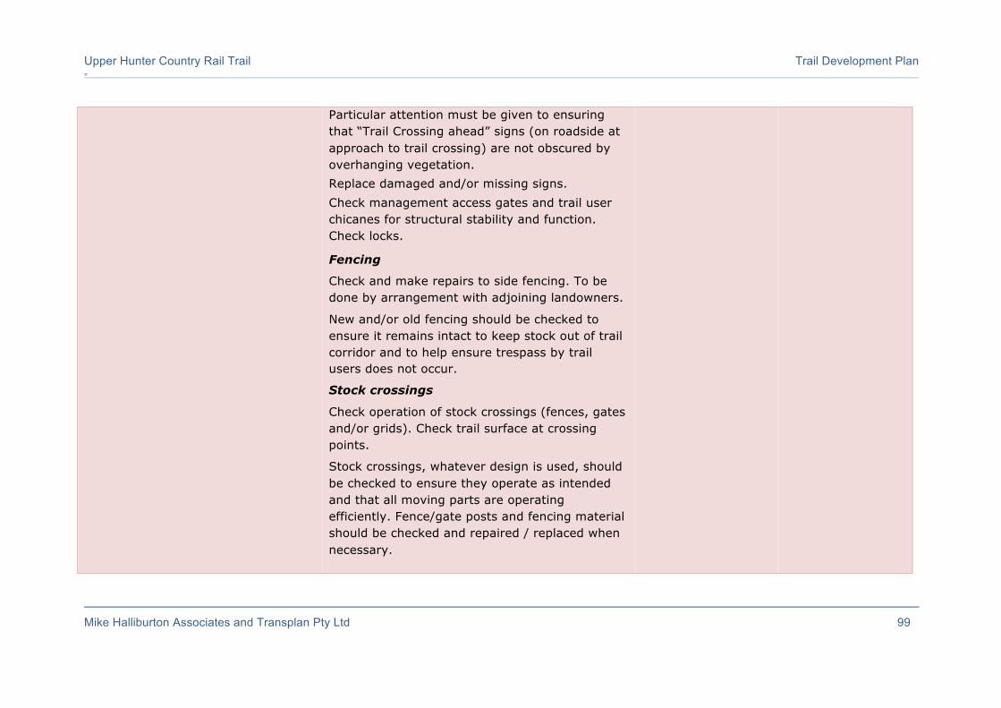
Upper Hunter Country Rail Trail Trail Development Plan =
Mike Halliburton Associates and Transplan Pty Ltd 99
Particular attention must be given to ensuring that “Trail Crossing ahead” signs (on roadside at approach to trail crossing) are not obscured by overhanging vegetation. Replace damaged and/or missing signs. Check management access gates and trail user chicanes for structural stability and function. Check locks.
Fencing
Check and make repairs to side fencing. To be done by arrangement with adjoining landowners.
New and/or old fencing should be checked to ensure it remains intact to keep stock out of trail corridor and to help ensure trespass by trail users does not occur.
Stock crossings
Check operation of stock crossings (fences, gates and/or grids). Check trail surface at crossing points.
Stock crossings, whatever design is used, should be checked to ensure they operate as intended and that all moving parts are operating efficiently. Fence/gate posts and fencing material should be checked and repaired / replaced when necessary.

Upper Hunter Country Rail Trail Trail Development Plan =
Mike Halliburton Associates and Transplan Pty Ltd 100
Trail surface at crossing points may need repairs where the passage of machinery and/or stock has caused damage.
Property boundary gates and cross fencing
Check gates and/or fencing at property boundaries. Make repairs where necessary.
Regular inspection is required where fences and gates have been installed across the corridor at property boundaries to ensure stock that somehow has entered the corridor are unable to move along the corridor.
Check signage and clean, replace or repair as required esp. road crossing signage and directional markers.
All signage should be checked for vandalism and cleaned if necessary. If damage is too great, replacement is essential.
An inventory of locations of all signs needs to be prepared to assist in regular maintenance.
Check, repair or replace all trail signage, including interpretive signage, trail distance and directional markers (logo/arrow plates), “No Trespassing” signs, bridge load signs, and Emergency Markers). Replace missing and/or damaged signs.
All locations Every third month - at each trail inspection
Slashing of trail environs Various locations Monthly in spring and summer, less frequently in autumn and winter (10 times/year)
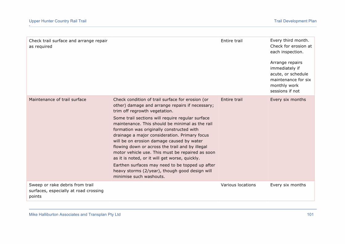
Upper Hunter Country Rail Trail Trail Development Plan =
Mike Halliburton Associates and Transplan Pty Ltd 101
Check trail surface and arrange repair as required
Entire trail Every third month. Check for erosion at each inspection.
Arrange repairs immediately if acute, or schedule maintenance for six monthly work sessions if not
Maintenance of trail surface Check condition of trail surface for erosion (or other) damage and arrange repairs if necessary; trim off regrowth vegetation.
Some trail sections will require regular surface maintenance. This should be minimal as the rail formation was originally constructed with drainage a major consideration. Primary focus will be on erosion damage caused by water flowing down or across the trail and by illegal motor vehicle use. This must be repaired as soon as it is noted, or it will get worse, quickly.
Earthen surfaces may need to be topped up after heavy storms (2/year), though good design will minimise such washouts.
Entire trail Every six months
Sweep or rake debris from trail surfaces, especially at road crossing points
Various locations Every six months

Upper Hunter Country Rail Trail Trail Development Plan =
Mike Halliburton Associates and Transplan Pty Ltd 102
Maintenance of culverts and other drainage measures
Check and clear drains and culverts. Drains need to be checked and cleared once or twice/year (absolute minimum) and after heavy rainfall events. Regular maintenance especially after heavy rainfall is essential. Most maintenance will involve clearing of material from silted up or blocked drains. Drain blockages should be cleared as urgent priority. Silt traps at culvert discharges or entry points should be cleared regularly. Cess drains in cuttings should be checked to ensure they function effectively.
Entire trail Every six months
Cut back regrowth, intruding and overhanging vegetation.
Check overhanging or intruding vegetation. Cut back where required. Clear fallen trees and branches.
Undergrowth vegetation grows quickly, and over time will continue to intrude into the trail 'corridor'. Such intruding vegetation needs to be cut back to provide clear and safe passage for trail users.
"Blow-downs" - trees or limbs that have fallen across the trail – need to be cleared as/when required. Sight lines must be kept clear either side of road crossings, to ensure that users can clearly see a safe distance either way at road crossings.
Entire trail Every six months, unless obviously requiring attention at regular inspections

Upper Hunter Country Rail Trail Trail Development Plan =
Mike Halliburton Associates and Transplan Pty Ltd 103
Check structural stability of interpretive signage, and interpretive shelters.
Check structural stability of seating, distance posts. Inspect and replace when needed.
Interpretive panels should be checked for vandalism and cleaned if necessary. If damage is too great, replacement is essential. An inventory of locations needs to be prepared to assist in regular maintenance.
Furniture alongside trails, if installed, needs to be checked regularly for damage to ensure safety and comfort of trail users.
Entire trail Every six months
Undertake Hazard Inspection and prepare Hazard Inspection Report
This should be done annually. Inclusion of a formal Hazard Inspection process, crucial in addressing risk, is necessary in the ongoing maintenance plan. Not only will this define maintenance required and/or management decisions to be addressed, it is vital in ensuring safe conditions and therefore in dealing with any liability claim which may arise in the future. Courts are strongly swayed by evidence of a clear and functional program, and a regular series of reports, with follow-up actions, will go a long way to mitigating responsibility for injuries. Further, clearly defined ‘User Responsibility’ statements in brochures, maps, policy documents, plans and public places will assist this process.
Entire trail Annually
Check structural integrity of bridges. Inspect and maintain bridges.
Visual inspection is appropriate though detailed inspection should follow storm and flood events.
Annually
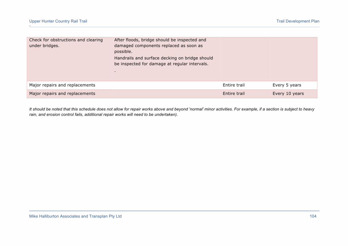
Upper Hunter Country Rail Trail Trail Development Plan =
Mike Halliburton Associates and Transplan Pty Ltd 104
Check for obstructions and clearing under bridges.
After floods, bridge should be inspected and damaged components replaced as soon as possible. Handrails and surface decking on bridge should be inspected for damage at regular intervals. .
Major repairs and replacements Entire trail Every 5 years
Major repairs and replacements Entire trail Every 10 years
It should be noted that this schedule does not allow for repair works above and beyond 'normal' minor activities. For example, if a section is subject to heavy rain, and erosion control fails, additional repair works will need to be undertaken).

Upper Hunter Country Rail Trail Trail Development Plan
Mike Halliburton Associates and Transplan Pty Ltd 105
7.5.5 Maintenance Costs
Resourcing a maintenance program is crucial, and funds will be required on an ongoing basis to enable this essential maintenance. It would be short sighted to go ahead and build the trail and then baulk at the demands of managing and maintaining it.
Estimating the cost of maintaining a trail is difficult due to the unpredictability of events such as floods, fires, high winds and stormwater runoff, as well as the tenure and management arrangements for the trail. Deliberate and willful damage and vandalism can also contribute significantly to the need for ongoing maintenance and replacement of infrastructure. Volunteers can be organised (through a coordinated program) to carry out much of the work at no cost to the trail manager (the roles and management of volunteers is discussed at length in the 2015 Upper Hunter Rail Trail Feasibility Study).
Evidence of actual trail maintenance costs for individual items along a rail trail, or any trail for that matter, are scarce. The Rail to Trails Conservancy in the USA (Rail-Trail Maintenance and Operation – Ensuring the Future of Your Trails – A Survey of 100 Rail-Trails, July 2005) provides two general answers for why it is difficult to estimate maintenance costs. First, the trail may be part of a larger budget for a single park or even an entire parks and recreation department. Specific costs for the trail aren’t separated out. Second, small trail groups, though run by competent and extremely dedicated volunteers, tend to be ‘seat-of-the-pants’ operations. Maintenance is done “as needed,” funds are raised “as needed,” and the people are volunteering because they love the trail, not because they love doing administrative tasks like budgeting.
Maintenance responsibility does appear to significantly affect cost. Approximately 60% of the surveyed trails reporting costs were maintained primarily by a government agency, implying paid staff and/or contractors. The other 40% of trails were primarily maintained by a non-profit or volunteer organisation. Annual costs for government-run trails were just over $2,000 per mile ($1,250/km). This is not much more than the overall average of $1,500/mile ($940/km), but it nearly triples the average for volunteer-run trails of just under $700 per mile ($440/km).
In Victoria, the Murrindindi Shire Council manages and maintains approximately 85% of the (134km) Great Victorian Rail Trail. It spends around $2,000/km on maintenance activities each year. Anecdotal information indicates that initial construction issues necessitate an increased level of maintenance of the trail surface (and drainage through cuttings). A higher level of (initial) construction quality (i.e. better trail surfacing) would mean less ongoing maintenance.
Volunteers could undertake much of the ongoing maintenance of the trail if a volunteer maintenance program is arranged. It should be ensured that whoever is charged with ongoing responsibility for managing the trails has genuine and specific trail knowledge. It is not sufficient to be a skilled gardener, conservationist or environmental scientist. If training is required to bring staff knowledge levels up to a high standard, this should be seen as a priority to be undertaken early in the construction process. Trail skills are better learned over a longer time, with hands-on practice, than in short briefing sessions.
The biggest maintenance costs involved are obviously maintenance of the items that initially cost the most to install: the trail surface itself (due to erosion from stormwater

Upper Hunter Country Rail Trail Trail Development Plan =
Mike Halliburton Associates and Transplan Pty Ltd 106
runoff and usage – especially misuse by unauthorised users such as trail bike riders) and maintenance of bridges.
It is difficult estimating the costs involved in maintaining a trail until every last bridge and other infrastructure items have been installed.
Table 7 makes an attempt at estimating an amount that may be required on an annual basis for maintaining the proposed Upper Hunter Country Rail Trail.
The use of volunteers to undertake many of the routine repairs and cleaning tasks can substantially reduce the costs.
Table 7: Estimate of Maintenance Costs (Upper Hunter Country Rail Trail – 40.3km)
Task Frequency/note Possible costs
Inspect and check trailhead facilities and infrastructure:
- parking areas (check surfaces) - bollards and wire ropes - bicycle parking - interpretive panel - seating/shelter/picnic tables - trailhead signage (on road) - trailhead (map) panel - trail directional marker posts - distance signage - Code of Conduct signage
5 trailheads at average repairs of $500 per site
$2,500
Trail surface - allowance for incidental repairs to, and upgrading of, gravel trail surface.
Allowance of 2% of replacement cost (i.e. 2% of $2,392,500).
$47,850
Check side vegetation growth and overhead vegetation and cut back where required. Clearing of fallen trees and branches.
Allowance of 3 person days per 10km section per year (@ $500/day).
$6,000
Inspection and routine maintenance of bridges (all timber components, decking, handrails, etc.). Check for obstructions and clearing under bridges.
Allowance of $8,000 per year for large timber bridges (2), $400 per year for short timber bridges (2), $1,500 per year for new installations (27)
$57,300
Check and clear culverts. Allowance of 10 hours for checking and cleaning
$1,000
Check road crossings. Replace damaged and/or missing signs and undertake other tasks:
- Give Way signs
4 crossings at average repairs of $300 per crossing
$1,200

Upper Hunter Country Rail Trail Trail Development Plan =
Mike Halliburton Associates and Transplan Pty Ltd 107
- Road Ahead signs - Trail Crossing warning signs - Road name signs - Regulatory signs - Check sight distances and
clear vegetation if necessary
Inspection of and allowance for replacement of trail directional marker logo/arrow plates and trail kilometre posts.
5 replacements per 10km section per year
$600
Check Emergency Marker signage and replace missing and/or damaged signs.
Allowance for replacement of one sign per year / 10km.
$600
Allowance for repairs to trailside furniture and occasional replacements (when required).
Inspection and minor repairs every 6 months. 1 replacement per year.
$1,000
Check miscellaneous signs along trail (e.g. Road Ahead, Give Way, trail name, distance signs, “No Trespassing”, bridge load signs, etc).
5 replacements per 10km section per year.
$600
Check management access gates and fences at road crossings. Make repairs where necessary.
Allowance of $2,000 per year for repairs.
$2,000
Check toilet. Allowance for cleaning $500
Check operation of stock crossings (fences, gates and grids).
Allowance for minor repairs $500
Check interpretation along trail for damage and structural stability.
Allowance for replacement of 1 panel per year.
$3,000
Inspection of rail trail (3 times/year). Allowance for 3 inspection trips per year
$4,500
Preparation of annual Hazard Inspection Report.
1 person days @ $1000/day. $1,000
$130,150 excl GST (per annum)
This equates to a rate of approximately $3,253 per kilometre per annum.
Note 1: Use of volunteers would substantially reduce maintenance costs.
Note 2: Reporting of routine maintenance requirements by trail users will obviate need for many scheduled inspections.
Note 3: Appointment of a Trail Manager, with responsibility for regular inspections of entire trail, will substantially reduce need for unscheduled and expensive maintenance.
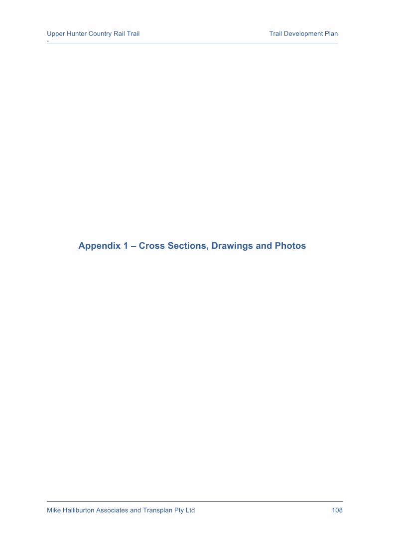
Upper Hunter Country Rail Trail Trail Development Plan =
Mike Halliburton Associates and Transplan Pty Ltd 108
Appendix 1 – Cross Sections, Drawings and Photos
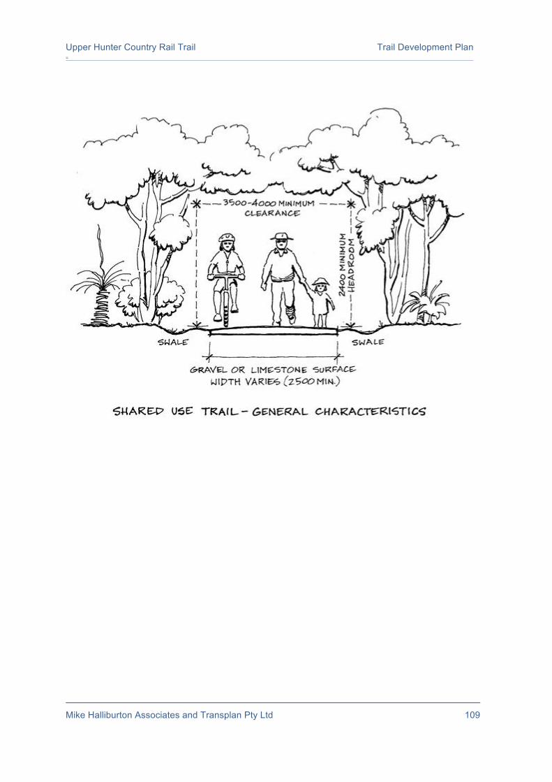
Upper Hunter Country Rail Trail Trail Development Plan =
Mike Halliburton Associates and Transplan Pty Ltd 109

Upper Hunter Country Rail Trail Trail Development Plan =
Mike Halliburton Associates and Transplan Pty Ltd 110

Upper Hunter Country Rail Trail Trail Development Plan =
Mike Halliburton Associates and Transplan Pty Ltd 111
Above: Stock Crossing Type A: crossing open 24/7 for stock and machinery. Below: Stock Crossing Type B: Trail open 24/7. Gates in side fences.
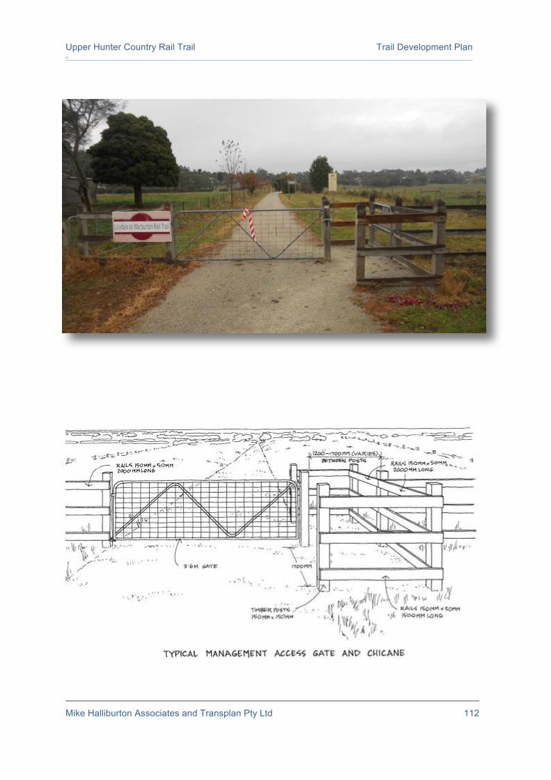
Upper Hunter Country Rail Trail Trail Development Plan =
Mike Halliburton Associates and Transplan Pty Ltd 112

Upper Hunter Country Rail Trail Trail Development Plan =
Mike Halliburton Associates and Transplan Pty Ltd 113

Upper Hunter Country Rail Trail Trail Development Plan =
Mike Halliburton Associates and Transplan Pty Ltd 114
Upper Hunter Country Rail Trail Trail Development Plan =
Mike Halliburton Associates and Transplan Pty Ltd 115

Upper Hunter Country Rail Trail Trail Development Plan =
Mike Halliburton Associates and Transplan Pty Ltd 116
Upper Hunter Country Rail Trail Trail Development Plan =
Mike Halliburton Associates and Transplan Pty Ltd 117
Appendix 2 – Trailhead Drawings
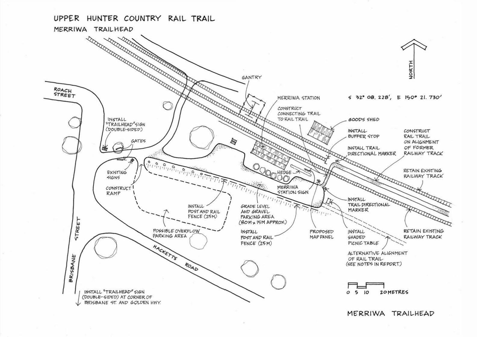


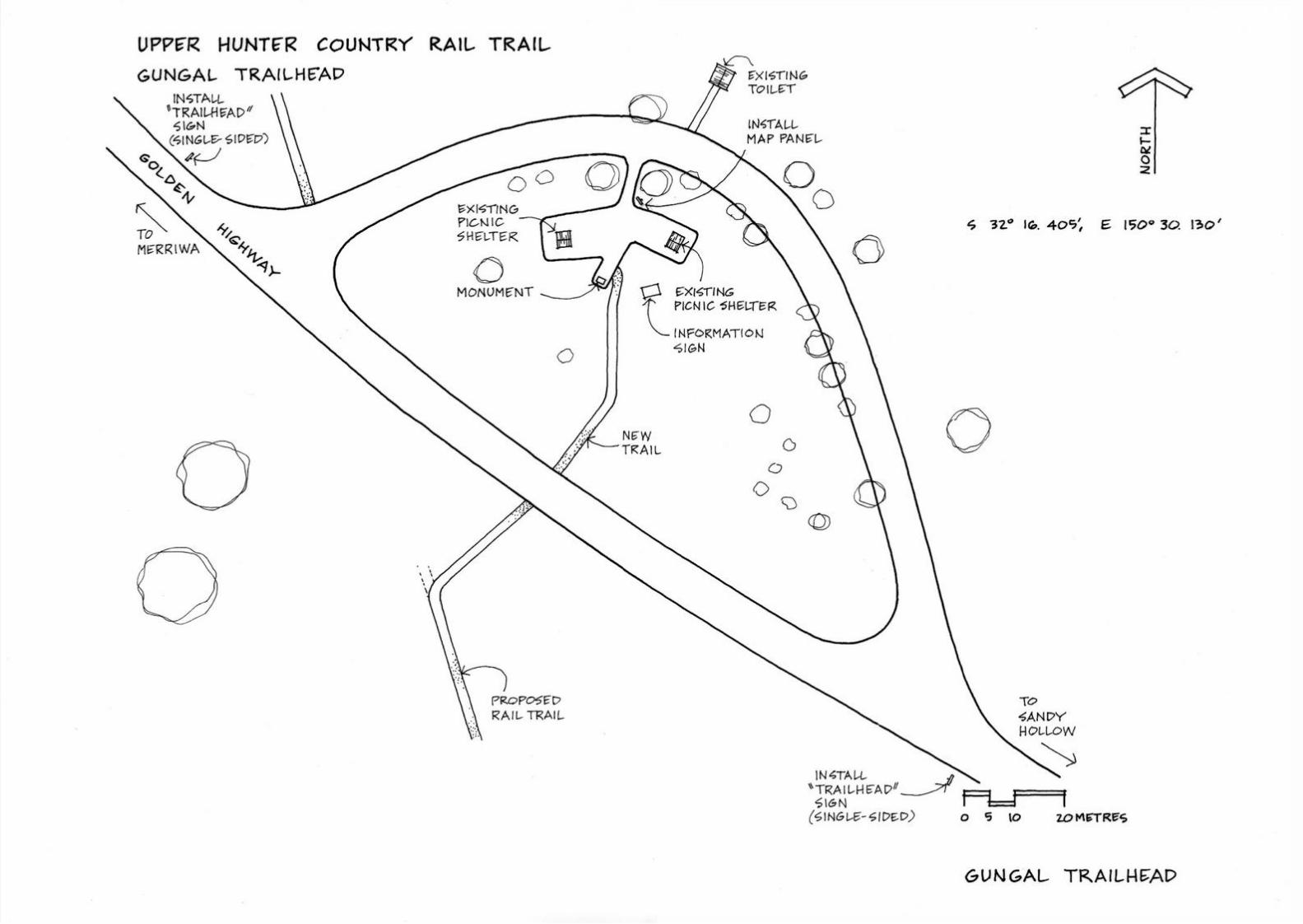


Upper Hunter Country Rail Trail Trail Development Plan =
Mike Halliburton Associates and Transplan Pty Ltd 122
Appendix 3 – Road Crossing Drawings


Upper Hunter Country Rail Trail Trail Development Plan =
Mike Halliburton Associates and Transplan Pty Ltd 127
Appendix 4 – Halls Creek Bridge Report

P RO P O S E D R A I L T R A I L , M E R R I WA
T O S A N DY H O L L OWHALLS CREEK BRIDGE, SANDY HOLLOW
DESIGN STUDY FORMIKE HALLIBURTON ASSOCIATES
RECREATION TRAIL PLANNERSBill Jordan & Associates Pty LtdABN 83 003 320 652
Chartered Structural Engineer specialising in conservation of historical structuresPO Box 141 NEWCASTLE NSW 2300 Telephone: (02)4929 4841 Fax: (02)4929 7933 E-mail: [email protected] Web: www.bjaeng.com.auLiability limited by a scheme approved under Professional Standards Legislation
BJ&A Job No: Z005
Document Revision History
Revision Prepared By Description DateA Bill Jordan Concept design report for
review22/9/2016
B Bill Jordan Minor amendments 22/9/2016
Authorisation
Role Name Signature Date
Copyright - Bill Jordan & Associates Pty Ltd 2015 - All rights reserved. No part of this document may be reprinted, reproduced, stored in a retrieval system, or transmitted in any form or by any means, electronic or mechanical, photocopying, recording or otherwise without the prior permission in writing of the Consulting Engineer.
ii

1
September 2016 Halls Creek BridgeConcept report & design
PROPOSED RAIL TRAIL, MERRIWA TO SANDY HOLLOW
H A L L S C R E E K B R I D G E , S A N DY H O L L OW
1 SUMMARY OF FINDINGS
The remains of the former railway bridge over Halls Creek, Sandy Hollow, are suitable for reuse as part of a proposed bicycle trail along the old railway alignment.
Subject to certification of the existing steel and concrete structural elements over the watercourse, the provision of approach spans to replace the demolished timber spans, with the addition of a suitable deck and barriers to suit the usage, can be readily accomplished.
2 INTRODUCTION
The railway line from Sandy Hollow to Merriwa is recorded as having opened in October 1917 and closed in February 19881. The line is recorded as being 38.3 km long.
It is understood that Muswellbrook and Upper Hunter Shire Councils are investigating the feasibility of converting the railway alignment to a “Rail Trail” linking to the two towns for recreational purposes.
The original railway bridge had the existing steel girder main span which was approached on both sides by two timber beam spans.
3 PROJECT DESCRIPTION
3.1 The Brief
Mike Halliburton Associates, Recreation Trail Planners, asked Bill Jordan & Associates to look into the feasibility of reusing the Halls Creek bridge remains as part of a new bridge over the creek.
3.2 Work undertaken
The site was visited on 15 September 2016 and the existing structure was photographed and measurements of the likely approach span length taken using a laser distance meter. No access was available to the concrete piers or steel girder but, from a distance and from the photographs taken, no serious defects were seen.
Using the dimensions measured on site and estimated from photographs, a concept design, with alternative options, was prepared for the construction of new approach spans.
4 CONCEPT DESIGN
4.1 Standards
No Australian Standards exist which are specific to bicycle ways on old railway infrastructure. The two Standards which are considered applicable to the bridge are:
• AS 2156.2, Walking tracks, Part 2: Infrastructure Design, and
• AS 5100 (various parts), Bridge design.
1 Quinlan H. & Newland J.R., Australian Railway Routes 1854 - 2000, Australian Railway Historical Society, NSW Division.

2 of 5
September 2016Halls Creek BridgeConcept report & design
Some of the requirements of both these standards may not suit all the needs of the project concerned and reference to overseas standards or industry guidelines may be necessary to achieve a practicable result.
4.2 Use of existing span
There appears to be no reason why the existing steel span cannot be used as part of a new bridge. The design capacity of the span would have been well in excess of what is required for bicycle path load, or even highway loading. The excess load capacity of the original design would allow a level of deterioration without affecting the new use. A thorough structural check will be necessary before final design is undertaken with particular attention to joints at the bottom of the girder where corrosion is most likely on the inside.
It is likely that the paint remaining on the girder is lead based and this will need treatment in accordance with the appropriate environmental controls.
No significant deterioration of the concrete piers could be detected from a distance. They could be adapted to carry the approach span ends if something prevents landing the new spans on the girder.
It is highly unlikely that the creek cross section could be reduced to shorten the approach spans and a hydrological and hydraulic study will be required to ensure that sufficient waterway is available for the new structure. The timber beams appear to have been wrenched from their supports on the main girder and the possibility that this was by flooding cannot be discounted: this may require longer approach spans than has been allowed.
4.3 Design parameters
4.3.1 SOURCE
AS 2156.2 specifically excludes “structures intended to carry livestock (e.g. horses) or vehicles (including bicycles and light maintenance vehicles)”. However, the recreational usage of a rail trail is similar to the intended usage of a walking track and in the absence of a specific standard, AS 2156 could be considered in part.
AS 5100 has specific provisions for bicycle paths in clause 9.13 (width) and clause 12.1 (barriers) of AS 5100.1. Clause 7.1 of AS 5100.2 gives required design loads.
4.3.2 PARAMETERS
The following design parameters are taken from AS 5100.1 and AS 5100.2:
• Clear width of structure 3.0 m
• Minimum barrier rail height 1.3 m
• Design load 5 kPa
4.4 Design form and alternatives
The results of the concept design are shown on the drawing in Appendix A, Z005-Sk.1A
The original bridge used timber beam approach spans and the connections for these timber beams remain on the ends of the steel girder main span. There appears to be no reason why the brackets on the ends of the main girder cannot be reused for new approach spans, either steel or timber.
Two concept designs have been prepared using steel trusses. The parallel chord alternative would be simpler to fabricate but would be heavier. The alternative with a convex bottom chord would be slightly lighter and may be considered more aesthetically pleasing. Both alternatives have the potential of being fabricated and treated off site and being lifted into place as a whole.
The deck structure, including the barriers, could be fabricated and fitted separately or included in the single crane lift if a suitable crane was available. The erection procedure should form part of the final design.

3
September 2016 Halls Creek BridgeConcept report & design
5 ESTIMATE OF COST
5.1 Basis
A number of significant factors still have to be considered before a more realistic estimate can be formulated. What follows should be taken as “order of magnitude” only. A more accurate estimate for budgetary purposes would be available from a Quantity Surveyor or contractor experienced in this type of work.
5.2 Preliminary budget estimate
Item Quantity Rate TotalApproach spans incl. deck and barriers 60 m² $1200 $72,000New abutments, concrete 6 m³ $1000 $6,000Deck, main span 45 m² $300 $13,500Treatment/painting main span allow $50,000Fees @ 10% allow $14,000Contingency etc. @ 15% allow $20,000TOTAL, allow $180,000
6 CONCLUSIONS
The remains of the existing railway bridge over Halls Creek, Sandy Hollow, are suitable for conversion into a bridge on the proposed Merriwa to Sandy Hollow Rail Trail and a concept design has been developed.
for and on behalf of Bill Jordan & Associates Pty Ltd
J.W. Jordan FIEAust CPEng

AppendicesSeptember 2016 Halls Creek BridgeConcept report & design
APPENDIX A
Drawing Z005 - Sk.1A of concept design

Upper Hunter Country Rail Trail Trail Development Plan =
Mike Halliburton Associates and Transplan Pty Ltd 135
Appendix 5 – Example Rail Trail Maintenance Checklist
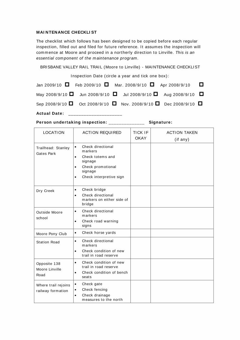
MAINTENANCE CHECKLIST
The checklist which follows has been designed to be copied before each regular inspection, filled out and filed for future reference. It assumes the inspection will commence at Moore and proceed in a northerly direction to Linville. This is an essential component of the maintenance program.
BRISBANE VALLEY RAIL TRAIL (Moore to Linville) - MAINTENANCE CHECKLIST
Inspection Date (circle a year and tick one box):
Jan 2009/10 Feb 2009/10 Mar. 2008/9/10 Apr 2008/9/10
May 2008/9/10 Jun 2008/9/10 Jul 2008/9/10 Aug 2008/9/10
Sep 2008/9/10 Oct 2008/9/10 Nov. 2008/9/10 Dec 2008/9/10
Actual Date: _____________________
Person undertaking inspection: ______________ Signature:
LOCATION ACTION REQUIRED TICK IF OKAY
ACTION TAKEN
(if any)
Trailhead: Stanley
Gates Park
• Check directional markers
• Check totems and signage
• Check promotional signage
• Check interpretive sign
Dry Creek • Check bridge • Check directional
markers on either side of bridge
Outside Moore
school
• Check directional markers
• Check road warning signs
Moore Pony Club • Check horse yards
Station Road • Check directional markers
• Check condition of new trail in road reserve
Opposite 138
Moore Linville
Road
• Check condition of new trail in road reserve
• Check condition of bench seats
Where trail rejoins
railway formation
• Check gate • Check fencing • Check drainage
measures to the north

Side trail to
cemetery
• Check gate • Check directional
markers • Check attraction signage • Check road warning
signs • Check bench seat and
hitching rail
Creek crossing –
Boundary Creek
• Check warning signage • Check condition of
approach and crossing
Interpretive panel
- “One for the
road”
• Check interpretive sign • Check bench seat and
hitching rail
Creek crossing –
Greenhide Creek
• Check warning signage • Check condition of
approach and crossing • Check gate
Moore-Linville
Road crossing
(south)
• Check road warning signs
• Check gates both sides • Check bench seat
Moore-Linville
Road crossing
(north)
• Check road warning signs
• Check gates both sides (and gate 150 m south)
Trailhead: Linville
Station
• Check directional markers
• Check totems and signage
• Check promotional signage
• Check interpretive sign • Check trailhead furniture
• Check horse yards
Any additional
work required?

Hazard Inspection Whole trail - annually
Annual budget
allocation
Discuss with staff

Upper Hunter Country Rail Trail Trail Development Plan =
Mike Halliburton Associates and Transplan Pty Ltd 139
Appendix 6 – Rail Trail Plans 1 - 4

SCONE RD
GOLDEN HWY
GOLDEN HWY
GOLDEN HWY
GOLDEN HWY
GOLDEN HWY
DEP
OT
RD
PR
ICE
S L
AN
E
MACARTNEY ST
BR
ISB
A NE
ST
BR
ISB A
NE
ST
HACKETTS RD
SCONE RD
SCONE RD
SCONE RD
HALL RD
FLAGGS RD
HALL RD
FLAGGS RD
HALL RD
GOLDEN HWY
GOLDEN HWY
GOLDEN HWY
PR
ICE
S L
AN
E
LAW
LER
S LA
NE
LAW
LER
S LA
NEQ
UIG
LEY
ST
BR
IND
L EY
RD
COLLINS ST
COLLINS ST
COLLINS ST
WILLIAM ST
COLLINS ST
MAH
E R S
T
SC
ULL
Y C
L
KING GEORGE V AVE
RIF
L E R
A NG
E R
D
BR
I SB A
NE
ST
KING GEORGE V AVE
MACKENZIE ST
BETTINGTON ST
MA
RQ
UE
T S
T
MAR
QU
E T S
T
MACKENZIE ST
MAR
QU
E T S
T
JOHN ST
MAR
QU
E T S
T
MAR
QU
E T S
T
MAR
QU
E T S
T
BLAXLAND ST
BLAXLAND ST
BETTINGTON ST
MAR
QU
ET
ST
VE
NN
AC
HE
R S
T
MACARTNEY ST
VE
NN
AC
HE
R S
T
LANGLEY ST
BOW
ST
LANGLEY ST
BOW
ST
VEN
NA
CH
ER S
T
VEN
NA
CH
ER S
T
VEN
NA
CH
ER S
T
DU
T TO
N S
T
BO
W S
T
BO
W S
T
BO
W S
T
BLAXLAND ST
BO
W S
T
BO
W S
T
GO
OC
H S
T
GO
OC
H S
T
GO
OC
H S
T
GLEBE ST
HAYES ST
VEN
NA
CH
ER S
T
VEN
NA
CH
ER S
T
COLLINS ST
GO
OC
H S
T
DU
T TO
N S
T
CULLINGRAL ST
BETTINGTON ST
BO
W S
T
DU
T TO
N S
T
BO
W S
T
MACKENZIE ST
BETTINGTON ST
MACKENZIE ST
TELFER ST
LDEN HWY
VEN
NA
CH
ER S
T
VEN
NA
CH
ER S
T
HALL RD
DEPOT
RD
FLAG
GS
RD
PR
ICE
S L
AN
E
DEP
OT
RD
FLAGGS RD
Upper Hunter CountryRail Trail Development PlanDecember 2016
Plan 1Merriwa to Wappinguy
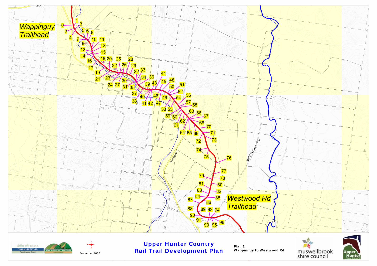
GO
LDEN
HW
Y
WESTWOOD RD
GOLDEN HWY
GIANTS CREEK RD
WES
TWO
OD
RD
GOLDEN HWY
GOLDE
GO
LDEN
HW
Y
GOLDEN HWY
GO
LDEN
HW
Y
GOLDEN HWY
F
FLAGGS RD
FLAGGS RD
Upper Hunter CountryRail Trail Development PlanDecember 2016
Plan 2Wappinguy to Westwood Rd

MYERS GAP RD
GIANTS CREEK RD
GO
LDE
N H
WY
LILY ST
GIA
NTS
CR
EEK R
D
MAITLAND ST
GIANT
S CR
EEK
RDG
OLD
EN H
WY
GO
LDEN HWY
GO
LDEN HWY
WESTWOOD RD
GIANTS CREEK RD
GIA
NTS
CR
EEK
RD
GI A
NTS
CR
EE K
RD
WO
RO
ND
I CR
EE
K R
D
GIAN
TS C
RE
E K R
D
GREG STAIRS RD
GIAN
TS CR
EEK RD
GREG STAIRS RD
GR
EG S
TAIR
S R
DGOLDEN HWY
MER
RIWA ST
PERRY ST
LILY ST
OUDE ST
GOLDEN HWY
MAITLAN
D ST
STELLA STM
AITLAND ST
GOLDEN HWY
GOLDEN HWY
IRIS ST
FLAGGS RD
GOLDEN HWY
FLAGGS RD
GO
LDEN
HWY
FLAGGS RD
F LA
GG
S R
D
FLAGGS RD
FLAGGS RD
FLAGGS RD
Upper Hunter CountryRail Trail Development PlanDecember 2016
Plan 3Westwood Rd to Gungal

BYLONG VALLEY WAY
BYLONG V
ALLEY W
AY
HO
NEY
LA
NE
BYLONG VALLEY WAY
GIA
NTS
CR
EEK
RD
GIANTS CREEK RD
MYERS GAP RD
GIANTS CREEK RD
GIA
NTS
CR
EEK
RD
GO
L DE
N H
WY
LILY ST
IAN
TS C
REE
K RD
WYB
ONG
BYLONG VALLEY WAY
GOLDEN HWY
GOLDEN HWY
GOULBURN DR
GOULBURN DR
GOLDEN HWY
GOLDEN HWY
GO
UL B
UR
N D
R
PEBERDYS RD
PEBERDYS RD
BYLO
NG V
ALLE
Y W
AY
GOLDEN HW
Y
GOLDEN HWY
WO
RO
ND
I CR
EE
K R
D
GREG STAIRS RD
WORONDI CREEK RD
WO
RO
ND
I CR
EEK R
D
WO
RO
ND
I CR
EE
K R
D
WO
RO
ND
I CR
EEK
RD
WORONDI CREEK RD
WO
RO
ND
I CR
EEK R
D
MER
RIWA ST
PERRY ST
LILY ST
OUDE ST
GOLDEN HWY
MAITLAN
D ST
GOLDEN HWY
FLAGGS RD
Upper Hunter CountryRail Trail Development PlanDecember 2016
Plan 4Gungal to Sandy Hollow