Embed Size (px)
Citation preview

Page 1 of 255
Project No. NCHRP 20-7 Task 187 COPY NO.
UPDATING THE AASHTO GUIDE FOR THE DEVELOPMENT OF
BICYCLE FACILITIES
FINAL REPORT
Prepared for National Cooperative Highway Research Program
Transportation Research Board National Research Council
TRANSPORTATION RESEARCH BOARD NAS-NRC
PRIVILEGED DOCUMENT
This report, not released for publication, is furnished only for review to members of or participants in the work of the National /cooperative Highway Research Program (NCHRP). It is to be regarded as fully
privileged, and dissemination of the information included herein must be approved by the NCHRP.
Theodore A. Petritsch, P.E. Sprinkle Consulting, Inc. Sprinkle Project 8097-04
March 2005

Page 2 of 255
ACKNOWLEDGMENT OF SPONSORSHIP
This work was sponsored by the American Association of State Highway and
Transportation Officials, in cooperation with the Federal Highway Administration, and was
conducted in the National Cooperative Highway Research Program, which is administered by the
Transportation Research Board of the National Research Council.
DISCLAIMER
This is an uncorrected draft as submitted by the research agency. The opinions and
conclusions expressed or implied in the report are those of the research agency. They are not
necessarily those of the Transportation Research Board, the National Research Council, the
Federal Highway Administration, the American Association of State Highway and
Transportation Officials, or the individual states participating in the National Cooperative
Highway Research Program.

Page 3 of 255
TABLE OF CONTENTS
ACKNOWLEDGMENTS ...............................................................................................................9 ABSTRACT.....................................................................................................................................9 CHAPTER 1: INTRODUCTION..................................................................................................11 CHAPTER 2: RESEARCH APPROACH....................................................................................13
Task 1. Survey of Users ........................................................................................................... 13 Task 2. Literature Review........................................................................................................ 17 Task 3. Identification of Gaps and Needs................................................................................ 17
CHAPTER 3: LITERATURE SEARCH......................................................................................18
Introduction............................................................................................................................... 18 State and Local Design Guidance ............................................................................................. 20
Guidelines for Bicycle and Pedestrian Facilities in Texas ................................................... 20 City of Davis Comprehensive Bicycle Plan .......................................................................... 23 Bicycle Parking Facilities Guidelines (City of Portland)..................................................... 25 Highway Design Manual (California) .................................................................................. 27 Florida Bicycle Facilities Planning and Design Handbook................................................. 29 Idaho Bicycle and Pedestrian Transportation Plan ............................................................. 33 Local Bicycle Facility Design Guidance for the Metropolitan Kansas City Region ............ 35 Vermont Pedestrian and Bicycle Facility Planning and Design Manual............................. 37 Design Manual, Chapter 1020, “Bicycle Facilities” (Washington State Department of Transportation) ..................................................................................................................... 40 Wisconsin Bicycle Facility Design Handbook ...................................................................... 42
National Guidance .................................................................................................................... 45 An Informational Guide for Roadway Lighting .................................................................... 45 Bicycle Parking Guidelines................................................................................................... 46 Collection of Cycle Concepts (Denmark) ............................................................................. 47 Recommended Lighting for Walkways and Class I Bikeways .............................................. 49 Bike Lane Design Guide ....................................................................................................... 50 Designing Sidewalks and Trails for Access – Part II of II: Best Practices Design Guide .. 52 Roundabouts: An Informational Guide................................................................................ 54 Highway Capacity Manual ................................................................................................... 57 Trail Intersection Design Handbook .................................................................................... 59 Selecting Roadway Design Treatments to Accommodate Bicycles....................................... 61 Safety Effects of Marked vs. Unmarked Crosswalks at Uncontrolled Locations ................. 63
Synthesis of Practice ................................................................................................................. 65 Bicycle Facility Selection: A Comparison of Approaches ................................................... 65 Conflicts on Multiple-Use Trails: Synthesis of the Literature and State of the Practice .... 67 Innovative Bicycle Treatments: An Informational Report ................................................... 70
Research on Bicycle Facilities and Users ................................................................................. 71 Operational Analysis of Uninterrupted Bicycle Facilities.................................................... 71 San Francisco’s Shared Lane Pavement Markings: Improving Bicycle Safety .................. 74

Page 4 of 255
Sidewalk Bicycling Safety Issues .......................................................................................... 77 Development of the Bicycle Compatibility Index.................................................................. 79 Evaluation of Shared-Use Facilities for Bicycles and Motor Vehicle .................................. 82 Evaluation of a Combined Bicycle Lane/Right-Turn Lane in Eugene, Oregon ................... 84 Evaluation of Innovative Bike-Box Application in Eugene, Oregon .................................... 87 An Evaluation of Red Shoulders as a Bicycle and Pedestrian Facility ................................ 89 Evaluation of Blue Bike-Lane Treatment in Portland, Oregon ............................................ 91 An Evaluation of Bike Lanes Adjacent to Motor Vehicle Parking........................................ 93 Study of Bicycle Lanes Versus Wide Curb Lanes ................................................................. 95 Characteristics of Emerging Road and Trail Users and Their Safety.................................. 97 Real-Time Human Perceptions: Toward a Bicycle Level of Service ................................. 101 Intersection Level of Service for the Bicycle Through Movement ...................................... 104 Bicyclist Performance on a Multiuse Trail ......................................................................... 106 Evaluation of the Shared-Use Arrow .................................................................................. 108 Evaluation of Bicycle and Pedestrian Facilities: User Satisfaction and Perceptions on Three Shared Use Trails in Texas....................................................................................... 110 Bicycle and Pedestrian Detection: Final Report ............................................................... 112
Additional References Identified by Survey Respondents ..................................................... 114 CHAPTER 4: SURVEY RESULTS...........................................................................................118
How often do you use the AASHTO Guide?.......................................................................... 120 For what do you use the Guide? ............................................................................................. 121 Have you ever attended the National Highway Institute (NHI) Bicycle Facilities Design course? .................................................................................................................................... 122 What is your occupation?........................................................................................................ 123 For what agency/company do you work? or Which best describes your work setting?....... 125 What is your position title? ..................................................................................................... 127 Of which organizations are you a member? ........................................................................... 133 OPERATING SPACE REQUIRED FOR A BICYCLE ........................................................ 134 THE BICYCLE USER ........................................................................................................... 136 SELECTION OF A BICYCLE FACILITY OR CHOOSING THE APPROPRIATE FACILITY TYPE ................................................................................................................... 137 TYPES OF BICYCLE FACILITIES...................................................................................... 139 INVENTORY OF EXISTING CONDITIONS ...................................................................... 141 PLANS FOR IMPROVEMENTS........................................................................................... 143 SELECTION OF A BICYCLE FACILITY ........................................................................... 145
EDUCATION PROGRAMS FOR BICYCLISTS AND MOTORISTS .....................................148 Please indicate any other topics related to Bicycle Facilities Planning that should be addressed in the next Bike Guide update................................................................................................. 150 SHARED ROADWAYS ........................................................................................................ 151 PAVED SHOULDERS........................................................................................................... 153 INCREASED LANE WIDTH ................................................................................................ 155 BIKE FACILITIES WITH ON-STREET PARKING............................................................ 157 PAVEMENT SURFACE QUALITY..................................................................................... 158 DRAINAGE INLET GRATES............................................................................................... 159 SIGNED SHARED ROADWAYS......................................................................................... 160

Page 5 of 255
DESIGNATING SIDEWALKS AS SIGNED BIKEWAYS ................................................. 162 SIGNING OF SHARED ROADWAYS................................................................................. 164 BIKE LANES ......................................................................................................................... 165 BIKE LANE WIDTHS........................................................................................................... 166 BIKE LANES AT INTERSECTIONS ................................................................................... 168 BIKE LANES AND TURNING LANES............................................................................... 169 BIKE LANE SYMBOL GUIDELINES ................................................................................. 171 Please indicate any other topics related to Bike Lane Design that should be addressed in the next Bike Guide update........................................................................................................... 173 SHARED USE PATHS .......................................................................................................... 174 SEPARATION BETWEEN SHARED USE PATHS AND ROADWAYS........................... 176 WIDTH AND CLEARANCE ON SHARED USE PATHS................................................... 178 DESIGN SPEED..................................................................................................................... 180 HORIZONTAL ALIGNMENT.............................................................................................. 181 GRADE................................................................................................................................... 183 SIGHT DISTANCE................................................................................................................ 185 PATH ROADWAY INTERSECTIONS ................................................................................ 186 OTHER INTERSECTION DESIGN ISSUES........................................................................ 188 SIGNING AND MARKING .................................................................................................. 190 PAVEMENT STRUCTURE .................................................................................................. 191 STRUCTURES....................................................................................................................... 193 DRAINAGE............................................................................................................................ 195 LIGHTING ............................................................................................................................. 197 RESTRICTION OF MOTOR VEHICLE TRAFFIC ............................................................. 199 UNDESIRABILITY OF SIDEWALKS AS SHARED USE PATHS.................................... 201 SHARED USE WITH MOTORBIKES, HORSES AND SNOWMOBILES ........................ 202 RAILROAD CROSSINGS..................................................................................................... 203 BICYCLES ON FREEWAYS................................................................................................ 204 BICYCLE FACILITIES THROUGH INTERCHANGE AREAS......................................... 205 BICYCLE FACILITIES AT MODERN ROUNDABOUTS ................................................. 206 TRAFFIC SIGNALS .............................................................................................................. 207 OBSTRUCTION MARKINGS .............................................................................................. 209 BICYCLE PARKING FACILITIES ...................................................................................... 210 ADDITIONAL BICYCLE AMENITIES............................................................................... 212 ACCESSIBILITY REQUIREMENTS ................................................................................... 214 OPERATIONS AND MAINTENANCE................................................................................ 216 For what purpose do you primarily use the AASHTO Bike Guide? ...................................... 218
CHAPTER 5: PROPOSED ARRANGEMENT OF THE BIKE GUIDE ..................................220 CHAPTER 6: PROPOSED OUTLINE FOR THE NEXT UPDATE TO THE AASHTO GUIDE FOR THE DEVELOPMENT OF BICYCLE FACILTIES ............................................................223 CHAPTER 7: AREAS IDENTIFIED FOR FUTURE RESEARCH...........................................251 APPENDIX A .............................................................................................................................A-1

Page 6 of 255
LIST OF TABLES TABLE 1 Current and Previous Editions of National Manuals. ........................................... 19 TABLE 2 Lengths for User Types in the Vermont Manual and in the FHWA Study. ......... 39 TABLE 3 Recommended Grades in the AASHTO Bike Guide and Designing Sidewalks and Trails for Access. .......................................................................................................................... 53 TABLE 4 LOS Thresholds for 8-ft {2.4-m} and 10-ft {3.0-m} Paths. ................................. 72 TABLE 5 Design Criteria and Potential Design Users.......................................................... 99 TABLE 6 Calculated Segment LOS Values for Different Baseline Inputs......................... 102 TABLE 7 Detectors and Technologies Tested. ................................................................... 112
LIST OF FIGURES Figure 1. Design considerations for separated, multi-use pathways............................................ 34 Figure 2. Possible provisions for bicycles at roundabouts........................................................... 55 Figure 3. “Bike-in-house” marking.............................................................................................. 74 Figure 4. Bike-and-chevron marking........................................................................................... 74 Figure 5. Bicycle Compatibility Index model, variable definitions, and adjustment factors. ..... 80 Figure 6. Shared-use arrow in Gainesville, FL. ......................................................................... 108 Figure 7. How often do you use the AASHTO Guide? ............................................................. 120 Figure 8. For what do you use the Guide? ................................................................................. 121 Figure 9. What is your occupation? ........................................................................................... 123 Figure 10. Which best describes your work setting? ................................................................. 125 Figure 11. Of which organizations are you a member? ............................................................. 133 Figure 12. Operating Space Required for a Bicycle – How well does the Bike Guide address this subject area?................................................................................................................................ 134 Figure 13. The Bicycle User – How well does the Bike Guide address this subject area? ....... 136 Figure 14. Selection of a Bicycle Facility or Choosing the Appropriate Facility Type – How well does the Bike Guide address this subject area? .......................................................................... 137 Figure 15. Types of Bicycle Facilities – How well does the Bike Guide address this subject area? ............................................................................................................................................ 139 Figure 16. Inventory of Existing Conditions – How well does the Bike Guide address this subject area?................................................................................................................................ 141 Figure 17. Plans for Improvements – How well does the Bike Guide address this subject area?..................................................................................................................................................... 143 Figure 18. Selection of a Bicycle Facility – How well does the Bike Guide address this subject area? ............................................................................................................................................ 145 Figure 19. Education Programs for Bicyclists and Motorists – How well does the Bike Guide address this subject area? ............................................................................................................ 148 Figure 20. Shared Roadways – How well does the Bike Guide address this subject area?....... 151 Figure 21. Paved Shoulders – How well does the Bike Guide address this subject area?......... 153 Figure 22. Increased Lane Width – How well does the Bike Guide address this subject area? 155 Figure 23. Bike Facilities with On-street Parking – How well does the Bike Guide address this subject area?................................................................................................................................ 157

Page 7 of 255
Figure 24. Pavement Surface Quality – How well does the Bike Guide address this subject area?..................................................................................................................................................... 158 Figure 25. Drainage Inlet Grates – How well does the Bike Guide address this subject area?. 159 Figure 26. Signed Shared Roadways – How well does the Bike Guide address this subject area?..................................................................................................................................................... 160 Figure 27. Designating Sidewalks as Signed Bikeways – How well does the Bike Guide address this subject area? ......................................................................................................................... 162 Figure 28. Signing of Shared Roadways – How well does the Bike Guide address this subject area? ............................................................................................................................................ 164 Figure 29. Bike Lanes – How well does the Bike Guide address this subject area? ................. 165 Figure 30. Bike Lane Widths – How well does the Bike Guide address this subject area? ...... 166 Figure 31. Bike Lanes at Intersections – How well does the Bike Guide address this subject area? ............................................................................................................................................ 168 Figure 32. Bike Lanes and Turning Lanes – How well does the Bike Guide address this subject area? ............................................................................................................................................ 169 Figure 33. Bike Lane Symbol Guidelines – How well does the Bike Guide address this subject area? ............................................................................................................................................ 171 Figure 34. Shared Use Paths – How well does the Bike Guide address this subject area? ....... 174 Figure 35. Separation between Shared Use Paths and Roadways – How well does the Bike Guide address this subject area? ................................................................................................. 176 Figure 36. Width and Clearance of Shared Use Paths – How well does the Bike Guide address this subject area? ......................................................................................................................... 178 Figure 37. Design Speed – How well does the Bike Guide address this subject area? ............. 180 Figure 38. Horizontal Alignment – How well does the Bike Guide address this subject area? 181 Figure 39. Grade – How well does the Bike Guide address this subject area?.......................... 183 Figure 40. Sight Distance – How well does the Bike Guide address this subject area?............ 185 Figure 41. Path Roadway Intersections – How well does the Bike Guide address this subject area? ............................................................................................................................................ 186 Figure 42. Other Intersection Design Issues – How well does the Bike Guide address this subject area? ............................................................................................................................................ 188 Figure 43. Signing and Marking – How well does the Bike Guide address this subject area? . 190 Figure 44. Pavement Structure – How well does the Bike Guide address this subject area?.... 191 Figure 45. Structures – How well does the Bike Guide address this subject area? ................... 193 Figure 46. Drainage – How well does the Bike Guide address this subject area?..................... 195 Figure 47. Lighting – How well does the Bike Guide address this subject area?...................... 197 Figure 48. Restriction of motor vehicle traffic – How well does the Bike Guide address this subject area?................................................................................................................................ 199 Figure 49. Undesirability of Sidewalks as Shared Use Paths – How well does the Bike Guide address this subject area? ............................................................................................................ 201 Figure 50. Shared Use with Motorbikes, Horses, and Snowmobiles – How well does the Bike Guide address this subject area? ................................................................................................. 202 Figure 51. Railroad Crossings – How well does the Bike Guide address this subject area?..... 203 Figure 52. Bicycles on Freeways – How well does the Bike Guide address this subject area? 204 Figure 53. Bicycle Facilities through Interchange Areas – How well does the Bike Guide address this subject area? ............................................................................................................ 205

Page 8 of 255
Figure 54. Bicycle Facilities at Modern Roundabouts – How well does the Bike Guide address this subject area? ......................................................................................................................... 206 Figure 55. Traffic Signals – How well does the Bike Guide address this subject area? ........... 207 Figure 56. Obstruction Markings – How well does the Bike Guide address this subject area? 209 Figure 57. Bicycle Parking Facilities – How well does the Bike Guide address this subject area?..................................................................................................................................................... 210 Figure 58. Additional Bicycle Amenities – How well does the Bike Guide address this subject area? ............................................................................................................................................ 212 Figure 59. Accessibility Requirements – How well does the Bike Guide address this subject area? ............................................................................................................................................ 214 Figure 60. Operations and Maintenance – How well does the Bike Guide address this subject area? ............................................................................................................................................ 216 Figure 61. For what purpose do you primarily use the AASHTO Bike Guide?........................ 218

Page 9 of 255
ACKNOWLEDGMENTS
This research report was performed under NCHRP Project 20-7 by Sprinkle Consulting
Inc. Theodore A. Petritsch, P.E., Director of Transportation Programs was the principal
investigator on this project. The other researchers and authors of this report are Bruce W. Landis,
P.E., AICP, Executive Vice President, and Herman F. Huang, Ph.D., Director of Transportation
& Safety Statistics, also of Sprinkle Consulting, Inc.
ABSTRACT
This report documents a project to develop an outline of the scope and content of the next
edition of the AASHTO Guide for the Development of Bicycle Facilities (herein referenced for
convenience as the Bike Guide).
Since the current AASHTO Bike Guide was published in 1999, numerous Federal, state
and local agencies have published their own design guides. Generally, these documents have
built upon the AASHTO Bike Guide and providing additional guidance to their users.
Additionally, National manuals such as the MUTCD and the AASHTO Green Book have been
revised and have more current information on bicycle facilities design. New research reports
have also been released which may impact the information that should be included in the next
update to the AASHTO Bike Guide.
The purpose of this project was to explore the most appropriate role for the development
and scope of the AASHTO Bike Guide. This project included a survey of nearly 500 users of the
existing AASHTO Bike Guide to determine what additional information or document revisions
they feel are necessary for the next edition of the Bike Guide. Additionally, a literature review
was performed to identify additional content that should be in the next update. In addition to the

Page 10 of 255
proposed outline and scope presented in this report, there are several subject areas identified as
needing additional research.

Chapter 1: Introduction
Page 11 of 255
CHAPTER 1: INTRODUCTION
Since the current AASHTO Guide for the Development of Bicycle Facilities (herein
referenced for convenience as the Bike Guide) was published in 1999, and reflects the state of
practice from 1996 – 1997, numerous federal, state and local agencies have published their own
design guides. Generally, these documents have built upon the AASHTO Bike Guide and
provide additional guidance to their users. Additionally, national manuals such as the Manual on
Uniform Traffic Control Devices (MUTCD) and the AASHTO Policy on Geometric Design of
Streets and Highways (Green Book) have been revised and have more current guidance on
bicycle facilities design.
The proponents / sponsors of this project had informal feedback from users of the
AASHTO Bike Guide that indicated the current edition may not adequately address all the issues
that bicycle facility designers need to consider today. At the recent meeting of the AASHTO
Technical Committee on Nonmotorized Transportation, State DOT bicycle and pedestrian
coordinators identified issues such as bike lane design at intersections, facility selection criteria,
accommodating bicyclists at roundabouts, liability, and more as needing expanded coverage in
the next edition of the AASHTO Bike Guide. Also under consideration for inclusion in the new
Guide are issues related to planning, structural and material design, and construction of bicycle
facilities. The provisions of the new Guide should also account for the fact that bicycle facilities
will be shared by other users such as pedestrians, joggers, and inline skaters. This reality has a
significant bearing on how facilities are to be designed; recent FHWA research has revealed that
in virtually all design components of both on- and off-road facilities, bicyclists would not be the
“critical user,” and therefore not the “design user.”1

Chapter 1: Introduction
Page 12 of 255
In addition to providing state DOTs with technical design fundamentals, the AASHTO
Bike Guide is used by many local agencies as their guideline or standard for bicycle facilities.
The Bike Guide is also used as a reference or text for bicycle facilities design courses which are
taught to planners, engineers, landscape architects and university students all over the country.
Therefore, the proponents / sponsors of this project felt there was a need to explore the most
appropriate role for the development and overall scope of the AASHTO Bike Guide. This project
will establish the direction, scope and overall content of the next edition of the AASHTO Bike
Guide.
ENDNOTES
1 Bruce W. Landis, Theodore A. Petritsch, and Herman F. Huang. Characteristics of Emerging Road and Trail Users and Their Safety. Report No. FHWA-HRT-04-103. Federal Highway Administration, McLean, VA, July 2004.

Chapter 2: Research Approach
Page 13 of 255
CHAPTER 2: RESEARCH APPROACH
Task 1. Survey of Users
As stated above, informal feedback from users of the AASHTO Bike Guide led the
proponents and sponsors of this project to hypothesize that the current edition does not
adequately address all the issues that bicycle facility designers need to consider. Feedback
obtained by the researchers while teaching the National Highway Institute’s course Bicycle
Facilities Design (NHI Course No. 142046) over the past two years strongly support this
hypothesis. The vast majority of the NHI Course attendees are design professionals; their day-
to-day use of the AASHTO Bike Guide substantiated the need for this update.
For this project, formal feedback from users and stakeholders in the AASHTO Bike
Guide was obtained by the researchers using an interactive web based survey. To this end, they
developed a comprehensive survey to distribute to AASHTO Bike Guide stakeholders. It
addressed every subject area covered by the current AASHTO Bike Guide. After extensive in-
house pilot testing, the survey was sent to the NCHRP 20-7 Task 187 Panel for review. Their
comments were incorporated into the final survey and the survey was posted to the web for
public access.
Survey Format
The researchers developed the survey questionnaire into a four-section format:
1. Introductory questions on the type of individuals and their design experience level
responding to the survey. These included questions concerning the occupation and
workplace of the respondents and how often they used the AASHTO Bike Guide.

Chapter 2: Research Approach
Page 14 of 255
2. Questions about subjects covered in the current AASHTO Bike Guide. Each of these
questions addresses a specific item in the Bike Guide’s Table of Contents and asked about
the Bike Guide’s treatment of the subject. Respondents were given the following choices:
Adequately addressed
Needs to be more thoroughly addressed or revised
No opinion
Not appropriate for the Bike Guide
Respondents who stated the subject “needs be more thoroughly addressed or revised”
were prompted by the survey to provide additional information. Those who responded that a
subject was “not appropriate for the Bike Guide” were prompted to state what document
should address the subject.
3. Questions concerning how individuals use the AASHTO Bike Guide.
4. Questions about additional subjects that should be included in the AASHTO Bike Guide.
The researchers used an online survey service called SurveyMonkey.com to develop and
conduct the survey.
Survey Distribution
Once the researchers completed the survey development and posted it to the website, the
URL to access the survey was emailed to nationally prominent groups. Specifically the survey
URL was sent to the following groups:
State Pedestrian and Bicycle Coordinators
National Committee on Uniform Traffic Control Devices Bicycle Technical Committee

Chapter 2: Research Approach
Page 15 of 255
AASHTO Committee on Geometric Design
AASHTO Committee on Planning
AASHTO Committee on Traffic Engineering
State Highway Engineers
Association of Pedestrian and Bicycle Professionals
MPO Pedestrian and Bicycle Coordinators
League of American Bicyclists
State Transportation Enhancement Coordinators
State Recreational Trails Coordinators
Members of the Greenways and Trails email listserve
Attendees of the NHI Bicycle Facilities Design Course
American Society of Civil Engineers Committees on Transportation and Urban Planning
National Association of County Engineers
American Planning Association
American Association of Landscape Architects
To ensure that the maximum number of interested individuals could provide input into
the scope and outline of the next AASHTO Bike Guide, initial respondents to the survey were
asked to provide the email addresses of individuals who might also be interested in completing
the survey. As a result, emails were sent to an additional 113 individuals requesting their
participation in the survey.

Chapter 2: Research Approach
Page 16 of 255
Survey Respondents
In all, there were a total of 468 respondents to the final survey. The majority of
individuals responding to the survey were transportation professionals. Of those reporting their
occupation, nearly 60% were engineers, planners, landscape architects or professors. Responses
were obtained from five individuals who listed their job titles as State Pedestrian and Bicycle
Coordinators, more than 30 pedestrian / bicycle coordinators or planners. Complete list of the
titles of the respondents is included in the “Findings” section of this report.
Of those who individuals who responded to the survey, most (57%) were members of a
professional organization related to engineering or planning. Of those who stated their primary
purpose for using AASHTO Bike Guide, 73% said they used it primarily for planning, design, or
design review.
Follow-Up Correspondence
As mentioned previously, respondents who stated the subject “needs be more thoroughly
addressed or revised” were prompted by the survey to provide additional information. This
resulted in 3620 specific comments on the content of the current AASHTO Bike Guide. On
occasion, as the research staff was reviewing these specific comments, there were responses that
were either unclear or failed to provide complete information. These respondents were contacted
vial email and phone calls for clarification on their responses.
In addition to providing information on what subjects need to be addressed in the next
update of the Bike Guide, respondents made numerous comments concerning the actual text and
criteria contained within the Bike Guide. A working document was created to summarize just
those comments that concerned the scope and subject content of the Guide. This working
document has been incorporated into the “Findings” section of this report.

Chapter 2: Research Approach
Page 17 of 255
Task 2. Literature Review
While this comprehensive survey was being developed and administered, the researchers
performed a literature search. This was done for two reasons: first, to identify what additional
planning, design, operational and maintenance guidance has become available since the current
Guide was developed; and secondly, to identify new practices and knowledge. The researchers
thoroughly reviewed guidance and “best practices” documents, as well as compendiums of
innovative analysis and facility design treatments. They reviewed state and local bicycle facility
planning and design documents that have been developed or updated since 1999. They reviewed
documents to determine if, and where, they differ from the AASHTO Bike Guide.
The literature review was a continuing and interactive effort throughout this project.
Several survey respondents suggested additional documents for the researchers to review. Many
of these were reviewed and added to the literature search. In addition to standards and published
research, however, we were referred to many documents which were essentially position papers.
While we reviewed these documents, most were not included in the literature review because
they did not contain actual studies of the effectiveness of the treatments.
The results of the literature review are included in Chapter 3.
Task 3. Identification of Gaps and Needs
While performing the survey and conducting the literature search, we identified
numerous areas to be newly addressed or more thoroughly covered in the upcoming AASHTO
Bike Guide update. These items have been included within the proposed Bike Guide scope and
outline as underlined text in the “Conclusions” section of this report.
Additional subject areas were identified for which additional research is needed. These
subjects are discussed in the section titled Areas Identified for Future Research.

Chapter 3: Literature Search
Page 18 of 255
CHAPTER 3: LITERATURE SEARCH
Introduction
This literature review comprises Task 2 of NCHRP Project 20-07, Task 187. As stated in the
Scope of Work, the components of this task are the following:
1. Compile and briefly analyze state and local bicycle facility and street design guidance
published since 1999 to identify new knowledge and treatments. (See “State and Local
Design Guidance.”)
2. Review relevant guidance of AASHTO, FHWA, ITE and other national organizations
published since 1999 to identify new knowledge and practices. (See the sections on
“National Guidance” and “Synthesis of Practice.”)
3. Determine when subsequent editions of these other national manuals are due to be
updated to maximize opportunities to cross-fertilize information and guidance. (See
below.)
4. Review published research on bicycle facilities and users. (See the section on “Research
on Bicycle Facilities and Users.” This section covers both peer-reviewed and other
published research.)

Chapter 3: Literature Search
Page 19 of 255
Table 1 below lists the current and previous editions of national manuals. Of these, the current
edition of AASHTO’s Highway Drainage Guidelines came out in 2004 and the 2003 edition of
the MUTCD was revised in 2004.
TABLE 1 Current and Previous Editions of National Manuals.
Document Current edition Previous edition Comment
AASHTO Guide for Design of Pavement Structures
1993 A supplement to this guide was published in 1998.
1986 No set schedule
AASHTO Highway Drainage Guidelines
2004 1999 Just updated – new editions every few years
ITE Traffic Control Devices Handbook
2001 1983 No set schedule - 18 years between current and previous editions
MUTCD 2003 Revision No. 1 was issued in 2004.
2000 New editions every few years, with revisions in-between

Literature Search - State and Local Design Guidance
Page 20 of 255
State and Local Design Guidance Document: Guidelines for Bicycle and Pedestrian Facilities in Texas
Robert J. Benz, Katherine F. Turnbull, Shawn Turner, Danise S. Hauser, Pedro S. Hurtado, and
H. Gene Hawkins, Jr. Guidelines for Bicycle and Pedestrian Facilities in Texas. Report No.
FHWA/TX-97/1449-3F. Texas Department of Transportation, Austin, TX, December 1997.
Abstract (copied from report) This report presents guidelines for planning and designing
bicycle and pedestrian facilities in Texas. An overview of the process for planning various types
of bicycle and pedestrian projects is provided. The design techniques that can be used to
accommodate bicycles on existing and new roadways are summarized. These include the use of
wide general-purpose traffic lanes, bicycle lanes, and shoulders. The design features associated
with separate bicycle paths, multi-use trails, and pedestrian walkways are also presented. The
use of supporting facilities to encourage bicycling and walking are highlighted. Strategies and
techniques to encourage implementation of the guidelines are described.
Comments The authors conducted a state-of-the-art literature review. They surveyed
individuals and groups involved in planning and design. The results of these activities were used
to develop the guidelines presented in this report. The chapters and appendices are as follows:
Chapter 1 Introduction
Chapter 2 Planning Bicycle and Pedestrian Facilities
Chapter 3 Roadway Improvements to Accommodate Bicycling
Chapter 4 Separate Bicycle Paths and Multi-Use Trails

Literature Search - State and Local Design Guidance
Page 21 of 255
Chapter 5 Design Elements of Pedestrian Facilities
Chapter 6 Supporting Facilities and Services
Chapter 7 Implementation Strategies
Appendix A Glossary of Bicycle and Pedestrian Terms
Appendix B Example of Postcard Survey of Bicyclists and Pedestrians
Appendix C Department of Public Safety Pedestrian and Bicycle Traffic Laws and Safety
Guidelines
The coverage of bicycle-related topics is fairly close to that in the AASHTO Bike Guide.
As indicated on page 23, the authors’ design bicyclist has a width of 2.0 feet {0.6 m} (handlebar
width). This compares with 2.5 feet (0.8 m) in the AASHTO Bike Guide. The narrower bicycle
width does not affect the authors’ recommended widths for bicycle lanes, wide curb lanes, paved
shoulders, and shared-use paths, all of which are consistent with the values in the AASHTO Bike
Guide.
Figure 12 (p. 30) illustrates a combined bicycle/parking lane of 12 feet {3.7 m}, without
a parking stripe or marked stalls. The text (p. 29) remarks that “A wider lane may be appropriate
where the volume of on-street parking or delivery vehicles is high.” The AASHTO Bike Guide
(pp. 17-18) recommends a minimum of 12 feet {3.7 m} for a combined bicycle/parking lane, but
does not specify whether a parking stripe or stalls are marked. Where parking is permitted but
not marked with a stripe or stalls, the AASHTO Bike Guide (pp. 22 and 24) recommends 11 feet
{3.3 m} without a curb face, 12 feet {3.7 m} with a curb face, and 13 feet {4.0 m} where there is
substantial parking or high parking turnover.
Pages 37-38 of the Texas report address tunnels and underpasses. These are not covered
in the AASHTO Bike Guide. The Texas report does not mention the safety and operational

Literature Search - State and Local Design Guidance
Page 22 of 255
concerns associated with shared-use paths that are next to roadways, nor does it address the use
of sidewalks for bicycling. For example, nothing is said about the potential for conflicts when
streets and driveways cross a shared-use path. Only one paragraph is devoted to intersections of
roadways and shared-use paths (p. 58).
Recommendation We recommend a section discussing the design of tunnels / underpasses be
added to the AASHTO Bike Guide.

Literature Search - State and Local Design Guidance
Page 23 of 255
Document: City of Davis Comprehensive Bicycle Plan
City of Davis Comprehensive Bicycle Plan. Davis, CA, May 2001. Available online at
http://www.city.davis.ca.us/pw/pdfs/01bikeplan.pdf
Summary This plan sets forth goals and objectives related to the four “E’s” of education,
enforcement, engineering, and encouragement. The engineering-related goals (pp. 7-13) include
• Provide bike lanes along all arterial and collector streets. Provide separated bike paths
adjacent to arterial and collector streets only where justified, with full consideration of
potential safety problems this type of facility can create.
• Ensure that bicycle routing is an integral part of street design so that lanes and pathways
form an integrated network.
• Consider bicycle-operating characteristics in the design of bikeways, intersections and
traffic control systems.
• Provide adequate bike parking.
• Design bike routes as integral parts of new greenways, open space areas (where
appropriate) and “greenstreets” to complete and expand the existing bikeway system.
• Maintain roadways and bicycle related facilities so they provide safe and comfortable
conditions for the bike rider.
• Design bicycle facilities to minimize maintenance costs by specifying quality materials
and standard products.
Bicycle facilities guidelines are found in Appendix 1, engineering standards and guidelines are in
Appendix 2, and bicycle facility classifications are in Appendix 6.

Literature Search - State and Local Design Guidance
Page 24 of 255
Comments Bicyclists are classified as avid cyclists, regular bicycle riders, young regular
bicycle riders, and beginning bicycle riders (pp. 15-17).
The city is much more generous than the AASHTO Bike Guide with regard to bike lane
widths –8 feet {2.4 m} when adjacent to the curb and 15 feet {4.6 m} when parking is allowed (8
feet {2.4 m} parking + 7 feet {2.1 m} for bikes) (p. 22).
The bicycle facility classifications in Appendix 6 are those used by the California
Department of Transportation: Class I (bike path), Class II (bike lane), and Class III (bike
route). As a matter of policy, bike routes are not used in the city of Davis.
Recommendation We do not recommend any specific changes to the AASHTO Bike Guide,
based on the City of Davis Bicycle Comprehensive Plan.

Literature Search - State and Local Design Guidance
Page 25 of 255
Document: Bicycle Parking Facilities Guidelines (City of Portland)
City of Portland. Bicycle Parking Facilities Guidelines. Available online at
http://www.ci.trans.ci.portland.or.us/bicycles/parkguide.htm
Summary These guidelines cover the following topics:
• Planning to Install Bicycle Parking
• Finding a Good Location
• Rack Selection and Installation
• Locating Short-term Parking
• Locating Long-term Parking
• Spacing and Siting Standards
• Covered Bicycle Parking
• Bicycle Parking Signs
• Minimum Required Bicycle Parking Spaces
• Examples of Poor Bicycle Parking Racks
Comments Portland’s guidelines provide more specific guidance on bicycle parking than the
AASHTO Bicycle Guide (pp. 67-68). For example, Portland’s guidelines state that short-term
bicycle parking should be within 50 feet {15.2 m} of a main entrance (to a building) and if more
than 10 short-term spaces are provided, at least 50% must be covered. The guidelines also call
for bicycle parking spaces to be 2 feet {0.6 m} by 6 feet {1.8 m}, and for providing an aisle at
least 5 feet {1.5 m} wide to allow room for maneuvering.

Literature Search - State and Local Design Guidance
Page 26 of 255
Recommendation Based on Portland’s guidelines, we recommend a more thorough
discussion of bicycle parking in the AASHTO Bike Guide.
Literature Search - State and Local Design Guidance
Page 27 of 255
Document: Highway Design Manual (California)
Highway Design Manual. California Department of Transportation, Sacramento, CA, February
2001. Chapter 1000, “Bicycle Planning and Design.” Available online at
http://www.dot.ca.gov/hq/oppd/hdm/pdf/chp1000.pdf
Summary Chapter 1000 of California’s Highway Design Manual pertains to bicycle
facilities. It includes these topics:
1001 General Information
1002 General Planning Criteria
1003 Design Criteria
1004 Uniform Signs, Markings and Traffic Control Devices
Comments The guidance in this chapter varies somewhat from that in the AASHTO Bike
Guide. Bikeways (facilities that provide primarily for bicycle travel) are divided into Class I
(bike path), Class II (bike lane), and Class III (bike route) (page 1000-1) These correspond to
shared use paths, bike lanes, and shared roadways, respectively, in the AASHTO Bike Guide.
Two-way bike paths shall have a minimum width of 8 feet {2.4 m} (page 1000-4),
compared to 10 feet {3.0 m} (under most conditions) in the AASHTO Bike Guide (pp. 35-36).
The minimum design speed shall be 25 mi/h {40 km/h} (page 1000-7), higher than the 20 mi/h
{32 km/h} in the AASHTO Bike Guide (pp. 36-37). The prescribed bike lane widths (p. 1000-
16) are consistent with those in the AASHTO Bike Guide (pp. 22-25).

Literature Search - State and Local Design Guidance
Page 28 of 255
This chapter calls for combined bicycle/parking lanes to be a minimum of 11 to 13 feet
{3.3 to 3.9 m} wide, depending on the type of curb and parking (p. 1000-16). In San Francisco,
it was found that the 85th percentile of car doors observed opened to 9.5 feet {2.9 m} from the
curb (Alta Planning + Design, 2004), so a 13-foot {4.0 m} width would give bicyclists 3.5 feet
{1.1 m} of space beyond the car doors. The AASHTO Bike Guide (pp. 17-18) recommends a
minimum of 12 feet {3.7 m} for a combined bicycle/parking lane, but does not specify whether a
parking stripe or stalls are marked. Where parking is permitted but not marked with a stripe or
stalls, the AASHTO Bike Guide (pp. 22 and 24) recommends 11 feet {3.3 m} without a curb
face, 12 feet {3.7 m} with a curb face, and 13 feet {4.0 m} where there is substantial parking or
high parking turnover. Unlike the AASHTO Bike Guide, this chapter does not cover topics such
as separation between shared use paths and parallel roadways or safety considerations for shared
use paths.
Recommendation We do not recommend any specific changes to the AASHTO Bike Guide
based on California’s Highway Design Manual.

Literature Search - State and Local Design Guidance
Page 29 of 255
Document: Florida Bicycle Facilities Planning and Design Handbook
Florida Bicycle Facilities Planning and Design Handbook. Florida Department of
Transportation, Tallahassee, FL, April 2000. Available online at http://www.dot.state.fl.us/
Safety/ped_bike/ped_bike_standards.htm
Summary (mostly copied from handbook) The purpose of this handbook is to provide
guidelines and criteria for planning, design, construction, operation and maintenance of safe on-
road bicycle facilities and shared use paths. This handbook is intended to serve as an aid to
engineers, designers, planners, architects, landscape architects, citizens and others interested in
improving Florida’s bicycling environment.
Information found in this handbook can be useful for private, local, state or federal
projects. This handbook is intended to be used for the following:
• Training
• Reference
• Local roadway improvements
• State projects
• Local/state paths development
Section 1, “Introduction,” states the purpose of the handbook, gives background information,
provides a list of definitions, and summarizes relevant Federal and Florida guidance. The
remaining sections address:

Literature Search - State and Local Design Guidance
Page 30 of 255
SECTION 2 - Planning...
provides an overview of planning considerations for bicycles, a discussion of the types of facility
improvements, performance measures to the year 2005, and a description of factors to consider
when locating a facility.
SECTION 3 - Safety...
describes the customer's needs, behavior and problems. It provides background on crash
causation, human performance, the design bicyclist and the design bicycle.
SECTION 4 - On-Road Design...
provides guidelines to follow when constructing or improving highways and streets.
SECTION 5 - Shared use Paths...
incorporates the needs of bicyclists to the maximum extent practicable.
SECTION 6 - Supplemental Topics...
provides information on parking, transit links, maintenance, traffic operations, and law.
SECTION 7 - Appendix...
provides supplemental data for the handbook.
Comments This handbook covers a comprehensive range of design topics. It goes into
considerably more detail than the AASHTO Bike Guide. Dozens of photographs and drawings
clarify the design guidelines. In addition, some parts of the manual, such as Section 5.1 and
pages 5-31 through 5-34, appear to be written and illustrated with the intent of creating a vision
for bicycling.
This handbook divides bicyclists into six categories according to their age and
experience: young children, youth, young adult, novice adult, senior adult, and proficient adult.

Literature Search - State and Local Design Guidance
Page 31 of 255
By comparison, the AASHTO Bike Guide divides bicyclists into three user types: A (Advanced),
B (Basic), and C (Children).
The bicycle and bicyclist dimensions given in Section 4.2 of the handbook are consistent
with those in the AASHTO Bike Guide (p. 5). Several other conveyances, including adult
tricycles, tandems, and tandems with trailers, are mentioned.
The widths of bicycle lanes and wide curb lanes are consistent with the AASHTO Bike
Guide. Page 4-9 of the handbook notes that “Bike lanes are to be used on future urban roadway
sections, whenever right of way and existing curb/drainage sections permit.” Page 4-14 notes
that “Wide curb lanes no longer meet FDOT requirements and are not used on new
construction.” The handbook (pp. 4-10 and 4-11) also calls for combined bicycle/parking lanes
to be a minimum of 13 feet {4.0 m} wide – illustration “b” on page 4-11 depicts a marked bike
lane. In San Francisco, it was found that the 85th percentile of car doors observed opened to 9.5
feet {2.9 m} from the curb (Alta Planning + Design, 2004), so the 13-foot {4.0 m} width would
give bicyclists 3.5 feet {1.1 m} of space beyond the car doors. The AASHTO Bike Guide (pp.
17-18) recommends a minimum of 12 feet {3.7 m} for a combined bicycle/parking lane, but does
not specify whether a parking stripe or stalls are marked. Where parking is permitted but not
marked with a stripe or stalls, the AASHTO Bike Guide (pp. 22 and 24) recommends 11 feet
{3.4 m} without a curb face, 12 feet {3.7 m} with a curb face, and 13 feet {4.0 m} where there is
substantial parking or high parking turnover.
Florida DOT standards call for 5-foot {1.5 m} paved shoulders (p. 4-12 of handbook)
(compared to 4 feet {1.2 m} in the AASHTO Bike Guide, p. 16).
The handbook (Section 5.3) closely parallels the AASHTO Bike Guide (pp. 33-35 and
58) in its discussion of shared use paths adjacent to roadways and sidewalks used as paths. The

Literature Search - State and Local Design Guidance
Page 32 of 255
same holds for mixing bicyclists and other users (Section 5.4 of the handbook and pp. 58-59 of
the AASHTO Bike Guide). Florida DOT standards require a 12-foot {3.7 m} minimum width
for a two-direction shared use path (p. 5-8 of handbook) (compared to 10 feet {3.0 m} in the
AASHTO Bike Guide, pp. 35-36). Shared use path design elements such as horizontal clearance,
vertical clearance, design speed, horizontal alignment, grade, and stopping sight distance are
consistent with the AASHTO Bike Guide.
Recommendation Based on Florida’s handbook example, we recommend that the AASHTO
Bike Guide include more photographs and drawings with dimensions showing examples of good
design. The information in Florida’s handbook suggests that it may be appropriate for the
AASHTO Bike Guide to more thoroughly discuss combined bicycle/parking lane dimensions.

Literature Search - State and Local Design Guidance
Page 33 of 255
Document: Idaho Bicycle and Pedestrian Transportation Plan
Idaho Bicycle and Pedestrian Transportation Plan. Idaho Transportation Department, Boise,
ID, January 1995. Available online at http://www.itd.idaho.gov/planning/reports/bikepedplan/
IDT.pdf
Summary This plan consists of three chapters and four appendices:
Chapter I Vision and Goals
Chapter II Action Strategies
Chapter III Comprehensive Approach to Bicycle and Pedestrian Transportation Planning
Appendix A Idaho Transportation Department Policies
Appendix B Design Standards for Bicycles
Appendix C Idaho Statutes Pertaining to Pedestrians and Bicycles
Appendix D References
Comments As this is a “plan” rather than a “handbook” or “guidelines,” the design guidelines
are much more basic than that of other states’, such as Florida, Texas, and Wisconsin. The
recommended widths of wide curb lanes (referred to in the plan as “shared lanes,” p. 27), bicycle
lanes (p. 28), and shared use paths (“separated multiple-use paths,” pp. 29-30) are consistent with
those in the AASHTO Bike Guide (pp. 17, 22-23, and 35-36). The plan (pp. 27-28) recommends
paved shoulder (“shoulder bikeway”) widths of 6 feet {1.8 m}, compared to 4 feet {1.2 m} in the
AASHTO Bike Guide (pp. 16-17). These are the only design guidelines given.

Literature Search - State and Local Design Guidance
Page 34 of 255
The plan advocates the concept of a design bicyclist whereby bicyclists are classified as
Group A (Advanced), Group B (Basic), and Group C (Children). According to page 24,
“Generally, Group A bicyclists will be best served by designing all roadways to accommodate
shared use by bicycles and motor vehicles. Group B and Group C bicyclists will be best served
by a network of neighborhood streets and separated, multi-use pathways.” This A-B-C
classification scheme is referenced in the AASHTO Bike Guide (p. 6): A (Advanced), B (Basic),
C (Children).
The plan recognizes the potential for conflicts when streets and driveways cross separated
pathways (p. 18) (Figure 1 below).
Figure 1. Design considerations for separated, multi-use pathways.
Recommendation We do not recommend any specific changes to the AASHTO Bike Guide
based on the Idaho Bicycle and Pedestrian Transportation Plan.

Literature Search - State and Local Design Guidance
Page 35 of 255
Document: Local Bicycle Facility Design Guidance for the Metropolitan Kansas City Region
Kansas City Metropolitan Chapter of the American Public Works Association. Section 5302
Local Bicycle Facility Design Guidance for the Metropolitan Kansas City Region, December
2002.
Summary (excerpted from Foreword) This section is intended to provide supplemental
guidance to local and state governments in the planning, designing and construction of bicycle
facilities in the metropolitan Kansas City area.
This section describes a wide variety of bicycle facility accommodations and in each case
provides appropriate guidance for use.
Comments The design guidance mostly follows that in the AASHTO Bike Guide. Bicycle
detection is described in more detail in the Kansas City document than in the AASHTO Bike
Guide. Loops, video, and microwave sensors are all mentioned. The Kansas City document (pp.
5302-27 to 5302-31) gives examples of innovative treatments, such as shared bicycle/bus lanes,
bicycle arrows in San Francisco (Alta Planning + Design, 2004), and painted bicycle lanes and
advance bicycle boxes in Portland. Modern roundabouts are described favorably in the Kansas
City document (p. 5302-32): “The modern roundabout offers safety benefits for motorists,
bicyclists, and pedestrians over conventional four way intersections.” No guidance is provided
on how to accommodate bicyclists at roundabouts. Bicycle parking is covered in more detail
(pp. 5302-37 to 5302-39) than in the AASHTO Bike Guide.

Literature Search - State and Local Design Guidance
Page 36 of 255
Recommendations Based on the Kansas City document, we do not recommend any specific
changes to the AASHTO Bike Guide.

Literature Search - State and Local Design Guidance
Page 37 of 255
Document: Vermont Pedestrian and Bicycle Facility Planning and Design Manual
National Center for Bicycling & Walking. Vermont Pedestrian and Bicycle Facility Planning
and Design Manual. Available online at http://www.aot.state.vt.us/progdev/Documents/
LTF/FinalPedestrianAndBicycleFacility/PedestrianandBicycleFacilityDesignManual.pdf
Summary (copied in part from manual) This manual serves to
• Guide Vermont state, regional and local agencies in planning and developing pedestrian
and bicycle networks and projects
• Inform citizens and others interested in pedestrian and bicycle transportation
• Implement the 1998 VTrans Bicycle and Pedestrian Plan
• Provide approaches and guidelines for planning, designing and maintaining pedestrian
and bicycle facilities in Vermont
This manual contains ten chapters and three appendices:
Chapter 1 Introduction
Chapter 2 Planning for Pedestrians and Bicyclists
Chapter 3 Pedestrian Facilities
Chapter 4 On-Road Bicycle Facilities
Chapter 5 Shared Use Paths
Chapter 6 Rail-Trails and Rails-With-Trails
Chapter 7 Traffic Calming
Chapter 8 Signs, Pavement Markings and Signals
Chapter 9 Landscaping and Amenities

Literature Search - State and Local Design Guidance
Page 38 of 255
Chapter 10 Maintenance
Appendix A Glossary
Appendix B AASHTO Interstate Bicycle Route Numbering Policy
Appendix C Stopping Sight Distance Charts, AASHTO Guide for the Development of
Bicycle Facilities
Comments Each of Chapters 3 – 6 presents general design considerations, followed by
recommended designs for a variety of anticipated users and conditions. The beginning of the
manual contains Key Concepts and Design Summaries for each chapter. For example, the design
summary for on-road bicycle facilities, which are covered in detail in Chapter 4, appears on
pages xii – xiii. The reader can readily identify the minimum and preferred widths of bicycle
lanes depending on whether the street is curbed or not, and whether there is parking or not. The
reader is also referred to Section 4.3.2 for more detailed information. Figures 4-4 through 4-7
and Tables 4-5 through 4-8 show different conditions (bicycle lane – curbed street – no parking,
etc.) and the minimum and preferred widths of bicycle lanes. This format renders the Vermont
manual more user-friendly than the AASHTO Bike Guide. For this example, the information
about bicycle lane widths is spread across several paragraphs of text (pp. 22-23) and Figure 6 in
the AASHTO Bike Guide.
Figure 3-2 of the Vermont manual illustrates the spatial dimensions of a person in a
wheelchair, a person using a walker and being assisted by another person, and a person with a
visual impairment using a cane. Figure 4-1 illustrates the lengths of not only an adult bicycle,
but also a child’s bicycle, an adult tandem bicycle, an adult single recumbent bicycle, a child
Literature Search - State and Local Design Guidance
Page 39 of 255
trailer, and a trailer bike. In contrast, the AASHTO Bike Guide (p. 5) presents dimensions only
for an adult bicyclist.
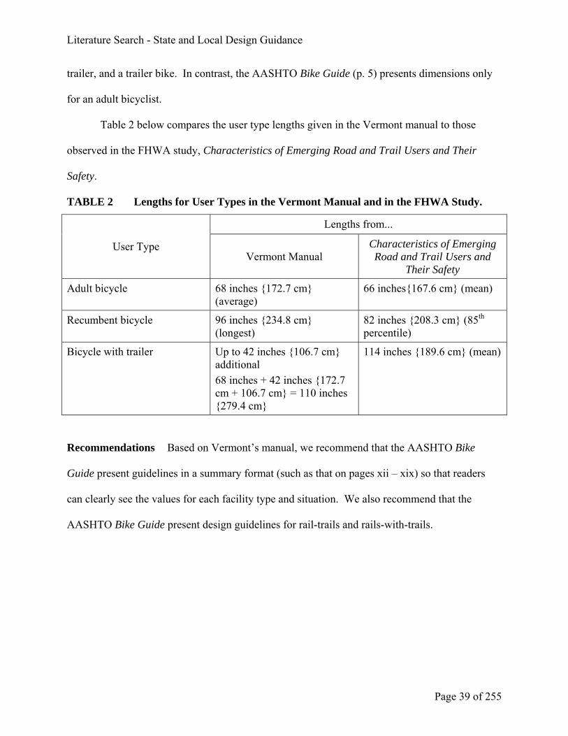
Table 2 below compares the user type lengths given in the Vermont manual to those
observed in the FHWA study, Characteristics of Emerging Road and Trail Users and Their
Safety.
TABLE 2 Lengths for User Types in the Vermont Manual and in the FHWA Study.
Lengths from...
User Type Vermont Manual
Characteristics of Emerging Road and Trail Users and
Their Safety
Adult bicycle 68 inches {172.7 cm} (average)
66 inches{167.6 cm} (mean)
Recumbent bicycle 96 inches {234.8 cm} (longest)
82 inches {208.3 cm} (85th percentile)
Bicycle with trailer Up to 42 inches {106.7 cm} additional 68 inches + 42 inches {172.7 cm + 106.7 cm} = 110 inches {279.4 cm}
114 inches {189.6 cm} (mean)
Recommendations Based on Vermont’s manual, we recommend that the AASHTO Bike
Guide present guidelines in a summary format (such as that on pages xii – xix) so that readers
can clearly see the values for each facility type and situation. We also recommend that the
AASHTO Bike Guide present design guidelines for rail-trails and rails-with-trails.

Literature Search - State and Local Design Guidance
Page 40 of 255
Document: Design Manual, Chapter 1020, “Bicycle Facilities” (Washington State
Department of Transportation)
Design Manual. Report No. M 22-01. Washington State Department of Transportation,
Olympia, WA, May 2001. Chapter 1020, “Bicycle Facilities” Available online at
http://www.wsdot.wa.gov/fasc/engineeringpublications/desEnglish/1020-E.pdf
Summary Chapter 1020 of Washington State’s Design Manual pertains to bicycle facilities.
It includes these sections:
1020.01 General
1020.02 References
1020.03 Definitions
1020.04 Planning
1020.05 Design
1020.06 Documentation
Comments The guidance in this chapter is consistent with that in the AASHTO Bike Guide.
Additional pavement width of up to 4 feet {1.2 m} is recommended on the inside of horizontal
curves to compensate for bicyclist lean (p. 1020-13). This chapter calls for combined
bicycle/parking lanes (without parking lines or stalls) to be a minimum of 12 feet {3.7} wide (pp.
1020-16 and 1020-20). In San Francisco, it was found that the 85th percentile of car doors
observed opened to 9.5 feet {2.9 m} from the curb (Alta Planning + Design, 2004), so the 12-
foot {3.7 m }width would give only bicyclists 2.5 feet {0.8 m} of space beyond the car doors.

Literature Search - State and Local Design Guidance
Page 41 of 255
The AASHTO Bike Guide (pp. 17-18) recommends a minimum of 12 feet {3.7 m} for a
combined bicycle/parking lane, but does not specify whether a parking stripe or stalls are
marked. Where parking is permitted but not marked with a stripe or stalls, the AASHTO Bike
Guide (pp. 22 and 24) recommends 11 feet {2.4 m} without a curb face, 12 feet {3.7 m}with a
curb face, and 13 feet {4.0 m}where there is substantial parking or high parking turnover.
Unlike the AASHTO Bike Guide, this chapter does not cover topics such as separation between
shared use paths and parallel roadways or safety considerations for shared use paths.
Chapter 915.08 covers bicycles at roundabouts and is consistent with Roundabouts: An
Informational Guide (Robinson et al., 2000).
Recommendation We do not recommend any specific changes to the AASHTO Bike Guide
based on the Washington Design Manual.

Literature Search - State and Local Design Guidance
Page 42 of 255
Document: Wisconsin Bicycle Facility Design Handbook
Wisconsin Bicycle Facility Design Handbook. Wisconsin Department of Transportation,
Madison, WI, January 2004. Available online at http://www.dot.state.wi.us/projects/state/
docs/bike-facility.pdf
Summary This handbook consists of four chapters and five appendices:
Chapter 1 Introduction
Chapter 2 Basic Roadway Improvements
Chapter 3 Bicycle Lanes
Chapter 4 Shared-use Paths
Appendix A Maintenance & Operations
Appendix B Traffic Conditions & Bridges
Appendix C Wisconsin Statutes
Appendix D Bibliography
Appendix E Index
Comments This handbook covers a comprehensive range of design topics and goes into
considerably more detail than the AASHTO Bike Guide. For example, pages 2-27 to 2-30 are
devoted to a discussion and illustrations of different loop detectors. Dozens of photographs
labeled “yes,” “OK,” or “no” illustrate good, okay, and bad design. The design guidelines are
further clarified by numerous drawings. According to the Acknowledgments, design manuals

Literature Search - State and Local Design Guidance
Page 43 of 255
from other states, the AASHTO Bike Guide, and the MUTCD were all consulted in the
preparation of this handbook.
The bicycle and bicyclist dimensions given on page 1-3 of the handbook are consistent
with those in the AASHTO Bike Guide (p. 5). Dimensions for tricycles and bicycles with trailers
are also mentioned (p. 1-2).
The widths of bicycle lanes and wide curb lanes are consistent with the AASHTO Bike
Guide.
Page 2-13 states that, “It is Wisconsin DOT policy to give strong consideration to bicycle
lanes and wide outside travel lanes on all urban cross-section projects.” By comparison, Florida
DOT no longer uses wide curb lanes in new construction.
The handbook also calls for the total width of a bicycle lane and an adjacent parking lane
to be a minimum of 13 feet {4.0 m} (pp. 3-10 to 3-11). In San Francisco, it was found that the
85th percentile of car doors observed opened to 9.5 feet {2.9 m} from the curb (Alta Planning +
Design, 2004), so the 13-foot width would give bicyclists 3.5 feet {1.1 m} of space beyond the
car doors. Page 3-11 of the handbook states that, “Combining bicycle lanes and parking lanes
without painting parking “T’s or striping between the two is found in some communities.
However, the undesignated space may look like a motor vehicle lane. As a result, it may be
preferable to identify the parking lane.”
The AASHTO Bike Guide (pp. 17-18) recommends a minimum of 12 feet {3.7 m} for a
combined bicycle/parking lane, but does not specify whether a parking stripe or stalls are
marked. Where parking is permitted but not marked with a stripe or stalls, the AASHTO Bike
Guide (pp. 22 and 24) recommends 11 feet {3.4 m} without a curb face, 12 feet {3.7 m} with a
curb face, and 13 feet {4.0 m} where there is substantial parking or high parking turnover.

Literature Search - State and Local Design Guidance
Page 44 of 255
The handbook (Section 4.3) does not go into as much detail as the AASHTO Bike Guide
(pp. 33-35 and 58) in its discussion of shared use paths adjacent to roadways and sidewalks used
as paths and does not have a separate section on mixing bicyclists and other users (Pp. 58-59 of
the AASHTO Bike Guide). Shared use path design elements such as width, horizontal clearance,
vertical clearance, design speed, horizontal alignment, grade, and stopping sight distance are
consistent with the AASHTO Bike Guide. The handbook (Section 4.15) goes into considerably
more detail than the AASHTO Bike Guide (pp. 46-54) in its discussion of shared use path –
roadway intersections.
Recommendation Based on the Wisconsin Bicycle Facility Design Handbook, we
recommend that the AASHTO Bike Guide include more photographs showing examples of good
design. The information in Wisconsin’s handbook also suggests that it may be appropriate for
the AASHTO Bike Guide to more thoroughly discuss combined bicycle/parking lane dimensions.
Additionally, the researchers recommend an expanded discussion of the application of wide curb
lanes.

Literature Search - National Guidance
Page 45 of 255
National Guidance
Document: An Informational Guide for Roadway Lighting
AASHTO. An Informational Guide for Roadway Lighting. Prepared by the Joint Task Force for
Highway Lighting of the AASHTO Highway Subcommittees on Design and Traffic Engineering.
American Association of State Highway and Transportation Officials, Washington, DC, 1984.
Summary This Guide contains information for the lighting of freeways, streets, tunnels and
underpasses, rest areas, and roadway signs.
Comments The Guide provides design values for both illuminance (defined as “the density of
the luminous flux incident on a surface”) and luminance (defined as “the luminous intensity of
any surface in a given direction per unit of project area of the surface as viewed from that
direction”). Table 2 (page 17) gives luminance values and Table 3 (page 18) gives horizontal
illuminance values. The values for separate bicycle facilities are found at the bottom of Table 3
(the Guide defines a bicycle lane as “any facility that explicitly provides for bicycle travel” and
does not specify on-road or off-road). For bicycle facilities that are adjacent to a roadway, the
luminance and illuminance values for that roadway classification should be used, as shown in
Tables 2 and 3.
Recommendation We recommend that the AASHTO Bike Guide include more detailed
information about lighting.

Literature Search - National Guidance
Page 46 of 255
Document: Bicycle Parking Guidelines
APBP. Bicycle Parking Guidelines. Association of Pedestrian and Bicycle Professionals.
Spring 2002. Available online at www.apbp.org/pdfs/bikepark.pdf.
Summary This document discusses the selection and placement of appropriate bicycle racks
for short-term bicycle parking. It covers the following components:
• The rack element – the part of the bike rack that supports one bicycle
• The rack
• The rack area – a bicycle parking lot
• The rack area site – the location of the rack area in relationship to a building entrance
Comments The APBP is also developing recommendations for long-term bicycle storage and
indoor bicycle parking, and for determining the appropriate number of bicycle parking spaces.
Recommendation Based on these guidelines, we recommend that the AASHTO Bike Guide
include a more thorough discussion, along with illustrations, of bicycle parking.

Literature Search - National Guidance
Page 47 of 255
Document: Collection of Cycle Concepts (Denmark)
Danish Road Directorate. Collection of Cycle Concepts. 2000. Available online at
http://www.vejdirektoratet.dk/pdf/cykelrapport/999Complete.pdf
Summary (copied from book) This book is primarily intended for traffic planners, but
may be read with advantage by anyone who is interested in cycling or other kinds of traffic, no
matter whether they are planners, engineers, road administrators, politicians or NGOs.
Bicycle traffic in the year 2000 gives a basic impression of what bicycle traffic is. The
chapter is supported by statistical data.
Bicycle traffic is more than cycle tracks is a process handbook for promoting more and
safer bicycle traffic. The chapter presents an overview of possibilities for new projects
and of the work processes involved.
Communication and campaigns describes effective ways of designing campaigns for both
more and safer bicycle traffic.
Urban planning describes links between land use and the volume of bicycle traffic. The
chapter presents preconditions of “the cycling town.”
Planning of traffic areas deals with the planning of cycle networks and the general
principles for choosing layout, cross section, speed limits, junction design and pavement.
Ways of financing plans and projects are also presented.
Design of traffic areas illustrates a large number of designs and describes their
advantages and disadvantages.

Literature Search - National Guidance
Page 48 of 255
Direction signing and cycle maps makes it easier to find the right roads, paths and
destinations. The chapter describes the Danish way of direction signing for cyclists and
walkers and drawing up cycle maps.
Bicycle parking treats the location, capacity and standards for bicycle parking.
Financing and protection against theft are also issues.
Road maintenance of cyclists’ traffic areas demonstrates the links between maintenance
quality and the promotion of safe bicycle traffic. Ways of raising maintenance quality
are described.
Roadworks illustrates the possibilities of ensuring good conditions for cyclists at
roadworks.
Collection of examples describes 8 demonstration projects that have received support
from the Ministry of Transport’s Traffic Pool. Many good ideas are shown.
From past to present recounts 100 years of Danish history about roads, paths and bicycle
traffic and puts forward some predictions on future traffic conditions.
Comments This book presents bicycle facilities planning and design from a Danish
perspective. Pages 63-100 cover “Design of Traffic Areas”: cycle lanes, paved shoulders, cycle
paths and tracks, junctions, and roundabouts. “Bicycle Parking” is covered in detail on pages
107-115, followed by “Road Maintenance” on pages 116-124.
Recommendations Based on the Collection of Cycling Concepts, we recommend a more
thorough discussion of bicycle parking and road maintenance in the AASHTO Bike Guide.

Literature Search - National Guidance
Page 49 of 255
Document: Recommended Lighting for Walkways and Class I Bikeways
Illuminating Engineering Society of North America. Recommended Lighting for Walkways and
Class 1 Bikeways. Report No. IESNA DG-5-94. August 1994.
Summary (copied from www. http://www.techstreet.com/cgi-bin/detail?product_id=14320)
This Design Guide consolidates references made in previous IESNA publications with certain
new information for designing lighting systems for walkways and Class I bikeways. It defines
pedestrian walkways by the method of separating the pedestrians from vehicular traffic. These
methods are horizontal, vertical, and temporal. As described here a bikeway is any road/path
open to bicycle travel -- shared (or not shared) with other transportation modes. There are three
classes of bikeways exclusive of pedestrians: Class I "Bike Path" (completely separated from
vehicular traffic); Class II "Bike Lane" (part of the roadway or shoulder); and Class III "Shared
Roadway" (right-of-way shared with motor vehicles).
Comments According to www.iesna.org, the Illuminating Engineering Society of North
America (IESNA) “is the recognized technical authority on illumination. For over ninety years
its objective has been to communicate information on all aspects of good lighting practice to its
members, to the lighting community, and to consumers through a variety of programs,
publications, and services.”
Recommendation We recommend that the AASHTO Bike Guide include a reference to this
Design Guide.

Literature Search - National Guidance
Page 50 of 255
Document: Bike Lane Design Guide
Nick Jackson and David Gleason. Bike Lane Design Guide. June 2002. Available online at
http://www.bicyclinginfo.org/pdf/bike_lane.pdf
Summary (copied from www.bicyclinginfo.org/de/bikelaneguide.htm) The
Pedestrian and Bicycle Information Center has teamed up with the City of Chicago and the
Chicagoland Bicycle Federation to publish a 48-page guide to signing, striping and marking
bike lanes on city streets. The guide contains 35 full-page technical drawings of street layouts,
striping patterns, signs, and street markings that show how the City of Chicago installs bike
lanes on streets as narrow as 44 feet {13.4 m} wide with parking on both sides. The guide
includes detailed information on how to address intersections, bus stops, and other tricky
situations.
The Guide also features 6 pages of answers to frequently asked questions about bike
lanes, a description of how the design guide was developed, and information about how your
city’s standards might differ from Chicago. The end result is a report that addresses every
reason, fear, excuse, or other barrier to getting bike lanes on your city’s streets.
Comments Although developed by the Chicago Department of Transportation, this guide is
intended to be applicable in cities, counties, and states nationwide. For the most part, the
guidance is consistent with the AASHTO Bike Guide. However, the City of Chicago does not
stripe bike lanes that are less than 5 ft {1.5 m} wide. It should be noted that this dimension can
include the width of the gutter pan; however, the Chicago Guide states a minimum 4 foot width
should be clear of all surface regularities. The guide advocates painting a stripe between the bike

Literature Search - National Guidance
Page 51 of 255
lane and the parking lane: "The striping encourages motorists to park closer to the curb and thus
provide more space for bicyclists in the bike lane, especially when they need to avoid an opening
car door. The striping discourages motorists from thinking that the shared bike/parking lane is in
fact a travel lane for motor vehicles, particularly when parking is relatively light and turnover is
high." (p. 5) Pages 7-42 consist of drawings showing bike lane striping and dimensions for a
variety of roadway widths, parking or no parking, intersection geometries, and signs and
markings.
The guide is limited to bike lanes. It does not cover shared use paths.
Recommendation Numerous survey respondents felt drawings such as those provided in this
document should be included within the next AASHTO Bike Guide. While we do not feel the
AASHTO Bike Guide should incorporate the drawings from this document, we do recommend
that the AASHTO Bike Guide include scale diagrams showing bike lane striping, signing, and
dimensions applicable to various intersections configurations. Additionally, we recommend
discussing various traffic operational factors that need to be analyzed (e.g., truck volumes, travel
speeds, signalization character, saturation flow rates, and motor vehicle LOS, as well as parking
turnover, door zone) when determining the cross section dimensions for general travel lanes,
bike lanes, and parking lanes. We recommend sample (clearly labeled as “sample”) drawings
from the centerline to edge of pavement be provided in the Guide.

Literature Search - National Guidance
Page 52 of 255
Document: Designing Sidewalks and Trails for Access – Part II of II: Best Practices Design
Guide
Kirschbaum, Julie B., Peter W. Axelson, Patricia E. Longmuir, Kathleen M. Mispagel, Julie A.
Stein, and Denise A. Yamada. Designing Sidewalks and Trails for Access - Part II of II: Best
Practices Design Guide. Report No. FHWA-EP-01-027. Federal Highway Administration,
Washington, DC, September 2001. Available online at http://www.fhwa.dot.gov/environment/
sidewalk2/index.htm
Summary (excerpted from Introduction and Chapter 14) This guidebook is the second
part of a two-phase project focused on designing sidewalks and trails for access. It was created to
provide planners, designers, and transportation engineers with a better understanding of how
sidewalks and trails should be developed to promote pedestrian access for all users, including
people with disabilities. Part I, A Review of Existing Guidelines and Practices, is a compilation
of data and designs gathered during a comprehensive literature search and site visits conducted
throughout the United States. Many of the recommendations provided in this guidebook are
based on research gathered during Phase I.
For this report, the majority of the accessibility recommendations for shared-use paths are
based on the 1999 AASHTO Guide for the Development of Bicycle Facilities (AASHTO, 1999).
Additional issues, such as protruding objects (that are not addressed in the AASHTO bicycle
facility guide) are also included in this report. However, the recommendations for grade in this
report are based on the work by the Regulatory Negotiation Committee for Outdoor Developed

Literature Search - National Guidance
Page 53 of 255
Areas because the maximum grades identified for bicyclists in the AASHTO bicycle facility
guide do not provide access to many people with mobility impairments.
COMMENTS
Comments This guidebook acknowledges the potential for conflicts among users of shared
use paths and suggests how to reduce conflicts (Section 14.3).
Section 14.5 of this guidebook recommends shorter grades than those in the AASHTO
Bike Guide (p. 39) (Table 3).
TABLE 3 Recommended Grades in the AASHTO Bike Guide and Designing Sidewalks
and Trails for Access.
AASHTO AASHTO Designing Sidewalks and Trails for Access
Designing Sidewalks and Trails for Access
Grade Length (maximum) Grade Length (maximum) 5-6% 800 ft {240 m} 7% 400 ft {120 m} 8% 300 ft {90 m} 9% 200 ft {60 m} 8.3% 200 ft {61 m} 10% 100 ft {30 m} 11+% 50 ft {15 m} 10% 30 ft {9.14 m} 12.5% 10 ft {3.05 m}
Chapter 16 addresses trail crossings: trail-trail, bridges, trail-street/roadway, grade-
separated crossings, and railroad crossings.
Recommendation We recommend that the AASHTO Bike Guide include a discussion of the
impact of grades on persons with disabilities. Also, we recommend that the AASHTO Bike
Guide refer interested readers to Designing Sidewalks and Trails for Access.

Literature Search - National Guidance
Page 54 of 255
Document: Roundabouts: An Informational Guide
Bruce W. Robinson, Lee Rodegerdts, Wade Scarborough, Wayne Kittelson, Rod Troutbeck,
Werner Brilon, Lothar Bondzio, Ken Courage, Michael Kyte, John Mason, Aimee Flannery,
Edward Myers, Jonathan Bunker, and Georges Jacquemart. Roundabouts: An Informational
Guide. Federal Highway Administration, McLean, VA, June 2000.
Abstract (copied from report) The guidance supplied in this document is based on
established international and U.S. practices and is supplemented by recent research. The guide
is comprehensive in recognition of the diverse needs of transportation professionals and the
public for introductory material through design detail, as well as the wide range of potential
applications of roundabout intersections. The following topics are addressed: definition of a
roundabout and what distinguishes roundabouts from traffic circles; public acceptance and legal
issues associated with roundabouts; consideration of all user modes, including heavy vehicles,
buses, transit, bicycles, and pedestrians; a methodology for identifying appropriate sites for
roundabouts and the range of conditions for which roundabouts offer optimal performance;
methodologies for estimating roundabout capacity, delays, and queues with reference to the
"Highway Capacity Manual"; design principles and guidance on safety and geometric design,
with reference to applicable national standards such as the AASHTO "Policy on Geometric
Design of Highways and Streets"; guidelines for control features such as signing and pavement
markings, with reference to the "Manual on Uniform Traffic Control Devices"; illumination; and
landscaping.

Literature Search - National Guidance
Page 55 of 255
Comments Section 5.2.3 discusses bicycle-motor vehicle and bicycle-pedestrian conflicts at
roundabouts. Bicyclist crash data from European roundabouts are presented in Section 5.3.4.
Design provisions for bicycles are given in Section 6.3.12 and can be summarized as follows
(see also Figure 2):
• Terminate bicycle lanes prior to a roundabout, 100 ft {30 m} upstream of the yield line to
allow for merging with vehicles.
• Provide a widened sidewalk or a shared bicycle/pedestrian path for bicyclists who prefer
not to use the roadway while going around the roundabout. Provide ramps so that
bicyclists can get on and off the sidewalk or shared path.
Figure 2. Possible provisions for bicycles at roundabouts.
The AASHTO Bike Guide (p. 64) recommends discontinuing bike lanes, 35 to 65 feet
{10 to 20 m}, upstream of the roundabout. It also suggests shared use of the pedestrian facility
as a solution at higher-speed, multi-lane roundabouts.

Literature Search - National Guidance
Page 56 of 255
Recommendation We recommend the inclusion of drawings illustrating the roundabout
recommendations in the AASHTO Bike Guide.

Literature Search - National Guidance
Page 57 of 255
Document: Highway Capacity Manual
Transportation Research Board. Highway Capacity Manual. Transportation Research Board,
Washington, DC, 2000, Chapter 19 (Bicycles).
Summary (copied from Introduction) This chapter addresses the capacity and level-of-
service (LOS) analysis of facilities serving bicycles. Specifically, procedures are provided for
the following types of facilities:
• Exclusive off-street bicycle paths: paths physically separated from highway traffic for
the exclusive use of bicycles;
• Shared off-street paths: paths physically separated from highway traffic for the use of
bicycles, pedestrians, skateboards, roller skaters, in-line skaters, and other nonmotorized
traffic;
• Bicycle lanes on streets: designated bicycle lanes on urban streets, usually directly
adjacent to highway traffic lanes, operating under interrupted flow;
• Interrupted-flow bicycle facilities: designated bicycle lanes on streets, usually directly
adjacent to highway traffic lanes, operating through fixed interruptions such as traffic
signals and stop signs; and
• Bicycle lanes on urban streets: designated bicycle lanes on urban streets, incurring the
impact of both uninterrupted-flow sections and fixed interruptions.

Literature Search - National Guidance
Page 58 of 255
Comments The procedures for exclusive off-street bicycle paths, shared off-street paths and
on-street bicycle lanes (“Uninterrupted-Flow Bicycle Facilities,” pp. 19-1 to 19-5) are those
recommended by Allen et al. (1998). The LOS for on-street bicycle lanes is dependent on the
number of events, which vary according to the bicycle flow rate, mean speed, and standard
deviation of the speed.
For interrupted-flow bicycle lanes (pp. 19-5 to 19-8), the LOS depends on control delay
at signalized and stop-controlled (on the minor street only, not all-way stop) intersections. As
the length of delay increases, the LOS deteriorates from A to F. For bicycle lanes on urban
streets (intersections plus segments), the LOS depends on average bicyclist speeds. As speeds
decrease, the LOS deteriorates from A to F.
Recommendation Based on the Highway Capacity Manual, we do not recommend any
specific changes to the AASHTO Bike Guide.

Literature Search - National Guidance
Page 59 of 255
Document: Trail Intersection Design Handbook
UNC-HSRC. Trail Intersection Design Handbook. Florida Department of Transportation, 1996.
Available online at http://www.dot.state.fl.us/Safety/ped_bike/handbooks_and_research/
research/trailint.pdf
Summary (first paragraph copied from http://www.dot.state.fl.us/Safety/ped_bike/
ped_bike_standards.htm) This handbook discusses design processes and principles of
designing trail/roadway intersections. It includes information on various crossing types,
regulating traffic and site design. This handbook also reviews some European trail crossing
guidelines. Guidelines from the Netherlands and development of a bicycle crossing time equation
are included in the appendices.
The Introduction (Chapter 1) discusses the need for, and development of, this handbook.
Chapter 2, “Background essentials,” contains sections on the design trail user, the design
process, and design principles. Design elements are covered in Chapter 3, which contains
sections on crossing types (midblock, parallel path, and complex intersection), regulating traffic,
sight distance, refuge areas, and additional considerations (access control, pavement markings,
crosswalk striping, texture change, lighting, and curb cuts).
Comments The information in this handbook is based on
• A literature review of designs and standards in use in the U.S. and abroad
• The author’s principles of bicycle-friendly design
• Observations of 60 trail-roadway and trail-driveway junctions throughout Florida

Literature Search - National Guidance
Page 60 of 255
Recommendation We recommend an expanded discussion of trail/roadway intersections in
the AASHTO Bike Guide.

Literature Search - National Guidance
Page 61 of 255
Document: Selecting Roadway Design Treatments to Accommodate Bicycles
W.C. Wilkinson, III, A. Clarke, B. Epperson, and R. Knoblauch. Selecting Roadway Design
Treatments to Accommodate Bicycles. Report No. FHWA-RD-92-073. Federal Highway
Administration, McLean, VA, January 1994. Available online at
http://safety.fhwa.dot.gov/fourthlevel/pdf/Select.pdf (text) and
http://safety.fhwa.dot.gov/fourthlevel/pdf/Tables.pdf (tables)
Abstract (copied from report) This manual is designed to assist transportation planners
and engineers in selecting roadway design treatments to accommodate bicycles. This is the first
attempt to provide comprehensive guidelines for this process. The recommendations are based
on assumptions regarding policy goals and the types of bicyclists to be accommodated, the state
of the practice, and professional judgment. More research, testing, and evaluation are needed to
assess and refine these recommendations. A more detailed final report on this study is available.
This manual is not intended to serve as a comprehensive guide to the design of bicycle facilities.
The user is referred to the current edition of the American Association of State Highway and
Transportation Officials' "Guide to the Development of Bicycle Facilities" for detailed
specifications. The manual describes the assumptions, principles, and approaches used to
develop the recommendations; provides a model planning process for identifying a network of
routes on which designated bicycle facilities should be provided to accommodate bicyclists of
moderate ability (casual adult riders and children); and recommends design treatments and
specifications for roadways to serve different types of bicyclists under various sets of traffic

Literature Search - National Guidance
Page 62 of 255
operational factors. The appendix contains a detailed discussion of the various types of bicycle
facilities.
Comments The Appendix to this manual contains six tables that list recommended bicycle
facility types (wide curb lane, shoulder, shared lane, and bike lane) for varying average speeds,
AADT, and adequate/inadequate sight distance for the following situations:
Table 1 – Group A bicyclists, urban section, no parking
Table 2 – Group A bicyclists, urban section, with parking
Table 3 – Group A bicyclists, rural section
Table 4 – Group BC bicyclists, urban section, no parking
Table 5 – Group BC bicyclists, urban section, with parking
Table 6 – Group BC bicyclists, rural section
Recommendation This document is referenced in the current edition of the AASHTO Bike
Guide. Based on Selecting Roadway Design Treatments to Accommodate Bicycles, we do not
recommend any specific changes to the AASHTO Bike Guide. This document represented the
consensus of the authors at the time it was produced. With recent developments in measures of
bicycle accommodation (BCI and Bicycle LOS), the tabular method is used less now than in
earlier years. However, while we do not feel this document should be specifically mentioned in
the main text of the AASHTO Bike Guide, we suggest that this document be included merely as
an endnote in the AASHTO Bike Guide in the section concerning the selection of bicycle
facilities using the functional classification of the roadway.

Literature Search - National Guidance
Page 63 of 255
Document: Safety Effects of Marked vs. Unmarked Crosswalks at Uncontrolled Locations
Charles V. Zegeer, J. Richard Stewart, Herman F. Huang, and Peter A. Lagerwey. Safety Effects
of Marked vs. Unmarked Crosswalks at Uncontrolled Locations - Executive Summary and
Recommended Guidelines. Report No. FHWA-RD-01-075. Federal Highway Administration,
McLean, VA, April 2001.
Abstract (copied from Report) Pedestrians are legitimate users of the transportation
system, and they should, therefore, be able to use this system safely. Pedestrian needs in crossing
streets should be identified, and appropriate solutions should be selected to improve pedestrian
safety and access. Deciding where to mark crosswalks is only one consideration in meeting that
objective. This study involved an analysis of 5 years of pedestrian crashes at 1,000 marked
crosswalks and 1,000 matched unmarked comparison sites. All sites in this study had no traffic
signal or stop sign on the approaches. Detailed data were collected on traffic volume, pedestrian
exposure, number of lanes, median type, speed limit, and other site variables. Poisson and
negative binomial regressive models were used.
The study results revealed that on two-lane roads, the presence of a marked crosswalk
alone at an uncontrolled location was associated with no difference in pedestrian crash rate,
compared to an unmarked crosswalk. Further, on multi-lane roads with traffic volumes above
about 12,000 vehicles per day, having a marked crosswalk alone (without other substantial
improvements) was associated with a higher pedestrian crash rate (after controlling for other
site factors) compared to an unmarked crosswalk. Raised medians provided significantly lower

Literature Search - National Guidance
Page 64 of 255
pedestrian crash rates on multi-lane roads, compared to roads with no raised median. Older
pedestrians had crashes that were high relative to their crossing exposure.
More substantial improvements were recommended to provide for safer pedestrian
crossings on certain roads, such as adding traffic signals with pedestrian signals when
warranted, providing raised medians, speed-reducing measures, and others.
Comments The authors recommended many potential countermeasures to improve pedestrian
safety related to crossing streets, instead of merely adding a marked crosswalk. Improvements
on multi-lane roads include adding pedestrian signals, installing raised medians or refuge islands,
improving nighttime lighting, providing curb extensions, providing tighter turning radii (to
shorten crossing distances and lower the speeds of right-turning motorists), reducing the number
of lanes, and providing advance stop lines (to improve sight distance between motorists and
pedestrians in crosswalks). Improvements on two-lane roads include narrowing travel lanes,
removing parking near the intersection, improving lighting, adding signals, and providing traffic
calming measures (on residential streets).
Recommendation Based on this report, we recommend that the AASHTO Bike Guide
include a discussion of the use of crosswalks as a possible treatment for the intersection of
shared-use paths with roadways. This discussion should include options for when a crosswalk
alone is not adequate to provide a safe crossing treatment for shared use path users.

Literature Search - Synthesis of Practice
Page 65 of 255
Synthesis of Practice
Document: Bicycle Facility Selection: A Comparison of Approaches
Michael King. Bicycle Facility Selection: A Comparison of Approaches. Prepared for the
Pedestrian and Bicycle Information Center. Available online at http://www.bicyclinginfo.org/de/
bike_selection.htm
Summary The author reviewed bicycle facility guidelines from local, state, and national
agencies in North America (10), Europe (4), and Australia (2). These are summarized in a series
of matrices, one for each guideline, according to motor vehicle speeds and volumes. Facility
definitions varied among guidelines, but for purposes of comparison were classified as follows:
Narrow lane 9-12 feet {2.7-3.7 m} wide
Wide lane 13-15 feet {4-4.6 m} wide
Bike lane 4-6 feet {1.2-1.8 m} wide and striped
Separated lane Anything wider than a 6-foot {1.8 m} on-street bike lane
Examples of each facility type are shown in Figures 8-29 of the report.
The facility guidelines varied considerably among agencies. For example, if a street has
a speed of 25 mi/h {40 km/h} and 4,000 ADT, the guidelines call for a narrow lane in Germany,
a wide lane in Minnesota, and a bike lane in the City of Cambridge, MA.
Speed-volume matrices were developed for each LOS, A through F, using the Bicycle
Compatibility Index. The speed and volume boundaries of each guideline were then compared
to the speed-volume matrices to determine the LOS. North American guidelines generally
provided for LOS D, while European and Australian guidelines provided for LOS C. With

Literature Search - Synthesis of Practice
Page 66 of 255
regard to facility type, narrow and wide lanes usually provided for LOS D, bike lanes provided
for LOS C, and separated lanes provided for LOS B.
Comments This report is a synthesis of existing guidelines. The 4- to 6-foot {1.2 m to 1.8 m}
width used for bike lanes in the author’s classification scheme is consistent with the AASHTO
Bike Guide (pp. 22-23). The recommended 14-foot width for wide curb lanes (p. 17) is in the
13- to 15-foot {4 m to 4.6 m} range for wide lanes in the classification scheme.
Recommendation We do not recommend any specific changes to the AASHTO Bike Guide,
based upon this document. With recent developments in measures of bicycle accommodation
(BCI and Bicycle LOS), the other selection methods described in this document are used less
frequently than in the past.

Literature Search - Synthesis of Practice
Page 67 of 255
Document: Conflicts on Multiple-Use Trails: Synthesis of the Literature and State of the
Practice
Roger L. Moore. Conflicts on Multiple-Use Trails: Synthesis of the Literature and State of the
Practice. Report No. FHWA-PD-94-031. Federal Highway Administration, Washington, DC,
August 1994. Available online at http://www.fhwa.dot.gov/environment/conflicts/
Abstract (copied from report) The National Recreational Trails Advisory Committee
identified trail-user conflicts on multiple-use trails as a major concern that needs resolution. The
Committee asked the Federal Highway Administration to produce a synthesis of the existing
research to foster understanding of trail conflict, identify approaches for promoting trail-
sharing, and identify gaps in current knowledge. This synthesis is intended to establish a
baseline of the current state of knowledge and practice and to serve as a guide for trail
managers and researchers. The goal of the report is to promote user safety, protect natural
resources, and provide high-quality user experiences. It reviews management options such as
trail design, information and education, user involvement, and regulations and enforcement.
Trail conflicts can occur among different user groups, among different users within the
same user group, and as a result of factors not related to trail user activities at all. Conflict has
been found to be related to activity style, focus of trip, expectations, attitudes toward and
perceptions of the environment, level of tolerance for others, and different norms held by
different users.

Literature Search - Synthesis of Practice
Page 68 of 255
The report provides 12 principles for minimizing conflicts on multiple-use trails.
1. Recognize conflict as goal interference
2. Provide adequate trail opportunities
3. Minimize number of contacts in problem areas
4. Involve users as early as possible
5. Understand user needs
6. Identify the actual sources of conflict
7. Work with affected users
8. Promote trail etiquette
9. Encourage positive interaction among different users
10. Favor “light-handed management”
11. Plan and act locally
12. Monitor progress
Although this report is about conflicts on trails, it is intended to promote cooperation and
understanding among trail users and to inspire ideas that will help reduce trail conflict. It is
intended to be used by trail managers, State and local trail coordinators, researchers, and trail-
user volunteer organizations.
Comments The author presents a variety of strategies – including design, education,
regulations, and enforcement – that others have used or suggested as means to avoid or minimize
conflicts. The design strategies are general and do not provide any specific guidance.

Literature Search - Synthesis of Practice
Page 69 of 255
Recommendation We do not recommend any specific changes to the AASHTO Bike Guide
based on this report.

Literature Search - Synthesis of Practice
Page 70 of 255
Document: Innovative Bicycle Treatments: An Informational Report
Jumana Nabti, Matthew Ridgway, and the ITE Pedestrian and Bicycle Council. Innovative
Bicycle Treatments: An Informational Report. Institute of Transportation Engineers,
Washington, DC, 2002.
Summary (excerpted from Executive Summary) Approximately 50 treatments are
summarized in this report. These treatments include on-street innovations such as contra-flow
bike lanes, shared bike/bus lanes, bike boulevards, raised bike lanes and colored bike lanes.
There is information on trail facilities including one-way trails and median trails. This technical
report, which is divided into eight sections, also summarizes treatments for bicycles at
intersections, bicycle detection, unique bicycle signs, traffic calming accommodations for
bicycles and bicycle parking.
The intent of this report is to identify innovations and share information on their
applications, advantages and disadvantages; this report does not necessarily encourage or
discourage their use.
Comments The main part of this report does not provide design guidance. However, the
Appendix includes a 1994 report prepared by W.C. Wilkinson et al. for FHWA, Selecting
Roadway Design Treatments to Accommodate Bicycles.
Recommendation Based on this report, we do not recommend any specific changes to the
AASHTO Bike Guide.

Literature Search – Research on Bicycle Facilities and Users
Page 71 of 255
Research on Bicycle Facilities and Users
Document: Operational Analysis of Uninterrupted Bicycle Facilities
D. Patrick Allen, Nagui Rouphail, Joseph E. Hummer, and Joseph S. Milazzo II. Operational
Analysis of Uninterrupted Bicycle Facilities. Transportation Research Record 1636,
Transportation Research Board, Washington, DC, 1998, pp. 29-36.
Abstract (copied from paper) The popularity of bicycles in North America is growing. As
the popularity of bicycles has increased, so has the physical network of separate bicycle facilities
and designated bicycle lanes in many locations. As a consequence of this growth, there is a
demand for more information about bicycle operations on these facilities. Unfortunately, the
state of knowledge regarding bicycle operations in the United States currently lags far behind
that of motor vehicles and pedestrians. The international research that has been conducted to
date regarding bicycle operations on uninterrupted facilities is thoroughly reviewed, and
recommended procedures for the operational analysis of uninterrupted bicycle facilities are
outlined. The recommended procedures are based on the concept of "frequencies of events"
involving a bicyclist and other bicyclists or facility users. Events are defined as bicycle
maneuvers required by a bicyclist on a facility, including passings (same-direction encounters)
and meetings (opposite-direction encounters). The frequency of events for an uninterrupted
bicycle facility is related to the service volumes of bicycles using or projected to be using the
facility and does not have to be observed directly. The proposed procedures are, therefore,
recommended based not only on their theoretical substance but also on their ease of use by
practitioners.

Literature Search – Research on Bicycle Facilities and Users
Page 72 of 255
Comments The authors categorized uninterrupted bicycle facilities as exclusive paths, shared
off-street paths (corresponding to shared use paths in the AASHTO Bike Guide), and on-street
facilities (corresponding to bike lanes, paved shoulders, and wide curb lanes).
The analysis relies on equations originally proposed by Hein Botma. The level of service
(LOS) depends on the number of events experienced by bicyclists. An event occurs when one
user passes another user traveling in the same direction, or when one user meets another user
traveling in the opposite direction.
The authors present equations for calculating the number of events on one- and two-way
shared use paths, and one- and two-way exclusive paths. The equations for shared use paths
assume that bicycle and pedestrian speeds are normally distributed with means of 11 mi/h {18
km/h} and 2.8 mi/h {4.5 km/h} respectively.
For example, Table 4 below shows the LOS thresholds (expressed as events per hour) are
roughly twice as high for a 10-foot {3.0-m} path, compared to an 8-foot {2.4- m} path. Ten-foot
{3.0-m} paths are regarded as operating with three lanes, and 8-foot {2.4- m} paths operate with
two lanes.
TABLE 4 LOS Thresholds for 8-ft {2.4-m} and 10-ft {3.0-m} Paths.
LOS Events/hr for 8-ft {2.4 m}paths (2-
lane) Events/hr for 10-ft {3.0-m}paths
(3-lane)
A <40 <90
B <60 <140
C <100 <210
D <150 <300
E <195 <375
F ≥195 ≥375

Literature Search – Research on Bicycle Facilities and Users
Page 73 of 255
Recommendation The results of this study support the recommended 10-ft (instead of 8-ft)
width for a shared use path, so we do not recommend any specific changes to the AASHTO Bike
Guide. However, we recommend that the AASHTO Bike Guide include this study as a
reference, as it will likely impact the Highway Capacity Manual.

Literature Search – Research on Bicycle Facilities and Users
Page 74 of 255
Document: San Francisco’s Shared Lane Pavement Markings: Improving Bicycle Safety
Alta Planning + Design. San Francisco’s Shared Lane Pavement Markings: Improving Bicycle
Safety. Final Report. Submitted to San Francisco Department of Parking and Traffic, February
2004. Available online at http://bicycle.sfgov.org/site/uploadedfiles/dpt/bike/Bke_Plan/
Shared%20Lane%20Marking%20Full%20Report-052404.pdf
Summary The San Francisco Department of Parking & Traffic (DPT) evaluated two shared-
use arrow designs: a “bike-in-house” marking and a bike-and-chevron marking (Figures 3 and
4).
Figure 3. “Bike-in-house” marking.
Figure 4. Bike-and-chevron marking.

Literature Search – Research on Bicycle Facilities and Users
Page 75 of 255
The evaluation took place on six streets, with the bike-in-house markings on one side and
the bike-and-chevron marking on the other side. Bicyclists and motorists were videotaped and
their positions were recorded.
The goals and findings below are copied from the report.
Goal 1: Improve the position of both bicyclists and motorists on roadways without
bicycle lanes
• Overall, the presence of a marking increased the distance of cyclists to parked
cars by 8 inches {20.3 cm}. The effect of each marking on position was similar.
• When passing vehicles were present, the markings caused an increase of 3 to 4
inches {7.6 to 10.1 cm} in the distance between cyclists and parked cars. In
addition, the markings caused an increase of over 2 feet {0.6 m} in the distance
between cyclists and passing vehicles. The bike-and-chevron had a greater effect
(by 3 inches {7.6 cm}) on the distance between cyclists and passing vehicles.
• When no cyclists were present, both of the markings had a significant positive
effect of about one foot on the distance between passing vehicles and parked cars.
Goal 2: Reduce aggressive motorist behavior
• The markings neither significantly reduced nor increased the number of
observable hostile behaviors between bicyclists and motorists. This was
primarily due to the low number of aggressive behaviors recorded in the "before"
videotapes.
Goal 3: Encourage correct bicyclist riding behavior
• Both the markings significantly reduced the number of sidewalk riders: the bike-
and chevron by 35% and the bike-in house by 25%.

Literature Search – Research on Bicycle Facilities and Users
Page 76 of 255
• The bike-and-chevron marking significantly reduced the number of wrong-way
riders by 80%. The bike-in-house marking did not have any significant impact on
the percentage of wrong-way riders.
The project team concluded that both types of shared lane markings had a positive impact
on motorist and bicyclist behavior, positions, and safety. The bike-and-chevron marking had a
stronger impact on motorist positioning and in reducing wrong-way riding, and was preferred by
the cyclists who were surveyed. Therefore, the project team recommended that the bike-and-
chevron marking be used in San Francisco.
Comments The shared-use arrows were placed so that the centerlines were 11 feet {3.4 m}
from the curb. This placement accommodates open car doors from cars parked along the curb
(the 85th percentile of car doors observed opened to 9.5 feet {2.9 m} from the curb) and a 6-inch
{20 cm} minimum shy distance between car doors and bicycle handlebars.
From the photographs in the report, it appears that most locations do not have parking
stripes or stalls.
Recommendations Based on the results of this study, we do not recommend the inclusion of
either shared lane marking in the AASHTO Bike Guide, unless they are adopted in the MUTCD.

Literature Search – Research on Bicycle Facilities and Users
Page 77 of 255
Document: Sidewalk Bicycling Safety Issues
Lisa Aultman-Hall and Michael F. Adams, Jr. Sidewalk Bicycling Safety Issues.
Transportation Research Record 1636, Transportation Research Board, Washington, DC, 1998,
pp. 71-76.
Abstract (copied from paper) Bicycle route and safety data sets for 2,963 commuter
cyclists in Ottawa and Toronto, Canada, containing cyclist characteristics, collision and fall
history, and regular commute route, are used for this analysis. Previous analyses found sidewalk
collisions and fall and injury rates significantly higher on sidewalks than on roads or paths. Of
the 52 events reported on sidewalks, none were reported to police and would, therefore, not be
found in a police accident database. These events did result in injuries, and in two cases major
injuries. This analysis has found that commuter cyclists in Ottawa use sidewalks primarily on
major roads (not necessarily high-speed roads) and often to cross bridges or to take shortcuts
where no road exists. Toronto commuter cyclists use sidewalks primarily on high-volume
multilane roads. Some Toronto cyclists still use sidewalks when bicycle lanes are provided. A
slightly higher proportion of women are sidewalk cyclists in Ottawa; however, no age
relationship was found. Sidewalk cyclists reported proportionally more near misses with bicycles
in the previous month. A relatively large number of sidewalk collisions are with other bicycles.
The most significant result of the analysis is that sidewalk cyclists have higher event rates on
roads than nonsidewalk cyclists.

Literature Search – Research on Bicycle Facilities and Users
Page 78 of 255
Comments The authors remark that “The reasons for the higher rate of collisions, falls, and
injury on roads by sidewalk cyclists were not measured in the data set.” (p. 75) They also note
that “The nonsidewalk cyclists in Ottawa did have more total travel experience, which may
correspond to better cycling skills.” (p. 75) The higher rate of events encountered by sidewalk
cyclists may be due to a combination of the potential for conflicts (as described in the AASHTO
Bike Guide, p. 58) and a lack of experience.
Recommendation Based on the results of this study, we recommend that the AASHTO Bike
Guide strongly discourage the designation of sidewalks as bicycle facilities.

Literature Search – Research on Bicycle Facilities and Users
Page 79 of 255
Document: Development of the Bicycle Compatibility Index
David L. Harkey, Donald W. Reinfurt, and Matthew Knuiman. Development of the Bicycle
Compatibility Index. Transportation Research Record 1636, Transportation Research Board,
Washington, DC, 1998, pp. 13-20.
Abstract (copied from paper) Presently, there is no methodology that is widely accepted
by engineers, planners, or bicycle coordinators that will allow them to determine how
compatible a roadway is for allowing efficient operation of both bicycles and motor vehicles.
Determining how existing traffic operations and geometric conditions affect a bicyclist's decision
to use or not use a specific roadway is the first step in determining the bicycle compatibility of
the roadway. The Federal Highway Administration sponsored a study in which a methodology
for deriving a bicycle compatibility index was developed. This tool can be used by bicycle
coordinators, transportation planners, traffic engineers, and others to evaluate the capability of
specific roadways to accommodate both motorists and bicyclists. It is intended to provide
practitioners with the ability to assess the bicycle level of service present on existing facilities or
on proposed facilities and can be used for operational, design, and planning analyses.
Comments A video methodology was used to develop the Bicycle Compatibility Index (BCI).
Participants viewed roadway segments on videotape and rated the segments with respect to how
comfortable they would be riding a bicycle on those segments. The videotape included video
clips from 67 roadway segments in cities across the U.S. The geometric and operational
characteristics varied considerably across the segments:

Literature Search – Research on Bicycle Facilities and Users
Page 80 of 255
• Curb lane widths ranged from 9.8 to 15.4 ft {3.0 to 4.7 m}
• 85th percentile motor vehicle speeds ranged from 24.8 to 55.3 mi/h {40 to 89 km/h}
• Traffic volumes ranged from 2,000 to 60,000 vehicles per day
• Bicycle lane and paved shoulder widths ranged from 2.9 to 8.0 ft {0.92 to 2.44 m}
As shown in Figure 5, the BCI model incorporates bicycle lane (or paved shoulder) width, curb
lane width, and other geometric and operational variables.
Figure 5. Bicycle Compatibility Index model, variable definitions, and adjustment factors.
The model shows that, holding other variables constant, the addition of a bike lane or
paved shoulder of at least 3.0 ft {0.9 m}, reduces the BCI (i.e., bicyclists will feel more
comfortable) by 0.966 plus 0.410 times the width (in meters) of the bike lane or paved shoulder.

Literature Search – Research on Bicycle Facilities and Users
Page 81 of 255
The addition of a paved shoulder of less than 2.9 ft {0.9 m} will reduce the BCI by 0.410 times
the width (in meters). This supports the statement in the AASHTO Bike Guide (p. 16) that “any
additional shoulder width is better than none at all.” This also suggests that 2.9 ft {0.9 m} is a
minimum width, below which bicyclists do not perceive the bike lane (or paved shoulder) as
being “present.”
A serious disadvantage of the video methodology is that participants are not riding actual
roadway segments. Therefore, their ratings reflect perceived comfort and not real-life,
experienced comfort. The Bicycle Level of Service by Landis et al. (1997 and 2003) addresses
this shortcoming.
Recommendation Based on the results of this study, we recommend that the AASHTO Bike
Guide be updated to discuss the BCI and the factors that were found to influence cyclists’
perceptions of how comfortable they felt riding along roadways. The BCI research also suggests
that the AASHTO Bike Guide should discuss minimum bike lane widths of 3 feet {0.9 m}.

Literature Search – Research on Bicycle Facilities and Users
Page 82 of 255
Document: Evaluation of Shared-Use Facilities for Bicycles and Motor Vehicles
David L. Harkey and J. Richard Stewart. Evaluation of Shared-Use Facilities for Bicycles and
Motor Vehicles. Transportation Research Record 1578, Transportation Research Board,
Washignton, DC, pp. 111-118.
Abstract (copied from paper) This study was conducted for the Florida Department of
Transportation with an objective of evaluating the safety and utility of shared-use facilities to
provide engineers and planners comprehensive results that can be used in planning, designing,
and constructing roadways to be shared by motorists and bicyclists. The results were developed
from an analysis of observations of bicyclists and motorists interacting on different types of
roadways. The evaluation included roadways with wide curb lanes, bicycle lanes, and paved
shoulders. Locations from both rural and urban environments were included and varied in terms
of motor-vehicle speed, traffic volume, lane width, and number of lanes. The operational
measures of effectiveness used in evaluating the different types of facilities included (a) lateral
placement of the bicyclist, (b) lateral placement on the motor vehicle, (c) separation distance
between the bicycle and motor vehicle, and (d) encroachments by the motorist or bicyclist during
the passing maneuver. Results of the analysis showed that the type of facility (wide curb lane
versus bicycle lane versus paved shoulder) does have a significant effect on the separation
distance between bicyclists and motor vehicles; this distance ranged from 5.9 to 6.4 ft {1.80 to
1.95 m}. The findings also indicated that paved shoulders and bicycle lanes generally result in
similar interactions between motorists and bicyclists and that when compared with wide curb
lanes they offer some distance advantages to both user groups. The results also indicated that

Literature Search – Research on Bicycle Facilities and Users
Page 83 of 255
bicycle lanes as narrow as 3 ft {0.92 m} provide sufficient space for motorists and bicyclists to
interact safely. At the same time, a 4-ft {1.22-m} wide bicycle lane tended to optimize operating
conditions because there were very few differences in the measures of effectiveness when 4-ft
{1.22-m} lanes were compared with wider lanes.
Comments The authors suggested that motorists were willing to accept a slightly smaller
separation distance when passing bicyclists when there is a stripe on the roadway designating
distinct areas for motorists and bicyclists. Motorists were less likely to encroach into the
adjacent lane when passing a bicyclist on roads with paved shoulders or bicycle lanes. Other
studies have found that bicyclists are more comfortable riding on roads with bicycle lanes or
paved shoulders, due to the presence of the stripe (Harkey et al., 1998; Landis et al., 1997).
Recommendation Based on the results of this study, we recommend that the AASHTO Bike
Guide should discuss minimum bike lane widths of 3 feet {0.9 m} also recommend that the
AASHTO Bike Guide discuss when bike lanes may be the best treatment to install.

Literature Search – Research on Bicycle Facilities and Users
Page 84 of 255
Document: Evaluation of a Combined Bicycle Lane/Right-Turn Lane in Eugene, Oregon
William W. Hunter. Evaluation of a Combined Bicycle Lane/Right-Turn Lane in Eugene,
Oregon. Report No. FHWA-RD-00-151. Federal Highway Administration, McLean, VA,
August 2000.
Abstract (copied from report) In many bike-lane retrofit projects, there is not enough
space to mark a minimum 0.9 ft {1.2-m} bike lane to the left of the right-turn lane. This report
focuses on a combined bicycle lane/right-turn lane used when right-of-way at an intersection is
limited. This evaluation took place in Eugene, OR. The narrow right-turn lane described above
was evaluated by comparing the behaviors of bicyclists and motor vehicle drivers at 13th and
Patterson (an intersection that had the shared, narrow right-turn lane described above in place)
with behaviors at 13th and Willamette (an intersection that had a standard-width (12.1 ft) {3.7-}
right-turn lane and accompanying bike lane (pocket) to the left of the right-turn lane). The
intersection of 13th and Willamette is located about ½ mi {0.8 km} to the west of 13th and
Patterson. It is important to note that bicyclists approaching on 13th at Patterson Street proceed
straight ahead to the bike pocket at the intersection proper, in that the right-turn lane is “bulbed
out.” Bicyclists approaching on 13th at Willamette have to shift to the left to get in the bike
pocket adjacent to the right-turn lane at the intersection (i.e., there is no “bulb out”). Bicyclists
traveling through each intersection were videotaped. The videotapes were coded to evaluate
operational behaviors and conflicts with motorists, other bicyclists, and pedestrians. More than
17 percent of the surveyed bicyclists using the narrow-lane intersection felt that it was safer than
the comparison location with a standard-width right-turn lane, and another 55 percent felt that

Literature Search – Research on Bicycle Facilities and Users
Page 85 of 255
the narrow-lane site was no different safety-wise than the standard-width location. This is
probably a function not only of relatively slow motor vehicle traffic speeds on 13th Street, but
also due to the bike lane proceeding straight to the intersection at the narrow-lane site such that
motorists crossing to the right-turn lane tended to have to yield. It was also relatively easy for
bicyclists to time their approach to the intersection and ride through on a green indication. It
was quite easy for bicyclists to ride up to the narrow-lane intersection and position themselves
beside passenger cars or light trucks. Bicyclists at the narrow-lane site were “forced into” the
adjacent traffic lane on a few occasions, usually the result of a heavy vehicle taking extra space.
Sometimes bicyclists would shift to the right-turn portion of the lane if a heavy vehicle were in
the through lane. Right turns on red by motor vehicles were rarely prevented when bicyclists
were present at the front of the queue at the narrow-lane site. No conflicts between bicyclists and
motor vehicles, other bicyclists, or pedestrians took place at either intersection. It is
recommended that the design be implemented at other types of intersection locations (i.e.,
different motor vehicle approach speeds and approach configurations) and evaluated for
effectiveness.
Comments At 13th and Patterson, the narrow right-turn lane was 6.88 ft {2.1 m} wide. The
4.9 ft {1.5-m} bike lane was to the left of the narrow right-turn lane, and a 12.1 ft {3.7-m}
through lane was to the left of the bike lane. The right-turn lane was not wide enough to
accommodate heavy vehicles. Even passenger cars, which could have stayed within the right-
turn lane with careful positioning, usually encroached across part or all of the bike lane. About 7
percent of the observed bicyclists were in the through lane, due to vehicles in the right-turn lane
encroaching into the bike lane.

Literature Search – Research on Bicycle Facilities and Users
Page 86 of 255
Recommendation Based on the results of this study, we do not recommend the inclusion of
combined bicycle lanes / right-turn lanes in the AASHTO Bike Guide.

Literature Search – Research on Bicycle Facilities and Users
Page 87 of 255
Document: Evaluation of Innovative Bike-Box Application in Eugene, Oregon
William W. Hunter. Evaluation of Innovative Bike-Box Application in Eugene, Oregon.
Transportation Research Record 1705, Transportation Research Board, Washington, DC, 2000,
pp. 99-106.
Abstract (copied from paper) An innovative "bike box"--a right-angle extension to a bike
lane (BL) at the head of the intersection--was installed with accompanying traffic signs but no
extra traffic signals at a busy downtown intersection featuring two one-way streets in Eugene,
Oregon, in summer 1998. The box allows bicyclists traveling to the intersection in a left side BL
to get to the head of the traffic queue on a red traffic signal indication and then proceed ahead of
motor vehicle traffic toward a right side BL when the traffic signal changes to green. Cyclists
traveling through the intersection were videotaped before and after placement of the box. The
videotapes were coded to evaluate operational behaviors and conflicts with motorists, other
bicyclists, and pedestrians. Twenty-two percent of the bicyclists who approached in the left side
BL and then crossed to the BL on the right side of the street (the bicyclists for whom the box was
most intended) used the box. Many more bicyclists in this target group could have used the box
(i.e., they had a red signal indication and enough time to move into the box). A problem with
motor vehicle encroachments into the box likely diminished the frequency of use. The rate of
conflicts between bicycles and motor vehicles changed little in the before and after periods. No
conflicts took place while the bike box was being used as intended.

Literature Search – Research on Bicycle Facilities and Users
Page 88 of 255
Comments The AASHTO Bike Guide says that bicycle lanes should generally be placed on
the right-hand side of a one-way street and indicates that a left-side bicycle lane be considered
only “when a bike lane on the left will substantially decrease the number of conflicts, such as
those caused by heavy bus traffic or unusually heavy turning movements to the right, or if there
are a significant number of left-turning bicyclists.” (p. 22) The bicycle lane in this paper was
placed on the left to match with another one-way couplet and to avoid having a right-side bicycle
lane next to intersections with double right-turn lanes.
Although the bike box evaluated in Eugene was designed to allow bicyclists to get from a
left-side bicycle lane over to the right-side of the street, it can be designed to facilitate the
opposite maneuver. The AASHTO Bike Guide has information about striping bicycle lanes at
intersections (pp. 25-27), but it does not address how to stripe a bicycle lane that crosses over
from one side of the roadway to the other.
Recommendation Based on the results of this study, we do not recommend the inclusion of
bike boxes in the AASHTO Bike Guide at this time. However, pending evaluations showing
benefits and if bike boxes are adopted in the MUTCD, bike boxes should be considered for
inclusion in a future update of the AASHTO Bike Guide.

Literature Search – Research on Bicycle Facilities and Users
Page 89 of 255
Document: An Evaluation of Red Shoulders as a Bicycle and Pedestrian Facility
William W. Hunter. An Evaluation of Red Shoulders as a Bicycle and Pedestrian Facility.
Submitted to the Florida Department of Transportation, July 1998. Available online at
http://www.dot.state.fl.us/Safety/ped_bike/handbooks_and_research/research/redstudy.pdf
Summary A 1.1-mile section of a road was widened by adding 3-foot {0.9 m} shoulders on
both sides. To address public concerns that the widening would increase motor vehicle speeds,
the shoulders were painted red with the intent that the road would not appear wider. The author
evaluated the effects of the red shoulders by videotaping bicyclists and motorists at four
locations along the road, three with red shoulders (Sites 1-3) and one with no shoulders at all
(Site 4). Sites 3 and 4 were non-intersection locations.
Use of the red shoulders - About 80 percent of the bicyclists rode entirely in the shoulder.
Motorists passing bicyclists - An encroachment occurred if a motorist crossed the centerline
while passing a bicyclist. At Site 3 (with red shoulders), 38 percent of the encroachments were
severe (i.e., more than one-half of the motor vehicle was over the centerline), but at Site 4
(without red shoulders), 93 percent of the encroachments were severe. There were no conflicts
between motor vehicles as a result of encroachments at Site 3, but there were eight such conflicts
at Site 4. This reflects the greater severity of encroachments at Site 4.
Lateral positioning of bicyclists being passed by motor vehicles - Bicyclists who were being
passed by motorists positioned themselves about the same distance from the edge of the
pavement on both the sections with and without red shoulders. The lateral separation between
bicycles and passing motor vehicles was greater on the section without red shoulders.
Literature Search – Research on Bicycle Facilities and Users
Page 90 of 255
Motor vehicle speeds - There was very little difference in the mean and 85th percentile speeds
before and after the red shoulders were installed.
A survey of bicyclists riding along the road revealed that after the red shoulders were
installed:
• Most perceived no change in the speeds of cars and trucks,
• Most felt that there was more space between bicyclists and passing motorists, and
• Most felt that the red shoulders made them feel safer than “conventional” shoulders
Comments This study compared red shoulders with no shoulders. It did not compare red
shoulders with “conventional” shoulders, so it is not known whether similar results would have
been obtained with “conventional” shoulders. Also, the 3-foot {0.9 m} shoulders are narrower
than the 4-foot {1.2 m} shoulders recommended in the AASHTO Bike Guide (p. 16), but as the
Bike Guide notes, “Any additional shoulder width is better than none at all.”
Recommendation We do not specifically recommend the inclusion of red shoulders in the
AASHTO Bike Guide. However, we do recommend that the AASHTO Bike Guide include a
statement such as this from the AASHTO Green Book (p. 322), “It is desirable that the color and
texture of shoulders be different from those of the traveled way. This contrast serves to clearly
define the traveled way at all times, particularly at night and during inclement weather, while
discouraging the use of shoulders as additional through lanes.”

Literature Search – Research on Bicycle Facilities and Users
Page 91 of 255
Document: Evaluation of Blue Bike-Lane Treatment in Portland, Oregon
William W. Hunter, David L. Harkey, J. Richard Stewart, and Mia L. Birk. Evaluation of Blue
Bike-Lane Treatment in Portland, Oregon. Transportation Research Record 1705,
Transportation Research Board, Washington, DC, 2000, pp. 107-116.
Abstract (copied from paper) Many European cities use colored markings at bicycle-
motor vehicle crossings to reduce conflicts. To determine whether such colored markings help
improve safety at American bicycle-motor vehicle crossings, the city of Portland, Oregon,
studied the use of blue pavement markings and a novel signage system to delineate selected
conflict areas. The University of North Carolina Highway Safety Research Center (HSRC),
under contract to the Federal Highway Administration, analyzed the project data. From 1997 to
1999, Portland marked 10 conflict areas with paint, blue thermoplastic, and an accompanying
"Yield to Cyclist" sign. All of the sites had a high level of cyclist and motorist interaction, as well
as a history of complaints. The crossings were all at locations where the cyclist travels straight
and the motorist crosses the bicycle lane in order to exit a roadway (such as an off-ramp
situation), enter a right-turn lane, or merge onto a street from a ramp. The study used videotape
analysis and found most behavior changes to be positive. Significantly higher numbers of
motorists yielded to cyclists and slowed or stopped before entering the blue pavement areas, and
more cyclists followed the colored bike-lane path. However, the blue pavement also resulted in
fewer cyclists turning their heads to scan for traffic or using hand signals, perhaps signifying an
increased comfort level. The overwhelming majority of cyclists and close to a majority of
Literature Search – Research on Bicycle Facilities and Users
Page 92 of 255
motorists surveyed felt the blue areas enhanced safety. Colored pavement and signage should
continue to be used and evaluated in bicycle-motor vehicle conflict areas.
Comments The use of colored pavement markings to delineate bicycle-motor vehicle conflict
areas at intersections is not covered in the AASHTO Bike Guide.
The AASHTO Green Book recommends contrasting surfaces in some situations (for
example, shoulders, p. 322). The MUTCD restricts the use of colored pavement and colored
pavement markings (Sections 3E.01 and 3A.04, respectively). Additional research on the use of
colored pavement is underway.
Recommendation Given the mixed results of this study (increased motorist yielding but
fewer cyclists scanning for traffic) and the MUTCD’s restrictions on the use of colored
pavement, we do not recommend the inclusion of colored pavement markings in the AASHTO
Bike Guide.

Literature Search – Research on Bicycle Facilities and Users
Page 93 of 255
Document: An Evaluation of Bike Lanes Adjacent to Motor Vehicle Parking
William W. Hunter and J. Richard Stewart. An Evaluation of Bike Lanes Adjacent to Motor
Vehicle Parking. Submitted to the Florida Department of Transportation, December 1999.
Available online at http://www.dot.state.fl.us/Safety/ped_bike/handbooks_and_research/
research/ftlaud.pdf
Summary The authors compared two roadways that have bike lanes next to motor vehicle
parking:
• Ft. Lauderdale, FL – Route A1A has a 4.5-foot {1.4 m} bike lane with a 10.5-foot { 3.2
m}traffic lane next to the bike lane
• Hollywood, FL – Hollywood Blvd. has a 5-foot {1.5 ft} bike lane with a 12-foot {3.7 ft}
traffic lane next to the bike lane
Route A1A has more than double the traffic volume and 10 times the parking turnover,
compared to Hollywood Blvd. About 320 bicyclists were observed on each bike lane.
At both locations, bicyclists tended to ride in the middle of the bike lane. Bicyclists on
Hollywood Blvd. rode farther from the outside edge of the bike lane stripe when they were being
passed by a motor vehicle, compared to Route A1A. The mean separation from passing vehicles
was 5.77 feet {1.8 m} on Route A1A and 7.52 feet {2.3 m} on Hollywood Blvd. This difference
is close to the 1.5-foot {0.5 m} difference in travel lane widths.
There were 8 conflicts between bicyclists and motorists, pedestrians, and other bicyclists
on Route A1A. Six of these conflicts involved motorists conducting parking maneuvers. There

Literature Search – Research on Bicycle Facilities and Users
Page 94 of 255
were 5 conflicts on Hollywood Blvd, four of which involved motorists either crossing the bike
lane from a side street or crossing the bike lane to turn onto a side street.
Comments
The study findings indicate that a 5-foot {1.5 m} bike lane (as recommended in the
AASHTO Bike Guide, p. 22) is appropriate for Hollywood Blvd, as evidenced by the
observations of bicyclist riding position, separation from passing vehicles, and conflicts. A
narrower bike lane of 4.5 feet {1.4 m} is also appropriate, as evidenced by the observations on
Route A1A. Even with the narrower bike lane and narrower traffic lane, most bicyclists rode at
least 5 feet {1.5 m}from passing vehicles.
Recommendation The study findings support existing guidance on bike lane widths, so we
do not recommend any specific changes to the AASHTO Bike Guide with respect to bike lane
widths.

Literature Search – Research on Bicycle Facilities and Users
Page 95 of 255
Document: Study of Bicycle Lanes Versus Wide Curb Lanes
William W. Hunter, J. Richard Stewart, and Jane C. Stutts. Study of Bicycle Lanes Versus Wide
Curb Lanes. Transportation Research Record 1674. Transportation Research Board,
Washington DC, 1999, pp. 70-77.
Abstract (copied from paper) A comparative analysis of bicycle lanes (BLs) versus wide
curb lanes (WCLs) was done. The primary analysis was based on videotapes of almost 4,600
bicyclists from 48 sites in Santa Barbara, California; Gainesville, Florida; and Austin, Texas.
The videotapes were coded to evaluate operational characteristics and conflicts with motorists,
other bicyclists, or pedestrians. Significant differences in both operational behaviors and
conflicts were associated with BLs and WCLs, but they varied depending on the behavior being
analyzed. Wrong-way riding and sidewalk riding were much more prevalent at WCL sites
compared to BL sites. The aggregated data showed that significantly more motor vehicles
passing bicycles on the left encroached into the adjacent traffic lane from WCL situations
compared to BL situations. Proportionally more bicyclists obeyed stop signs at BL sites;
however, when a stop sign was disobeyed, the proportion of bicyclists with both "somewhat
unsafe" and "definitely unsafe" movements was higher at BL sites. The vast majority of observed
bicycle-motor vehicle conflicts were minor, and there were no differences in the conflict severity
by type of bicycle facility. Bicyclists in WCLs, however, experienced more bike-pedestrian
conflicts, whereas bicyclists in BLs experienced more bike-bike conflicts. The overall conclusion
is that both BL and WCL facilities can and should be used to improve riding conditions for
bicyclists. The identified differences in operations and conflicts appeared to be related to the

Literature Search – Research on Bicycle Facilities and Users
Page 96 of 255
specific destination patterns of bicyclists riding through the intersection areas studied and not to
characteristics of the bicycle facilities.
Comments This paper did not say anything about the appropriateness of the widths of the
bicycle lanes and wide curb lanes that were observed in the study.
The authors recommend the use of bicycle lanes (instead of wide curb lanes) at sites
where there is adequate width for a 4-foot {1.2 m}bicycle lane, given the stated preferences of
bicyclists for bicycle lanes and the increased comfort level on bicycle lanes as found in the
development of the Bicycle Compatibility Index. According to the AASHTO Bike Guide (page
17), “In situations where more than 15 feet {4.5 m} of pavement width exists, consideration
should be given to striping bike lanes or shoulders.”
Recommendation Based on the results of this and other studies, we recommend that the
AASHTO Bike Guide discuss when bike lanes may be the best treatment to install. While there
are some who question whether or not the data in this study supports the conclusions presented,
the researchers of this NCHRP project believe it would be instructive to those choosing and
designing bicycle facilities to be aware of the behavioral observations documented in this report.

Literature Search – Research on Bicycle Facilities and Users
Page 97 of 255
Document: Characteristics of Emerging Road and Trail Users and Their Safety
Bruce W. Landis, Theodore A. Petritsch, and Herman F. Huang. Characteristics of Emerging
Road and Trail Users and Their Safety. Report No. FHWA-HRT-04-103. Federal Highway
Administration, McLean, VA, July 2004.
Abstract (copied from report) This study was undertaken to clarify the operational
characteristics of an increasingly diverse group of trail and other nonmotorized transportation
users. Three “Ride for Science” data collection events were conducted to obtain the physical
dimensions, turning capabilities, lateral operating space, acceleration, speed, and stopping sight
distance of trail users. The results confirmed the great diversity in the operating characteristics
of various road and trail user types. Some examples of findings include:
Sweep Width—The 85th percentile inline skater had a 4.9-foot (ft) {1.5-meter (m)} sweep
width, wider than the AASHTO recommended width for bike lanes.
Design Speed—Recumbent bicyclists had the highest observed 85th percentile speeds of
18 miles per hour (mi/h) {29 kilometers per hour (km/h)}, less than AASHTO’s minimum
design speed.
Horizontal Alignment—Most users did not reduce their speeds for turning radii greater
than 52.5 ft {16 m}.
Stopping Sight Distance—A recumbent cyclist in the 85th percentile requires a stopping
sight distance of 107.3 ft {32.7 m} on wet pavement, less than the AASHTO value.
Vertical Alignment/Crest Vertical Curves—Recumbent bicyclists had a required length
of a crest vertical curve of 153 ft {46.7 m}, less than the AASHTO value.

Literature Search – Research on Bicycle Facilities and Users
Page 98 of 255
Signal Clearance Intervals—Five-second clearance intervals would provide insufficient
time for most users (85th percentile users) to clear a five-lane (60-ft {18.3-m} wide)
intersection.
Characteristics of Segway™ Users—Many characteristics of Segway users were
comparable with those of other emerging trail users.
These findings suggest that design guidelines may need to be revised to incorporate the needs of
emerging trail users. The results of this study can be used to help design professionals
adequately design roadway and shared use path facilities to meet the operational and safety
needs of this growing group of users.
Comments The data reveal important information about the physical dimensions, speeds, etc.
for various user types. The appropriate design user for shared use paths may vary with respect to
design criteria or a facility design element. Table 5 below (Table 23 from the report) shows
design features, AASHTO design values for bicyclists, potential design users, and 85th percentile
performance values. Thus, some users will be better accommodated on facilities designed
according to the AASHTO Bike Guide, and other users will not be as well-accommodated.

Literature Search – Research on Bicycle Facilities and Users
Page 99 of 255
TABLE 5 Design Criteria and Potential Design Users.
DESIGN FEATURE AASHTO DESIGN
VALUE (FOR BICYCLISTS)
POTENTIAL DESIGN USER
PERFORMANCE VALUE (85TH PERCENTILE)
Sweep width 3.9 ft {1.2 m} Inline skaters 4.9 ft {1.5 m}
Horizontal alignment 88.5 ft {27 m} Recumbent bicyclists 87.9 ft {26.8 m}
Stopping sight distance (wet pavement)
126.9 ft {38.7 m} Recumbent bicyclists 107.3 ft {32.7 m}
Vertical alignment—crest
163.4 ft {49.8 m} Recumbent bicyclists 153.2 ft {46.7 m}
Refuge islands 8.2 ft {2.5 m} Bicyclists with trailers 9.8 ft {3.0 m}
Signal clearance intervals
7.5 sec for a distance of 80.0 ft {24.4 m}
Kick scooters 10.6 sec for a distance of 80.0 ft {24.4 m}
Minimum green times 12.8 sec for a distance of 80.0 ft {24.4 m}
Hand cyclists 17.9 sec for a distance of 80.0 ft {24.4 m}
Pedestrian clearance intervals
20.0 sec for a distance of 80.0 ft {24.4 m}
Manual wheelchairs 15.4 sec for a distance of 80.0 ft {24.4 m}
1 m = 3.28 ft
Recommendation This research reveals that the practice of using the traditional bicycle as
the overall design user is probably not appropriate: depending on the design element and user
population, either the geometry is insufficient to safely accommodate all the users, or in other
cases, design flexibility is being lost due to overly conservative design parameters. This research
indicates that the design user will vary with the design feature; while additional research can
provide more guidance as to which should be the design user(s) for the various design elements,
this study provides crucial information to begin updating national design guidelines such as
AASHTO.
If it is determined that the AASHTO Bike Guide should incorporate additional modes
besides bicycles, perhaps the performance values shown in the table above can serve as initial

Literature Search – Research on Bicycle Facilities and Users
Page 100 of 255
guidance for design values. The results of this study suggest that the equation for minimum
green time be revised (p. 65).
The data collected during this project suggest that several actions should be considered:
• The results of this study should be disseminated to design professionals and
shared use path operators for their review and comments.
• A one-day presentation should be made to, and discussed with, an expert panel of
facility design engineers and trail operators.
• A new NHI course should be developed (or the existing courses should be
significantly modified).
• An interim FHWA design guide for shared use paths should be developed.
• The AASHTO Guide for the Development of Bicycle Facilities should be updated
to reflect this research’s findings on bicycles.
• An AASHTO document on shared use path design guidelines should be
developed.

Literature Search – Research on Bicycle Facilities and Users
Page 101 of 255
Document: Real-Time Human Perceptions: Toward a Bicycle Level of Service
Bruce W. Landis, Venkat R. Vattikuti, and Michael T. Brannick. Real-time Human Perceptions:
Toward a Bicycle Level of Service. Transportation Research Record 1578. Transportation
Research Board, Washington, DC, 1997, pp. 119-126.
Abstract (copied from paper) The primary focus of this study by Sprinkle Consulting
Engineers, Inc., is to develop a bicycle-quality, or level-of-service, model for applications in U.S.
metropolitan areas. Although there are several model forms being used throughout the United
States that attempt to quantify road suitability or the quality of service afforded bicyclists
traveling the street and roadway networks of urbanized areas, to date there have been no
statistically calibrated models published. The statistically calibrated level-of-service model
described here is based on real-time perceptions from bicyclists traveling in actual urban traffic
and roadway conditions. The study's participants represented a cross section of age, gender,
experience level, and geographic origin of the population of cyclists that use the metropolitan
road networks in the United States. The test course is representative of the collector and arterial
street systems of North American urban areas. Although further hypothesis testing is being
conducted and additional studies are planned to test the need for disaggregate models for
central business district streets with high turnover parking, truck routes, and two-lane high-
speed rural highways, the general bicycle level-of-service model reported here is highly reliable,
has a high correlation coefficient (R-squared = 0.73), and is transferable to the vast majority of
United States metropolitan areas. The study reveals that pavement surface conditions and
striping of bicycle lanes are important factors in the quality of service.

Literature Search – Research on Bicycle Facilities and Users
Page 102 of 255
Comments The study course was approximately 17 miles {27.3 kilometers} in length and
consisted of 30 roadway segments with near-equal lengths. The width of outside lanes ranged
from 10 ft to 16 ft {3.0 m to 4.6 m}. Striped bike lanes and paved shoulders ranged from
nonexistent to 6 ft {1.8m} wide.
The presence of a stripe separating the motor vehicle and bicycle areas of an outside
travel lane resulted in the perception of a safer condition than an outside travel lane of the same
width but without delineated motor vehicle and bicycle areas. The authors provide an example
in Table 2 of the paper (shown as Table 6 below). Using a set of baseline inputs, the calculated
segment LOS for an outside lane width of 15 feet {4.6 m} is 3.7. If the same outside lane is
partitioned into a 12-foot {3.7 m} motor vehicle lane and a 3-foot {0.9 m} bicycle lane, the LOS
improves to 3.2.
TABLE 6 Calculated Segment LOS Values for Different Baseline Inputs.
OUTSIDE LANE WIDTH
MOTOR VEHICLE LANE WIDTH
BICYCLE LANE WIDTH
CALCULATED LOS SCORE
15 feet {4.6 m} Unstriped Unstriped 3.7
15 feet {4.6 m} 12 feet {3.7 m} 3 feet {0.9 m} 3.2
16 feet {4.9 m} Unstriped Unstriped 3.6
16 feet {4.9 m} 12 feet {3.7 m} 4 feet {1.2 m} 2.9
17 feet {5.2 m} Unstriped Unstriped 3.4
17 feet {5.2 m} 12 feet {3.7 m} 5 feet {1.5 m} 2.5
Although the AASHTO Bike Guide (p. 23) recommends 5-foot {1.5 m} bike lanes, 3-foot
{0.9 m} and 4-foot {1.2 m}bike lanes result in perceptions of a safer condition and are therefore
better than nothing when it comes to improving the quality of service. Bicyclists’ perceived
safety and comfort while riding along roadway segments depends in part on the separation from

Literature Search – Research on Bicycle Facilities and Users
Page 103 of 255
parallel motor vehicle traffic afforded by wider outside lanes, and the presence of a bike lane or
paved shoulder stripe accentuates that feeling of separation.
The Florida Department of Transportation adopted the Bicycle LOS model in the year
2000 as its standard. This model has also been adopted by many other agencies and
jurisdictions throughout the U.S.
Recommendation Based on the results of this study, we recommend that the AASHTO Bike
Guide be updated to discuss the Bicycle LOS model and the factors that were found to influence
cyclists’ perceptions of how safe and comfortable they felt riding along roadways. The Bicycle
LOS research also suggests that the AASHTO Bike Guide should discuss minimum bike lane
widths of 3 feet {0.9 m}.

Literature Search – Research on Bicycle Facilities and Users
Page 104 of 255
Document: Intersection Level of Service for the Bicycle Through Movement
Bruce W. Landis, Venkat R. Vattikuti, Russell M. Ottenberg, Theodore A. Petritsch, Martin
Guttenplan, and Linda B. Crider. Intersection Level of Service for the Bicycle Through
Movement. Transportation Research Record 1828. Transportation Research Board,
Washington, DC, 2003, pp. 101-106.
Abstract (copied from paper) The Florida Department of Transportation (DOT) has
initiated multimodal level-of-service (LOS) methodologies, including that for the bicycle travel
mode. It has already adopted a bicycle LOS methodology for the roadway segment portion of the
transportation network, the Bicycle Level of Service Model. Florida DOT's ultimate goal is to
develop corridor- and facilities-level LOS methodologies. Toward that goal, Florida DOT
sponsored research to develop the first part of an intersection bicycle LOS methodology, the
Intersection LOS for the bicycle through movement. This Intersection LOS for the bicycle
through movement would provide a measure of the level of safety and comfort experienced by
bicyclists riding through an intersection. The Intersection LOS model for the bicycle through
movement is based on Pearson correlation analyses and stepwise regression modeling of
approximately 1,000 combined real-time perceptions from bicyclists traveling a course through
a typical U.S. metropolitan area's signalized intersections. The study's participants represented a
cross section of age, gender, and geographic origin of the population of cyclists. Although
further hypothesis testing is being conducted, the resulting general model for the Intersection
LOS for the bicycle through movement is highly reliable, has a high correlation coefficient (R-
squared = 0.83) with the average observations, and is transferable to the vast majority of U.S.

Literature Search – Research on Bicycle Facilities and Users
Page 105 of 255
metropolitan areas. The study reveals that roadway traffic volume, total width of the outside
through lane, and the intersection (cross street) crossing distance are primary factors in the
Intersection LOS for the bicycle through movement.
Comments The study course was approximately 17 miles {27.3 kilometers} in length and
included 21 intersections, 19 of which were signalized. The widths of outside lanes ranged from
9 to 16 feet {2.7 to 4.9 m}. Striped bike lanes and paved shoulders ranged from nonexistent to 4
feet {1.2 m} wide. The total width of the outside lane and striped bike lane or paved shoulder (if
present) is one of the terms in the intersection LOS model. Although the presence of a marked
bike lane on the intersection approach was found to have a beneficial effect on the intersection
LOS, the presence of striping did not have the same dramatic benefit on intersection LOS that it
had on segment LOS. Bicyclists’ perceived safety and comfort while riding through
intersections comes from the separation from parallel motor vehicle traffic afforded by wider
outside lanes. The presence of a bike lane or paved shoulder stripe is not as important as it is in
the case of bicyclists riding along roadway segments.
Recommendation Based on the results of this study, we recommend that the AASHTO Bike
Guide be updated to discuss the intersection model and the factors that were found to influence
cyclists’ perceptions of how safe and comfortable they felt riding through intersections. This
will provide tangible guidance for designing intersections to better accommodate bicyclists.

Literature Search – Research on Bicycle Facilities and Users
Page 106 of 255
Document: Bicyclist Performance on a Multiuse Trail
Wayne Pein. Bicyclist Performance on a Multiuse Trail. Transportation Research Record 1578,
Transportation Research Board, Washington, DC, 1997, pp. 127-131.
Abstract (copied from paper) Bicyclist crossing time from a full stop was measured using
video recording equipment at 16 diverse trail-roadway intersections (two to six lanes, stop or
signal controlled, divided or undivided) of the Pinellas Trail in Pinellas County, Florida. A total
of 442 bicyclists (single individuals or randomly selected individuals from a group) were timed.
The cruising speed of 65 bicyclists was also determined. A linear regression model was fit to the
time and crossing-distance data. A linear regression was also fit to eight 85th percentile
crossing-time points that were calculated from grouped raw data. Using kinematic physics, in
which bicycle acceleration and intersection crossing velocity are variables, a theoretical
equation was derived to predict bicyclist crossing time for any distance. This derived equation is
a linear function of distance, so the regression coefficients could then be used to estimate
bicyclist crossing velocity and acceleration on the Pinellas Trail. These estimated values for
bicyclist acceleration and intersection crossing velocity compare favorably with the scant
available data from foreign and domestic sources. Thus, the crossing-time prediction equation
can be a useful tool when designing intersections for bicyclists, with application in signal timing
and crossing-sight distance calculations.
Comments The mean acceleration was estimated to be 3.5 ft/sec2 {1.1 m/sec2}, and the
crossing speed, 7.9 mi/h {12.7 km/h}. The estimated 85th percentile values (i.e., 85 percent were

Literature Search – Research on Bicycle Facilities and Users
Page 107 of 255
at or above those values) were 2.4 ft/sec2 {0.7 m/sec2} and 6.7 mi/h {10.8 km/h}, respectively.
The AASHTO Bike Guide (p. 98) provides for an acceleration of 1.5 to 3.0 ft/sec2 {0.4 to 0.9
m/sec2} and notes that 98 percent of Group C cyclists can clear signals timed for 6 mi/h {9.6
km/h}. Thus, the research results support the acceleration and speed values in the AASHTO
Bike Guide.
Recommendation Based on the results of this study, we do not recommend any specific
changes to the AASHTO Bike Guide.
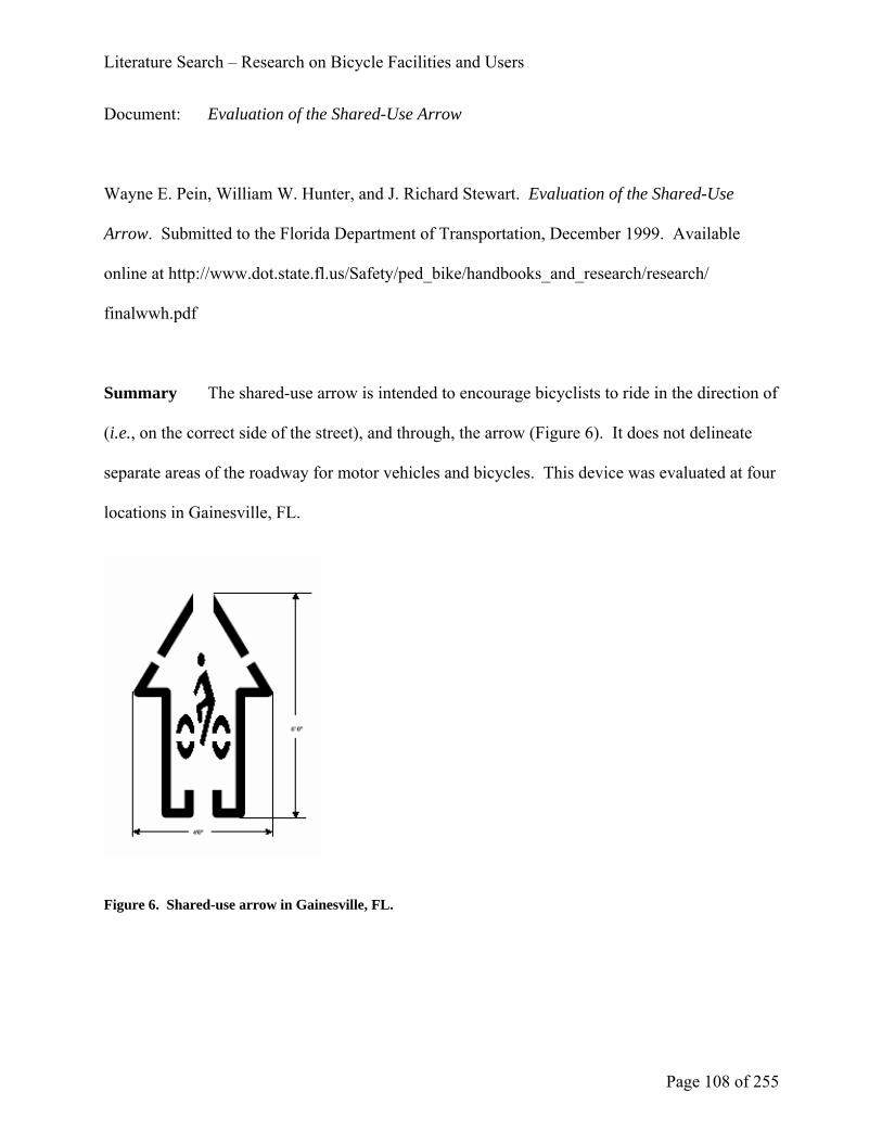
Literature Search – Research on Bicycle Facilities and Users
Page 108 of 255
Document: Evaluation of the Shared-Use Arrow
Wayne E. Pein, William W. Hunter, and J. Richard Stewart. Evaluation of the Shared-Use
Arrow. Submitted to the Florida Department of Transportation, December 1999. Available
online at http://www.dot.state.fl.us/Safety/ped_bike/handbooks_and_research/research/
finalwwh.pdf
Summary The shared-use arrow is intended to encourage bicyclists to ride in the direction of
(i.e., on the correct side of the street), and through, the arrow (Figure 6). It does not delineate
separate areas of the roadway for motor vehicles and bicycles. This device was evaluated at four
locations in Gainesville, FL.
Figure 6. Shared-use arrow in Gainesville, FL.

Literature Search – Research on Bicycle Facilities and Users
Page 109 of 255
The findings are as follows:
Bicyclist position and direction – A higher percentage (45 percent) of bicyclists rode in
the street, with traffic after the arrows were installed than before (39 percent).
Bicycle to curb distance – The arrows resulted in a greater mean bicycle to curb distance
(1.58 feet {0.5 m} before the arrows were installed and 1.83 feet {0.5 m} after).
Bicycle to motor vehicle – There was no statistically significant difference in the lateral
separation between bicycles and motor vehicles, before and after the arrows were
installed.
Motor vehicle to curb distance – There was no statistically significant difference in the
motor vehicle to curb distance, before and after the arrows were installed.
Comments The arrows were installed in a 15-foot {4.6 m} wide curb lane. The arrows are
4.0 feet {1.2 m} across at the widest point and the centerlines of the arrows were 3.5 feet {1.1
m} from the curb. They were placed 80 feet {24.4 m} in advance of an intersection, 20 feet {
6.1 m} after an intersection, and roughly every 200 feet {61 m} between intersections. In the
absence of a striped bike lane, the arrows can provide guidance to bicyclists on where to ride.
However, it is not known how the effectiveness of the arrows compares to that of striped bike
lanes, with respect to the four MOE’s listed above.
Recommendation Based on the results of this study, we do not recommend the inclusion of
shared-use arrows in the AASHTO Bike Guide, unless they are adopted in the MUTCD.

Literature Search – Research on Bicycle Facilities and Users
Page 110 of 255
Document: Evaluation of Bicycle and Pedestrian Facilities: User Satisfaction and
Perceptions on Three Shared Use Trails in Texas.
C. Scott Shafer, Bongkoo Lee, Shawn Turner, and Matt Hughart. Evaluation of Bicycle and
Pedestrian Facilities: User Satisfaction and Perceptions on Three Shared Use Trails in Texas.
Report No. SWUTC/99/472840-00021-1, Texas A&M University, College Station, TX, May
1999.
Abstract (copied from report) This report describes research conducted to evaluate
bicycle and pedestrian facilities (i.e., shared use trails) with user satisfaction and perception
surveys. Public and community input on transportation projects is often mentioned as a
necessary step in the planning process but seldom performed. The opinions and perceptions of
facility users are immensely valuable in improving conditions at current trails as well as in the
development and design of new trails. In this study, the research team developed on-site and
mail-back survey instruments that were distributed on three shared use trails in Texas: the Brays
and Buffalo Bayou Trails in Houston, and the Shoal Creek Trail in Austin. The responses to the
surveys were analyzed to determine consistent themes and trends in user satisfaction and
perceptions. The study found that several trail attributes contribute significantly to user
satisfaction and higher levels of trail use. Adequate separation from motor vehicles was noted as
a positive attribute that should be provided whenever possible on shared use trails. Trail surface
quality and width was also noted as an important attribute, particularly in cases where
numerous user types (e.g., bicyclists, joggers, walkers) were using the same trail. The study also
revealed that many of the trail users felt that the shared use trails significantly contributed to

Literature Search – Research on Bicycle Facilities and Users
Page 111 of 255
harmonizing transportation and community goals. The survey responses indicated that the trails
were used for a variety of purposes, including transportation, recreation, social interaction, and
enjoyment of the natural environment. The researchers concluded that user surveys (such as
those conducted in this study) are a valuable addition to other traditional transportation
planning tools, and as such, can provide more and better insight into roadway and trail user
behavior and motivation.
Comments About 18 percent of the respondents on the Brays Bayou Trail commented that it
was not wide enough. This compared with less than 4 percent on the Buffalo Bayou Trail and
less than 1 percent on the Shoal Creek Trail.
Respondents were asked to indicate the relative importance of 12 trail attributes to their
use of any trail. The top six most important were litter on trail, trail’s separation from traffic,
trail surface maintenance, trail surface type, width of trail, and water fountains. Most of these
are addressed in the AASHTO Bike Guide: litter (p. 73, “Operation and Maintenance”),
separation (p. 33), maintenance (p. 73), surface type (p. 54, “Pavement Structure”), and width
(pp. 35-36).
Recommendation We do not recommend any specific changes to the AASHTO Bike Guide
based on the results of this study.

Literature Search – Research on Bicycle Facilities and Users
Page 112 of 255
Document: Bicycle and Pedestrian Detection: Final Report
SRF Consulting Group, Inc. Bicycle and Pedestrian Detection: Final Report. Prepared for
Federal Highway Administration, February 2003. Available online at
http://projects.dot.state.mn.us/nit/BicyclePedFinalReport/bikePedDetFinalReport.pdf
Summary This report presents the results of a field test of six commercially-available
bicycle and pedestrian detectors (Table 7).
TABLE 7 Detectors and Technologies Tested.
DETECTOR TECHNOLOGY
ASIM DT 272 Passive infrared / ultrasonic
Diamond Traffic Counter Infrared
MS Sedco SmartWalk Microwave
Autoscope Solo Video
3M Microloop Magnetic
Inductive Loop Magnetic
The field test was conducted on the Cedar Lake Trail in Minnesota. This trail has a
pedestrian lane and two bicycle lanes. At the test location, the pedestrian lane is physically
separated from the bicycle lanes. The following activities were performed to measure the level
of detection:
• A ferrous-metal (chrome alloy) bicycle was ridden through the detection zone a total of
100 times
• A non-ferrous (aluminum) bicycle was ridden through the detection zone a total of 100
times

Literature Search – Research on Bicycle Facilities and Users
Page 113 of 255
• One researcher walked through the detection zone a total of 100 times.
All six detectors had an accuracy of 96 percent or higher in detecting the ferrous-metal
bicycle. The 3M Microloop and Diamond Traffic Counter were not included in the non-ferrous
bicycle detection tests; the remaining four detectors had an accuracy of 98 percent or higher. For
pedestrian detection, the 3M Microloop and Inductive Loop were not included; the other four
detectors had an accuracy of 93 percent or higher.
Recommendation We recommend the inclusion of additional detection technologies (besides
loop detectors) in the AASHTO Bike Guide.

Literature Search – Additional References Identified by Survey Respondents
C:\Documents and Settings\rmesler\Desktop\Final Report (2).doc Page 114 of 255
Additional References Identified by Survey Respondents
Concurrently with this literature search, some respondents to the nationwide survey identified
additional references. These are listed below, along with the researchers’ recommendations
whether they should be added to this literature review.
Bicycle Boulevards in Berkeley. Available online at http://www.ci.berkeley.ca.us/transportation/
Bicycling/BB/BicycleBoulevard.html.
We did not add the information on this website to the literature review, as the design
guidelines are limited to specific applications in Berkeley, CA. Also, no operational or
safety studies of these applications are given.
City of Portland. Bicycle Parking Facilities Guidelines. Available online at
http://www.trans.ci.portland.or.us/bicycles/parkguide.htm
We have added these guidelines to the literature review, under “State and Local Design
Guidance.”
Danish Road Directorate. Collection of Cycle Concepts. Available online at
http://www.vejdirektoratet.dk/pdf/cykelrapport/999Complete.pdf
We have added this book to the literature review, under “National Guidance.”

Literature Search – Additional References Identified by Survey Respondents
C:\Documents and Settings\rmesler\Desktop\Final Report (2).doc Page 115 of 255
Illuminating Engineering Society of North America. Recommended Lighting for Walkways and
Class 1 Bikeways.
We have added this design guide to the literature review, under “National Guidance.”
Interface for Cycling Expertise. http://www.i-ce.nl/
From the mission statement:
I-ce is an expertise centre with the aim to support capacity building for planning and
design of cycling facilities in an urban policy context. I-ce delivers expertise to
governments, expert organizations and lobby groups. I-ce facilitates the exchange of
experiences and expertise and makes these applicable in a wide different context.
We did not add the information from this website to the literature review, as it is neither
an evaluation nor design guidance.
Graham Rayman. ‘Dooring’ top culprit in cycling crashes. Newsday. November 19, 2004.
Available online at http://www.transalt.org/press/media/2004/041119newsday.html
We did not add this newspaper article to the literature review. This article is not a safety
study or design guidance. The author interviewed two cyclists who had been doored and
noted that “Transportation advocates estimated yesterday that accidents involving
abruptly opened vehicle doors, known as “dooring,” are the No. 1 cause of bicycle
crashes in the city. It happens about 900 times a year across the city, causing injuries
across the spectrum, according to Transportation Alternatives.” Transportation

Literature Search – Additional References Identified by Survey Respondents
C:\Documents and Settings\rmesler\Desktop\Final Report (2).doc Page 116 of 255
Alternatives (www.transalt.org) is a 5000-member NYC-area non-profit citizens group
working for better bicycling, walking and public transit, and fewer cars.
John Schubert. Pretending to accommodate bicyclists is no solution: Don't sweep known safety
hazards under the rug. Available online at http://www.labreform.org/pretending.html
This article is a position paper rather than original research, so we did not add it to the
literature review.
Sign up for the bike. 3rd edition. November 1996
This manual was published in the Netherlands. We recommend that it be considered for
possible inclusion in the literature review, under “National Guidance.” The 1993 edition
of this manual is referenced in the current AASHTO Bike Guide.
United States Green Building Council. LEED Green Building Rating System. Summary
available online at http://www.usgbc.org/LEED/LEED_Main.asp.
We did not add LEED to the literature review, as it pertains to buildings, not bicycle
facilities.
The LEED (Leadership in Energy and Environmental Design) Green Building Rating
System® is a voluntary, consensus-based national standard for developing high-
performance, sustainable buildings. Members of the U.S. Green Building Council
representing all segments of the building industry developed LEED and continue to
Literature Search – Additional References Identified by Survey Respondents
C:\Documents and Settings\rmesler\Desktop\Final Report (2).doc Page 117 of 255
contribute to its evolution. LEED standards are currently available or under development
for:
• New commercial construction and major renovation projects (LEED-NC)
• Existing building operations (LEED-EB)
• Commercial interiors projects (LEED-CI)
• Core and shell projects (LEED-CS)
• Homes (LEED-H)
• Neighborhood Development (LEED-ND)
Vermont Pedestrian and Bicycle Facility Planning and Design Manual
Available online at
http://www.aot.state.vt.us/progdev/Documents/LTF/FinalPedestrianAndBicycleFacility/Pedestria
nandBicycleFacilityDesignManual.pdf
We have added this manual to the literature review, under “State and Local Design
Guidance.”
W.C. Wilkinson, III, A. Clarke, B. Epperson, and R. Knoblauch. Selecting Roadway Design
Treatments to Accommodate Bicycles. Available online at
http://safety.fhwa.dot.gov/fourthlevel/pdf/Select.pdf (text) and
http://safety.fhwa.dot.gov/fourthlevel/pdf/Tables.pdf (tables)
Although this manual is already referenced in the current AASHTO Bike Guide, we have
added it to the literature review, under “National Guidance.”

Chapter 4: Survey Results
C:\Documents and Settings\rmesler\Desktop\Final Report (2).doc Page 118 of 255
CHAPTER 4: SURVEY RESULTS
The following pages are a reduction of responses to the nationwide internet survey. There
were 468 respondents to the survey. They made a total of 3620 specific comments on the
AASHTO Guide for the Development of Bicycle Facilities and its contents. A printout of the
actual web-based survey questionnaire is at the beginning of Appendix “A.”
There was a wide range of comments made concerning the AASHTO Bike Guide. Many
of the comments made were with respect to specific details of information contained in the
Guide. For instance, many of the comments reflected opinions concerning specific dimensions
given in the Guide. Other comments addressed the format of the Guide. Examples of these
include using a bulleted text format versus a narrative format and numbering the sections. The
researchers believe the comments contained in the survey database and the information gained in
subsequent discussions with respondents will provide valuable information in drafting the actual
text of the next AASHTO Bike Guide.
For each question on the web based survey, each respondent’s answer (or rather,
suggestion) was evaluated in the context of other respondents’ answers to the same question.
Additionally, the researchers looked at the background of each respondent (occupation, job title,
how often and for what he/she uses the AASHTO Bike Guide) to determine additional
perspective on the context (e.g., experience in the planning, design or operation of bicycle
facilities) of the respondent’s recommendations.
The pages that follow are essentially the working notes of the project team as they relate
to the existing AASHTO Bike Guide. In general, they represent the reduced notes of actual topic
areas respondents said the Guide should cover. They are primarily restricted to topics which need

Chapter 4: Survey Results
C:\Documents and Settings\rmesler\Desktop\Final Report (2).doc Page 119 of 255
to be included in next AASHTO Bike Guide, but in some cases may contain specific content
comments.
The final questions on the survey relate to those specific items identified by the
researchers, either from comments of the panel or from their experience teaching the NHI
Bicycle Facilities Design Course. These are contained in the Appendix.

Chapter 4: Survey Results
C:\Documents and Settings\rmesler\Desktop\Final Report (2).doc Page 120 of 255
How often do you use the AASHTO Guide?
How often do you use the AASHTO Guide?
0
20
40
60
80
100
120
140
Every day Once a week Several times permonth
Once a month Rarely Never
Figure 7. How often do you use the AASHTO Guide?
Num
ber o
f Res
pond
ents
Num
ber o
f Res
pond
ents

Chapter 4: Survey Results
C:\Documents and Settings\rmesler\Desktop\Final Report (2).doc Page 121 of 255
For what do you use the Guide?
For what do you use the Guide?
0
50
100
150
200
250
Advocacy Design Planning Review plans
Figure 8. For what do you use the Guide?
Additional Responses
Advise CA Bike Advisory Committee Design check
Education (4) Expert Witness
General information (6)
I helped write KY's Highway Design Manual chapter on Bikes.
I seek all sources of information regarding statistics of bicycle use to promote the further use of
bicycling and to convince government leaders to improve bicycle facilities.
Inform consultants Interpreting engineer-speak
Legal ` Maintenance
Policy Development Preparation of TEP applications
Num
ber o
f Res
pond
ents
Num
ber o
f Res
pond
ents

Chapter 4: Survey Results
C:\Documents and Settings\rmesler\Desktop\Final Report (2).doc Page 122 of 255
Railroad grade crossing safety Reference (3)
Respond to citizen inquiries (4) Review standards/requirements
Safety Studies Teaching / Training (5)
Technical questions Traffic Designer in the 1960's and 1970's
Traffic Policy
Have you ever attended the National Highway Institute (NHI) Bicycle Facilities Design
course?
Yes 62
No 376

Chapter 4: Survey Results
C:\Documents and Settings\rmesler\Desktop\Final Report (2).doc Page 123 of 255
What is your occupation?
What is your occupation?
0
20
40
60
80
100
120
140
Engineer Planner Landscape architect Professor Student Advocate
Figure 9. What is your occupation?
Additional Responses
Alternate Modes Coordinator AmeriCorps Member
Attorney (5) Bicycle / Pedestrian Coordinator (6)
Bicycle Retailer Bicycle tour leader (2)
Bicyclist (2) Catholic Priest
Chemist Clerk
Communications network planner Computer Pgmr/Analyst (2)
Computer Scientist Computer Software Instructor
Consultant (3) Contractor
County Park Dept. staff Cyclist Educator (3)
Num
ber o
f Res
pond
ents
Num
ber o
f Res
pond
ents

Chapter 4: Survey Results
C:\Documents and Settings\rmesler\Desktop\Final Report (2).doc Page 124 of 255
Designer (2) Director of parks and recreation (4)
Economic development Economist
Engineer & PT professor Engineer and Planner (2)
Engineering Technician (2) Enhancement coordinator
Grant administrator (2) Information Technology Architect
Insurance underwriter Judge
Law Enforcement Maytag employee----who loves to ride bike
MD Mechanic
Military Musician
Network software engineer Non profit trail organization administrator
Non-engineer in engineering Orthodontist
Photographer Physician
Planner & Advocate (2) Project Manager
Psychologist Public Relations
Retail Worker (2) Retired (8)
School Bus Driver Software Engineer
State Government Non-motorized policy combines planning and engineering
Stay-at-home mother System administrator
Teacher Technician
Traffic Designer in the 1960's and 1970's Traffic Engineer
Traffic safety analyst (ped & bike) Trail planner in my community
Transit Design

Chapter 4: Survey Results
C:\Documents and Settings\rmesler\Desktop\Final Report (2).doc Page 125 of 255
For what agency/company do you work? or Which best describes your work setting?
For what agency/company do you work? or Which best describes your work setting?
0
20
40
60
80
100
120
140
Federa
l High
way Adm
inistr
ation
State D
epart
ment o
f Tran
sport
ation
MPO
Loca
l tran
sport
ation
plan
ning a
genc
y
Other lo
cal g
overn
ment a
genc
y, ple
ase s
pecif
y
Private
cons
ulting
firm
Univers
ity
Non-pr
ofit o
rganiz
ation
Non-tr
ansp
ortati
on re
lated
orga
nizati
on
Other (
pleas
e spe
cify)
Figure 10. Which best describes your work setting?
Additional Responses
Aerospace Albion Downtown Development Authority
As NGO representative individually and as a member of local government boards
Advisory Committee Member (6) Advocacy Group (3)
Advocate (2) Bicycle retail store (2)
Bicycle tour company Bicycle touring club
Bike advocacy Church
City government (13) Columbus Transportation Division
Computer consulting Conservancy District
Consumer Convenience store
Num
ber o
f Res
pond
ents
Num
ber o
f Res
pond
ents

Chapter 4: Survey Results
C:\Documents and Settings\rmesler\Desktop\Final Report (2).doc Page 126 of 255
County government (10) Design and manufacture
DOD (2) Elected official
ERC, Inc ,NASA contractor Federal Railroad Administration
General contractor General Dynamics
Grocery Industry Hamilton & Terrile, LLP
Health Care Home
Hospital Insurance Company
ISP Law Office
LAB Certified Instructor Menswear retailer
Municipal Government (3) NASA
National Park Service Park district
Private enterprise Private mechanical engineering
Private transportation related Public Works
Regional Planning Agency Retired (8)
Satellite Systems Engineer/League Cycling Instructor/Traffic Engineering Knowledgeable
School District (3) Self employed (5)
Small business owner, bicycle activist. Software - governmental
State and local (DC) State Department of Planning
State Dept of Fish and Game State Dept of Parks and Land
State Dept of Natural Resources (2) State Dept of Environmental Protection
Tiki's Grill and Bar Traffic Safety Department
Transportation Writer US Environmental Protection Agency
USAF Zurich American Insurance Company

Chapter 4: Survey Results
C:\Documents and Settings\rmesler\Desktop\Final Report (2).doc Page 127 of 255
What is your position title? 2nd VP-trail co-coordinator Admin. Asst. III
Administrative Law Judge Administrative Manager (2)
Advocacy Coordinator Advocacy Director
Air Resources Engineer Alternate Modes Coordinator
Architect, Associate Area Engineer
Assistant Director Assistant Director of Transportation
Assistant Engineer Assistant Manager
Assistant Planner Asst. State Ped & Bicycle Coordinator
Assoc Director Associate (2)
Associate Architect Associate Planner (3)
Associate Professor (2) Associate Transportation Analyst
Asst. City Engineer Asst. Dir./Project Manager
Asst. Director of Public Works Asst. Manager
Attorney (2) BFAC representative
Bicycle and Pedestrian Planning Specialist Bicycle Pedestrian Transportation Engineer
Bicycle Program Manager (2) Bicycle Program Manager
Bicycle Transportation Engineer Bicycle, Pedestrian & Greenways Coordinator
Bicycle/Pedestrian Planner
Bicycle/Pedestrian Program Manager Bicycle/Pedestrian Transportation Planner
Bicycle/Pedestrian Transportation Program Manager
Bicycle/Pedestrian/ADA Coordinator Bicycle-Pedestrian Coordinator (23)

Chapter 4: Survey Results
C:\Documents and Settings\rmesler\Desktop\Final Report (2).doc Page 128 of 255
Bikeway Coordinator Bikeways Project Manager
Bikeways Traffic Engineer Board Member (2)
Board of Directors Bus Driver
Cartographer Chair (10)
Chemist Chief Transp Planning Engineer
Chief Engineer Chief of Highway Quality Assurance Division
Chief Road Design Engineer
Chief Strategy Officer Chief Transportation Planner
Chief, Bicycle Facilities Unit Circuit Court Judge
City Engineer / Director of Public Works
City of Austin Bicycle and Pedestrian Program Coordinator
Civil Engineer (3)
Civil Engineer Specialist Civil Engineering Manager
Clerk Clinical Psychologist
Clinical Social worker supervisor Commercial Underwriting Manager
Commission Member Community Cycling Project Director
Community Development Director Computer Scientist
Computer Specialist Consultant (2)
Coordinator Information Management Systems
CTEP Project Engineer (2) CTO
Cyclist Deputy Chief Engineer
Deputy Director, Long Range Planning Deputy Town Clerk
Design Division - Enhancement Engineer Design Engineer

Chapter 4: Survey Results
C:\Documents and Settings\rmesler\Desktop\Final Report (2).doc Page 129 of 255
Design Resource Engineer (CE V) Designer
Director (3) Director Engineering Services
Director of Bicycle and Pedestrian Access Director of Burn Services
Director of Parks & Recreation (2) Director of Planning
Director of Transportation and Data Services
Director, Tech Support District 1 Local Systems Engineer
District Enhancement Coordinator (also Bike/Ped. Coordinator)
District Planner (2) District Roadway Design Engineer
District Safety Engineer District Traffic Engineer
Division Chief, Highway Design Education Director
Embedded Software Engineer Engineer (3)
Engineer 5 Dual Career Ladder (DCL) Engineer of Roadway Design
Engineer Technician II Engineering Manager
Engineering Technician Enhancement Engineer
Engineering Tech II Enterprise Systems Architect
Environmental Programs Coordinator Environmental Specialist
Envr. Coord./ROW/Homeland Security Executive Director (16)
Field Representative (2) Field Representative
Founding Member General Manager
Geometrics Engineer Government Relations Director
Government to Government Section Supervisor
Grants Coordinator Highway Design Engineer
Insurance broker Industrial Designer

Chapter 4: Survey Results
C:\Documents and Settings\rmesler\Desktop\Final Report (2).doc Page 130 of 255
Instructor King
Landscape Architect (5) Library Asst.
Local Agency Project Manager Local Project Liaison
LPA Coordinator Manager
Manager - Traffic Engineering Manager - Transportation Planning
Manager of Planning & Development
Manager of the River Corridor Improvement Subdistrict
Manager Transportation Enhancement and Scenic Roads
Manager, Grants and Community Recreation
Managing Attorney Managing Director
Managing Engineer Mechanical Engineer
Membership development MPO Director
Municipal Engineer Senior n/a (5)
Network Engineer Newspaper Reporter
Non-Motorized Transportation Coordinator (2)
Off-Systems Engineer Operations Coordinator
Orthodontist Outdoor Recreation Planner
Owner (4) P.E.1
Park Project Coordinator Parks & Recreation Acting Director
Part-time Faculty Partner
Pastor Pastoral Representative
Pathways Project Manager Pedestrian & Bicycle Program Manager
Pedestrian and Bicycle Engineer Photographer

Chapter 4: Survey Results
C:\Documents and Settings\rmesler\Desktop\Final Report (2).doc Page 131 of 255
Physical Planner Planner (6)
Planner/Analyst Planning Coordinator
Planning Director Planning Manager
President (9) Principal (3)
Principal Engineer (2) Principal Planner (2)
Product Planning Engineer Professor (3)
Program Manager Project Engineer (5)
Project Manager (8) Bike Ped Coordinator
Project Planner (2) Public Information Officer
Public Works Engineering Specialist Public Works Planner
Purchaser Recreation Planner
Regional Landscape Architect Regional Traffic Design Manager
Research Associate Resident Engineer (2)
Retired (2) Roadway Design Division Engineer
Roadway Design Engineer Rural/Enhancement Development Engr.
Safety Officer Safety Technician
Sales Advisor Scientific Research Assistant
Scientific/Technical (4) Senior Civil Engineer
Senior Civil Engineers Supervisor Senior Engineer (3)
Senior Environmental Planner Senior Highway Designer
Senior Highway Design Technician Senior Industry Economist
Senior Planner (6) Senior Project Engineer
Senior Project Manager (3) Senior Structural Engineer

Chapter 4: Survey Results
C:\Documents and Settings\rmesler\Desktop\Final Report (2).doc Page 132 of 255
Senior Transportation Engineer Senior Transportation Planner (7)
Site-based Pediatric Services Engineer Software Engineer
Software Engineer Special Projects Engineer/Area Design Facilitator
Sr Applications Development Specialist
Sr Software Engineer Sr. Engineering Associate
Sr. Mech. Design Engr Sr. Project Manager
Staff Design Engineer Staff Engineer
Standards Engineer State Bicycle and Pedestrian Coordinator (5)
State Program Administrator State Traffic Engineer
Systems Planning Branch Manager Teacher (2)
Team Leader, Statewide Studies Team Technical Sergeant
Technical Support Engineer Tour Leader
Traffic Control Specialist Traffic Engineer III
Traffic Engineer/Bicycle Coordinator Traffic Engineering Administrator
Traffic Operations Engineer Traffic Policy Engineer
Traffic Safety Program Manager Traffic Studies Engineer
Trail Maintenance Manager Trail Program Specialist
Trails Coordinator (3) Transit Program Manager
Transportation Alternatives Planner Transportation Engineer Branch Manager
Transportation Planner (14) Transportation Planning Coordinator
Transportation Planning Coordinator Transportation Program Manager
Transportation Project Manager University Police Officer
Vice president (3) Vice-Chair

Chapter 4: Survey Results
C:\Documents and Settings\rmesler\Desktop\Final Report (2).doc Page 133 of 255
Visiting Scientist Volunteer
Was Traffic Design and Standards Engineer
Writer
Of which organizations are you a member?
Of which organizations are you a member?
0
50
100
150
200
250
AASHTO Com
mittee
ITEASCE
AIAAPW
AASLA
APBPAPA
LAB
RTC
Bike ad
voca
cy or
ganiz
ation
Figure 11. Of which organizations are you a member?
Num
ber o
f Res
pond
ents
Num
ber o
f Res
pond
ents

Chapter 4: Survey Results
C:\Documents and Settings\rmesler\Desktop\Final Report (2).doc Page 134 of 255
OPERATING SPACE REQUIRED FOR A BICYCLE
(pg. 5 - 'The Bicycle' and Figure 1) How well does the Bike Guide address this subject area?
OPERATING SPACE REQUIRED FOR A BICYCLE (pg. 5 - 'The Bicycle' and Figure 1) How well does the Bike Guide address this subject area?
0
20
40
60
80
100
120
140
160
Adequately addressed Needs to be more thoroughlyaddressed or revised
No opinion Not appropriate for the Bike Guide
Figure 12. Operating Space Required for a Bicycle – How well does the Bike Guide address this subject
area?
Not appropriate for the Bike Guide, please identify what document should address this
subject?
Unknown
Needs to be more thoroughly addressed or revised -
Greater discussion of side clearance or shy distance
Discussion of various user types
Discussion of two way operations
Discuss how widths are linked to design standards
Num
ber o
f Res
pond
ents
Num
ber o
f Res
pond
ents

Chapter 4: Survey Results
C:\Documents and Settings\rmesler\Desktop\Final Report (2).doc Page 135 of 255
areas with numerous driveways
how traffic volume and speed can increase the needed width
how pavement condition can increase needed width
Discuss how user type impacts needed width
Description of bicycles should be separated from discussion of bicycle users
Update the dimensions using data from the most current research

Chapter 4: Survey Results
C:\Documents and Settings\rmesler\Desktop\Final Report (2).doc Page 136 of 255
THE BICYCLE USER
(pg. 5) How well does the Bike Guide address this subject area?
THE BICYCLE USER (pg. 5) How well does the Bike Guide address this subject area?
0
20
40
60
80
100
120
140
160
180
Adequately addressed Needs to be more thoroughlyaddressed or revised
No opinion Not appropriate for the Bike Guide
Figure 13. The Bicycle User – How well does the Bike Guide address this subject area?
Not appropriate for the Bike Guide, please identify what document should address this
subject?
Unknown
Needs to be more thoroughly addressed or revised -
There is considerable concern that the A/B/C classification of cyclists is not sufficient to describe
all cyclists. A more detailed discussion of the various bicycle users and their levels of
experience, ability, and knowledge is suggested.
Num
ber o
f Res
pond
ents
Num
ber o
f Res
pond
ents

Chapter 4: Survey Results
C:\Documents and Settings\rmesler\Desktop\Final Report (2).doc Page 137 of 255
SELECTION OF A BICYCLE FACILITY OR CHOOSING THE APPROPRIATE
FACILITY TYPE
(pg. 6) How well does the Bike Guide address this subject area?
SELECTION OF A BICYCLE FACILITY OR CHOOSING THE APPROPRIATE FACILITY TYPE (pg. 6) How well does the Bike Guide address this subject area?
0
20
40
60
80
100
120
140
Adequately addressed Needs to be more thoroughlyaddressed or revised
No opinion Not appropriate for the Bike Guide
Figure 14. Selection of a Bicycle Facility or Choosing the Appropriate Facility Type – How well does the Bike
Guide address this subject area?
Not appropriate for the Bike Guide, please identify what document should address
this subject?
Not necessary
An advocacy document
Unknown
Num
ber o
f Res
pond
ents
Num
ber o
f Res
pond
ents

Chapter 4: Survey Results
C:\Documents and Settings\rmesler\Desktop\Final Report (2).doc Page 138 of 255
Needs to be more thoroughly addressed or revised -
There were a significant number of comments suggesting that no choice is necessary as all
roadways are bicycle facilities and bike lanes detract from the safety of the shared travel lanes.
Several comments were made recommending a matrix or table to determine under what roadway
conditions a particular facility would be appropriate (such as that FHWA's Design Treatments
for Bicycle Facilities)
The mix of facility users (skaters, pedestrians, equestrians) was recommended as a criterion for
selecting a facility
Discuss choosing a facility is by functional class of the roadway
Discuss which facilities accommodate cyclists in given roadway environments
Recognize that all roadways are bicycle facilities
Reference FHWA’s Guidance that bicycle facilities should be included on all roadways where
bicyclists are not prohibited
Provide a greater emphasis on continuity
Combine with selection of a bicycle facility
Provide discussion that choosing the appropriate facility type also depends on existing terrain,
right-of-way, local municipal ordinances, etc.

Chapter 4: Survey Results
C:\Documents and Settings\rmesler\Desktop\Final Report (2).doc Page 139 of 255
TYPES OF BICYCLE FACILITIES
(pg. 7) How well does the Bike Guide address this subject area?
TYPES OF BICYCLE FACILITIES (pg. 7) How well does the Bike Guide address this subject area?
0
20
40
60
80
100
120
140
160
Adequately addressed Needs to be more thoroughlyaddressed or revised
No opinion Not appropriate for the Bike Guide
Figure 15. Types of Bicycle Facilities – How well does the Bike Guide address this subject area?
Not appropriate for the Bike Guide, please identify what document should address this
subject?
Unknown
Needs to be more thoroughly addressed or revised -
There were a significant number of comments suggesting that the best and safest bicycle facility
is the shared roadway, some included the wide curb lane in this category. These respondents felt
that no other facility needs to be included in the Guide. Some felt that this guide should stress
that the best system is a shared lane system with well educated bicyclists.
Num
ber o
f Res
pond
ents
Num
ber o
f Res
pond
ents

Chapter 4: Survey Results
C:\Documents and Settings\rmesler\Desktop\Final Report (2).doc Page 140 of 255
Others suggested that any residential roads should be eligible to be signed as bicycle facilities as
these roadways are where most children ride.
Remove the statement that some roadways may be unsuitable for bicycle travel
Point out in the introduction that all roadways, except those where bicyclists are prohibited, are
bicycle facilities and should therefore be made as bicycle friendly as possible
Recognize that many roadways and rural highways, even with narrow lanes and no shoulders,
can be entirely suitable for bicycle travel when there is low ADT
Include example pictures of each type of facility
There are states in which riding on a paved shoulder is prohibited by law (Missouri for instance)
Discuss the shared lane using the shared lane arrow
Others request shoulders be included as separate type of bicycle facility
Discuss the impact of rumble strips on the usability of paved shoulders
Include wide curb lanes as a separate facility type
Clarification should be made that designated bikeways may pertain to a master plan or map only
– that they do not necessarily require signing in the roadway environment
Discuss bicycle boulevards
Refer to the cautions concerning shared use paths adjacent to roadways
Discuss multimodal facilities

Chapter 4: Survey Results
C:\Documents and Settings\rmesler\Desktop\Final Report (2).doc Page 141 of 255
INVENTORY OF EXISTING CONDITIONS
(pg. 9) How well does the Bike Guide address this subject area?
INVENTORY OF EXISTING CONDITIONS (pg. 9) How well does the Bike Guide address this subject area?
0
20
40
60
80
100
120
140
160
Adequately addressed Needs to be more thoroughlyaddressed or revised
No opinion Not appropriate for the Bike Guide
Figure 16. Inventory of Existing Conditions – How well does the Bike Guide address this subject area?
Not appropriate for the Bike Guide, please identify what document should address this
subject?
Unknown
Needs to be more thoroughly addressed or revised -
Discuss how an inventory would be used as part of an overall planning process
Discuss the use of GIS to inventory
Discuss the need to update existing GIS systems and models to consider bicycle facilities
Discuss not only existing conditions but latent demand as well
Num
ber o
f Res
pond
ents
Num
ber o
f Res
pond
ents

Chapter 4: Survey Results
C:\Documents and Settings\rmesler\Desktop\Final Report (2).doc Page 142 of 255
Integrate this section with facilities types and plans for improvements
Include a discussion of BCI and/or BLOS
Discuss the need for an entire network
Discuss the drawbacks of bicycle volume counts
Should include a survey of bicycle crash reports to identify areas where actual hazards exist
Provide a list of what items should be inventoried
Discuss travel demand studies and mode shift potential
Discuss the need for bicycle access and circulation in development planning
Include tools for a bikeability audit
Include a recommendation to survey actual bicyclists in the area
Discuss the importance of adjacent land use
Discuss identification of origins and destinations

Chapter 4: Survey Results
C:\Documents and Settings\rmesler\Desktop\Final Report (2).doc Page 143 of 255
PLANS FOR IMPROVEMENTS
(pg. 10) How well does the Bike Guide address this subject area?
PLANS FOR IMPROVEMENTS (pg. 10) How well does the Bike Guide address this subject area?
0
20
40
60
80
100
120
140
Adequately addressed Needs to be more thoroughlyaddressed or revised
No opinion Not appropriate for the Bike Guide
Figure 17. Plans for Improvements – How well does the Bike Guide address this subject area?
Not appropriate for the Bike Guide, please identify what document should address this
subject?
Unknown
Needs to be more thoroughly addressed or revised -
Integrate with facility type and existing conditions
Include discussion of a route network
Provide example plan for improvement (website or appendix)
Discuss methods for prioritization
Num
ber o
f Res
pond
ents
Num
ber o
f Res
pond
ents

Chapter 4: Survey Results
C:\Documents and Settings\rmesler\Desktop\Final Report (2).doc Page 144 of 255
Discuss the merits of integrating pedestrian with bicycle planning
Provide recommendations for conducting preliminary feasibility analysis of top ranked proposals
to ensure they can be constructed.
Discuss the consideration of environmental and community factors
Discuss bicycle improvements (paved shoulders) as part of routine accommodation
Discuss funding options
Discuss the need for bicycle friendly policies
Discuss the potential for restriping existing roadways to include bike lanes
Include a formula for predicting usage
Discuss a bicycle facility / route hierarchy
Discuss multimodal planning
Discuss specific project planning in addition to network planning
Discuss access management
Discuss mainstreaming bicycle planning into regular planning efforts
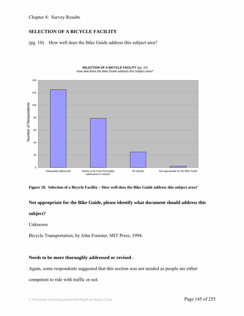
Chapter 4: Survey Results
C:\Documents and Settings\rmesler\Desktop\Final Report (2).doc Page 145 of 255
SELECTION OF A BICYCLE FACILITY
(pg. 10) How well does the Bike Guide address this subject area?
SELECTION OF A BICYCLE FACILITY (pg. 10) How well does the Bike Guide address this subject area?
0
20
40
60
80
100
120
140
Adequately addressed Needs to be more thoroughlyaddressed or revised
No opinion Not appropriate for the Bike Guide
Figure 18. Selection of a Bicycle Facility – How well does the Bike Guide address this subject area?
Not appropriate for the Bike Guide, please identify what document should address this
subject?
Unknown
Bicycle Transportation, by John Forester, MIT Press, 1994.
Needs to be more thoroughly addressed or revised -
Again, some respondents suggested that this section was not needed as people are either
competent to ride with traffic or not.
Num
ber o
f Res
pond
ents
Num
ber o
f Res
pond
ents

Chapter 4: Survey Results
C:\Documents and Settings\rmesler\Desktop\Final Report (2).doc Page 146 of 255
Numerous respondents suggested that back in angle parking be recognized as preferable to
traditional angle parking
Discuss the “why” of selecting a particular bicycle facility
Include traffic calming as a consideration
Include accessibility of destinations and amenities as considerations
Include community priorities as a consideration
Include connectivity, including access to transit, as a consideration
Include roadway lighting as a consideration
Include BLOS / BCI as a consideration
Include risk of derailment of adjacent rail lines
Include steep grades as a consideration
One respondent stated, “I think this section is a somewhat rudderless long list of things to muse
about.”
Classify the factors with respect to their relevance for particular situations
Include a flow chart to illustrate how to apply these factors
Include in the section on SELECTION OF A BICYCLE FACILITY or CHOOSING THE
APPROPRIATE FACILITY TYPE
This section should precede PLANS FOR IMPROVEMENTS and somehow be merged with
INVENTORY OF EXISTING CONDITIONS
Include tables from FHWA's Design Treatments for Bicycle Facilities
Another respondent counters with “This document just doesn't have the research or operational
justification to be cited as an authoritative reference by AASHTO.”
Mention effects of wind blast due to trucks and buses

Chapter 4: Survey Results
C:\Documents and Settings\rmesler\Desktop\Final Report (2).doc Page 147 of 255
Mention extremely low friction coefficient of metal bridge decking when wet
Discuss the potential for using multiple facility types to serve multiple user types

Chapter 4: Survey Results
C:\Documents and Settings\rmesler\Desktop\Final Report (2).doc Page 148 of 255
EDUCATION PROGRAMS FOR BICYCLISTS AND MOTORISTS
(pg. 13) How well does the Bike Guide address this subject area?
EDUCATION PROGRAMS FOR BICYCLISTS AND MOTORISTS(pg. 13)How well does the Bike Guide address this subject area?
0
20
40
60
80
100
120
Adequately addressed Needs to be more thoroughlyaddressed or revised
No opinion Not appropriate for the Bike Guide
Figure 19. Education Programs for Bicyclists and Motorists – How well does the Bike Guide address this
subject area?
Not appropriate for the Bike Guide, please identify what document should address this
subject?
Not a design guide issue (4)
Effective Cycling
NHTSA
Bicycle Plans
Specific Safety Curriculum
Drivers Education
Num
ber o
f Res
pond
ents
Num
ber o
f Res
pond
ents

Chapter 4: Survey Results
C:\Documents and Settings\rmesler\Desktop\Final Report (2).doc Page 149 of 255
Safety Education in Schools
Education Programs for Bicyclists and Motorists
Unknown (3)
Needs to be more thoroughly addressed or revised -
Identify funding sources
Include the rules of the road for bicyclists
Include the importance of using lights and a rear reflector at night
Incorporate LAB Road 1 information
Discuss the proper use of mirrors
Create a separate chapter for education
Remove this section except to reference a more comprehensive work
Discuss the coordination of educational efforts
Discuss developmental factors that impact children’s abilities
Add details on crash causes
Place motorist education first to emphasize its importance
Discuss the need to educate law enforcement
Discuss the need to educate engineers
Discuss the need to educate children’s parents
Bicycles are not vehicles in all states
Add a section on Safe Routes to School
Discuss different types of educational programs

Chapter 4: Survey Results
C:\Documents and Settings\rmesler\Desktop\Final Report (2).doc Page 150 of 255
Please indicate any other topics related to Bicycle Facilities Planning that should be
addressed in the next Bike Guide update
Discuss strategic bicycle network planning including land development regulations and
integration with other plans
Discuss the impact of local laws on the selection of and design of bicycle facilities
Include a definition for sidepaths and sidewalks
Promote mainstreaming of shared use facilities
Provide a checklist of bicycle consideration to be included on non-bicycle specific transportation
projects
Discuss the liability of providing bicycle facilities
Discuss facility costs
Discuss how the requirements of the ADA impact the planning and design of bicycle facilities
Provide links to good bike plans
Discuss the safety and economic benefits of bicycle facilities
Discuss traffic calming and streetscaping
Discussion of bicycle crash types and causes
Consider the needs of all non-motorized modes in the planning section
Discuss including shared use path facilities as part of a functional classification for roadways
system

Chapter 4: Survey Results
C:\Documents and Settings\rmesler\Desktop\Final Report (2).doc Page 151 of 255
SHARED ROADWAYS
(pg. 16) How well does the Bike Guide address this subject area?
SHARED ROADWAYS (pg. 16)How well does the Bike Guide address this subject area?
0
20
40
60
80
100
120
140
160
Adequately addressed Needs to be more thoroughlyaddressed or revised
No opinion Not appropriate for the Bike Guide
Figure 20. Shared Roadways – How well does the Bike Guide address this subject area?
Not appropriate for the Bike Guide, please identify what document should address this
subject?
Unknown
Needs to be more thoroughly addressed or revised -
Discuss the use of the shared lane arrow
Discuss maintenance issues being less of a concern in shared lanes
Discuss the potential of reducing general travel lane widths to provide space for bike lanes
Discuss the impact of speed on the appropriateness of shared roadways
Num
ber o
f Res
pond
ents
Num
ber o
f Res
pond
ents

Chapter 4: Survey Results
C:\Documents and Settings\rmesler\Desktop\Final Report (2).doc Page 152 of 255
Discuss the impact of speed on the appropriateness of shared roadways
Discuss the impact of volume on the appropriateness of shared roadways
Discuss the impact of on-street parking on shared roadway facilities
Discuss maximum cross slope

Chapter 4: Survey Results
C:\Documents and Settings\rmesler\Desktop\Final Report (2).doc Page 153 of 255
PAVED SHOULDERS
(pg. 16) How well does the Bike Guide address this subject area?
PAVED SHOULDERS (pg. 16) How well does the Bike Guide address this subject area?
0
20
40
60
80
100
120
140
Adequately addressed Needs to be more thoroughlyaddressed or revised
No opinion Not appropriate for the Bike Guide
Figure 21. Paved Shoulders – How well does the Bike Guide address this subject area?
Not appropriate for the Bike Guide, please identify what document should address this
subject?
Unknown
N/A
Needs to be more thoroughly addressed or revised -
Discuss the impact of rumble strips on the effective width of paved shoulders
Delete the statement that any shoulder width is better than none at all
Discuss the impacts of maintenance on the usefulness of paved shoulders
Num
ber o
f Res
pond
ents
Num
ber o
f Res
pond
ents

Chapter 4: Survey Results
C:\Documents and Settings\rmesler\Desktop\Final Report (2).doc Page 154 of 255
Discuss that riding a bicycle on a paved shoulder is illegal in some states
Clarify that paved shoulders are not bike lanes in that shoulders are placed to the right of right
turn lanes. This means the cyclists must leave the shoulder to be in the proper position to travel
straight through an intersection with a right turn lane.
Discuss desirable shoulder width as a function of volume, speed, truck volumes
Discuss the use of paved shoulders on curb and gutter sections

Chapter 4: Survey Results
C:\Documents and Settings\rmesler\Desktop\Final Report (2).doc Page 155 of 255
INCREASED LANE WIDTH
(pg. 17) How well does the Bike Guide address this subject area?
INCREASED LANE WIDTH (pg. 17) How well does the Bike Guide address this subject area?
0
20
40
60
80
100
120
140
160
Adequately addressed Needs to be more thoroughlyaddressed or revised
No opinion Not appropriate for the Bike Guide
Figure 22. Increased Lane Width – How well does the Bike Guide address this subject area?
Not appropriate for the Bike Guide, please identify what document should address this
subject?
Unknown
Needs to be more thoroughly addressed or revised -
Discuss the importance of width of various types of roadways
Discuss the potential need to prohibit parking form roadways with wide lanes
Discuss the appropriate lane width for various combinations of roadway speeds, volumes, truck
percentages
Num
ber o
f Res
pond
ents
Num
ber o
f Res
pond
ents

Chapter 4: Survey Results
C:\Documents and Settings\rmesler\Desktop\Final Report (2).doc Page 156 of 255
Discuss the impact of wide curb lanes on motor vehicle speeds
Expand the discussion on the potential for restriping roadways for bike lanes instead of using
wide outside lanes
Discuss how minimum safe passing distance between motorists and bicyclists, bicyclists
operating width requirements and motor vehicle width requirements add up to require a
minimum wide curb lane width

Chapter 4: Survey Results
C:\Documents and Settings\rmesler\Desktop\Final Report (2).doc Page 157 of 255
BIKE FACILITIES WITH ON-STREET PARKING
(pg. 17) How well does the Bike Guide address this subject area?
BIKE FACILITIES WITH ON-STREET PARKING (pg. 17)
How well does the Bike Guide address this subject area?
0
20
40
60
80
100
120
Adequately addressed Needs to be more thoroughlyaddressed or revised
No opinion Not appropriate for the Bike Guide
Figure 23. Bike Facilities with On-street Parking – How well does the Bike Guide address this subject area?
Not appropriate for the Bike Guide, please identify what document should address this
subject?
Unknown
Needs to be more thoroughly addressed or revised -
Most of the respondents comments were concerned with the issue of the door zone and dooring
crashes. Many opinions and mathematical constructs were suggested for dealing with this issue
Discuss back-in angle parking
Discuss time-of-day on-street parking
Num
ber o
f Res
pond
ents
Num
ber o
f Res
pond
ents

Chapter 4: Survey Results
C:\Documents and Settings\rmesler\Desktop\Final Report (2).doc Page 158 of 255
PAVEMENT SURFACE QUALITY
(pg. 18) How well does the Bike Guide address this subject area?
PAVEMENT SURFACE QUALITY (pg. 18) How well does the Bike Guide address this subject area?
0
20
40
60
80
100
120
140
Adequately addressed Needs to be more thoroughlyaddressed or revised
No opinion Not appropriate for the Bike Guide
Figure 24. Pavement Surface Quality – How well does the Bike Guide address this subject area?
Not appropriate for the Bike Guide, please identify what document should address this
subject?
Unknown
Needs to be more thoroughly addressed or revised -
Quantify acceptable joint widths, drop offs, etc.
Discuss unacceptable surface treatments (chip-seal)
Discuss the potential problems with some traffic calming surfaces
Discuss longitudinal versus transverse cracks
Num
ber o
f Res
pond
ents
Num
ber o
f Res
pond
ents

Chapter 4: Survey Results
C:\Documents and Settings\rmesler\Desktop\Final Report (2).doc Page 159 of 255
Discuss problems with thermoplastic markings
DRAINAGE INLET GRATES
(pg. 18) How well does the Bike Guide address this subject area?
PAVEMENT SURFACE QUALITY (pg. 18) How well does the Bike Guide address this subject area?
0
20
40
60
80
100
120
140
160
Needs to be more thoroughlyaddressed or revised
No opinion Not appropriate for the Bike Guide
Figure 25. Drainage Inlet Grates – How well does the Bike Guide address this subject area?
Not appropriate for the Bike Guide, please identify what document should address this
subject?
Unknown
Needs to be more thoroughly addressed or revised -
Discuss curb inlet designs
Discuss the drop-in type crash
Num
ber o
f Res
pond
ents
Num
ber o
f Res
pond
ents

Chapter 4: Survey Results
C:\Documents and Settings\rmesler\Desktop\Final Report (2).doc Page 160 of 255
SIGNED SHARED ROADWAYS
(pg. 19) How well does the Bike Guide address this subject area?
SIGNED SHARED ROADWAYS (pg. 19)How well does the Bike Guide address this subject area?
0
20
40
60
80
100
120
140
Adequately addressed Needs to be more thoroughlyaddressed or revised
No opinion Not appropriate for the Bike Guide
Figure 26. Signed Shared Roadways – How well does the Bike Guide address this subject area?
Not appropriate for the Bike Guide, please identify what document should address this
subject?
MUTCD
Needs to be more thoroughly addressed or revised -
Rename this section Designated Bicycle Routes
Expand the discussion of distance, direction, and destination signing
Add a section on the Share the Road sign
Num
ber o
f Res
pond
ents
Num
ber o
f Res
pond
ents

Chapter 4: Survey Results
C:\Documents and Settings\rmesler\Desktop\Final Report (2).doc Page 161 of 255
Make this section an introduction and move the Bike Rout info to the SIGNING OF SHARED
ROADWAYS SECTION

Chapter 4: Survey Results
C:\Documents and Settings\rmesler\Desktop\Final Report (2).doc Page 162 of 255
DESIGNATING SIDEWALKS AS SIGNED BIKEWAYS
(pg. 20) How well does the Bike Guide address this subject area?
DESIGNATING SIDEWALKS AS SIGNED BIKEWAYS (pg. 20) How well does the Bike Guide address this subject area?
0
20
40
60
80
100
120
140
Adequately addressed Needs to be more thoroughlyaddressed or revised
No opinion Not appropriate for the Bike Guide
Figure 27. Designating Sidewalks as Signed Bikeways – How well does the Bike Guide address this subject
area?
Not appropriate for the Bike Guide, please identify what document should address this
subject?
MUTCD
I don't agree with the use of sidewalks for bikes
Needs to be more thoroughly addressed or revised -
Most of the comments in this section suggested increasing the emphasis on discouraging
sidewalk bicycle facilities
Num
ber o
f Res
pond
ents
Num
ber o
f Res
pond
ents

Chapter 4: Survey Results
C:\Documents and Settings\rmesler\Desktop\Final Report (2).doc Page 163 of 255
Provide crash statistics
Change this heading to SIDEWALKS SHOULD NOT BE DESIGNATED AS BIKEWAYS
Discuss access management
Discuss why sidewalks are not bicycle facilities (design criteria)
Discuss who might be comfortable using sidewalks as bicycle facilities
Discuss the legal issues with bicyclist use of crosswalks, with some states' laws interpreted to
mean that bicycle riding in crosswalks is illegal or negligent
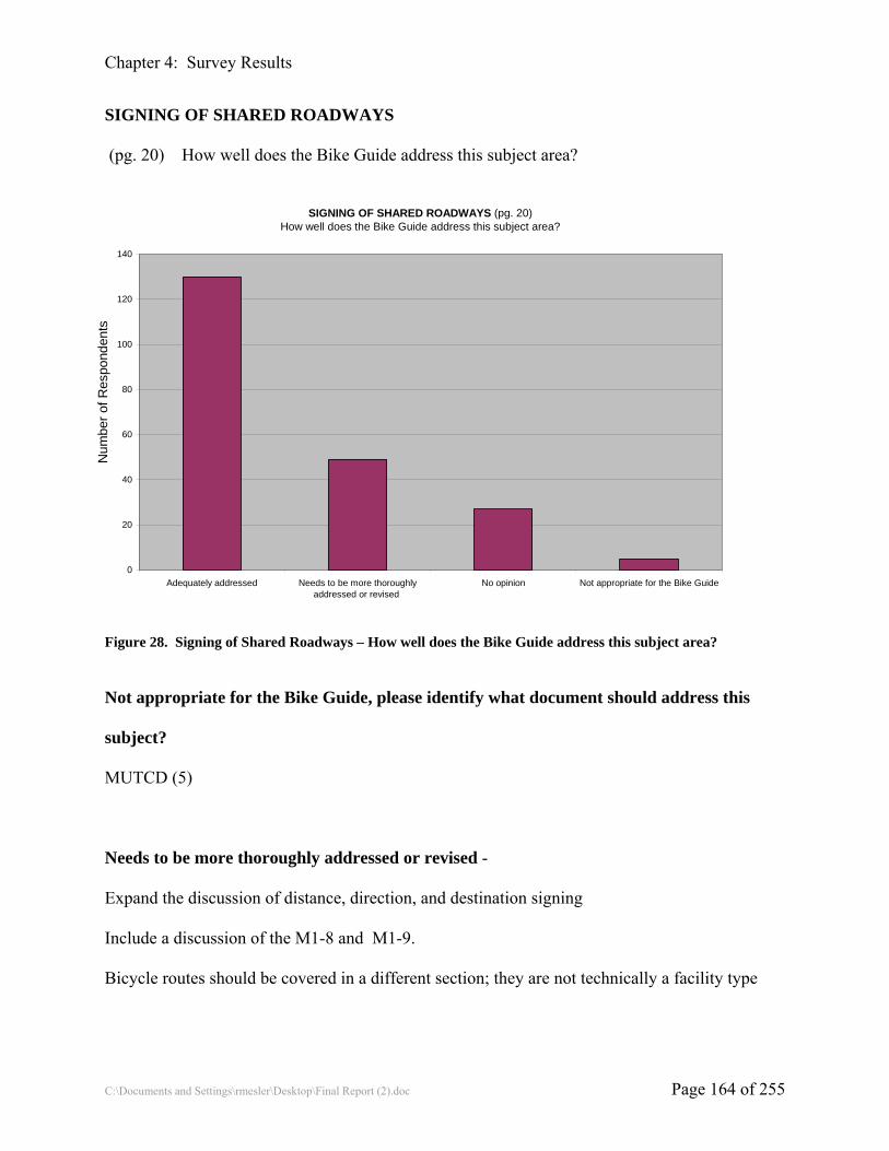
Chapter 4: Survey Results
C:\Documents and Settings\rmesler\Desktop\Final Report (2).doc Page 164 of 255
SIGNING OF SHARED ROADWAYS
(pg. 20) How well does the Bike Guide address this subject area?
SIGNING OF SHARED ROADWAYS (pg. 20) How well does the Bike Guide address this subject area?
0
20
40
60
80
100
120
140
Adequately addressed Needs to be more thoroughlyaddressed or revised
No opinion Not appropriate for the Bike Guide
Figure 28. Signing of Shared Roadways – How well does the Bike Guide address this subject area?
Not appropriate for the Bike Guide, please identify what document should address this
subject?
MUTCD (5)
Needs to be more thoroughly addressed or revised -
Expand the discussion of distance, direction, and destination signing
Include a discussion of the M1-8 and M1-9.
Bicycle routes should be covered in a different section; they are not technically a facility type
Num
ber o
f Res
pond
ents
Num
ber o
f Res
pond
ents

Chapter 4: Survey Results
C:\Documents and Settings\rmesler\Desktop\Final Report (2).doc Page 165 of 255
BIKE LANES
(pg. 22) How well does the Bike Guide address this subject area?
BIKE LANES (pg. 22)How well does the Bike Guide address this subject area?
0
20
40
60
80
100
120
140
160
Adequately addressed Needs to be more thoroughlyaddressed or revised
No opinion Not appropriate for the Bike Guide
Figure 29. Bike Lanes – How well does the Bike Guide address this subject area?
Not appropriate for the Bike Guide, please identify what document should address this
subject?
Needs to be more thoroughly addressed or revised -
A large number of respondents stated that bike lanes decreased the safety of the roadway for
bicyclists and led to improper cycling behavior.
Discuss how the mandatory sidepath law affects the desirability of providing bike lanes.
Num
ber o
f Res
pond
ents
Num
ber o
f Res
pond
ents

Chapter 4: Survey Results
C:\Documents and Settings\rmesler\Desktop\Final Report (2).doc Page 166 of 255
BIKE LANE WIDTHS
(pg. 22) How well does the Bike Guide address this subject area?
BIKE LANE WIDTHS (pg. 22)How well does the Bike Guide address this subject area?
0
20
40
60
80
100
120
140
Adequately addressed Needs to be more thoroughlyaddressed or revised
No opinion Not appropriate for the Bike Guide
Figure 30. Bike Lane Widths – How well does the Bike Guide address this subject area?
Not appropriate for the Bike Guide, please identify what document should address this
subject?
Nowhere
Needs to be more thoroughly addressed or revised -
Many of the respondents’ comments were concerned with the door zone next to on-street parking
Discuss the use of contrasting pavement in bike lanes
Discuss the impact of traffic volumes, speeds, and percent trucks on the desirable bike lane width
Discuss clearance to roadside hazards
Num
ber o
f Res
pond
ents
Num
ber o
f Res
pond
ents

Chapter 4: Survey Results
C:\Documents and Settings\rmesler\Desktop\Final Report (2).doc Page 167 of 255
Discuss the width requirements of non traditional users – in-line skaters, tricyclists

Chapter 4: Survey Results
C:\Documents and Settings\rmesler\Desktop\Final Report (2).doc Page 168 of 255
BIKE LANES AT INTERSECTIONS
(pg. 25) How well does the Bike Guide address this subject area?
BIKE LANES AT INTERSECTONS (pg. 25)How well does the Bike Guide address this subject area?
0
20
40
60
80
100
120
140
Adequately addressed Needs to be more thoroughlyaddressed or revised
No opinion Not appropriate for the Bike Guide
Figure 31. Bike Lanes at Intersections – How well does the Bike Guide address this subject area?
Not appropriate for the Bike Guide, please identify what document should address this
subject?
Needs to be more thoroughly addressed or revised -
Introduce and define bike boxes and bike slots
Discuss how bicyclists are supposed to navigate though intersections with respect to their
movements – right turns, left turns, through movements
Num
ber o
f Res
pond
ents
Num
ber o
f Res
pond
ents

Chapter 4: Survey Results
C:\Documents and Settings\rmesler\Desktop\Final Report (2).doc Page 169 of 255
BIKE LANES AND TURNING LANES
(pg. 25) How well does the Bike Guide address this subject area?
BIKE LANES AND TURNING LANES (pg. 25)How well does the Bike Guide address this subject area?
0
20
40
60
80
100
120
140
Adequately addressed Needs to be more thoroughlyaddressed or revised
No opinion Not appropriate for the Bike Guide
Figure 32. Bike Lanes and Turning Lanes – How well does the Bike Guide address this subject area?
Not appropriate for the Bike Guide, please identify what document should address this
subject?
MUTCD
Needs to be more thoroughly addressed or revised -
The discussion of whether or not bike lanes promote safety or good riding behavior was
continued in the comments in this section
Discuss what to do if there is not room for a bike lane within the intersection (due to the
additional of turn lanes)
Num
ber o
f Res
pond
ents
Num
ber o
f Res
pond
ents

Chapter 4: Survey Results
C:\Documents and Settings\rmesler\Desktop\Final Report (2).doc Page 170 of 255
Discuss blue bike lanes
Discuss the use of right turn motorist / through bike lanes
Discus bike boxes
Discuss bus pull out areas
Discuss trap lanes and tee intersections with right turn lanes
Discuss bike lane treatments at channelization islands

Chapter 4: Survey Results
C:\Documents and Settings\rmesler\Desktop\Final Report (2).doc Page 171 of 255
BIKE LANE SYMBOL GUIDELINES
(pg. 31) How well does the Bike Guide address this subject area?
BIKE LANE SYMBOL GUIDELINES (pg. 31)How well does the Bike Guide address this subject area?
0
20
40
60
80
100
120
140
Adequately addressed Needs to be more thoroughlyaddressed or revised
No opinion Not appropriate for the Bike Guide
Figure 33. Bike Lane Symbol Guidelines – How well does the Bike Guide address this subject area?
Not appropriate for the Bike Guide, please identify what document should address this
subject?
MUTCD (6)
Needs to be more thoroughly addressed or revised -
Discuss the pros and cons of the various bike lane pavement markings (text, riderless bike, bike
w/ rider w/ or w/o helmet)
Discuss the use of paint versus thermoplastic
Discuss colored bike lanes
Num
ber o
f Res
pond
ents
Num
ber o
f Res
pond
ents

Chapter 4: Survey Results
C:\Documents and Settings\rmesler\Desktop\Final Report (2).doc Page 172 of 255
Discuss when designating a bike lane is desirable
Specify the frequency for markings in urban, suburban and rural areas

Chapter 4: Survey Results
C:\Documents and Settings\rmesler\Desktop\Final Report (2).doc Page 173 of 255
Please indicate any other topics related to Bike Lane Design that should be addressed in the
next Bike Guide update.
Discuss the use of supplemental graphics in the bike lane to warn motorists to watch for cyclists
Discuss signal detection of bicyclists in bike lanes or elsewhere on the street
Discuss bike lane markings at roundabouts
Discuss signage of bike lanes
Discuss the maintenance of on-street facilities
Discuss contraflow bike lanes
Discuss the use of bike lanes in a rural environment

Chapter 4: Survey Results
C:\Documents and Settings\rmesler\Desktop\Final Report (2).doc Page 174 of 255
SHARED USE PATHS
(pg. 33) How well does the Bike Guide address this subject area?
SHARED USE PATHS (pg. 33)How well does the Bike Guide address this subject area?
0
20
40
60
80
100
120
140
160
Adequately addressed Needs to be more thoroughlyaddressed or revised
No opinion Not appropriate for the Bike Guide
Figure 34. Shared Use Paths – How well does the Bike Guide address this subject area?
Not appropriate for the Bike Guide, please identify what document should address this
subject?
Needs to be more thoroughly addressed or revised -
Discuss the difference between paths, trails and greenways
Discuss surface treatments
Discuss the lack of orderly, predictable behavior on shared use paths
Expand discussion on striping and signing
Discuss the design users of shared use paths and how design is impacted by the design users
Num
ber o
f Res
pond
ents
Num
ber o
f Res
pond
ents

Chapter 4: Survey Results
C:\Documents and Settings\rmesler\Desktop\Final Report (2).doc Page 175 of 255
Create a separate document for the design of shared use paths

Chapter 4: Survey Results
C:\Documents and Settings\rmesler\Desktop\Final Report (2).doc Page 176 of 255
SEPARATION BETWEEN SHARED USE PATHS AND ROADWAYS
(pg. 33) How well does the Bike Guide address this subject area?
SEPARATION BETWEEN SHARED USE PATHS AND ROADWAYS (pg. 33)How well does the Bike Guide address this subject area?
0
20
40
60
80
100
120
Adequately addressed Needs to be more thoroughlyaddressed or revised
No opinion Not appropriate for the Bike Guide
Figure 35. Separation between Shared Use Paths and Roadways – How well does the Bike Guide address this
subject area?
Not appropriate for the Bike Guide, please identify what document should address this
subject?
Needs to be more thoroughly addressed or revised -
Provide specific guidance on when paths adjacent to the roadway may be acceptable
Provide separation specifications
Provide examples of acceptable barrier types
Num
ber o
f Res
pond
ents
Num
ber o
f Res
pond
ents

Chapter 4: Survey Results
C:\Documents and Settings\rmesler\Desktop\Final Report (2).doc Page 177 of 255
Discuss the disadvantages of sidepaths over roadways in northern climes where the snow
removal and storage are concerns
Discuss the types of users who prefer sidepath facilities and their characteristics
Discuss maintenance concerns
Clarify the appropriate barrier height

Chapter 4: Survey Results
C:\Documents and Settings\rmesler\Desktop\Final Report (2).doc Page 178 of 255
WIDTH AND CLEARANCE ON SHARED USE PATHS
(pg. 35) How well does the Bike Guide address this subject area?
WIDTH AND CLEARANCE ON SHARED USE PATHS (pg. 35)How well does the Bike Guide address this subject area?
0
20
40
60
80
100
120
140
Adequately addressed Needs to be more thoroughlyaddressed or revised
No opinion Not appropriate for the Bike Guide
Figure 36. Width and Clearance of Shared Use Paths – How well does the Bike Guide address this subject
area?
Not appropriate for the Bike Guide, please identify what document should address this
subject?
Needs to be more thoroughly addressed or revised -
Revise base upon design users other than bicyclists
Expand the discussion of when 8’ {2.4 m}, 10’ {3.0 m}, 12’ {3.7 m}, or greater path widths are
needed
Discuss the use of capacity / volume in setting shared use path widths
Num
ber o
f Res
pond
ents
Num
ber o
f Res
pond
ents

Chapter 4: Survey Results
C:\Documents and Settings\rmesler\Desktop\Final Report (2).doc Page 179 of 255
Discuss landscaping requirements
Discuss the need to consider environmentally sensitive areas when setting path width
Discuss the required r-o-w widths to accommodate shared use paths
Discuss under what conditions a one-way path would be appropriate
Discuss the user of guardrail
Discuss when a barrier is needed to protect from dropoffs
Discuss clearance to parallel rail lines
Discuss clearance to adjacent equestrian paths

Chapter 4: Survey Results
C:\Documents and Settings\rmesler\Desktop\Final Report (2).doc Page 180 of 255
DESIGN SPEED
(pg. 36) How well does the Bike Guide address this subject area?
DESIGN SPEED (pg. 36)How well does the Bike Guide address this subject area?
0
20
40
60
80
100
120
140
160
Adequately addressed Needs to be more thoroughlyaddressed or revised
No opinion Not appropriate for the Bike Guide
Figure 37. Design Speed – How well does the Bike Guide address this subject area?
Not appropriate for the Bike Guide, please identify what document should address this
subject?
Needs to be more thoroughly addressed or revised -
Expand the discussion of design speeds on various grades
Discuss the design speed as a function of design user
Discuss the design user as a function of location (of functional classification)
Num
ber o
f Res
pond
ents
Num
ber o
f Res
pond
ents

Chapter 4: Survey Results
C:\Documents and Settings\rmesler\Desktop\Final Report (2).doc Page 181 of 255
HORIZONTAL ALIGNMENT
(pg. 37) How well does the Bike Guide address this subject area?
HORIZONTAL ALIGNMENT (pg. 37)How well does the Bike Guide address this subject area?
0
20
40
60
80
100
120
140
Adequately addressed Needs to be more thoroughlyaddressed or revised
No opinion Not appropriate for the Bike Guide
Figure 38. Horizontal Alignment – How well does the Bike Guide address this subject area?
Not appropriate for the Bike Guide, please identify what document should address this
subject?
Covered by ADA requirements
Needs to be more thoroughly addressed or revised -
Discuss increasing the width of shared use paths on curves
Discuss the use of switchbacks in steep terrain
Discuss the maximum horizontal deflection not requiring a curve
Discuss techniques to get users to slow down on the approach to intersections
Num
ber o
f Res
pond
ents
Num
ber o
f Res
pond
ents

Chapter 4: Survey Results
C:\Documents and Settings\rmesler\Desktop\Final Report (2).doc Page 182 of 255
Discuss mitigation measures for when minimum radii cannot be met
Include superelevation transition information

Chapter 4: Survey Results
C:\Documents and Settings\rmesler\Desktop\Final Report (2).doc Page 183 of 255
GRADE
(pg. 39) How well does the Bike Guide address this subject area?
GRADE (pg. 39)How well does the Bike Guide address this subject area?
0
20
40
60
80
100
120
140
Adequately addressed Needs to be more thoroughlyaddressed or revised
No opinion Not appropriate for the Bike Guide
Figure 39. Grade – How well does the Bike Guide address this subject area?
Not appropriate for the Bike Guide, please identify what document should address this
subject?
Needs to be more thoroughly addressed or revised -
Discuss the implications of the ADA
Discuss the maximum change in grade without a vertical curve
Discuss how a maximum change in grade would be applied to overpass/underpass approaches
Discuss climbing turns
Discuss the use of stairs as alternative accesses to overpasses/underpasses
Num
ber o
f Res
pond
ents
Num
ber o
f Res
pond
ents

Chapter 4: Survey Results
C:\Documents and Settings\rmesler\Desktop\Final Report (2).doc Page 184 of 255
Discuss increasing widths on trails with significant grades

Chapter 4: Survey Results
C:\Documents and Settings\rmesler\Desktop\Final Report (2).doc Page 185 of 255
SIGHT DISTANCE
(pg. 40) How well does the Bike Guide address this subject area?
SIGHT DISTANCE (pg. 40)How well does the Bike Guide address this subject area?
0
20
40
60
80
100
120
140
Adequately addressed Needs to be more thoroughlyaddressed or revised
No opinion Not appropriate for the Bike Guide
Figure 40. Sight Distance – How well does the Bike Guide address this subject area?
Not appropriate for the Bike Guide, please identify what document should address this
subject?
Needs to be more thoroughly addressed or revised -
Discuss landscaping requirements
Discuss the use of striping and signing to warn of nonconforming conditions
Discuss sight distance requirements for passing
Discuss the sight distance requirements of users other than traditional bicyclist
Num
ber o
f Res
pond
ents
Num
ber o
f Res
pond
ents

Chapter 4: Survey Results
C:\Documents and Settings\rmesler\Desktop\Final Report (2).doc Page 186 of 255
PATH ROADWAY INTERSECTIONS (pg. 46) How well does the Bike Guide address this subject area?
PATH ROADWAY INTERSECTIONS (pg. 46)How well does the Bike Guide address this subject area?
0
20
40
60
80
100
120
Adequately addressed Needs to be more thoroughlyaddressed or revised
No opinion Not appropriate for the Bike Guide
Figure 41. Path Roadway Intersections – How well does the Bike Guide address this subject area?
Not appropriate for the Bike Guide, please identify what document should address this
subject?
Needs to be more thoroughly addressed or revised -
Discuss the need for detectable warnings
Discuss how to set priority at a shared use path / roadway intersection
Discuss sight triangles
Discuss sign locations
Discuss striping requirements/options
Num
ber o
f Res
pond
ents
Num
ber o
f Res
pond
ents

Chapter 4: Survey Results
C:\Documents and Settings\rmesler\Desktop\Final Report (2).doc Page 187 of 255
Discuss how the principles of the MUTCD apply to path / roadway intersections
Discuss options to bollards for motor vehicle access control
Discuss the use of Danish offsets at intersections
Discuss how various design users impact the requirements for refuge islands and bollard spacing
Discuss advance warning technologies for motorists
Discuss the legal ramifications of providing (or not) crosswalk stripes
Provide guidance on the appropriate separation between shared use path and adjacent roadway
intersections

Chapter 4: Survey Results
C:\Documents and Settings\rmesler\Desktop\Final Report (2).doc Page 188 of 255
OTHER INTERSECTION DESIGN ISSUES
(pg. 50) How well does the Bike Guide address this subject area?
OTHER INTERSECTION DESIGN ISSUES (pg. 50)How well does the Bike Guide address this subject area?
0
20
40
60
80
100
120
Adequately addressed Needs to be more thoroughlyaddressed or revised
No opinion Not appropriate for the Bike Guide
Figure 42. Other Intersection Design Issues – How well does the Bike Guide address this subject area?
Not appropriate for the Bike Guide, please identify what document should address this
subject?
Needs to be more thoroughly addressed or revised -
Discuss the placement of push buttons at signalized crossings
Discuss the detection of bicycles and other users at signalized crossings
Discuss roundabouts and SPUIs
Discuss path / path intersections
Num
ber o
f Res
pond
ents
Num
ber o
f Res
pond
ents

Chapter 4: Survey Results
C:\Documents and Settings\rmesler\Desktop\Final Report (2).doc Page 189 of 255
Provide an expanded discussion of how to terminate a shared use path at a roadway or
intersection

Chapter 4: Survey Results
C:\Documents and Settings\rmesler\Desktop\Final Report (2).doc Page 190 of 255
SIGNING AND MARKING
(pg. 53) How well does the Bike Guide address this subject area?
SIGNING AND MARKING (pg. 53)How well does the Bike Guide address this subject area?
0
20
40
60
80
100
120
Adequately addressed Needs to be more thoroughlyaddressed or revised
No opinion Not appropriate for the Bike Guide
Figure 43. Signing and Marking – How well does the Bike Guide address this subject area?
Not appropriate for the Bike Guide, please identify what document should address this
subject?
MUTCD (3)
Needs to be more thoroughly addressed or revised -
Provide greater guidance on when to stripe crosswalks
Discuss different materials for striping paths
Emphasize compliance with the MUTCD
Num
ber o
f Res
pond
ents
Num
ber o
f Res
pond
ents

Chapter 4: Survey Results
C:\Documents and Settings\rmesler\Desktop\Final Report (2).doc Page 191 of 255
PAVEMENT STRUCTURE
(pg. 54) How well does the Bike Guide address this subject area?
PAVEMENT STRUCTURE (pg. 54)How well does the Bike Guide address this subject area?
0
20
40
60
80
100
120
140
Adequately addressed Needs to be more thoroughlyaddressed or revised
No opinion Not appropriate for the Bike Guide
Figure 44. Pavement Structure – How well does the Bike Guide address this subject area?
Not appropriate for the Bike Guide, please identify what document should address this
subject?
Needs to be more thoroughly addressed or revised -
Provide greater guidance on bases and sub-structures
Discuss the pros and cons of different surface treatments (asphaltic concrete, PC concrete, stone
dust surfaces, limestone)
Discuss the impact of climate on pavement surface selection
Discuss the use of permeable surfaces
Num
ber o
f Res
pond
ents
Num
ber o
f Res
pond
ents

Chapter 4: Survey Results
C:\Documents and Settings\rmesler\Desktop\Final Report (2).doc Page 192 of 255
Discuss the use of root barriers
Discuss how to minimize freeze thaw problems at culverts

Chapter 4: Survey Results
C:\Documents and Settings\rmesler\Desktop\Final Report (2).doc Page 193 of 255
STRUCTURES
(pg. 55) How well does the Bike Guide address this subject area?
STRUCTURES (pg. 55)How well does the Bike Guide address this subject area?
0
20
40
60
80
100
120
Adequately addressed Needs to be more thoroughlyaddressed or revised
No opinion Not appropriate for the Bike Guide
Figure 45. Structures – How well does the Bike Guide address this subject area?
Not appropriate for the Bike Guide, please identify what document should address this
subject?
Needs to be more thoroughly addressed or revised -
Specify a consistent railing height with AASHTO’s Structures Manual
Discuss the use of open vs balustrade railings versus standard pedestrian railings
Reference the AASHTO Structures Manual
Discuss end treatments for railings
Discuss the use of fencing (caging) on overpasses over roadways
Num
ber o
f Res
pond
ents
Num
ber o
f Res
pond
ents

Chapter 4: Survey Results
C:\Documents and Settings\rmesler\Desktop\Final Report (2).doc Page 194 of 255
Provide guidelines for when grade separation should be provided at intersections
Discuss maximum length w/ respect to lighting requirements
Discuss the use of culverts as tunnels
Discuss design loading of structures
Discuss the disadvantages of using longitudinal planking on structures
Discuss retrofitting cantilever paths onto existing bridges

Chapter 4: Survey Results
C:\Documents and Settings\rmesler\Desktop\Final Report (2).doc Page 195 of 255
DRAINAGE
(pg. 56) How well does the Bike Guide address this subject area?
DRAINAGE (pg. 56)How well does the Bike Guide address this subject area?
0
20
40
60
80
100
120
140
Adequately addressed Needs to be more thoroughlyaddressed or revised
No opinion Not appropriate for the Bike Guide
Figure 46. Drainage – How well does the Bike Guide address this subject area?
Not appropriate for the Bike Guide, please identify what document should address this
subject?
AASHTO Pavement Design Guidelines
Needs to be more thoroughly addressed or revised -
Discuss the impact of ADA’s minimum 2% cross slope on design
Discuss the use of crowned facilities instead of the 2% cross slope
Discuss what must be done with the captured water
Discuss maintenance requirements for drainage facilities
Num
ber o
f Res
pond
ents
Num
ber o
f Res
pond
ents

Chapter 4: Survey Results
C:\Documents and Settings\rmesler\Desktop\Final Report (2).doc Page 196 of 255
Include a reference to AASHTO Model Drainage Manual

Chapter 4: Survey Results
C:\Documents and Settings\rmesler\Desktop\Final Report (2).doc Page 197 of 255
LIGHTING
(pg. 57) How well does the Bike Guide address this subject area?
LIGHTING (pg. 57) How well does the Bike Guide address this subject area?
0
20
40
60
80
100
120
140
Adequately addressed Needs to be more thoroughlyaddressed or revised
No opinion Not appropriate for the Bike Guide
Figure 47. Lighting – How well does the Bike Guide address this subject area?
Not appropriate for the Bike Guide, please identify what document should address this
subject?
Needs to be more thoroughly addressed or revised -
Provide specs for facility lighting
Discuss the use of directional lighting to reduce light pollution
Discuss the placement of lights adjacent to the trail or within structures
Num
ber o
f Res
pond
ents
Num
ber o
f Res
pond
ents

Chapter 4: Survey Results
C:\Documents and Settings\rmesler\Desktop\Final Report (2).doc Page 198 of 255
Discuss the daytime lighting of underpasses
Discuss the use of variable intensity lighting that adjust in response to ambient lighting
conditions

Chapter 4: Survey Results
C:\Documents and Settings\rmesler\Desktop\Final Report (2).doc Page 199 of 255
RESTRICTION OF MOTOR VEHICLE TRAFFIC
(pg. 57) How well does the Bike Guide address this subject area?
RESTRICTION OF MOTOR VEHICLE TRAFFIC (pg. 57)How well does the Bike Guide address this subject area?
0
20
40
60
80
100
120
140
Adequately addressed Needs to be more thoroughlyaddressed or revised
No opinion Not appropriate for the Bike Guide
Figure 48. Restriction of motor vehicle traffic – How well does the Bike Guide address this subject area?
Not appropriate for the Bike Guide, please identify what document should address this
subject?
Needs to be more thoroughly addressed or revised –
Many of the respondents suggested restricting / discouraging the use of bollards
Provide descriptions of treatments other than bollards
Discuss how the design user can impact bollard spacing
Discuss how bollards impact emergency / maintenance service vehicles
Num
ber o
f Res
pond
ents
Num
ber o
f Res
pond
ents

Chapter 4: Survey Results
C:\Documents and Settings\rmesler\Desktop\Final Report (2).doc Page 200 of 255
Discuss why an odd number of posts is recommended
Discuss whether a barrier is needed in the first place, and provide recommendations on the
tradeoffs of installing bollards or other barriers

Chapter 4: Survey Results
C:\Documents and Settings\rmesler\Desktop\Final Report (2).doc Page 201 of 255
UNDESIRABILITY OF SIDEWALKS AS SHARED USE PATHS
(pg. 58) How well does the Bike Guide address this subject area?
UNDESIRABILITY OF SIDEWALKS AS SHARED USE PATHS (pg. 58)How well does the Bike Guide address this subject area?
0
20
40
60
80
100
120
140
Adequately addressed Needs to be more thoroughlyaddressed or revised
No opinion Not appropriate for the Bike Guide
Figure 49. Undesirability of Sidewalks as Shared Use Paths – How well does the Bike Guide address this
subject area?
Not appropriate for the Bike Guide, please identify what document should address this
subject?
Needs to be more thoroughly addressed or revised –
Combine with sidepath information
Discuss crash data / research
Discuss who these facilities are usually provided for and how those users could be better
provided for
Num
ber o
f Res
pond
ents
Num
ber o
f Res
pond
ents

Chapter 4: Survey Results
C:\Documents and Settings\rmesler\Desktop\Final Report (2).doc Page 202 of 255
SHARED USE WITH MOTORBIKES, HORSES AND SNOWMOBILES
(pg. 58) How well does the Bike Guide address this subject area?
SHARED USE WITH MOTORBIKES, HORSES AND SNOWMOBILES (pg. 58)How well does the Bike Guide address this subject area?
0
20
40
60
80
100
120
140
Adequately addressed Needs to be more thoroughlyaddressed or revised
No opinion Not appropriate for the Bike Guide
Figure 50. Shared Use with Motorbikes, Horses, and Snowmobiles – How well does the Bike Guide address
this subject area?
Not appropriate for the Bike Guide, please identify what document should address this
subject?
Needs to be more thoroughly addressed or revised –
Discuss the impact of the ever increasing variety of users on shared use paths
Num
ber o
f Res
pond
ents
Num
ber o
f Res
pond
ents

Chapter 4: Survey Results
C:\Documents and Settings\rmesler\Desktop\Final Report (2).doc Page 203 of 255
RAILROAD CROSSINGS
(pg. 60) How well does the Bike Guide address this subject area?
RAILROAD CROSSINGS (pg. 60)How well does the Bike Guide address this subject area?
0
20
40
60
80
100
120
140
Adequately addressed Needs to be more thoroughlyaddressed or revised
No opinion Not appropriate for the Bike Guide
Figure 51. Railroad Crossings – How well does the Bike Guide address this subject area?
Not appropriate for the Bike Guide, please identify what document should address this
subject?
Needs to be more thoroughly addressed or revised –
Discuss recommended signage and striping
Discuss the role of the local RR coordinators in the accommodation of cyclists at RR crossings
Discuss the use of flange fillers
Recognize that the RR must approve any crossing treatment
Discuss the use of barrier arms
Num
ber o
f Res
pond
ents
Num
ber o
f Res
pond
ents

Chapter 4: Survey Results
C:\Documents and Settings\rmesler\Desktop\Final Report (2).doc Page 204 of 255
BICYCLES ON FREEWAYS
(pg. 60) How well does the Bike Guide address this subject area?
BICYCLES ON FREEWAYS (pg. 6How well does the Bike Guide address this subject area?
0
20
40
60
80
100
120
Adequately addressed Needs to be more thoroughlyaddressed or revised
No opinion Not appropriate for the Bike Guide
Figure 52. Bicycles on Freeways – How well does the Bike Guide address this subject area?
Not appropriate for the Bike Guide, please identify what document should address this
subject?
Needs to be more thoroughly addressed or revised –
Many respondents were enthusiastic in their support of allowing bicyclists on freeway shoulders,
some however were adamantly against it
Num
ber o
f Res
pond
ents
Num
ber o
f Res
pond
ents

Chapter 4: Survey Results
C:\Documents and Settings\rmesler\Desktop\Final Report (2).doc Page 205 of 255
BICYCLE FACILITIES THROUGH INTERCHANGE AREAS
(pg. 62) How well does the Bike Guide address this subject area?
BICYCLE FACILITIES THROUGH INTERCHANGE AREAS (pg. 62)How well does the Bike Guide address this subject area?
0
20
40
60
80
100
120
Adequately addressed Needs to be more thoroughlyaddressed or revised
No opinion Not appropriate for the Bike Guide
Figure 53. Bicycle Facilities through Interchange Areas – How well does the Bike Guide address this subject
area?
Not appropriate for the Bike Guide, please identify what document should address this
subject?
Needs to be more thoroughly addressed or revised –
Discuss SPUIs
Discuss cloverleaf interchanges
Discuss the treatment of shared use paths through interchanges
Discuss multi-lane ramp scenarios
Num
ber o
f Res
pond
ents
Num
ber o
f Res
pond
ents

Chapter 4: Survey Results
C:\Documents and Settings\rmesler\Desktop\Final Report (2).doc Page 206 of 255
BICYCLE FACILITIES AT MODERN ROUNDABOUTS
(pg. 64) How well does the Bike Guide address this subject area?
BICYCLE FACILITIES AT MODERN ROUNDABOUTS (pg. 64)How well does the Bike Guide address this subject area?
0
10
20
30
40
50
60
70
80
90
Adequately addressed Needs to be more thoroughlyaddressed or revised
No opinion Not appropriate for the Bike Guide
Figure 54. Bicycle Facilities at Modern Roundabouts – How well does the Bike Guide address this subject
area?
Not appropriate for the Bike Guide, please identify what document should address this
subject?
Needs to be more thoroughly addressed or revised –
Describe approach treatments
Num
ber o
f Res
pond
ents
Num
ber o
f Res
pond
ents

Chapter 4: Survey Results
C:\Documents and Settings\rmesler\Desktop\Final Report (2).doc Page 207 of 255
TRAFFIC SIGNALS
(pg. 64) How well does the Bike Guide address this subject area?
TRAFFIC SIGNALS (pg. 64)How well does the Bike Guide address this subject area?
0
20
40
60
80
100
120
Adequately addressed Needs to be more thoroughlyaddressed or revised
No opinion Not appropriate for the Bike Guide
Figure 55. Traffic Signals – How well does the Bike Guide address this subject area?
Not appropriate for the Bike Guide, please identify what document should address this
subject?
MUTCD
Needs to be more thoroughly addressed or revised –
Discuss detection and technologies
Discuss the impact of clearance intervals and minimum green times on various user types
Move to intersection design section
Discuss bike boxes and advance stop bars for bicycles
Num
ber o
f Res
pond
ents
Num
ber o
f Res
pond
ents

Chapter 4: Survey Results
C:\Documents and Settings\rmesler\Desktop\Final Report (2).doc Page 208 of 255
Discuss bicycle specific signal heads

Chapter 4: Survey Results
C:\Documents and Settings\rmesler\Desktop\Final Report (2).doc Page 209 of 255
OBSTRUCTION MARKINGS
(pg. 67) How well does the Bike Guide address this subject area?
OBSTRUCTION MARKINGS (pg. 67)How well does the Bike Guide address this subject area?
0
20
40
60
80
100
120
140
160
Adequately addressed Needs to be more thoroughlyaddressed or revised
No opinion Not appropriate for the Bike Guide
Figure 56. Obstruction Markings – How well does the Bike Guide address this subject area?
Not appropriate for the Bike Guide, please identify what document should address this
subject?
MUTCD (2)
Needs to be more thoroughly addressed or revised –
Discuss vertical obstructions
Discuss appropriate taper lengths
Num
ber o
f Res
pond
ents
Num
ber o
f Res
pond
ents

Chapter 4: Survey Results
C:\Documents and Settings\rmesler\Desktop\Final Report (2).doc Page 210 of 255
BICYCLE PARKING FACILITIES
(pg. 67) How well does the Bike Guide address this subject area?
BICYCLE PARKING FACILITIES (pg. 67)How well does the Bike Guide address this subject area?
0
20
40
60
80
100
120
Adequately addressed Needs to be more thoroughlyaddressed or revised
No opinion Not appropriate for the Bike Guide
Figure 57. Bicycle Parking Facilities – How well does the Bike Guide address this subject area?
Not appropriate for the Bike Guide, please identify what document should address this
subject?
Needs to be more thoroughly addressed or revised –
Discuss existing municipal programs to improve bicycle parking
Incorporate APBP guidance
Discuss bike stations
Discuss city ordinances
Discuss how to protect bicycles from the weather
Num
ber o
f Res
pond
ents
Num
ber o
f Res
pond
ents

Chapter 4: Survey Results
C:\Documents and Settings\rmesler\Desktop\Final Report (2).doc Page 211 of 255
Discuss parking space rates

Chapter 4: Survey Results
C:\Documents and Settings\rmesler\Desktop\Final Report (2).doc Page 212 of 255
ADDITIONAL BICYCLE AMENITIES (pg.68) How well does the Bike Guide address this subject area?
ADDITIONAL BICYCLE AMENITIES (pg.68)How well does the Bike Guide address this subject area?
0
20
40
60
80
100
120
Adequately addressed Needs to be more thoroughlyaddressed or revised
No opinion Not appropriate for the Bike Guide
Figure 58. Additional Bicycle Amenities – How well does the Bike Guide address this subject area?
Not appropriate for the Bike Guide, please identify what document should address this
subject?
Bicycle Plans
Needs to be more thoroughly addressed or revised –
Discuss bike racks on buses
Discuss access to light rail
Discuss interfacing bikes with transit
Create a transit chapter
Num
ber o
f Res
pond
ents
Num
ber o
f Res
pond
ents

Chapter 4: Survey Results
C:\Documents and Settings\rmesler\Desktop\Final Report (2).doc Page 213 of 255
Discuss bike trip destinations
Discuss workplace shower and locker facilities
Discuss water fountains
Discuss the use of locator maps and rest stops (for trails)
Discuss bicycle maps
Discuss emergency phones
Discuss trailheads

Chapter 4: Survey Results
C:\Documents and Settings\rmesler\Desktop\Final Report (2).doc Page 214 of 255
ACCESSIBILITY REQUIREMENTS
(pg. 69) How well does the Bike Guide address this subject area?
ACCESSIBILITY REQUIREMENTS (pg. 69)How well does the Bike Guide address this subject area?
0
20
40
60
80
100
120
Adequately addressed Needs to be more thoroughlyaddressed or revised
No opinion Not appropriate for the Bike Guide
Figure 59. Accessibility Requirements – How well does the Bike Guide address this subject area?
Not appropriate for the Bike Guide, please identify what document should address this
subject?
Access Guide
Pedestrian Guide
Needs to be more thoroughly addressed or revised –
Discuss truncated domes
Discuss ADAAG requirements
Reference FHWA publication no. FHW-EP-01-027, title 'Best Practices Design Guide, Part II,
Designing Sidewalks for Access,' 2001
Num
ber o
f Res
pond
ents
Num
ber o
f Res
pond
ents

Chapter 4: Survey Results
C:\Documents and Settings\rmesler\Desktop\Final Report (2).doc Page 215 of 255
Incorporate into shared use paths section

Chapter 4: Survey Results
C:\Documents and Settings\rmesler\Desktop\Final Report (2).doc Page 216 of 255
OPERATIONS AND MAINTENANCE
(pg. 73) How well does the Bike Guide address this subject area?
OPERATIONS AND MAINTENANCE (pg. 73)How well does the Bike Guide address this subject area?
0
20
40
60
80
100
120
Adequately addressed Needs to be more thoroughlyaddressed or revised
No opinion Not appropriate for the Bike Guide
Figure 60. Operations and Maintenance – How well does the Bike Guide address this subject area?
Not appropriate for the Bike Guide, please identify what document should address this
subject?
ADAAG
Not Necessary
Needs to be more thoroughly addressed or revised –
Many respondents felt maintenance needed to be more emphatically addressed
Discuss sand buildup and path / unpaved roadway crossings
Discuss sweeping shared use paths
Num
ber o
f Res
pond
ents
Num
ber o
f Res
pond
ents

Chapter 4: Survey Results
C:\Documents and Settings\rmesler\Desktop\Final Report (2).doc Page 217 of 255
Discuss sweeping of bike lanes and shoulders
Discuss reasonable expectations for pavement life before requiring resurfacing
Discuss access requirements of maintenance vehicles
Discuss the liability issues associated with maintenance
Discuss MOT
Discuss maintenance costs
Discuss the use of volunteers / adopt-a-trail groups
Discuss snow removal and ice control
Discuss removal of thermoplastic prior to remarking bicycle facilities
Discuss the prioritization of bikeways for winter maintenance
Discuss the maintenance of cross drains

Chapter 4: Survey Results
C:\Documents and Settings\rmesler\Desktop\Final Report (2).doc Page 218 of 255
For what purpose do you primarily use the AASHTO Bike Guide?
(choose only one)
For what purpose do you primarily use the AASHTO Bike Guide?(choose only one)
0
10
20
30
40
50
60
70
80
90
100
Advocacy Design Planning Review plans Other (please specify)
Figure 61. For what purpose do you primarily use the AASHTO Bike Guide?
Other (Please Specify)
Education
Technical questions
Review standards
Address policy needs on structures, respond to questions re: design and planning, and all the
above.
Never used
Referring to others
Response to survey only.
Num
ber o
f Res
pond
ents
Num
ber o
f Res
pond
ents

Chapter 4: Survey Results
C:\Documents and Settings\rmesler\Desktop\Final Report (2).doc Page 219 of 255
Safety analysis
I would like to help Bike Athens.
Traffic Policy
Deter bad facilities
Training through workshops
Teaching
Forensics

Chapter 5: Proposed Arrangement of the Bike Guide
C:\Documents and Settings\rmesler\Desktop\Final Report (2).doc Page 220 of 255
CHAPTER 5: PROPOSED ARRANGEMENT OF THE BIKE GUIDE
The proposed scope and outline for the next update of the Bike Guide is presented in
Chapter 6 of this report. The overall arrangement of the Bike Guide was created based upon
discussions with individuals who participated in the survey, or who contacted us directly to
provide input. As stated previously, for each question on the web based survey, each
respondent’s answer (or rather, suggestion) was evaluated in the context of other respondents’
answers to the same question. Additionally, the researchers looked at the background of each
respondent (occupation, job title, how often and for what he/she uses the AASHTO Bike Guide)
to determine additional perspective on the context (e.g., experience in the planning, design or
operation of bicycle facilities) of the respondent’s recommendations.
Many items are proposed to be added to the material in the existing Bike Guide. A
description of some of the most significant proposed changes and the recommended subject
format for the guide are discussed below:
Introduction. A section has been added within the Introduction that describes how the
Bike Guide is related to other documents and how users should utilize the documents in concert
to plan, design, and maintain bike facilities. As can be seen in the outline, it includes descriptions
of the different types of design documents and a discussion of design guidance.
Planning. The Planning Chapter of the Bike Guide should be expanded. Recommended
additional sections include information mainstreaming bicycle planning. Discussions of planning
tools such as BCI/BLOS and the Highway Capacity Manual are included in the outline. The

Chapter 5: Proposed Arrangement of the Bike Guide
C:\Documents and Settings\rmesler\Desktop\Final Report (2).doc Page 221 of 255
section on selection of a facility type has been expanded to discuss four methods for selecting
roadway treatments.
Bicycle Operations and Safety. A chapter on Bicycle Operation and Safety is
recommended. Several respondents noted that there is more to designing facilities than simply
stating where a stripe must be placed or how to sign a particular roadway section. They felt that
just as traffic engineers must understand the rules of the road to design appropriate facilities for
motorists, designers must understand how bicycles are intended to operate on the roadway to
properly design bicycle facilities. To reinforce the information contained in the operations
section of this chapter, a discussion of bicycle crashes has been added. Charts representing the
percentages of crash types should be included in this section. This section should also explain
that crash risks do not necessarily conform to many commonly held safety perceptions.
Information concerning motorists’ and bicyclists’ education has been relocated to this chapter
and expanded to include the education of law enforcement personnel and engineers.
On-Street Design. The discussions of on-street design and shared use path design have
been separated into two different chapters.
Within the On-Street Design chapter, there are several significant recommended changes.
Many respondents felt the classification of cyclists in the A/B/C categories was of limited
usefulness in design. A more complete discussion of user attributes is included. The philosophy
of treating bicyclists as vehicles is discussed and reinforced in the section on bike lanes.
Numerous respondents requested the section on interchange design be expanded to
include information on single-point urban interchanges (SPUIs) and cloverleaf interchanges.
Several respondents suggested the design chapters should be arranged in a manner similar
to that of the AASHTO Green Book. We attempted to do this as much as was practical.

Chapter 5: Proposed Arrangement of the Bike Guide
C:\Documents and Settings\rmesler\Desktop\Final Report (2).doc Page 222 of 255
Shared-Use Paths. Many respondents suggested the shared use path information be
updated to reflect the fact that many different users will be using these facilities. This has been
done within the outline. We recommend the information from FHWA’s Characteristics of
Emerging Road and Trail Users and Their Safety be incorporated into this design guidance.
Numerous requests were made for additional guidance for designing intersections shared
use paths with roadways. Therefore, we have recommended providing additional information on
assigning priority at these intersections, how to calculate required sight triangles and signing and
striping. A discussion of the use of the use of crosswalks has also been included within the
outline.
Maintenance. Many respondents felt that maintenance was important enough to merit
its own chapter. Consequently, in addition to brief discussions within the other chapters as
shown, we recommend a separate chapter be provided. In addition to the information provided in
the exiting Bike Guide, discussions of snow management and the clearing of vegetation should
be included in this chapter. The liability associated with poor maintenance should also be
addressed in this chapter.
Maintenance of Traffic (MOT) Through Work Zones. Several respondents suggested
a chapter be added to discuss traffic control through work zones. The need for MOT and the
liability associated with not providing good MOT should be discussed in this chapter.
Linking Bicycling with Transit. The current Bike Guide discusses this as a subset of
bicycle amenities. Respondents felt this subject should be addressed as its own chapter.
Additional Bicycle Facilities / Amenities. This section has been separated out as a new
chapter and is proposed to include information on showers in employment centers, bicycle maps,
loaner bike programs and maintenance request cards.

Chapter 6: Proposed Outline for the Next Update to the AASHTO Bike Guide
C:\Documents and Settings\rmesler\Desktop\Final Report (2).doc Page 223 of 255
CHAPTER 6: PROPOSED OUTLINE FOR THE NEXT UPDATE TO THE AASHTO GUIDE FOR THE DEVELOPMENT OF BICYCLE FACILTIES
Based upon the extensive literature search, the detailed analysis of the web-based survey
responses and the combined experience of the research team, the following outline is proposed
for the next update to the AASHTO Guide for the Development of Bicycle Facilities:
Note: Some items have the notations “(reference some other document)”. This means that while
a discussion of these subjects should be included within the updated AASHTO Bike Guide, the
other document should be referenced as the authoritative source for standards or
recommendations.
Underlined text denotes items not currently in the AASHTO Guide.
1) Introduction
a) Purpose
b) Scope
i) Definitions of Manual, Guide and Handbook
ii) Definition of Standards, Guidelines, Criteria, and Options
iii) Relationship to other documents
(1) A Policy on Geometric Design of Highways and Streets (the AASHTO Green
Book)1
(2) Manual on Uniform Traffic Control Devices (MUTCD)2
(3) The Highway Capacity Manual3

Chapter 6: Proposed Outline for the Next Update to the AASHTO Bike Guide
C:\Documents and Settings\rmesler\Desktop\Final Report (2).doc Page 224 of 255
(4) ADAAG4
(5) AASHTO Pedestrian Guide5
iv) Document overview
c) Definitions
i) Arterial
ii) Bicycle
iii) Bicycle facilities
iv) Bicycle lane or bike lane
v) Bicycle path or bike path
vi) Bikeway
vii) Designated Bicycle Route
viii) Highway
ix) Rail-trail
x) Right-of-Way
xi) Right of Way Manual
xii) Rumble Strips
xiii) Shared roadway
xiv) Shared use path
xv) Shoulder
xvi) Sidepath
xvii) Sidewalk
xviii) Signed shared roadway
xix) Traveled way

Chapter 6: Proposed Outline for the Next Update to the AASHTO Bike Guide
C:\Documents and Settings\rmesler\Desktop\Final Report (2).doc Page 225 of 255
xx) Unpaved path
2) Planning
a) Background
i) Why providing for bicycling is important
ii) How providing for bicycles can improve the overall transportation system
iii) How planning for bicycles affects bicycle operation and safety (see section on
“Bicycle Operation and Safety” for more information)
b) Types of Bicycling
i) Utilitarian
ii) Commuting
iii) Recreational
c) Planning processes
i) Stand alone bicycle plans
ii) Incorporating bicycle planning into the overall planning process
(1) Importance of planning bicycling networks
(2) Long range transportation planning
(3) Capital improvement plan development
(4) Land (re)development codes
(5) Access permitting requirements
d) Plans for Improvement
i) Planning tools
(1) Measures of accommodation
(a) BCI6

Chapter 6: Proposed Outline for the Next Update to the AASHTO Bike Guide
C:\Documents and Settings\rmesler\Desktop\Final Report (2).doc Page 226 of 255
(b) BLOS7, 8
(c) HCM9
(2) Measuring travel demand
(a) Revealed demand
(b) Stated demand
(c) Theoretical demand
ii) Inventory of Existing Conditions
(1) Geometric conditions
(2) Barriers to bicycling
(3) High crash locations
(4) Land use data
iii) Selection of a Bicycle Facility
(1) By functional class of roadway
(2) By major origins and designations
(3) By level of accommodation
(4) By routine accommodation
e) Potential for travel lane reductions
i) Will probably require motor vehicle LOS analysis
f) Importance of planning for maintenance activities
g) Impact of providing bicycle facilities on the liability of transportation agencies
3) Bicycle Operation and Safety
a) Safe operation of a bicycle
i) Traffic laws as they relate to the operation of cyclists

Chapter 6: Proposed Outline for the Next Update to the AASHTO Bike Guide
C:\Documents and Settings\rmesler\Desktop\Final Report (2).doc Page 227 of 255
(1) Bicyclists are to behave as the operators of vehicles
(a) Bicycles are not vehicles in all states
(2) Driving on the right side of the roadway
(3) Passing vehicles in opposite direction
(4) Overtaking and passing a vehicle
(5) When overtaking on the right is permitted
(6) Limitations on overtaking, passing, changing lanes and changing course
(7) Vehicles approaching or entering an intersection
(8) Required position and method of turning at intersections
(a) Proper approach behavior for bicyclists making a left turn, right turn or
making a through movement
(9) Allowable methods for making a left turn
(10) Lighting requirements10, 11
(11) Legality of riding on paved shoulders
(12) Legality of riding on the sidewalk or in crosswalks
b) Causes of bicycle crashes
i) Falls
ii) Dogs
iii) Types and frequencies of crashes with motor vehicles12 - text and charts
iv) Commonly held perceptions do not often conform to actual crash exposure or risk
v) Discussion of the door zone adjacent to on-street parking
c) How proper operation of a bicycle (w/ respect to traffic laws) can prevent bicycle / motor
vehicle crashes

Chapter 6: Proposed Outline for the Next Update to the AASHTO Bike Guide
C:\Documents and Settings\rmesler\Desktop\Final Report (2).doc Page 228 of 255
d) Traffic safety education programs
i) Bicyclists
(1) Young cyclists
(2) Parents
(3) Adult cyclists
ii) Motorists
iii) Law enforcement
iv) Engineers
4) Design of On-street Facilities
a) Elements of Design
i) Design philosophy
(1) Treat bicyclists as the operators of vehicles
(2) Provide for the mobility of all users
ii) Design vehicle
(1) Bicycles
(a) Dimensions
(b) Space requirements
(c) Surface requirements
(d) Design speed
(e) Turning paths
(i) How bicycles steer
(ii) Radius requirements
(f) Acceleration

Chapter 6: Proposed Outline for the Next Update to the AASHTO Bike Guide
C:\Documents and Settings\rmesler\Desktop\Final Report (2).doc Page 229 of 255
(g) Deceleration
iii) Bicyclist Performance
(1) Variations by age
(2) Variations by experience
(3) Variations by training
(4) Variations by physical abilities
iv) Elements of Design
(1) Geometric criteria for roadway design will usually accommodate the on-street
cyclist
(2) Sight Distance
(a) Definition
(b) Stopping Sight Distance
(i) Brake Reaction Time
(ii) Braking Distance
(iii)Design Values
(iv) Effects of Grade on Stopping
(v) Considerations for non-bicyclists (see shared use-path section)
(c) Passing Sight Distance
(d) Criteria for Measuring Sight Distance
(i) Eye height
(ii) Object height
(3) Horizontal alignment
(a) Theoretical considerations

Chapter 6: Proposed Outline for the Next Update to the AASHTO Bike Guide
C:\Documents and Settings\rmesler\Desktop\Final Report (2).doc Page 230 of 255
(i) Friction factors
(ii) Influence of superelevation
(b) Design Considerations
(i) Maximum Superelevation Rates
(ii) Side friction factor (factor of lateral acceleration)
(iii)Minimum Radii
(4) Vertical alignment
(a) Theoretical considerations
(i) Changes from Green Book values for eye height and object height
(ii) Modified simplified equations
(b) Design considerations
(c) Minimum length of a sag curve
(d) Minimum length of a crest curve
(5) Grades
(a) Effect of grade on design speed
(b) Maximum desirable grades
(6) Cross Slope
(a) Maximum cross slope
b) Shared lanes
i) Bicyclists can operate safely in shared lanes
ii) Factors that influence the perceptions of safety and comfort (refer to discussion of
BCI and BLOS)13, 14, 15
(1) Roadway width

Chapter 6: Proposed Outline for the Next Update to the AASHTO Bike Guide
C:\Documents and Settings\rmesler\Desktop\Final Report (2).doc Page 231 of 255
(2) Volume of traffic
(3) Speed of motor vehicle traffic
(4) Traffic mix
iii) Impact of parking on effective space and safety
iv) Use of the Share the Road sign (reference MUTCD)16
v) Use of the Shared Lane Marking (If approved by MUTCD before printing of this
document – reference MUTCD)17, 18, 19
c) Wide curb lanes
i) Purpose of wide curb lanes
ii) Recommended minimum widths of wide curb lanes20,21
iii) Use of the Share the Road Sign (reference MUTCD)22
iv) Use of the Shared Lane Marking (If approved by MUTCD before printing of this
document – reference MUTCD)23
d) Paved shoulders
i) In some states riding a bicycle on paved shoulders is against the law
ii) In other states cyclists may be required to ride on paved shoulders (sidepath / bike
path) resulting in increased potential for unsafe riding practices
iii) Primarily used in rural areas
iv) Do not provide accommodation at intersections (they are typically placed to the right
of right-turn lanes)
v) Minimum widths
vi) Rumble strip considerations (reference FHWA Policy)24
e) Bike Lanes

Chapter 6: Proposed Outline for the Next Update to the AASHTO Bike Guide
C:\Documents and Settings\rmesler\Desktop\Final Report (2).doc Page 232 of 255
i) General considerations
(1) Bike lanes are used to provide a preferential space for through bicyclists on the
roadway, not to restrict bicyclists to the right side of the roadway.
(2) In states with laws mandating that cyclists ride on any available bike path, the
inclusion of bike lanes may result in increased potential for unsafe riding
(3) Bike lanes must be designed to encourage bicyclists to operate in a manner that is
consistent with the legal and safe operation of their bicycles as vehicles
(4) Poor maintenance of bicycle lanes can lead to their being unused by bicyclists and
the bicyclists’ subsequent harassment by motorists
(5) Discontinuance of bike lanes on roadway sections with significant down grades
(6) On-one way streets
(7) Contra-flow bike lanes
ii) Bicycle lane widths
(1) Minimum bike lane widths25
(2) Impact of motor vehicle traffic speeds, volumes and type impact the minimum
bike lane widths
(3) Minimum widths of bike lanes adjacent to on street parking
iii) Striping, marking and signing of bike lanes (reference MUTCD)26
iv) Use of contrasting pavement for bike lanes
(1) AASHTO provides for the use of contrasting pavements for shoulders and
auxiliary lanes27
(2) Colored pavements not currently allowed by MUTCD28
v) Placement of bike lanes at intersections

Chapter 6: Proposed Outline for the Next Update to the AASHTO Bike Guide
C:\Documents and Settings\rmesler\Desktop\Final Report (2).doc Page 233 of 255
(1) The bicycle lane is usually a through lane for bicycles and is therefore designed as
such
(a) Exceptions for T-intersections
(2) Discuss the operation of a bicycle on the approach to an intersection and who
must yield to whom under certain conditions
(a) Motorists crossing a continuous through bike lane are required to yield to
bicyclists
(b) Bicyclists leaving the bike lane to turn left must yield to motorists in the
adjacent lanes before merging
(c) At a drop lane (or T-intersection where a through lane changes to a right turn
lane), bicyclists must yield prior to moving to left of the right turn lane
(d) Provide space for bike lanes to the left of right turn channelization islands
vi) Treatment of bicycle lanes at interchanges
(1) Striping options through a diamond interchange
(a) Continuous bike lane, motorists yield/merge
(b) 90° crossing, bicyclists yield to ramp traffic
(2) Concerns at cloverleaf interchanges
(3) Concerns at interchanges with multi-lane ramps
(4) Treatments at single point urban interchanges
(5) Consider providing access to a sidepath treatment through the interchange
f) Intersection considerations
i) Detection of bicycles at intersections
(1) Inductive loops

Chapter 6: Proposed Outline for the Next Update to the AASHTO Bike Guide
C:\Documents and Settings\rmesler\Desktop\Final Report (2).doc Page 234 of 255
(a) Traffic signal loops’ detection of bicyclists
(b) Marking (and signage) for bicyclists
(c) Placement in bike lanes
(i) Not frequently needed on arterials
(ii) May be needed on semi- or fully-actuated approaches
(2) Alternative detection technologies29
(a) Video
(b) Microwave
(c) Infrared
ii) Minimum green time
(1) Discuss other users (refer to Shared Use Path section)30
iii) Minimum clearance intervals
(1) Discuss other users (refer to Shared Use Path section)31
iv) Roundabouts32
(1) Bike lanes should be terminated on the approach to the roundabout
(a) Bicyclist option to claim the lane and ride through the roundabout
(b) Bicyclist option to access sidewalk and proceed through roundabout as a
pedestrian
v) Bicycles on freeways
(1) No Federal prohibition
(2) May be illegal in some states
(3) Typically on rural freeway sections
g) Bike Routes

Chapter 6: Proposed Outline for the Next Update to the AASHTO Bike Guide
C:\Documents and Settings\rmesler\Desktop\Final Report (2).doc Page 235 of 255
i) Not actually a facility type
ii) Serve to provide cyclists guidance to destinations
iii) Can include a variety of different roadways and facilities including shared use paths
iv) Criteria to consider when signing a route
v) Usually signed with the D11-1 sign and supplemental plates
vi) Just as with designated US, State, or County routes additional signage is needed at
important intersections (Destination, Direction, Distance, Confirmation}
vii) Sign options
(1) M1-8
(2) M1-9 (refer to AASHTO requirements)
h) Bicycle Boulevards
i) Enhanced signing
ii) Enhanced traffic control
iii) Enhanced connections
iv) Bicycle priority
i) Other roadway considerations
i) Bridges and Tunnels
(1) Continue existing facility
(2) Provide space beyond minimums if possible
(3) Bridge railing heights
ii) Railroad crossings
(1) Potential hazards to cyclists
(a) Slippery

Chapter 6: Proposed Outline for the Next Update to the AASHTO Bike Guide
C:\Documents and Settings\rmesler\Desktop\Final Report (2).doc Page 236 of 255
(b) Forced front wheel turn
(c) Loss of steering control
(2) Coordination with railroad
iii) Rumble strips
(1) Potential hazards to cyclists
(2) Mitigative measures: periodic gaps, profile marking, etc.
(3) FHWA Guidance33
iv) Drainage grates
(1) Potential hazards to cyclists
(2) Description of bicycle friendly grates
(3) Obstruction markings
v) Continuous right turn lanes
(1) Potential hazards to cyclists
(2) Potential operational and safety problems for motorists
(3) Potential solutions
(a) Access management
(b) Breaking up turn lanes with striping/curbing
vi) Climbs and descents
vii) Discontinuity in a bike lane or paved shoulder facility
(1) Tunnels
(2) Bridges
(3) Potential traffic control solution (real time share the road)
j) Maintenance

Chapter 6: Proposed Outline for the Next Update to the AASHTO Bike Guide
C:\Documents and Settings\rmesler\Desktop\Final Report (2).doc Page 237 of 255
i) Pavement surface
ii) Sweeping
iii) Minimizing thermoplastic buildup
iv) Proper drainage
v) Snow management
5) Design of Shared-Use Paths
a) Design philosophy
i) Shared-use paths should be designed as destinations
(1) Importance of aesthetics
(2) Connections to other paths
(3) Connections to parks, schools, other destinations
(4) Users should feel safe and secure
(5) Shared-use paths should be designed with the same care as roadways
ii) Provide for the mobility of all users
b) Shared use paths adjacent to the roadway
(1) Operational and safety concerns of shared use paths adjacent to the roadway
(2) Sidewalks are not bicycle facilities
(3) Provision of fences between limited access roadways and shared use paths within
the right-of-way.
c) Elements of Design for various users
i) Design Users
(1) Dimensions
(2) Space requirements

Chapter 6: Proposed Outline for the Next Update to the AASHTO Bike Guide
C:\Documents and Settings\rmesler\Desktop\Final Report (2).doc Page 238 of 255
(3) Surface requirements
(4) Design speed
(5) Turning paths
(a) How bicycles steer
(b) Radius requirements
(6) Acceleration
(7) Deceleration
ii) Mixing users
(1) A greater variety of users types and user abilities will be using shared use paths
(2) Speed differentials
(3) Space requirements
(4) Behavioral concerns (horses)
(5) Potential solutions
(a) Providing separate facilities
(b) Signing / striping
(6) Possible use by motorized users
(a) Motorbikes
(b) ATVs
(c) Snowmobiles
(7) Possible use by skiers
iii) Elements of Design for various users34
(1) Geometric criteria for shared use paths will depend upon the design user chosen
for the specific aspect of the shared use path design

Chapter 6: Proposed Outline for the Next Update to the AASHTO Bike Guide
C:\Documents and Settings\rmesler\Desktop\Final Report (2).doc Page 239 of 255
(2) Design Speed
(a) Paved trails
(b) Unpaved trails
(3) Sight Distances
(a) Definition for key user types
(b) Stopping Sight Distance
(i) Brake Reaction Time
(ii) Braking Distance
(iii)Design Values
(iv) Effects of Grade on Stopping
(c) Passing Sight Distance
(d) Criteria for Measuring Sight Distance
(4) Horizontal alignment
(a) Theoretical considerations
(i) Friction factors
(ii) Influence of superelevation
(b) Design Considerations – for key user types
(i) Maximum Superelevation Rates
1. ADAAG maximums35
(ii) Side friction factor (factor of lateral acceleration)
(iii)Minimum Radii
(iv) Sharpest change in alignment without a horizontal curve
(5) Vertical alignment
Chapter 6: Proposed Outline for the Next Update to the AASHTO Bike Guide
C:\Documents and Settings\rmesler\Desktop\Final Report (2).doc Page 240 of 255
(a) Theoretical considerations
(i) Changes from Green Book values for eye height and object height
(ii) Modified simplified equations
(b) Design considerations
(c) Minimum length of a sag curve
(d) Minimum length of a crest curve
(e) Maximum algebraic change in grade without a curve
(6) Grades
(a) ADAAG maximum grades36
(b) Ramp design criteria
(c) Effect of grade on design speed
(d) Maximum desirable grades
(e) Use of staircases
iv) Cross section elements
(1) Pavement structure and type
(a) Asphaltic concrete
(b) PC concrete
(c) Resin concrete
(d) Stone dust
(e) Crushed stone
(f) Limerock
(2) Cross Slope
(a) Drainage requirements

Chapter 6: Proposed Outline for the Next Update to the AASHTO Bike Guide
C:\Documents and Settings\rmesler\Desktop\Final Report (2).doc Page 241 of 255
(b) ADAAG requirements37
(3) Width
(4) Shoulders
(a) Minimum widths
(b) Should be maintained across / through structures
(5) Unpaved crossing turnouts
(6) Horizontal clearance to obstructions
(7) Drainage channels
(a) Intercepting runoff before it crosses the trail
(8) Side Slopes
(a) Maximum allowable side slopes
(b) Protection from pathside hazards
(i) Railings
(ii) Barriers
(9) Tunnels and Bridges
(a) Vertical clearance
(b) Width
(10) Lighting Criteria
v) Striping and Signing (refer to the MUTCD)38
(1) All signing and striping must conform to the MUTCD
(2) Centerline striping
(a) Dashed lines can help separate directions of users
(b) Solid lines can be used on the approach to hazards

Chapter 6: Proposed Outline for the Next Update to the AASHTO Bike Guide
C:\Documents and Settings\rmesler\Desktop\Final Report (2).doc Page 242 of 255
(i) Substandard curves
(ii) Intersections
(iii)Substandard overhead clearances
(iv) Structure approaches
(3) Edge lines
(a) Not usually recommended as they reduce the effective path width
(b) Can be used on paths with high expected use after dark
(c) Can be used on the approach to pathside hazards
(i) Railings
(ii) Narrow structures
(4) Provide wayfinding signage
(5) Provide user information signs (analogous to motorist information signage on
interstates)
(6) Proposed mode permission and prohibition signs for paths (to be included if
adopted into the MUTCD)
vi) Intersections with Roadways
(1) Should be designed as the intersection of two roadways
(a) Assigning right or way
(i) Improper assignment of priority at intersections can cause unpredictable
behavior on the part of roadway and path users
(ii) Priority should be set based upon three criteria (reference MUTCD)39
1. Speed of users
2. Volume of facility

Chapter 6: Proposed Outline for the Next Update to the AASHTO Bike Guide
C:\Documents and Settings\rmesler\Desktop\Final Report (2).doc Page 243 of 255
3. Importance of facility
(iii)The least restrictive form of traffic control should be used
(iv) Sight triangles required for uncontrolled, yield controlled and stop
controlled intersections
1. Description of each condition
2. Sight triangle requirements
(b) Pathway approach signage and striping
(i) Signing as per the MUTCD40
(ii) Solid centerline stripe may be placed for a distance of the stopping sight
distance in advance of the intersection
(c) Roadway approach striping and signing as per the MUTCD41
(2) Additional crossing treatments
(a) Crosswalks
(i) Crosswalks alone can decrease the safety of uncontrolled multi-lane
roadway crossings with volumes exceeding 12,000 vehicles per day.42
(ii) Legality of riding in crosswalks (covered in detail in “Bicycle Operation
and Safety”)
(iii)Additional treatments should be considered
1. Advance signage
2. User activated real time warnings
a. Flashing beacons
b. In pavement flashers
(b) Raised median island / refuges

Chapter 6: Proposed Outline for the Next Update to the AASHTO Bike Guide
C:\Documents and Settings\rmesler\Desktop\Final Report (2).doc Page 244 of 255
(i) Minimum width for various users
(ii) Use of Danish offsets
(c) Signalization (refer to warrants in the MUTCD)43
(i) Bicycles may be considered pedestrians or vehicles
(ii) Detection of bicycles at intersections (see On Road design discussion)
(iii)Minimum green time for various users44
(iv) Minimum clearance intervals for various users45
(3) Restriction of motor vehicle traffic
(a) Are restrictions needed?
(b) Tradeoffs of restricting motor vehicle traffic
(c) Landscaping
(d) Constrained Radii
(e) Medians
(f) Bollards
(4) Shared use paths adjacent to the roadways
(a) Intersections at signalized crossings
(b) Intersections at unsignalized crossings
(5) Grade Separation
(a) High roadway volumes
(b) High shared use path volumes
(c) Potential for non-use
(i) Indirect routes
(ii) Time delay if used

Chapter 6: Proposed Outline for the Next Update to the AASHTO Bike Guide
C:\Documents and Settings\rmesler\Desktop\Final Report (2).doc Page 245 of 255
vii) Structures
(1) Approach requirements w/ respect to ADAAG46
(2) Bridges
(a) Railing requirements
(b) Fencing / caging
(c) Retrofitting structures
(3) Tunnels
(a) Perceived security
(i) Width
(ii) Exit visibility from entrance
(b) Lighting
(4) Maintenance
(a) Sweeping
(b) Drainage
(c) Lighting
viii) Trailheads
(1) Design to provide priority to the shared use path users
(2) Provide amenities
(a) Bicycle Parking
(b) Motor Vehicle Parking
(c) Restrooms
(d) Water fountains
(e) Picnic areas

Chapter 6: Proposed Outline for the Next Update to the AASHTO Bike Guide
C:\Documents and Settings\rmesler\Desktop\Final Report (2).doc Page 246 of 255
(f) Trash bins
(g) Location / system maps
ix) Additional shared use path amenities
(1) Periodic rest areas
(a) Benches
(b) Water fountains
(c) Interpretive areas
6) Maintenance
a) Quality surface for cyclists to ride upon
b) Sweeping of roadways and shoulders
c) Drainage facilities
d) Clearing vegetation
e) Snow management
f) Lighting
g) Liability
7) Maintenance of Traffic through Work Zones
8) Bicycle Parking47
a) Short term parking
i) Location
ii) Design criteria
b) Long term parking
i) Location
ii) Design Criteria

Chapter 6: Proposed Outline for the Next Update to the AASHTO Bike Guide
C:\Documents and Settings\rmesler\Desktop\Final Report (2).doc Page 247 of 255
9) Linking Bicycling with Transit
a) Buses
i) Parking / lockers at bus stops and transfer stations
ii) Bike racks on buses
b) Light rail facilities
i) Parking at light rail stations / stops
ii) Carry on access to light rail facilities
10) Additional Bicycle Facilities / Amenities
a) Showers in employment centers
b) Bicycle system maps
c) Loaner bike programs
d) Roadway maintenance request card

Chapter 6: Proposed Outline for the Next Update to the AASHTO Bike Guide
C:\Documents and Settings\rmesler\Desktop\Final Report (2).doc Page 248 of 255
ENDNOTES
1 AASHTO, A Policy on Geometric Design of Highways and Streets, 5th Edition (AASHTO Green Book). American Association of State Highway and Transportation Officials, Washington, DC, 2004. 2 Manual on Uniform Traffic Control Devices for Streets and Highways (MUTCD), 2003 Edition. Federal Highway Administration, Washington, DC, 2003. 3 Highway Capacity Manual. Transportation Research Board, Washington, DC, 2000. 4 U.S. Access Board. Americans with Disabilities Act Accessibility Guidelines for Buildings and Facilities (ADAAG). Available online at http://www.access-board.gov/adaag/html/adaag.htm 5 AASHTO, Guide for the Planning, Design, and Operation of Pedestrian Facilities. American Association of State Highway and Transportation Officials, Washington, DC, 2004. 6 David L. Harkey, Donald W. Reinfurt, and Matthew Knuiman. Development of the Bicycle Compatibility Index. Transportation Research Record 1636, Transportation Research Board, Washington, DC, 1998, pp. 13-20. 7 Bruce W. Landis, Venkat R. Vattikuti, and Michael T. Brannick. Real-time Human Perceptions: Toward a Bicycle Level of Service. Transportation Research Record 1578. Transportation Research Board, Washington, DC, 1997, pp. 119-126. 8 Bruce W. Landis, Venkat R. Vattikuti, Russell M. Ottenberg, Theodore A. Petritsch, Martin Guttenplan, and Linda B. Crider. Intersection Level of Service for the Bicycle Through Movement. Transportation Research Record 1828. Transportation Research Board, Washington, DC, 2003, pp. 101-106. 9 Highway Capacity Manual, op. cit. 10 AASHTO. An Informational Guide for Roadway Lighting. Prepared by the Joint Task Force for Highway Lighting of the AASHTO Highway Subcommittees on Design and Traffic Engineering. American Association of State Highway and Transportation Officials, Washington, DC, 1984. 11 Illuminating Engineering Society of North America. Recommended Lighting for Walkways and Class 1 Bikeways. Report No. IESNA DG-5-94. August 1994. 12 Hunter, William W., Wayne E. Pein, and Jane C. Stutts. Bicycle-Motor Vehicle Crash Types: The Early 1990s. Transportation Research Record 1502. Transportation Research Board, Washington, DC, 1995. 13 David L. Harkey, Donald W. Reinfurt, and Matthew Knuiman, op. cit. 14 Bruce W. Landis, Venkat R. Vattikuti, and Michael T. Brannick, op. cit. 15 Bruce W. Landis, Venkat R. Vattikuti, Russell M. Ottenberg, Theodore A. Petritsch, Martin Guttenplan, and Linda B. Crider, op. cit. 16 MUTCD, op. cit. 17 MUTCD, op. cit. 18 Alta Planning + Design. San Francisco’s Shared Lane Pavement Markings: Improving Bicycle Safety. Final Report. Submitted to San Francisco Department of Parking and Traffic, February 2004. Available online at http://bicycle.sfgov.org/site/uploadedfiles/dpt/bike/Bke_Plan/ Shared%20Lane%20Marking% 20Full%20Report-052404.pdf 19 Wayne E. Pein, William W. Hunter, and J. Richard Stewart. Evaluation of the Shared-Use Arrow. Submitted to the Florida Department of Transportation, December 1999. Available online at http://www.dot.state.fl.us/Safety/ped_bike/handbooks_and_research/research/finalwwh.pdf

Chapter 6: Proposed Outline for the Next Update to the AASHTO Bike Guide
C:\Documents and Settings\rmesler\Desktop\Final Report (2).doc Page 249 of 255
20 William W. Hunter, J. Richard Stewart, and Jane C. Stutts. Study of Bicycle Lanes Versus Wide Curb Lanes. Transportation Research Record 1674. Transportation Research Board, Washington, DC, 1999, pp. 70-77. 21 Wisconsin Department of Transportation, Wisconsin Bicycle Facilities Design Handbook, January 2004. Available online at http://www.dot.wisconsin.gov/projects/state/docs/bike-facility.pdf 22 MUTCD, op. cit. 23 MUTCD, op. cit. 24 Federal Highway Administration. Roadway Shoulder Rumble Strips. Technical Advisory T5040.35, December 20, 2001. Available online at http://www.fhwa.dot.gov/legsregs/directives/techadvs/ t504035.htm 25 William W. Hunter, J. Richard Stewart, and Jane C. Stutts, op. cit. 26 MUTCD, op. cit. 27 AASHTO Green Book, op. cit. 28 MUTCD, op. cit. 29 SRF Consulting Group, Inc. Bicycle and Pedestrian Detection: Final Report. Prepared for Federal Highway Administration, February 2003. Available online at http://projects.dot.state.mn.us/nit/ BicyclePedFinalReport/bikePedDetFinalReport.pdf 30 Bruce W. Landis, Theodore A. Petritsch, and Herman F. Huang. Characteristics of Emerging Road and Trail Users and Their Safety. Report No. FHWA-HRT-04-103. Federal Highway Administration, McLean, VA, July 2004. 31 Bruce W. Landis, Theodore A. Petritsch, and Herman F. Huang, op. cit. 32 Bruce W. Robinson, Lee Rodegerdts, Wade Scarborough, Wayne Kittelson, Rod Troutbeck, Werner Brilon, Lothar Bondzio, Ken Courage, Michael Kyte, John Mason, Aimee Flannery, Edward Myers, Jonathan Bunker, and Georges Jacquemart. Roundabouts: An Informational Guide. Federal Highway Administration, McLean, VA, June 2000. 33 Federal Highway Administration. Roadway Shoulder Rumble Strips, op. cit. 34 Bruce W. Landis, Theodore A. Petritsch, and Herman F. Huang, op. cit. . 35 ADAAG, op. cit. 36 ADAAG, op. cit. 37 ADAAG, op. cit. 38 MUTCD, op. cit. 39 MUTCD, op. cit. 40 MUTCD, op. cit. 41 MUTCD, op. cit. 42 Zegeer, Charles V., J. Richard Stewart, Herman F. Huang, and Peter Lagerwey. Safety Effects of Marked vs. Unmarked Crosswalks at Uncontrolled Locations - Executive Summary and Recommended Guidelines. Report No. FHWA-RD-01-075. Federal Highway Administration, McLean, VA, April 2001. 43 MUTCD, op. cit. 44 Bruce W. Landis, Theodore A. Petritsch, and Herman F. Huang, op. cit. 45 Bruce W. Landis, Theodore A. Petritsch, and Herman F. Huang, op. cit. . 46 ADAAG, op. cit.

Chapter 6: Proposed Outline for the Next Update to the AASHTO Bike Guide
C:\Documents and Settings\rmesler\Desktop\Final Report (2).doc Page 250 of 255
47 APBP. Bicycle Parking Guidelines. Association of Pedestrian and Bicycle Professionals. Spring 2002.

Chapter 7: Areas Identified for Future Research
C:\Documents and Settings\rmesler\Desktop\Final Report (2).doc Page 251 of 255
CHAPTER 7: AREAS IDENTIFIED FOR FUTURE RESEARCH
The literature search and survey responses indicated that there are several areas impacting
the planning and design of bicycle facilities that are in need of additional research. Nine of these
subject areas are discussed below:
1. The safety and operational impacts of properly designed bike lanes. Many respondents
commented that there is no proof that bike lanes reduce crashes and suggested that the
opposite is in fact the case. Some of the arguments are summarized below:
a. Bike lanes are essentially used to contain bicyclists on the right most portion of the
roadway. This position is often times not the correct location for bicyclists to ride.
Such things as debris and pavement conditions can make it appropriate for cyclists to
ride farther left than the bike lane.
b. Bicyclists who are turning will be in an improper location to make legal turn. For
instance, left turning cyclists will attempt to turn left from the bike lane.
c. Motorist will not make right turns from the proper location (as right as practicable).
They will turn across bike lanes, possibly cutting off cyclists, instead of merging to
the right, yielding to cyclists in the bike lane, before turning.
d. Bike lanes result in less predictable and illegal turning movements by bicyclists.
e. Bike lanes place the bicyclist outside the normal viewing area of motorists (this may
depend on the width the bike lane).
The above effects of bike lanes result in a less safe roadway system and more bicycle
crashes.
We recommend a research project be developed to determine if bicycle lanes do improve the
safety of the roadway. A primary measure of effectiveness (MOE) would be a reduction in

Chapter 7: Areas Identified for Future Research
C:\Documents and Settings\rmesler\Desktop\Final Report (2).doc Page 252 of 255
crash rates for bicyclists; consequently, good data concerning the frequency and types of
crashes as well as the volumes of cyclists would be required. This would imply a before and
after study of roadways being rebuilt / restriped as bike lanes. It should be noted that in some
previous studies of the safety and operational impacts of bike lanes, more than one variable
was changed between the before and after periods, confounding the results. Therefore, it is
important to ensure that the installation of the bike lane is the only change between the before
and after periods. Additional MOEs would address the above specified operational concerns
and additional factors such as maximum safe widths for bike lanes, impacts of driveways on
bike lane safety, and safety at auxiliary lanes.
2. The appropriate design user for specific design criteria for shared use paths. FHWA’s
Characteristics of Emerging Road and Trail Users and Their Safety documents the range of
spatial requirements and operating characteristics of various user types of shared use paths.
In its conclusions the report notes that the bicycle is not the critical user for any of the design
criteria evaluated. However, the study does not identify what user should be the design user
for the various design criteria. The authors of the report observed that determining the
appropriate design user would likely be a function of the relative usage rates of particular
users on path facilities. Determining user type splits was beyond the scope of that project.
The authors of Characteristics of Emerging Road and Trail Users and Their Safety
recommend a study be performed to determine the relative usage rates of various user types
and that an expert panel be brought together to determine the appropriate design vehicle for
the design criteria used to design shared use paths. It is recommended that this effort be
pursued.

Chapter 7: Areas Identified for Future Research
C:\Documents and Settings\rmesler\Desktop\Final Report (2).doc Page 253 of 255
3. The proper position / separation of shared use path users. There were several respondents
who requested guidance on the separation of bicyclists and pedestrians on shared use paths.
Questions included the following:
a. Should they be totally segregated with cyclists on one side of the path and pedestrians
on the other?
b. Should the bicyclists use the middle of the path while pedestrians use the outside? If
so, should pedestrians walk on the left or right?
These questions also relate to several comments from those who feel that shared use
paths are inherently unsafe because users do not behave in a predictable manner.
We recommend a research project be developed to determine whether measures to separate
shared use path users are effective in changing path user behavior.
4. The proper (more thorough) criteria for providing protection of dropoffs. This includes
addressing the following questions:
a. What is the definition for a dropoff? Does the allowable maximum slope vary with
the maximum change in grade?
b. What is the appropriate treatment for protecting the dropoff?
c. Should protection treatments be flared on their approaches?
5. Cyclists’ behaviors on the approach to yield control intersections. Yield control intersections
are purported to be more desirable for cyclists than stop controlled intersections. However,
the sight triangles required for a yield control intersection require much more sight distance
than can frequently be achieved for shared use path / roadway intersections. The AASHTO
Green Book assumes the traffic that is to yield slows to 60% of its midblock travel speed.

Chapter 7: Areas Identified for Future Research
C:\Documents and Settings\rmesler\Desktop\Final Report (2).doc Page 254 of 255
Evaluation of the accuracy of this assumption for shared use path users may provide for more
appropriate design sight triangle criteria for shared use path / roadway intersections.
6. Quantification of the cautions against sidepaths. Respondents to the survey commented that
they would like additional guidance on the warnings provided against sidepaths:
a. How many conflicts are allowable before a sidepath becomes inadvisable?
b. What is the best separation distance between the roadway and a sidepath?
c. Does the provision of a sidepath affect motorists’ attitudes or behavior toward cyclists
on the road?
d. Are there traffic control devices or design treatments which can mitigate these safety
concerns?
7. The impact of grade on design speed. Currently the guide provides minimal guidance on the
impact of grade on design speed (use 30 mph on significant grades). A respondent suggested
this be researched to develop an equation or table providing design speed as a function of
grade.
8. Several respondents requested some sort of information on what user volumes or mode shifts
could be expected as a result of the development of a facility or network for bicyclist.
9. Numerous respondents suggested including guidance on innovative traffic control devices /
treatments in the AASHTO Guide. However, as yet conclusive documentation of the
operational and safety effects of these treatments is not available or they have not yet been
adopted into the MUTCD. These treatments include the following:
a. Midblock colored bike lanes
b. Conflict zone colored bike lanes
c. Advanced stop bars for bicyclists

Chapter 7: Areas Identified for Future Research
C:\Documents and Settings\rmesler\Desktop\Final Report (2).doc Page 255 of 255
d. Shared lane marking (this treatment may be included in the draft 2008 MUTCD and
is included within the proposed outline)
e. Bike boxes
f. Bicycle specific signal heads