Embed Size (px)
Citation preview

IRCC-7 MeetingIRCC-7 Meeting
1 – 3 June 2015 (Mexico City, Mexico)1 – 3 June 2015 (Mexico City, Mexico)
Progress Report on the IHO GISProgress Report on the IHO GIS
IHBIHB

ReferencesReferences
IRCC7-05B - IRCC7-05B - Report of the IHO SecretariatReport of the IHO Secretariat(paragraphs 12 to 16)(paragraphs 12 to 16)
IRCC7-08D - IRCC7-08D - Report of the WEND WGReport of the WEND WG(paragraph 16)(paragraph 16)
IRCC7-09B - Update on the IHO ENC CatalogueIRCC7-09B - Update on the IHO ENC Catalogue
IRCC7-12A - IRCC7-12A - Update on the INToGIS ProjectUpdate on the INToGIS Project

ContentsContents Scope of the IHO GISScope of the IHO GIS
IHO Country Information SystemIHO Country Information System
IHO ENC CatalogueIHO ENC Catalogue
C-55 DevelopmentC-55 Development
INToGIS ProjectINToGIS Project
Way aheadWay ahead
ContentsContents Scope of the IHO GISScope of the IHO GIS
IHO Country Information SystemIHO Country Information System
IHO ENC CatalogueIHO ENC Catalogue
C-55 DevelopmentC-55 Development
INToGIS ProjectINToGIS Project
Way aheadWay ahead
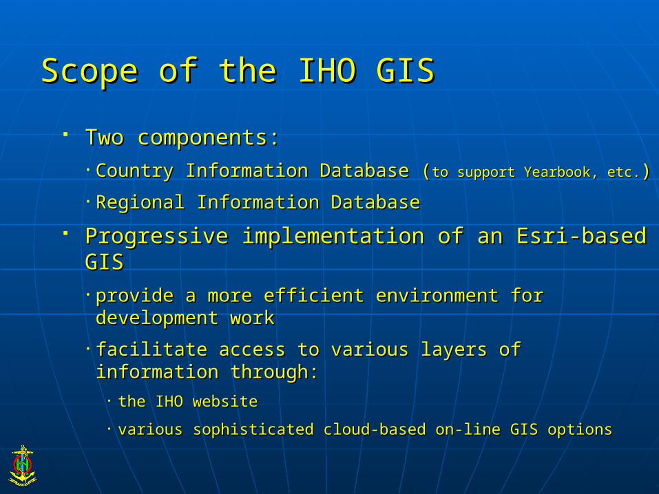
Scope of the IHO GISScope of the IHO GIS
Two components:Two components:• Country Information Database (Country Information Database (to support Yearbook, etc.to support Yearbook, etc.))• Regional Information DatabaseRegional Information Database
Progressive implementation of an Esri-based GISProgressive implementation of an Esri-based GIS• provide a more efficient environment for development workprovide a more efficient environment for development work• facilitate access to various layers of information through:facilitate access to various layers of information through:
• the IHO websitethe IHO website
• various sophisticated cloud-based on-line GIS optionsvarious sophisticated cloud-based on-line GIS options
ContentsContents Scope of the IHO GISScope of the IHO GIS
IHO Country Information DatabaseIHO Country Information Database
IHO ENC CatalogueIHO ENC Catalogue
C-55 DevelopmentC-55 Development
INToGIS ProjectINToGIS Project
Way aheadWay ahead

IHO Country Information DatabaseIHO Country Information Database
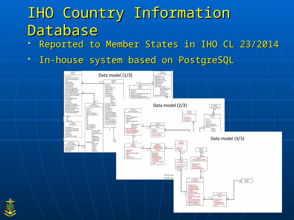
IHO Country Information DatabaseIHO Country Information Database Reported to Member States in IHO CL 23/2014Reported to Member States in IHO CL 23/2014 In-house system based on PostgreSQLIn-house system based on PostgreSQL

IHO Country Information DatabaseIHO Country Information Database
Collates information on IHO Member States (MS) Collates information on IHO Member States (MS) and other coastal Statesand other coastal States
Automated production of the IHO Yearbook (P-5) Automated production of the IHO Yearbook (P-5) and related listsand related lists
Access limited to IHB staff through the IHB internal Access limited to IHB staff through the IHB internal networknetwork
Future developmentsFuture developments• Interactive format for consulting P-5Interactive format for consulting P-5• Production of GIS layersProduction of GIS layers• Internet interface for updating the dataInternet interface for updating the data

ContentsContents Scope of the IHO GISScope of the IHO GIS
IHO Country Information SystemIHO Country Information System
IHO ENC CatalogueIHO ENC Catalogue
C-55 DevelopmentC-55 Development
INToGIS ProjectINToGIS Project
Way aheadWay ahead

Objectives of the IHO ENC CatalogueObjectives of the IHO ENC Catalogue• Draft IMO MSC Circular on ECDIS – Guidance for Good PracticeDraft IMO MSC Circular on ECDIS – Guidance for Good Practice(HTW 2/19 – Annex 8)(HTW 2/19 – Annex 8)
““The IHO provides an online chart catalogue that details the coverage of ENCs together The IHO provides an online chart catalogue that details the coverage of ENCs together with references to coastal State guidance on any requirements for paper charts with references to coastal State guidance on any requirements for paper charts (where this has been provided). The catalogue also provides links to IHO Member (where this has been provided). The catalogue also provides links to IHO Member States’ websites where additional information may be found. The IHO online chart States’ websites where additional information may be found. The IHO online chart catalogue can be accessed from the IHO website.catalogue can be accessed from the IHO website.””
• IHO Strategic Performance Indicator No.2IHO Strategic Performance Indicator No.2
““Growth in ENC coverage worldwide, as reported in the IHO on-line catalogue, relative Growth in ENC coverage worldwide, as reported in the IHO on-line catalogue, relative to the existing gap in adequate coverage (as defined by IMO/NAV) from the to the existing gap in adequate coverage (as defined by IMO/NAV) from the benchmark 01 Aug. 2008”benchmark 01 Aug. 2008”

Outline of the current systemOutline of the current system..
ENC metadata extracted from AVCS and stored on IHB serverENC metadata extracted from AVCS and stored on IHB server WFS uploaded to ArcGIS online for external consultationWFS uploaded to ArcGIS online for external consultation
WFSupload
IHB
web page based on ArcGIS online
UserBrowse and searchENC coverage
Metadata
AVCS
The catalogue can be accessed The catalogue can be accessed from the IHO web site at:from the IHO web site at:www.iho.int > ENCs & ECDIS > www.iho.int > ENCs & ECDIS > ENC ENC AvailabilityAvailability..

Information flow in the futureInformation flow in the future
ENC metadata will be accumulated from all relevant sourcesENC metadata will be accumulated from all relevant sources WFS uploaded to ArcGIS online for external consultationWFS uploaded to ArcGIS online for external consultation
WFSupload
IHB
web page based on ArcGIS online
User
Metadata
Browse and searchENC coverage

Demonstration - Simple interface Demonstration - Simple interface
Side bar (legend, layer select, base map select and print)

Demonstration - Layered informationDemonstration - Layered information
Multiple layers

Demonstration - Selection of lDemonstration - Selection of layersayers
Selectable layers by usage band

Demonstration - SettingsDemonstration - Settings
Settings:-transparency-sequence of the layers

Demonstration - AttributesDemonstration - Attributes
Pop up window providing detailed informationon clicking the feature
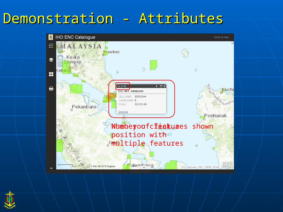
Demonstration - AttributesDemonstration - Attributes
When you click a position with multiple featuresNumber of features shown

Demonstration - AttributesDemonstration - Attributes
Detailed information can be displayed on request

Demonstration - Overlay with other informationDemonstration - Overlay with other information
Overlaid with the other layer
Port information derived from “World Port Index” of NGA PUB.150Port information derived from “World Port Index” of NGA PUB.150
ContentsContents Scope of the IHO GISScope of the IHO GIS
IHO Country Information SystemIHO Country Information System
IHO ENC CatalogueIHO ENC Catalogue
C-55 DevelopmentC-55 Development
INToGIS ProjectINToGIS Project
Way aheadWay ahead

C-55 DevelopmentC-55 Development www.iho.int > Standards & Publications > Download > C-55 > Standards & Publications > Download > C-55

C-55 DevelopmentC-55 Development Transfer of the current content of C-55 (composite indicators) into Transfer of the current content of C-55 (composite indicators) into
a database structurea database structure
Assessment of spatial analysis and graphical displaysAssessment of spatial analysis and graphical displays• pick report, pick report, • colour overlays associated with significant features (EEZ, coastline, etc.)colour overlays associated with significant features (EEZ, coastline, etc.)
Revision of the update procedure (user friendly interface)Revision of the update procedure (user friendly interface)
Future developments:Future developments:
• inclusion of CATZOC polygons to provide an initial geo-referenced quality inclusion of CATZOC polygons to provide an initial geo-referenced quality layer (as discussed at IRCC-4)layer (as discussed at IRCC-4)
RENCs are invited to seek the consent of their members to provide CATZOC RENCs are invited to seek the consent of their members to provide CATZOC information to the IHB for inclusion in C-55information to the IHB for inclusion in C-55

ContentsContents Scope of the IHO GISScope of the IHO GIS
IHO Country Information SystemIHO Country Information System
IHO ENC CatalogueIHO ENC Catalogue
C-55 DevelopmentC-55 Development
INToGIS ProjectINToGIS Project
Way aheadWay ahead

Background, ObjectivesBackground, Objectives Transfer of the S-11 Part B (all INT Chart Regions) into the IHO Transfer of the S-11 Part B (all INT Chart Regions) into the IHO
GIS Environment and provision of associated web services to GIS Environment and provision of associated web services to IHO MSIHO MS
From pdf versions …to web services (maintenance tools, search From pdf versions …to web services (maintenance tools, search functions, possibility of queries and statistical analysis, functions, possibility of queries and statistical analysis, uploading/downloading functions, track history…)uploading/downloading functions, track history…)
For who? For who? IHO MS, IHO MS, International Charting Coordination WGs / INT Chart International Charting Coordination WGs / INT Chart
Coordinators, IHBCoordinators, IHB
More dynamic and straightforward updating process… but iaw S-11 More dynamic and straightforward updating process… but iaw S-11 Part A “policy” and rights managementPart A “policy” and rights management
Foundation: Version-controlled of Regional Databases (... Foundation: Version-controlled of Regional Databases (... Region B, Region B, version 3.0.2, March 2016,.. version 3.0.2, March 2016,.. ), S-100-compliant model), S-100-compliant model
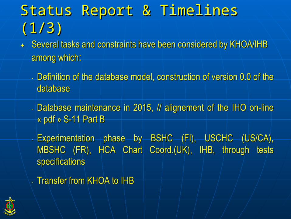
Status Report & Timelines (1/3)Status Report & Timelines (1/3)

20142014 Initial developments by KHOA and Project DefinitionInitial developments by KHOA and Project Definition
12 Jan 201512 Jan 2015 First formal project meetingFirst formal project meeting
27 March 27 March Delivery of S-11 Part B GIS Database version 0.0, Delivery of S-11 Part B GIS Database version 0.0, QC/QA by IHBQC/QA by IHB
May-July May-July Experimentation phase by FI, US/CA, FR, UK, IHBExperimentation phase by FI, US/CA, FR, UK, IHB
AugustAugust Experimentation summary report by IHB to KHOAExperimentation summary report by IHB to KHOA
Sept-Oct Sept-Oct Upgrade requests to be considered by KHOAUpgrade requests to be considered by KHOA
Status Report & Timelines (2/3)Status Report & Timelines (2/3)

10-13 Nov 10-13 Nov Presentation at HSSC-7 Presentation at HSSC-7
Nov.-DecNov.-Dec Database and ownership transfer from KHOA to IHBDatabase and ownership transfer from KHOA to IHB
15 Dec 2015 15 Dec 2015 IHO CL for commissioning S-11 Part B GIS database IHO CL for commissioning S-11 Part B GIS database and associated webservicesand associated webservices
At RHCs meetings in 2015: At RHCs meetings in 2015: Information and Update Reports (IHB)Information and Update Reports (IHB)
1 Jan 2016 1 Jan 2016 S-11 Part B GIS is operational, associated docs to S-11 Part B GIS is operational, associated docs to followfollow
Status Report & Timelines (3/3)Status Report & Timelines (3/3)

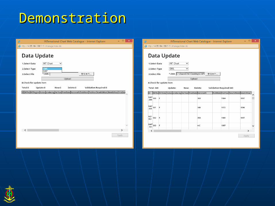
DemonstrationDemonstration
http://14.35.194.138:5151/iho/main.dohttp://14.35.194.138:5151/iho/main.do

DemonstrationDemonstration

DemonstrationDemonstration

INTChartID INTRegion
INTChartNumber
Producers
NatChartNumber TITLE / TITRE S_Lim
itN_Lim
itW_Lim
itE_Limi
tScal
eScaleLatitude
1st Ed
NewEditionYear
PrinterNation
Printer Nat.No.
Printer Date NE
NWF-300 F 300IT 360 Mare Mediterraneo e Mar Nero
25°00.00'N
49°50.33'N
7°00.00'W
42°15.50'W
420000041°30'N 198
4 1997
ESFRGBHR
7
4300
2008
2003
ProducingStatus
Printformat
FormerINTNo Comment ChartT
ypeStatus
InclusionYear
PublicationWeek
NewEditionWeek
FrameDimensions
RecordUpdateDate
PanelID
NatTitle1
NatTitle2
Projection
Produced A0
Chart proposed by Greece and adopted during the 13th MBSHC Conference (2003), with a reserve from Turkey / Carte proposée par la Grèce et adoptée à l’occasion de la 13e conférence CHMMN (2003), avec une réserve de la Turquie
DemonstrationDemonstration
DemonstrationDemonstration

ContentsContents Scope of the IHO GISScope of the IHO GIS
IHO Country Information SystemIHO Country Information System
IHO ENC CatalogueIHO ENC Catalogue
C-55 DevelopmentC-55 Development
INToGIS ProjectINToGIS Project
Way aheadWay ahead

Way ahead: towards the IHO GIS…Way ahead: towards the IHO GIS…
Interfacing / full integration of the components into the IHO GIS Interfacing / full integration of the components into the IHO GIS environmentenvironment
Overlay with other information(INT charts, RHC areas, Maritime Overlay with other information(INT charts, RHC areas, Maritime Shipping Routes, Ports, etc.) Shipping Routes, Ports, etc.)
Generation of Regional GIS (i.e.: Antarctica GIS)Generation of Regional GIS (i.e.: Antarctica GIS)
Generation of SPI, WPI…Generation of SPI, WPI…
GIS portal for all the IHO geospatial informationGIS portal for all the IHO geospatial information

Questions?Questions?