Embed Size (px)
Citation preview
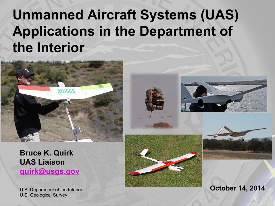
Unmanned Aircraft Systems (UAS) Applications in the Department of the Interior
U.S. Department of the Interior U.S. Geological Survey
Bruce K. Quirk UAS Liaison [email protected]
October 14, 2014
2
Sim
plify
St
anda
rdiz
e M
easu
re
2
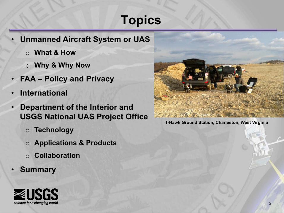
Topics • Unmanned Aircraft System or UAS
o What & How
o Why & Why Now
• FAA – Policy and Privacy
• International
• Department of the Interior and USGS National UAS Project Office o Technology
o Applications & Products
o Collaboration
• Summary
T-Hawk Ground Station, Charleston, West Virginia
3
Sim
plify
St
anda
rdiz
e M
easu
re
3
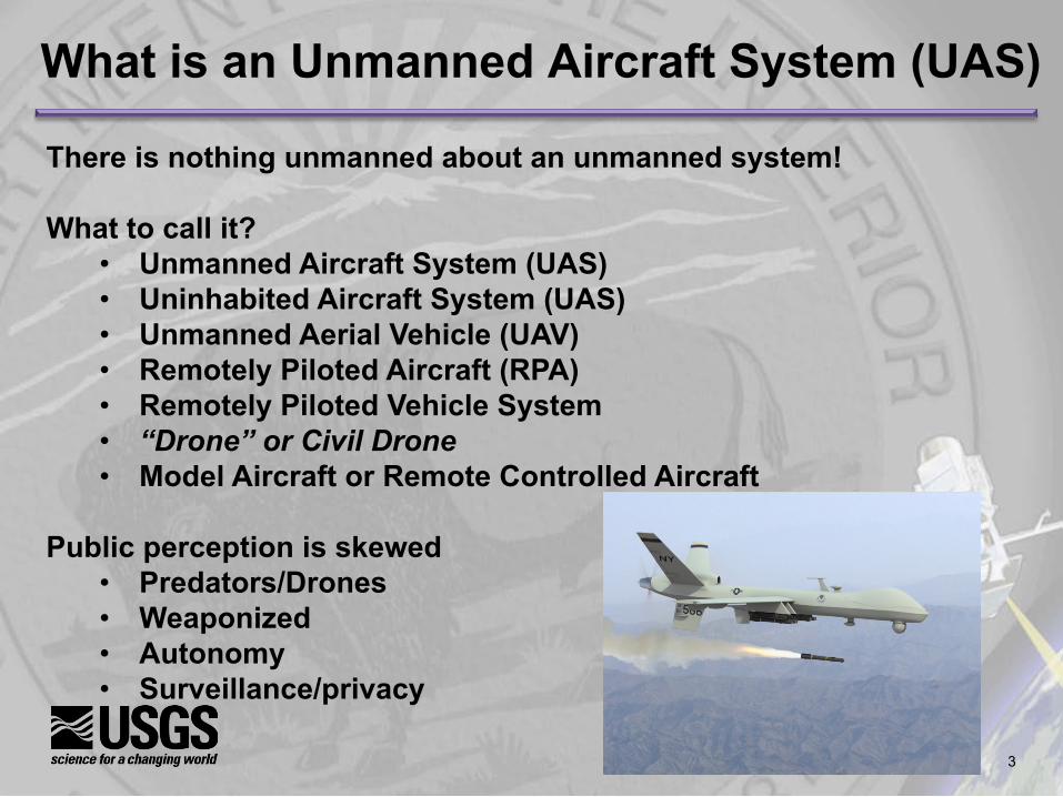
What is an Unmanned Aircraft System (UAS)
There is nothing unmanned about an unmanned system! What to call it?
• Unmanned Aircraft System (UAS) • Uninhabited Aircraft System (UAS) • Unmanned Aerial Vehicle (UAV) • Remotely Piloted Aircraft (RPA) • Remotely Piloted Vehicle System • “Drone” or Civil Drone • Model Aircraft or Remote Controlled Aircraft
Public perception is skewed
• Predators/Drones • Weaponized • Autonomy • Surveillance/privacy

4
Sim
plify
St
anda
rdiz
e M
easu
re
4
Different Types of “Drones”

5
Sim
plify
St
anda
rdiz
e M
easu
re
5
How a UAS Works
Line-of-Sight (LOS)
DOI mode of operation
Beyond-Line-of-Sight (BLOS)
6
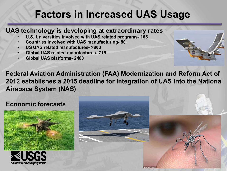
Factors in Increased UAS Usage UAS technology is developing at extraordinary rates
• U.S. Universities involved with UAS related programs- 165 • Countries involved with UAS manufacturing- 80 • US UAS related manufactures- >800 • Global UAS related manufactures- 715 • Global UAS platforms- 2400
Federal Aviation Administration (FAA) Modernization and Reform Act of 2012 establishes a 2015 deadline for integration of UAS into the National Airspace System (NAS) Economic forecasts

7
UAS Economic Potential AUVSI’s 2013 Economic Report
• The UAS global market is currently $11.3 billion
• Over the next 10 years, the UAS global market will total $140 billion
• The economic impact of U.S. airspace integration will total over $13.6 billion in the first three years and will grow sustainably for the foreseeable future, cumulating to over $82.1 billion between 2015 and 2025
• Every year that airspace integration is delayed will cost the U.S. over $10 billion in lost potential economic impact, which translates to $27 million per day
(www.auvsi.org/econreport)
8
Sim
plify
St
anda
rdiz
e M
easu
re
8
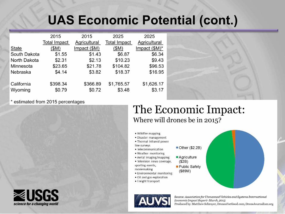
UAS Economic Potential (cont.)
9
Sim
plify
St
anda
rdiz
e M
easu
re
9
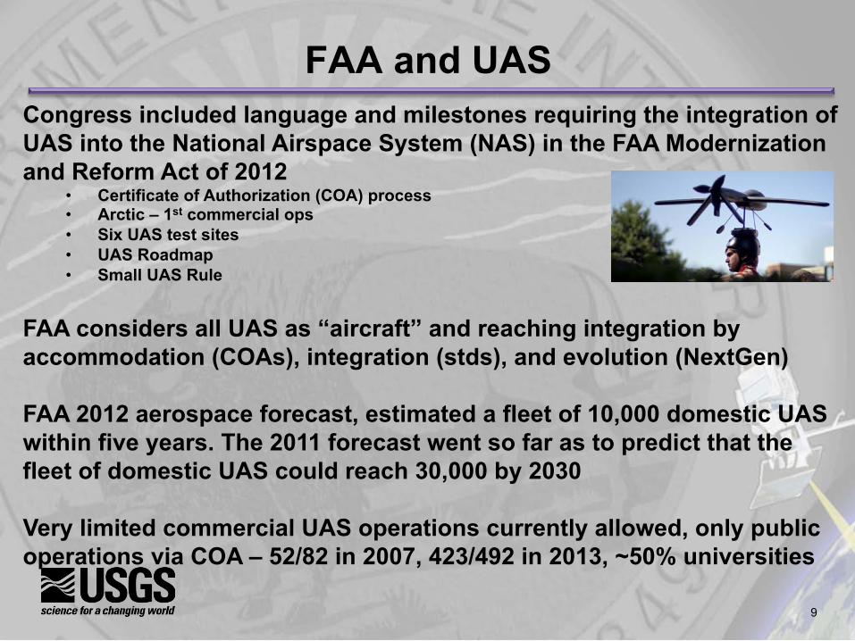
FAA and UAS Congress included language and milestones requiring the integration of UAS into the National Airspace System (NAS) in the FAA Modernization and Reform Act of 2012
• Certificate of Authorization (COA) process • Arctic – 1st commercial ops • Six UAS test sites • UAS Roadmap • Small UAS Rule
FAA considers all UAS as “aircraft” and reaching integration by accommodation (COAs), integration (stds), and evolution (NextGen)
FAA 2012 aerospace forecast, estimated a fleet of 10,000 domestic UAS within five years. The 2011 forecast went so far as to predict that the fleet of domestic UAS could reach 30,000 by 2030 Very limited commercial UAS operations currently allowed, only public operations via COA – 52/82 in 2007, 423/492 in 2013, ~50% universities

10
Sim
plify
St
anda
rdiz
e M
easu
re
10
FAA and UAS (cont.) • Test site progress, see map, includes privacy policy for test sites • Agreements with Federal agencies, including DOI, to streamline
operations • Small UAS Notice of Proposed Rule Making (NPRM), late 2014 • Several lawsuits
o Raphael Pirker o Texas EquuSearch o Model aircraft hobbyists o Research universities o Commercial drone interests
11
Sim
plify
St
anda
rdiz
e M
easu
re
11
FAA and UAS (cont.) Commercial operations • Arctic – over ocean (2013) and land (2014 pipeline inspections) • FAA can grant exemptions under section 333 of the FAA Modernization and
Reform Act • Granted regulatory exemptions to 6 aerial photo and video production
companies, the first step to allowing the film and television industry the use of UAS in the NAS, 9/25/14
• Exemptions – film industry, oil (flare stack and pipeline inspections), agriculture, as of October 2 received 57 requests, approved 6 (film)
Center of Excellence for Unmanned Aircraft Systems RFP, Aug 2014 from Congressional Consolidated Appropriations Act 2014 • Relationship to 6 test sites and FAA Technology Center UAS activities Where you can fly tools – https://www.mapbox.com/drone/no-fly/
12
Sim
plify
St
anda
rdiz
e M
easu
re
12
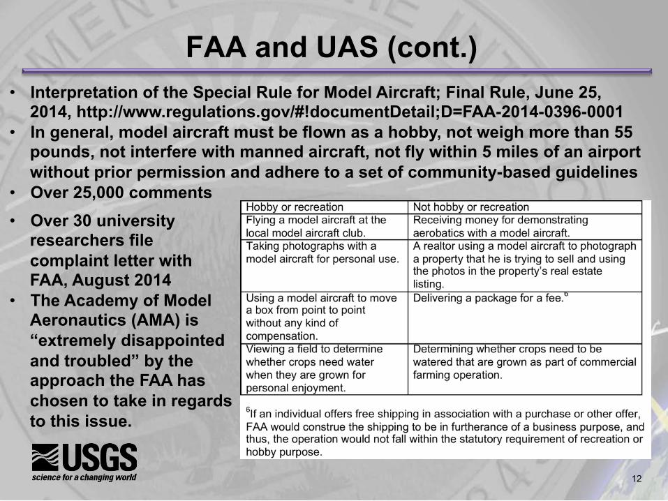
FAA and UAS (cont.) • Interpretation of the Special Rule for Model Aircraft; Final Rule, June 25,
2014, http://www.regulations.gov/#!documentDetail;D=FAA-2014-0396-0001 • In general, model aircraft must be flown as a hobby, not weigh more than 55
pounds, not interfere with manned aircraft, not fly within 5 miles of an airport without prior permission and adhere to a set of community-based guidelines
• Over 25,000 comments • Over 30 university
researchers file complaint letter with FAA, August 2014
• The Academy of Model Aeronautics (AMA) is “extremely disappointed and troubled” by the approach the FAA has chosen to take in regards to this issue.

13
Sim
plify
St
anda
rdiz
e M
easu
re
13
FAA and UAS (cont.) • “FAA is making some progress in meeting UAS-related provisions of the
FAA Modernization and Reform Act of 2012, but the Agency is significantly behind schedule in meeting most of them, including the goal of achieving safe integration by September 2015. FAA has completed 9 of the act’s 17 UAS provisions, such as selecting 6 test sites, publishing a UAS Roadmap, and developing a comprehensive plan outlining FAA’s UAS plans in the near- and long-term. However, the Agency missed the statutory milestones for most of these provisions, and much work remains to fully implement them. FAA is also behind schedule in implementing the remaining eight UAS provisions. For example, FAA will not meet the August 2014 milestone for issuing a final rule on small UAS operations. FAA’s delays are due to unresolved technological, regulatory, and privacy issues, which will prevent FAA from meeting Congress’ September 30, 2015, deadline for achieving safe UAS integration. As a result, while it is certain that FAA will accommodate UAS operations at limited locations, it is uncertain when and if full integration of UAS into the NAS will occur.” DOT IG Audit Report June 26, 2014
14
Sim
plify
St
anda
rdiz
e M
easu
re
14
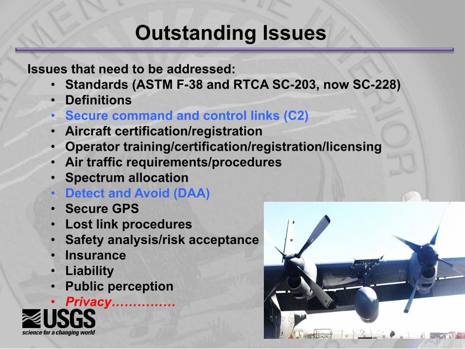
Outstanding Issues Issues that need to be addressed:
• Standards (ASTM F-38 and RTCA SC-203, now SC-228) • Definitions • Secure command and control links (C2) • Aircraft certification/registration • Operator training/certification/registration/licensing • Air traffic requirements/procedures • Spectrum allocation • Detect and Avoid (DAA) • Secure GPS • Lost link procedures • Safety analysis/risk acceptance • Insurance • Liability • Public perception • Privacy……………
15
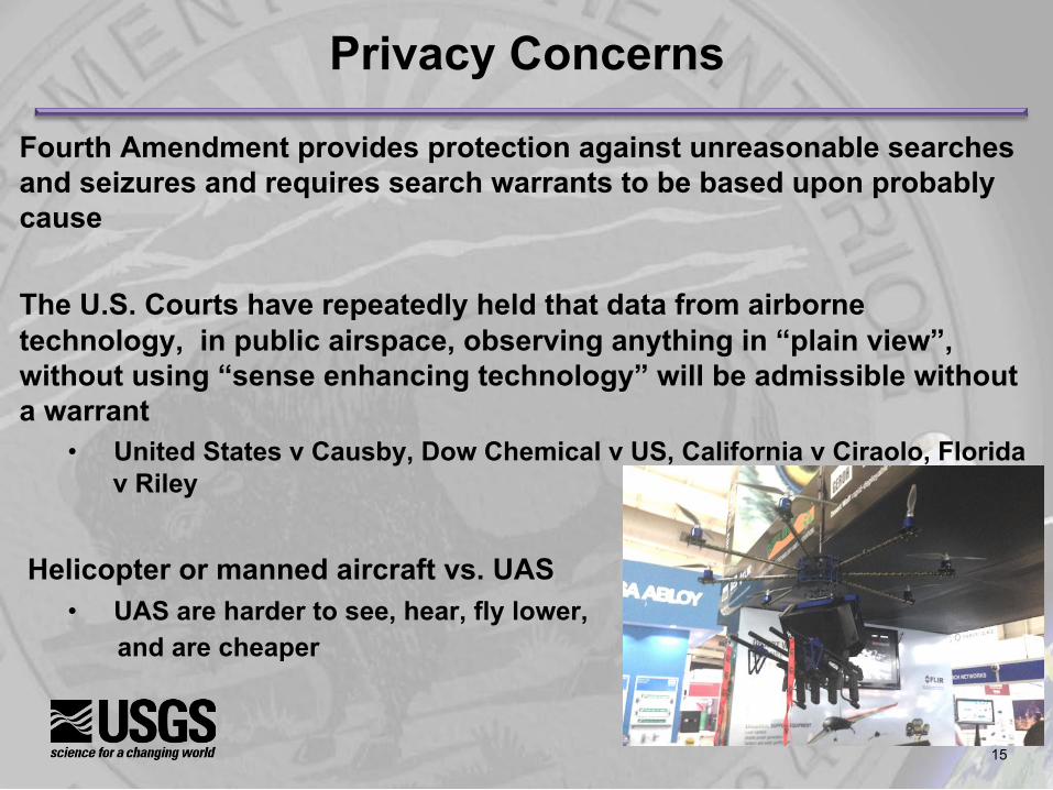
Privacy Concerns
Fourth Amendment provides protection against unreasonable searches
and seizures and requires search warrants to be based upon probably cause The U.S. Courts have repeatedly held that data from airborne technology, in public airspace, observing anything in “plain view”, without using “sense enhancing technology” will be admissible without a warrant
• United States v Causby, Dow Chemical v US, California v Ciraolo, Florida v Riley
Helicopter or manned aircraft vs. UAS • UAS are harder to see, hear, fly lower,
and are cheaper
16
Sim
plify
St
anda
rdiz
e M
easu
re
16
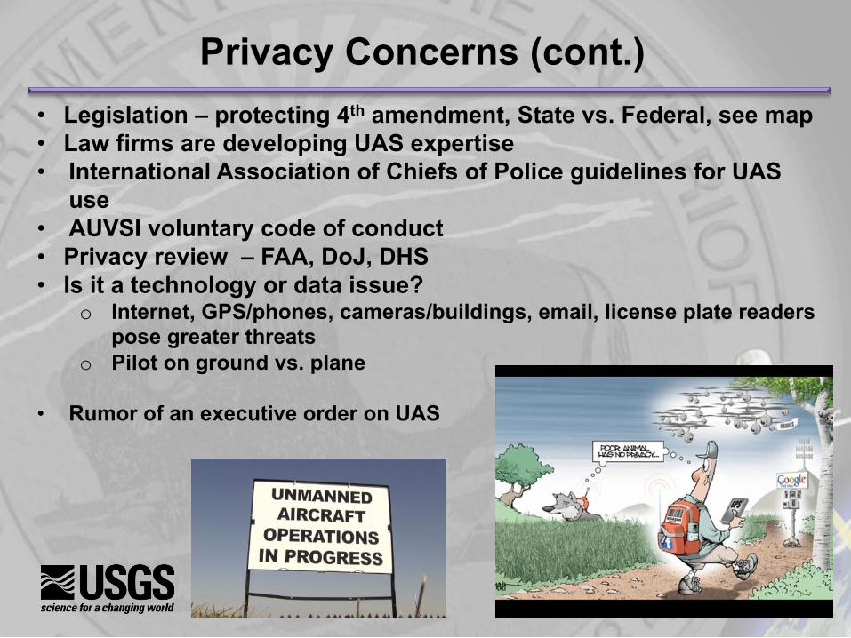
Privacy Concerns (cont.) • Legislation – protecting 4th amendment, State vs. Federal, see map • Law firms are developing UAS expertise • International Association of Chiefs of Police guidelines for UAS
use • AUVSI voluntary code of conduct • Privacy review – FAA, DoJ, DHS • Is it a technology or data issue?
o Internet, GPS/phones, cameras/buildings, email, license plate readers pose greater threats
o Pilot on ground vs. plane
• Rumor of an executive order on UAS
17
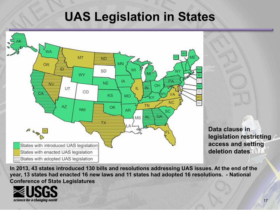
UAS Legislation in States
In 2013, 43 states introduced 130 bills and resolutions addressing UAS issues. At the end of the year, 13 states had enacted 16 new laws and 11 states had adopted 16 resolutions. - National Conference of State Legislatures
Data clause in legislation restricting access and setting deletion dates

18
International
sUAS news Dec 3, 2013
Canada has granted nearly 1,500 “Special Flight Operations Certificates” in the last
three years DHL has received authorization to start regular drone delivery flights to an island in the North Sea about 7.5 miles off the coast of Germany - DHL parcelcopter

19
Japan
Sato, Akira (2011, October). Civil UAV Applications in Japan and Related Safety & Certification. Presented at the 1st Annual Agricultural UAS Conference: Precision Agriculture, Atlanta, GA.
20
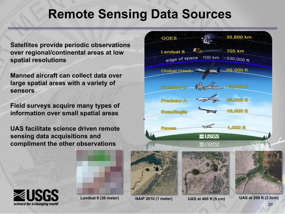
Satellites provide periodic observations over regional/continental areas at low spatial resolutions Manned aircraft can collect data over large spatial areas with a variety of sensors Field surveys acquire many types of information over small spatial areas UAS facilitate science driven remote sensing data acquisitions and compliment the other observations
Remote Sensing Data Sources
Landsat 8 (30 meter) NAIP 2010 (1 meter) UAS at 400 ft (5 cm) UAS at 200 ft (2.5cm)
21
Sim
plify
St
anda
rdiz
e M
easu
re
21
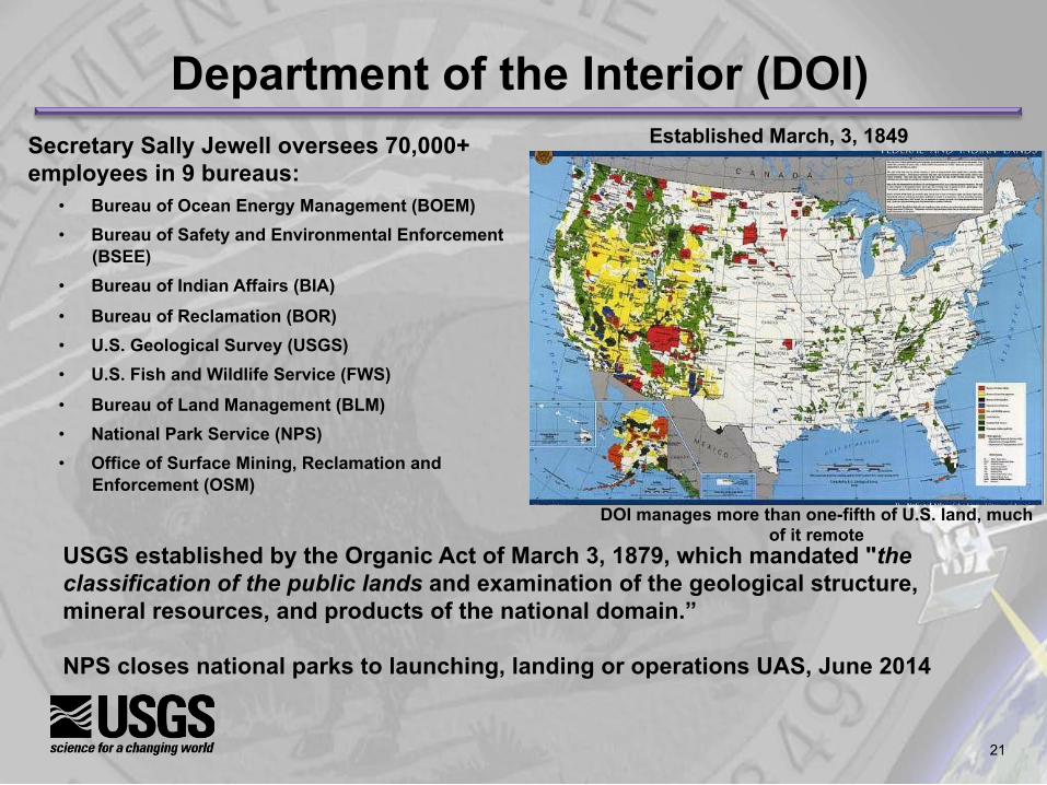
Department of the Interior (DOI) Secretary Sally Jewell oversees 70,000+ employees in 9 bureaus:
• Bureau of Ocean Energy Management (BOEM) • Bureau of Safety and Environmental Enforcement
(BSEE) • Bureau of Indian Affairs (BIA)
• Bureau of Reclamation (BOR) • U.S. Geological Survey (USGS) • U.S. Fish and Wildlife Service (FWS)
• Bureau of Land Management (BLM) • National Park Service (NPS) • Office of Surface Mining, Reclamation and
Enforcement (OSM)
Established March, 3, 1849
USGS established by the Organic Act of March 3, 1879, which mandated "the classification of the public lands and examination of the geological structure, mineral resources, and products of the national domain.” NPS closes national parks to launching, landing or operations UAS, June 2014
DOI manages more than one-fifth of U.S. land, much of it remote
22
What is the UAS Strategy
DOI’s UAS program strategy is tailored to the mission, funding, personnel, and infrastructure levels of the Department and is summarized as: • Focus on small UAS (sUAS), which are more aligned with DOI’s
decentralized mission execution strategy and more supportable by the Department’s funding, personnel and infrastructure levels.
• Leverage available excess DOD sUAS to minimize procurement, training, and support costs.
• Establish partnerships with Federal departments who possess UAS capabilities beyond DOI’s to support DOI missions that require more extensive UAS capabilities.
• Conduct operational tests and evaluations of various UAS technologies to support the development of long-range UAS requirements and strategy for the DOI UAS activities.
• Based on the requirements and strategy developed above, procure (buy or contract) for UAS capabilities that cannot be met either through excess DOD sUAS or those available through partnerships with other Federal agencies.
23
The tangible benefits of the DOI UAS operational test and evaluation phase can be summed up in three words: Science, Safety, and Savings. Examples of these tangible benefits include: • UAS are far less disruptive to sensitive animal species than manned aircraft. They carry high tech
sensors and possess the ability to transmit real-time data that can also be recorded for future analysis. Many offer greater airborne persistence and launch responsiveness than manned aircraft. These unique characteristics enable UAS to gather repeatable, scientifically valid observations. Better science leads to better policy decisions, which benefits all Americans.
• DOI missions often expose personnel to significant safety hazards. From 1937 to 2000, 66% of all field biologist fatalities in DOI were aviation-related. UAS have also been used to replace ground personnel in certain missions, reducing their risk to injury. UAS is one tool DOI is evaluating as part of its program to improve safety.
• The cost to operate sUAS, under 55 pounds, currently employed by DOI is less than 10 percent of the cost to operate manned aircraft. FWS and USGS estimated the Sandhill Crane UAS mission costs at $2,500. Estimates to fly a similarly equipped manned aircraft were over $25,000.
New agreement between the FAA and Department supports “file and fly” approach to UAS flights
Tangible Benefits
24
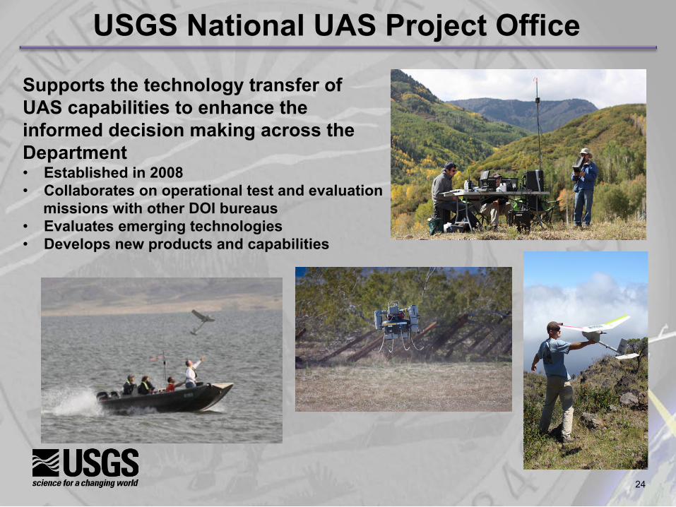
USGS National UAS Project Office
Supports the technology transfer of UAS capabilities to enhance the informed decision making across the Department • Established in 2008 • Collaborates on operational test and evaluation
missions with other DOI bureaus • Evaluates emerging technologies • Develops new products and capabilities
25
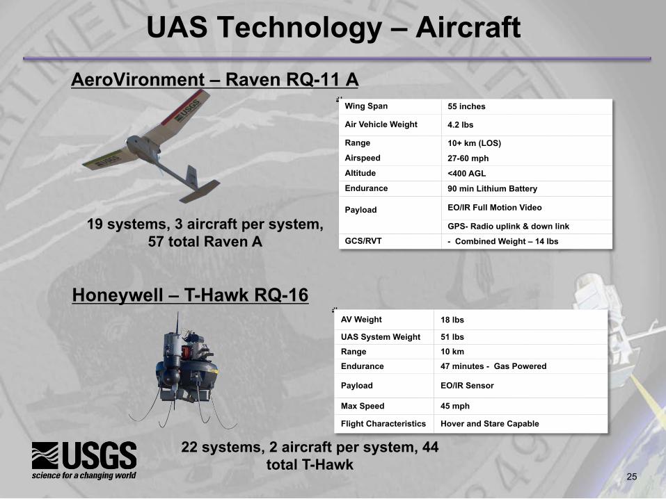
UAS Technology – Aircraft AeroVironment – Raven RQ-11 A
Wing Span 55 inches
Air Vehicle Weight 4.2 lbs
Range 10+ km (LOS)
Airspeed 27-60 mph
Altitude <400 AGL
Endurance 90 min Lithium Battery
Payload
EO/IR Full Motion Video
GPS- Radio uplink & down link
GCS/RVT - Combined Weight – 14 lbs
AV Weight 18 lbs
UAS System Weight 51 lbs
Range 10 km
Endurance 47 minutes - Gas Powered
Payload EO/IR Sensor
Max Speed 45 mph
Flight Characteristics Hover and Stare Capable
Honeywell – T-Hawk RQ-16
19 systems, 3 aircraft per system, 57 total Raven A
22 systems, 2 aircraft per system, 44 total T-Hawk

26
Existing • Natural Color Video • Thermal IR Video
UAS Technology - Sensors
Current Enhancements • GoPro Hero 2 & 3 - 1080P HD camera (still frame and video)
• Canon SX260HS & S100 – GPS enabled (RGB and IR) – CHDK
• Sony ActionCam – GPS enabled
• Ricoh GR – no GPS
• I-buttons (temp. & humidity)
Future Investigations • Multispectral, Hyperspectral • LIDAR, RADAR, Thermal • Chemical/Air Sampling • Radio Relay/Tracking
27
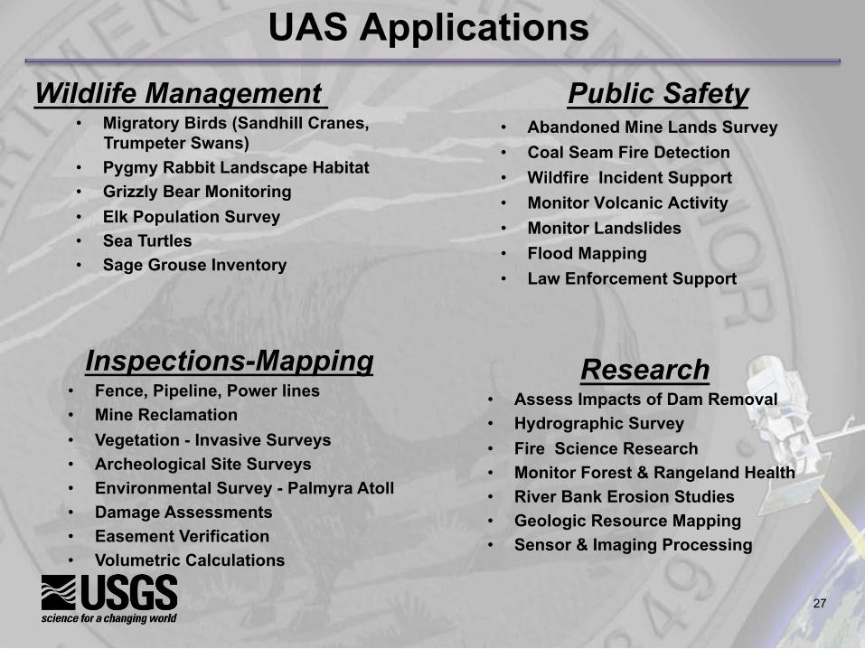
Public Safety
• Abandoned Mine Lands Survey • Coal Seam Fire Detection • Wildfire Incident Support • Monitor Volcanic Activity • Monitor Landslides • Flood Mapping • Law Enforcement Support
Research • Assess Impacts of Dam Removal • Hydrographic Survey • Fire Science Research • Monitor Forest & Rangeland Health • River Bank Erosion Studies • Geologic Resource Mapping • Sensor & Imaging Processing
UAS Applications
Inspections-Mapping • Fence, Pipeline, Power lines • Mine Reclamation • Vegetation - Invasive Surveys • Archeological Site Surveys • Environmental Survey - Palmyra Atoll • Damage Assessments • Easement Verification • Volumetric Calculations
Wildlife Management • Migratory Birds (Sandhill Cranes,
Trumpeter Swans) • Pygmy Rabbit Landscape Habitat • Grizzly Bear Monitoring • Elk Population Survey • Sea Turtles • Sage Grouse Inventory
28
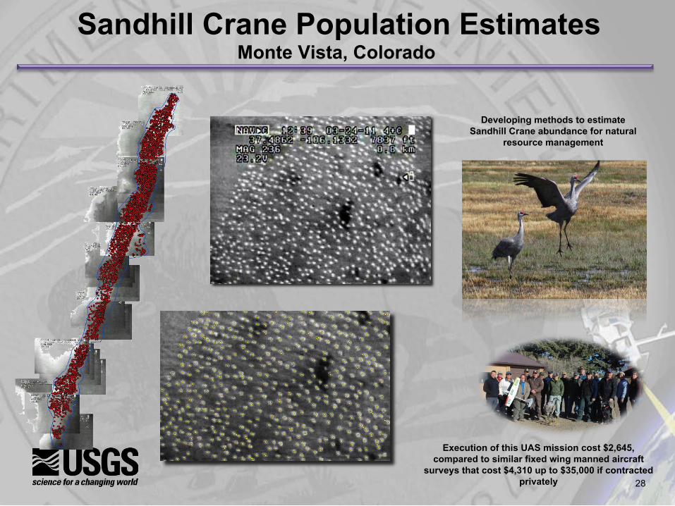
Sandhill Crane Population Estimates Monte Vista, Colorado
Developing methods to estimate Sandhill Crane abundance for natural
resource management
Execution of this UAS mission cost $2,645, compared to similar fixed wing manned aircraft
surveys that cost $4,310 up to $35,000 if contracted privately
29
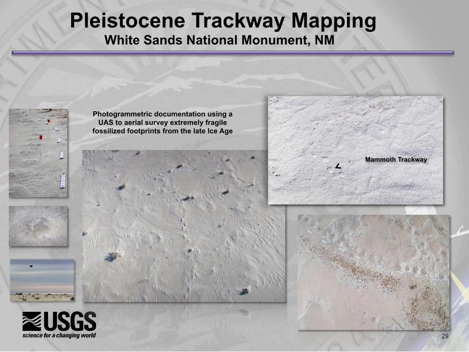
Pleistocene Trackway Mapping White Sands National Monument, NM
Mammoth Trackway
Photogrammetric documentation using a UAS to aerial survey extremely fragile
fossilized footprints from the late Ice Age
30
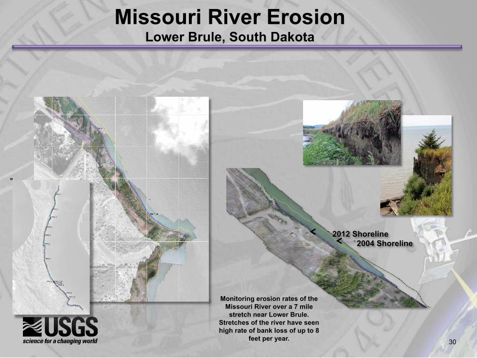
Missouri River Erosion Lower Brule, South Dakota
2004 Shoreline 2012 Shoreline
Monitoring erosion rates of the Missouri River over a 7 mile
stretch near Lower Brule. Stretches of the river have seen high rate of bank loss of up to 8
feet per year.
31

32
Elwha Dam Removal and River Restoration Olympic National Park, Washington
Monitoring sediment volumes eroded from
the reservoir and deposited
downstream, where the mobile sediment can potentially affect salmon habitat and
flood-stage elevation
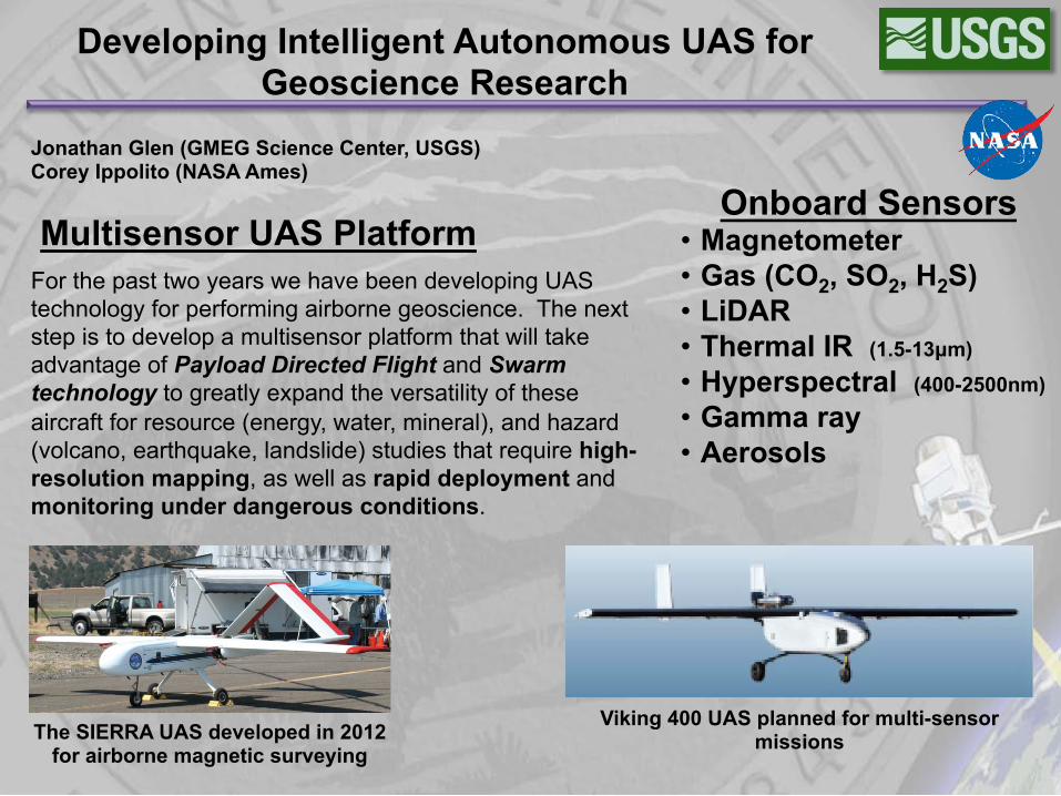
The SIERRA UAS developed in 2012 for airborne magnetic surveying
Viking 400 UAS planned for multi-sensor missions
Developing Intelligent Autonomous UAS for Geoscience Research
For the past two years we have been developing UAS technology for performing airborne geoscience. The next step is to develop a multisensor platform that will take advantage of Payload Directed Flight and Swarm technology to greatly expand the versatility of these aircraft for resource (energy, water, mineral), and hazard (volcano, earthquake, landslide) studies that require high-resolution mapping, as well as rapid deployment and monitoring under dangerous conditions.
Multisensor UAS Platform Onboard Sensors
• Magnetometer • Gas (CO2, SO2, H2S) • LiDAR • Thermal IR (1.5-13µm) • Hyperspectral (400-2500nm) • Gamma ray • Aerosols
Jonathan Glen (GMEG Science Center, USGS) Corey Ippolito (NASA Ames)
34
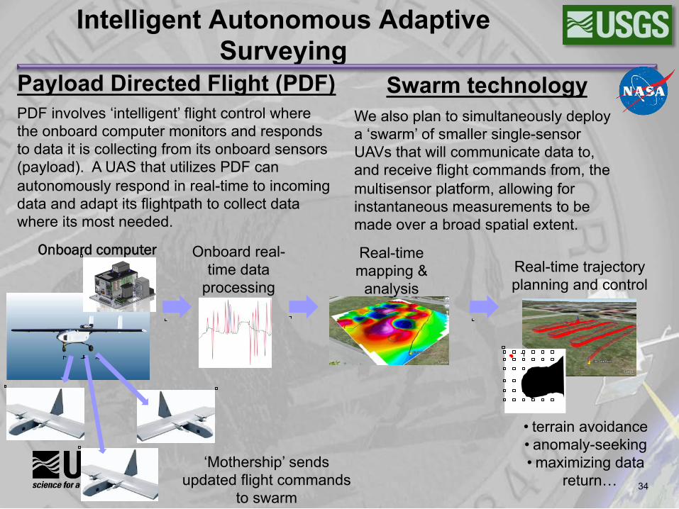
Intelligent Autonomous Adaptive Surveying
• terrain avoidance • anomaly-seeking • maximizing data
return…
Onboard real-time data
processing
Onboard computer Real-time mapping &
analysis Real-time trajectory planning and control
Payload Directed Flight (PDF)
PDF involves ‘intelligent’ flight control where the onboard computer monitors and responds to data it is collecting from its onboard sensors (payload). A UAS that utilizes PDF can autonomously respond in real-time to incoming data and adapt its flightpath to collect data where its most needed.
Swarm technology
We also plan to simultaneously deploy a ‘swarm’ of smaller single-sensor UAVs that will communicate data to, and receive flight commands from, the multisensor platform, allowing for instantaneous measurements to be made over a broad spatial extent.
‘Mothership’ sends updated flight commands
to swarm
35
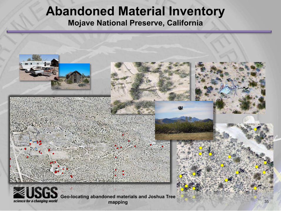
Abandoned Material Inventory Mojave National Preserve, California
Geo-locating abandoned materials and Joshua Tree mapping
36
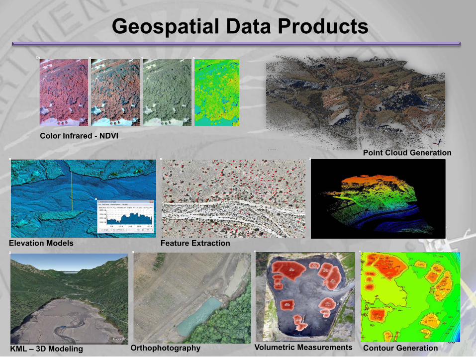
Geospatial Data Products
Color Infrared - NDVI
Point Cloud Generation
Elevation Models Feature Extraction
KML – 3D Modeling Orthophotography Contour Generation Volumetric Measurements
37
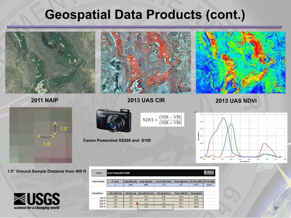
2011 NAIP 2013 UAS CIR 2013 UAS NDVI
Geospatial Data Products (cont.)
1.5” Ground Sample Distance from 400 ft
1.5”
1.5”
100 ft 200 ft 300 ft 400 ft
Canon Powershot SX260 and S100
38
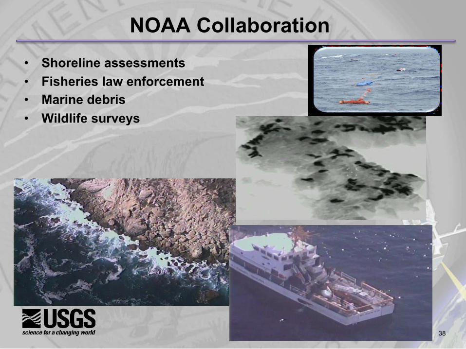
NOAA Collaboration • Shoreline assessments • Fisheries law enforcement • Marine debris • Wildlife surveys
39
The Department requires timely, high-quality, affordable data to meet its mission
• Remote sensing is a key source of these data and we are using remote sensing data acquired from both satellite and aircraft
• Declining budgets and increased acquisition costs have reduced the data from these sources
• UAS provide a flexible, low-risk and low-cost alternative – scientists can get the data they need, when they need it
The USGS will continue the operational test and evaluation phase, but will start to transition some activities to operations and investigate new sensors, products and applications
The USGS will continue to lead the evaluation and application of UAS technology in the Department and will continue working with the other bureaus, Federal agencies and universities
Carpe Caelum
40
Back-ups