Embed Size (px)
Citation preview

UNIVERSITI PUTRA MALAYSIA
DEVELOPING OF A MODEL FOR MEASURING AND EXTRACTING
OCEAN SURFACE CURRENT PATTERNS FROM RADARSAT-1 SAR AND ALTIMETER DATA
MOHAMED AHMED MAIYAS
FK 2007 28

DEVELOPING OF A MODEL FOR MEASURING AND EXTRACTING OCEAN SURFACE CURRENT PATTERNS FROM RADARSAT-1 SAR AND
ALTIMETER DATA
By
MOHAMED AHMED MAIYAS
Thesis Submitted to the School of Graduate Studies, Universiti Putra Malaysia in Fulfilment of the Requirements for the Degree of Doctor of Philosophy
MAY 2007

ii
DEDICATION
To the soul of my father
Who started dreaming of me to be a human rather than an educated person
and wished me to be a man of wisdom and positive thinking.
Today what I am is just because of his direction and affections
&
To the rest of my extended families
mother, brothers, sisters, wife and kids
your encouragement has seen me through this long journey

iii
Abstract of thesis presented to the Senate of Universiti Putra Malaysia in
fulfilment of the requirement for the degree of Doctor of Philosophy
DEVELOPING OF A MODEL FOR MEASURING AND EXTRACTING OCEAN SURFACE CURRENT PATTERNS FROM RADARSAT-1 SAR AND
ALTIMETER DATA
By
MOHAMED AHMED MAIYAS
May 2007
Chairman: Professor Shattri bin Mansor, PhD
Faculty: Engineering
Remote sensing technology can be used to collect large scale data on ocean areas
and provide precise information on ocean surface dynamics and atmospheric
interactions. Many other ocean surface features can be detected by utilizing this
technology. In this study, a robust model was developed based on Doppler
frequency that utilizes RADARSAT-1 SAR imageries in measuring and
extracting ocean surface current patterns such as velocity and direction. The
SAR data used in the study were acquired during the period 20-31 March 2005
and supported with altimeter data of GEOSAT-2 and TOPEX/POSEIDON also
collected at the same period. The study area is located between the longitudes
102°50'00'' to 103°40'00'' East and latitudes 5°25'00'' to 5°40'00'' North, at the east
coast of Kuala Terengganu. The area was divided into four main parts

iv
comprising the onshore, fieldwork area, midshore, and offshore area witch is
about 98 km. off the coast. The model was applied on the SAR image at three
different modes (Wide- 3, High extended- 6 and Standard-2) with the objectives
of 1) comparing between the modes and identifying the appropriate mode for
coastal current modeling, 2) modeling the spectral intensity of the SAR data in
the study area covering the onshore, midshore, offshore and the fieldwork area,
3) examining the impacts of tide and wind speed and direction on surface
current movements on the coastal water of Kuala Terengganu, Malaysia and 4)
investigating the impact of the Doppler frequency shift and incidence angle on
the sea surface current detection. The results of the study were validated using
TOPEX/POSEIDON satellite altimeter data for the same period and in situ data
measurements taken with AWAC instrument during the fieldwork. The study
did not only find that the incidence angle in SAR had an effect on the surface
current patterns but also that, there is a strong relation between the image
backscatter and Doppler frequency. It was again discovered that the velocity
and direction of the current changed through the period of the study according
to the changing of Doppler frequency shift used in the model to extract the sea
surface current velocity and direction from the three SAR images. At the
onshore area, the velocity of current extracted based on the Wide-3 mode
varied between 0.22 m/s to 0.25 m/s with the average of 0.24 m/s, while based
on the Standard-2 mode it varied between 0.52 m/s to 0.65 m/s with an

v
average velocity of 0.56 m/s. The analysis of the spectral intensity of the SAR
data in different modes showed variation among the four areas. The spectral
intensity values were low in the onshore as against the high values recorded in
the offshore. Regression analysis was used to establish the coefficient of
determination between the velocities extracted from SAR data and the AWAC
in situ measurements. The analysis showed a fairly high correlation between
them of R² of 0.753 with the highest velocity under 0.27 m/s, R² of 0.726 with the
highest velocity under 0.32 m/s and R² of 0.863 with the highest velocity under
0.75 m/s. These results were obtained from the regression between the AWAC
data and the RADARSAT-1 SAR in Wide-3, Extended High-6 and Standard-2
modes respectively. It can be said that the investigation between different radar
systems should be used as geomantic tool to investigate water current
movement.

vi
Abstrak tesis yang dikemukakan kepada Senat Unversiti Putra Malaysia sebagai
memenuhi keperluan untuk ijazah Doktor Falsafah
PEMODELAN CORAK ARUS PERMUKAAN LAUT DARI RADARSAT-1 SAR
DAN ALTIMETER DATA
Oleh
MOHAMED AHMED MAIYAS
Mei 2007
Pengerusi: Profesor Shattri bin Mansor, PhD
Fakulti: Kejuruteraan
Teknologi Penderiaan Jarak Jauh boleh digunakan untuk mengumpul data
berkenaan kawasan laut yang berskala besar dan dapat memberikan maklumat
terperinci dinamik permukaan lautan dan interaksi atmosfera. Ciri-ciri lain
permukaan laut juga boleh dikenalpasti dengan menggunakan teknologi ini.
Untuk penyelidikan ini, satu model tahan lasak dibina yang menggunakan imej-
imej RADARSAT-1 SAR dalam pengukuran dan pengasingan corak arus
permukaan laut seperti kelajuan dan arah. Data SAR yang digunakan dalam
penyelidikan ini diperolehi dalam tempoh 20-31 March 2005 dengan disokong
oleh data altimeter GEOSAT-2 dan TOPEX/POSEIDON yang turut dikumpul
dalam tempoh yang sama. Kawasan penyelidikan terletak di antara longitud

vii
102o50’00” hingga 103 o40’00” Timur dan latitud 52 o5’00” hingga 5 o40’00” Utara,
di timur perairan Kuala Terengganu. Kawasan tersebut terbahagi kepada empat
bahagian yang merangkumi persisiran dalam, kawasan lapangan kerja,
persisiran tengah dan persisiran luar iaitu lebih kurang 98 km daripada
persisiran pantai. Model tersebut digunakan ke atas imej SAR pada tiga mod
yang berlainan (Wide- 3, High extended- 6 dan Standard- 2) berdasarkan objektif
berikut 1) membandingkan antara mod dan mengenal pasti mod yang
bersesuaian untuk model arus perairan, 2) memodelkan intensiti spektral data
SAR dalam kawasan penyelidikan yang merangkumi persisiran dalam,
kawasan lapangan kerja, persisiran tengah dan persisiran luar, 3) mengkaji
impak kelajuan ombak dan angin dan arah ke atas pergerakan arus permukaan
perairan Kuala Terengganu, Malaysia dan 4) mengenalpasti impak anjakan
frekuensi Doppler dan sudut insiden ke atas pengenalpastian arus permukaan
lautan. Keputusan penyelidikan disahkan menggunakan data altimeter satelit
TOPEX/POSEIDON untuk tempoh masa yang sama dan data pengukuran in
situ diambil menggunakan alatan AWAC semasa kerja lapangan. Penyelidikan
ini tidak hanya menemui sudut insiden dalam SAR mempunyai kesan ke atas
corak arus permukaan tetapi juga terdapat kaitan yang kuat antara imej
serakan-belakang anjakan frekuensi Doppler yang digunakan dalam model
untuk mengasingkan kelajuan arus permukaan laut dan arah daripada tiga imej
SAR tersebut. Di kawasan persisiran dalam, kelajuan arus yang didapati

viii
berdasarkan kepada mod Wide-3 berubah antara 0.22 m/s hingga 0.25 m/s
dengan purata 0.24 m/s, manakala berdasarkan mod Standard-2 ia berubah
antara 0.52 m/s hingga 0.65 m/s dengan purata kelajuan 0.56 m/s. Analisis
intensiti spektral data SAR dalam pelbagai mod menunjukkan variasi antara ke
empat-empat kawasan. Nilai intensiti spektral adalah rendah di persisiran
dalam berbanding nilai yang tinggi di kawasan persisiran luar. Analisis regresi
digunakan untuk mendapatkan pekali penentuan antara kelajuan yang
diperolehi daripada data SAR dan pengukuran in situ AWAC. Analisis
menunjukkan korelasi yang agak tinggi antara data tersebut di mana R2 = 0.753
dengan kelajuan tertinggi pada 0.27 m/s, R2 = 0.726 dengan kelajuan tertinggi
pada 0.32 m/s dan R2 = 0.863 dengan kelajuan tertinggi pada 0.75 m/s.
Keputusan yang diperolehi adalah daripada regresi antara data AWAC dengan
mod-mod RADARSAT-1 SAR pada Wide-3, Extended High-6 dan Standard-2.

ix
ACKNOWLEDGEMENTS
All praises and thanks go to (ALLAH) SWT, the supreme ruler of the universe
for the spiritual and gift bestowed upon me in the performance of my routines.
It is not easy to thank enough in so few words everyone who is one way or
another have enabled me to successfully complete my PhD program. I wish to
acknowledge the following individuals with gratitude appreciation for their
contribution that made this thesis what it is.
I express my hearty gratitude to my advisory committee, Prof. Hj. Dr. Shattri bin
Mansor, the Head of the Spatial and Numerical Modeling Laboratory, Institute
of Advance Technology, Universiti Putra Malaysia, and Dr. Helmi Zulhaidi Bin
Mohd Shafri, Faculty of Engineering, Universiti Putra Malaysia for their
encouragement, keen interest, guidance, valuable suggestions, kind cooperation,
and supervision to this thesis work. Dr. Maged Mahmoud Marghny, Faculty of
Geoinformation Science and Engineering, Universiti Teknologi Malaysia who
taught me his radar knowledge, Doppler calculation and also for his guidance
and corporation.
My appreciation and thank also goes to members of research team of the GIS
and Geomatic Engineering Unit, include Assoc. Prof. Dr. Abdul Rashid bin

x
Mohd Shariff, Assoc. Prof. Dr. Ahmad Rodzi Mahmud, and Prof. Hj. Dr.
Noordin Ahmad, without their valuable advice and encouragement this study
wouldn’t have reached this fruitful end.
I will never forget to thank my brother Mr. Ali Ahmed Maiyas, Lecturer of
networks and IT, University of Al-Sharjah, United Arab Emirates for his finance
help and encouragement without which this study wouldn’t have been possible.
Mr. Al-khirbash, Mr. Al-Ezzani, and Mr. Al-Akhbari, my study colleagues,
technical officers of SNML specially Mr. Hermi and officers of ITMA, in-situ
measurement team from KUSTEM and not forgetting the faculty of engineering
particularly the GIS who were helpful and supportive. My appreciation also
goes to the government of the Republic of Yemen who gives me the opportunity
to continue my study in Malaysia.
I would like to extend my thanks to the following organizations in Malaysia:
Malaysian Center for Remote Sensing (MACRES)
National Hydraulic Research Institute of Malaysia (NAHRIM)
Department of Surveying and Mapping Malaysia (JUPEM)
Last but not least I will never forget to thank my wife for her patience and
encouragements and my lovely children.

xi
I certify that and Examination Committee has met on date of viva to conduct the final examination of Mohamed Ahmed Maiyas on his PhD thesis entitled “Modeling the Ocean Surface Current Patterns from RADARSAT-1 SAR and Altimeter Data” in accordance with Universiti Pertanian Malaysia (Higher Degree) Act 1980 and Universiti Pertanian Malaysia (Higher Degree) Regulations 1981. The Committee recommends that the candidate be awarded the relevant degree. Members of the Examination Committee are as follows: Chairman, PhD Professor Faculty of Graduate Studies Universiti Putra Malaysia (Chairman) Examiner 1, PhD Professor Faculty of Graduate Studies Universiti Putra Malaysia (Internal Examiner) Examiner 2, PhD Professor Faculty of Graduate Studies Universiti Putra Malaysia (Internal Examiner) External Examiner, PhD Professor Faculty of Graduate Studies Universiti Putra Malaysia (External Examiner)
HASANAH MOHD GHAZALI, PhD Professor/Deputy Dean School of Graduate Studies Universiti Putra Malaysia Date:

xii
This thesis submitted to the Senate of Universiti Putra Malaysia and has been accepted as fulfilment of the requirement for the degree of Doctor of Philosophy. The members of the Supervisory Committee are as follows: Shattri bin Mansor, PhD Professor Faculty of Engineering Universiti Putra Malaysia (Chairman) Maged Mahmoud Marghany, PhD Lecturer Faculty of Geoinformation Science and Engineering Universiti Teknologi Malaysia (Member) Helmi Zulhaidi bin Mohd Shafri, PhD Lecturer Faculty of Engineering Universiti Putra Malaysia (Member)
AINI IDERIS, PhD Professor/ Dean School of Graduate Studies Universiti Putra Malaysia
Date: 9 August 2007

xiii
DECLARATION I hereby declare that the thesis is based on my original work except for quotations and citations, which have been duly acknowledged. I also declare that it has not been previously or concurrently submitted for any other degree at UPM or other institutions.
MOHAMED AHMED MAIYAS
Date: 9 July 2007

xiv
TABLE OF CONTENTS
Page
DEDICATION ABSTRACT ABSTRAK ACKNOWLEDGEMENTS APPROVAL DECLARATION LIST OF TABLES LIST OF FIGURES LIST OF ABBREVIATIONS
ii iii vi
ix xi xiii
xvii xviii xxii
CHAPTER
1 INTRODUCTION 1.1 Introduction 1.2 Problem Statement 1.3 Hypothesis 1.4 Objectives 1.5 Scope of the Study 1.6 Significant of the Study
1.7 Thesis Organization
1.1 1.1 1.5 1.7 1.7 1.8 1.9 1.11
2 LITERATURE REVIEW
2.1 Introduction 2.2 Radar Characteristics 2.2.1 Wavelength 2.2.2 Polarization 2.2.3 Incident Angle 2.2.4 Backscatter Coefficient 2.3 SAR Imagine Mechanism Theory
2.3.1 RADARSAT-1 SAR Imaging Modes 2.3.2 Applications of RADARSAT-1 Data to Oceanography
2.4 Satellite Radar Altimeter
2.4.1 Comparison between SAR and Altimeter 2.5 Sea Surface Current SAR Algorithms 2.5.1 Bragg Scattering 2.5.2 Doppler Frequency Shift
2.1 2.1 2.1 2.2 2.5 2.5 2.6 2.7 2.10
2.13 2.15
2.17 2.18 2.19 2.22

xv
2.5.3 ATI Interferometeric SAR Techniques 2.5.4 HF Ocean Radar 2.6 Sea Surface Currents Theory 2.6.1 Forces Causing the Surface Current 2.6.2 Acoustic Wave and Current 2.7 Current Properties in Kuala Terengganu Waters 2.8 Summary
2.35 2.40 2.42 2.44 2.46 2.49 2.51
3 MATERIALS AND METHODS
3.1 Study Area. 3.2 Data Collection
3.3 In-situ Measurement 3.3.1 AWAC Deploying on March 21, 2005 3.3.2 AWAC Deploying on March 25, 2005 3.3.3 AWAC Deploying on March 31, 2005 3.3.4 In-situ Data Analysis
3.4 Processing 3.4.1 Geometric Correction
3.4.2 Kernel Window Size 3.4.3 Model Formulation 3.4.4 Doppler Spectral Intensity 3.4.5 Sea Surface Current Direction
Extracted from RADARSAT-1 SAR Images
3.5 Method of Least Square 3.6 Geostrophic Current from Satellite Altimetry 3.7 3D Bathymetry Visualization
3.1 3.1 3.5 3.7 3.9 3.9 3.10 3.14 3.14 3.17 3.18 3.18 3.24
3.28 3.30 3.31 3.33
4 RESULTS AND DISCUSSION 4.1 Introduction
4.2 In –situ Measurement Results 4.2.1 Current Velocity
4.2.2 Current Direction 4.2.3 Result of the Tide
4.3 Sea Surface Current Velocities Simulated from RADARSAT-1 SAR Images
4.3.1 Onshore RADARSAT-1 SAR Surface Current Velocity
4.3.2 Fieldwork RADARSAT-1 SAR Surface
4.1 4.1 4.1 4.1 4.5 4.9
4.11
4.11

xvi
Current Velocity 4.3.3 Midshore RADARSAT-1 SAR Surface Current Velocity 4.3.4 Offshore RADARSAT-1 SAR Surface Current Velocity Offshore 4.4 Sea Surface Current Velocities Versus RADARSAT-1 SAR SAR Physical Properties and Bathymetry
4.4.1 Physical Properties of RADARSAT-1 SAR Wide-3 Mode 4.4.2 Physical Properties of RADARSAT-1 Extended High-6 Mode
4.4.3 Pysyical Properties of RADARSAT-1 Standard-2 mode
4.5 Image spectral intensity 4.5.1 Image spectral intensity from
RADARSAT-1 Wide-3 4.5.2 Image spectral intensity from RADARSAT-1 Extended High-6
4.5.3 Spectral Intensity from RADARSAT-1 SAR Standard-2 Discussion
4.6 Sea Surface Current Direction 4.6.1 Sea Surface Current Direction on March 21, 2005 4.6.2 Sea Surface Current Direction on March 25, 2005 4.6.3 Sea Surface Current Direction on March 31, 2005 4.7 Validation of the Relationship between the velocities extracted from RADARSAT-1 SAR images and in-situ measurements
4.12
4.12
4.13
4.17
4.17
4.20
4.21 4.27
4.27
4.28
4.29
4.33 4.54
4.54
4.56
4.58
4.69
5 CONCLUSION 5.1 Conclusion 5.2 Recommendations
5.1 5.1 5.5
REFERENCES APPENDICES BIODATA OF THE AUTHOR
R.1 A.1 B.1
xvii
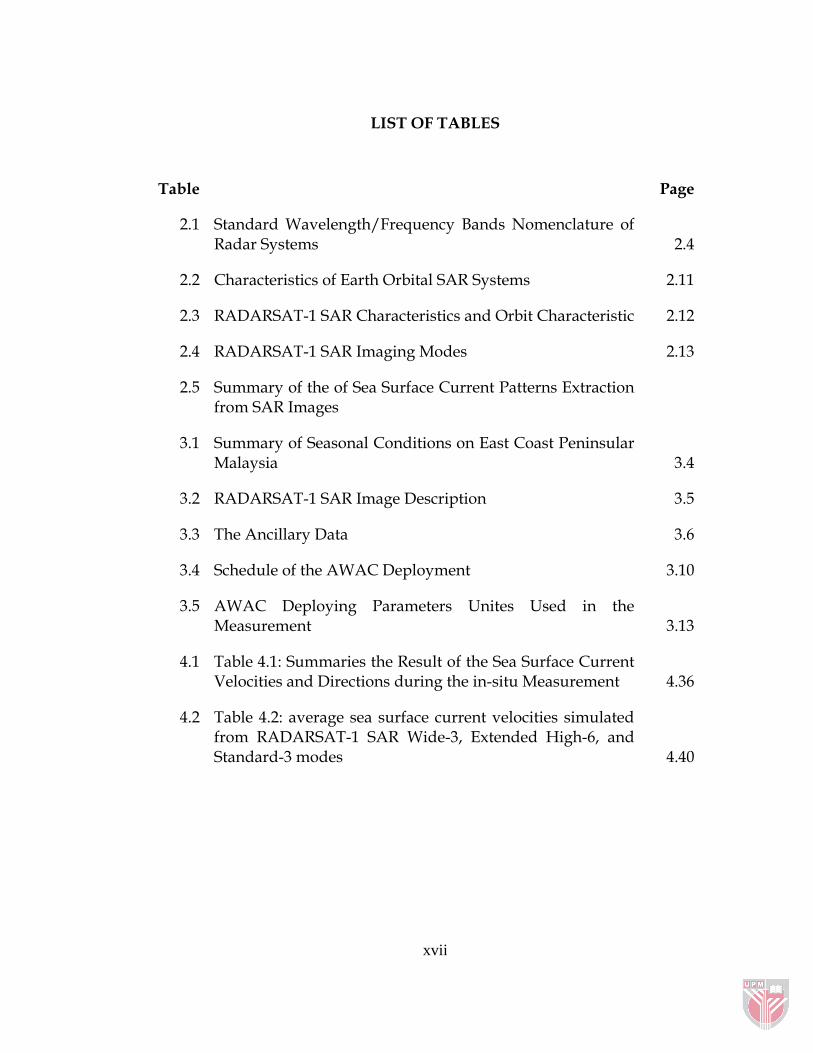
LIST OF TABLES
Table Page
2.1 Standard Wavelength/Frequency Bands Nomenclature of Radar Systems 2.4
2.2 Characteristics of Earth Orbital SAR Systems 2.11
2.3 RADARSAT-1 SAR Characteristics and Orbit Characteristic 2.12
2.4 RADARSAT-1 SAR Imaging Modes 2.13
2.5 Summary of the of Sea Surface Current Patterns Extraction from SAR Images
3.1 Summary of Seasonal Conditions on East Coast Peninsular Malaysia 3.4
3.2 RADARSAT-1 SAR Image Description 3.5
3.3 The Ancillary Data 3.6
3.4 Schedule of the AWAC Deployment 3.10
3.5 AWAC Deploying Parameters Unites Used in the Measurement 3.13
4.1 Table 4.1: Summaries the Result of the Sea Surface Current Velocities and Directions during the in-situ Measurement 4.36
4.2 Table 4.2: average sea surface current velocities simulated from RADARSAT-1 SAR Wide-3, Extended High-6, and Standard-3 modes 4.40

xviii
LIST OF FIGURES
Figure Page
2.1 Electromagnetic Spectrum in the Visible, Near, Middle and Thermal Infrared and the Microwave Regions 2.3
2.2 Schematic Diagrams of System and Local Incident Angle 2.6
2.3 RADARSAT-1 SAR Imaging Modes Acquisition 2.12
2.4 Satellite Altimetry Operation Comparing to SAR Swath 2.17
2.5 Illustration of Bragg Scattering 2.20
2.6 The Observation Geometry in the Velocity Vector and Target Pan 2.26
2.7 Schematic Geometry of the ATI-SAR 2.36
2.8 The Orientation of the Three Slanted Transducers used by the AWAC 2.48
3.1 Study Area Location 3.3
3.2 Deploying the AWAC in the Fieldwork Area 3.11
3.3 A Sketch of AWAC Deploying in the Fieldwork Area 3.12
3.4 Standard-2 Mode Image Shows the Study Area Locations Containing Onshore, Fieldwork, Midshore, and Offshore Areas 3.15
3.5 Flowchart of the Model Analysis 3.16
3.6 The Centeroid Doppler Shift Frequency Process Applied on the Subset Images of the Study Area 3.17

xix
4.1 Sea Surface Current Polar on March 21, 24, and 31, 2005 4.3
4.2 Current Velocity Extracted from AWAC through the Deploying measurement on March 21, 25, and 31, 2005 4.6
4.3 Current Direction Extracted from AWAC through the Deploying measurement on March 21, 25, and 31, 2005 4.8
4.4 The Tide Information on March 21, 25, and 31, 2005 4.10
4.5 Sea surface Current Velocity Simulated from RADARSAT-1 SAR Wide-3, Extended High-6, and Standard-2 Modes in the Onshore Area 4.13
4.6 Sea Surface Current Velocity Simulated from RADARSAT-1 SAR Wide-3, Extended High-6, and Standard-2 Modes in the Fieldwork Area 4.14
4.7 Sea Surface Current Velocity Simulated from RADARSAT-1 SAR Wide-3 and Standard-2 Modes in the Midshore 4.15
4.8 Sea Surface Current Velocity Simulated from RADARSAT-1 SAR Wide-3 and Standard-2 Modes in the Offshore Area
4.16
4.9 Comparison between Physical Properties of RADARSAT-1 SAR Wide-3 Mode and the Bathymetry along the Study Area
4.24
4.10 Comparison between Physical Properties of RADARSAT-1 SAR Extend High-6 Mode and the Bathymetry in the Onshore and Offshore.
4.25
4.11 Comparison between Physical Properties of RADARSAT-1 SAR Standard-2 Mode and the Bathymetry along the Study Area. 4.26
4.12 Doppler Spectral Intensity from Subset Image 512×512 (Wide-3 Mode) in the Onshore 4.30
4.13 Doppler Spectral Intensity from Subset Image 512×512 (Wide-3 Mode) in the Fieldwork 4.30
4.14 Doppler Spectral Intensity from Subset Image 512×512 (Wide-3 Mode) in the Midshore 4.30

xx
4.15 Doppler Spectral Intensity from Subset Image 512×512 (Wide-3 Mode) in the Offshore 4.30
4.16 Doppler Spectral Intensity from Subset Image 512×512 Extended High-6 Mode) in the Onshore 4.31
4.17 Doppler Spectral Intensity from Subset Image 512×512 Extended High-6 Mode) in the Fieldwork Area 4.31
4.18 Doppler Spectral Intensity from Subset Image 512×512 Standard-2 Mode) in the Onshore 4.32
4.19 Doppler Spectral Intensity from Subset Image 512×512 Standard-
2 Mode) in the Fieldwork Area 4.32
4.20 Doppler Spectral Intensity from Subset Image 512×512 Standard-2 Mode) in the Midshore 4.32
4.21 Doppler Spectral Intensity from Subset Image 512×512 Standard-2 Mode) in the Offshore 4.32
4.22 3D visualization of the bathymetry of the study area 4.34
4.23 RADARSAT-1 SAR Wide-3 Mode Cross Section in the Onshore 4.41
4.24 RADARSAT-1 SAR Wide-3 Mode Cross Section in the Offshore 4.41
4.25 RADARSAT-1 SAR Extended High-6 Mode Cross Section in the Onshore 4.42
4.26 RADARSAT-1 SAR Standard-2 Mode Cross Section in the Onshore 4.43
4.27 RADARSAT-1 SAR Standard-2 Mode Cross Section in the Offhore 4.43
4.28 Affection of Physical Properties of RADARSAT-1 SAR Standard-2 mode Backscatter on the Sea Surface Current Patterns 4.44

xxi
4.29 Spectra Intensity of the Study Area Extracted from RADARSAT-1 SAR Wide-3, Extended High-6, and Standard-2 4.48
4.30 Spectral Magnitude of the Doppler Frequency Shift Extracted from the RADARSAT-1 SAR Wide-3 (Onshore) 4.49
4.31 Spectral Magnitude of the Doppler Frequency Shift Extracted from the RADARSAT-1 SAR Wide-3 (Insitu measurement) 4.49
4.32 Spectral Magnitude of the Doppler Frequency Shift Extracted from the RADARSAT-1 SAR Wide-3 (Midshore) 4.50
4.33 Spectral Magnitude of the Doppler Frequency Shift Extracted from the RADARSAT-1 SAR Wide-3 (Offshore) 4.50
4.34
Spectral Magnitude of the Doppler Frequency Shift Extracted from the RADARSAT-1 SAR Extended High-6 (Onshore)
4.51
4.35 Spectral Magnitude of the Doppler Frequency Shift Extracted from the RADARSAT-1 Extended High-6 (Insitu measurement) 4.51
4.36 Spectral Magnitude of the Doppler Frequency Shift Extracted from the RADARSAT-1 Standard-2 (Onshore) 4.52
4.37 Spectral Magnitude of the Doppler Frequency Shift Extracted from the RADARSAT-1 Standard-2 (Insitu measurement) 4.52
4.38 Spectral Magnitude of the Doppler Frequency Shift Extracted from the RADARSAT-1 Standard-2 (Midshore) 4.53
4.39 Spectral Magnitude of the Doppler Frequency Shift Extracted from the RADARSAT-1 Standard-2 (Offshore) measurement) 4.53
4.40 Sea Surface Current Direction Extracted from RADARSAT-1 SAR Image on 21/3/2005 at 6:48 AM 4.61

xxii
4.41 The Grid Map of the Geostrophic Current in the Study East Coast of Kuala Terengganu Collected by TOPEX/POSEIDON Merged Satellite Altimetry on March 21, 2005 4.62
4.42 Wind Direction on March 21, 2005 at 6 AM 4.63
4.43 Average of Wind Speed on March 19 to 22
2005 Extracted from GEOSAT-2 Altimeter 4.63
4.44 Sea Surface Current Direction Extracted from RADARSAT-1 SAR Image on March 25, 2005 at 7:39 AM 4.64
4.45 The Grid Map of the Geostrophic Current in the Study East Coast of Kuala Terengganu Collected by TOPEX/POSEIDON Merged Satellite Altimetry on March 25, 2005 4.65
4.46 Wind Direction on March 25, 2005 at 6 AM 4.66
4.47
Average of Wind Speed on March 23 to 28 2005 Extracted from GEOSAT-2 Altimeter
4.66
4.48 Sea Surface Current Direction Extracted from RADARSAT-1 SAR Image on March 31, 2005 at 6:57 AM 4.67
4.49 The Grid Map of the Geostrophic Current in the Study East Coast of Kuala Terengganu Collected by TOPEX/POSEIDON Merged Satellite Altimetry on March 25 2005 4.68
4.50 Wind Direction on March 31, 2005 4.69
4.51 Average of Wind Speed on March 28, 2005 to April 1 2005 Extracted From GEOSAT-2 Altimeter 4.70
4.52 Correlation between RADARSAT-1 Wide-3 Mode and In-situ Measurement on March 21, 2005 4.75
4.53 Residual Plots for RADARSAT-1 Wide-3 mode 4.76
4.54 Correlation between RADARSAT-1 Extended High-6 Mode 4.76

xxiii
and In-situ Measurement on March 25, 2005
4.55 Residual Plots for RADARSAT-1 Extended High-6 mode 4.76
4.56 Correlation between RADARSAT-1 Standard-2 Mode and In-situ Measurement on March 31, 2005 4.77
4.57 Residual Plots for RADARSAT-1 Standard-2 mode 4.77

xxiv
LIST OF ABBREVIATIONS
b the chirp rate = Rkv /2 2
bT Received signal azimuthal bandwidth
c velocity of light = 3 × 10⁸
ƒ frequency of an electromagnetic wave
maxf Doppler peak frequency shift
xf spatial domain function
DF the change in the received frequency using AWAC
sF frequency of transmitted sound using AWAC
uF frequency domain function
k Radar wave number
1M First target direction
2M Second target direction
R Radar slant range
t Amplitude of the coherent in the image
T Coherent integration time
sT Gaussian function with width
u spatial frequency
V satellite velocity = 6212 m/s
cV horizontal ocean current
rv Radial velocity of a target
0x location of a point target in the SAR image
delay time
Wavelength
Incident angle
Local modification of the incident angle