Embed Size (px)
Citation preview

UNIVERSITI PUTRA MALAYSIA
LAND SUITABILITY FOR RICE GROWING IN THE KLANG VALLEY USING GEOGRAPHICAL INFORMATION SYSTEM AND ANALYTICAL
HIERARCHY PROCESS FOR URBAN FOOD SECURITY
SHAMSUL B. ABU BAKAR
FRSB 2007 2

LAND SUITABILITY FOR RICE GROWING IN THE KLANG VALLEY
USING GEOGRAPHICAL INFORMATION SYSTEM AND ANALYTICAL
HIERARCHY PROCESS FOR URBAN FOOD SECURITY
By
SHAMSUL B. ABU BAKAR
Thesis Submitted to the School of Graduate Studies, Universiti Putra Malaysia,
in Fulfilment of the Requirements for the Degree of Master of Science
September 2007

ii
DEDICATION
To my parents, Abu Bakar Md Sap and Siti Zabedah Embi this thesis is dedicated to
both of you. My beloved wife, Noora Shafei and son, Muhammad Nabeel Aiman,
both of you are my greatest encouragement. Deepest thanks to my supervisors,
Professor Dr Mustafa Kamal Mohd Shariff, Associate Professor Dr Ahmad Rodzi
Mahmud and Dr Siva K. Balasundram for all the valuable guidance’s and supports.

iii
Abstract of thesis presented to the Senate of Universiti Putra Malaysia in fulfilment of
the requirement for the degree of Master of Science
LAND SUITABILITY FOR RICE GROWING IN THE KLANG VALLEY
USING GEOGRAPHICAL INFORMATION SYSTEM AND ANALYTICAL
HIERARCHY PROCESS FOR URBAN FOOD SECURITY
By
SHAMSUL ABU BAKAR
September 2007
Chairman: Professor Mustafa Kamal Mohd Shariff, PhD
Faculty: Design and Architecture
Klang Valley is the most rapidly growing region in terms of physical and economic
development in Malaysia. It has a population of 4.07 million people, accounting for
nearly 17.5 % of the total national population. Thus, a large amount of constant food
supply is required to meet the population’s demand. However, the current situation is
that Klang Valley is heavily dependent on external sources of food supply. In the
event of emergencies such as natural or man-made disasters, Klang Valley will face a
high risk of disruption in food supply. The aim of this study is to identify and analyze
potential rice cultivation areas as urban food reservoir within the highly urbanized
Klang Valley.

iv
By using Geographical Information System (GIS) and Analytical Hierarchy Process
(AHP), a land suitability analysis for rice cultivation was carried out in this study
area. To construct a rice suitability model, expert evaluation on criteria such as soil
series, rainfall, topography, groundwater and strategic agriculture distances were
evaluated based on weightage ranking. Those weightage were obtained by using a
Pairwise Comparison Method and then converted into spatial values using ArcGIS 9
weighted overlay process.
Results indicated several areas within the Klang Valley having strategic potentials for
rice growing. These areas are classified into three major classes - highly suitable,
suitable and moderately suitable. The percentage of highly suitable area is 3504.35 ha
(8.82 %), suitable areas 18793.28 ha (47.34 %) and moderately suitable areas
17403.02 ha (43.84%). The total areas suitable for rice growing is 39700.65 ha (14%)
from the total size of Klang Valley.

v
Abstrak tesis yang dikemukakan kepada Senat Universiti Putra Malaysia sebagai
memenuhi keperluan untuk ijazah Master Sains
KESESUAIAN TANAH UNTUK PENANAMAN PADI DI LEMBAH KLANG
MENGGUNAKAN SISTEM MAKLUMAT GEOGRAFI DAN PROSES
ANALATIKAL HIERAKI UNTUK KESELAMATAN MAKANAN BANDAR
Oleh
SHAMSUL ABU BAKAR
September 2007
Pengerusi: Profesor Mustafa Kamal Mohd Sharif, PhD
Fakulti: Rekabentuk dan Senibina
Lembah Klang adalah merupakan kawasan perbandaran yang paling membangun dari
segi fizikal dan juga ekonomi di Malaysia. Ia mempunyai populasi lebih dari 4.07
juta, iaitu 17.5% dari jumlah keseluruhan penduduk nasional. Oleh itu, keperluan
makanan yang berterusan adalah amat diperlukan untuk memenuhi keperluan dan
permintaan penduduk. Walaubagaimanapun, pada masa sekarang Lembah Klang
amat bergantung dengan bekalan makanan yang dihasilkan di luar kawasan sempadan.
Sekiranya berlaku kecemasan samada bencana alam ataupun akibat dari aktiviti
manusia, Lembah Klang akan mengalami risiko utama kekurangan bekalan makanan
yang amat tinggi. Tujuan kajian ini dilakukan adalah untuk menganalisis dan
mengenalpasti kawasan yang sesuai untuk penanaman padi supaya ianya boleh
dijadikan sebagai ‘empangan’ makanan di sekitar kawasan perbandaran di Lembah
Klang

vi
Dengan mengunakan Sistem Maklumat Geografi dan juga Proses Analatikal Hieraki,
analisis kesesuaian tanah untuk penanaman padi telah dilakukan di kawasan ini.
Untuk membina model kesesuian, penilaian pakar terhadap siri tanah, hujan,
topografi, air bawah tanah dan kedudukan strategik kawasan pertanian dilakukan
menggunakan kaedah pemberat. Pemberat kriteria ini didapati melalui Kaedah
Perbandingan ‘Pairwise’ dan kemudianya diubah kepada nilai spatial menggunakan
perisian Proses Pemberatan Lapisan ArcGis 9.
Keputusan menunjukan bahawa terdapat beberapa kawasan di Lembah Klang yang di
kenal pasti mempunyai potensi strategik sebagai kawasan penanaman padi. Kawasan
ini dibahagikan kepada tiga bahagian yang utama - ‘paling sesuai’, ‘sesuai’ dan
‘sedikit sesuai’. Peratusan keseluruhan keluasan untuk kawasan yang ‘paling sesuai’
adalah sebanyak 8.82% (3504.35 ha.), ‘sesuai’ sebanyak 47.34% (18793.28 ha.) dan
‘sedikit sesuai’ sebanyak 43.84% (17403.02 ha.). Jumlah keseluruhan kawasan yang
sesuai untuk penanaman padi ini adalah 39700 ha. iaitu 14% dari jumlah keluasan
kawasan yang terdapat di Lembah Klang.

vii
ACKNOWLEDGEMENTS
First and foremost, I thank Allah Almighty for His blessing that gave me courage to
explore and gain knowledge. My deepest gratitude goes to my supervisor, Prof. Dr.
Mustafa Kamal Mohd Shariff for his friendship, faith and guidance that inspired me
throughout the research. To my co-supervisor, Assoc. Prof. Dr. Ahmad Rodzi
Mahmud and Dr Siva K. Balasundram, thank you for your commitment, support and
understanding throughout the preparation of the thesis. Without both of your precious
views and opinions this study may not have been completed.
I would also like to take this opportunity to thank Mr. Nor Sallehi Kassim, Assistant
Director of National Physical Plan Division (JPBD) and Tn. Haji Alias Ismail,
Assistant Director of Paddy Division (MARDI), Assoc. Prof Syed Omar Syed Rastan,
Deputy Dean, Faculty of Agriculture, Tn. Haji Muhamad Harun, Station Manager for
MARDI Tanjong Karang, Dr Sariam Othman, MARDI Seberang Prai for all the
cooperation given to complete the research. Their willingness to spend their valuable
time towards the research progress is most appreciated.
To my research colleque, Nisfariza Mohd Noor Maris and Mohd Hazley Abdul Halim
thanks for all the support and help that I gain during our discussions. I may not be
able to repay both of your kindness. Last but not least, I would like to thank
everybody who contributes towards the completion of the research.

viii
I certify that an Examination Committee has met on 4th
September 2007 to conduct
the final examination of Shamsul bin Abu Bakar on his Master of Science thesis
entitled “Land Suitability for Rice Growing in the Klang Valley Using Geographical
Information System and Analytical Hierarchy Process for Urban Food Security” in
accordance with Universiti Pertanian Malaysia (Higher Degree) Act 1980 and
Universiti Pertanian Malaysia (Higher Degree) Regulations 1981. The Committee
recommends that the candidate be awarded the degree of Master of Science.
Members of the Examination Committee were as follows:
Rahinah Ibrahim, PhD Associate Professor
Faculty of Design and Architecture
Universiti Putra Malaysia
(Chairman)
Kamariah Dola, PhD
Lecturer
Faculty of Design and Architecture
Universiti Putra Malaysia
(Internal Examiner)
Helmi Zuhaidi Mohd Safri, PhD
Lecturer
Faculty of Engineering
Universiti Putra Malaysia
(Internal Examiner)
Hadi Susilo Arifin, PhD Professor
Faculty of Agriculture
Bogor Agriculture University
(External Examiner)
________________________________
HASANAH MOHD GHAZALI, PhD Professor and Deputy Dean
School of Graduate Studies
Universiti Putra Malaysia
Date : 17 December 2007

ix
This thesis was submitted to the Senate of Universiti Putra Malaysia and has been
accepted as fulfilment of the requirement for the degree of Master of Science. The
members of the Supervisory Committee were as follows:
Mustafa Kamal Mohd Shariff, PhD
Professor
Faculty of Design and Architecture
Universiti Putra Malaysia
(Chairman)
Ahmad Rodzi Mahmud, PhD
Associate Professor
Faculty of Engineering
Universiti Putra Malaysia
(Member)
Siva K. Balasundram, PhD
Lecturer
Faculty of Agriculture
Universiti Putra Malaysia
(Member)
________________________
AINI IDERIS, PhD
Professor and Dean
School of Graduate Studies
Universiti Putra Malaysia
Date: 22 January 2008

x
DECLARATION
I hereby declare that the thesis is based on my original work except for quotations and
citations in which have been duly acknowledged. I also declare that it has not been
previously or concurrently submitted for any other degree at UPM or other
institutions.
______________________
SHAMSUL ABU BAKAR
Date:
xi
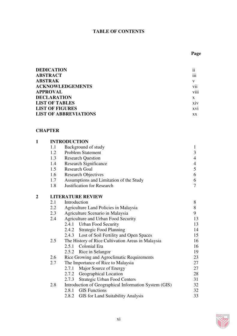
TABLE OF CONTENTS
Page
DEDICATION ii
ABSTRACT iii
ABSTRAK v
ACKNOWLEDGEMENTS vii
APPROVAL viii
DECLARATION x
LIST OF TABLES xiv
LIST OF FIGURES xvi
LIST OF ABBREVIATIONS xx
CHAPTER
1 INTRODUCTION
1.1 Background of study 1
1.2 Problem Statement 3
1.3 Research Question 4
1.4 Research Significance 4
1.5 Research Goal 5
1.6 Research Objectives 6
1.7 Assumptions and Limitation of the Study 6
1.8 Justification for Research 7
2 LITERATURE REVIEW
2.1 Introduction 8
2.2 Agriculture Land Policies in Malaysia 8
2.3 Agriculture Scenario in Malaysia 9
2.4 Agriculture and Urban Food Security 13
2.4.1 Urban Food Security 13
2.4.2 Strategic Food Planning 14
2.4.3 Lost of Soil Fertility and Open Spaces 15
2.5 The History of Rice Cultivation Areas in Malaysia 16
2.5.1 Colonial Era 16
2.5.2 Rice in Selangor 19
2.6 Rice Growing and Agroclimatic Requirements 23
2.7 The Importance of Rice to Malaysia 27
2.7.1 Major Source of Energy 27
2.7.2 Geographical Location 28
2.7.3 Strategic Urban Food Centers 31
2.8 Introduction of Geographical Information System (GIS) 32
2.8.1 GIS Functions 32
2.8.2 GIS for Land Suitability Analysis 33

xii
2.8.3 GIS in Planning of Agriculture Area 35
2.8.4 Multi Criteria Decision Making (MCDM) 37
2.9 Summary of the Review 43
3 METHODOLOGY
3.1 Introduction 44
3.2 Stage 1-Procedure Design 44
3.2.1 Data Acquisition and Criteria Selection 44
3.2.2 Data Input 45
3.2.3 Database Construction in Thematic Layer 46
3.3 Stage 2-Data Analysis 46
3.3.1 Overlay Process 46
3.3.2 Clipping 47
3.3.3 Buffering 47
3.3.4 Data Conversion 48
3.3.5 Reclassification 48
3.3.6 Assigning Criterion Weightage 48
3.3.7 Weightage Standardization 48
3.4 Stage 3-Data Evaluation and Communication 49
3.5 Study Area 50
3.6 Summary 55
4 RESULTS AND DISCUSSIONS 4.1 Introduction 56
4.2 Identification of Rice Cultivation Suitability Criteria 57
4.2.1 Terrain /Topography 57
4.2.2 Rainfall 58
4.2.3 Soil Series 59
4.2.4 Ground Water 62
4.2.5 Strategic Agriculture Area 63
4.3 Database Construction for Rice Cultivation Suitability Area 64
4.3.1 Construction of Terrain Theme Layer 64
4.3.2 Construction of Rainfall Theme Layer 66
4.3.3 Construction of Soil Theme Layer. 71
4.3.4 Construction of Ground Water Theme Layer 74
4.3.5 Construction of Strategic Agriculture Land Use
Theme Layer 75
4.4 Criteria Weightage Evaluation Using AHP 80
4.4.1 Overall Criteria Weightage Evaluation 81
4.4.2 Weightage Evaluation for Sub-Criteria 82
4.4.2.1 Terrain Comparison 82
4.4.2.2 Rainfall Comparison 83
4.4.2.3 Soil Series Comparison 84
4.4.2.4 Strategic Agriculture Land Use Comparison 85
4.4.2.5 Groundwater Comparison 86

xiii
4.4.3 Overall Hierarchy Weightage 88
4.4.4 Weightage Comparison among Sub-Criteria 89
4.4.5 Weightage Percentage 90
4.4.6 Weightage Performance 91
4.5 Land Suitability Process 92
4.5.1 Standardize and Normalize Value 92
4.5.2 Data Conversion and Reclassification 95
4.5.2.1 Terrain Conversion and Reclassification 96
4.5.2.2 Rainfall Conversion and Reclassification 97
4.5.2.3 Soil Series Conversion and Reclassification 98
4.5.2.4 Strategic Agriculture Land Use Conversion and
Reclassification 99
4.5.2.5 Groundwater Conversion and Reclassification 100
4.5.3 Weighted Overlay Analysis 101
4.5.4 Reclassify Raster Suitability Value 103
4.6 Suitability results 106
4.6.1 Total Suitability Area in Klang Valley 106
4.6.2 Suitability Results According to District in Klang Valley 107
4.7 Ground Truthing Process 108
4.8 Summary 116
5 CONCLUSIONS AND RECOMMENDATIONS
5.1 Introduction 117
5.2 Summary of Finding 117
5.4 Recommendations for Future Research 119
REFERENCES 122
APPENDICES 127
BIODATA OF THE AUTHOR 140
LIST OF PUBLICATIONS 141

xiv
LIST OF TABLES
Table Page
2.1 Agriculture Land Use (hectares) 1995-2005 9
2.2 Agriculture Production (000 tonnes 1995-2005) 10
2.3 Export and Imports of Food ( RM million), 1995-2005 11
2.4 Malaysia Imports on Rice 12
2.5 Rice Hectares in Selangor (Year 1995-1996) 21
2.6 Selangor Rice Production (Year 2001) 23
2.7 Requirement for Wetland Rice According to Loh (1997) 24
2.8 Requirement for Wetland Rice According to Mongklosawat, et al. (1997). 25
2.9 Requirement for Wetland Rice According to Syartinilia, et al. (2004). 26
2.10 Agroclimatic Requirements for Rice field by DOA 27
2.11 Scale of Pairwise Comparison 41
2.12 An Example of Pairwise Comparison Matrix 41
3.1 Population Change in Klang Valley 54
4.1 Criteria and Sub-criteria Selection for Terrain 58
4.2 Criteria and Sub-criteria Selection for Rainfall 59
4.3 Criteria and Sub-criteria Selection for Soil Series 60
4.4 Average Criteria and Sub-criteria Selection for Soil Group 61
4.5 Criteria and Sub-criteria Selection for Ground water 62
4.6 Criteria and Sub-criteria Selection for Strategic Agriculture Area. 63
4.7 Rainfall Volume for 26 Observation Points in Selangor 67
4.8 Criteria Relative Importance With Respect to Goal 81

xv
4.9 Compare the Relative Importance With Respect to : Climatic/rainfall 83
4.10 Compare the Relative Importance With Respect to : Soils Series 84
4.11 Compare Relative Importance With Respect to: Strategic Land Use 86
4.12 Compare the Relative Importance With Respect to : Ground water 87
4.13 Normalized Value by Using LTS 93
4.14 Sub-criteria Spatial Value for Weighted Overlay Analysis 94
4.15 Old Raster Value and New Raster Value 95
4.16 Total Suitability Area 106
4.17 Suitability Class According to District 107
4.18 Suitability Percentage According to District Total Suitability Area 107
4.19 Suitability Class Percentage According to District 107
4.20 Random GPS Points for Ground Thruthing Process. 109

xvi
LIST OF FIGURES
Figure Page
2.1 Urbanize Area Versus Open Spaces in Klang Valley 16
2.2 Rice Areas in Malaya According to Jack (1923) 18
2.3 Rice Growing in Coastal Selangor and the Tin Zone (1900) 20
2.4 Selangor Rice Distribution 22
2.5 An Example of Paddy Cultivation Area in IADP Pulau Pinang 29
2.6 An Example of Paddy Cultivation in MUDA Granary Area 30
2.7 An Example of Paddy Cultivation in IADP Kerian-Sungai Manik 30
2.8 Some of Destroyed Paddy Area in Aceh Province after 2004 Tsunami 31
2.9 Structure of GIS 33
2.10 Analytical Hierarchy Process (AHP) Procedure 39
2.11 GIS Based Rating of Alternatives 39
2.12 Computation of the Criterion Weight 42
2.13 Estimation of the Consistency Ratio 42
3.1 Research Stages 44
3.2 Magellan (GPS) Handheld Meridian Platinum Series Model 50
3.3 Research Methodology Framework 51
3.4 Map of Peninsular Malaysia 52
3.5 District within Klang Valley 53
4.1 Flow of Research Analysis 56
4.2 Map of Slope Area within Klang Valley 64
4.3 Extract Slope Class by Using Model Builder 64

xvii
4.4 SQL Language for Slope Class Selection in Query Builder 65
4.5 Result on Slope Class Using Select Tool in the Model Builder 65
4.6 Five Years Average Rainfall Graph. 66
4.7 Projection of Selangor Rainfall Observation Points 68
4.8 Kriging Interpolation Analysis for Rainfall Distribution in Raster Format 69
4.9 Selangor Rainfall Conversion from Raster to Polygon 70
4.10 Rainfall Distributions Clipped with Klang Valley Boundary 70
4.11 Map of Rainfall Distribution in Klang Valley 71
4.12 Klang Valley Soil Series Map. 72
4.13 Execution of Soil Group Selection in Model Builder 72
4.14 SQL Language for Soil Group Selection in Query Builder 73
4.15 Result on Soil Selection Using Select Tool in the Model Builder 73
4.16 Selangor Groundwater Map Clipped with Klang Valley Boundary Area. 74
4.17 Map of Ground water Distribution in Klang Valley 75
4.18 Selangor Agriculture Map Clipped with Klang Valley Boundary Area. 76
4.19 Klang Valley Agriculture Map 76
4.20 Selangor Urban Distribution Clipped with Klang Valley Boundary 77
4.21 Klang Valley Major Urban Area 77
4.22 Buffer Distance into the ‘Multiple Ring Buffer’ 78
4.23 Selangor Urban Buffer Zone Clipped with Agriculture Area 78
4.24 Results of Strategic Agriculture Distance in Klang Valley 79
4.25 Structured Criteria in Hierarchical Level 80
4.26 Synthesis of Criteria Relative Importance With Respect to Goal 82
4.27 Synthesis with Respect to : Climatic / Rainfall 84
4.28 Priorities with Respect to : Soil Series 85

xviii
4.29 Synthesis with Respect to : Strategic Land Use 86
4.30 Synthesis with Respect to : Ground water 87
4.31 Overall Hierarchy Weightage with Respect to Goal 88
4.32 Overall Synthesis with Respect to Goal 90
4.33 Dynamic Sensitivity Analysis to Goal 91
4.34 Performance Sensitivity with Respect to Goal 91
4.35 Vector to Raster Conversion for Terrain 96
4.36 Reclassify Value for Terrain 96
4.37 ArcGIS Model Builder for Terrain 96
4.38 Vector to Raster Conversion for Rainfall 97
4.39 Reclassify Value for Rainfall 97
4.40 ArcGIS Model Builder for Rainfall 97
4.41 Vector to Raster Conversion for Soil Series 98
4.42 Reclassify Value for Soil Series 98
4.43 ArcGIS Model Builder for Soil Series 98
4.44 Vector to Raster Conversion for Agriculture Land Use 99
4.45 Reclassify Value for Agriculture Land Use 99
4.46 ArcGIS Model Builder for Agriculture Land Use 99
4.47 Vector to Raster Conversion for Ground Water 100
4.48 Reclassify Value for Ground Water 100
4.49 ArcGIS Model Builder for Ground Water 100
4.50 Weighted Overlay Model Builder 101
4.51 Weighted Overlay Table 102
4.52 Raster Value for Suitability Map 103
4.53 Layer Properties Classification 104

xix
4.54 Classification Method 104
4.55 Suitability Map for Rice Cultivation in Klang Valley 105
4.56 Distribution Graph for Suitability Area. 106
4.57 Suitability Distribution within District in Klang Valley 108
4.58 GPS Points Distribution in Suitability Map. 110
4.59 Site Description According to GPS Point Images. 113
4.60 Suitable Areas Converted into Other Types of Land Use. 113
4.61 Totally Not Suitable Areas According to Suitability Map 114
4.62 Overlaid Satellite Image 115

xx
LIST OF ABBREVIATIONS
AHP Analytical Hierarchy Process
CR Consistency Ratio
DOA Department of Agriculture
DID Department of Irrigation and Drainage
MMD Malaysian Meteorological Deparment
FAO Food and Agriculture Organization
FAOSTAT Food and Agriculture Organization Statistis
GIS Geographical Information System
GPS Global Positioning System
GDP Gross Domestic Products
IADP Integrated Agricultural Development Project
IRRI International Rice Research Institute
KADA Kemubu Agricultural Development Authority
LUPAS Land Use Planning and Analysis System
LST Linear Scale Transformation
MADA Muda Agricultural Development Authority
MARDI Malaysia Agricultural Research and Development Institute
MCDM Multi Criteria Decision Analysis
MADM Multi Attribute Decision Making
MCDA Multi Criteria Decision Analysis
MODM Multi Objective Decision Making
NPP National Physical Plan

xxi
NAI Nutrient Availability Index
NAP3 Third National Agricultural Policy
PCM Pairwise Comparison Methods
PA Precision Agriculture
PAA Prime Agricultural Areas
RS Remote Sensing
WLC Weighted Linear Combination

CHAPTER 1
INTRODUCTION
1.1 Background of Study
The process of urban expansion or urban sprawl towards land uses have become one
of the major issues for concern in the world. Urban areas are known as the centers of
all activities including commerce, industry, settlement, culture and institutional uses.
Urban areas continue to expand in size and taking over land for other uses, mainly
agriculture areas (Fazal, 2001). According to Brabec and Smith (2002) urban sprawl
is caused mainly by the continued out migration of residents from city centers into
relatively inexpensive and lower density land housing in the urban fringes. This
phenomenon has already placed a tremendous pressure on farmland resources. To
meet the needs of the increasing urban population, land within urban periphery and
rural areas are currently being converted into housing, shopping and retail, civic
institution, business park and roadways.
Rapid encroachment by urban development causes tremendous lost of open spaces,
green areas and also give impacts to the surrounding environment such as pollution
and climate changes. The speed of urban growth and “land-use change” raised many
problems such as inadequate infrastructure, increased population and employment
pressure, overcrowding, slum communities arising from low-income groups, food
insecurity and environmental degradation (Thapa et al, 2004).

2
Urban sprawl is often perceived as a negative urban phenomenon with costs including
un-sightly development as well impacts on social and economics values. In most
cases, agriculture land and rural areas located within urban periphery are facing
greater loss in term of land use conversion into non-agricultural uses. Brabec and
Smith (2002) added that the scenario of agriculture fragmentations in the urban fringe
not only contribute to the loss of traditional farming economic base but also to the
character and visual quality of the rural communities. Fragmentation of agricultural
land by urban sprawl also affects not only the agricultural production capacity of the
land but also its rural scenic quality.
The decline land suitable for agriculture not only affect the production of commercial
crops such as rubber and oil palm but also the production of the food commodities
such as rice, vegetables and fruits that are vital for high populated urban areas.
According to Kuminoff et al., (2000) large-scale farmland conversions that reduce the
production of certain commodities could affect local and even international food
market. Argenti (2000) added that continous urban growth will contribute greater
implications for future urban food security. This issues was raised in the State of
California, United States where it produce most of its own food and would faces
shortage if its existing farmland were to be developed for urban use. Based on the
arguments, it is necessary for urban areas to have a sufficient amount of land that can
be use as food crop production areas. In the event of emergencies such as natural
disasters and wars, every community should be able to produce or supply at least a
third of the food required by its residents (Mann, 2003).

3
The Malaysian National Physical Plan (2005) specified that assessment of land for
urban uses require the consideration of two factors. First, demand for land generated
by the increase in urban population and secondly an assessment of lands that could
made available for urban uses without jeopardizing the integrity of key land uses
considered essential as food supply, agricultural production purposes or which are
subject to environmental constraints.
1.2 Problem Statement
Klang Valley is the most rapidly growing region in terms of physical and economical
development in Malaysia. It has a population of 4.07 million, accounting to nearly
17.5 % of the total national population and is still growing at a rate of 2.4% annually.
To sustain such a large population, Government has to fulfill demands for
infrastructure and other physical development that would involve tremendous new
land usage. Such physical development contributes to urban sprawl. In most cases, the
process of urban sprawl causes losses towards other land uses especially land for
agriculture. The intrusion of urban land uses into agriculture land or potentially
suitable agriculture land creates agriculture land fragmentations. Planners and the
relevant authorities often fail to see the importance of agriculture land as a crucial
medium for raw and fresh food production within the urban periphery. Ironically,
urban centers are wholly dependent on outsourced food consumption. With rice as a
staple food item that feeds the Malaysian populations, land suitability analysis for rice
cultivation is becoming essential for Klang Valley. This knowledge will contribute
towards increasing Klang Valley’s food security in time of war and natural disasters.