Embed Size (px)
Citation preview
MEMBER REPORT
ESCAP/WMO Typhoon Committee
42nd
Session
25 – 29 January 2010
Singapore
United States of America
_______________________________________
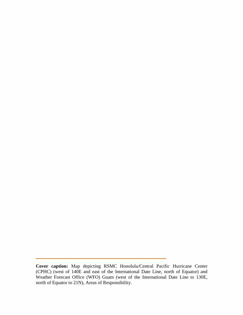
Cover caption: Map depicting RSMC Honolulu/Central Pacific Hurricane Center
(CPHC) (west of 140E and east of the International Date Line, north of Equator) and
Weather Forecast Office (WFO) Guam (west of the International Date Line to 130E,
north of Equator to 21N), Areas of Responsibility.

CONTENTS
I. Overview of tropical cyclones which have affected/impacted Member’s area
since the last Typhoon Committee Session
II. Summary of progress in Key Result Areas
1. Progress on Key Result Area 1 2. Progress on Key Result Area 2 3. Progress on Key Result Area 3 4. Progress on Key Result Area 4 5. Progress on Key Result Area 5 6. Progress on Key Result Area 6 7. Progress on Key Result Area 7
III. Resource Mobilization Activities
IV. Update of Members’ Working Groups representatives
I. Overview of tropical cyclones which have affected/impacted Member’s area
in 2009
Western North Pacific Overview
1. Meteorological Assessment (highlighting forecasting issues/impacts)
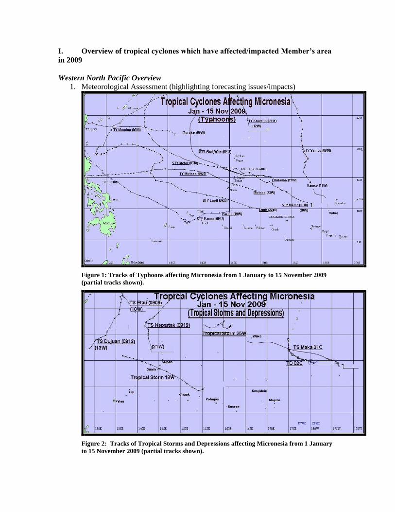
Figure 1: Tracks of Typhoons affecting Micronesia from 1 January to 15 November 2009
(partial tracks shown).
Figure 2: Tracks of Tropical Storms and Depressions affecting Micronesia from 1 January
to 15 November 2009 (partial tracks shown).
Tropical Cyclone activity in the Micronesian portion (area between the Equator
and 21N from 130E to 180, not including Kiribati) of the western North Pacific
from 1 January 2009 through 15 November 2009 was near the norm of 18 to 20
tropical cyclones per year for this region. A total of 13 cyclones originated in this
region and two crossed over from the Central Pacific (see Figure 1). An early-
season La Nina pattern gave way to an El Nino pattern by late summer. This
shifted most tropical cyclone development from western Micronesia to more
eastern regions. This subjected Micronesian locations to a longer duration of
tropical cyclone tracks and to stronger tropical cyclones. Sustained winds
referenced in this report are 1-minute averaged winds.
Typhoon Morakot (09W) developed southeast of Okinawa and 815 miles
northwest of Guam on 4 August. Morakot moved westward out of the Guam
Area of Responsibility (AOR) as a tropical storm on 6 August without affecting
any Micronesian islands or atolls in the region.
A few days later, Tropical Storm Etau (10W) formed northwest of the Marianas
or about 710 miles north-northwest of Guam. Etau moved northwest quickly and
exited the Guam AOR before reaching tropical storm intensity.
Tropical Storm Maka (01C) originated in the Central Pacific on 10 August and
weakened. After crossing the International Date Line, it regenerated northeast of
the Republic of the Marshall Islands (RMI) or about 500 miles north-northeast of
Majuro, RMI on 15 August. Maka took a north-northwestward track and
eventually dissipated about 365 miles southeast of Wake Island.
Typhoon Vamco (11W) developed 1050 miles east-southeast of Guam on 16
August and took a west-northwest track. It intensified into a tropical storm in 24
hours and then into a typhoon the following day. Vamco peaked at 105 KT but
kept on a path that did not affect any of the Micronesian Islands. Vamco exited
the Guam AOR on 22 August.
Typhoon Krovanh (12W) formed northeast of the Marianas chain on 28 August or
about 655 miles north-northeast of Guam in a location not affecting any of the
Micronesian islands. Krovanh left the AOR as a tropical storm a few days later.
Tropical Depression Two-C crossed the International Date Line from the Central
Pacific Ocean basin on 6 August. It continued to move westward, well north of
the RMI and dissipated within 24 hours.
Tropical Storm Dujuan (13W) developed west-northwest of Guam on 4
September and moved north-northeast out of the AOR, not affecting any
Micronesian islands.

Super Typhoon Choi-wan (15W) started around 500 miles east of the Mariana
Islands on 12 September. This particular system caused major concerns for the
Marianas as forecasts predicted typhoon strength winds and a track towards the
island chain, mainly Saipan, Commonwealth of the Northern Marianas (CNMI).
Tropical Storm Watches and Warnings were issued for Guam and for Rota,
CNMI, and Typhoon Watches and Warnings were issued for Tinian, Saipan, and
the northern islands of Agrihan, Pagan and Alamagan in the CNMI. By the
afternoon of 13 September, Choi-wan’s forecast track posed a greater threat to the
northern CNMI islands of Agrihan, Pagan and Alamagan than to Saipan and
Tinian. Choi-wan intensified further, becoming a typhoon and then a super
typhoon as it passed over the island of Alamagan. Severe typhoon conditions
pelted that island for nearly 12 hours. Because of the remoteness of the island,
Navy helicopters were dispatched after the typhoon’s passage to evacuate a
family of six, including a newborn, to the Saipan hospital. The Navy also
delivered food, water and supplies to the remaining residents. After high seas
abated, a chartered vessel was sent to Alamagan to evacuate the remaining 8
residents.
Figure 3: Devastation of Alamagan. Note the twisted crowns of the coconut palms.
Tropical Storm 18W developed 900 miles east-southeast of Guam on 27
September. With Choi-wan still fresh in the minds of the public, all eyes were on
18W, which remained a tropical depression for two days and then was upgraded
to tropical storm when it was only one day away. A Tropical Storm Warning was
issued for Guam and Rota. Forecasts called for minimal tropical storm-strength
winds as 18W approached Guam. However, 18W weakened and quickly
dissipated northeast of Guam. No significant damage was recorded.
Super Typhoon Parma (19W) developed south of the Marianas during the same
time period as tropical cyclones 18W and 20W. Parma was forecast to move
westward through Yap State in the Federated States of Micronesia (FSM).
Tropical Storm Watches and Warnings were issued for the various islands and
atolls in its path. Parma reached tropical storm intensity on 29 September and
became a typhoon near Ngulu Atoll in Yap State, FSM on 30 September. It then
continued to track northwest toward the Philippines and out of the AOR.
Super Typhoon Melor (20W) formed north of Pohnpei, FSM on 29 September. It
was forecast to move towards the Marianas within two days, and therefore,
Watches and Warnings were issued for Guam, Rota, Tinian and Saipan. Melor
passed 90 miles northeast of Saipan, near the uninhabited volcanic island of
Anatahan, with 120 KT sustained winds. The peak wind recorded on Rota was 40
KT and on Saipan was 42 KT. WFO Guam conducted a wind assessment on
Saipan, which revealed that winds on the exposed northwest coastal areas of
Saipan experienced winds that were near typhoon–force. Melor moved out of the
AOR on 6 October.
Tropical Storm Nepartak (21W) formed west of the Marianas on 8 October and
moved northward and then northeastward, exiting the AOR by 12 October. No
island in Micronesia was affected.
Super Typhoon Lupit (22W) was the next threat to the Marianas. Lupit formed
north of Chuuk, FSM or about 560 miles east-southeast of Guam and moved
westward. Although expected to stay south of Guam, tropical storm-force winds
likely extended north into Guam coastal and offshore waters. Tropical Storm
Watches were issued on 14 October. Peak wind recorded on Guam was 53 KT.
Lupit continued moving westward passing between northern Yap State islands
and the Marianas. Typhoon intensity was reached on the evening of 16 October.
Lupit peaked at super typhoon intensity (130 KT) two days later, after passing the
Marianas. It continued its movement out of the AOR and towards the Philippines.
Typhoon Mirinae (23W) developed east-southeast of the Marianas on 26 October.
As a tropical storm, Mirinae maintained a steady track towards Guam, Rota,
Tinian and Saipan. It passed just north of Rota as a minimal tropical storm. Peak
wind on Rota was 54 KT. Mirinae reached typhoon strength on 28 October and
continued westward toward the Philippines.
Tropical Storm 25W developed northeast of the Marianas on 7 November, posing
no threat to any islands in Micronesia. It moved northeast and dissipated on 9
November.

Central Pacific Overview
Figure 4: Tracks of Tropical Cyclones affecting the Central North Pacific
1. Meteorological Assessment (highlighting forecasting issues/impacts)
Developing El Nino conditions across the equatorial Pacific Ocean in 2009
translated into above normal tropical cyclone activity in the Central North Pacific.
From 1 January 2009 through 31 October 2009, and with one month left in the
tropical cyclone season, seven tropical cyclones formed within or moved into the
Central North Pacific. An active MJO (Madden Julian Oscillation) phase
contributed to five tropical cyclones around the month of August, which is
typically the most active month as well. The normal for the basin is four to five
tropical cyclones each year.
Tropical Storm Lana kicked off the 2009 tropical cyclone season for Regional
Specialized Meteorological Center (RSMC) Honolulu on 31 July. Lana started
out as a tropical depression nearly 1200 miles southeast of Hawaii and quickly
intensified to its peak intensity of 55 KT. Lana passed safely to the south of
Hawaii before dissipating into a remnant low on 4 August.
Hurricane Felicia formed in the Eastern Pacific on 3 August and moved into the
Central North Pacific on 8 August. For the next few days…the entire State of
Hawaii watched anxiously as tropical storm watches were issued and Felicia
continued on a westward track aimed directly at the islands. Both low and high
altitude reconnaissance aircraft (Air Force Reserve WC-130 and NOAA Gulf
Stream) flew multiple missions and provided critical information to RSMC

Honolulu forecasters. As forecast, wind shear and cool SSTs eventually took
their toll and Felicia weakened into a remnant low just east of Hawaii.
Maka was a short lived tropical cyclone which formed near the date line on 10
August. Maka spun up into a minimal tropical storm on 11 August and just as
quickly spun down into a remnant low on 12 August.
Hurricane Guillermo formed in the Eastern Pacific on 12 August and entered the
Central North Pacific on 16 August. Guillermo took an unusual track north of the
Hawaiian Islands. At its closest point of approach…Guillermo passed several
hundred miles northeast of Hawaii. Guillermo dissipated over 700 miles north of
Hawaii on 19 August. There were no significant wind or rain impacts. Swell
generated by Guillermo produced advisory level surf across the east facing shores
of several islands.
Tropical Storm Hilda entered the Central North Pacific on 23 August and
maintained a westward track well south of Hawaii. Hilda reached a peak intensity
of 55 KT on 24 August before gradually spinning down and eventually dissipating
on 28 August.
Tropical Depression Two-C was a very short-lived tropical cyclone which formed
just east of the International Date Line on 29 August. Two-C lasted less than 24
hours and RSMC Honolulu issued only 4 forecast bulletins before Two-C
dissipated into a trough.
Hurricane Neki formed just over 700 miles due south of the Hawaiian Islands on
18 October. Hurricane Neki reached a peak intensity of 105 KT on 22 October.
The track of Neki necessitated a Hurricane Watch for Johnston Island and
Hurricane Watches and Warnings for portions of the Papahanaumokuakea
National Monument (Northwestern Hawaiian Islands). While Johnston Island
was uninhabited, remote U.S. Fish and Wildlife Service camps on Laysan Island,
Tern Island, and French Frigate Shoals had to be evacuated. The NOAA ship
Oscar Sette safely evacuated 7 people from Laysan Island and a Coast Guard C-
130 safely evacuated 10 people from Tern Island and French Frigate Shoals.
There were no impacts to the main Hawaiian Islands.
2. Hydrological Assessment (highlighting water-related issues/impact)
For the two land-falling tropical cyclones in Micronesia during 2009, no
significant hydrological event resulted. WFO Guam issued a few hydrologic
products such as the Urban and Small Stream Flood Advisory for an active shear
line that pushed over Guam on 4 January and brought up to 6 inches of rain to
some locations on the island.
Otherwise, drought conditions occurred from January to March 2009 and again
resurfaced as a problem in July for eastern Micronesia. In general, monthly

Special Weather Statements were issued for Majuro and the other islands of the
Republic of the Marshall Islands during the winter months. These advisories
allowed the Government to get fresh water resources to the most affected islands.
Additional Special Weather Statements were issued on 15 June, which advised the
conservation of fresh water resources due to the observed and expected sparse
rainfall over the area. The statements continued until 24 July.
The remnants of Hurricane Felicia produced the only significant tropical cyclone
related flooding in Hawaii between 1 January and 31 October. Residual moisture
and instability combined to produce widespread 3 to 6 inches of rain across
several islands and flash flooding on Oahu. The highest rainfall amounts
recorded were 13.46 inches and 14.63 inches over the mountains of Kauai and
Oahu, respectively.
Several minor flooding events took place over the first few months of 2009, the
majority related to typical wintertime frontal passages. The most significant event
started off on 7 March, when a strong upper level trough induced a surface trough
that helped trigger heavy rainfall across windward areas of the state. At Hilo
Airport on the Island of Hawaii, over 18 inches of rain in two days broke daily
rainfall records for 7 and 8 March. Flooding resulted in the closure of some
secondary roads in the Hilo area but otherwise did not produce significant
damages or injuries. Hanalei River on the island of Kauai briefly overflowed
during the night of 8 March and into the early morning hours of 9 March. Over
windward Oahu, 5 to 8 inches of rain on the night of 9 March prompted the
issuance of a flash flood warning and forced the closure of the Kamehameha
Highway off-ramp on the H-3 Freeway.
3. Socio-Economic Assessment (highlighting socio-economic and DPP
issues/impacts)
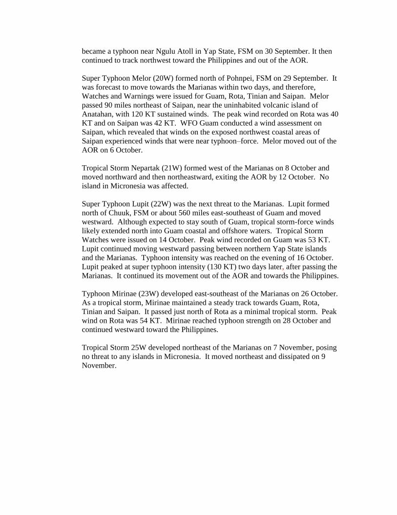
Super Typhoon Choi-wan’s passage over the island of Alamagan, a volcanic
island located 170 miles north of Saipan, in September brought widespread
damage and forced the evacuation of the island’s 14 residents to Saipan. A family
of six was first airlifted from the island the day after Choi Wan decimated the
island. Evacuation of the remaining residents, however, had to wait for a
chartered vessel and calmer sea conditions.
Figure 5: Helicopter evacuation of some of the Alamagan residents.
Later that month, Tropical Storm Parma passed directly over Ngulu, an atoll 50
miles southwest of Yap. Reports from Yap Emergency Management Office
indicated winds in excess of 60 mph that caused damage to four residential homes.
Food and emergency supplies on the remote atoll were sufficient to last for three
weeks but rainwater catchment tanks may have been contaminated with salt spray
from the high winds.
A comprehensive tropical cyclone outreach program for the 2009 Central Pacific
Hurricane Season generated a heightened awareness of emergency preparedness
in the State of Hawaii. The theme of the 2009 campaign, Hawaii’s First
Responders are Prepared, Are You?, focused on maintaining awareness of tropical
cyclone hazards, preparing emergency kits, and developing action plans for
individuals, families, and businesses. The possibility of developing El Nino
conditions and the consequent increase in tropical cyclone activity was a key
talking point in the RSMC Honolulu awareness campaign.
4. Regional Cooperation Assessment (highlighting regional cooperation successes
and challenges).
II. Summary of Progress in Key Result Areas
1. Progress on Key Result Area 1: Reduced Loss of Life from Typhoon-related
Disasters.
a. Meteorological - Achievements/Results
Active coordination between RSMC Honolulu forecasters, NOAA Marine
Fisheries, NOAA Office of Marine and Aviation Operations, the U.S. Coast
Guard, and the U.S. Fish and Wildlife Service resulted in the successful
evacuation of three remote islets in the Papahanaumokuakea National

Monument (NW Hawaiian Islands) in advance of Hurricane Neki. A total of
17 people were safely evacuated.
b. Hydrological – Achievements/Results
c. Disaster Prevention and Preparedness - Achievements/Results
d. Training, Research, and Other – Achievement/Results
RSMC Honolulu hosted a three-day class for 19 Emergency Managers and
First Responders on 14-16 April. The three-day pilot course was a specialized
training opportunity to build the capacity of the civil defense/emergency
manager to understand hurricanes and make effective protective action
decisions during a hurricane threat. Through hands-on and interactive
instruction with specialists at RSMC Honolulu, the course provided
participants with an intensive instruction on all aspects of tropical cyclone
forecasts and products, along with local National Weather Service forecast
office products.
e. Regional Cooperation – Achievement/Results
f. Identified Opportunities/Challenges for Future - Achievements/Results
2. Progress on Key Result Area 2: Minimized Typhoon-related Social and
Economic Impacts.
a. Meteorological - Achievements/Results
b. Hydrological – Achievements/Results
c. Disaster Prevention and Preparedness - Achievements/Results
FM Radio Station on Chuuk, FSM. An FM Weather Radio station was
installed at the Chuuk, FSM Weather Service Office (WSO) in 2007 and
gave the island the capability of reaching 75 percent of its population. In
2008, a repeater was installed on Weno that gave the broadcast an even
greater coverage. However, in 2009, the FM station was severely affected
by the frequent power outages on the island. To better cope with this, a
heavy duty power supply was purchased. A similar FM radio station
installed at the Majuro WSO in March 2008 will also be upgraded to
maintain its service time. Because of the remoteness of the many
atolls/islands in this region, broadcasting weather information on FM
radios provides vital weather information and warnings to a population
that is limited in its communication systems and is a step toward achieving
an early warning system for these islands.
d. Training, Research, and Other – Achievement/Results
e. Regional Cooperation – Achievement/Results
f. Identified Opportunities/Challenges for Future - Achievements/Results
3. Progress on Key Result Area 3: Enhanced Beneficial Typhoon-related Effects for
the Betterment of Quality of life.
a. Meteorological - Achievements/Results
b. Hydrological – Achievements/Results
c. Disaster Prevention and Preparedness - Achievements/Results
d. Training, Research, and Other – Achievement/Results
e. Regional Cooperation – Achievement/Results

f. Identified Opportunities/Challenges for Future - Achievements/Results
4. Progress on Key Result Area 4: Improved Typhoon-related Disaster Risk
Management in Various Sectors.
a. Meteorological - Achievements/Results
New Tropical Cyclone Products. RSMC Honolulu implemented several
new tropical cyclone products and changes to current products for the
2009 Central Pacific Hurricane Season. The first was the addition of a
three-tiered and color-coded scheme to describe the probability of
development for areas described in the graphical Tropical Weather
Outlook. The second was the tropical cyclone Wind Field Graphic which
displays the areas affected by tropical storm and hurricane force winds. A
graphical display of Tropical Cyclone SIGMETS was also added to the
RSMC product suite. Finally, the Maximum Wind Speed Probability
Wind Table was extended from 72 hours to 120 hours.
WFO Guam worked with the University of Guam’s (UOG’s) Water and
Environmental Research Institute (WERI) to produce up-to-date tropical
cyclone risk and return period charts and climatologies for each of the 37
islands for which WFO Guam issues Tropical Cyclone Watches and
Warnings. These new station climatology materials have been distributed
to many of the Micronesian islands.
b. Hydrological – Achievements/Results
c. Disaster Prevention and Preparedness - Achievements/Results
Hawaii State Hazard Mitigation Forum. The Hawaii State Hazard
Mitigation Forum, of which RSMC Honolulu is a member, is tasked with
maintaining and updating the Hawaii State Hazard Mitigation Plan.
Forum members met regularly and to discuss hazard threat, risk
assessment, and actions which can be taken to mitigate the hazard risk to
protect lives and property from loss and destruction during a natural
hazard.
RSMC Honolulu is a member of the Hawaii Emergency Preparedness
Executive Consortium (HEPEC). HEPEC is comprised of emergency
managers and disaster mitigation personnel from local, state, and federal
agencies. HEPEC meets quarterly to provide updates on current and
outstanding threats, both natural and manmade, to the State of Hawaii.
The RSMC Honolulu Director provided a hurricane presentation to the
group during the June 2009 meeting.
RSMC Honolulu staff was a contributing member in the development of
the Hawaii Catastrophic Hurricane Readiness Response Plan. The
catastrophic event was a strong Category 4 hurricane making landfall near
Ewa Beach on the island of Oahu. The Operations Plan provides specific
and detailed strategies to execute a joint State, local, Federal, Non-
Governmental Organizations, and Private sector preparation and response
in this situation. (See section 6d).
d. Training, Research, and Other – Achievement/Results
Exercise Pakyo. A two-day exercise sponsored by the Department of
Homeland Security/Federal Emergency Management Agency (FEMA)
was held on Guam on 9 to 10 June. WFO Guam participated in this
exercise and was responsible for devising the scenario of the exercise.
The scenario consisted of an intensifying Category 5 typhoon (super
typhoon) moving directly over Guam. Local and Federal government
agencies and several representatives of the private sector plus international
observers from the Philippines participated in the exercise.
Makani Pahili Hurricane Exercise. The annual Makani Pahili Hurricane
Exercise, coordinated by Hawaii State Civil Defense (CD) in partnership
with the National Weather Service (NWS) Forecast Office in Honolulu
was held from 26 May to 4 June. This year’s exercise was the culmination
of a year-long effort to develop, exercise, and validates the Hawaii
Catastrophic Hurricane Readiness Response Plan. RSMC Honolulu
exercised coordination procedures with civil defense and military partners
around Hawaii during the event.
e. Regional Cooperation – Achievement/Results
f. Identified Opportunities/Challenges for Future - Achievements/Results
5. Progress on Key Result Area 5: Strengthened Resilience of Communities to
Typhoon-related Disasters.
a. Meteorological - Achievements/Results
Monthly Pacific ENSO Discussion. Each month, WFO Guam Warning
Coordination Meteorologist (WCM) provides a written discussion on the
status of the El Nino-Southern Oscillation (ENSO) and its effects on
Micronesia. This discussion is relayed to weather officials, emergency
managers, US ambassadors and other agencies in Micronesia. These
discussions not only entail the trend of the ENSO but provide information
on hydrological and sea level conditions associated with it.
Hurricane Presentation to City and County of Honolulu Hawaii and
Cabinet. The Director of RSMC Honolulu provided a presentation on
hurricane risk and preparedness to the City and County of Honolulu
Mayor and his cabinet at their monthly staff meeting. Mayor, Honolulu
Police Department, Department of Emergency Management and others
expressed appreciation for WFO Honolulu’s great partnership and service.
b. Hydrological – Achievements/Results
c. Disaster Prevention and Preparedness - Achievements/Results
Rota StormReady/TsunamiReady Recognition. The island of Rota,
CNMI, was recognized as StormReady/TsunamiReady on 17 March.
StormReady and TsunamiReady are two prestigious NOAA programs that
recognize locations as being highly prepared to respond to and recover
from severe storms and tsunamis. In addition, the island of Guam
successfully renewed their recognition as StormReady/TsunamiReady for
another three years.
Annual Tropical Cyclone and Disaster Preparedness Workshop. These
two-day workshops are designed for decision makers in the local and state
governments and agencies cover various topics such as: tropical cyclone
behavior, structure and hazards; WFO Guam tropical cyclone program,
products and timing of products; tsunamis and volcanoes; rip currents,
currents, and tides; tropical cyclone plotting and speed-distance-time
computations; climate variability and climate change; typhoon risk and
vulnerability; a scale that relates tropical cyclone wind speed to damage
and storm surge; El Nino/La Nina and their effects, impacts and status;
and tropical cyclone decision making for individual islands/states. WFO
Guam conducted workshops at Pohnpei and Chuuk in the FSM, and at
Saipan, CNMI and on Guam.
National Disaster Preparedness Month. September was declared National
Disaster Preparedness Month for 2009. The Emergency Management
Offices on Guam and in the CNMI took the lead and arranged the events.
On Guam, several events and numerous activities such as school
presentations and a Grand Finale event at a major shopping center
showcased the Preparedness Month. WFO Guam participated in the
proclamation signing by the Governor of Guam, several awareness
activities with over 500 contacts, the Grand Finale Display at the local
Shopping Center with more than 150 contacts.
RSMC Honolulu Press Conference for the 2009 Central Pacific Hurricane
Season. RSMC Honolulu hosted a press conference to announce the 2009
Central Pacific Hurricane Season Outlook on 20 May. Following opening
remarks from the RSMC Honolulu Director, guest speaker Fire Chief
Kenneth Silva of the Honolulu Fire Department spoke on the role of first
responders in a disaster and keynote speaker Mufi Hanneman, Mayor of
the City and County of Honolulu touched on personal responsibility for
emergency preparedness. Theme of the week was “Hawaii’s First
Responders are Prepared, Are You?” All four local television stations
and the two state-wide newspapers attended the press conference and
featured stories that evening and/or the next day on hurricane preparedness
and the forecast for an 80 percent chance of a near to below normal season
and a 20 percent chance of an above normal season depending on the
development of El Nino in the Pacific.
Hurricane Preparedness Workshops. RSMC Honolulu personnel
conducted 17 hurricane related workshops including the annual CPHC
Press Conference and staffed booths at 5 emergency fairs. Overall, RSMC
Honolulu participated in a total of 111 educational or outreach events to
internal partners and external customers at all levels. These included
Hawaii Fishing and Seafood Festival (15,000 people attended); Waianae
Elementary School Career Day (300); as judges at the Hawaii State
Science and Engineering Fair (500); University of Hawaii School of Earth
and Ocean Science and Technology Open House (4,000 students).
Two RSMC Honolulu Hurricane Specialists were interviewed by The
Weather Channel for a special documentary on Hurricane Iniki which
devastated the island of Kauai, Hawaii, USA in 1992. The documentary,
which aired in late 2009, served as a stark reminder Hawaii is very
vulnerable to tropical cyclones in the Pacific, even though they have not
experienced a direct hit in nearly 20 years.
d. Training, Research, and Other – Achievement/Results
Aviation Workshop. An Aviation Workshop was held on Guam on 27
August and included presentations on the basic weather in the west Pacific,
typhoons and outlook for 2009, thunderstorms, wind shear, ENSO update
for aviators, and local aviation issues.
University of Guam lectures. Environmental Biology classes at the
University of Guam participated in lecture series at the WFO Guam during
the spring and fall semesters. WFO Guam WCM gave the 2-hour
presentation on basic weather plus hazards such as tropical cyclones,
volcanic eruptions and tsunamis.
Summer Science Programs. RSMC Honolulu participated in three
summer science programs for elementary and high school students. One
was for students from the “How to be a Weather Wiz Kid” class at
Kamehameha Schools to learn about tropical cyclones and severe weather
and the second were students from the “Discovering Science through
Aerospace” class at Mid Pacific Institute to learn about tropical cyclones
and climate in Hawaii. The third was the Sky and Space Class taught at
the University of Hawaii Lab School.
e. Regional Cooperation – Achievement/Results
f. Identified Opportunities/Challenges for Future - Achievements/Results
6. Progress on Key Result Area 6: Improved Capacity to Generate and Provide
Accurate, Timely, and understandable Information on Typhoon-related Threats.
a. Meteorological - Achievements/Results
RSMC Honolulu coordinated the deployment of Air Force Reserve WC-
130 and NOAA Gulf Stream hurricane reconnaissance aircraft as
Hurricane Felicia headed toward the main Hawaiian Islands. The flights
provided crucial data which greatly assisted RSMC forecasters.
RSMC Honolulu extended the lead time of tropical storm/hurricane
watches from 36 hours to 48 hours and the lead time of tropical
storm/hurricane warnings from 24 hours to 36 hours.
b. Hydrological – Achievements/Results
Hawaii Rain Gage Collection Network Replacement. NOAA NWS
Pacific Region received funding to implement the second year phase to
replace the entire rain gage collection network system in the state of
Hawaii. The new system is replacing the aging rain gages with new
technology and will use HF radio line of sight communication system
rather than land or cell phone lines. The project commenced in January
2009 to install the communication infrastructure. Eighteen new gages
have been installed to date.
c. Disaster Prevention and Preparedness - Achievements/Results
The Hawaii State CD installed video teleconference (VTC) equipment at
RSMC Honolulu on a dedicated circuit. The equipment provides a
valuable communication tool to effectively provide coordination during
severe weather events. The equipment complements a VTC system
installed by the FEMA in 2007 which is now kept as a backup.
WFO Guam WCM participated in the 2009 UNESCAP/TCP Roving
Seminar held in Nanjing, China from 16-19 November, 2009. His
participation included a discussion of the requirements for and content of
tropical cyclone warning messages. In this training, the WCM included
background and review of the needs of a strong National disaster
preparedness program and provided a large selection of tools that could
improve tropical cyclone warnings. Finally, a hands-on assessment of
warnings of each of the eight participating countries was conducted.
RSMC Honolulu served on the national HazCollect Implementation Team.
HazCollect is a system which allows Emergency Managers to send Civil
Emergency Messages directly to NOAA Weather Radio for broadcast in
regions of the USA or throughout the entire USA. WFO Honolulu and
Hawaii State CD jointly participated in the initial alpha testing starting in
late 2008 and was one of the first offices to implement HazCollect
operationally in 2009. Guam also implemented HazCollect, which
extended the capabilities to the Guam and CNMI Governors and
Emergency Managers.
On two occasions, RSMC Honolulu hosted Forecasters and Typhoon Duty
Officers from the Naval Maritime Forecast Center (NMFC) and Joint
Typhoon Warning Center (JTWC). The visits were to familiarize NMFC
and JTWC staff with RSMC Honolulu operations and forecast software
packages and to increase collaboration amongst the two agencies.
d. Training, Research, and Other – Achievement/Results
In-house seminars. WFO Guam held two seminars for local forecasters
and military components on island. The QuikSCAT seminar provided by
the WFO Guam Science and Operations Office (SOO), was held on 6 and
14 April. Those in attendance walked away with an understanding of the
processes behind QuikSCAT and its strengths and weaknesses. The
second seminar was an introduction to the Dvorak Analysis Technique by
the SOO and the Guam WCM.
Tropical Cyclone Conference. Commander in Chief US Pacific Fleet
(CINPACFLT) held a Tropical Cyclone Conference and the METSAT
Conference from 27 April to 1 May at Pearl Harbor, Hawaii. Some
highlights from the conference included a discussion on the Automated
Meteorological Observing System (AMOS) network, the potential loss of
Scatterometer and ocean wave altimetry data, and the civilianization of the
JTWC Director and three forecasters to improve continuity and experience.
JTWC also celebrated it 50th
Anniversary, inviting past JTWC Directors
and Navy Commanders to attend the ceremony.
Mr. Richard Grumm, Science and Operations Officer, NWS State College,
Pennsylvania, presented a detailed three-day seminar, 9 to 11 September
to WFO Guam personnel on the use of NWP ensemble techniques for
improving forecasts in the tropics. His presentations were well received
and greatly enhanced all participants’ appreciation for the latest NWP
techniques, especially in better understanding the degree of uncertainty
and probabilities associated with tropical cyclone track predictions.
WFO Guam SOO participated in a community white paper presented at
the OceanObs’09 symposium, Venice, Italy 21-25 September on the
satellite-derived surface winds component of the observing system, with
applications for operations and for climate prediction.
From 1 January to 31 October, the Pacific International Desk Training
Programme, RSMC Honolulu, Hawaii Islands, USA trained 6 forecasters
from 6 different members of WMO Regional Association (RA) V regions,
including Samoa, Vanuatu, New Guinea, Philippines, Solomon Islands,
and Tonga. Since its inception in 2001, 52 people from 15 Members of
WMO RA V and 2 Members from the Typhoon Committee have attended
this programme. The USA government, through NOAA NWS funded the
training programme.
FEMA and the Hawaii State CD Catastrophic Disaster Event Planning.
FEMA, Hawaii State CD, the University of Hawaii, Pacific Disaster
Center, and RSMC Honolulu completed the development, exercise, and
validation of the Hawaii Catastrophic Hurricane Readiness Response Plan
in 2009. The plan features a strong Category 4 hurricane hitting the most
populated area of Honolulu, Hawaii. As part of this planning, the
University of Hawaii developed a very sophisticated Storm Inundation
model for island communities with coral reefs. RSMC Honolulu
developed 12 hurricane tracks with varying tracks, speed of movement,
intensity, and size. FEMA executes part 1b of the plan with a hurricane in
the central Pacific approaching Hawaii, and 1c either when a watch is
issued for the islands or the probability of hurricane force winds are
between 10 and 20 percent for any place on the islands. At stage 1b,
FEMA expends significant funds by pre-locating people and resources,
because of the isolated nature of the Hawaiian Islands.
As part of the Hollings Scholar program, a student from Florida State
University spent 9 weeks at RSMC Honolulu. This scholar along with the
Deputy Director of RSMC Honolulu conducted studies of probabilistic
tropical cyclone genesis in the central Pacific. All available data on
tropical cyclones were used with Dvorak fixes as one of the major data
sources. This research continues and in the future may involve RSMC
Miami and the Atlantic Ocean.
RSMC Honolulu continues to advocate for real time ocean vector winds
for the future. The Deputy Director is part of the Operations Team
associated with the planning, development, and coordination with NASA,
Japan, and others on replacements to Quikscat winds.
Wind probabilities for tropical storm and hurricane force winds out to 120
hours play an important part in the ability of RSMC Honolulu to
communicate risks to emergency managers and other decision makers.
RSMC Honolulu is working with RSMC Miami on a Joint Hurricane
Testbed project to continue to improve the beneficial use of these
probabilistic winds.

Hurricane Specialists and Hurricane Forecasters at RSMC Honolulu
completed their annual hurricane and Dvorak technique training.
WFO Guam worked with the Pacific ENSO Applications Center (PEAC)
to issue quarterly newsletters that included 1-year predictions of tropical
cyclone activity, rainfall and sea level fluctuation. In coordination with
the US Climate Prediction Center, the WFO Guam WCM also produced
and issued 1-page Monthly Pacific ENSO Discussions for the Micronesian
islands and American Samoa in RA-V.
e. Regional Cooperation – Achievement/Results
RSMC Honolulu Deputy Director attended two meetings with the Japan
Aerospace Agency to collaborate on their next generation of satellites
which will provide ocean surface wind vector data similar to current
Quikscat data used to assess the strength and structure of tropical cyclones.
RSMC Honolulu participated in an international test of Tropical Cyclone
SIGMET dissemination which was coordinated by the WMO. RSMC
Honolulu issued a test Tropical Cyclone Advisory followed by a test
Tropical Cyclone SIGMET.
f. Identified Opportunities/Challenges for Future - Achievements/Results
7. Progress on Key Result Area 7: Enhanced Typhoon Committee’s Effectiveness
and International Collaboration.
a. Meteorological - Achievements/Results
b. Hydrological – Achievements/Results
USA participated in the Typhoon Committee Integrated Workshop
“Building sustainability and Resilience in High-Risk Areas of the
Typhoon Committee” in Cebu, Philippines from 14 to 18 September.
Technical studies and regional cooperation opportunities concerning flood
hazard mapping and debris flows in Micronesia were discussed.
c. Disaster Prevention and Preparedness - Achievements/Results
The US Member of the Typhoon Committee Working Group on Disaster
Prevention and Preparedness (WGDPP) participated in 4th
annual meeting
of the WGDPP in Seoul, Korea on 28 to 29 April. As a result, USA will
participate in the Hong Kong pilot project called “Weather Wizard”.
d. Training, Research, and Other – Achievement/Results
The US Member of the Training and Research Coordinating Group
(TRCG) participated in a one-week Technical Workshop sponsored by the
TRCG and held at the new Typhoon Forecast Center, Korea
Meteorological Administration (KMA), Jeju Island, South Korea, 12 to 15
May. The emphasis was on ensemble forecasting techniques (the US
member helped select the speaker, Dr Russ Elsberry, for this portion of the
workshop) and on Typhoon Information Processing Systems (TIPS). The
US member also presented a lecture on the use of current satellite-based
microwave data techniques to forecast and detect tropical cyclones to the
workshop.
e. Regional Cooperation – Achievement/Results
f. Identified Opportunities/Challenges for Future - Achievements/Results

III. Resource Mobilization Activities
IV. Update of Members’ Working Groups representatives
1. Working Group on Meteorology
Mr. Bill Ward
Pacific Guardian Center
737 Bishop Street, Suite 2200
Honolulu, HI 96813-3213
Phone: 808-532-6415
Facsimile: 808-532-5569
2. Working Group on Hydrology
Mr. Michael Ziobro
3232 Hueneme Road
Barrigada, GU 96913
Phone: 671-472-0950
Facsimile: 671-472-7405
3. Working Group on Disaster Prevention and Preparedness
Ms. Genevieve Miller
3232 Hueneme Road
Barrigada, GU 96913
Phone: 671-472-0944
Facsimile: 671-472-0980
4. Training and Research Coordinating Group
Mr. Roger Edson
3232 Hueneme Road
Barrigada, GU 96913
Phone: 671-472-0950
Facsimile: 671-472-7405
5. Resource Mobilization Group
Mr. James Weyman
2525 Correa Road, Suite 250
Honolulu, HI 96822-2219
Phone: 808-973-5272
Facsimile: 808-973-5271


![MEMBER REPORT [China] - Typhoon Committee REport/CHina/Me… · MEMBER REPORT [China] ESCAP/WMO Typhoon Committee 13th Integrated Workshop Chiang Mai, Thailand 5-9 November 2018](https://img.dokumen.tips/doc/110x75/5f0e10ab7e708231d43d719c/member-report-china-typhoon-reportchiname-member-report-china-escapwmo.jpg)