Embed Size (px)
Citation preview
Unit 5
Desk-based AssessmentAuthors Hans K. Van Tilburg and Mark Staniforth
The Protection of the Underwater Cultural Heritage

Core Knowledge of the Unit ............................................................... 2
Introduction to the Unit ........................................................................ 2
1 Report Introduction ................................................................ 3
2 Identification of the Survey Area ...................................... 3
3 Existing Preservation Legislation ...................................... 3
4 Methods and Sources .......................................................... 5
5 Baseline Conditions ............................................................... 11
6 Significance Evaluation ....................................................... 14
7 Potential Impacts ................................................................... 14
8 Recommended Mitigation Actions ...............................16
Unit Summary ..........................................................................................19
Suggested Timetable ............................................................................19
Teaching Suggestions .......................................................................... 20
Suggested Reading: Full List ............................................................. 21
Unit 5 Contents
Published by UNESCO BangkokAsia and Pacific Regional Bureau for EducationMom Luang Pin Malakul Centenary Building920 Sukhumvit Road, Prakanong, KlongtoeyBangkok 10110, Thailand
© UNESCO 2012All rights reserved
ISBN: 978-92-9223-413-3 (Print version) ISBN: 978-92-9223-414-0 (Electronic version)
The designations employed and the presentation of material throughout this publication do not imply the expression of any opinion whatsoever on the part of UNESCO concerning the legal status of any country, terri-tory, city or area or of its authorities, or concerning the delimitation of its frontiers or boundaries.
The authors are responsible for the choice and the presentation of the facts contained in this book and for the opinions expressed therein, which are not necessarily those of UNESCO and do not commit the organization.
UNESCO Bangkok is committed to widely disseminating information and to this end welcomes enquiries for reprints, adaptations, republishing or translating this or other publications. Please contact [email protected] for further information.
Technical editing: Martijn R. Manders and Christopher J. UnderwoodCopy-editing: Sara M. Mabelis Design/Layout/Illustration: Warren FieldCover photo: Desk-based assessments must be conducted prior to undertaking any on-site activities.
© UNESCO/J. Gribble
Printed in Thailand
CLT/12/OS/015

2
Training Manual for the UNESCO Foundation Course on the Protection and Management of Underwater Cultural Heritage in Asia and the Pacific U N I T 5 D E S K - B A S E D A S S E S S M E N T
3
Unit 5
Core Knowledge of the UnitThe Desk-based Assessment unit clarifies the role that document or archival based surveys play in the management of underwater cultural heritage resources, and provides students with guidance on com-pleting and presenting these critical assessments. As a management tool, desk-based assessments are particularly focused on mitigating human impacts to heritage resources.
Familiarity with desk-based assessments is vital to the preservation of the underwater cultural heritage, as these types of reports are an essential tool in the resource management kit.
Upon completion of the Desk-based Assessment unit, students will:
• Describe the main components of a desk-based assessment report
• Discuss various impact types and the need for an assessment report
• Be familiar with a broad range of potential underwater cultural heritage resources
• Be familiar with a broad range of source material related to underwater cultural heritage
• Be able to prioritize primary and secondary information
• Be able to provide a summary of recommendations necessary for the preservation manage-ment of the underwater cultural heritage resource
Introduction to the UnitDesk-based assessment reports are aimed at a comprehensive understanding of underwater cultural heritage resources within a specific survey area, in order to mitigate or avoid impacts from ocean devel-opment projects of various kinds. These assessments may include information from field surveys and may also recommend (but do not necessarily require) that further field surveys be undertaken. Essen-tially, desk-based assessments provide the most comprehensive overview of underwater cultural heri-tage resources drawn from existing information sources for management purposes.
The process of creating a desk-based assessment report is in some ways similar to the background histori-cal and archival research accomplished in support of a wide range of underwater cultural heritage proj-ects. The assessment, however, focuses on the broad potential of underwater cultural heritage resources within a potential impact area, rather than any single resource or resource type, and directly addresses management issues related to resource preservation and human impacts.
Desk-based assessments are important tools in under-standing and protecting underwater cultural heritage and managing change. Although reports based on desk-based assessments increasingly form part of the planning process and are often included in conserva-tion management plans and environmental assess-ments, many maritime archaeologists have little or no training in researching, compiling and presenting them.
Desk-based assessment reports are comprised of specific elements which lead to and support a set of recommendations for the preservation of underwater cultural heritage resources.
1 Report Introduction
At a minimum, the introduction of the desk-based assessment report needs to communicate to the reader the time frame of the report’s production, the agencies or programs involved, the general area surveyed and (perhaps most importantly) the reason the assessment is being produced. What agency or action pro-moted the need for the assessment? The introduction needs to do all this in a clear and succinct manner.
2 Identification of the Survey Area
A general description of the survey area must be included as part of the assessment report. The gen-eral description features a number of parametres, including water depth (range), bottom type, water temperature, winds, even storm patterns and frequency. These are all factors which affect the status of underwater cultural heritage resource and site formation processes. Past and present human uses of the marine environment within the survey area must also be considered (e.g. fishing, diving and sal-vage), as changes in them may have consequences for underwater cultural heritage.
In addition to a general description, the exact boundaries of the area being considered for the assessment need to be clearly represented in both written (text) and graphic (map or chart) formats. Remember, these boundaries will often represent broad areas of potential project impacts, rather than boundaries defining the spatial limits of any single archaeological site. Written descriptions generally include a table featuring specific latitude and longitude waypoints, defining the exact boundaries of the project area. Maps should be the most current editions available. Geographic Information Systems (see Unit 8: Geographical Information Systems (GIS) in Underwater Archaeology) provide a powerful tool with which to portray bounded marine areas, subsequently overlain with underwater cultural heritage resource sites, potential impact sites and zones of protective legislation.
3 Existing Preservation LegislationUnderwater cultural heritage legislation is comprised of any legal preservation mandates and guide-lines that are aimed specifically at underwater cultural heritage resource within the survey area. Com-pared with existing mandates for the protection of natural resources, cultural resource preservation measures may be relatively unknown, even to programmes and agencies responsible for the protection of cultural resources.
Unit 5 Desk-based Assessment
Authors Hans K. Van Tilburg and Mark Staniforth These elements are:
• Report introduction
• Identification of the survey area
• Existing preservation legislation
• Methods and sources
• Baseline conditions
• Significance evaluation
• Potential impacts
• Recommended mitigation actions
4
Training Manual for the UNESCO Foundation Course on the Protection and Management of Underwater Cultural Heritage in Asia and the Pacific U N I T 5 D E S K - B A S E D A S S E S S M E N T
5
Unit 5
Nations which have adopted and ratified the UNESCO Convention on the Protection of the Underwater Cultural Heritage (Paris 2001) have, within its Annex, appropriate guidelines for documenting and protect-ing underwater cultural heritage resource. In addition, nations may have defined laws protecting historic properties and/or archaeological sites within their territorial waters. It is often the case that laws which pro-tect historic properties on land are, in fact, applicable to submerged bottomlands (and underwater cultural heritage), though marine areas may not be specifically mentioned.
Shipwreck sites, particularly more modern resources such as those associated with the First World War, may include materials like ordnance or fuel oil which represent potential threats to the marine environ-ment. Therefore, environmental protection laws which may not at first seem applicable to the under-water cultural heritage may also need to be considered. For instance, laws requiring the protection of marine mammal habitat can have ramifications for any activity which might damage Second World War era shipwrecks (potentially releasing trapped fuel oil). Resource managers need to think broadly when considering the various mandates which influence the protection of underwater cultural heritage.
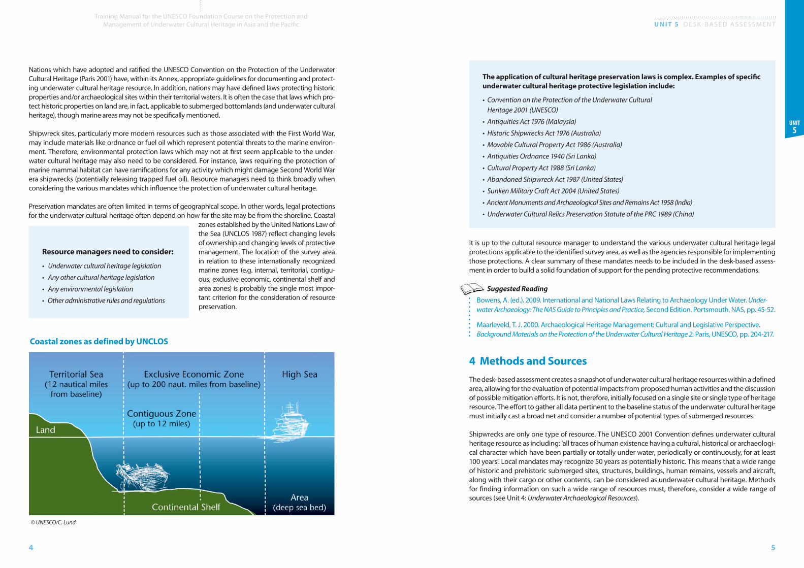
Preservation mandates are often limited in terms of geographical scope. In other words, legal protections for the underwater cultural heritage often depend on how far the site may be from the shoreline. Coastal
zones established by the United Nations Law of the Sea (UNCLOS 1987) reflect changing levels of ownership and changing levels of protective management. The location of the survey area in relation to these internationally recognized marine zones (e.g. internal, territorial, contigu-ous, exclusive econo mic, continental shelf and area zones) is probably the single most impor-tant criterion for the consideration of resource preservation.
The application of cultural heritage preservation laws is complex. Examples of specific underwater cultural heritage protective legislation include:
• Convention on the Protection of the Underwater Cultural Heritage 2001 (UNESCO)
• Antiquities Act 1976 (Malaysia)
• Historic Shipwrecks Act 1976 (Australia)
• Movable Cultural Property Act 1986 (Australia)
• Antiquities Ordnance 1940 (Sri Lanka)
• Cultural Property Act 1988 (Sri Lanka)
• Abandoned Shipwreck Act 1987 (United States)
• Sunken Military Craft Act 2004 (United States)
• Ancient Monuments and Archaeological Sites and Remains Act 1958 (India)
• Underwater Cultural Relics Preservation Statute of the PRC 1989 (China)
It is up to the cultural resource manager to understand the various underwater cultural heritage legal protections applicable to the identified survey area, as well as the agencies responsible for implementing those protections. A clear summary of these mandates needs to be included in the desk-based assess-ment in order to build a solid foundation of support for the pending protective recommendations.
Suggested ReadingBowens, A. (ed.). 2009. International and National Laws Relating to Archaeology Under Water. Under-water Archaeology: The NAS Guide to Principles and Practice, Second Edition. Portsmouth, NAS, pp. 45-52.
Maarleveld, T. J. 2000. Archaeological Heritage Management: Cultural and Legislative Perspective. Background Materials on the Protection of the Underwater Cultural Heritage 2. Paris, UNESCO, pp. 204-217.
4 Methods and Sources The desk-based assessment creates a snapshot of underwater cultural heritage resources within a defined area, allowing for the evaluation of potential impacts from proposed human activities and the discussion of possible mitigation efforts. It is not, therefore, initially focused on a single site or single type of heritage resource. The effort to gather all data pertinent to the baseline status of the underwater cultural heritage must initially cast a broad net and consider a number of potential types of submerged resources.
Shipwrecks are only one type of resource. The UNESCO 2001 Convention defines underwater cultural heritage resource as including: ‘all traces of human existence having a cultural, historical or archaeologi-cal character which have been partially or totally under water, periodically or continuously, for at least 100 years’. Local mandates may recognize 50 years as potentially historic. This means that a wide range of historic and prehistoric submerged sites, structures, buildings, human remains, vessels and aircraft, along with their cargo or other contents, can be considered as underwater cultural heritage. Methods for finding information on such a wide range of resources must, therefore, consider a wide range of sources (see Unit 4: Underwater Archaeological Resources).
Resource managers need to consider:
• Underwater cultural heritage legislation
• Any other cultural heritage legislation
• Any environmental legislation
• Other administrative rules and regulations
Coastal zones as defined by UNCLOS
© UNESCO/C. Lund

6
Training Manual for the UNESCO Foundation Course on the Protection and Management of Underwater Cultural Heritage in Asia and the Pacific U N I T 5 D E S K - B A S E D A S S E S S M E N T
7
Unit 5
ABOVE: A Second World War era naval aircraft identified as an American SB2C Helldiver. © NOAA Sanctuaries
FAR RIGHT: Scotch boiler of the SS Maui; shipwrecks are probably the most familiar type of underwater cultural heritage. © University of Hawaii Marine Option Program
RIGHT: Steam powered winch; vessel landing sites and the remains of his-toric piers feature cargo handling equipment and the accumulated artefacts that result from decades of human use. © University of Hawaii Marine Option Program/J. Coney
8
Training Manual for the UNESCO Foundation Course on the Protection and Management of Underwater Cultural Heritage in Asia and the Pacific U N I T 5 D E S K - B A S E D A S S E S S M E N T
9
Unit 5
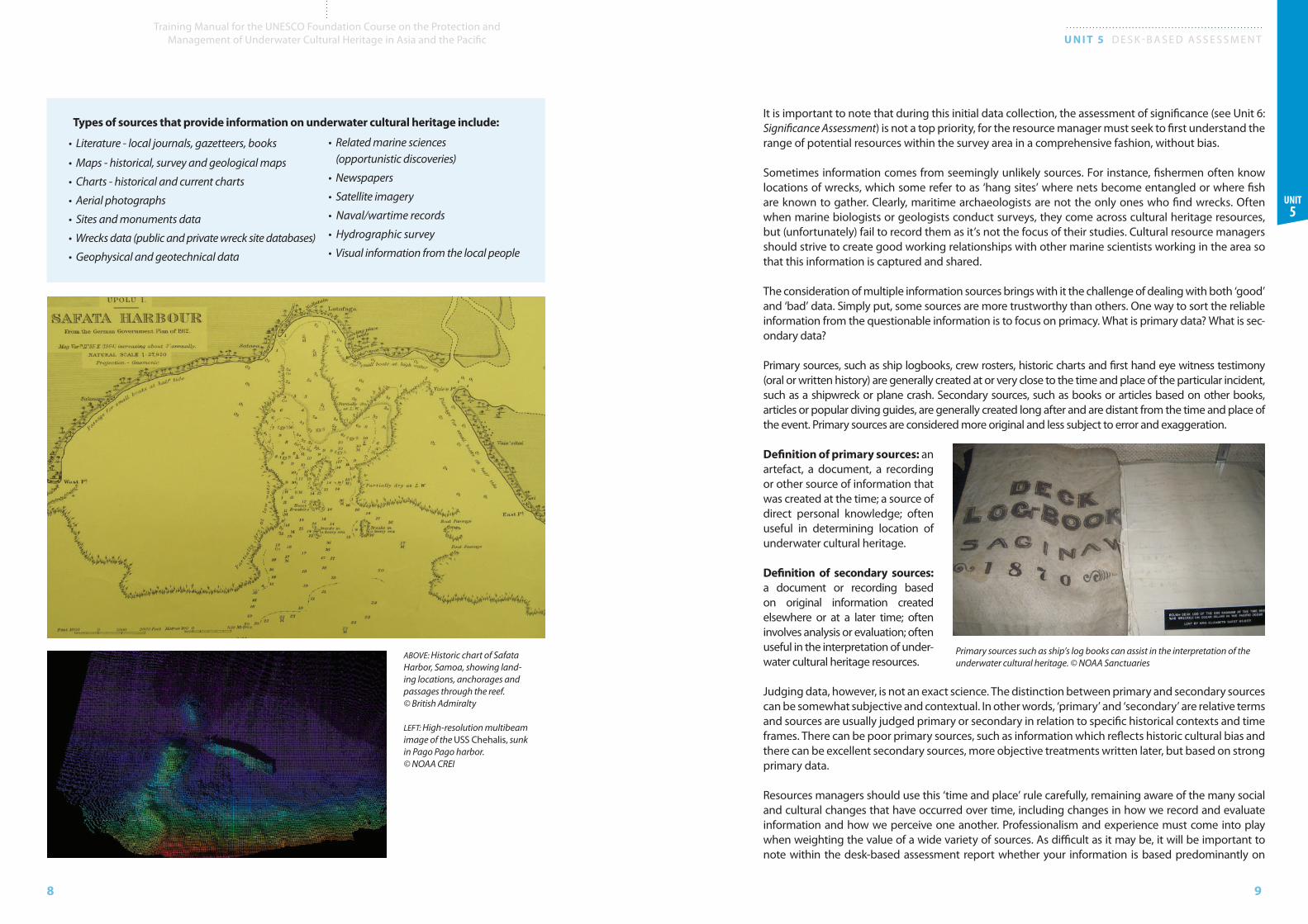
• Literature - local journals, gazetteers, books
• Maps - historical, survey and geological maps
• Charts - historical and current charts
• Aerial photographs
• Sites and monuments data
• Wrecks data (public and private wreck site databases)
• Geophysical and geotechnical data
ABOVE: Historic chart of Safata Harbor, Samoa, showing land-ing locations, anchorages and passages through the reef. © British Admiralty
LEFT: High-resolution multibeam image of the USS Chehalis, sunk in Pago Pago harbor. © NOAA CREI
Types of sources that provide information on underwater cultural heritage include:
• Related marine sciences (opportunistic discoveries)
• Newspapers
• Satellite imagery
• Naval/wartime records
• Hydrographic survey
• Visual information from the local people
It is important to note that during this initial data collection, the assessment of significance (see Unit 6: Significance Assessment) is not a top priority, for the resource manager must seek to first understand the range of potential resources within the survey area in a comprehensive fashion, without bias.
Sometimes information comes from seemingly unlikely sources. For instance, fishermen often know locations of wrecks, which some refer to as ‘hang sites’ where nets become entangled or where fish are known to gather. Clearly, maritime archaeologists are not the only ones who find wrecks. Often when marine biologists or geologists conduct surveys, they come across cultural heritage resources, but (unfortunately) fail to record them as it’s not the focus of their studies. Cultural resource managers should strive to create good working relationships with other marine scientists working in the area so that this information is captured and shared.
The consideration of multiple information sources brings with it the challenge of dealing with both ‘good’ and ‘bad’ data. Simply put, some sources are more trustworthy than others. One way to sort the reliable information from the questionable information is to focus on primacy. What is primary data? What is sec-ondary data?
Primary sources, such as ship logbooks, crew rosters, historic charts and first hand eye witness testimony (oral or written history) are generally created at or very close to the time and place of the particular incident, such as a shipwreck or plane crash. Secondary sources, such as books or articles based on other books, articles or popular diving guides, are generally created long after and are distant from the time and place of the event. Primary sources are considered more original and less subject to error and exaggeration.
Definition of primary sources: an artef act, a document, a recording or other source of information that was created at the time; a source of direct personal knowledge; often useful in determining location of underwater cultural heritage.
Definition of secondary sources: a document or recording based on original information created elsewhere or at a later time; often involves analysis or evaluation; often useful in the interpretation of under-water cultural heritage resources.
Judging data, however, is not an exact science. The distinction between primary and secondary sources can be somewhat subjective and contextual. In other words, ‘primary’ and ‘secondary’ are relative terms and sources are usually judged primary or secondary in relation to specific historical contexts and time frames. There can be poor primary sources, such as information which reflects historic cultural bias and there can be excellent secondary sources, more objective treatments written later, but based on strong primary data.
Resources managers should use this ‘time and place’ rule carefully, remaining aware of the many social and cultural changes that have occurred over time, including changes in how we record and evaluate information and how we perceive one another. Professionalism and experience must come into play when weighting the value of a wide variety of sources. As difficult as it may be, it will be important to note within the desk-based assessment report whether your information is based predominantly on
Primary sources such as ship’s log books can assist in the interpretation of the underwater cultural heritage. © NOAA Sanctuaries
10
Training Manual for the UNESCO Foundation Course on the Protection and Management of Underwater Cultural Heritage in Asia and the Pacific U N I T 5 D E S K - B A S E D A S S E S S M E N T
11
Unit 5
primary or secondary data. Primary source material should be emphasized in the assessment report, whereas secondary material may or may not be critical enough to be specifically noted as such in the text. In any case, all references should be listed in the report bibliography.
The following questions may help in the determination of primary or secondary information:
• When was the document written? Where was it written?
• How close is this to the particular event in question?
• What kind of document is it and who was the intended audience? Official? Private?
• Is there potential for cross-cultural bias in the document?
• How authoritative was the creator of the document?
• Would they really have known about the subject?
• Why was this document created in the first place? Was there any ulterior motive?
In order to use information most effectively in the desk-based assessment, sources must be carefully identified. This is done by systematically citing each source, in other words, providing clear information on each important source, so that the reader could (if so desired) locate that source on their own initia-tive. Researchers should be in the habit of recording provenance information not just for artefacts, but for documentary material as well. This includes proper bibliographic citations for books and articles, legal citations for preservation mandates, archive location information, photographs, etc. Often spe-cific archives have a preferred format for citations from their collections. All references should be listed in the desk-based assessment report bibliography.
There are different citation styles appropriate to the nature of the specific publication and audience. For instance, UNESCO related documents produced in the Asia-Pacific region may rely on the UNESCO Bangkok Style Guide for English Language (February 2007). See http://www.unescobkk.org/index.php?id=publication_procedures (Accessed November 2011).
The important thing is to be consistent and thorough when it comes to citing your critical references.
Suggested ReadingBowens, A. (ed.). 2009. Historical Research. Underwater Archaeology: The NAS Guide to Principles and Practice, Second Edition. Portsmouth, NAS, pp. 65-70.
Manders, M. 2004. Safeguarding a Site: The Master Management Plan. MOSS Newsletter. March 2004, pp. 16-19.
Viduka, A. 2006. Managing Threats to Underwater Cultural Heritage Sites: the Yongala as a Case Study. Underwater Cultural Heritage at Risk: Managing Natural and Human Impacts, pp. 61-63.
5 Baseline Conditions
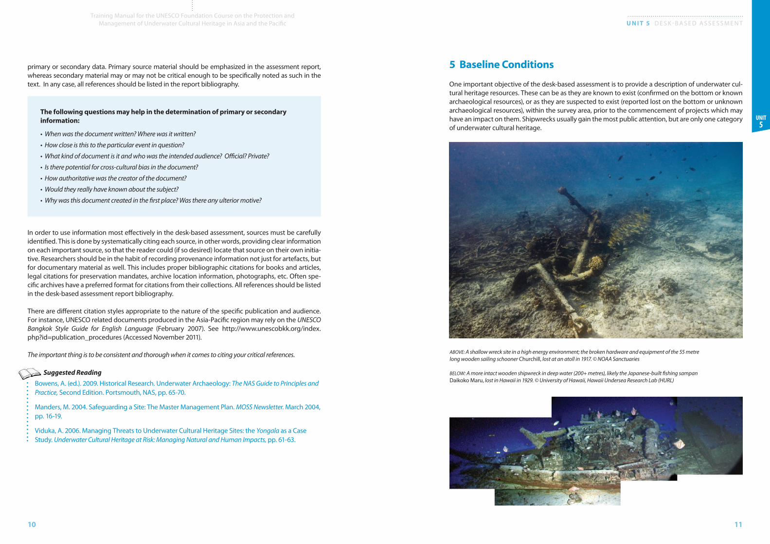
One important objective of the desk-based assessment is to provide a description of underwater cul-tural heritage resources. These can be as they are known to exist (confirmed on the bottom or known archaeological resources), or as they are suspected to exist (reported lost on the bottom or unknown archaeological resources), within the survey area, prior to the commencement of projects which may have an impact on them. Shipwrecks usually gain the most public attention, but are only one category of underwater cultural heritage.
ABOVE: A shallow wreck site in a high energy environment; the broken hardware and equipment of the 55 metre long wooden sailing schooner Churchill, lost at an atoll in 1917. © NOAA Sanctuaries
BELOW: A more intact wooden shipwreck in deep water (200+ metres), likely the Japanese-built fishing sampan Daikoko Maru, lost in Hawaii in 1929. © University of Hawaii, Hawaii Undersea Research Lab (HURL)
12
Training Manual for the UNESCO Foundation Course on the Protection and Management of Underwater Cultural Heritage in Asia and the Pacific U N I T 5 D E S K - B A S E D A S S E S S M E N T
13
Unit 5
tion sites) benefits from collaboration with geographers and oceanographers. The retreat of the glaciers during the last ice age (approximately 10,000 BP) raised the ocean levels, in some places by as much as 100 metres. The potential now exists for submerged habitation sites in many places of the world.
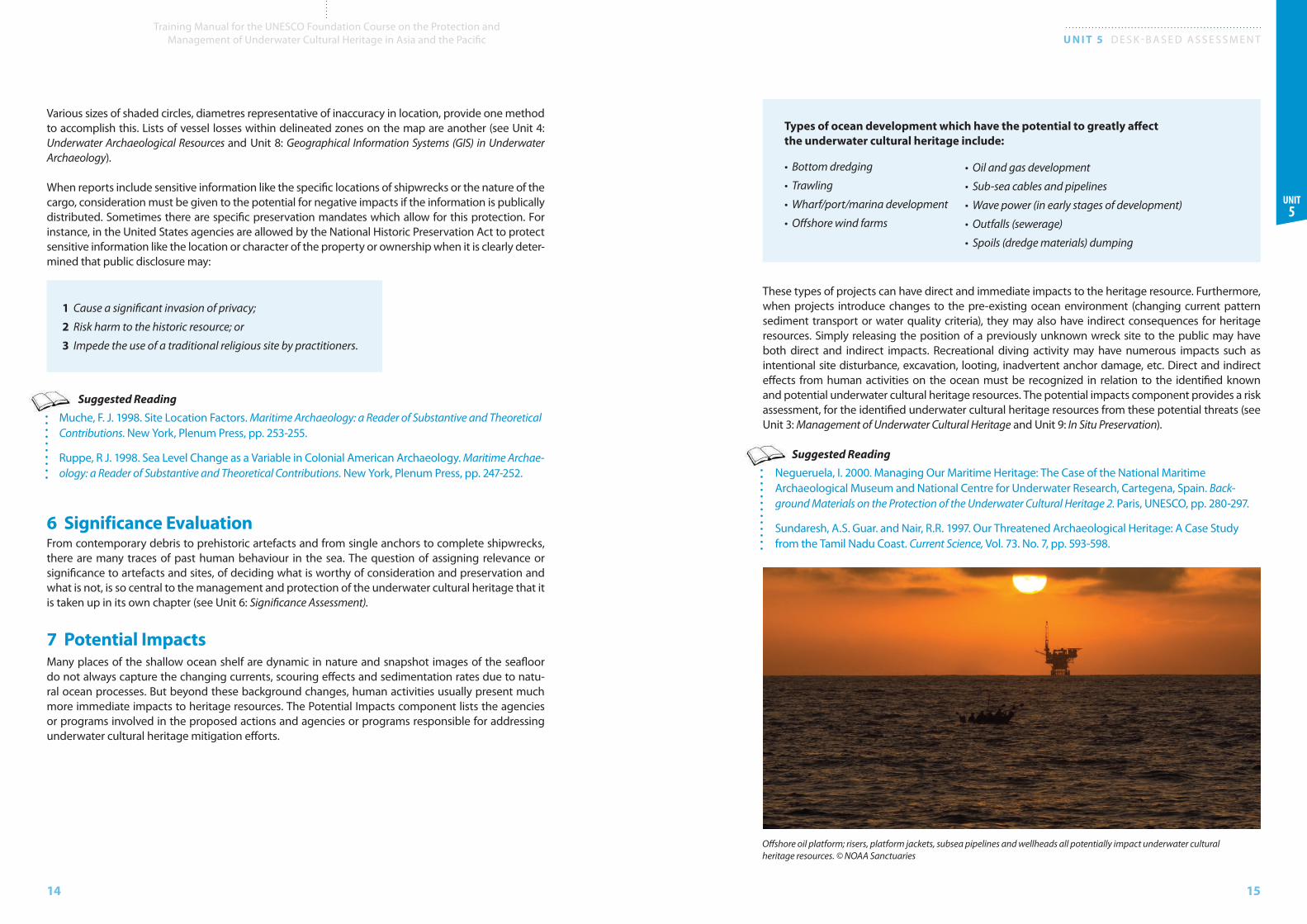
Just as prehistoric habitation sites may reflect a pattern in the use of the environment, historic activities on the coasts and seas may be patterned as well. For example, in Hawaii during the Second World War, many naval aircraft were lost in the sea immediately upon takeoff (when the aircraft failed to maintain sufficient power). As a result, submerged aircraft can often be found in a line extending directly from the runway of the naval air station to the ocean. In the days of sail, harbours and coastal anchorages, particularly those with narrow passages through the barrier reef, claimed many wooden vessels, simply because this was where the ships had to come closest to shoreline hazards. Steam propulsion opened parts of the coast which were previously unavailable to sail and early steam landings saw the same kind of cumulative grouping over time. Finally, so called ‘ship traps’ can occur where maritime trade routes converge with prevailing winds and currents upon a lee shore (or some other land obstruction).
Simply put, the distribution of many types of underwater cultural heritage is neither random nor uni-form, but patterned. Areas that have a high probability of underwater cultural heritage due to prehis-toric or historic uses should be called out in the desk-based assessment report.
In order to present a clear picture of underwater cultural heritage resources within the survey area, the cultural resource manager must grapple with a wide variety of known and potential properties which range from fixed (precise) or general (vague) locations. A graphic summary of submerged resources often involves the production of some form of map. This raises two immediate issues which must be considered when mapping known and reported losses. How can unconfirmed but reported losses be represented graphically for an audience? And how can the position of confirmed (located) resources which may be sensitive to potential threats be protected? Fixed points on a chart easily pinpoint the location of known sites, but there is no single or best depiction for reported but unconfirmed losses.
Sections related to baseline conditions typically include a description of the underlying geology and environment and landscape history, and a brief historical background to the study area. This material leads directly into a discussion of the nature of underwater cultural heritage resources. Information on various underwater cultural resources must be compiled from a wide range of sources and reflect an attempt to be objective, rather than favour one single type of heritage resource over another. In addi-tion, the baseline condition section should assess the state of preservation of heritage resources within the survey area (see Unit 4: Underwater Archaeological Resources). This can include a description of site formation processes.
Information from the sources will vary widely in terms of accuracy and reliability. Dealing with every-thing from geo referenced side scan and magnetometer data to unconfirmed rumours will be chal-lenging. Furthermore, resources managers should remain aware that the standard survey tools of underwater archaeology, particularly the magnetometer, may be biased towards representing a greater proportion of historic shipwreck remains relative to pre-iron age sites. Detecting lithic artefacts like stone structures, tools or such things as pre-iron age wooden fishing weirs, is much more difficult. Remote sensing tools like side scan sonar and magnetometer have proven to be much more useful in some environments, such as broad flat sediment bottoms of river deltas, than others, such as the spur and groove coralline topography of oceanic atolls. Existing survey data is not always representative of the actual resource base.
There may be a patterned distribution of underwater cultural heritage resources within the survey area, reflecting past human seafaring behaviour, such as fishing activities or regular trade and com-munication routes.
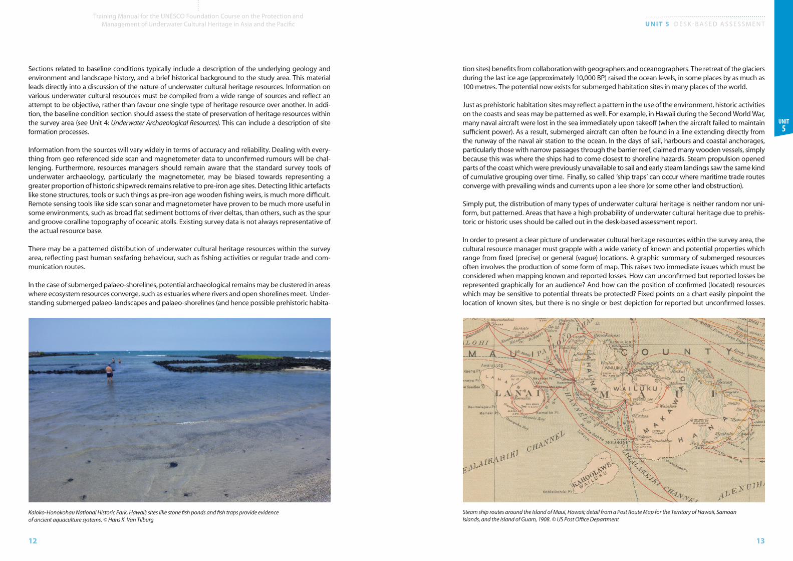
In the case of submerged palaeo-shorelines, potential arch ae o logical remains may be clus tered in areas where ecosystem resources converge, such as estuaries where rivers and open shorelines meet. Under-standing submerged palaeo-landscapes and palaeo-shorelines (and hence possible prehistoric habita-
Kaloko-Honokohau National Historic Park, Hawaii; sites like stone fish ponds and fish traps provide evidence of ancient aquaculture systems. © Hans K. Van Tilburg
Steam ship routes around the Island of Maui, Hawaii; detail from a Post Route Map for the Territory of Hawaii, Samoan Islands, and the Island of Guam, 1908. © US Post Office Department
14
Training Manual for the UNESCO Foundation Course on the Protection and Management of Underwater Cultural Heritage in Asia and the Pacific U N I T 5 D E S K - B A S E D A S S E S S M E N T
15
Unit 5
These types of projects can have direct and immediate impacts to the heritage resource. Furthermore, when projects introduce changes to the pre-existing ocean environment (changing current pattern sediment transport or water quality criteria), they may also have indirect consequences for heritage resources. Simply releasing the position of a previously unknown wreck site to the public may have both direct and indirect impacts. Recreational diving activity may have numerous impacts such as intentional site disturbance, excavation, looting, inadvertent anchor damage, etc. Direct and indirect effects from human activities on the ocean must be recognized in relation to the identified known and potential underwater cultural heritage resources. The potential impacts component provides a risk assessment, for the identified underwater cultural heritage resources from these potential threats (see Unit 3: Management of Underwater Cultural Heritage and Unit 9: In Situ Preservation).
Suggested ReadingNegueruela, I. 2000. Managing Our Maritime Heritage: The Case of the National Maritime Archaeological Museum and National Centre for Underwater Research, Cartegena, Spain. Back-ground Materials on the Protection of the Underwater Cultural Heritage 2. Paris, UNESCO, pp. 280-297.
Sundaresh, A.S. Guar. and Nair, R.R. 1997. Our Threatened Archaeological Heritage: A Case Study from the Tamil Nadu Coast. Current Science, Vol. 73. No. 7, pp. 593-598.
Various sizes of shaded circles, diametres representative of inaccuracy in location, provide one method to accomplish this. Lists of vessel losses within delineated zones on the map are another (see Unit 4: Underwater Archaeological Resources and Unit 8: Geographical Information Systems (GIS) in Underwater Archaeology).
When reports include sensitive information like the specific locations of shipwrecks or the nature of the cargo, consideration must be given to the potential for negative impacts if the information is publically distributed. Sometimes there are specific preservation mandates which allow for this protection. For instance, in the United States agencies are allowed by the National Historic Preservation Act to protect sensitive information like the location or character of the property or ownership when it is clearly deter-mined that public disclosure may:
1 Cause a significant invasion of privacy;
2 Risk harm to the historic resource; or
3 Impede the use of a traditional religious site by practitioners.
Suggested ReadingMuche, F. J. 1998. Site Location Factors. Maritime Archaeology: a Reader of Substantive and Theoretical Contributions. New York, Plenum Press, pp. 253-255.
Ruppe, R J. 1998. Sea Level Change as a Variable in Colonial American Archaeology. Maritime Archae-ology: a Reader of Substantive and Theoretical Contributions. New York, Plenum Press, pp. 247-252.
6 Significance EvaluationFrom contemporary debris to prehistoric artefacts and from single anchors to complete shipwrecks, there are many traces of past human behaviour in the sea. The question of assigning relevance or significance to artefacts and sites, of deciding what is worthy of consideration and preservation and what is not, is so central to the management and protection of the underwater cultural heritage that it is taken up in its own chapter (see Unit 6: Significance Assessment).
7 Potential Impacts Many places of the shallow ocean shelf are dynamic in nature and snapshot images of the seafloor do not always capture the changing currents, scouring effects and sedimentation rates due to natu-ral ocean processes. But beyond these background changes, human activities usually present much more immediate impacts to heritage resources. The Potential Impacts component lists the agencies or programs involved in the proposed actions and agencies or programs responsible for addressing underwater cultural heritage mitigation efforts.
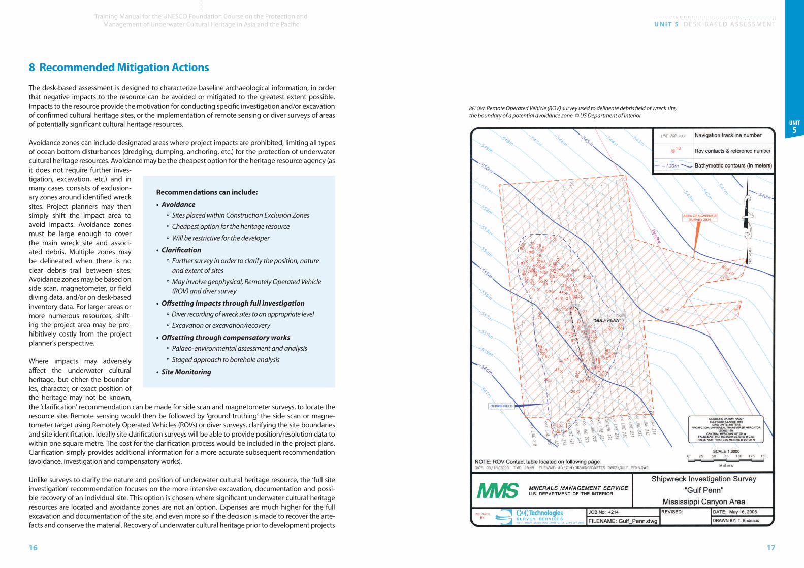
Offshore oil platform; risers, platform jackets, subsea pipelines and wellheads all potentially impact underwater cultural heritage resources. © NOAA Sanctuaries
Types of ocean development which have the potential to greatly affect the underwater cultural heritage include:
• Bottom dredging
• Trawling
• Wharf/port/marina development
• Offshore wind farms
• Oil and gas development
• Sub-sea cables and pipelines
• Wave power (in early stages of development)
• Outfalls (sewerage)
• Spoils (dredge materials) dumping
16
Training Manual for the UNESCO Foundation Course on the Protection and Management of Underwater Cultural Heritage in Asia and the Pacific U N I T 5 D E S K - B A S E D A S S E S S M E N T
17
Unit 5
8 Recommended Mitigation Actions
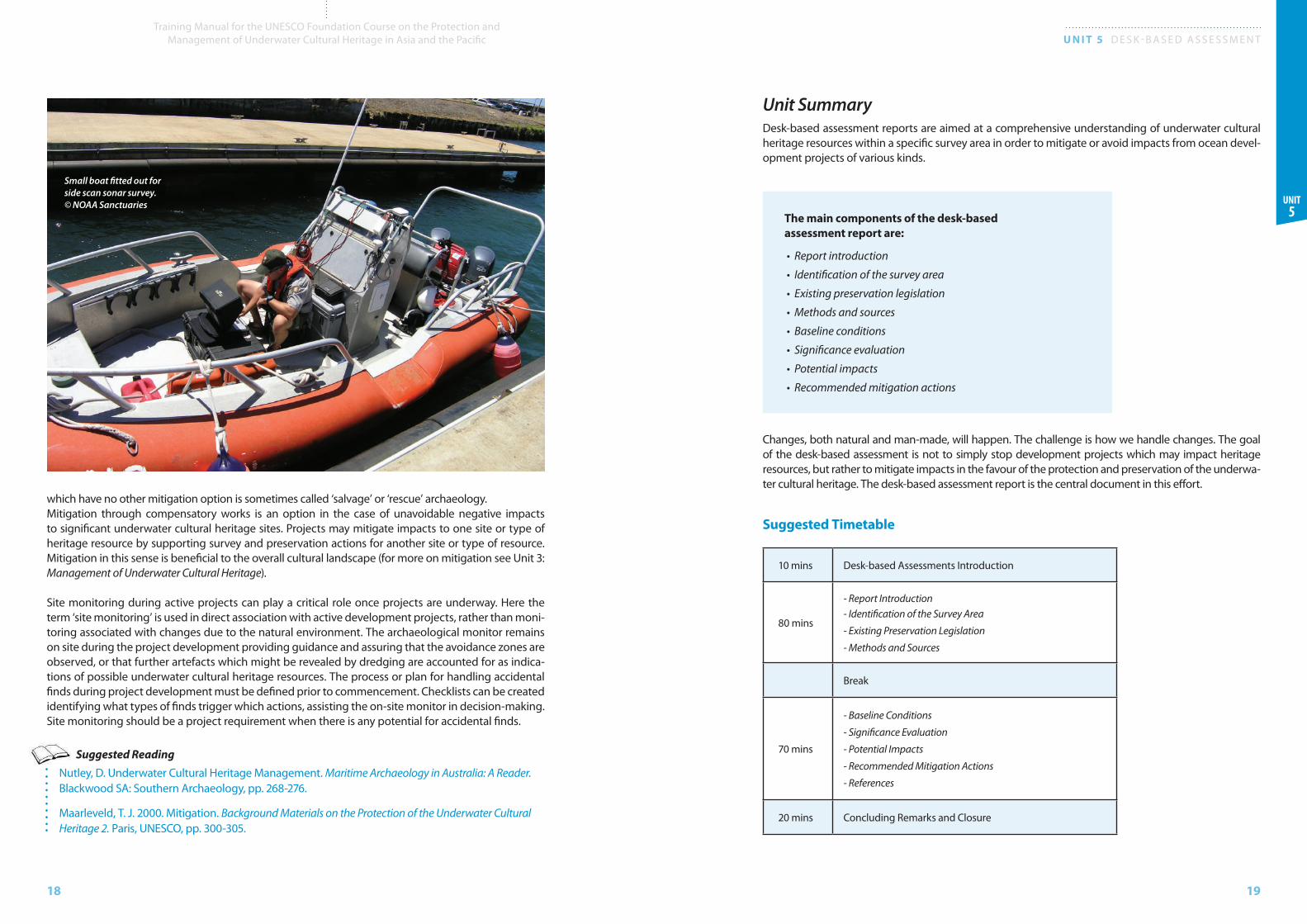
The desk-based assessment is designed to characterize baseline archaeological information, in order that negative impacts to the resource can be avoided or mitigated to the greatest extent possible. Impacts to the resource provide the motivation for conducting specific investigation and/or excavation of confirmed cultural heritage sites, or the implementation of remote sensing or diver surveys of areas of potentially significant cultural heritage resources.
Avoidance zones can include designated areas where project impacts are prohibited, limiting all types of ocean bottom disturbances (dredging, dumping, anchoring, etc.) for the protection of underwater cultural heritage resources. Avoidance may be the cheapest option for the heritage resource agency (as it does not require further inves-tigation, excavation, etc.) and in many cases consists of exclusion-ary zones around identified wreck sites. Project planners may then simply shift the impact area to avoid impacts. Avoidance zones must be large enough to cover the main wreck site and associ-ated debris. Multiple zones may be delineated when there is no clear debris trail between sites. Avoidance zones may be based on side scan, magnetometer, or field diving data, and/or on desk-based inventory data. For larger areas or more numerous resources, shift-ing the project area may be pro-hibitively costly from the project planner’s perspective.
Where impacts may adversely affect the underwater cultural heritage, but either the boundar-ies, character, or exact position of the heritage may not be known, the ‘clarification’ recommendation can be made for side scan and magnetometer surveys, to locate the resource site. Remote sensing would then be followed by ‘ground truthing’ the side scan or magne-tometer target using Remotely Operated Vehicles (ROVs) or diver surveys, clarifying the site boundaries and site identification. Ideally site clarification surveys will be able to provide position/resolution data to within one square metre. The cost for the clarification process would be included in the project plans. Clarification simply provides additional information for a more accurate subsequent recommendation (avoidance, investigation and compensatory works).
Unlike surveys to clarify the nature and position of underwater cultural heritage resource, the ‘full site investigation’ recommendation focuses on the more intensive excavation, documentation and possi-ble recovery of an individual site. This option is chosen where significant underwater cultural heritage resources are located and avoidance zones are not an option. Expenses are much higher for the full excavation and documentation of the site, and even more so if the decision is made to recover the arte-facts and conserve the material. Recovery of underwater cultural heritage prior to development projects
BELOW: Remote Operated Vehicle (ROV) survey used to delineate debris field of wreck site, the boundary of a potential avoidance zone. © US Department of Interior
Recommendations can include:
• Avoidance
° Sites placed within Construction Exclusion Zones
° Cheapest option for the heritage resource
° Will be restrictive for the developer
• Clarification
° Further survey in order to clarify the position, nature and extent of sites
° May involve geophysical, Remotely Operated Vehicle (ROV) and diver survey
• Offsetting impacts through full investigation
° Diver recording of wreck sites to an appropriate level
° Excavation or excavation/recovery
• Offsetting through compensatory works
° Palaeo-environmental assessment and analysis
° Staged approach to borehole analysis
• Site Monitoring
18
Training Manual for the UNESCO Foundation Course on the Protection and Management of Underwater Cultural Heritage in Asia and the Pacific U N I T 5 D E S K - B A S E D A S S E S S M E N T
19
Unit 5
which have no other mitigation option is sometimes called ‘salvage’ or ‘rescue’ archaeology. Mitigation through compensatory works is an option in the case of unavoidable negative impacts to significant underwater cultural heritage sites. Projects may mitigate impacts to one site or type of heritage resource by supporting survey and preservation actions for another site or type of resource. Mitigation in this sense is beneficial to the overall cultural landscape (for more on mitigation see Unit 3: Management of Underwater Cultural Heritage).
Site monitoring during active projects can play a critical role once projects are underway. Here the term ‘site monitoring’ is used in direct association with active development projects, rather than moni-toring associated with changes due to the natural environment. The archaeological monitor remains on site during the project development providing guidance and assuring that the avoidance zones are observed, or that further artefacts which might be revealed by dredging are accounted for as indica-tions of possible underwater cultural heritage resources. The process or plan for handling accidental finds during project development must be defined prior to commencement. Checklists can be created identifying what types of finds trigger which actions, assisting the on-site monitor in decision-making. Site monitoring should be a project requirement when there is any potential for accidental finds.
Suggested ReadingNutley, D. Underwater Cultural Heritage Management. Maritime Archaeology in Australia: A Reader. Blackwood SA: Southern Archaeology, pp. 268-276.
Maarleveld, T. J. 2000. Mitigation. Background Materials on the Protection of the Underwater Cultural Heritage 2. Paris, UNESCO, pp. 300-305.
Unit SummaryDesk-based assessment reports are aimed at a comprehensive understanding of underwater cultural heritage resources within a specific survey area in order to mitigate or avoid impacts from ocean devel-opment projects of various kinds.
The main components of the desk-based assessment report are:
• Report introduction
• Identification of the survey area
• Existing preservation legislation
• Methods and sources
• Baseline conditions
• Significance evaluation
• Potential impacts
• Recommended mitigation actions
Changes, both natural and man-made, will happen. The challenge is how we handle changes. The goal of the desk-based assessment is not to simply stop development projects which may impact heritage resources, but rather to mitigate impacts in the favour of the protection and preservation of the underwa-ter cultural heritage. The desk-based assessment report is the central document in this effort.
Suggested Timetable
10 mins Desk-based Assessments Introduction
80 mins
- Report Introduction- Identification of the Survey Area
- Existing Preservation Legislation
- Methods and Sources
Break
70 mins
- Baseline Conditions
- Significance Evaluation
- Potential Impacts
- Recommended Mitigation Actions
- References
20 mins Concluding Remarks and Closure
Small boat fitted out for side scan sonar survey. © NOAA Sanctuaries
20
Training Manual for the UNESCO Foundation Course on the Protection and Management of Underwater Cultural Heritage in Asia and the Pacific U N I T 5 D E S K - B A S E D A S S E S S M E N T
21
Unit 5
Teaching Suggestions
The Desk-based Assessment unit clarifies the role that document or archival based surveys play in the management of underwater cultural heritage resources, and provides students with guidance on com-pleting and presenting these critical assessments. Some teaching suggestions to enhance the student’s knowledge of some of the topics covered during this unit have been selected.
3 Existing Preservation LegislationThe trainer should ask the students to provide examples of underwater cultural heritage preservation laws from their own countries. These laws will be specific to individual nations and students are already likely to be familiar with them. Are these examples familiar to non-marine resource managers?
4 Methods and Sources
Recommended questions for discussion are:
• What other sources are unique to the students’ regions?
• What are the advantages and disadvantages of using obscure types of information?
• Should the resource manager offer money for heritage information (ethical debate)?
8 Recommended Mitigation ActionsIf students have access to information regarding their course training site, the trainer could utilize the master plan template from Appendix E: Management Plan for the Mannok Shipwreck Site and task the students with selecting and describing site assessment factors.
Suggested Reading: Full List
Bowens, Amanda (ed.). 2009. International and National Laws Relating to Archaeology Under Water. Underwa-ter Archaeology: The NAS Guide to Principles and Practice, Second Edition. Portsmouth, NAS, pp. 45-52.
Bowens, Amanda (ed.). 2009. Historical Research. Underwater Archaeology: The NAS Guide to Principles and Practice, Second Edition. Portsmouth, NAS, pp. 65-70.
Maarleveld, T. J. 2000. Archaeological heritage management: Cultural and Legislative Perspective. Background Materials on the Protection of the Underwater Cultural Heritage 2. Paris, UNESCO, pp. 204-217.
Maarleveld, T. J. 2000. Mitigation. Background Materials on the Protection of the Underwater Cultural Heritage 2. Paris, UNESCO, pp. 300-305.
Manders, M. 2004. Safeguarding a Site: The Master Management Plan. MOSS Newsletter. March 2004, pp. 16-19.
Muche, F. J. 1998. Site Location Factors. Maritime Archaeology: a Reader of Substantive and Theoretical Contribu-tions. New York, Plenum Press, pp. 253-255.
Negueruela, I. 2000. Managing Our Maritime Heritage: The Case of the National Maritime Archaeological Museum and National Centre for Underwater Research, Cartegena, Spain. Background Materials on the Protec-tion of the Underwater Cultural Heritage 2. Paris, UNESCO, pp. 280-297.
Nutley, D. Underwater Cultural Heritage Management. Maritime Archaeology in Australia: A Reader. Blackwood SA: Southern Archaeology, pp. 268-276.
Ruppe, R J. 1998. Sea Level Change as a Variable in Colonial American Archaeology. Maritime Archaeology: a Reader of Substantive and Theoretical Contributions. New York, Plenum Press, pp. 247-252.
Sundaresh, A.S. Guar. and Nair, R.R. 1997. Our Threatened Archaeological Heritage: A Case Study from the Tamil Nadu Coast. Current Science, Vol 73. No. 7, pp. 593-598.
UNESCO Information and Knowledge Management Unit. 2007. UNESCO Bangkok Style Guide for English language. Bangkok, UNESCO.
Viduka, A. 2006. Managing Threats to Underwater Cultural Heritage Sites: the Yongala as a Case Study. Under-water Cultural Heritage at Risk: Managing Natural and Human Impacts, pp. 61-63.