Embed Size (px)
DESCRIPTION
A collection of my work while studying Landscape Architecture at the University of Georgia
Citation preview

Cover page: Live Oaks drawn in colored pencil, enhanced with Photoshop

“To design responsibly in such a landscape one must view
history less as a ‘past’ which can be dammed, than a stream one alters when one steps in”
John McKean

00
01. 0203. 04
05. 06
07. 0809. 10
11. 1213. 1415. 16
17. 18
19. 20
21. 22
23. 2425. 26
27. 28
29. 3031. 3233. 34
Contents
Residential Graphics ProcessSections and Axonometric Illustration
Highway Median
Residential Planting DesignPark Entrance Planting Plan
Stream RestorationTanyard CreekStormwater Management
Sensory Recreational Trail
Veterans Memorial Garden- Campus DesignPlanting Plan & Construction Details
Community ParkPublic Health & Design
Broad St. Market
Design StudiesStudy AbroadArtwork
Contents
Process
Roadway Beautification
Horticulture
Ecology ->Water Reclamation
Recreational Design
Document Impletation
Get Outside & Play!
Commercial DesignInspiration
Miscellaneous

[email protected] Watercolor Painting from Photo00

Duncan Residence: Concept & Master Plan (ink on vellum)
Resi
dential
Desi
gn P
rocess

Section/Elevation in
watercolor
Final inwatercolor
Duncan Residence: Concept & Master Plan (ink on vellum)
Resi
dential
Desi
gn P
rocess

Hig
hw
ay M
edia
n
Highway Median Along Atlanta Highway. Athens, GA
Listening to a variety of music with pastels in hand, I created a combination of flowing colors to work from. I really enjoyed Louis Armstrong’s very upbeat, fast paced music that caters to a twirling, high stepping dance movement. “ Mahogany Hall Stomp” & “That Rhythm Man” inspired naturalistic, moving
forms, an earth tone planting base & a serpentine fence. The gold mesh fence is reminiscent of the glitzy 1920’s along with
the music notes & bars of Armstorng’s scoresheet.
Courtsey of Google Maps. existing median on
Atlanta Highway.
A A1

Resi
dential
Pla
nting D
esi
gn
Christmas Residence Master Plan

Pla
ntin
g S
ectio
ns &
Ele
vatio
ns
My client expressed his desire to have a patio to entertain his guests. I thought the solution was a garden that contained plants that he and his family could use and tend to throughout the year. He wanted a yard that was safe for his children to play in and a place with enough privacy that his location as a corner house could be forgotten.

Park E
ntr
ance P
lanting
Clayton County Parks & Recreation, GA
Quercus nigra
Existing Water Oak 32’ Dia
(9) Lagerstroemia indica
Crape Myrtle (3” caliber @ 9’ o.c.)
(7) Prunus laurocerasus ‘Otto
Otto Luyken Laurel (1 gal @ 5’ o.c.)
Park Entrance sign
2’ x 12’
(10) Vinca minor
Periwinkle (1 1/2” pot @ 24” o.c.)
Pinus Spp
Pine Straw, apply as needed
(7) Hosta Spp
Hosta (1/2 gal pot @ 3’ o.c.)
(7) Sarcococca confusa
Sweet Box (2 gal pot @ 5’ o.c.)
(13) Pennisetum setaceum ‘Rubrum’
Purple Fountain Grass (1 gal @ 4’ o.c.)
(11) Solenostemon scutellarioides (Coleus x hybridus)Coleus (11/2” pot @ 2’ o.c.)
(25) Begonia grandis (evansiana)
Begonia ( 1 1/2” pot @ 12” o.c.)
Prunus laurocerasus ‘Otto Luyken’
Otto Luyken Laurel (1 gal @ 5’ o.c.)
(3) Pennisetum setaceum ‘Rubrum’
Purple Fountain Grass (1 gal @ 4’ o.c.)
(9) Solenostemon scutellarioides (Coleus x hybridus)
Coleus (1 1/2” pot @ 2’ o.c.)
(15) Angelonia angustifolia “Serena Lavender’Lavender Serena Summer Snapdragon (1 1/2” pot @ 12” o.c.)
Quercus nigraExisting Water Oak, 15’ Dia
Quercus nigra
Existing Water Oak, 10’ Dia
Quercus nigraExisting Water Oak, 32’ Dia
(3) Magnolia stellataStar Magnolia(2” caliber @ 9’ o.c.)
(2) Calycanthus floridus
Sweetshrub(2 gal @ 5’ o.c.)
(2) Viburnum rhytidophyllumLeatherleaf Viburnum (3 gal pot @ 15’ o.c.)
Fla
t S
hoals
Park
1915
Fla
t S
hoals
Rd
Riv
erdale
, GA
30296
05
Base Map
Cla
yto
n C
ounty
Parks &
Rec
reatio
nA
rchw
ay P
artn
ersh
ip Sum
mer
20
11
Amelia KanePlanting Designs for Clayton County Parks
Pla
nt S
am
ple S
heet
Viburnum rhytidophyllum Leatherleaf Viburnum
Liriope muscari Liriope
Dianthus barbatusDianthus
Trachelospermum asiaticum Asian Jasmine
Cornus florida Flowering Dogwood
Geranium "blue Sunrise' Blue Sunrise Crane's
Rhododendron eriocarpum Satsuki Azalea
Angelonia angustifolia Summer Snapdragon
Magnolia stellata Star Magnolia
Rhaphiolepis umbellata Indian Hawthorn
Begonia grandisBegonia
Calycanthus florida Sweetshrub
Solenostemon scutellarioides Coleus
Cotinus coggygria Smoketree
Kerria japonica “Pleniflora’ Kerria, Japanese Rose
Dryopteris erythrosora Autumn Fern
Pennisetum setaceum ‘Rubrum’ Purple Fountain Grass
Betula nigraRiver Birch
Lagerstroemia indica Crape Myrtle
Hosta SpeciesHosta
Lantana camaraLantana
Prunus LaurocerasusOtto Luyken Laurel
Loropetalum chinenseLoropetalum
Ophiopogon japonicusMondo Grass
Daphne odora Winter Daphne
Vinca minorPeriwinkle
Quercus nigraWater Oak
P. axillarisWhite Petunia
x Cupressocyparis leylandiiLeyland Cypress
03

09
Sig
n E
xam
ples
All work done for Ricardo NewmanSources:Google MapsClayton County Parks & Recreation 2008 ReportBooz Allen Hamiliton AssociatesOdenwald, Neil G. & James r. Turner: Identification,Selection and Use of Southern Plants
Watercolor of proposed Independence Park Sign
Photoshop example of proposed Flat Shoals Park Sign
The two examples of the new signage are meant to illustrate how important color is within a landscape. The variety of color attracts the eye and encourages those passing by to venture inside the park. The seasonal plantings accent the entrance sign and highlight the entryway, making each park unique and recognizable to patrons.
Pla
nt S
am
ple S
heet
Viburnum rhytidophyllum Leatherleaf Viburnum
Liriope muscari Liriope
Dianthus barbatusDianthus
Trachelospermum asiaticum Asian Jasmine
Cornus florida Flowering Dogwood
Geranium "blue Sunrise' Blue Sunrise Crane's
Rhododendron eriocarpum Satsuki Azalea
Angelonia angustifolia Summer Snapdragon
Magnolia stellata Star Magnolia
Rhaphiolepis umbellata Indian Hawthorn
Begonia grandisBegonia
Calycanthus florida Sweetshrub
Solenostemon scutellarioides Coleus
Cotinus coggygria Smoketree
Kerria japonica “Pleniflora’ Kerria, Japanese Rose
Dryopteris erythrosora Autumn Fern
Pennisetum setaceum ‘Rubrum’ Purple Fountain Grass
Betula nigraRiver Birch
Lagerstroemia indica Crape Myrtle
Hosta SpeciesHosta
Lantana camaraLantana
Prunus LaurocerasusOtto Luyken Laurel
Loropetalum chinenseLoropetalum
Ophiopogon japonicusMondo Grass
Daphne odora Winter Daphne
Vinca minorPeriwinkle
Quercus nigraWater Oak
P. axillarisWhite Petunia
x Cupressocyparis leylandiiLeyland Cypress
03
Pla
nt S
am
ple Sheet
Viburnum rhytidophyllum Leatherleaf Viburnum
Liriope muscari Liriope
Dianthus barbatusDianthus
Trachelospermum asiaticum Asian Jasmine
Cornus florida Flowering Dogwood
Geranium "blue Sunrise' Blue Sunrise Crane's
Rhododendron eriocarpum Satsuki Azalea
Angelonia angustifolia Summer Snapdragon
Magnolia stellata Star Magnolia
Rhaphiolepis umbellata Indian Hawthorn
Begonia grandisBegonia
Calycanthus florida Sweetshrub
Solenostemon scutellarioides Coleus
Cotinus coggygria Smoketree
Kerria japonica “Pleniflora’ Kerria, Japanese Rose
Dryopteris erythrosora Autumn Fern
Pennisetum setaceum ‘Rubrum’ Purple Fountain Grass
Betula nigraRiver Birch
Lagerstroemia indica Crape Myrtle
Hosta SpeciesHosta
Lantana camaraLantana
Prunus LaurocerasusOtto Luyken Laurel
Loropetalum chinenseLoropetalum
Ophiopogon japonicusMondo Grass
Daphne odora Winter Daphne
Vinca minorPeriwinkle
Quercus nigraWater Oak
P. axillarisWhite Petunia
x Cupressocyparis leylandiiLeyland Cypress
03
Entr
ance S
ign E
xam
ples

Research*Speak with University Architects about development/research of Tanyard Creek*Read Historical Maps and accounts of Tanyard Creek* Taylor and Dr. Lee teach us the ways of GIS. We are AMAZED! * Document the orientation of the creek *Find EPA tests on the quality of the creek
Site Visits* Explore direction of creek and see each place where creek is placed underground* Walk from Ben’s Bikes to the Cem-etery behind Stanford Stadium looking at different sections of the creek and its aquatic life* Take notes on vegetation-> many invasive species, but also many beautiful vegetated areas as well*Learn that waterway has been treated as a nuisance, not a valued aesthetic* See areas of creek that pretty smelly and very poor water quality
tanyard c
reek.
Research P
rocess
Research*Speak with University Architects about development/research of Tanyard Creek*Read Historical Maps and accounts of Tanyard Creek* Taylor and Dr. Lee teach us the ways of GIS. We are AMAZED!* Document the orientation of the creek*Find EPA tests on the quality of the creek
Zach discovers areas to place goats in the near future-> speaks with Sustainability Department. Learns of future Green Campus plans and incorporation Tanyard Creek
Collaboration*Illustrate findings through photos, field notes and research* Make suggestions for restoration , preservation and new development
Courtesy of Tanyard Branch Restoration & Design StudioSummer 2002
02.
Str
eam
Rest
oration
Tanyard Creek Project- C. Hale, H, Johnson, A. Kane, Z. Richardson
Site Visits* Explore direction of creek and see each place where creek is placed underground* Walk from Ben’s Bikes to the Cemetery behind Stan-ford Stadium looking at different sections of the creek and its aquatic life* Take notes on vegetation-> many invasive species, but also many beautiful vegetated areas as well*Learn that waterway has been treated as a nuisance, not a valued aesthetic* See areas of creek that have a petrid smell and very poor water quality
Speak with Sustainability Department @ UGA. Learn of future Green Campus plans and incorporation of Tanyard Creek
Collaboration*Illustrate findings through photos, field notes and research* Make suggestions for restoration, preservation and new development
Courtesy of Tanyard Branch Restoration & Design StudioSummer 2002
Inventory and Analysis

GIS
file o
f Tanya
rd C
reek
EPA FindingsTanyard Creek at East Campus Drive Athens, GeorgiaActivity Type: Field Msr/ObsMedium: Water
Characteristic Measure Dissolved oxygen (DO) 7400 (ug/l) pH 6.9 Specific conductance 179 (uS/cm) Temperature, water 20 (deg C) Fecal Coliform 1400 (MPN) Specific conductance 114 (uS/cm) Temperature, air 21 (deg C) Barometric pressure 740 (mmHg)
12

Tanya
rd C
reek
Desi
gn Im
plem
enta
tion
Tanyard Creek Project- A. Kane, J. Stephens, C. Vitulli
Gabion Walls are an excellent way help stablize extreme slopes along the stream bank. Gabion walls are simple to construct
and do not require the work of an expert to build. They may be built on a community volunteer weekend, supplies coming from the local junkyard and rocks
from the creek bed. The gabion walls allow us to avoid exca-vating the creek bank into the Ben’s Bike parking lot, and cre-ate an unique aesthetic to the
stream.Live Staking is another way of stablizing the slope. It is a low cost solution, using recycled tree branches tied together
with twine to create fascines which control erosion.

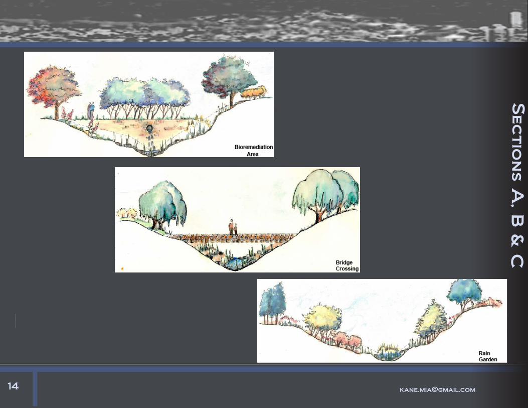
raised path
Sto
rm
wate
r M
anagem
ent
Master Plan Above. Pen and Colored Pencil. Collaboration with Hattie Johnson
Drainage & Grading Proposal
Numerous days of walk-ing to and from class were spent avoiding flooded path-
ways and eroded gravel-stones. My colleague and I proposed a retention pond, so that the water could
be collected, filtered and slowly released back into
the existing watershed.
pipe from storm drain
retention pond
flattened field

shallow slope to encourage
amphibian habitat
banks fringed with tall grasses or
rushes to provide cover and food
25 cm
shelf with marginal plants
that provide cover and food
steep slope to support burrow systems
Section/ Elevation of Plan
Cross Section of Retention PondAL1
Rete
ntio
n P
ond

Senso
ry R
ecreational
Multi- Sensory Trail Design. UGA Campus, Costa Rica
The beautiful additional exit of
the comedor.
Proposed outdoor seating area with veranda covered
patio to collect water.

Trail D
eta
ils
Water Collection Illustration
Railing and Log
Barrier Sketch
Heliconia:Part of the
Sensory Garden
Strangler Fig on Trail

Vete
rans
Memoria
l G
arden
University of Georgia Campus- Illustrative Master Plan

College o
f E
nvir
onment &
Desig
nU
niv
ersit
y o
f G
eorgia
LAN
D 4
380- S
pooner
Dim
ensio
ns &
Stakin
g P
lan
Revisions
Name: Date:
Issue Date:Oct.4th, 2011
Drawn by:Amelia Kane
Checked by:Prof. Spooner
RegistrationSeal
Scale: 1"= 10'00"
North Arrow.png
Sheet contents:Staking PlanDimensionsMaterials
Sheet #
l4
A. Kane Designs
Grading Plan
•• Grading Plan is prepared on a base survey prepared by a professional surveyor
•• All existing and propsosed elevations are shown on this plan
•• All existing features are shown with thin and/ or screen lines
•• Existing spot elevations are shown in boxes
PRO
DU
CED
BY
AN
AU
TOD
ESK
ED
UC
ATI
ON
AL
PRO
DU
CT
PRODUCED BY AN AUTODESK EDUCATIONAL PRODUCT
PRO
DU
CED
BY A
N A
UTO
DESK
EDU
CA
TION
AL PR
OD
UC
T
PRODUCED BY AN AUTODESK EDUCATIONAL PRODUCT
Gradin
g P
lan

Pla
nting P
lan
All work done in AutoCAD & Excel
College o
f E
nvir
onment &
Desig
nU
niv
ersit
y o
f G
eorgia
LAN
D 4
380- S
pooner
PLAN
TIN
G P
LAN
Revisions
Name: Date:
Issue Date:Oct.18, 2011
Drawn by:Amelia Kane
Checked by:Prof. Spooner
RegistrationSeal
Scale: 1"= 10'00"
North Arrow.png
Sheet contents:Planting plan &schedule
Sheet #
l5
A. Kane Designs
PRO
DU
CED
BY
AN
AU
TOD
ESK
ED
UC
ATI
ON
AL
PRO
DU
CT
PRODUCED BY AN AUTODESK EDUCATIONAL PRODUCT
PRO
DU
CED
BY A
N A
UTO
DESK
EDU
CA
TION
AL PR
OD
UC
T
PRODUCED BY AN AUTODESK EDUCATIONAL PRODUCT

Constr
uctio
n D
eta
ils
22
College o
f E
nvir
onment &
Desig
nU
niv
ersit
y o
f G
eorgia
LAN
D 4
380- S
pooner
Constructio
n D
etail
s
Revisions
Name: Date:
Issue Date:Nov. 2, 2011
Drawn by:Amelia Kane
Checked by:Prof. Spooner
RegistrationSeal
Scale: 1"= 1'00"
North Arrow.png
Sheet contents:Planting plan &schedule
Sheet #
l6
A. Kane Designs
8" 4'
5"8"
3'-1
"
6"
1'
7"
1'
6"
2'-6
"4"
5"
9"
1'-5"
1"
1'-1"
1"
6"
4"
1'
6"
2'-4"
8"
9"
Stair & Reflection Pool Section
Scale: 1"= 1' 00"
a.l6
Tree Planting, Brick on Sand & Retaining Wall Section
Scale: 1"= 1' 00"
b.l6
PRO
DU
CED
BY
AN
AU
TOD
ESK
ED
UC
ATI
ON
AL
PRO
DU
CT
PRODUCED BY AN AUTODESK EDUCATIONAL PRODUCT
PRO
DU
CED
BY A
N A
UTO
DESK
EDU
CA
TION
AL PR
OD
UC
T
PRODUCED BY AN AUTODESK EDUCATIONAL PRODUCT

Design Process of Neighborhood Playground
PER
SPE
CT
IVE
S
Perspective 1 The perspective of the slide is located behind the formal play area. It takes advantage of the existing topography by have the slide en-bedded in the hill. The boulders to the left of the slide cater to climbing and exploring. (p1 on master plan)
Perspective 2 The perspective begins with the pathway to the community garden leading from the formal play area. The pathway is made up of stones embedded in an earthen floor. The bride is made of wood and stands over a detention pond. Al-though little water will be collected, the pond area still serves as a tool for education and play.(p2 on master plan)
07.
REE
SE
HIS
TO
RIC
DIS
TRI
CT
:
A P
LAY
GRO
UN
DLA
ND
4912
- DR.
LE
EFA
LL 20
11 P
ROJE
CT
3
AM
ELI
A K
AN
E
SiteSelection
Playground
LoosePlay
Education
PhysicalActivity
Formal vsLoose
ReeseHistoricDistrict
Community Garden
Residence
Wooded Area
Formal Area
Structures
Sidewalk
Barrier Needed
Church
Movement
Site Selection:
B
B1
A A1
ENTRANCE
Brick Area de-noting key dates and people from the Reese Histoirc District
Lawn Area leading to slide down the hill
Boulders to climb
Seat Wall
WoodedArea
Pathway to Community Garden
Detention pond: area to play with water, plants and rocks
Bamboo
3’ wall for drawing
Open , 2 story house structure
Wooded play structure
Area with wooded logs and blocks for free building
Bridge
Open Lawn for games
Open field for planting or digging
Pergola with hanging balls
Tree Branch Fence
Music maing area Pope
Street
A1
B
B1
P2
APope Street
NTS
The site was selected because of its ease of access, its walkability and its topography. The site is fairly flat for roughly 50 feet beginning at the edge of the sidewalk. To take advantage of the range of topo, a formal concrete, stone and brick area is proposed for the formal area. This area will allow for games such as jump rope, hop scotch and chalk and painting. The edge of this area will pro-vide a seat wall for those adults that have come to watch their children. They can have a moment to relax and let the children play on their own- allowing for social interactions to be worked out by the children and imaginative play to flourish.
The Community Park & Playground allows for adult and child to enjoy the outdoors together or sepa-raptely. The park allows for a variety of activites and en-courages children to discover their own ways to play out-side. Through climbing structures, movable tree longs, mud piles and non- toxic plants throughout the site,kids can obtain social skills through learning to share and playing with others.The formal play area allows for the adults to sit back and watch, while keeping a distant eye on their children.
The entrance to the park is a teepee like structure made up of flowering vines. The scale of the entrance caters to children because of the variance of scale. The brick area following the entrance has significant dates, people and places of the Reese Historic District, al-lowing the children to indirectly take part in a history lesson. The formal play area is made up of concrete that encourages chalk drawings and games that require a level surface such as four square, hop scotch and jump rope. The rest of the playground is made up of open and wooded areas, with various wooden structures throughout. This area allows for a great amount of loose, imaginative play that have proven to be essential to the development of a healthy child.
B
TH
OU
GH
T P
RO
CE
SS
SiteSelection
Playground
LoosePlay
Education
PhysicalActivity
Formal vsLoose
ReeseHistoricDistrict
The site was selected because of its ease of access, its walkability and its topography. The site is fairly flat for roughly 50 feet beginning at the edge of the sidewalk. To take advantage of the range of topo, a formal concrete, stone and brick area is proposed for the formal area. This area will allow for games such as jump rope, hop scotch and chalk and painting. The edge of this area will pro-vide a seat wall for those adults that have come to watch their children. They can have a moment to relax and let the children play on their own- allowing for social interactions to be worked out by the children and imaginative play to flourish.
Community Garden
Residence
Wooded Area
Formal Area
Structures
Sidewalk
Barrier Needed
Church
Movement
Seating
Design Process:
Bubble Diagram
Concept Diagram
03.
Com
munity P
ark
This is the existing topo in
the Reese Historic
District, Athens GA. The park is meant to gather
adults and children alike,
allowing history to be learned and games to be
played.

MA
ST
ER
PLA
N w
ith L
AB
ELS
ENTRANCE
Brick Area de-noting key dates and people from the Reese Histoirc District
Lawn Area leading to slide down the hill
Boulders to climb
Seat Wall
WoodedArea
Pathway to Community Garden
Detention pond: area to play with water, plants and rocks
Bamboo
3’ wall for drawing
Open , 2 story house structure
Wooded play structure
Area with wooded logs and blocks for free building
Bridge
Open Lawn for games
Open field for planting or digging
Pergola with hanging balls
Tree Branch Fence
Music maing area, Sketch C
Pope StreetA
A1
BB1
Sketch B
P2
Sketch A
P1
05.
REES
E H
ISTO
RIC D
ISTR
ICT:
A PL
AYGR
OUND
LAND
4912-
DR.
LEE
FALL
2011
PROJ
ECT 3
AME
LIA K
ANE
SiteSelection
Playground
LoosePlay
Education
PhysicalActivity
Formal vsLoose
ReeseHistoricDistrict
Community Garden
Residence
Wooded Area
Formal Area
Structures
Sidewalk
Barrier Needed
Church
Movement
Site Selection:
B
B1
A A1
ENTRANCE
Brick Area de-noting key dates and people from the Reese Histoirc District
Lawn Area leading to slide down the hill
Boulders to climb
Seat Wall
WoodedArea
Pathway to Community Garden
Detention pond: area to play with water, plants and rocks
Bamboo
3’ wall for drawing
Open , 2 story house structure
Wooded play structure
Area with wooded logs and blocks for free building
Bridge
Open Lawn for games
Open field for planting or digging
Pergola with hanging balls
Tree Branch Fence
Music maing area Pope
Street
A1
B
B1
P2
APope Street
NTS
The site was selected because of its ease of access, its walkability and its topography. The site is fairly flat for roughly 50 feet beginning at the edge of the sidewalk. To take advantage of the range of topo, a formal concrete, stone and brick area is proposed for the formal area. This area will allow for games such as jump rope, hop scotch and chalk and painting. The edge of this area will pro-vide a seat wall for those adults that have come to watch their children. They can have a moment to relax and let the children play on their own- allowing for social interactions to be worked out by the children and imaginative play to flourish.
The Community Park & Playground allows for adult and child to enjoy the outdoors together or sepa-raptely. The park allows for a variety of activites and en-courages children to discover their own ways to play out-side. Through climbing structures, movable tree longs, mud piles and non- toxic plants throughout the site,kids can obtain social skills through learning to share and playing with others.The formal play area allows for the adults to sit back and watch, while keeping a distant eye on their children.
The entrance to the park is a teepee like structure made up of flowering vines. The scale of the entrance caters to children because of the variance of scale. The brick area following the entrance has significant dates, people and places of the Reese Historic District, al-lowing the children to indirectly take part in a history lesson. The formal play area is made up of concrete that encourages chalk drawings and games that require a level surface such as four square, hop scotch and jump rope. The rest of the playground is made up of open and wooded areas, with various wooden structures throughout. This area allows for a great amount of loose, imaginative play that have proven to be essential to the development of a healthy child.
B
Pla
yground P
ropo
sal

Public H
ealt
h &
Desi
gn
Examining CDC’s SafeRoutes & Food Security
0.00%
5.00%
10.00%
15.00%
20.00%
25.00%
1975 1980 1985 1990 1995 2000 2005 2010 2015
Percentage
Years
Statistics of Childhood Obesity
Ages 6-11
Ages 12-19
•Provide incentives to existing supermarkets and farmers’ markets to establish their businesses in low-income areas or to sell healthier foods.•Expand programs that bring local fruits and vegetables to schools.•Increase access to free drinking water and limit the sale of sugar drinks in schools by establishing school wellness and nutrition policies.•Create and maintain safe neighborhoods for physical activity and improve access to parks and playgrounds.•Support quality daily physical education in schools.
Childhood ObesityChildhood obesity has more than tripled in the past 30 years. The prevalence of obesity among children aged 6 to 11 years increased from 6.5% in 1980 to 19.6% in 2008. The prevalence of obesity among adolescents aged 12 to 19 years increased from 5.0% to 18.1%. Obesity is the result of caloric imbalance (too few calories expended for the amount of calories consumed) and is mediated by genetic, behavioral, and environmental factors. Assessing retail
food environment to better under-stand the current landscape and dif-ferences in acces-sibility to healthier foods. The GIS Food Des-ert map shows the percent of people who have low access to healthy foods. Athens, GA has 59.6% of people who are in the low-access cat-egory meaning it is very difficult to get to a grocery store, because of its proximity (> 1 mile) and they have limited use of a car and public transportation. http://www.cdc.gov/obesity/childhood/so-lutions.html

Broad S
t. M
arket
Abandoned Parking Lot Revitilization. Athens, GA
Corrected Construction Plan
Rendered by hand with Ink
Final Illustrative PlanInk, color pencil, &
watercolor

Broad S
t. Market
Basic Interior Floor Plan
Perspective of Interior of Farmer’s Market
Perspective of waterfeature &
plaza
Section/ Elevation looking West

Desi
gn S
tudie
s
Pathway Observations & Illustrations
Analysis of paths taken
from downtown Athens to
North Campus: Observing barriers,
nodes, pace and sounds
Analysis of Allegheny
Riverfront by Michael Van Valkenberg &
Associates. Examined textures, style, usage, and prolem solving

[email protected] Art study & Book binding
Desig
n S
tudie
s
Front Cover of
Photo Analysis Book
Light Analysis
Existing Photo
Mass Vs Void
Fore/Middle/Back Ground
Texture
Positive Vs Negative
Watercolor

Cost
a R
ica
Fall 2010 Study Abroad Program; UGA CR, San Luis
Photography from Costa Rica Study AbroadFall 2010

Stu
dy A
broad
32
One touch of nature makes the whole world kin.
William Shakespeare

Artw
ork
Paintings & Drawings in Pencil and Watercolor