Embed Size (px)
Citation preview

UAV Imagery and Data Management
for Precision Agriculture
John NowatzkiExtension Ag Machine Systems Specialist
North Dakota State University

• NDSU UAS & Sensing Activities
• Digital Data Management Issues
• Future of Digital Data in Agriculture
UAS in Precision Agriculture

Precision Agriculture & Data Management
• Computer Software
• Commercial Services
• Big Data
Telematics

Data in Precision Agriculture
Soil Map
Yield
Soil
Elevation
Imagery
Fertilizer Application Map
Seeding Application Map
Scouting Map
Chemical Application Map
Aerial, Satellite & UAS Imagery
Aerial Imagery

GPS
RTK GPS
Section Control on Sprayers
Row Control on Planters
Section Control on Air Seeders
Yield Monitors on Combines
Variable Hybrid Seeding
Variable Rate Seeding
In-season Fertilization
In-field Sensors
Zone Management in Fields
Drones in Ag
Imagery for Crop Management
96%
46%
81%
55%
20%
83%
20%
49%
4%
35%
15%
40%
29% Precision AgTechnologies
in North Dakota

• S
NDSU UAS Activities
Small and Large UAV
Trimble UX5
Phantom 3

UAS
Platforms
Trimble UX5
3DR RTF X8
RF70 - Troybuilt
Altavian
Phantom 3 & 4
https://www.ag.ndsu.edu/agmachinery
Hermes 450
DJI 1000A
DJI 100 Matrice

UAS
Sensors
Cameras• GoPro Camera
• ICI 9640 S Thermal camera
• Large area scanning EO/IR/NIR camera
• Sony NEX-5R camera with NIR
• Tetracam ADC
• Sentera dual sensor (4 band)
• Sentera Quad sensor (6 band)
• MicaSense Rededge
• Ximera Hyperspectral sensor
• Rikola Hyperspectral sensor
Sentera
Sony NEX-5R
Elbit EO/IR
Thermal
Hyperspectral
Rikola
ICI 9640
Ximea
410 - 950 nm
SlantRange

Roboflight RF-70

Phantom Quad Sensor
– 4 Cameras in One

• Pix4Dmapper
• Agisoft Photoscan Pro
• UnscramblerX
• SlantView
• Rikola Hyperspectral Imager
• ArcMap
• ERDAS Imagine
• ENVI
• Matlab
• QGIS
• SMS Spatial Management Systems
Image Processing Software

Imagery in May, June, July and August
• Color, Infrared Sensor
• 4,000, 6,000 and 8,000 ft
Small UAS, Satellite, Ground and Yield Data
All Imagery Securely Stored on NDSU Computers
Large-scale UAS Project
Objectives
Uses for Crop Management
Economic Value to Producers

Project Location – Eastern ND

Project Location – Eastern ND

Hermes 450 UAS

Hermes 450 UAS – Control Center

First Large UAS Civilian Flight in United States

Landing the Hermes 450

View from CAP Chase Plane

Data Management
Large UAS – Entire Corridor Each Date
Total Quantity of Imagery Collected during the Project: 10.5 TBPlus Small UAS Imagery
Plus Image Analyses
Date May 23-27
June 20-24 July 18-22
August 15-19
Altitude 4,000’ 6,000’ 8,000’
6,000’ 8,000’
6,000’ 8,000’
4,000’
8,000’
Image Quantity
Total Size
2.0 TB1.5 TB0.5 TB4.0 TB
1.5 TB0.5 TB2.0 TB
1.5 TB0.5 TB2.0 TB
2.0 TB
0.5 TB2.5 TB

• One North Dakota Field – 320 Acres, 2.45 GB– Transfer Time from NDSU Secure File Site
2 minutes – Grand Forks Courthouse – Wired Connection
4 minutes – Fargo Home – CableOne & Wireless
7 minutes - Fargo Home – CableOne & Wireless
9 minutes – Carrington Home – Cable & Wireless
10 minutes – Cass County Courthouse – Wireless
27 minutes – Richland County Courthouse
53 minutes – Griggs County Courthouse
1 hour and 10 minutes – NDSU CREC
Data Transfer Issues

NDSU Extension Role• Facilitate
• Collaborate
• Educate

May Imagery: 4,000’ – 6,000’ – 8,000’
4,000’
6,000’
8,000’
Detailed Imagery
- 50,000 Acres/Hour

Digital Elevation Model Using Large UAV

Sunflower Stand 2017 – Skips and Doubles

Corn Imagery: May – June – July - August

NDVI Trimble with
MicaSense Camera
Mapping IDC in Soybeans

NDVI Trimble with
MicaSense Camera
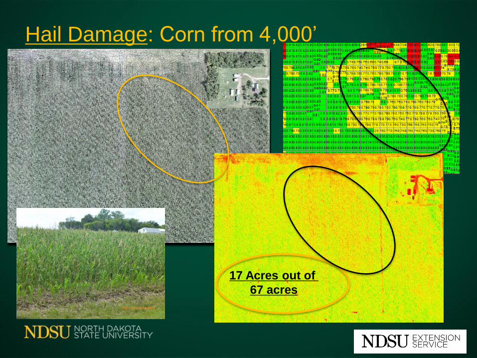
Hail Damage: Corn from 4,000’
17 Acres out of
67 acres

Cattle in August Imagery: 4,000’

~ 40 Acres
Imagery 4,000’
RGB Image
4 cm Pixel Size

Imagery Issues: Time Between Images

Imagery Issues: Time Between Images
Color Image

Imagery Issues: Time Between Images
NDVI Image
NDVI Mean=0.4975
NDVI Mean=0.6514

Identifying Volunteer Soybeans in Dry Beans Fields

Identifying Noxious Weeds
Slantrange
Camera

Identifying Herbicide-resistant Weeds

Identifying Herbicide-resistant Weeds
#1 Herbicide-resistant
Cooler
#2 Herbicide-susceptible
2-5 degrees warmer

Robotic Probe

Future of Data in Agriculture
• More In-field Sensors
• More Machine Sensors
• More Remote Sensing
• More UAVs
• More Robots
One More Layer for Big Data Precision Agriculture

Questions - Comments
Office 701-231-8213 Cell 701-261-9842
http://www.ag.ndsu.edu/agmachinery

Managing Large Amounts of
Digital Data
for Precision Agriculture
John Nowatzki
Agriculture and Biosystems Engineering
Kim Owen
Information Technology Division

Discovery and Innovation
critical implications for
R&E network infrastructure

Data transfer and storage ~
• By nature, production ag occurs in rural / remote areas, likewise the data for initiatives like this will originate in those same locations.
• To use the data for analysis, discovery and innovation, the data must travel or at least be accessible to experts from a distance.

Data privacy and security ~ • Grower privacy protect the grower’s crop production
and business related data while ensuring timely access to key research data sets by partners.
• Intellectual Property allow universities to patent
research discoveries and transfer the patent to the private sector.
• Research transparency and replicability ensures
attention to data privacy concerns is rigorous, but does not stifle progress of public/private research initiatives intended to benefit global society and economy.

Emphasizing the R&E role ~
[State & Regional networks] • provide access to scalable operating cyberinfrastructure
models for effective and dynamic delivery of computational resources and services to geographically distributed researchers.
• proximity to their campus members and familiarity with regional priorities and interests… provide focus on challenges and opportunities characteristic of the region …promote new capabilities and resources external to individual campuses.
(Monaco et al., 2016)

Implications for the Midwest Big Data Hub
Project Vision
Develop coordinated efforts by the academic, industrial and governmental sectors to automate Big Data lifecycles, improve access to data assets, and train a workforce with relevant skills and expertise, all contributors to solving sustaining global food security concerns.
Big Data Spoke
Digital Agriculture ~ Unmanned Aircraft
Systems, Plant Sciences and Education

References
Monaco, G.E., McMullen, D.F., Huntoon, G., Leasure, J., Swanson, D., Neeman, H., Blake, J., Adams, K. (2016). The role of regional organizations in improving access to the national computational infrastructure.
Retrieved online: https://www.researchgate.net/publication/304628611_The_Role_of_Regional_Organizations_in_Improving_Access_to_the_National_Computational_Infrastructure_A_Report_to_the_National_Science_Foundation