Embed Size (px)
Citation preview
U. S. DEPARTMENT OF COMMERCE NATIONAL OCEANIC AND ATMOSPHERIC ADMINISTRATION NATIONAL OCEAN SERVICE COAST AND GEODETIC SURVEY NAUTICAL CHARTING DIVISION PHOTOGRAMMETRY BRANCH Project Report United States - Japan Maritime Boundary Determination Survey Farrallon De Pajaros Commonwealth of the Northern Mariana Islands August, 1993 PROJECT REPORT

United States - Japan Maritime Boundary Determination Survey Farrallon De Pajaros Commonwealth of the Northern Mariana Islands August, 1993 I. INTRODUCTION
In 1977, the Japanese government declared a 200 nautical mile fishing limit surrounding its possessions. The United States extended fishing limits around the Commonwealth of the Northern Marianas to 200 nautical miles in 1978. These declared fishing limits overlap between Farrallon De Pajaros (Commonwealth of the Northern Marianas) and Minami - Io Shima (Japan) since the islands are separated by approximately 290 nautical miles. Equidistant lines from points on the coastline that remain exposed at low water are generally to define maritime boundaries. Japan and the United States have agreed to conclude a maritime boundary using this technique. This report includes the technical data that the United States wishes to incorporate in the calculation of the equidistant line.
II LOCATION
The project area extended from the south end of Spain to the Northernmost point of Farrallon De Pajaros, Commonwealth of the Northern Mariana Islands. Transportation to and from Farrallon De Pajaros was provided by Macaw Helicopter Service located on Saipan. Due to the distance involved, the helicopter landed on Pagan Island for refueling on the way north. The survey and helicopter crew refueled and camped out overnight on Pagan Island on the return trip. Both Farrallon De Pajaros and Pagan were volcanically active. Special permission from the Commonwealth Civil Defense was required for landing and working on the islands. Farrallon De Pajaros is a declared wildlife sanctuary and therefore permission is required from the Commonwealth Fish and Wildlife Service.
II CONDITIONS AFFECTING PROGRESS
The survey was conducted under near flawless conditions. The sea state was near dead calm, atmospheric visibility reached 100 miles, and skies were cloud free. Without such conditions, transport to Farrallon De Pajaros would be difficult. Calm seas provided the required margin of safety for transport by single engine helicopter over 50 mile wide expanses of open ocean. Calm winds provided the required margin of fuel for transport from Saipan to Pagan.
IV TECHNICAL INFORMATION
A. Geodetic Datum
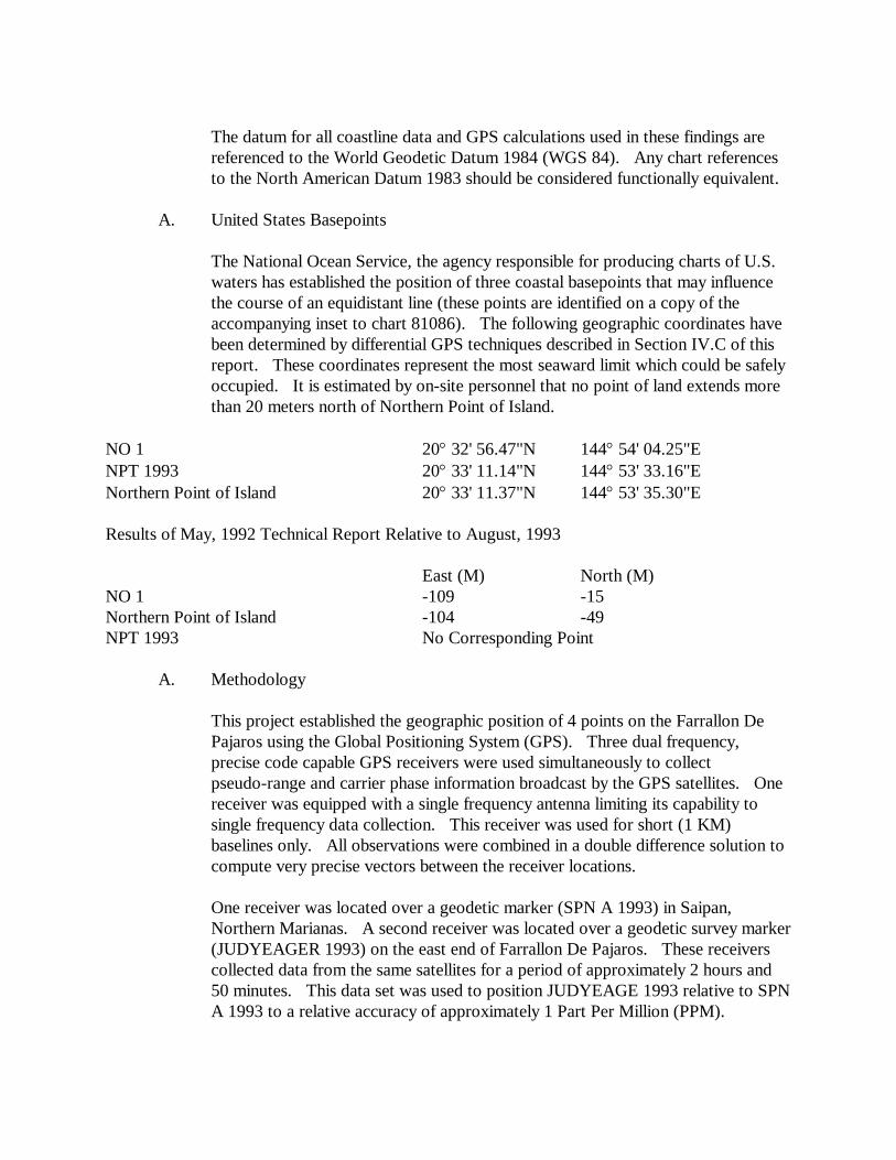
The datum for all coastline data and GPS calculations used in these findings are referenced to the World Geodetic Datum 1984 (WGS 84). Any chart references to the North American Datum 1983 should be considered functionally equivalent.
A. United States Basepoints
The National Ocean Service, the agency responsible for producing charts of U.S. waters has established the position of three coastal basepoints that may influence the course of an equidistant line (these points are identified on a copy of the accompanying inset to chart 81086). The following geographic coordinates have been determined by differential GPS techniques described in Section IV.C of this report. These coordinates represent the most seaward limit which could be safely occupied. It is estimated by on-site personnel that no point of land extends more than 20 meters north of Northern Point of Island.
NO 1 20° 32' 56.47"N 144° 54' 04.25"E NPT 1993 20° 33' 11.14"N 144° 53' 33.16"E Northern Point of Island 20° 33' 11.37"N 144° 53' 35.30"E Results of May, 1992 Technical Report Relative to August, 1993
East (M) North (M) NO 1 -109 -15 Northern Point of Island -104 -49 NPT 1993 No Corresponding Point
A. Methodology
This project established the geographic position of 4 points on the Farrallon De Pajaros using the Global Positioning System (GPS). Three dual frequency, precise code capable GPS receivers were used simultaneously to collect pseudo-range and carrier phase information broadcast by the GPS satellites. One receiver was equipped with a single frequency antenna limiting its capability to single frequency data collection. This receiver was used for short (1 KM) baselines only. All observations were combined in a double difference solution to compute very precise vectors between the receiver locations.
One receiver was located over a geodetic marker (SPN A 1993) in Saipan, Northern Marianas. A second receiver was located over a geodetic survey marker (JUDYEAGER 1993) on the east end of Farrallon De Pajaros. These receivers collected data from the same satellites for a period of approximately 2 hours and 50 minutes. This data set was used to position JUDYEAGE 1993 relative to SPN A 1993 to a relative accuracy of approximately 1 Part Per Million (PPM).
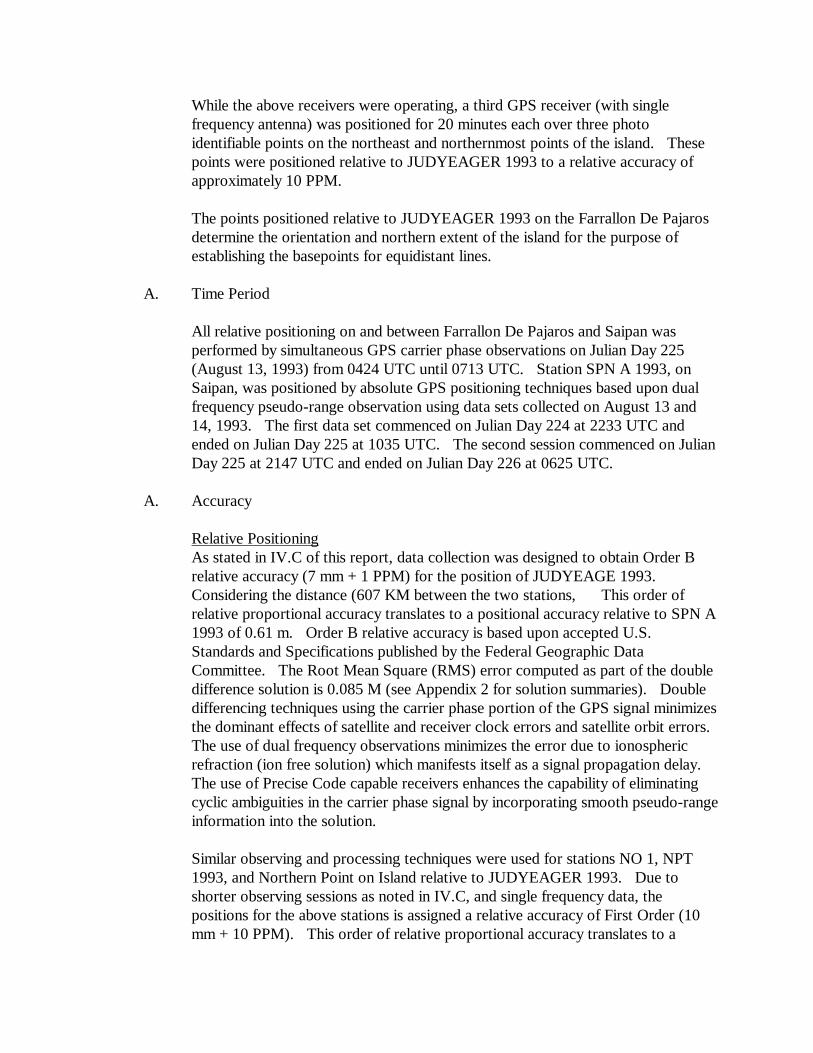
While the above receivers were operating, a third GPS receiver (with single frequency antenna) was positioned for 20 minutes each over three photo identifiable points on the northeast and northernmost points of the island. These points were positioned relative to JUDYEAGER 1993 to a relative accuracy of approximately 10 PPM.
The points positioned relative to JUDYEAGER 1993 on the Farrallon De Pajaros determine the orientation and northern extent of the island for the purpose of establishing the basepoints for equidistant lines.
A. Time Period
All relative positioning on and between Farrallon De Pajaros and Saipan was performed by simultaneous GPS carrier phase observations on Julian Day 225 (August 13, 1993) from 0424 UTC until 0713 UTC. Station SPN A 1993, on Saipan, was positioned by absolute GPS positioning techniques based upon dual frequency pseudo-range observation using data sets collected on August 13 and 14, 1993. The first data set commenced on Julian Day 224 at 2233 UTC and ended on Julian Day 225 at 1035 UTC. The second session commenced on Julian Day 225 at 2147 UTC and ended on Julian Day 226 at 0625 UTC.
A. Accuracy
Relative Positioning As stated in IV.C of this report, data collection was designed to obtain Order B relative accuracy (7 mm + 1 PPM) for the position of JUDYEAGE 1993. Considering the distance (607 KM between the two stations, This order of relative proportional accuracy translates to a positional accuracy relative to SPN A 1993 of 0.61 m. Order B relative accuracy is based upon accepted U.S. Standards and Specifications published by the Federal Geographic Data Committee. The Root Mean Square (RMS) error computed as part of the double difference solution is 0.085 M (see Appendix 2 for solution summaries). Double differencing techniques using the carrier phase portion of the GPS signal minimizes the dominant effects of satellite and receiver clock errors and satellite orbit errors. The use of dual frequency observations minimizes the error due to ionospheric refraction (ion free solution) which manifests itself as a signal propagation delay. The use of Precise Code capable receivers enhances the capability of eliminating cyclic ambiguities in the carrier phase signal by incorporating smooth pseudo-range information into the solution.
Similar observing and processing techniques were used for stations NO 1, NPT 1993, and Northern Point on Island relative to JUDYEAGER 1993. Due to shorter observing sessions as noted in IV.C, and single frequency data, the positions for the above stations is assigned a relative accuracy of First Order (10 mm + 10 PPM). This order of relative proportional accuracy translates to a

positional accuracy relative to JUDYEAGER 1993 of 0.023 m. First Order relative accuracy is based upon accepted U.S. Standards and Specifications published by the Federal Geographic Data Committee. The Root Mean Square (RMS) error computed as part of the double difference solution is 0.012 m (see Appendix 2 for solution summaries).
Absolute Positioning The position for SPN A 1993 was computed form pseudo-range observations obtain from two separate sessions. The broadcast ephemeris was used for determining the positions of the satellites. The computed position differed by 5.9 m between the first and second session. The mean position of these two data sets represents the adopted WGS 84 position for SPN A 1993. The absolute accuracy for SPN A 1993 is estimated to be 3 m based on the statistics of the solution and predicted orbital accuracies obtainable from the broadcast ephemeris.
V. FIELD WORK
A. Chronology
Refer to IV.D. of this report for the project chronology.
B. Survey Personnel
Captain Lewis A. Lapine, NOAA Chief, National Geodetic Survey
Lieutenant William B. Kearse, NOAA Aircraft Operations Center
William McLemore Chief, Photogrammetry Branch Planning Section
C. Instrumentation
The instrumentation used for this project was 3 Trimble Navigation model 4000SSE carrier phase and precise coded pseudo range dual frequency GPS receivers (serial numbers 2686, 2733, and 2736). Two of the three antennas were Trimble Model 4000SSE dual frequency ground plane antennas. The third antenna was a Trimble Kinematic single frequency antenna.
D. Survey Monumentation
Station SPN A 1993 was monumented using a standard National Ocean Service brass disk stamped as above and cemented in a drill hole in a cement foundation at the Saipain International airport. Stations JUDYEAGER 1993 and NPT 1993
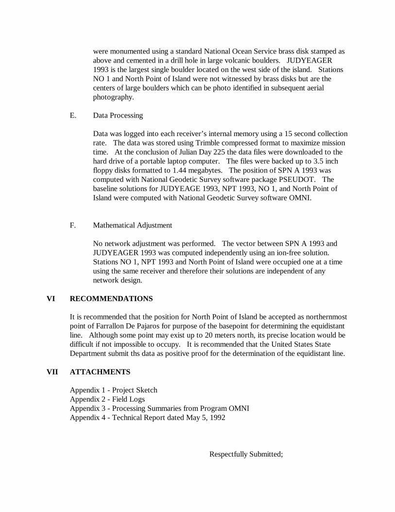
were monumented using a standard National Ocean Service brass disk stamped as above and cemented in a drill hole in large volcanic boulders. JUDYEAGER 1993 is the largest single boulder located on the west side of the island. Stations NO 1 and North Point of Island were not witnessed by brass disks but are the centers of large boulders which can be photo identified in subsequent aerial photography.
E. Data Processing
Data was logged into each receiver’s internal memory using a 15 second collection rate. The data was stored using Trimble compressed format to maximize mission time. At the conclusion of Julian Day 225 the data files were downloaded to the hard drive of a portable laptop computer. The files were backed up to 3.5 inch floppy disks formatted to 1.44 megabytes. The position of SPN A 1993 was computed with National Geodetic Survey software package PSEUDOT. The baseline solutions for JUDYEAGE 1993, NPT 1993, NO 1, and North Point of Island were computed with National Geodetic Survey software OMNI.
F. Mathematical Adjustment
No network adjustment was performed. The vector between SPN A 1993 and JUDYEAGER 1993 was computed independently using an ion-free solution. Stations NO 1, NPT 1993 and North Point of Island were occupied one at a time using the same receiver and therefore their solutions are independent of any network design.
VI RECOMMENDATIONS
It is recommended that the position for North Point of Island be accepted as northernmost point of Farrallon De Pajaros for purpose of the basepoint for determining the equidistant line. Although some point may exist up to 20 meters north, its precise location would be difficult if not impossible to occupy. It is recommended that the United States State Department submit ths data as positive proof for the determination of the equidistant line.
VII ATTACHMENTS
Appendix 1 - Project Sketch Appendix 2 - Field Logs Appendix 3 - Processing Summaries from Program OMNI Appendix 4 - Technical Report dated May 5, 1992
Respectfully Submitted;

Lewis A. Lapine Captain, NOAA Chief, National Geodetic Survey


LeW, I computed 9 positions for various islands in the Pacific using the data we collected in the fall. I compared the position for SPNAAA that you used for the computations for Farrallon De Pajaros and what I computed holding to Kokee Park ITRF92 published position.
Yours from your report: 15 06 56.55501
145 42 59.65103 125.4259
Mine 15 06 56.7228 145 42 59.8783 118.166 Pam FROM STATION LATITUDE: 15 6 56.55501 FROM STATION LONGITUDE: 15 6 56.55501 TO STATION LONGITUDE: 145 42 59.65193 FORWARD AZIMUTH FROM SOUTH =127 14 1.60 BACK AZIMUTH FROM SOUTH = 307 14 1.54 DISTANCE IN METERS = 8.5233
GPS22 VERSION: 06JAN93 (gps22-v3.23)
DATE AND TIME THIS SOLUTION: 1993/ 8/17 13:49:43
ANALYST’S NAME: L. Lapine --------------------------------------------------------------------------------------------------- CURRENT GPS22 SETUP DB NAME: B225 PROCESSING MODE: SOLUTION CORRELATIONS: YES
DOY:HR:MN SEC DOY:HR:MN: SEC START 1 0 0 0.00 STOP: 365 23 59 60.00 FREQUENCY: L1 TROPO CORR: YES ION MODEL: NO OMITTED Svs: 15 27 ADJUSTED SV ARC ELEMENTS: 0 0 0 0 0 0

REF SV: 7 STATION SUMMARY
NAME STAT CLK SHT NAME STAT CLK SHT Saipan_A_199 OMIT NO FIX NPT_1993 SLV NO SLV JUDYEAGER_19 RIF NO SLV NorthernPoint SLV NO SLV NO1ANCI SLV NO SLV DATABASE HISTORY: M: : PROGRAM MERGE WAS RUN BY: L. Lapine DATE: 1993/8/16 M: : ORBIT TYPE: BROADCAST FILE: SPNA224A.ORB DATABASE: a225 • TSTRT: 93 225 4 24 15.00
TSTOP: 93 225 7 13 45.02 SETUP SUMMARY
# CLOCK TERMS: 0 # INTEGER TERMS: 45 # SCL HGT TERMS: 4 # SAT ARC TERMS: 0 # COORDINATES: 9
# TOTAL TERMS: 58 REFERENCE SATELLITE SCENARIO JREF DOY HR MN SEC 7 225 4 24 45.0 RMS VALUES (m): OVERALL RMS OF FIT= 0.0116 STATION 2 3 7 9 13 14 STA 1 0.000 0.000 0.000 0.000 0.000 0.000 STA 2 0.000 0.000 0.000 0.000 0.000 0.000 STA 3 0.003 0.000 0.000 0.000 0.003 0.002 STA 4 0.018 0.000 0.000 0.000 0.022 0.024 STA 5 0.000 0.000 0.000 0.000 0.003 0.000 STATION 15 16 18 19 22 24 STA 1 0.100 0.000 0.000 0.000 0.000 0.000 STA 2 0.100 0.000 0.000 0.000 0.000 0.000 STA 3 0.100 0.000 0.003 0.000 0.000 0.000 STA 4 0.100 0.000 0.029 0.000 0.000 0.000 STA 5 0.100 0.007 0.006 0.006 0.000 0.006

STATION 26 27 28 29 31 STA 1 0.000 0.100 0.000 0.000 0.000 STA 2 0.000 0.100 0.000 0.000 0.000 STA 3 0.000 0.100 0.000 0.003 0.000 STA 4 0.000 0.100 0.000 0.003 0.000 STA 5 0.000 0.100 0.000 0.007 0.000 = = = = = = = = = = = = = = = = = = = = = = = = = = = = = = = = = = = = = = = = = = = = = = = = = = = = = = = = = = = = = STATION: JUDYEAGER_19 DATE: 8/13/93 DB NAME:
B225
INPUT CORR (m) ADJ SIMGA (m)
ANTENNA
X -4888552.4280 0.0000 -4888552.4280 0.0000 Y 3435417.5899 0.0000 3435417.5899 0.0000 Z 2224451.4573 0.0000 2224451.4573 0.0000
OFFSET
NORTH 0.0000 EAST 0.0000 UP 1.3000
L1-L2 0.0020 MONUMENT
X -4888551.4320 0.0000 -4888551.4320 0.0000 Y 3435416.8900 0.0000 3435416.8900 0.0000 Z 2224451.0010 0.0000 2224451.0010 0.0000
LAT 20 32 46.54239 0.0000 20 32 46.54239 0.0000
LON 144 54 8.88553 0.0000 144 54 8.88553 0.0000
ELV 72.3447 0.0000 7.3447 0.0000
TROPOSHPERIC SCALE HEIGHT CORRECTION = 1.39 (+- 0.87) BASELINES WRT: JUDYEAGER_19 NAME X Y Z L NO1NANCI 159.0711 52.3068 288.6725 333.7236 NPT_1993 818.1351 690.0160 705.8925 1282.0887 Northern Point 784.0765 638.2598 712.7409 1236.9927 = = = = = = = = = = = = = = = = = = = = = = = = = = = = = = = = = = = = = = = = = = = = = = = = = = = = = = = = = = =
= = STATION: NO1NANCI DATE: 8/13/93 DB NAME: B225
INPUT CORR (m) ADJ SIGMA (m) ANTENNA
X -4888397.0031 3.0901 -4888393.9130 0.0149 Y 3435469.4558 0.8318 3435470.2876 0.0095 Z 2224738.8001 1.5845 2224740.3846 0.0059
OFFSET
NORTH 0.0000 EAST 0.0000 UP 2.0260
L1-L2 0.0040 MONUMENT
X -4888395.4510 3.0901 -4888392.3609 0.0149 Y 3435468.3650 0.8318 3435469.1968 0.0095 Z 2224738.0890 1.5845 2224739.6735 0.0059
LAT 20 32 56.40234 2.2032 20 32 56.47398
0.0018 LON 144 54 4. 33551 -2.4573 144 54 4.25068
0.0020 ELV 81.3220 -1.3634 79.9596
0.0184
L1 FIXED INTEGERS - JREF SV# = 7
SV# INTEGER 2 2.0
13 -3541996.0 14 240.0 18 -52.0 29 237.0 TROPOSHERIC SCALE HEIGHT CORRECTION = 1.40 (+- 0.87) BASELINES WRT: NO1NANCI NAME X Y Z L JUDYEAGER_19 -159.0711 -52.3068 -288.6725 333 .7236 NPT_1933 659.0640 637.7092 471.2200 1007. 5271 NorthernPoin 652.0054 585.9530 424.0684 955.9323 = = = = = = = = = = = = = = = = = = = = = = = = = = = = = = = = = = = = = = = = = = = = = = = = = = = = = = = = = = = = = STATION: NPT_1993 DATE: 8/13/93 DB NAME: B225
INPUT CORR (m) ADJ SIGMA (m)
ANTENNA X -4887736.2379 1. 3891 -4887734.8488 0.0094 Y 3436101.8570 6. 1400 3436107.9970 0.0066 Z 2225154.8523 2 .7525 2225157.6047 0.0057
OFFSET
NORTH 0.0000 EAST 0.0000 UP 2.0260
L1- L2 0.0040 MONUMENT
X -4887734.6860 1.3891 -4887733.2969 0.0094 Y 3436100.7660 6.1400 3436106.9060 0.0066 Z 2225154.1410 2.7525 2225156.8935 0.0057
LAT 20 33 11.08951 1.7365 20 33 11.14598
0.0023 LON 144 53 33.35653 -5.8219 144 53 33.15554
0.0026 ELV 61.7116 3.2087 64. 9203
0.0124 L1 FIXED INTEGERS - JREF SV# = 7
SV# INTEGER 2 14997.0
13 -3541837.0 14 15379.0
18 -44.0 29 202.0 TROPOSHERIC SCALE HEIGHT CORRECTION = 1.38 (+-.087) BASELINES WRT: NPT_1993 NAME X Y Z L JUDYEAGER_19 -818.1351 -690.0160 -705.8925 1282.0887 NO1NANCI -659.0640 -637.7092 -417.2200 1007.5271 NorthernPoin -34.0586 -51.7562 6.8484 62.3346 = = = = = = = = = = = = = = = = = = = = = = = = = = = = = = = = = = = = = = = = = = = = = = = = = = = = = = = = = = = = =
STATION: NorthernPoin DATE: 8/13/93 DB NAME: B225
INPUT CORR (m) SIGMA (m) ANTENNA
X -4887769.6260 2.2705 -4887768.9074 0.0182 Y 3436043.3720 12.8688 3436056.2408 0.0121 Z 2225158.4239 6.0239 2225164.4531 0.0088
OFFSET
NORTH 0.0000
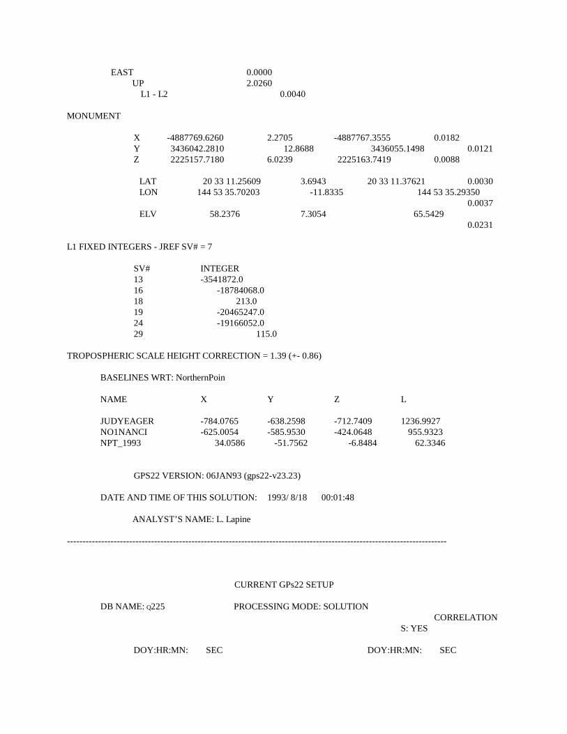
EAST 0.0000 UP 2.0260
L1 - L2 0.0040 MONUMENT
X -4887769.6260 2.2705 -4887767.3555 0.0182 Y 3436042.2810 12.8688 3436055.1498 0.0121 Z 2225157.7180 6.0239 2225163.7419 0.0088
LAT 20 33 11.25609 3.6943 20 33 11.37621 0.0030 LON 144 53 35.70203 -11.8335 144 53 35.29350
0.0037 ELV 58.2376 7.3054 65.5429
0.0231 L1 FIXED INTEGERS - JREF SV# = 7
SV# INTEGER 13 -3541872.0 16 -18784068.0 18 213.0 19 -20465247.0 24 -19166052.0 29 115.0
TROPOSPHERIC SCALE HEIGHT CORRECTION = 1.39 (+- 0.86)
BASELINES WRT: NorthernPoin
NAME X Y Z L
JUDYEAGER -784.0765 -638.2598 -712.7409 1236.9927 NO1NANCI -625.0054 -585.9530 -424.0648 955.9323 NPT_1993 34.0586 -51.7562 -6.8484 62.3346
GPS22 VERSION: 06JAN93 (gps22-v23.23)
DATE AND TIME OF THIS SOLUTION: 1993/ 8/18 00:01:48
ANALYST’S NAME: L. Lapine -------------------------------------------------------------------------------------------------------------------------- CURRENT GPs22 SETUP
DB NAME: Q225 PROCESSING MODE: SOLUTION CORRELATIONS: YES
DOY:HR:MN: SEC DOY:HR:MN: SEC

START: 1 0 0 0.0 STOP 365 23 59 60:00
FREQUENCY: L3 TROPO CORR:YES ION MODEL: NO OMITTED Svs: ADJUSTED SV ARC ELEMENTS: 0 0 0 0 0 0 REF SV: 31
STATION SUMMARY
NAME STAT CLK SHT NAME STAT CLK SHT PAGAN_1_USGS SLV NO SLV Saipan_A_199 REF NO
FIX MACAW1993 OMIT NO SLV SARIGANDATUM OMIT NO SLV AGRIHANDATUM OMIT NO SLV DATABASE HISTORY: M: : PROGRAM MERGE WAS RUN BY: L. Lapine DATE: 1993/ 8/17 M: : ORBIT TYPE: BROADCAST FILE: SPNA225A.ORB DATABASE: p225 * TSTRT: 93 225 21 38 45.00 TSTOP: 93 226 4 56 45.00 SETUP SUMMARY
#CLOCK TERMS: 0 #INTEGER TERMS: 16 #SCL HGT TERMS: 1
#SAT ARC TERMS: 0 #COORDINATES: 3
#TOTAL TERMS: 20 REFERENCE SATELLITE SCENARIO JREF DOY HR MN SEC 31 225 21 39 15.0 14 226 4 31 15.0 RMS VALUES(m):
OVERALL RMS OF FIT= 0.0541 STATION 2 7 13 14 15 16 STA 1 0.000 0.000 0.000 0.038 0.051 0.000 STA 2 0.000 0.000 0.000 0.000 0.000 0.000 STA 3 0.000 0.000 0.000 0.000 0.000 0.000 STA 4 0.000 0.000 0.000 0.000 0.000 0.000

STA 5 0.000 0.000 0.000 0.000 0.000 0.000 STATION 17 18 19 21 22 25 STA 1 0.039 0.000 0.031 0.039 0.048 0.079 STA 2 0.000 0.000 0.000 0.000 0.000 0.000 STA 3 0.000 0.000 0.000 0.000 0.000 0.000 STA 4 0.000 0.000 0.000 0.000 0.000 0.000 STA 5 0.000 0.000 0.000 0.000 0.000 0.000 STATION 27 28 29 31 STA 1 0.090 0.061 0.044 0.000 STA 2 0.000 0.000 0.000 0.000 STA 3 0.000 0.000 0.000 0.000 STA 4 0.000 0.000 0.000 0.000 STA 5 0.000 0.000 0.000 0.000 = = = = = = = = = = = = = = = = = = = = = = = = = = = = = = = = = = = = = = = = = = = = = = = = = = = = = = = = = = = = = STATION: PAGAN1USGS DATE: 8/13/93 DB NAME: Q225
INPUT CORR (m) ADJ SIGMA (m) ANTENNA
X -5012586.5139 -1.1104 -5012587.6243 0.0233 Y 3412021.2241 -0.5040 3412020.7200 0.0130 Z 1971658.9056 1.0994 1971660.0050 0.0073
OFFSET
NORTH 0.0000 EAST 0.0000 UP 1.0080
L1 -L2 0.0020 MONUMENT
X -5012585.7220 -1.1104 -5012586.8324 0.0233 Y 3412021.2241 -0.5040 3412020.7200 0.0130 Z 1971658.9056 1.0994 1971660.0050 0.0073
OFFSET
NORTH 0.0000 EAST 0.0000 UP 1.0080 L1-L2 0.0020
MONUMENT
X -5012585.7220 -1.1104 -5012586.8324 0.0233 Y 3412020.6850 -0.5040 3412020.1810 0.0130 Z 1971658.5920 1.0994 1971659.6914 0.0073
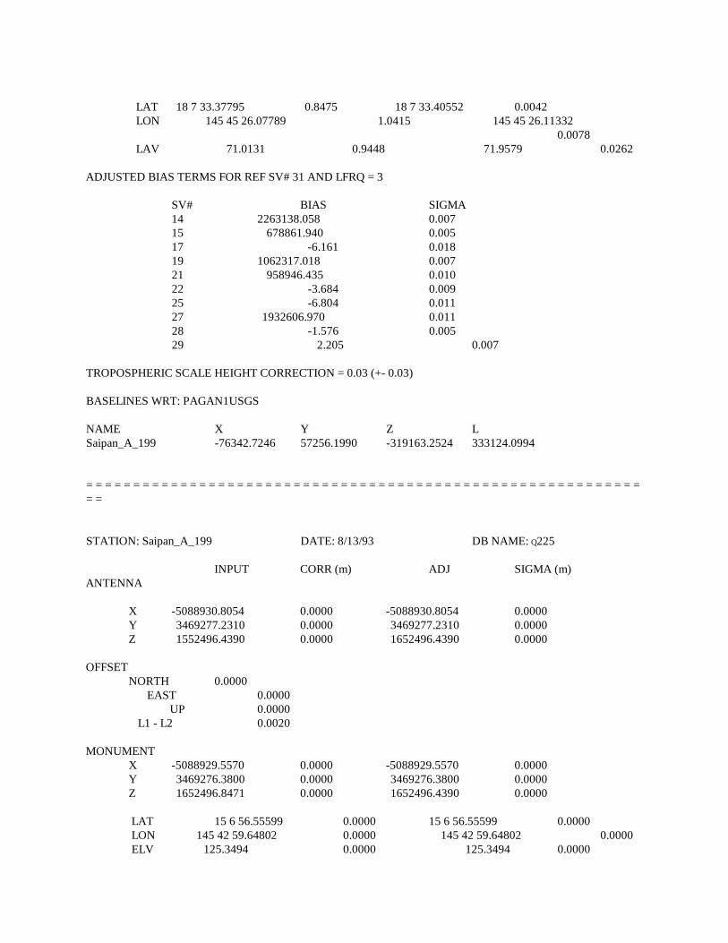
LAT 18 7 33.37795 0.8475 18 7 33.40552 0.0042 LON 145 45 26.07789 1.0415 145 45 26.11332
0.0078 LAV 71.0131 0.9448 71.9579 0.0262 ADJUSTED BIAS TERMS FOR REF SV# 31 AND LFRQ = 3
SV# BIAS SIGMA 14 2263138.058 0.007 15 678861.940 0.005 17 -6.161 0.018 19 1062317.018 0.007 21 958946.435 0.010 22 -3.684 0.009 25 -6.804 0.011 27 1932606.970 0.011 28 -1.576 0.005 29 2.205 0.007
TROPOSPHERIC SCALE HEIGHT CORRECTION = 0.03 (+- 0.03) BASELINES WRT: PAGAN1USGS NAME X Y Z L Saipan_A_199 -76342.7246 57256.1990 -319163.2524 333124.0994
= = = = = = = = = = = = = = = = = = = = = = = = = = = = = = = = = = = = = = = = = = = = = = = = = = = = = = = = = = = = = STATION: Saipan_A_199 DATE: 8/13/93 DB NAME: Q225
INPUT CORR (m) ADJ SIGMA (m) ANTENNA
X -5088930.8054 0.0000 -5088930.8054 0.0000 Y 3469277.2310 0.0000 3469277.2310 0.0000 Z 1552496.4390 0.0000 1652496.4390 0.0000
OFFSET
NORTH 0.0000 EAST 0.0000 UP 0.0000 L1 - L2 0.0020
MONUMENT
X -5088929.5570 0.0000 -5088929.5570 0.0000 Y 3469276.3800 0.0000 3469276.3800 0.0000 Z 1652496.8471 0.0000 1652496.4390 0.0000
LAT 15 6 56.55599 0.0000 15 6 56.55599 0.0000 LON 145 42 59.64802 0.0000 145 42 59.64802 0.0000 ELV 125.3494 0.0000 125.3494 0.0000

BASELINES WRT: Saipan_A_199 NAME X Y Z L PAGAN1USGS 76342.7246 -57256.1990 319163.2524 333124.0994
GPS22 VERSION: 06JAN93 (gp22-v3.23)
DATE AND TIME OF THIS SOLUTION: 1993/ 8/17 13:25:34
ANALYST’S NAME: L. Lapine -------------------------------------------------------------------------------------------------------------------------------------- CURRENT GPs22 SETUP DB NAME:B225 PROCESSING MODE:SOLUTION CORRELATIONS:YES
DOY:HR:MN SEC DOY:HR:MN SEC SART 1 0 0 0.0 STOP: 365 23 59 60.00 FREQUENCY: L3 TROPO CORR:YES ION MODEL: NO OMITTED Svs: 15 27 ADJUSTED SV ARC ELEMENTS: 0 0 0 0 0 0 REF SV: 7 DATABASE HISTORY: M: : PROGRAM MERGE WAS RUN BY: L. Lapine DATE: 1993/ 8/16 M: : ORBIT TYPE: BROADCAST FILE: SPNA224A.ORB DATABASE: a225 * TSTRT: 93 225 4 24 15.00 TSTOP: 93 225 7 13 45.02 SETUP SUMMARY
#CLOCK TERMS: 0 #INTEGER TERMS: 15 #SCL HGT TERMS: 1 #SAT ARC TERMS: 0
#COORDINATES: 3
#TOTAL TERMS: 19 REFERENCE SATELLITE SCENARIO JREF DOY HR MN SEC 7 225 4 24 45.0

RMS VALUES (m):
OVREALL RMS OF FIT = 0.0848 STATION 2 3 7 9 13 14 STA 1 0.000 0.000 0.000 0.000 0.000 0.000 STA 2 0.121 0.000 0.000 0.000 0.000 0.000 STA 3 0.000 0.000 0.000 0.000 0.000 0.000 STA 4 0.000 0.000 0.000 0.000 0.000 0.000 STA 5 0.000 0.000 0.000 0.000 0.000 0.000 STATION 15 16 18 19 22 24 STA 1 0.100 0.000 0.000 0.000 0.000 0.000 STA 2 0.100 0.075 0.072 0.057 0.000 0.000 STA 3 0.100 0.000 0.000 0.000 0.000 0.000 STA 4 0.100 0.000 0.000 0.000 0.000 0.000 STA 5 0.100 0.000 0.000 0.000 0.000 0.000 STATION 26 27 28 29 31 STA 1 0.000 0.100 0.000 0.000 0.000 STA 2 0.000 0.100 0.000 0.000 0.000 STA 3 0.000 0.100 0.000 0.000 0.000 STA 4 0.000 0.100 0.000 0.000 0.000 STA 5 0.000 0.100 0.000 0.000 0.000
= = = = = = = = = = = = = = = = = = = = = = = = = = = = = = = = = = = = = = = = = = = = = = = = = = = = = = = = = = = = = STATOPM: Saipan_A_199 DATE: 8/13/93 DB NAME: B225
INPUT CORR (m) ADJ SIGMA (m) ANTENNA
X -5088930.8054 0.0000 -5088930.8054 0.0000 Y 3469277.2310 0.0000 3469277.2310 0.0000 Z 1652496.8471 0.0000 1652496.8471 0.0000
OFFSET
NORTH 0.0000 EAST 0.0000 UP 1.5650 L1 -L2 0.0020
MONUMENT
X -5088929.5570 0.0000 -5088929.5570 0.0000 Y 3469276.3800 0.0000 3469276.3800 0.0000

Z 1652496.4390 0.0000 1652496.4390 0.0000
LAT 15 6 56.55599 0.0000 15 6 56.55599 0.0000 LON 45 42 59.64802 0.0000 145 42 59.64802 0.0000 ELV 125.3494 0.0000 125.3494 0.0000
BASELINES WRT: Saipan_A_199 NAME X Y Z L JUDYEAGER_19 200378.1254 -33859.4895 571954.5618
606984.2493
= = = = = = = = = = = = = = = = = = = = = = = = = = = = = = = = = = = = = = = = = = = = = = = = = = = = = = = = = = = = = STATION: JUDYEAGER_19 DATE: 8/13/93 DB NAME: B225
INPUT CORR (m) ADJ SIGMA (m) ANTENNA
X -4888554.0680 1.6404 -48885522.4276 0.0403 Y 3435414.7799 2.8105 3435417.5904 0.0620 Z 2224448.7183 2/7388 2224451/4570 0/0202
OFFSET
NORTH 0.0000 EAST 0.0000 UP 1.3000 L1 -L2 0.0020
MONUMENT
X -4888553.0720 1.6404 -488551.4316 0.0403 Y 3435414.0800 2.8105 343516.8905 0.0620 Z 2224448.2620 2.7388 2224451.0008 0.0202
LAT 20 32 46.46212 2.4685 20 32 46.54238 0.0092 LON 144 54 8.99745 -3.2427 144 54 8.88551 0.0530 ELV 71.1270 1.2176 72.3446 0.0547
ADJUSTED BIAS TERMS FOR REF SV# 7 AND LFRQ = 3
SV# BIAS SIGMA 2 -10.618 0.023 13 -325998.176 0.009 14 6.939 0.039 16 1053431.087 0.046 18 -6.669 0.029 19 1701008.856 0.046 24 666348.909 0.027 29 4.647 0.049

TROPOSHERIC SCALE HEIGHT CORRECTION = 0.03 (+- 0.01) BASELINES WRT: JUDYEAGER_19 NAME X Y Z L Saipan_A_199 -200378.1254 33859.4895 -571954.5618 606984.2493 MEMORANDUM FOR THE RECORD FROM: Pamela J. Fromhertz
Photogrammetry Branch SUBJECT: American Samoa Shift The final datum shift has been computed by the National Geodetic Survey (NGS) from American Samoa Datum of 1962 to North American Datum of 1983 (NAD 83). The values in the previou Memorandum for the Record were incorrect. The correct values follow. This correction will not effect the shift for mapping purposes. Also, please note NAD 83 is the correct datum for purposes of this shift, not WGS 84. For mapping and charting purposes, NAD 83 and WGS 84 are identical. American Samoa Datum of 1962 to NAD 83: NGS developed a shift between the American Samoa Datum of 1962 and NAD 83 for Tutuila Island and the Manua Islands (Ofu, Olosega, and Tau) based on points in the NGS database that were computed on the American Samoa Datum of 1962 and were re-observed in 1993 and computed on NAD 83. Seven points were used for Tutuila Island and five points for the Manua Islands. These stations and their positions and the shift are attached. The shifts listed below are average of shifts based on the surveyed coordinates of these sets of points.
Tutuila Island Latitude: -17.83406" σ ςø = 0.00775" Longitude: +4.37866" σ ςλ = 0.00148"
Manua Islands Latitude: -18.32515" σ ςø = 0.02022"
Longitude: +4.43134" σ ςλ = 0.00874" Attachment cc: N/CG1 - L. Lapine
N/CG12 - E. McKay N/CG121 - C. Craig N/CG13 - R. Floyd

N/CG13 - B. Rodkey N/CG133 - G. Tolzman N/CG14 - D. Doyle N/CG22 - D. MacFarland N/CG3 - C. Beaver
American Samoa Geodetic Control Stations Used for Computation of Shift Values Tutuila Island
American Samoa Datum Designation of 1962 NAD 83 Shift BM NO 1 14° 16' 52.89091"S 14° 16' 35.06186"S -17.82905"
170° 40' 46.26882"W 170° 40' 50.64533"W + 4.37651"
BREAKERS POINT 14° 17' 41.06229"S 14° 17' 23.23096"S -17.83133" RESET ET 170° 39' 44.81681"S 170° 39' 49.19461"W
+4.37780" LEPISI 14° 20' 12.78108"S 14° 19' 54.94006"S -17.84102"
170° 49' 00.75839"W 170° 49' 05.13712"W + 4.37873"
SATELLITE 14° 20' 12.21614"S 14° 19' 54.37534"S -17.84080" TRIANG STA 022 170° 42' 46.75786"W 170° 44' 51.13727"W +
4.37941" TAFUNA 1A 14° 19' 55.28840"S 14° 19' 37.44924"S -17.83916" RESET ET 170° 42' 07.81667"W 170° 42' 12.19688"W
+4.38021" TULA 14° 15' 47.246622"S 14° 15' 29.42627"S -17.81995"
170° 33' 38.74951"W 170° 33' 43.12698"W + 4.37747"
OLOTELE 2 ET 14° 19' 21.47745"S 14° 19' 03.64037"S -17.83708"
170° 45' 47.00908"W 170° 45' 51.38960"W

+4.38052"
Mean Shift: -17.83406" +4.37866"
σ ςø = 0.00775" (0.237 m) σ ςλ = 0.00148" (0.044 m)
American Samoa Geodetic Control Stations Used for Computation of Shift Values Manua Islands (Ofu, Tau, and Olosega)
American Samoa Datum Designation of 1962 NAD 83
Shift FITIUTA ET 14° 13' 00.72214"S 14° 12' 42.38125"S -18.34089" 169° 25' 33.72683"W 169° 25' 38.16655"W
4.43972" OLOSEGA ET 14° 11' 13.55796"S 14° 10' 55.25963"S -18.29833"
169° 37' 12.93814"W 169° 30' 47.51223"W 4.42044"
TAU ET 14° 14' 33.66300"S 14° 14' 15.34481"S -18.31819"
169° 30' 43.08500"W 169° 30' 47.51223"W 4.42044"
TIAFOU ET 14° 13' 25.73304"S 14° 13' 07.38376"S -18.34928"
169° 25' 04.52758"W 169° 25' 08.96845"W 4.44087" TIDE GAGE ET 14° 14' 46.59449"S 14° 14' 28.27541"S -18.31908"
169° 30' 30.28375"W 169° 30' 34.71218"W

4.42843"
Mean Shift -18.32515" +4.43134"
σ ςø = 0.02022" (0.621 m) σ ςλ = 0.00874" (0.262 m)