Embed Size (px)
Citation preview

APPENDIX B
TYPOLOGY CASE STUDIES

Typology Case Studies B-1APPENDIX BBottineau Transitway Station Area Pre-Planning Study
TOD Typologies have been used in regions around the country, and typologies have been used to answer a variety of questions relating to planning for transportation and land use around a transit node. In some cases, they have helped define a high level vision for station areas. Others have focused on identifying the critical activities that are necessary to implement a vision for TOD. In other cases, they have focused on the question of how to plan for mixed-income communities. The following examples illustrate how some regions and corridors have used the typology approach to answer questions about their station areas and identify some key takeaways for the Bottineau Typology.
SOUTHWEST LRT, TWIN CITIESIn the Twin Cities, CTOD and Stantec worked together to incorporate a development assessment into a corridor-wide station area typology for the Southwest LRT. With an approved transit alignment and some station area planning already complete, this corridor was ready to gain a deeper understanding of the market and development potential at the corridor scale and how development activity is likely to play out at different stations over different time frames.
In order to reach that understanding, this typology explored different aspects of the planned stations, including their role in the transit network (origin vs destination), the scale of change expected (comparing existing uses to future uses), and how market timing, development opportunity and the scale of investment came together to identify opportunity sites and key activities to support or strengthen market activity.
INTRODUCTION

B-2 Typology Case Studies
APPENDIX B Bottineau Transitway Station Area Pre-Planning Study
STATION Origin/ Destination
Scale of TransformationMarket Strength/
TimingDevelopment Opportunity
Scale of Access Investment
Existing Uses Future Uses
Interchange/ Target Field
Destination Commercial/Entertainment Major Urban Center Short-Term Major Opportunity Minor
Royalston Destination Primarily Industrial Major Urban Center Long Term Major Opportunity Key Access Routes
Van White DestinationPrimarily Industrial/
RecreationMajor Urban Center Long Term Major Opportunity Key Access Routes
Penn OriginPrimarily Residential
(Mostly Single Family)Urban Neighborhood Short-Term Infill Minor
21st Street OriginPrimarily Residential
(Mostly Single Family) + Recreation
Urban Neighborhood Long Term None Minor
West Lake MixMix of Commercial
And ResidentialMajor Urban Center Short-Term Infill Key Access Routes
Beltline MixMix of
Commercial/Industrial And Residential
Urban Center Mid-TermMajor Opportunity/
InfillKey Access Routes
21st Street MixMix of Commercial,
Institutions And Residential
Urban Neighborhood Mid-Term Major Opportunity Key Access Routes
Table B.1 - The Southwest Typology (or station characterizations) identified how the market for development, development opportunity and other factors interacted along Southwest LRT stations.

Typology Case Studies B-3APPENDIX BBottineau Transitway Station Area Pre-Planning Study
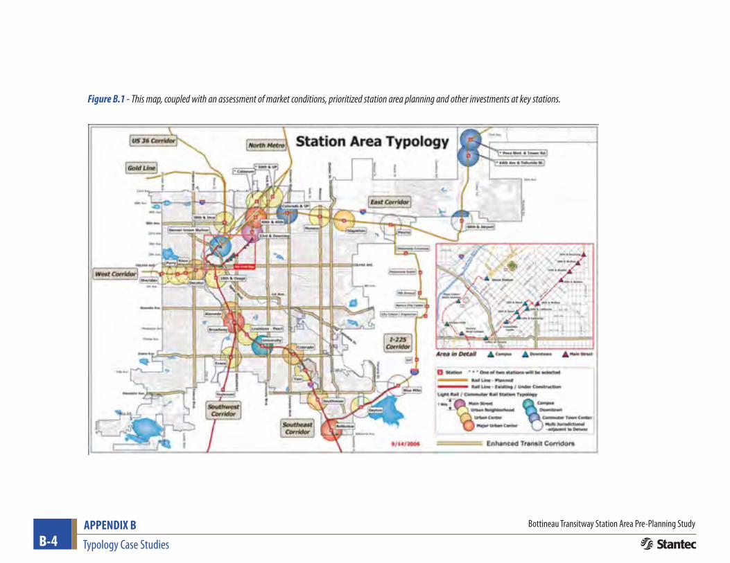
CITY OF DENVER, COLORADODenver developed a TOD typology to provide a vision for the density and land use mix that would be appropriate in each of the City’s existing and planned light rail station areas. The typology was a part of a broader TOD Strategic Plan and served as a guide for subsequent station area planning studies.
The City used a qualitative approach to develop this typology. Figure X shows the information that was used to define each of Denver’s place types, which included not only desired land use mix but more specific direction on desired housing types, employment types, proposed scale, and how stations fit into the transit system.
The aspirational place types defined in the typology were a building block for future planning efforts, giving the City a sense of the different kinds of places that would be connected by transit before station area planning could be completed for all stations. And in some cases, the typology helped the City identify where to prioritize more in-depth station area planning. For example, 10th and Osage was identified as an immediate priority because of the market opportunity and potential for gentrification in the station area.
Denver will be updating the TOD Strategic Plan and station typology in 2012-2013 with an emphasis on developing a typology that is focused around a set of implementation activities.
TOD Typology Desired
Land Use MixDesired
Housing TypesCommercial/
Employment TypesProposed
Scale Transit System Function
Downtown
Office, retail, residential, entertainment, and civic uses
Multi-family and loft
Prime office and shopping location
5 stories and above
Intermodal facility/transit hub. Major regional destination with high quality feeder bus/streetcar connections
Major Urban Center
Office, retail, residential, entertainment
Multi-family and townhome
Employment emphasis, with more than 250,000 sf office & 50,000 sf retail
5 stories and above
Sub-Regional destination. Some Park-n-ride. Linked with district circulator transit and express feeder bus.
Urban Center
Office, retail, residential
Multi-family and townhome
Limited office. Less than 25,000 sf office. More than 50,000 sf retail
3 stories and above
Sub-Regional destination. Some Park-n-ride. Linked with district circular transit and express feeder bus.
Urban Neighborhood
Residential, neighborhood retail
Multi-family townhome, small lot single-family
Local-serving retail. No more than 25,000 sf
2-7 stories
Neighborhood walk-up station. Very small Park-n-ride, if any. Local bus connections.
Community Town Center
Office, retail, residential
Multi-family townhome, small lot single-family
Local and com-muter- serving. No more than 25,000 sf
2-7 stories
Capture station for in-bound commuters. Large Park-n-ride with local and express bus connections.
Main StreetResidential, neighborhood retail
Multi-familyMain street retail infill
2-7 stories
Bus or streetcar corridors. District circulator or feeder transit service. Walk-up stops. No Transit parking.
Campus/Special Events Station
University Campus, Sports Facilities
Limited multi-family
Limited office/retail
Varies
Large commuter destination. Large parking reservoirs but not necessarily for transit.
Table B.2 - Denver’s TOD Typology identified the key land use characteristics of different types of stations throughout the city.
B-4 Typology Case Studies
APPENDIX B Bottineau Transitway Station Area Pre-Planning Study
Figure B.1 - This map, coupled with an assessment of market conditions, prioritized station area planning and other investments at key stations.

Typology Case Studies B-5APPENDIX BBottineau Transitway Station Area Pre-Planning Study
WEST CORRIDOR, DENVER METRO REGIONAlong the West Corridor, multiple jurisdictions came together to develop a TOD typology focused on implementation. Ultimately, the typology helped city staff identify the set of priority actions different station types needed to undertake to move TOD from planning to implementation. The typology also helped the jurisdictions along the line understand how stations had progressed in relation to the City of Denver’s aspirational typology.
The West Corridor will open in 2013 and passes through three cities and two counties. When the West Corridor Planning process was underway, almost every station had already completed a station area plan with a detailed vision for the kinds of housing, land uses, street design, etc that were desired at each station. The station area plans were ambitious in their vision, but did not link to the tools and set of activities that would help make that vision a reality.
Thus, the focus of the corridor planning effort was on identifying priority station areas and what those implementation activities should be. Ultimately, the typology used some baseline analysis to identify three implementation types. The baseline analysis looked at the residential and employment concentrations in station areas to identify the scale of potential change and available land, market interest and existing services to show development potential.
!
!
!
!
!
!
!
!!!
!
!
!
Sta
te H
igh
way
47
0
State Highway 58
I-70
I-70
US Highway 40
US Highway 6
Sta
te H
igh
way
39
1
Sta
te H
igh
way
12
1
I-25
Sta
te H
igh
way
88
Denver County
Jefferson County
OakkOOOOaka
tWestee t WeWWWWWWWWeWeWAurariaAAAuurr riaaraaaar Wea
deral/derr //all/raalFeFeecaturec rrurDeDDeeeDeecatur
ortho tthrto ththWadswWad wWWWWadswwW wWa wWWWW w KnoxKKKKnoxPerryPee ryPerryeridanShehSS eSS erShe dddderrrriddandaaannnee
Lamarmmmmammmam rmGarrisonG risoi nononnr or
Federal CenterFF nedera ed ll nerde Ca ea
Rocks CCRed Rockseed R cRRee c Ce k Cee R
Jefferson Co.efffffffefeffe feffeff rsGovernment CenterCv roovernme tereCG
and 10thd 1Osage aOOOOsaage ae aaan h
[NJanuary 2011
Legend
!
Half-Mile Buffer
County border
State Highways Freeways
Transit Rail Line
Station Station
Transformational
Intensification
Neighborhood Infill
Implementation Types
Source: LEHD 2008,Claritas 2010, CTOD 2010
Figure B.2 - The three different implementation types along the West Corridor were attached to a differ-ent set of implementation activities and next steps.
These three implementation types: transformational, intensification, and neighborhood infill were linked to strategies and next steps that made sense for each implementation type. For instance, transformational stations, with the greatest development potential on the corridor and some of the greatest market strength, are to create TOD master plans and finance or create detailed plans for pedestrian and bicycle connections. The activities prioritized at other stations were smaller in scale.

B-6 Typology Case Studies
APPENDIX B Bottineau Transitway Station Area Pre-Planning Study
BAY AREA, METROPOLITAN TRANSPORTATION COMMISSION (MTC)In the Bay Area, MTC, the regional transportation planning organization, created a regional TOD typology to assist with the planning local cities and counties were doing around their new and existing transit stations. This planning was mostly in response to MTC’s 2005 TOD Policy, which required jurisdictions to plan for specified amounts of housing in exchange for MTC funding the new transit lines. MTC offered grants to support that local planning work but found that local jurisdictions wanted more direction in understanding the scale and types of development they should anticipate near their stations.
The place types were developed to give local jurisdictions and planning staff a range of options for what TOD in their communities could look like. They were defined by both existing and future characteristics, including land use mix, the type of transit service, and the scale of new development.
City-staff self-selected their place types, which gave them a starting place for approaching station area planning. The place types were also linked to a set of development guidelines that local staff could use to plan for the types of housing, the number of jobs, minimum FAR and density requirements.
Ultimately, MTC’s goal was to ensure that the regional transit investments they were making would be as efficient as possible and would attract the riders that the system needed to sustain itself. The typology, which helped local jurisdictions to focus growth around transit nodes, was one key approach to that goal.
City Center Suburban Center Transit Town Center
Centers
Regional Center
Key
Iden
tifyi
ng Q
uest
ions
What are/will be the characteristics of the
Station Area?
What is/will be the transit mode in the
Station Area?
What is/will be the land use mix and density in
the Station Area?
What are/will be the characteristics of retail
in the Station Area?
What are/will be major planning and developmentchallenges?
Example [2]
[1] Station Area typically refers to half mile radius around station or roughly 500 acres[2] Station Areas are typically a mix of characteristics of several Place Types. These examples are meant to be illustrative of the qualities only.N
otes
Primary center of economic and cultural activity.
All Modes
High-density mix of residential, commercial,
employment,and civic/cultural uses.
Regional-serving destination retail opportunity; need for
local-serving retail
Integrating dense mix of housing and employment into
built-out context.
Downtown San Francisco, Oakland & San Jose
Significant center of economic and cultural activity with
regional-scale destinations.
All Modes
Moderate- to high-density mix of residential, commercial,
employment, and civic/cultural uses.
Regional-serving destination retail opportunity; need for
local-serving and community-serving retail
Integrating high-density housing into existing mix of housing and employment to support local-serving retail.
Downtown Hayward, Berkeley, Redwood City & Santa Rosa
Significant center of economic and cultural activity with
regional-scale destinations.
All Modes
Moderate- to high-density mix of residential, commercial,
employment, and civic/cultural uses.
Regional-serving destination retail opportunity; need for
local-serving and community-serving retail
Introducing housing into predominantly employment
uses and improving connections/access to transit.
Pleasant Hill BART, Dublin/Pleasanton BART
Local center of economic and community activity.
Commuter Rail, Local/Regional Bus Hub, Ferry,
Potentially BART
Moderate-density mix of residential, commercial,
employment, and civic/cultural uses.
Community-serving and destination retail opportunity; need for local-serving retail.
Increasing densities while retaining scale and improving
transit access.
Hercules Waterfront,Suisun City, Napa, Livermore
STATION AREA PLANNING MANUALPLACE TYPE IDENTIFICATION
T
14
Table B.3- The places types developed for the Bay Area region ranged from Regional Centers to Transit Neighborhoods and were defined by the land uses, densities, and other characteristics of station areas.

Typology Case Studies B-7APPENDIX BBottineau Transitway Station Area Pre-Planning Study
SOMERVILLE, MA (BOSTON REGION)In Somerville, an inner-city suburb outside of Boston, a new rail investment (the Green Line) was planned that would drastically increase the number of transit stations in the city and make it easier to reach other regional destinations in Boston. In response to this transit planning, a social equity-focused community group developed a typology to identify where displacement and gentrification might occur.
This group (the Somerville Community Corporation) wanted to ensure that when the transit line came to their town, that people of all incomes could access the transit and benefit from the connections to employment, services, and housing that it could provide.
Somerville’s typology identified five different neighborhood types, as seen in Figure 6, based on market strength, land opportunity, access needs, and the potential for displacement. Each place type was linked to a set of affordable housing strategies that made the most sense in that neighborhood (preservation of affordable housing vs production.) Somerville Equitable TOD Strategy | Equitable TOD Opportunities and Strategies May 2008
29
Map �0: Somerville Equitable Development Opportunity AreasFigure B.3- Somerville’s typology was focused on the different effects transit might have on neighbor-hoods in the city and how affordable housing strategies could prevent displacement.

B-8 Typology Case Studies
APPENDIX B Bottineau Transitway Station Area Pre-Planning Study
CENTRAL MARYLAND (BALTIMORE)In the Central Maryland/Baltimore region, another equity group had a similar idea. The TOD typology aimed to answer a couple of key questions: where market rate development was most likely to occur and how neighborhoods might change in the future and be vulnerable to displacement.
The answers to these questions then identified station area investment needs and assigned next steps to a broad range of TOD actors and stakeholders, including affordable housing developers, the State of Maryland, the City of Baltimore and its surrounding counties, and non-profit and philanthropic groups. This typology was folded into a broader TOD Strategic Plan that has enabled Baltimore to more systematically fund transit-supportive projects, rather than continuing in a less effective, piecemeal fashion as was historic practice. The typology also identified a set of high priority locations and low priority locations for TOD throughout the region.
Central Maryland Transit-Oriented Development Strategy / Executive Summary: Regional Investments for Transit-Centered Communities ES-11
July 2009
There is commonality among the TOD Approaches, but there are also some key differences. Some will be more targeted to investment in new TOD construction, while others will be targeted to investment in preservation and community development outcomes. Some will rate equitable TOD as a top priority and reason for engagement, while others will be able to leverage equitable outcomes from TOD, while accomplishing other priorities.
Using this framework, we can identify an appropriate TOD Approach for existing and planned stations as a starting point for approaching TOD planning in individual locations. These broad approaches need to be implemented through policy and investment tools.
In an era of limited resources, making investment decisions necessitates a comprehensive approach. Given the multiple stakeholders engaged in transit-oriented development, communication and coordination across stakeholders is especially important.
The relative resource intensity and priority in a particular location will vary for each stakeholder engaged in TOD planning and implementation based on the TOD Approach.
NEIGHBORHOOD SCREEN
STABLE COMMUNITY
VULNERABLE COMMUNITY
CHALLENGED COMMUNITY
EMPLOYMENT CENTER
CMS I-70 EAST
EDMONDSON VILLAGE
FELLS POINT
OWINGS MILLS HOPKINS HOSPITAL
WOODBERRY
BAYVIEW CAMPUS
COLDSPRING LANE
ROGERS AVEMARTIN STATE AIRPORT
WHITE MARSH WESTPORT
W BALTIMORE MARC
CHERRY HILL
PENN STATION
ABERDEEN
REISTERSTOWN PLAZA
STATE CENTER
TOWSON
ODENTON
INNER HARBOR EAST
BWI STATION
HUNT VALLEYTOD
OPPO
RTUN
ITY
TYPE
SHORT-TERM DEVELOPMENT
LONG-TERM DEVELOPMENT
EMERGING MARKET
STATICMARKET
DEVELOPMENT FACILITATION
MARKETPRIMING
PROACTIVE EQUITABLE DEVELOPMENT
NEIGHBORHOOD REINFORCEMENT
PROACTIVEMIXED-INCOME
MARKETCATALYST
MONITOR & RESPOND
QUALITY-OF-LIFE IMPROVEMENTS
TOD Approach Types with example stations.
Figure B.4- The Baltimore Typology and TOD Strategic Plan evaluated development and demographic characteristics to define future investment priorities.
Typology Case Studies B-9APPENDIX BBottineau Transitway Station Area Pre-Planning Study
KEY LESSONS LEARNED FOR BOTTINEAUThese typologies offer a range of examples for the Bottineau Corridor. Knowing what question the typology is being used to answer will guide how the typology is defined and what characteristics and analysis are important inputs. One of the larger questions along Bottineau relates to wanting to better understand and articulate what kinds of TOD might occur or make sense around planned stations. This was the case in Denver and the Bay Area, where aspirational typologies focused on future land uses and scales of development were used.
The timing and status of the transit investment also feeds into what the typology will look like. Again, when the planning around the transit investment is still in preliminary stages, identifying the range of place types around future stations is an important step for land use planning. Looking at existing conditions while envisioning future uses is another common element to many of these typologies. Comparing what is near a planned station today to what is desired for that station area in the future illustrates the scale of the change necessary, which can be transformational and require a deeper level of planning and public leadership, or it could be smaller scale, in which case basic zoning changes and pedestrian improvements may be sufficient.
Keeping it simple is another key lesson, especially at the onset of a project. The more approachable a typology is for staff, elected officials, advocates, and the public, the more likely it will be useful in future planning work. A typology is a tool that is not static. It can be updated and tailored as transit planning moves through the lengthy process to implementation.
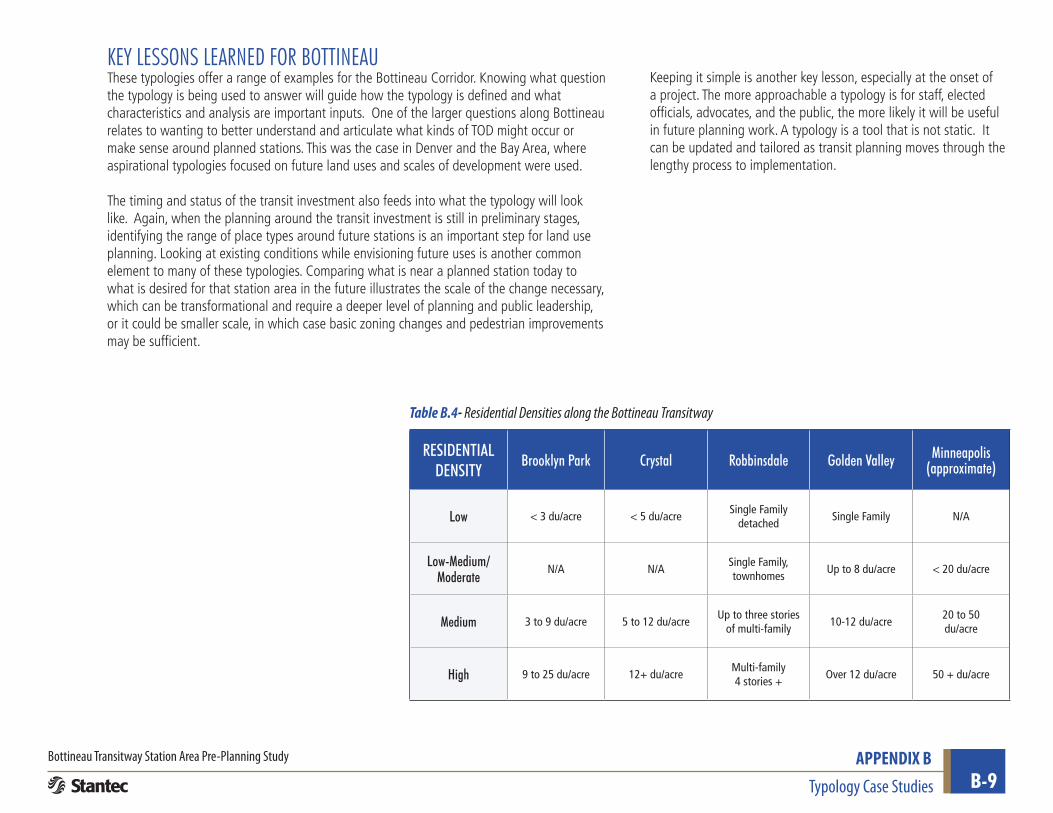
RESIDENTIAL DENSITY
Brooklyn Park Crystal Robbinsdale Golden Valley Minneapolis (approximate)
Low < 3 du/acre < 5 du/acreSingle Family
detachedSingle Family N/A
Low-Medium/Moderate
N/A N/A Single Family, townhomes
Up to 8 du/acre < 20 du/acre
Medium 3 to 9 du/acre 5 to 12 du/acreUp to three stories
of multi-family10-12 du/acre
20 to 50 du/acre
High 9 to 25 du/acre 12+ du/acreMulti-family 4 stories +
Over 12 du/acre 50 + du/acre
Table B.4- Residential Densities along the Bottineau Transitway