Embed Size (px)
Citation preview
URBAN FORMtwo

2-2
URBAN FORM GOALS
GOAL UF–1 Guide development, growth, and infrastructure investment to support positive outcomes for all Tacomans.
GOAL UF–2 Focus growth in a citywide network of centers that provide healthy, equitable and sustainable access to services and housing and preserve the city’s character and sense of place.
GOAL UF–3 Enhance centers as anchors of complete neighborhoods that include concentrations of commercial and public services, housing, employment, gathering places, and green spaces.
GOAL UF–4 Catalyze the Downtown as Tacoma’s and the South Puget Sound’s largest center with the highest concentrations of housing and with a diversity of housing options and services.
GOAL UF–5 Elevate the Tacoma Mall Regional Growth Center in its role as a regional center of employment, commercial and public services.
GOAL UF–6 Establish Crossroads Centers as successful places that serve the needs of surrounding neighborhoods and a wider area and contain high concentrations of employment, institutions, commercial and community services, and a wide range of housing options.
GOAL UF–7 Promote Neighborhood Centers as thriving centers that serve the needs of surrounding neighborhoods.
GOAL UF–8 Ensure the continued growth and vitality of Tacoma’s employment centers.
GOAL UF–9 Promote future residential and employment growth in coordination with transit infrastructure and service investments.
GOAL UF–10 Establish designated corridors as thriving places that support and connect Tacoma’s centers.
POLICY UF–10.16 Develop, manage and maintain a safe, efficient and reliable freight street network to provide freight access to and from intermodal freight facilities, industrial and commercial districts and the regional transportation system.
GOAL UF–11 Preserve and protect open space corridors to ensure a healthy and sustainable environment and to provide opportunities for Tacomans to experience nature close to home.
GOAL UF–12 Create an integrated Signature Trail system that connects city neighborhoods to regional trail systems.
GOAL UF–13 Promote the unique physical, social and cultural character Historic Residential Pattern Areas as integral to Tacoma’s sense of place.
Book I: Goals + Policies1 Introduction+Vision2 Urban Form3 Design+Development4 Environment+WatershedHealth5 Housing6 EconomicDevelopment7 Transportation8 Parks+Recreation9 PublicFacilities+Services10 ContainerPort11 Engagement,Administration+
Implementation12 Downtown
Book II: Implementation Programs + Strategies1 ShorelineMasterProgram2 CapitalFacilitiesProgram3 DowntownRegionalGrowth
CenterPlans4 HistoricPreservationPlan
2-3
WHAT IS THIS CHAPTER ABOUT?The goals and policies in this chapter convey the City’s intent to:
• Foster an equitable system of compact mixed-use and commercial centers across the city to increase access to community services and businesses and create more low-carbon, complete, healthy, and connected neighborhoods.
• Improve Tacoma’s major corridors so that they become vibrant urban places and key transportation connections.
• Enhance Tacoma’s public realm, integrate nature into the city and link people, places and wildlife through active transportation facilities, green infrastructure investments and habitat connections.
• Describe the city’s overall development pattern and area character to inform and guide future investments, design and development.
• Ensure that Tacoma’s development pattern supports a sustainable and resilient future, including a reduction in greenhouse gas emissions.
TWOURBAN FORM
The term “complete neighborhood” describes a neighborhood with safe and convenient access to the goods and services needed in daily life. This includes a variety of housing options, grocery stores and other commercial services, quality public schools, public open spaces and recreational facilities, affordable transportation options and civic amenities. An important element of a complete neighborhood is that it is built at a walkable and bikeable human scale, and meets the needs of people of all ages and abilities.
WHAT IS A COMPLETE NEIGHBORHOOD?
2-4
One Tacoma Urban Form
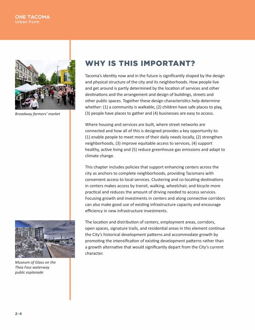
WHY IS THIS IMPORTANT?Tacoma’s identity now and in the future is significantly shaped by the design and physical structure of the city and its neighborhoods. How people live and get around is partly determined by the location of services and other destinations and the arrangement and design of buildings, streets and other public spaces. Together these design characteristics help determine whether: (1) a community is walkable, (2) children have safe places to play, (3) people have places to gather and (4) businesses are easy to access.
Where housing and services are built, where street networks are connected and how all of this is designed provides a key opportunity to: (1) enable people to meet more of their daily needs locally, (2) strengthen neighborhoods, (3) improve equitable access to services, (4) support healthy, active living and (5) reduce greenhouse gas emissions and adapt to climate change.
This chapter includes policies that support enhancing centers across the city as anchors to complete neighborhoods, providing Tacomans with convenient access to local services. Clustering and co-locating destinations in centers makes access by transit, walking, wheelchair, and bicycle more practical and reduces the amount of driving needed to access services. Focusing growth and investments in centers and along connective corridors can also make good use of existing infrastructure capacity and encourage efficiency in new infrastructure investments.
The location and distribution of centers, employment areas, corridors, open spaces, signature trails, and residential areas in this element continue the City’s historical development patterns and accommodate growth by promoting the intensification of existing development patterns rather than a growth alternative that would significantly depart from the City’s current character.
Broadway farmers’ market
Museum of Glass on the Thea Foss waterway public esplanade
2-5
One TacomaUrban Form
GOALS + POLICIES
CITYWIDE DESIGN + DEVELOPMENT
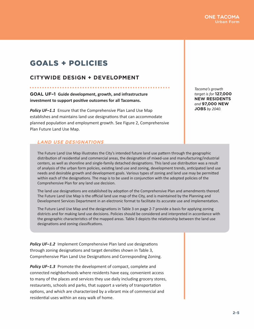
GOAL UF–1 Guide development, growth, and infrastructure investment to support positive outcomes for all Tacomans.
Policy UF–1.1 Ensure that the Comprehensive Plan Land Use Map establishes and maintains land use designations that can accommodate planned population and employment growth. See Figure 2, Comprehensive Plan Future Land Use Map.
Policy UF–1.2 Implement Comprehensive Plan land use designations through zoning designations and target densities shown in Table 3, Comprehensive Plan Land Use Designations and Corresponding Zoning.
Policy UF–1.3 Promote the development of compact, complete and connected neighborhoods where residents have easy, convenient access to many of the places and services they use daily including grocery stores, restaurants, schools and parks, that support a variety of transportation options, and which are characterized by a vibrant mix of commercial and residential uses within an easy walk of home.
Tacoma’s growth target is for 127,000 NEW RESIDENTS and 97,000 NEW JOBS by 2040�
The Future Land Use Map illustrates the City’s intended future land use pattern through the geographic distribution of residential and commercial areas, the designation of mixed-use and manufacturing/industrial centers, as well as shoreline and single-family detached designations. This land use distribution was a result of analysis of the urban form policies, existing land use and zoning, development trends, anticipated land use needs and desirable growth and development goals. Various types of zoning and land use may be permitted within each of the designations. The map is to be used in conjunction with the adopted policies of the Comprehensive Plan for any land use decision.
The land use designations are established by adoption of the Comprehensive Plan and amendments thereof. The Future Land Use Map is the official land use map of the City, and is maintained by the Planning and Development Services Department in an electronic format to facilitate its accurate use and implementation.
The Future Land Use Map and the designations in Table 3 on page 2-7 provide a basis for applying zoning districts and for making land use decisions. Policies should be considered and interpreted in accordance with the geographic characteristics of the mapped areas. Table 3 depicts the relationship between the land use designations and zoning classifications.
LAND USE DESIGNATIONS

2-6
One TacomaUrban Form
FIGURE 2. Comprehensive Plan Future Land Use Map
2-7
One TacomaUrban Form
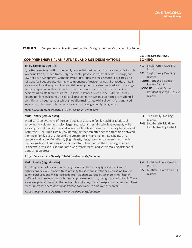
TABLE 3. Comprehensive Plan Future Land Use Designations and Corresponding Zoning
COMPREHENSIVE PLAN FUTURE LAND USE DESIGNATIONSCORRESPONDING ZONING
Single Family ResidentialQualities associated with single-family residential designations that are desirable include: low noise levels, limited traffic, large setbacks, private yards, small scale buildings, and low-density development. Community facilities, such as parks, schools, day cares, and religious facilities are also desirable components of residential neighborhoods. Limited allowances for other types of residential development are also provided for in the singe family designation with additional review to ensure compatibility with the desired, overarching single-family character. In some instances, such as the HMR-SRD, areas designated for single family residential development have an historic mix of residential densities and housing types which should be maintained while allowing for continued expansion of housing options consistent with the single family designation.
Target Development Density: 6–12 dwelling units/net acre
R-1 Single-Family Dwelling District
R-2 Single-Family Dwelling District
R-2SRD Residential Special Review District
HMR-SRD Historic Mixed Residential Special Review District
Multi-Family (low-density)This district enjoys many of the same qualities as single-family neighborhoods such as low traffic volumes and noise, larger setbacks, and small-scale development, while allowing for multi-family uses and increased density along with community facilities and institutions. The Multi-Family (low-density) district can often act as a transition between the single-family designation and the greater density and higher intensity uses that can be found in the Multi-Family (high density designation) or commercial or mixed-use designations. This designation is more transit-supportive than the Single Family Residential areas and is appropriate along transit routes and within walking distance of transit station areas.
Target Development Density: 14–36 dwelling units/net acre
R-3 Two-Family Dwelling District
R-4L Low-Density Multiple-Family Dwelling District
Multi-Family (high-density)This designation allows for a wide range of residential housing types at medium and higher density levels, along with community facilities and institutions, and some limited commercial uses and mixed-use buildings. It is characterized by taller buildings, higher traffic volumes, reduced setbacks, limited private yard space, and greater noise levels. These areas are generally found in the central city and along major transportation corridors where there is increased access to public transportation and to employment centers.
Target Development Density: 45–75 dwelling units/net acre
R-4 Multiple-Family Dwelling District
R-5 Multiple-Family Dwelling District
2-8
One TacomaUrban Form
COMPREHENSIVE PLAN FUTURE LAND USE DESIGNATIONSCORRESPONDING ZONING
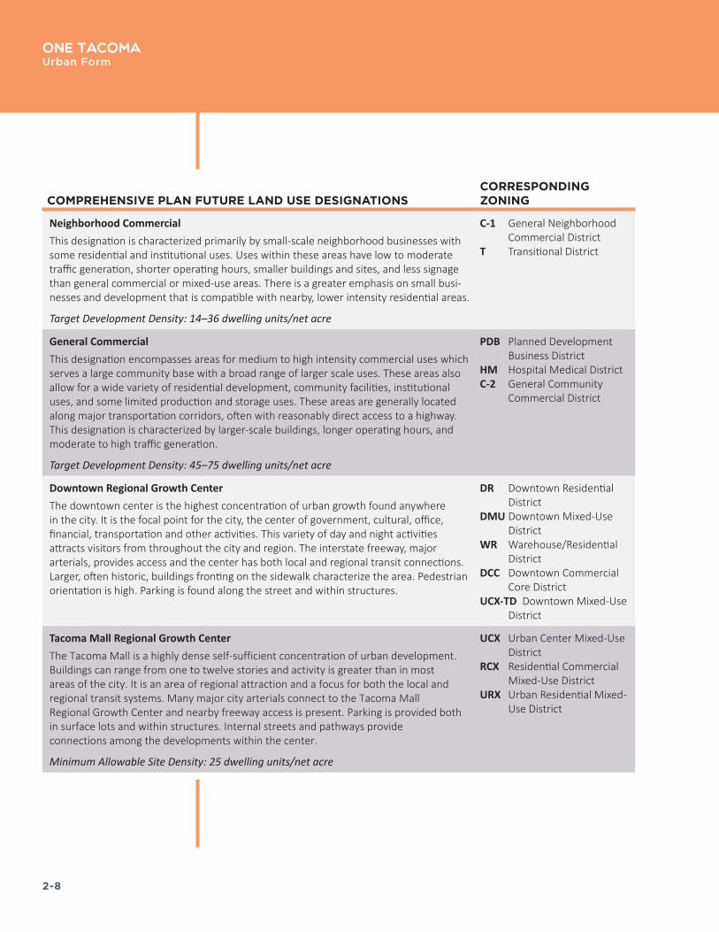
Neighborhood CommercialThis designation is characterized primarily by small-scale neighborhood businesses with some residential and institutional uses. Uses within these areas have low to moderate traffic generation, shorter operating hours, smaller buildings and sites, and less signage than general commercial or mixed-use areas. There is a greater emphasis on small busi‐nesses and development that is compatible with nearby, lower intensity residential areas.
Target Development Density: 14–36 dwelling units/net acre
C-1 General Neighborhood Commercial District
T Transitional District
General CommercialThis designation encompasses areas for medium to high intensity commercial uses which serves a large community base with a broad range of larger scale uses. These areas also allow for a wide variety of residential development, community facilities, institutional uses, and some limited production and storage uses. These areas are generally located along major transportation corridors, often with reasonably direct access to a highway. This designation is characterized by larger-scale buildings, longer operating hours, and moderate to high traffic generation.
Target Development Density: 45–75 dwelling units/net acre
PDB Planned Development Business District
HM Hospital Medical DistrictC-2 General Community
Commercial District
Downtown Regional Growth CenterThe downtown center is the highest concentration of urban growth found anywhere in the city. It is the focal point for the city, the center of government, cultural, office, financial, transportation and other activities. This variety of day and night activities attracts visitors from throughout the city and region. The interstate freeway, major arterials, provides access and the center has both local and regional transit connections. Larger, often historic, buildings fronting on the sidewalk characterize the area. Pedestrian orientation is high. Parking is found along the street and within structures.
DR Downtown Residential District
DMU Downtown Mixed-Use District
WR Warehouse/Residential District
DCC Downtown Commercial Core District
UCX-TD Downtown Mixed-Use District
Tacoma Mall Regional Growth CenterThe Tacoma Mall is a highly dense self-sufficient concentration of urban development. Buildings can range from one to twelve stories and activity is greater than in most areas of the city. It is an area of regional attraction and a focus for both the local and regional transit systems. Many major city arterials connect to the Tacoma Mall Regional Growth Center and nearby freeway access is present. Parking is provided both in surface lots and within structures. Internal streets and pathways provide connections among the developments within the center.
Minimum Allowable Site Density: 25 dwelling units/net acre
UCX Urban Center Mixed-Use District
RCX Residential Commercial Mixed-Use District
URX Urban Residential Mixed-Use District

2-9
One TacomaUrban Form
COMPREHENSIVE PLAN FUTURE LAND USE DESIGNATIONSCORRESPONDING ZONING
Crossroads CenterThe crossroads center is a concentration of commercial and/or institutional development that serves many nearby neighborhoods and generally includes a unique attraction that draws people from throughout the city. Some residential development may already be present, and there is a goal to have more residential development. It is directly accessible by arterials and local transit. Pedestrian accessibility is important within the center, but because of its focus on larger scale commercial development, the crossroads center continues to provide for automobile parking, preferably within structures.
Minimum Allowable Development Density: 25 dwelling units/net acre
CCX Community Commercial Mixed-Use District
RCX Residential Commercial Mixed-Use District
HMX Hospital Medical Mixed-Use District
URX Urban Residential Mixed-Use District
Neighborhood CenterThe neighborhood center is a concentrated mix of small- to medium-scale development that serves the daily needs of center residents, the immediate neighborhood, and areas beyond. Development contains a mix of residential and commercial uses, and the majority of parking is provided within structures. Buildings are generally up to six stories along the commercial corridors, up to three stories at the periphery of the centers near single-family districts, and up to four stories in areas between the core and the periphery. They are designed with a compatible character to adjacent residential neighborhoods. The design of the neighborhood center encourages pedestrians and bicyclists and its location on a major arterial makes it a convenient and frequent stop for local transit. The regional transit network also may directly serve some neighborhood centers.
Minimum Allowable Development Density: 25 dwelling units/net acre
NCX Neighborhood Commercial Mixed-Use District
RCX Residential Commercial Mixed-Use District
CIX Commercial Industrial Mixed-Use District
HMX Hospital Medical Mixed-Use District
URX Urban Residential Mixed-Use District
NRX Neighborhood Residential Mixed-Use District
Light IndustrialThis designation allows for a variety of industrial uses that are moderate in scale and impact, with lower noise, odors and traffic generation than heavy industrial uses. This designation may include various types of light manufacturing and warehousing and newer, clean and high-tech industries, along with commercial and some limited residential uses. These areas are often utilized as a buffer or transition between heavy industrial areas and less intensive commercial and/or residential areas.
M-1 Light Industrial District
Heavy IndustrialThis designation is characterized by higher levels of noise and odors, large-scale production, large buildings and sites, extended operating hours, and heavy truck traffic. This designation requires access to major transportation corridors, often including heavy-haul truck routes and rail facilities. Commercial and institutional uses are limited and residential uses are generally prohibited.
M-2 Heavy Industrial DistrictPMI Port Maritime & Industrial
District
2-10
One TacomaUrban Form
COMPREHENSIVE PLAN FUTURE LAND USE DESIGNATIONSCORRESPONDING ZONING
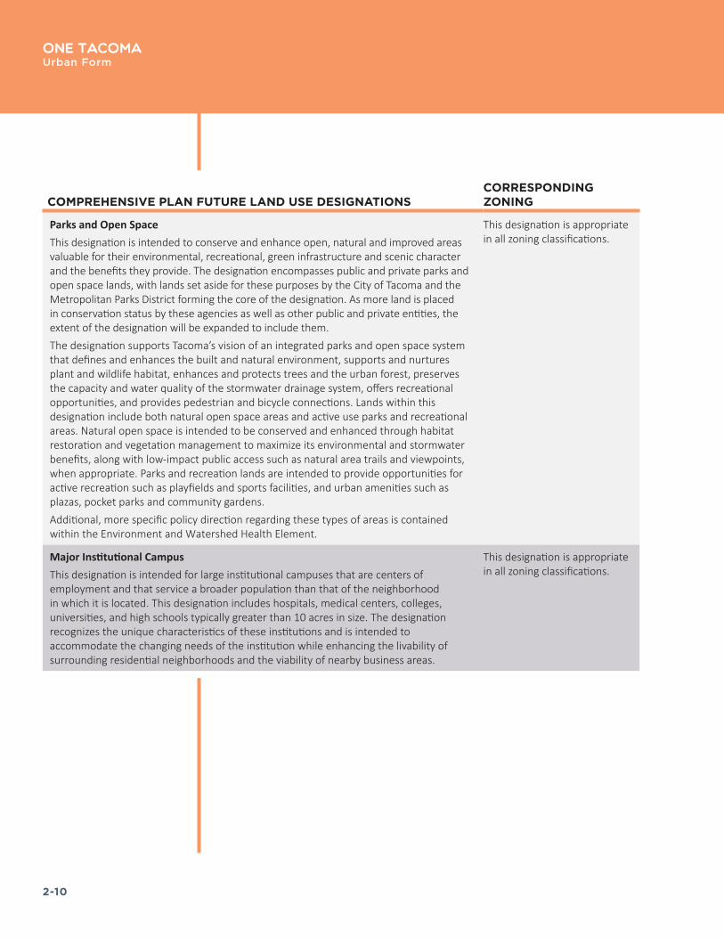
Parks and Open SpaceThis designation is intended to conserve and enhance open, natural and improved areas valuable for their environmental, recreational, green infrastructure and scenic character and the benefits they provide. The designation encompasses public and private parks and open space lands, with lands set aside for these purposes by the City of Tacoma and the Metropolitan Parks District forming the core of the designation. As more land is placed in conservation status by these agencies as well as other public and private entities, the extent of the designation will be expanded to include them.The designation supports Tacoma’s vision of an integrated parks and open space system that defines and enhances the built and natural environment, supports and nurtures plant and wildlife habitat, enhances and protects trees and the urban forest, preserves the capacity and water quality of the stormwater drainage system, offers recreational opportunities, and provides pedestrian and bicycle connections. Lands within this designation include both natural open space areas and active use parks and recreational areas. Natural open space is intended to be conserved and enhanced through habitat restoration and vegetation management to maximize its environmental and stormwater benefits, along with low-impact public access such as natural area trails and viewpoints, when appropriate. Parks and recreation lands are intended to provide opportunities for active recreation such as playfields and sports facilities, and urban amenities such as plazas, pocket parks and community gardens.Additional, more specific policy direction regarding these types of areas is contained within the Environment and Watershed Health Element.
This designation is appropriate in all zoning classifications.
Major Institutional CampusThis designation is intended for large institutional campuses that are centers of employment and that service a broader population than that of the neighborhood in which it is located. This designation includes hospitals, medical centers, colleges, universities, and high schools typically greater than 10 acres in size. The designation recognizes the unique characteristics of these institutions and is intended to accommodate the changing needs of the institution while enhancing the livability of surrounding residential neighborhoods and the viability of nearby business areas.
This designation is appropriate in all zoning classifications.

2-11
One TacomaUrban Form
COMPREHENSIVE PLAN FUTURE LAND USE DESIGNATIONSCORRESPONDING ZONING
ShorelineThe city’s shoreline areas provide great social, ecological, recreational, cultural, economic and aesthetic value, both at the local and regional level. It is the community’s intent to use the full potential of these areas in a manner that is both ordered and diversified, supports the community’s ability to enjoy the water and the unique setting it creates, and which integrates water and shoreline uses while achieving a net gain of ecological functions. In addition, these areas are intended to balance the overarching goals outlined in the State Shoreline Management Act:
• To ensure an adequate land supply for water-dependent uses;• To promote and enhance the public’s opportunities to access and enjoy the water; and• To protect and preserve natural resources.
This designation includes areas that support deepwater port and industrial sites, habitat for a variety of fish and wildlife, archaeological and historical sites, open space, recreation and community activities, and some commercial and residential development. Recognizing the limited nature of this important resource, use and development of the shoreline areas must be carefully planned and regulated to ensure that these values are maintained over time.The Shoreline Master Program has been developed to provide additional and more detailed policy direction regarding the city’s shoreline areas, along with specific zoning and development standards. The Shoreline Master Program utilizes a system of “environment designations” which further guide the character, intensity and use of individual shoreline segments. These classifications include Natural, Shoreline Residential, Urban Conservancy, High Intensity, Aquatic, and Downtown Waterfront and are based on the existing development patterns, natural capabilities and goals and aspirations of the community for its shoreline areas.
S1–S14 Shoreline Zoning Districts
Policy UF–1.4 Direct the majority of growth and change to centers, corridors, and transit station areas, allowing the continuation of the general scale and characteristics of Tacoma’s residential areas.
Policy UF–1.6 Support energy-efficient, resource-efficient, and sustainable development and transportation patterns through land use and transportation planning.
Policy UF–1.7 Integrate nature and use appropriate green infrastructure throughout Tacoma.
Policy UF-1.8 Recognize the importance of the city's established street grid pattern, block sizes, and intersection density in supporting multi-modal transportation, quality urban design, and 20-minute neighborhoods. Whenever practicable, the established grid pattern should be preserved and enhanced to achieve the city's goals for urban form, and design and development.
Policy UF-1.5 Strive for a built environment designed to provide a safe, healthful, and attractive environment for people of all ages and abilities.

2-12
One TacomaUrban Form
Policy UF–1.9 Encourage high quality design and development that demonstrates Tacoma’s leadership in the design of the built environment, commitment to a more equitable city, and ability to experiment and generate innovative design solutions.
Policy UF–1.10 Leverage the power of the arts, culture and creativity to serve the community’s interest while driving growth in a way that builds character and quality of place.
Policy UF–1.11 Evaluate the impacts of land use decisions on the physical characteristics of neighborhoods and current residents, particularly under-served and under-represented communities.
a. Avoid or reduce negative development impacts, especially wherethose impacts inequitably burden communities of color under-served and under-represented communities, and other vulnerablepopulations.
b. Make needed investments in areas that are deficient ininfrastructure and services to reduce disparities and increase equityand where growth and change are anticipated.
Policy UF–1.12 Plan for future annexation of the city’s Potential Annexation Areas (PAA) in a collaborative manner with affected jurisdictions and residents.
CENTERS
Centers are compact, walkable and pedestrian-oriented urban places. They are connected by public transit and active transportation networks. They anchor complete neighborhoods with retail stores and businesses (grocery stores, restaurants, markets, shops, etc.) civic amenities (libraries, schools, community centers, places of worship, etc.), housing options, health clinics, daycare centers, employment centers, plazas and parks and other public gathering places.
Centers will be the primary areas for growth and change in Tacoma over the next 25 years. Focusing new growth in centers helps achieve goals of having more Tacomans live in complete neighborhoods, use public transit and active transportation—walking, biking and rolling—to commute to work and complete errands, and it will help mitigate and prepare for the effects of climate change. Clustering and co-locating destinations and
Hill climb assist through UW Tacoma
See the Public Facilities + Services Element
for additional policies related to annexation under Goal PFS–2 and
supporting policies

2-13
One TacomaUrban Form
housing within compact, walkable centers makes access by transit, walking, wheelchair, and bicycle more practical and reduces the amount of driving needed to access services, reducing the impact on roadways, reducing congestion, and facilitating freight movement.
Centers range in scale from the Tacoma’s Downtown to small neighborhood storefront service nodes, providing local access to services and allowing Tacomans across the City to live a healthy, active lifestyle. Neighborhood business districts and the commercial services they provide are the foundation of many centers, but centers, particularly larger centers, will also become a focus for public services, gathering places, and housing growth. In and around all centers, there will be change as areas urbanize and new services, shops and housing are developed.
Four types of centers are designated that vary in size, scale, service area, role, and density of residents and businesses. As shown in Figure 3, the four types of centers are:
• Downtown Regional Growth Center
• Tacoma Mall Regional Growth Center
• Crossroads Center
• Neighborhood Center
Policies in this section identify essential elements and functions of centers that will be enhanced over time. Additional policies provide more detailed direction for specific types of centers.
GOAL UF–2 Focus growth in a citywide network of centers that provide healthy, equitable and sustainable access to services and housing and preserve the city’s character and sense of place.
Policy UF–2.1 Plan for a range of centers across the city to enhance local, equitable access to services, employment, and housing opportunities.
Policy UF–2.2 Connect centers to each other and to other key destinations, such as schools and parks, by frequent and convenient transit, bicycle sharing, bicycle routes, pedestrian trails and sidewalks, and electric and vehicle charging stations.
MLK Jr. Way, a commercial corridor in the Hilltop
Neighborhood
Commerce Street transfer area

2-14
One TacomaUrban Form
FIGURE 3. Mixed-use Centers

2-15
One TacomaUrban Form
Policy UF–2.3 When planning capital and transportation improvements in centers, consider the following priorities:
a. Focus and coordinate investments in one or two centers formaximum effect;
b. Focus investments in centers where the real estate market isemerging and where public efforts would likely stimulate privateinvestment;
c. Identify and respond to special needs and opportunities in centers,including possible level of service deficiencies.
Policy UF–2.4 Strictly limit the expansion of the mixed-use center boundaries except where it can be shown that the center has maximized its development potential, has achieved a full range of uses, and the proposed area of expansion will be developed to the fullest extent possible.
a. Support boundary expansion only when a center demonstrates asustained level of growth consistent with the centers strategy andplanned densities, where the demand for additional growth exists,and where the capacity for additional growth is limited.
GOAL UF–3 Enhance centers as anchors of complete neighborhoods that include concentrations of commercial and public services, housing, employment, gathering places, and green spaces.
Policy UF–3.1 Design centers to be compact, safe, attractive, and accessible places, where the street environment makes access by transit, walking, biking, and mobility devices, such as wheelchairs, safe and attractive for people of all ages and abilities.
Policy UF–3.2 Provide housing capacity for enough population to support a broad range of commercial services, focusing higher-density housing within a half-mile of the core.
Policy UF–3.3 Encourage residential development for mixed income levels in all centers.

2-16
One TacomaUrban Form
Policy UF–3.4 Encourage the placement of services in centers, including schools and colleges, health services, community centers, daycare, parks and plazas, library services, and justice services.
Policy UF–3.5 Ensure that land use plans and infrastructure investments allow for and incorporate arts and culture as central components of centers and as identity forming creative processes.
Policy UF–3.6 Encourage public and private investment in infrastructure, economic development, and community services in centers to ensure that all centers will support the populations they serve.
Policy UF–3.7 Partner with Pierce Transit in providing development incentives and programs to improve transit-orientation and walking conditions in all centers.
Policy UF–3.8 Partner with employers within mixed-use centers to reduce dependence on automobile use and increase the use of transit, ridesharing, and non-motorized transportation modes through aggressive implementation of Commute Trip Reduction programs and other efforts.
Policy UF–3.9 Where existing development patterns allow, mixed-use centers should include areas outside of the core where commercial uses are restricted and low rise multifamily development that is more compatible with the scale, massing and form of adjacent single family development is emphasized.
Policy UF–3.10 Integrate nature and green infrastructure into centers and enhance public views and connections to the surrounding natural features.
Renovated Albers Mill Lofts building on the Thea Foss Waterway
Trail at E 48th and R streets in the Salishan neighborhood
Rain gardens and landscaping on Pacific Avenue

2-17
One TacomaUrban Form
DOWNTOWN TACOMA REGIONAL GROWTH CENTER
The Downtown Regional Growth Center is the highest concentration of urban growth found anywhere in the city. It is the focal point for the city, the center of government, cultural, office, financial, transportation and other activities with a variety of day and night activities that attracts visitors from throughout the city and region. The interstate freeway and major arterials provides access and the center has both local and regional transit connections. Larger, often historic, buildings fronting on the sidewalk characterize the area. Pedestrian orientation is high and consideration for pedestrians is paramount.
The Downtown zoning districts are the most intensive in the city, allowing development heights from 90 feet in the Downtown Residential District to 400 feet in the Downtown Commercial Core. The Downtown Regional Center subarea plans have been developed in accordance with the Growing Transit Communities Compact and zoning capacity is sufficient to accommodate planned growth of 76,200 new residents and 67,900 new jobs by 2040.
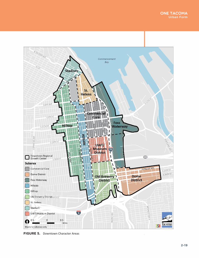
Downtown Tacoma Regional Growth Center is comprised of diverse neighborhoods and districts (see Figure 4 and Figure 5 on the following pages). New development should be sensitive to the context of these neighborhoods and districts and build on the strengths and character of these established areas, per the policies in the Downtown Element and the Downtown Tacoma Subarea Plans.
Downtown Core
With the highest intensity of urban uses in Tacoma, the Downtown Core functions as the center for governmental, cultural, business, and financial activities. The area is the visual and commercial focal point for the city and offers a variety of daytime and nighttime activities for locals and visitors, such as theater, art galleries, shopping, waterfront access, outdoor recreation and dining. The principal retail corridors are located along Pacific Avenue and Broadway south of 7th Avenue. The Downtown Core is the hub for important local and regional transit connections, including Tacoma LINK light rail and the Commerce Street Transit Center.
Commerce Street serves as a transit hub in North Downtown
Theater Square
Columbia Bank building in the Downtown Core
Downtown Core
Pacific Avenue

2-18
One TacomaUrban Form
FIGURE 4. Downtown Regional Growth Center Subareas
2-19
One TacomaUrban Form
FIGURE 5. Downtown Character Areas
2-20
One TacomaUrban Form
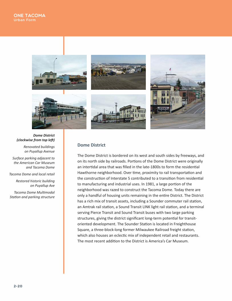
Dome District
The Dome District is bordered on its west and south sides by freeways, and on its north side by railroads. Portions of the Dome District were originally an intertidal area that was filled in the late-1800s to form the residential Hawthorne neighborhood. Over time, proximity to rail transportation and the construction of Interstate 5 contributed to a transition from residential to manufacturing and industrial uses. In 1981, a large portion of the neighborhood was razed to construct the Tacoma Dome. Today there are only a handful of housing units remaining in the entire District. The District has a rich mix of transit assets, including a Sounder commuter rail station, an Amtrak rail station, a Sound Transit LINK light rail station, and a terminal serving Pierce Transit and Sound Transit buses with two large parking structures, giving the district significant long-term potential for transit-oriented development. The Sounder Station is located in Freighthouse Square, a three-block-long former Milwaukee Railroad freight station, which also houses an eclectic mix of independent retail and restaurants. The most recent addition to the District is America’s Car Museum.
Dome District (clockwise from top left)
Renovated buildings on Puyallup Avenue
Surface parking adjacent to the American Car Museum
and Tacoma Dome
Tacoma Dome and local retail
Restored historic building on Puyallup Ave
Tacoma Dome Multimodal Station and parking structure

2-21
One TacomaUrban Form
Brewery District
The Brewery district is named for the historic breweries built in the area starting in the late 19th Century. Although none of the original breweries are still operating, many of the historic red brick buildings remain, creating a distinct architectural character for the District. During the first few decades of the 20th Century, a variety of retail, service, and industrial establishments were built in the Brewery District, creating the gritty commercial character that persists to this day. The Brewery District is situated between the UWT/ Museum District and the Dome District, it and has the potential to serve as an important connector between them. There is currently very little housing in the Brewery District, with the exception of a small residential area known as Knob Hill located in the southwest corner of the District. There is also a relatively high amount of vacant or underutilized property that presents numerous opportunities for redevelopment, such as adaptive re-use and farmers’ markets.
Brewery District (clockwise from top left)
Retail district character
Hunt Mottet Lofts, a historic masonry building
Jefferson Square, affordable housing managed by the Tacoma Rescue Mission
1911 Nisqually Power Plant substation
Holgate Street

2-22
One Tacoma Urban Form
UWT/Museum District
This District encompasses the 46-acre University of Washington Tacoma (UWT) campus, as well as several major institutions, including the Tacoma Art Museum, the Children’s Museum of Tacoma, the Washington State History Museum, the Museum of Glass, the Greater Tacoma Convention and Trade Center, and historic Union Station, which now houses a U.S. District Court after an award-winning restoration in the 1990s. Established in 1990, the UWT campus has undergone an extraordinary transformation, earning numerous awards for the adaptive reuse of several century-old, brick railroad-era structures into modern classroom facilities. UWT has plans for continued large-scale expansion that will be a major driver for economic development in the area.
UWT/Museum District (clockwise from top left)
UWT in a rehabilitated historical building
Union Station (U.S. District Court) and LINK light rail
Tacoma Art Museum

2-23
One TacomaUrban Form
St. Helens Neighborhood
St. Helens is a medium-density mixed-use neighborhood that looks out over the Thea Foss Waterway and provides a transition between the historic civic center of the Downtown Core and the more residential Stadium District on the bluff above. With its successful retail core along St. Helens Avenue, the neighborhood is home to an array of businesses and multi-family residential buildings, both condominiums and apartments.
St. Helens Neighborhood (clockwise from top left)
Goddess of Commerce statue
Condominiums on S 6th Ave
St� Helens Avenue in North Downtown is a good example of a street designed to serve multiple mobility functions
Tacoma’s First Presbyterian Church, designed by famous church architect Ralph Adams Cram
Retail district character
2-24
One TacomaUrban Form
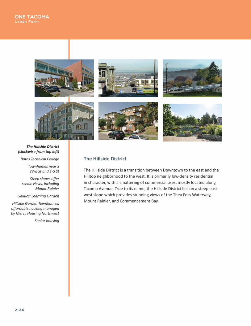
The Hillside District
The Hillside District is a transition between Downtown to the east and the Hilltop neighborhood to the west. It is primarily low-density residential in character, with a smattering of commercial uses, mostly located along Tacoma Avenue. True to its name, the Hillside District lies on a steep east-west slope which provides stunning views of the Thea Foss Waterway, Mount Rainier, and Commencement Bay.
The Hillside District (clockwise from top left)
Bates Technical College
Townhomes near S 23rd St and S G St
Steep slopes offer scenic views, including
Mount Rainier
Gallucci Learning Garden
Hillside Garden Townhomes, affordable housing managed by Mercy Housing Northwest
Senior housing
2-25
One TacomaUrban Form
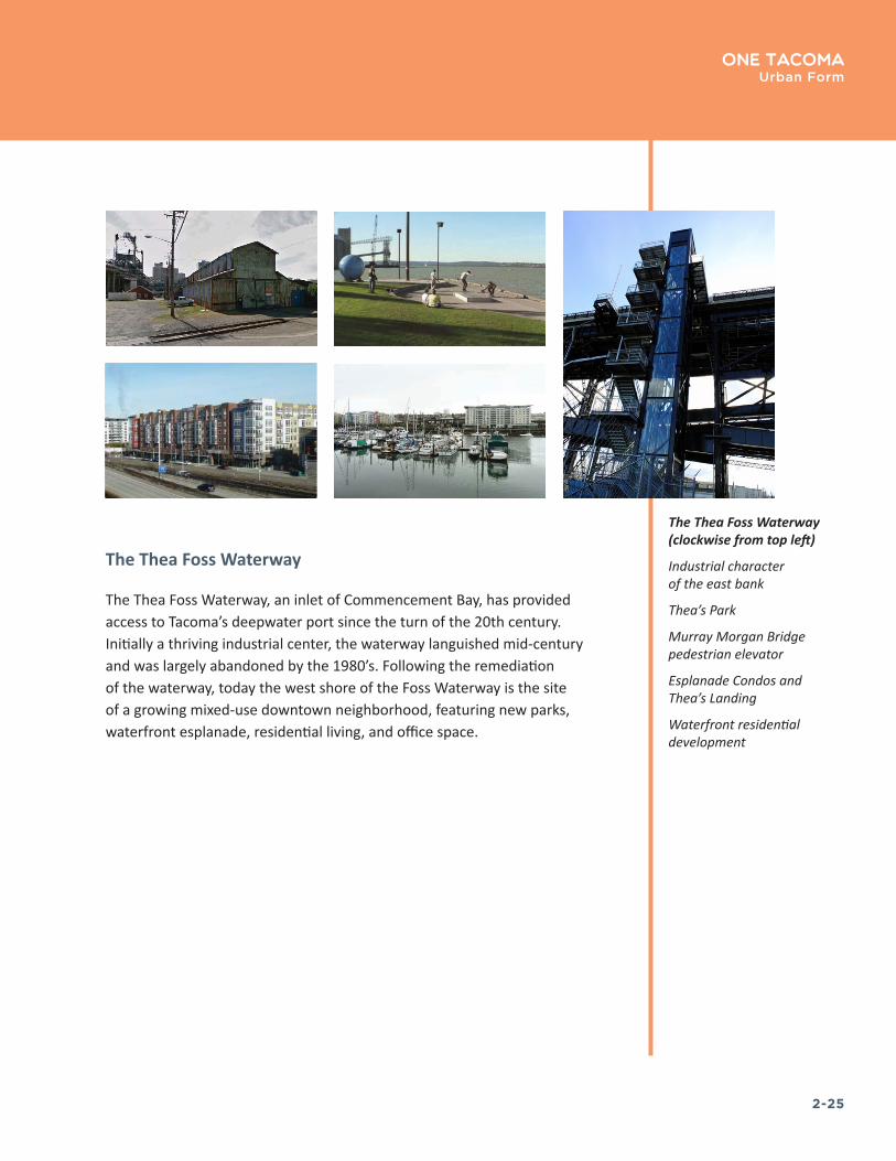
The Thea Foss Waterway
The Thea Foss Waterway, an inlet of Commencement Bay, has provided access to Tacoma’s deepwater port since the turn of the 20th century. Initially a thriving industrial center, the waterway languished mid-century and was largely abandoned by the 1980’s. Following the remediation of the waterway, today the west shore of the Foss Waterway is the site of a growing mixed-use downtown neighborhood, featuring new parks, waterfront esplanade, residential living, and office space.
The Thea Foss Waterway (clockwise from top left)
Industrial character of the east bank
Thea’s Park
Murray Morgan Bridge pedestrian elevator
Esplanade Condos and Thea’s Landing
Waterfront residential development

2-26
One TacomaUrban Form
Stadium District
The Stadium District is located just north of Tacoma’s downtown commercial core, adjacent to the North Slope and Hilltop neighborhoods to the west and the north. The district is named after Stadium High School, an architectural and historic icon which has been operating within the Tacoma School District for more than 100 years.
The district is situated on a bluff overlooking Commencement Bay and is significantly higher in elevation than much of the Downtown Core area. The neighborhood is located adjacent to Wright Park and the Seymour Conservatory and is home to a mix of retail and service businesses that meet the daily needs of the area’s large population of apartment-dwelling residents.
Stadium District (clockwise from top left)
Historic Stadium High School
Locally-owned retail
Multifamily housing
Neighborhood-scale commercial development
Single family housing
2-27
One TacomaUrban Form
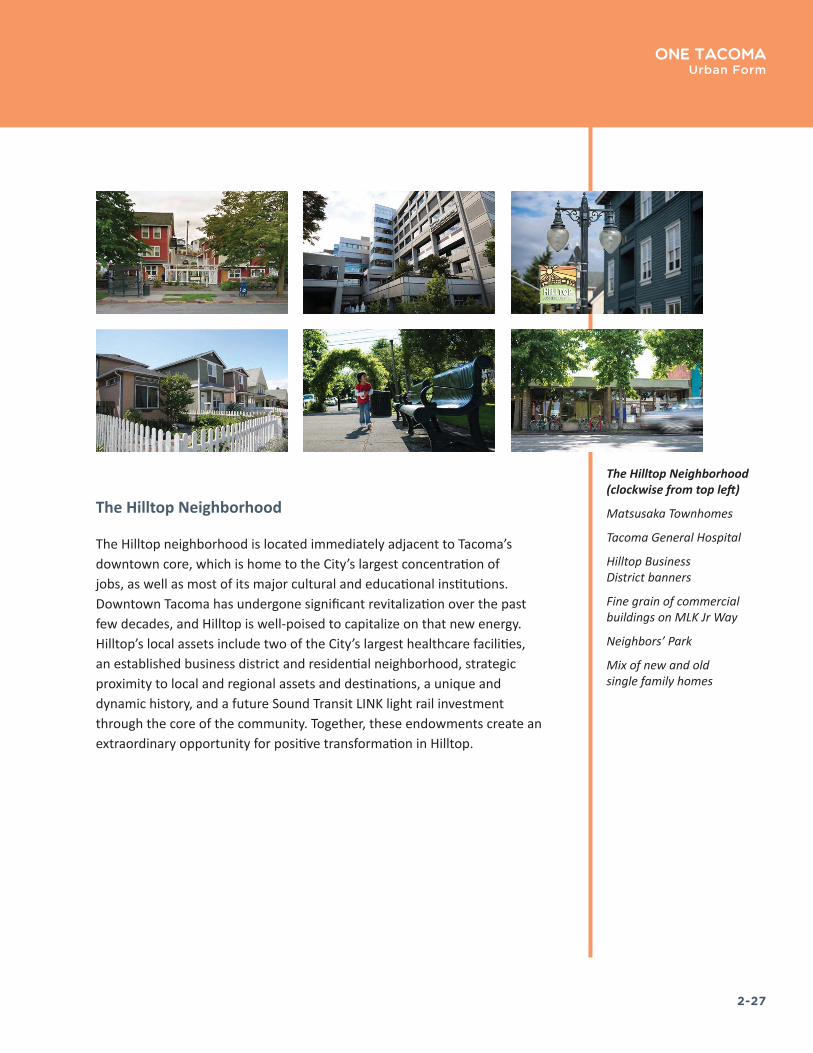
The Hilltop Neighborhood
The Hilltop neighborhood is located immediately adjacent to Tacoma’s downtown core, which is home to the City’s largest concentration of jobs, as well as most of its major cultural and educational institutions. Downtown Tacoma has undergone significant revitalization over the past few decades, and Hilltop is well-poised to capitalize on that new energy. Hilltop’s local assets include two of the City’s largest healthcare facilities, an established business district and residential neighborhood, strategic proximity to local and regional assets and destinations, a unique and dynamic history, and a future Sound Transit LINK light rail investment through the core of the community. Together, these endowments create an extraordinary opportunity for positive transformation in Hilltop.
The Hilltop Neighborhood (clockwise from top left)
Matsusaka Townhomes
Tacoma General Hospital
Hilltop Business District banners
Fine grain of commercial buildings on MLK Jr Way
Neighbors’ Park
Mix of new and old single family homes
2-28
One TacomaUrban Form
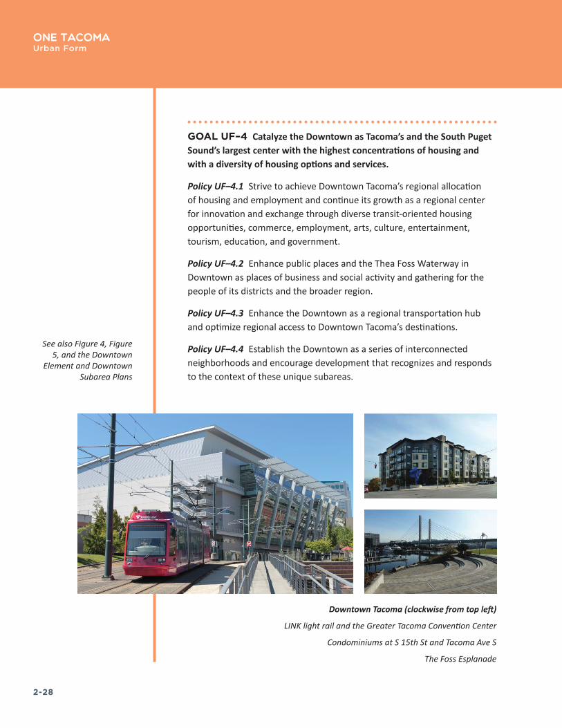
GOAL UF–4 Catalyze the Downtown as Tacoma’s and the South Puget Sound’s largest center with the highest concentrations of housing and with a diversity of housing options and services.
Policy UF–4.1 Strive to achieve Downtown Tacoma’s regional allocation of housing and employment and continue its growth as a regional center for innovation and exchange through diverse transit-oriented housing opportunities, commerce, employment, arts, culture, entertainment, tourism, education, and government.
Policy UF–4.2 Enhance public places and the Thea Foss Waterway in Downtown as places of business and social activity and gathering for the people of its districts and the broader region.
Policy UF–4.3 Enhance the Downtown as a regional transportation hub and optimize regional access to Downtown Tacoma’s destinations.
Policy UF–4.4 Establish the Downtown as a series of interconnected neighborhoods and encourage development that recognizes and responds to the context of these unique subareas.
See also Figure 4, Figure 5, and the Downtown
Element and Downtown Subarea Plans
Downtown Tacoma (clockwise from top left)
LINK light rail and the Greater Tacoma Convention Center
Condominiums at S 15th St and Tacoma Ave S
The Foss Esplanade
2-29
One TacomaUrban Form
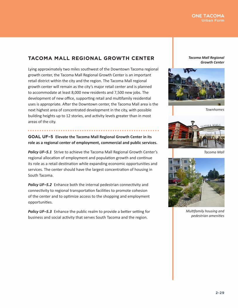
TACOMA MALL REGIONAL GROWTH CENTER
Lying approximately two miles southwest of the Downtown Tacoma regional growth center, the Tacoma Mall Regional Growth Center is an important retail district within the city and the region. The Tacoma Mall regional growth center will remain as the city’s major retail center and is planned to accommodate at least 8,000 new residents and 7,500 new jobs. The development of new office, supporting retail and multifamily residential uses is appropriate. After the Downtown center, the Tacoma Mall area is the next highest area of concentrated development in the city, with possible building heights up to 12 stories, and activity levels greater than in most areas of the city.
GOAL UF–5 Elevate the Tacoma Mall Regional Growth Center in its role as a regional center of employment, commercial and public services.
Policy UF–5.1 Strive to achieve the Tacoma Mall Regional Growth Center’s regional allocation of employment and population growth and continue its role as a retail destination while expanding economic opportunities and services. The center should have the largest concentration of housing in South Tacoma.
Policy UF–5.2 Enhance both the internal pedestrian connectivity and connectivity to regional transportation facilities to promote cohesion of the center and to optimize access to the shopping and employment opportunities.
Policy UF–5.3 Enhance the public realm to provide a better setting for business and social activity that serves South Tacoma and the region.
Townhomes
Tacoma Mall
Multifamily housing and pedestrian amenities
Tacoma Mall Regional Growth Center

2-30
One Tacoma Urban Form
CROSSROADS CENTERS
Crossroads Centers consist typically of commercial development focused at intersections of major arterials or highways. These are areas where a greater mix of uses, including significantly more residential use, is desired. Development within Crossroads Centers will be of smaller scale and less dense than developments within the Regional Growth Centers but still will be greater than found in areas surrounding the center. Crossroads centers are located throughout Tacoma to serve broad parts of the city. They are typically anchored by major employers, institutions, or full service grocery stores, and feature a wide range of commercial and community services. Development in Crossroads Centers is intended to be mid-rise in scale. Mid-rise development includes buildings from five to 8 stories in height, but most frequently ranging from five to six stories. Parking is typically located off street and internal to the development site. As the centers grow, large surface parking lots should transition to structured parking, to free additional space to be more efficiently used for new infill development. Parking lots should be designed to promote internal connectivity and walkability within the center.
Development of mid-rise multiple family development is anticipated within the core of Community Centers with townhomes and stacked flats at the edges. Overall, residential densities will vary depending on the characteristics of the center, location within the community and other factors. Individual site densities can range from about 25–42 units per net acre for townhomes and stacked flats to 60 units per net acre for mid-rise mixed-use structures. Densities of 25 units per net acre are envisioned for areas near single-family zones where building height should be limited to ensure compatibility. Higher densities are envisioned in other parts of the centers depending on the established height limit, with the highest densities occurring along pedestrian streets.
Westgate
The Westgate Crossroads Center consists of three parts: the Westgate North and South shopping centers and the residential and public land on the west side of Pearl Street. The two shopping centers are traditional neighborhood centers, anchored by grocery stores and serving a trade area within a one to three mile radius. Safeway anchors Westgate North
DESIGNATED CROSSROADS
CENTERS: Westgate
Lower Pacific Upper Pacific
Lower Portland Upper Portland
James Center Tacoma Central

2-31
One TacomaUrban Form
while Albertsons anchored Westgate South until its recent closure. Other businesses are a hardware store, drugstore, fast food restaurants and miscellaneous retail and service businesses. Residential development is largely multifamily in two and three story garden style apartment buildings to the northwest and southwest of the center. The area between is owned by the City of Tacoma and includes park land and a substation. Median home values are well above the average for the city as a whole while rents are lower. Median income is slightly above that for the city.
This is primarily an auto-oriented district, with strip malls set back from the street by large parking lots. The adjacent street grid is interrupted, forming large blocks with little connectivity.
Albertsons anchored the Westgate South shopping center but recently closed, now lacking a large commercial tenant. The lack of an anchor in Westgate South creates an opportunity for redevelopment for a broader mix of uses.
Lower Pacific
The Lower Pacific Crossroads Center is a retail and service center serving the surrounding residential areas and a wider trade area. The center features a balanced mix of commercial, residential, and institutional uses, including a Haggen’s grocery store, hospital, medical offices, medical related county offices, and auto-oriented retail. There are almost 200 housing units, 70% of which are single family. Pacific Avenue provides quick access to the downtown and a sufficiently high traffic volume to support regional retail business.
This district is situated on a plateau with views of Downtown and the Port of Tacoma Manufacturing and Industrial Center on the northern portion. Topography makes cycling difficult and there are no facilities servicing the district, although one east-west route is proposed along E 37th Street.
Bus routes #1, #53, and #54 serve this District with connections for Downtown and Tacoma Mall, linking 6th Avenue, Lincoln, Upper Pacific, James Center, and Lower Portland Mixed-use Centers (MUC). Sidewalks and pedestrian facilities are present but numerous parking lots line the street front and do not promote walkability along Pacific Avenue. Future
Streetscape and existing office space in Westgate
2-32
One Tacoma Urban Form
plans include potential High Capacity Transit or Streetcar service. Transit investments should be accompanied by streetscape improvements to better serve pedestrians and cyclists.
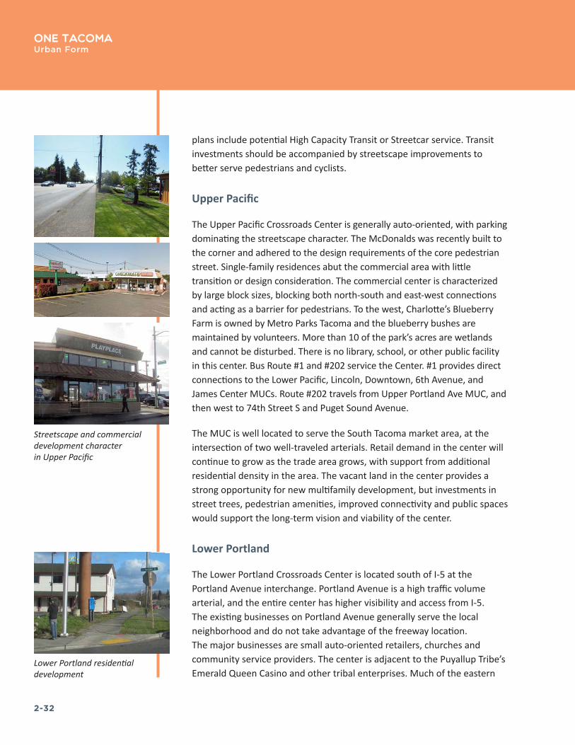
Upper Pacific
The Upper Pacific Crossroads Center is generally auto-oriented, with parking dominating the streetscape character. The McDonalds was recently built to the corner and adhered to the design requirements of the core pedestrian street. Single-family residences abut the commercial area with little transition or design consideration. The commercial center is characterized by large block sizes, blocking both north-south and east-west connections and acting as a barrier for pedestrians. To the west, Charlotte’s Blueberry Farm is owned by Metro Parks Tacoma and the blueberry bushes are maintained by volunteers. More than 10 of the park’s acres are wetlands and cannot be disturbed. There is no library, school, or other public facility in this center. Bus Route #1 and #202 service the Center. #1 provides direct connections to the Lower Pacific, Lincoln, Downtown, 6th Avenue, and James Center MUCs. Route #202 travels from Upper Portland Ave MUC, and then west to 74th Street S and Puget Sound Avenue.
The MUC is well located to serve the South Tacoma market area, at the intersection of two well-traveled arterials. Retail demand in the center will continue to grow as the trade area grows, with support from additional residential density in the area. The vacant land in the center provides a strong opportunity for new multifamily development, but investments in street trees, pedestrian amenities, improved connectivity and public spaces would support the long-term vision and viability of the center.
Lower Portland
The Lower Portland Crossroads Center is located south of I-5 at the Portland Avenue interchange. Portland Avenue is a high traffic volume arterial, and the entire center has higher visibility and access from I-5. The existing businesses on Portland Avenue generally serve the local neighborhood and do not take advantage of the freeway location. The major businesses are small auto-oriented retailers, churches and community service providers. The center is adjacent to the Puyallup Tribe’s Emerald Queen Casino and other tribal enterprises. Much of the eastern
Lower Portland residential development
Streetscape and commercial development character in Upper Pacific

2-33
One TacomaUrban Form
portion of the center is vacant in anticipation of future development by the Tribe. The portion of the center to the south and west features 120 mostly single family homes.
The street median improves E Portland Avenue’s aesthetics. Despite this, the streetscape remains an uninviting pedestrian experience. Billboards and arterial sized poles line the street and there is often no vegetated buffer between the sidewalk and vehicle traffic.
Future development of the center will be largely driven by plans by the Tribe. New development will likely take better advantage of the center’s freeway access and visibility. Larger scale retail should be supportable along Portland Avenue. With a base of lower priced single family homes, the area can be attractive to first-time home buyers looking for something affordable.
Upper Portland
The Upper Portland Crossroads Center features two shopping centers on the west side of 72nd. The 72nd Street square is anchored by Goodwill, and Tahoma Vista Center is anchored by K-Mart. Other major uses are the Covenant Celebration Church, several retirement homes, an office building occupied by the State Department of Social and Health Services, and a new convenience retail center with service businesses. The southeast quadrant of the intersection is outside the city limits, but provides an additional retail center. The Center serves the southeast Tacoma area as well as portions of unincorporated Pierce County. There are 275 housing units, most of which are single family residences. Median home values are well below the values for the city as a whole. The median income is lower than for the city as a whole as well.
Pedestrian conditions are poor. The streetscapes are uninviting and internal or mid-block connections are absent. The shopping centers are cut off from adjacent residential areas. Street improvements will be expensive relative to their benefit unless they are coordinated with substantial private investment.
In the immediate future, multifamily residential will likely be 2 and 3-story buildings with surface parking. The church’s parking area offers the only vacant land in the area. Unless these sites are made available, new development will have to occur on existing commercial and residential sites.
Lower Portland development character and transit
Commercial development character and transit
in Upper Portland
2-34
One Tacoma Urban Form
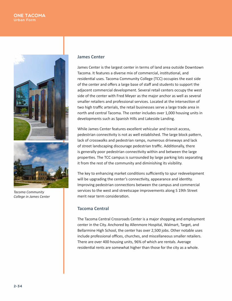
James Center
James Center is the largest center in terms of land area outside Downtown Tacoma. It features a diverse mix of commercial, institutional, and residential uses. Tacoma Community College (TCC) occupies the east side of the center and offers a large base of staff and students to support the adjacent commercial development. Several retail centers occupy the west side of the center with Fred Meyer as the major anchor as well as several smaller retailers and professional services. Located at the intersection of two high traffic arterials, the retail businesses serve a large trade area in north and central Tacoma. The center includes over 1,000 housing units in developments such as Spanish Hills and Lakeside Landing.
While James Center features excellent vehicular and transit access, pedestrian connectivity is not as well established. The large block pattern, lack of crosswalks and pedestrian ramps, numerous driveways and lack of street landscaping discourage pedestrian traffic. Additionally, there is generally poor pedestrian connectivity within and between the large properties. The TCC campus is surrounded by large parking lots separating it from the rest of the community and diminishing its visibility.
The key to enhancing market conditions sufficiently to spur redevelopment will be upgrading the center’s connectivity, appearance and identity. Improving pedestrian connections between the campus and commercial services to the west and streetscape improvements along S 19th Street merit near term consideration.
Tacoma Central
The Tacoma Central Crossroads Center is a major shopping and employment center in the City. Anchored by Allenmore Hospital, Walmart, Target, and Bellarmine High School, the center has over 2,500 jobs. Other notable uses include professional offices, churches, and miscellaneous smaller retailers. There are over 400 housing units, 96% of which are rentals. Average residential rents are somewhat higher than those for the city as a whole.
Tacoma Community College in James Center

2-35
One TacomaUrban Form
The development layout is quite different than the surrounding single-family neighborhoods. The large block size is broken by curvy roads with sidewalks on both sides of the street. With Franklin Park to the north and Snake Lake Park to the west, the center is well-served with open space.
The District is serviced by three buses. Route #2 connects Downtown to James Center and Route #57 connects to the Tacoma Mall. Route 51 travels north to 6th Avenue and Proctor. A potential High Capacity Transit route would be down 6th, touching the boundary of Narrows, going south down Pearl and then following 19th back to the City, thus connecting the 6th Avenue, Narrows, James Center and Tacoma Central MUCs.
GOAL UF–6 Establish Crossroads Centers as successful places that serve the needs of surrounding neighborhoods and a wider area and contain high concentrations of employment, institutions, commercial and community services, and a wide range of housing options.
Policy UF–6.1 Provide for a wide range of housing types in Crossroads Centers, which are intended to generally be larger in scale than the surrounding residential areas. The combined area of a Crossroads Center and the area within a half-mile walking distance of the Center should be able to accommodate a minimum of 5,000 households.
Policy UF–6.2 Improve Crossroads Centers as multimodal transportation hubs that optimize access from the broad area of the city they serve and are linked to the region’s high-capacity transit system.
Policy UF–6.3 Provide parks or public squares within or near Crossroads Centers to support their roles as places of focused business and social activity.

2-36
One Tacoma Urban Form
NEIGHBORHOOD CENTERS
Neighborhood Centers are smaller centers that include a mixture of higher density commercial and residential buildings, typically coinciding with historic business districts. Buildings generally are to reach no more than six stories and should be designed to be compatible with the character of existing buildings within the center. A main focus for the neighborhood center is to encourage pedestrians and bicyclists. The neighborhood center should be designed in such a fashion that the preferred modes of transportation are walking, bicycling, and public transit. This means that the neighborhood center should remain especially compact and that amenities such as bicycle racks, landscaping, lighting, and others should be prominent in order to make walking and bicycling desirable as well as practical. Parking will be available within neighborhood centers, but should be primarily on-street, within structures, or in small lots behind or adjacent to buildings. In most instances, the neighborhood center should develop into a “mini” transfer center for local transit. Some neighborhood centers also may be directly served by the regional transit network.
Proctor
The Proctor Neighborhood Center is what one thinks of as a “classic” neighborhood scale center with excellent local services and amenities, pleasant pedestrian streetscapes, and attractive buildings including notable public structures such as the Washington Elementary School building and the Wheelock Branch Library. The new Proctor Station development adds significant strength to the retail market and is in keeping with the vision for the center. Although there are no significant public open spaces within the center, Puget Creek Natural Area lies about .3 miles to the north, with a trail extending to connections down to the Ruston Way waterfront. Expanding the Mason-union Signature Trail would provide improved access to the University of Puget Sound Campus (UPS) with its attractive grounds and cultural attractions, as well as to the Puget Creek Natural Area.
The neighborhood is served with five bus routes, #11, 13, 14, 16 and 51 with a headway range between 20 and 40 minutes. These routes provide connections to Downtown, James Center, Tacoma Central, Tacoma Dome, Tacoma Mall and Westgate. Compared with other MUCs, Proctor is
DESIGNATED NEIGHBORHOOD
CENTERS: Proctor
6th Avenue Lincoln
McKinley Narrows
South Tacoma Way Point Ruston
New mixed-use development and single-story historic character retail in Proctor
2-37
One TacomaUrban Form
relatively well served with existing and planned bike routes, and the local streets are less heavily trafficked.
Proctor will continue to be one of the most desirable neighborhoods in the City. There will be demand for additional multifamily residential development and commercial development to serve growth in the surrounding trade area. Completion of the Proctor Station project will provide evidence of the strength of the market for higher density mixed-use development.
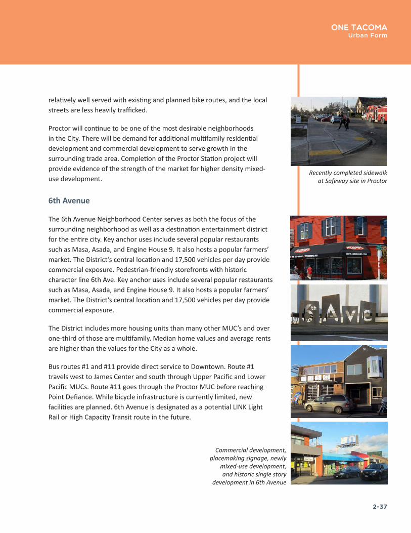
6th Avenue
The 6th Avenue Neighborhood Center serves as both the focus of the surrounding neighborhood as well as a destination entertainment district for the entire city. Key anchor uses include several popular restaurants such as Masa, Asada, and Engine House 9. It also hosts a popular farmers’ market. The District’s central location and 17,500 vehicles per day provide commercial exposure. Pedestrian-friendly storefronts with historic character line 6th Ave. Key anchor uses include several popular restaurants such as Masa, Asada, and Engine House 9. It also hosts a popular farmers’ market. The District’s central location and 17,500 vehicles per day provide commercial exposure.
The District includes more housing units than many other MUC’s and over one-third of those are multifamily. Median home values and average rents are higher than the values for the City as a whole.
Bus routes #1 and #11 provide direct service to Downtown. Route #1 travels west to James Center and south through Upper Pacific and Lower Pacific MUCs. Route #11 goes through the Proctor MUC before reaching Point Defiance. While bicycle infrastructure is currently limited, new facilities are planned. 6th Avenue is designated as a potential LINK Light Rail or High Capacity Transit route in the future.
Commercial development, placemaking signage, newly
mixed-use development, and historic single story
development in 6th Avenue
Recently completed sidewalk at Safeway site in Proctor
2-38
One Tacoma Urban Form
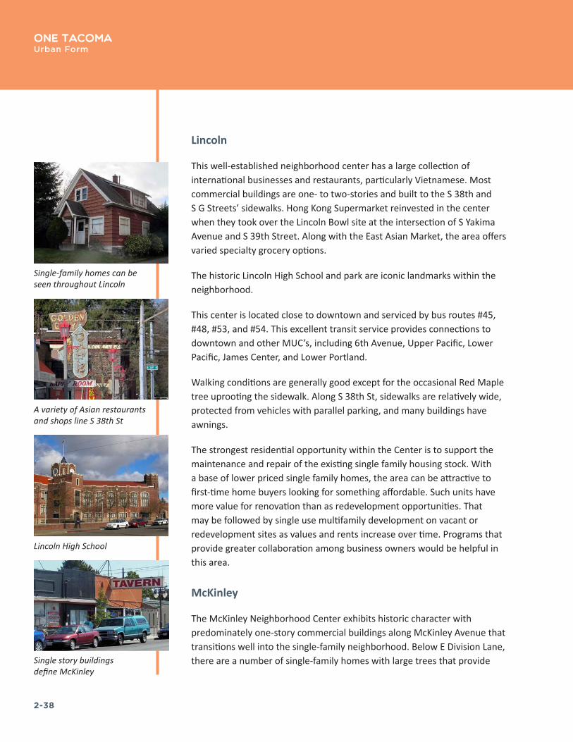
Lincoln
This well-established neighborhood center has a large collection of international businesses and restaurants, particularly Vietnamese. Most commercial buildings are one- to two-stories and built to the S 38th and S G Streets’ sidewalks. Hong Kong Supermarket reinvested in the center when they took over the Lincoln Bowl site at the intersection of S Yakima Avenue and S 39th Street. Along with the East Asian Market, the area offers varied specialty grocery options.
The historic Lincoln High School and park are iconic landmarks within the neighborhood.
This center is located close to downtown and serviced by bus routes #45, #48, #53, and #54. This excellent transit service provides connections to downtown and other MUC’s, including 6th Avenue, Upper Pacific, Lower Pacific, James Center, and Lower Portland.
Walking conditions are generally good except for the occasional Red Maple tree uprooting the sidewalk. Along S 38th St, sidewalks are relatively wide, protected from vehicles with parallel parking, and many buildings have awnings.
The strongest residential opportunity within the Center is to support the maintenance and repair of the existing single family housing stock. With a base of lower priced single family homes, the area can be attractive to first-time home buyers looking for something affordable. Such units have more value for renovation than as redevelopment opportunities. That may be followed by single use multifamily development on vacant or redevelopment sites as values and rents increase over time. Programs that provide greater collaboration among business owners would be helpful in this area.
McKinley
The McKinley Neighborhood Center exhibits historic character with predominately one-story commercial buildings along McKinley Avenue that transitions well into the single-family neighborhood. Below E Division Lane, there are a number of single-family homes with large trees that provide
Single-family homes can be seen throughout Lincoln
Single story buildings define McKinley
A variety of Asian restaurants and shops line S 38th St
Lincoln High School

2-39
One TacomaUrban Form
the residential streets a sense of enclosure. With a gymnasium, worship center, and numerous facility options, the Tacoma Christian Center is the neighborhood “heart. The Top of Tacoma Bar and Café is the commercial anchor. The bar and the church draw from a wide area within the city, but there are few businesses to support the local neighborhood. The overall amount of commercial space is small and there is vacant space.
The only open space in the center is Ray C. Roberts Park, which has a small marker, benches, and landscaping. On the north boundary, McKinley Park takes advantage of significant topography changes. The center also has parks to the east. This was recently renovated, providing residents playgrounds, views to downtown, walking trails, and a dog run. Some of the streets, sloping west and north, feature views of Commencement Bay.
The strongest asset within the neighborhood is the existing housing stock. With a base of affordable single family homes, the area can be attractive to first-time home buyers looking for something affordable.
Narrows
The Narrows Neighborhood Center consists of generally low-intensity, auto-oriented commercial uses along 6th Avenue, surrounded by single-family housing and a cluster of garden-style apartments on the western edge. Despite, these amenities, uses are disconnected and the center lacks any defining characteristics. There are almost 400 housing units in the center with two-thirds of them being multifamily. Many of the units are in the Skyview development on the north side of 6th Avenue. The median home price and rent are well below the averages for the City as a whole. However, the median household income is only slightly below the average. There are a number of community amenities, such as a library, charter school, War Memorial Park with connecting trail, Tacoma Musical Playhouse, and waterfront views.
Short blocks generally create a comfortable walking condition although auto-oriented businesses and lack of pedestrian amenities along the street are a hindrance to activating the Center. Furthermore, there is only one central crosswalk across 6th Avenue.
Single family homes along McKinley Ave
Views of the Narrows waterway
Tacoma Christian Center is the “heart” of the
McKinley neighborhood
Auto-oriented on 6th Ave

2-40
One Tacoma Urban Form
There are some vacant and underutilized sites in the area including former service station sites that could be assembled for larger developments. With increases in prevailing rents, and depreciation of existing improvements, redevelopment of these sites will become feasible over time. With further increases, the area could support true mixed use buildings. Until such time, the Narrows Center will primarily serve a more local role.
South Tacoma Way
The South Tacoma Way Neighborhood Center is well located to serve the South Tacoma market area, at the intersection of two well-traveled arterials. Retail demand in the center will continue to grow with growth in the trade area, and will support for a wider range of neighborhood serving businesses. The area should also be increasingly attractive for residential development. A Sounder Rail Station will be located south of the center, and the STAR Center is a major recreation complex located southwest of the center. The existing building stock offers the potential for affordable housing in the upper floors of existing buildings. Such space could also serve as incubator space for new businesses or studio space for artists. As the area becomes established as a desirable place to live, new apartment buildings may be supportable on vacant or underutilized properties.
The South Park Recreation Center provides large open space within the center. Other community amenities line S 56th Street, including post office, library, and weekly farmer’s market.
In addition to bus transit, the Sounder Commuter Rail stops between S 56th and 58th Streets. 220 parking spaces are available at the station.
This Center has a lot of commercial services and a significant employment base, but few residential units and limited redevelopment opportunities. The overriding focus should be on encouraging residential development.
Streetscape along S Tacoma Way
Unique art in the public realm
Historic industrial buildings

2-41
One TacomaUrban Form
Point Ruston
Point Ruston is a unique mixed-use waterfront destination that will provide both neighborhood services and draw from a city-wide customer base. The Center is positioned on the former Asarco property, between the Ruston Way waterfront recreation area and Point Defiance—an area that draws several million visitors a year. The Point Ruston development, still under construction, is the only center based on a single development site. The center will be anchored by a theater, grocery and hotel as well as providing other shopping and amenities the estimated 800–1,000 households expected to be accommodated on site. The Dome to Defiance Signature Trail provide a significant recreational amenity, linking the development to other park and cultural destinations within an easy walk or bike ride.
GOAL UF–7 Promote Neighborhood Centers as thriving centers that serve the needs of surrounding neighborhoods.
Policy UF–7.1 In Neighborhood Centers, provide for higher concentrations of development, employment, commercial and community services, and a wider range of housing options than the surrounding neighborhoods.
Policy UF–7.2 Provide for a wide range of housing types in Neighborhood Centers, which are intended to generally be larger in scale than the surrounding residential areas, but smaller than Crossroads Centers. There should be sufficient zoning within a half-mile walking distance of a Neighborhood Center to accommodate a minimum of 3,000 households.
Policy UF–7.3 Design Neighborhood Centers as multimodal transportation hubs that optimize pedestrian and bicycle access from adjacent neighborhoods and are served by frequent-service transit.
Policy UF–7.4 Provide small parks or plazas within or near Neighborhood Centers to support their roles as places of local activity and gathering.
Point Ruston ferry

2-42
One Tacoma Urban Form
EMPLOYMENT AREAS
Tacoma’s location between Portland and Seattle provides it access to many modes of transportation, natural resources, economical power sources, and a deep, sheltered harbor, all of which have contributed to Tacoma’s development as a successful industrial, commercial and trading center. The modern city has its beginnings in the mid-nineteenth century, when it was designated as Northern Pacific Railroad’s western terminus for its transcontinental railroad in 1873.
Tacoma continues its tradition as a West Coast hub for trade, with the Port of Tacoma among the most important in the nation and the Pacific Rim. Regional shopping centers such as the Tacoma Mall have emerged to provide goods and services for the city and the region, while the emphasis in downtown has changed to professional offices, international finance, government, education, and cultural facilities.
The city’s employment geographies are:
Downtown Tacoma
Downtown Tacoma has emerged as the economic engine for the City of Tacoma, Pierce County and the South Sound region. This cluster of economic activity with nearly 45,000 jobs includes financial services, health services, and professional services.
Manufacturing + Industrial Areas
Manufacturing/Industrial areas are in the low, flat areas along the Port/Tideflats and the Nalley Valley. The manufacturing and distribution sectors concentrate here. Manufacturing/industrial centers are intended to be well-served by major transportation facilities including rail, interstate and transit systems. Many of the industrial uses are land intensive in nature. To preserve land at these centers, large retail, residential or nonrelated office uses are discouraged.
Navy tugboat being lifted onto a heavy-lift vessel at the Port of Tacoma
Tacoma Financial Center in the Downtown Core
2-43
One TacomaUrban Form
Commercial Districts
Commercial development involves a wide variety of uses and can range in scale from small neighborhood convenience shops to regional shopping centers. Commercial areas are the activity centers of the community. Commercial districts should be safe, well designed, appropriately scaled, and integrated into the fabric of the community. Infill development and intensification of existing commercial areas will aid their continued economic viability. In some limited instances, physical expansion of existing areas may be permitted; however, linear expansion is to be strictly limited. Commercial development within the mixed-use centers is also guided by policies in Section II specifically addressing the designated centers.
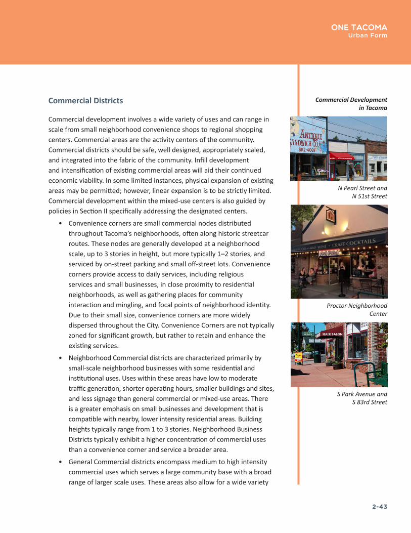
• Convenience corners are small commercial nodes distributed throughout Tacoma’s neighborhoods, often along historic streetcar routes. These nodes are generally developed at a neighborhood scale, up to 3 stories in height, but more typically 1–2 stories, and serviced by on-street parking and small off-street lots. Convenience corners provide access to daily services, including religious services and small businesses, in close proximity to residential neighborhoods, as well as gathering places for community interaction and mingling, and focal points of neighborhood identity. Due to their small size, convenience corners are more widely dispersed throughout the City. Convenience Corners are not typically zoned for significant growth, but rather to retain and enhance the existing services.
• Neighborhood Commercial districts are characterized primarily by small-scale neighborhood businesses with some residential and institutional uses. Uses within these areas have low to moderate traffic generation, shorter operating hours, smaller buildings and sites, and less signage than general commercial or mixed-use areas. There is a greater emphasis on small businesses and development that is compatible with nearby, lower intensity residential areas. Building heights typically range from 1 to 3 stories. Neighborhood Business Districts typically exhibit a higher concentration of commercial uses than a convenience corner and service a broader area.
• General Commercial districts encompass medium to high intensity commercial uses which serves a large community base with a broad range of larger scale uses. These areas also allow for a wide variety
N Pearl Street and N 51st Street
Proctor Neighborhood Center
Commercial Development in Tacoma
S Park Avenue and S 83rd Street
2-44
One Tacoma Urban Form
of residential development, community facilities, institutional uses, and some limited production and storage uses. These areas are generally located along major transportation corridors, often with reasonably direct access to a highway. This designation is characterized by larger-scale buildings, longer operating hours, and moderate to high traffic generation.
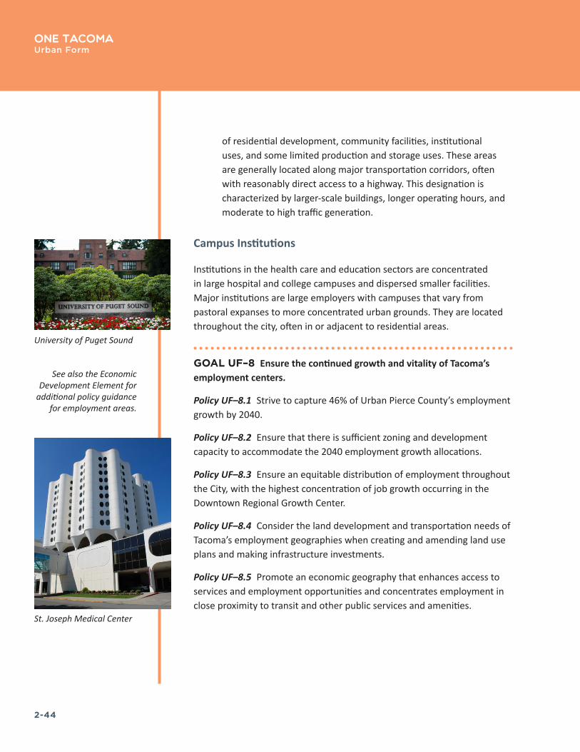
Campus Institutions
Institutions in the health care and education sectors are concentrated in large hospital and college campuses and dispersed smaller facilities. Major institutions are large employers with campuses that vary from pastoral expanses to more concentrated urban grounds. They are located throughout the city, often in or adjacent to residential areas.
GOAL UF–8 Ensure the continued growth and vitality of Tacoma’s employment centers.
Policy UF–8.1 Strive to capture 46% of Urban Pierce County’s employment growth by 2040.
Policy UF–8.2 Ensure that there is sufficient zoning and development capacity to accommodate the 2040 employment growth allocations.
Policy UF–8.3 Ensure an equitable distribution of employment throughout the City, with the highest concentration of job growth occurring in the Downtown Regional Growth Center.
Policy UF–8.4 Consider the land development and transportation needs of Tacoma’s employment geographies when creating and amending land use plans and making infrastructure investments.
Policy UF–8.5 Promote an economic geography that enhances access to services and employment opportunities and concentrates employment in close proximity to transit and other public services and amenities.
See also the Economic Development Element for
additional policy guidance for employment areas�
St. Joseph Medical Center
University of Puget Sound

2-45
One TacomaUrban Form
TRANSIT STATION AREAS
Transit stations provide access to high-capacity and high-frequency transit, which currently consist of light rail and commuter rail but in the future may also include bus rapid transit and Regional Light Rail (see Figure 6, Transit Network, on the following page). These policies encourage housing and employment growth in transit station areas to maximize the ability of people to benefit from the regional connections they provide and to increase transit access to employment. The policies support a range of transit station area types, with differing priorities for growth, depending on the station type and context. Priority is given to growth in station areas located in centers since they provide more people with opportunities to be close to both transit and to commercial and public services. These stations have the highest potential for mixed-use development. Center stations benefit from the concentration of local services and businesses as well as connections to other transit routes typically found on corridors.
Tacoma Dome station
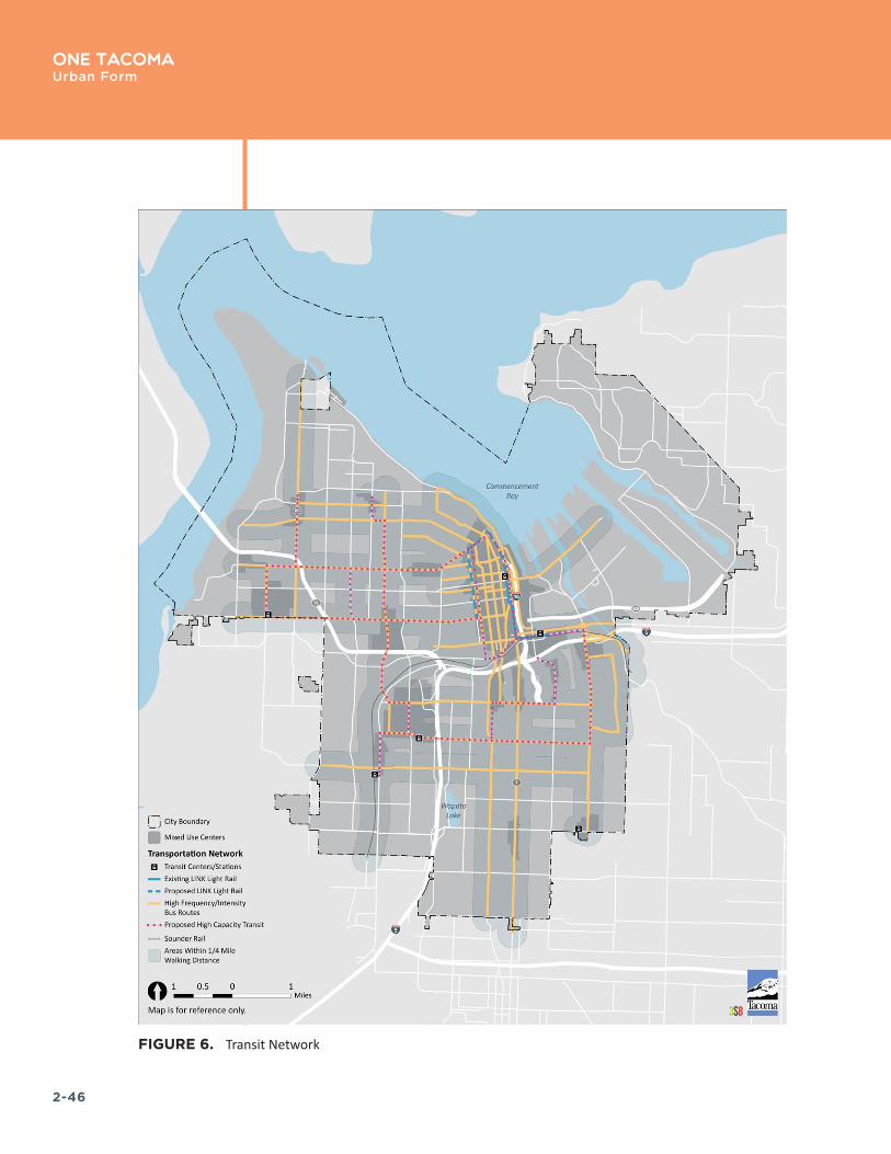
2-46
One Tacoma Urban Form
FIGURE 6. Transit Network

2-47
One TacomaUrban Form
GOAL UF–9 Promote future residential and employment growth in coordination with transit infrastructure and service investments.
Policy UF–9.1 Encourage transit-oriented development and transit-supportive concentrations of jobs and housing, and multimodal connections, at and adjacent to high-frequency and high-capacity transit stations.
Policy UF–9.2 Integrate transit stations into surrounding communities and enhance pedestrian and bicycle connections to provide safe access to key destinations beyond the station area.
Policy UF–9.3 Design transit areas to improve pedestrian, bicycle, and personal safety within the station and the station area.
Policy UF–9.4 Encourage transit stations in centers to provide high density concentrations of housing and commercial uses that maximize the ability of residents to live close to both high-quality transit and commercial services.
Policy UF–9.5 Encourage concentrations of jobs and employment-focused land uses in and around stations in employment areas.
Policy UF–9.6 Enhance connections between major destinations and transit facilities and strengthen the role of these stations as places of focused activity.
Policy UF–9.7 Encourage concentrations of mixed-income residential development and supportive commercial services close to high capacity transit stations that are not located in a center.

2-48
One Tacoma Urban Form
CORRIDORS
Corridors, like centers, are areas where Tacoma will grow and change over the next 25 years. They are busy, active streets with redevelopment potential. They are close to neighborhoods and are places with transit, stores, housing and employers. They need to be planned, designed and improved to be places that benefit and become successful additions to surrounding neighborhoods. The largest places of focused activity and density along these corridors are designated as centers. Corridors are not intended to be long commercial strips or a single land use pattern, but to achieve a range of land use types and densities that vary along the corridor (see Figure 7, Corridors).
Where Chapter 7: the Transportation Master Plan establishes a transportation hierarchy for the system as well as for individual corridors, the following policies direct the design of corridors to consider the direct integration of land use and transportation and the role of public rights-of-way in creating interesting, vibrant and unique places. Along the corridors, the designated mixed-use centers should have the highest degree of design quality and amenities for pedestrians, residents, and retail use.
GOAL UF–10 Establish designated corridors as thriving places that support and connect Tacoma’s centers.
Policy UF–10.1 Enhance the design and transportation function of Centers, Corridors, Transit Station Areas, and Signature Trails.
Policy UF–10.2 Evaluate adjacent land uses to help inform street classifications in framing, shaping and activating the public space of streets.
Policy UF–10.3 Integrate both the placemaking and transportation functions when designing and managing streets by encouraging design, development, and operation of streets to enhance opportunities for them to serve as places for community interaction, environmental function, open space, recreation, and other community purposes.
Policy UF–10.4 Encourage the design and alignment of corridors to respond to topography and natural features, and to maintain public views of prominent landmarks and buildings that serve as visual focal points within streets or that terminate at the end of streets.
TYPES OF DESIGNATED CORRIDORS:
AvenueMain Street
Transit PriorityUrban Residential
Freight CorridorBicycle Boulevard
GREAT STREETS:
The American Planning Association celebrates
places of exemplary character, quality, and
planning� Places are selected annually and
represent the gold standard in terms of having a true sense
of place, cultural and historical interest,
community involvement, and a vision for tomorrow�
Great Streets are selected based on street
form and composition, character and personality
and environment and sustainability�
More information can be found at this link:
https://www.planning.org/greatplaces/streets/
characteristics.htm�
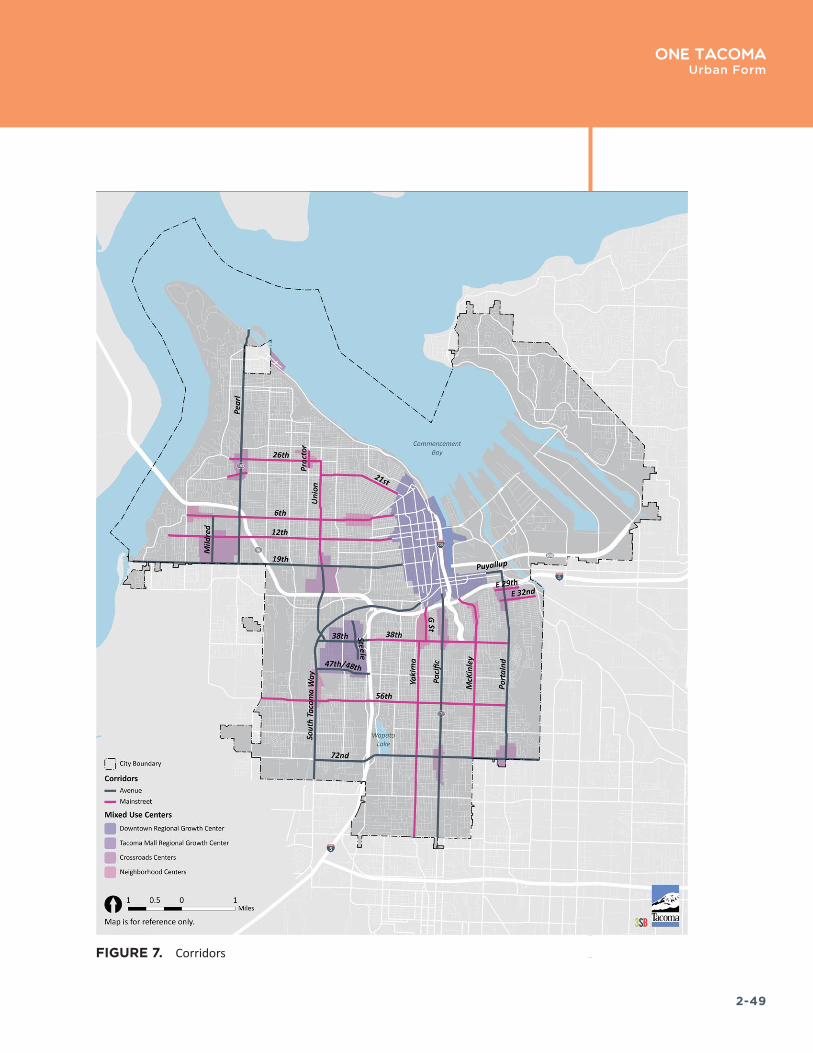
2-49
One TacomaUrban Form
FIGURE 7. Corridors
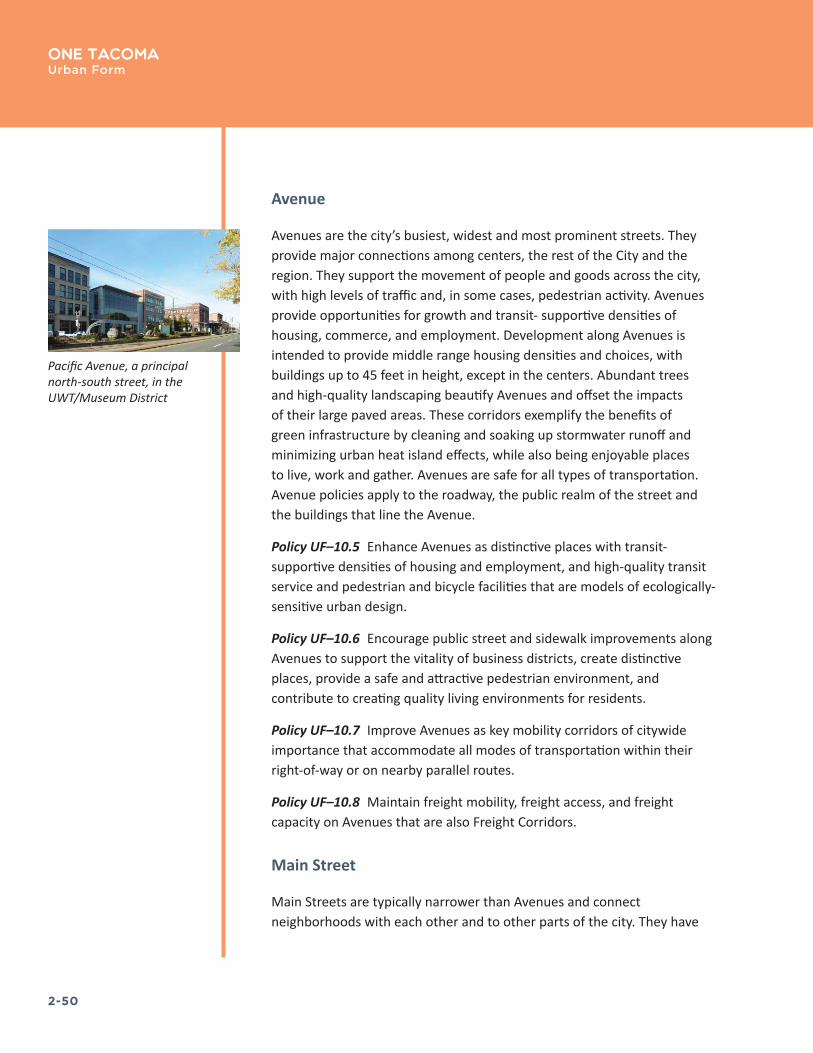
2-50
One Tacoma Urban Form
Avenue
Avenues are the city’s busiest, widest and most prominent streets. They provide major connections among centers, the rest of the City and the region. They support the movement of people and goods across the city, with high levels of traffic and, in some cases, pedestrian activity. Avenues provide opportunities for growth and transit- supportive densities of housing, commerce, and employment. Development along Avenues is intended to provide middle range housing densities and choices, with buildings up to 45 feet in height, except in the centers. Abundant trees and high-quality landscaping beautify Avenues and offset the impacts of their large paved areas. These corridors exemplify the benefits of green infrastructure by cleaning and soaking up stormwater runoff and minimizing urban heat island effects, while also being enjoyable places to live, work and gather. Avenues are safe for all types of transportation. Avenue policies apply to the roadway, the public realm of the street and the buildings that line the Avenue.
Policy UF–10.5 Enhance Avenues as distinctive places with transit-supportive densities of housing and employment, and high-quality transit service and pedestrian and bicycle facilities that are models of ecologically-sensitive urban design.
Policy UF–10.6 Encourage public street and sidewalk improvements along Avenues to support the vitality of business districts, create distinctive places, provide a safe and attractive pedestrian environment, and contribute to creating quality living environments for residents.
Policy UF–10.7 Improve Avenues as key mobility corridors of citywide importance that accommodate all modes of transportation within their right-of-way or on nearby parallel routes.
Policy UF–10.8 Maintain freight mobility, freight access, and freight capacity on Avenues that are also Freight Corridors.
Main Street
Main Streets are typically narrower than Avenues and connect neighborhoods with each other and to other parts of the city. They have
Pacific Avenue, a principal north-south street, in the UWT/Museum District

2-51
One TacomaUrban Form
transportation, land use and design functions that are important at a neighborhood or district level. They support neighborhood business districts and provide housing opportunities close to local services, amenities and transit lines. They are streets that include a mix of commercial and multi-family housing development.
This policy is intended to balance the important transportation functions of Main Streets with their roles in supporting the viability of business districts and residential livability.
Policy UF–10.9 Enhance Main Streets as important places that support vibrant neighborhood business districts with quality multi-family housing while providing transportation connections that link neighborhoods and public amenities.
Policy UF–10.10 Design Main Streets to support active retail storefronts, versatile use of public spaces for amenities and events, and to support concentrated pedestrian activity.
Transit Priority
Transit priority streets currently have or are planned to have frequent bus service, street-car routes, or other form of high occupancy transit. These streets generally require design accommodations specific to the needs of transit. Policies related to transit priority corridors are provided in Chapter 7: the Transportation Master Plan.
McKinley Avenue at E 35th St
Distinctive ighting on S 38th Street in the Lincoln
International District
Puyallup Avenue

2-52
One Tacoma Urban Form
Urban Residential
Urban residential streets are appropriate in areas predominantly characterized by existing or planned dense residential development, especially within and around designated mixed-use centers.
Policy UF–10.11 Support an enhanced pedestrian environment, including wider sidewalks, vegetation, seating, public art.
Policy UF–10.12 Support opportunities for low impact development techniques.
Policy UF–10.13 Provide extra on-street parking for visitors of residents and customers of nearby businesses.
Policy UF–10.14 Safely accommodate bicycles and non-motorized transportation.
Policy UF–10.15 Explore innovative concepts for developing shared space or “woonerfs” for low speed vehicles, bicycles, and pedestrians.
Freight Corridor
Freight Corridors are the primary routes into and through the city that supports Tacoma as an important West Coast hub and a gateway for international and domestic trade. While the forms of these streets are not expected to change significantly, they are integral to the growth of traded sector businesses such as manufacturing, warehousing and distribution industries. Policies related to freight are provided in Chapter 7: the Transportation Master Plan and Chapter 6: Economic Development.
Policy UF–10.16 Develop, manage and maintain a safe, efficient and reliable freight street network to provide freight access to and from intermodal freight facilities, industrial and commercial districts and the regional transportation system.
Policy UF–10.17 Invest to accommodate forecasted growth of interregional freight volumes and provide access to truck, marine, rail, and air transportation systems.
Pedestrian crossing near a school
Rail near Titlow Park
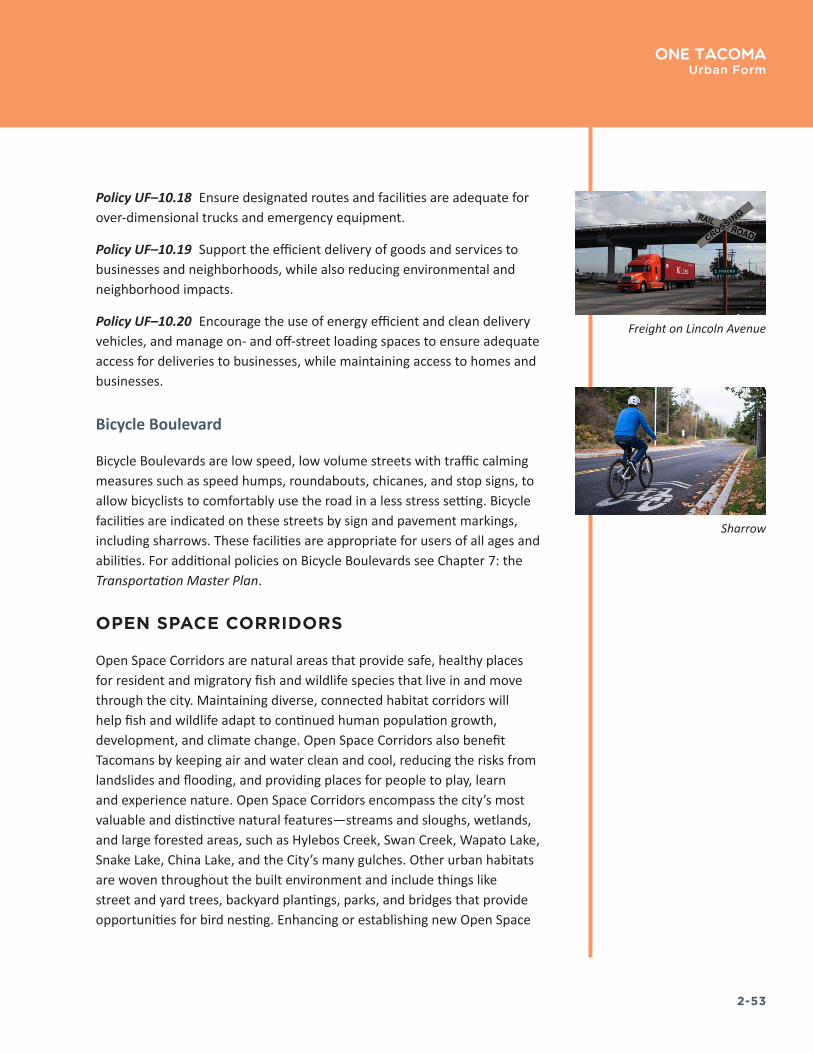
2-53
One TacomaUrban Form
Policy UF–10.18 Ensure designated routes and facilities are adequate for over-dimensional trucks and emergency equipment.
Policy UF–10.19 Support the efficient delivery of goods and services to businesses and neighborhoods, while also reducing environmental and neighborhood impacts.
Policy UF–10.20 Encourage the use of energy efficient and clean delivery vehicles, and manage on- and off-street loading spaces to ensure adequate access for deliveries to businesses, while maintaining access to homes and businesses.
Bicycle Boulevard
Bicycle Boulevards are low speed, low volume streets with traffic calming measures such as speed humps, roundabouts, chicanes, and stop signs, to allow bicyclists to comfortably use the road in a less stress setting. Bicycle facilities are indicated on these streets by sign and pavement markings, including sharrows. These facilities are appropriate for users of all ages and abilities. For additional policies on Bicycle Boulevards see Chapter 7: the Transportation Master Plan.
OPEN SPACE CORRIDORS
Open Space Corridors are natural areas that provide safe, healthy places for resident and migratory fish and wildlife species that live in and move through the city. Maintaining diverse, connected habitat corridors will help fish and wildlife adapt to continued human population growth, development, and climate change. Open Space Corridors also benefit Tacomans by keeping air and water clean and cool, reducing the risks from landslides and flooding, and providing places for people to play, learn and experience nature. Open Space Corridors encompass the city’s most valuable and distinctive natural features—streams and sloughs, wetlands, and large forested areas, such as Hylebos Creek, Swan Creek, Wapato Lake, Snake Lake, China Lake, and the City’s many gulches. Other urban habitats are woven throughout the built environment and include things like street and yard trees, backyard plantings, parks, and bridges that provide opportunities for bird nesting. Enhancing or establishing new Open Space
Freight on Lincoln Avenue
Sharrow

2-54
One Tacoma Urban Form
Corridors will involve preserving and restoring existing natural features, creating vegetated connections between tree canopy and greenspaces, and incorporating nature into the design of buildings and landscaping, streetscapes, parking lots, and infrastructure.
GOAL UF–11 Preserve and protect open space corridors to ensure a healthy and sustainable environment and to provide opportunities for Tacomans to experience nature close to home.
Policy UF–11.1 Create an integrated system of Open Space Corridors that defines and enhances the built and natural environment, offers a well-balanced range of experiences, and enriches the lives of Tacoma’s current and future citizens.
Policy UF–11.2 Improve Open Space Corridors using a mix of tools including natural resource protection, property acquisition, natural resource restoration, tree planting and landscaping with native plants, and ecological design integrated with new development.
Policy UF–11.3 Ensure that connections between Open Space Corridors, streets and trail systems are located and designed to support the functions of each element, and create positive interrelationships between the elements, while also protecting habitat functions, fish, and wildlife.
Bridge over forested area in Wapato Lake Park
See also the Environment + Watershed Health Element and Parks + Recreation Element
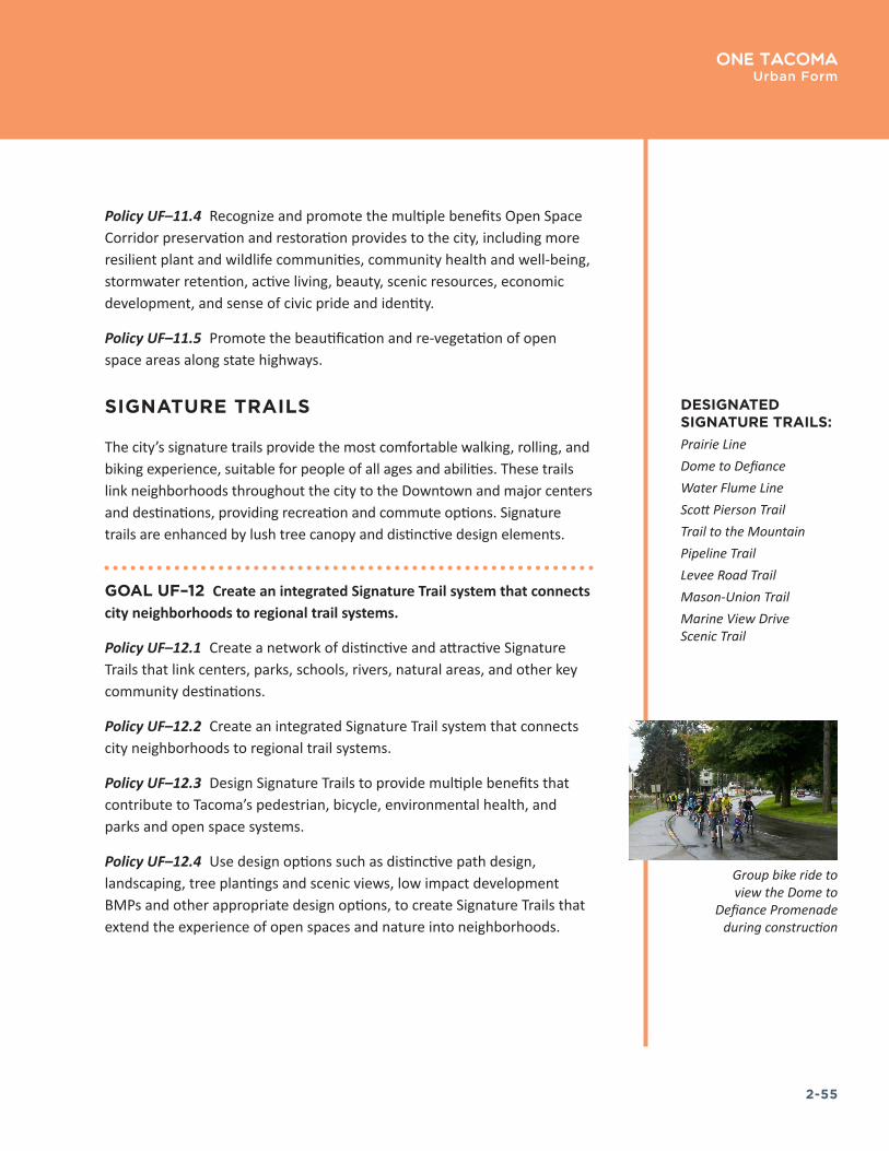
2-55
One TacomaUrban Form
Policy UF–11.4 Recognize and promote the multiple benefits Open Space Corridor preservation and restoration provides to the city, including more resilient plant and wildlife communities, community health and well-being, stormwater retention, active living, beauty, scenic resources, economic development, and sense of civic pride and identity.
Policy UF–11.5 Promote the beautification and re-vegetation of open space areas along state highways.
SIGNATURE TRAILS
The city’s signature trails provide the most comfortable walking, rolling, and biking experience, suitable for people of all ages and abilities. These trails link neighborhoods throughout the city to the Downtown and major centers and destinations, providing recreation and commute options. Signature trails are enhanced by lush tree canopy and distinctive design elements.
GOAL UF–12 Create an integrated Signature Trail system that connects city neighborhoods to regional trail systems.
Policy UF–12.1 Create a network of distinctive and attractive Signature Trails that link centers, parks, schools, rivers, natural areas, and other key community destinations.
Policy UF–12.2 Create an integrated Signature Trail system that connects city neighborhoods to regional trail systems.
Policy UF–12.3 Design Signature Trails to provide multiple benefits that contribute to Tacoma’s pedestrian, bicycle, environmental health, and parks and open space systems.
Policy UF–12.4 Use design options such as distinctive path design, landscaping, tree plantings and scenic views, low impact development BMPs and other appropriate design options, to create Signature Trails that extend the experience of open spaces and nature into neighborhoods.
DESIGNATED SIGNATURE TRAILS:Prairie LineDome to DefianceWater Flume LineScott Pierson TrailTrail to the MountainPipeline TrailLevee Road TrailMason-Union TrailMarine View Drive Scenic Trail
Group bike ride to view the Dome to
Defiance Promenade during construction

2-56
One TacomaUrban Form
HISTORIC RESIDENTIAL PATTERN AREAS
Tacoma has six distinct Historic Residential Pattern Areas, as shown in Figure 8. The development patterns and characteristics of these areas are influenced by the natural landscape and how and when these parts of the city were developed. Each Historic Residential Pattern Area has unique physical, social, cultural and environmental qualities that differentiate them and create their sense of place. In order to maintain and enhance the positive qualities and sense of place in each pattern area, it is desirable to have policies and regulations that respond to each area’s unique natural and built assets. The following policies identify key characteristics of each of Tacoma’s Historic Residential Areas that are relevant to decisions related to future development in these areas as well as special opportunities to enhance the residential environment. For additional information about these areas, see Appendix 2, Residential Pattern Areas.
GOAL UF–13 Promote the unique physical, social and cultural character Historic Residential Pattern Areas as integral to Tacoma’s sense of place.
Policy UF–13.1 Plan investments in residential pattern areas to better integrate the area with the designated mixed-use centers and other commercial areas and amenities.
Policy UF–13.2 Promote infill development within the residential pattern areas that respects the context of the area and contributes to the overall quality of design.
Policy UF–13.3 Utilize the findings of the TacHOMEa Infill Report in developing future design guidelines and/or development standards that apply within the following residential pattern areas.
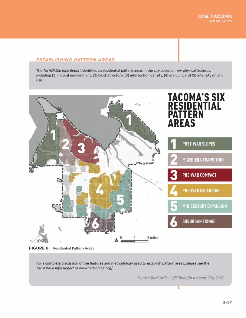
2-57
One TacomaUrban Form
The TacHOMEa Infill Report identifies six residential pattern areas in the city based on key physical features, including (1) natural environment, (2) block structure, (3) intersection density, (4) era built, and (5) intensity of land use.
For a complete discussion of the features and methodology used to establish pattern areas, please see the TacHOMEa Infill Report at www.tachomea.org/.
Source: TacHOMEa: Infill Tools for a Happy City, 2015.
ESTABLISHING PATTERN AREAS
FIGURE 8. Residential Pattern Areas

2-58
One TacomaUrban Form
Pattern Area 1: Post-War Slopes
These areas were primarily developed during the post-war period and is characterized by the prevalence of garages, curvilinear streets, and cul-de-sac development. The disrupted street grid limits route directness but lends itself to a sense of privacy and security within neighborhoods. Houses tend to be ranch, double-ranch, or more contemporary building styles, often with garages more prominently situated at the front of the structure and facing the street, as alleys are rare. Many homes have long frontages and are typically 1–1.5 stories as the area includes view overlays.
Policy UF–13.4 New development should be oriented to take advantage of the view of Commencement Bay and the Tacoma Narrows and to preserve significant public views.
Policy UF–13.5 Preserve and restore the slopes and gulches for their aesthetic qualities, to provide wildlife habitat, and to expand passive recreational opportunities.
Policy UF–13.6 Pursue funding to acquire open space properties and require easements as necessary to complete the West Slope and Northeast Tacoma trail systems consistent with Shoreline Public Access Plan and Transportation Master Plan.
Policy UF–13.7 Complete pedestrian facilities and enhance bicyclist and pedestrian safety along Marine View Drive to improve opportunities to enjoy the waterfront and to learn about ongoing restoration efforts.
Policy UF–13.8 Improve neighborhood bicycle and pedestrian access to the waterfront, especially to Narrows Marina, Titlow Park, Marine View Drive and Point Defiance.
Policy UF–13.9 Improve the streetscapes along 6th Avenue and Pearl to support infill redevelopment opportunities and to create vibrant and distinctive public places.
Policy UF–13.10 Maintain and enhance the existing commercial areas while preserving the unique features of these neighborhoods.
QUALITIES:
TopographySloped
Block StructureCurvilinear
Intersection DensityDisconnected
Era of DevelopmentPost-war
Land UseLow Intensity
Source: TacHOMEa: Infill Tools for a Happy City, 2015�
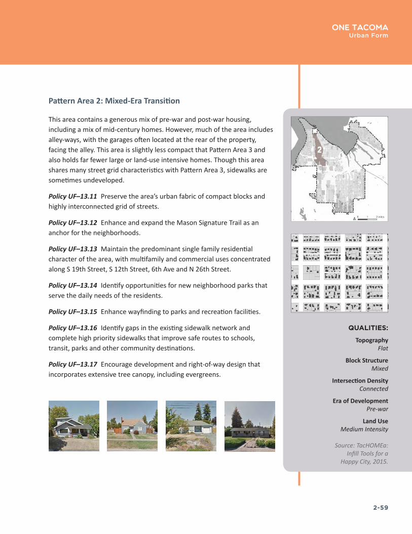
2-59
One TacomaUrban Form
Pattern Area 2: Mixed-Era Transition
This area contains a generous mix of pre-war and post-war housing, including a mix of mid-century homes. However, much of the area includes alley-ways, with the garages often located at the rear of the property, facing the alley. This area is slightly less compact that Pattern Area 3 and also holds far fewer large or land-use intensive homes. Though this area shares many street grid characteristics with Pattern Area 3, sidewalks are sometimes undeveloped.
Policy UF–13.11 Preserve the area’s urban fabric of compact blocks and highly interconnected grid of streets.
Policy UF–13.12 Enhance and expand the Mason Signature Trail as an anchor for the neighborhoods.
Policy UF–13.13 Maintain the predominant single family residential character of the area, with multifamily and commercial uses concentrated along S 19th Street, S 12th Street, 6th Ave and N 26th Street.
Policy UF–13.14 Identify opportunities for new neighborhood parks that serve the daily needs of the residents.
Policy UF–13.15 Enhance wayfinding to parks and recreation facilities.
Policy UF–13.16 Identify gaps in the existing sidewalk network and complete high priority sidewalks that improve safe routes to schools, transit, parks and other community destinations.
Policy UF–13.17 Encourage development and right-of-way design that incorporates extensive tree canopy, including evergreens.
QUALITIES:
TopographyFlat
Block StructureMixed
Intersection DensityConnected
Era of DevelopmentPre-war
Land UseMedium Intensity
Source: TacHOMEa: Infill Tools for a
Happy City, 2015�

2-60
One TacomaUrban Form
Pattern Area 3: Pre-War Compact
This is Tacoma’s most historic section of residential development, and also some of the densest neighborhoods in Tacoma, containing homes ranging from pre-1900 to the current era. The street grid is very well connected and blocks tend to be fairly short, supporting a highly walkable environment. This area has a variety of pre-zoning non-conforming lot sizes, prevalent alleyways, many large historic homes, and a mix of residential types and non-residential uses blended within the historic fabric. A significant portion of this area is built on dramatic slopes with home designs emphasizing views of Commencement Bay and Puget Sound.
Policy UF–13.18 Maintain and enhance the streetcar era pattern of street-oriented buildings.
Policy UF–13.19 Preserve the area’s urban fabric of compact blocks and highly interconnected grid of streets.
Policy UF–13.20 Fill gaps in the urban fabric through infill development on vacant and underutilized sites.
Policy UF–13.21 Integrate new development into the districts’ historic development patterns.
Policy UF–13.22 Continue the pattern of small, connected blocks and the regular lot patterns.
Policy UF–13.23 Maintain and enhance the quality and character of the business districts, with good street frontages and pedestrian amenities.
Policy UF–13.24 Promote the retention of the existing tree canopy. Retain large, mature trees, except when they block views or pose a hazard.
Policy UF–13.25 Use the extensive street, sidewalk, and trail system to make connections to Downtown Tacoma and other major destinations. Enhance the gulches along Ruston Way to provide a respite from the built environment and to promote connectivity between the neighborhoods and the shoreline.
QUALITIES:
TopographySloped
Block StructureStraight
Intersection DensityConnected
Era of DevelopmentPre-war
Land UseHigh Intensity
Source: TacHOMEa: Infill Tools for a Happy City, 2015�
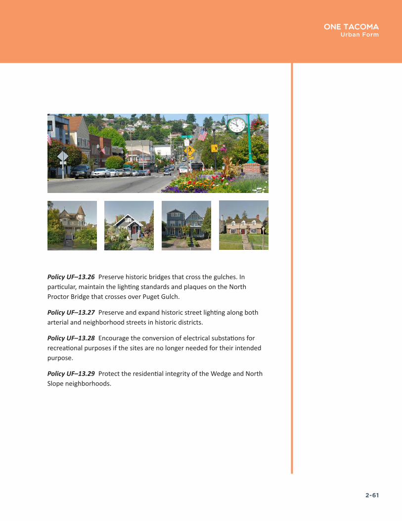
2-61
One TacomaUrban Form
Policy UF–13.26 Preserve historic bridges that cross the gulches. In particular, maintain the lighting standards and plaques on the North Proctor Bridge that crosses over Puget Gulch.
Policy UF–13.27 Preserve and expand historic street lighting along both arterial and neighborhood streets in historic districts.
Policy UF–13.28 Encourage the conversion of electrical substations for recreational purposes if the sites are no longer needed for their intended purpose.
Policy UF–13.29 Protect the residential integrity of the Wedge and North Slope neighborhoods.
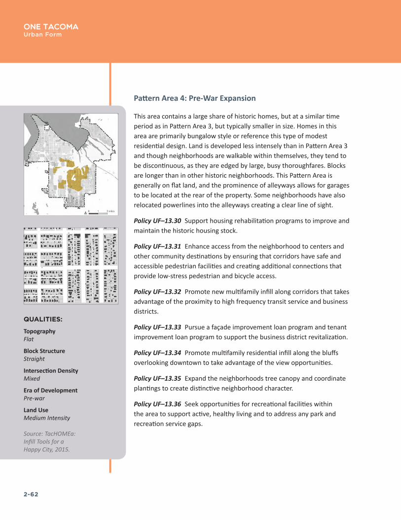
2-62
One TacomaUrban Form
Pattern Area 4: Pre-War Expansion
This area contains a large share of historic homes, but at a similar time period as in Pattern Area 3, but typically smaller in size. Homes in this area are primarily bungalow style or reference this type of modest residential design. Land is developed less intensely than in Pattern Area 3 and though neighborhoods are walkable within themselves, they tend to be discontinuous, as they are edged by large, busy thoroughfares. Blocks are longer than in other historic neighborhoods. This Pattern Area is generally on flat land, and the prominence of alleyways allows for garages to be located at the rear of the property. Some neighborhoods have also relocated powerlines into the alleyways creating a clear line of sight.
Policy UF–13.30 Support housing rehabilitation programs to improve and maintain the historic housing stock.
Policy UF–13.31 Enhance access from the neighborhood to centers and other community destinations by ensuring that corridors have safe and accessible pedestrian facilities and creating additional connections that provide low-stress pedestrian and bicycle access.
Policy UF–13.32 Promote new multifamily infill along corridors that takes advantage of the proximity to high frequency transit service and business districts.
Policy UF–13.33 Pursue a façade improvement loan program and tenant improvement loan program to support the business district revitalization.
Policy UF–13.34 Promote multifamily residential infill along the bluffs overlooking downtown to take advantage of the view opportunities.
Policy UF–13.35 Expand the neighborhoods tree canopy and coordinate plantings to create distinctive neighborhood character.
Policy UF–13.36 Seek opportunities for recreational facilities within the area to support active, healthy living and to address any park and recreation service gaps.
QUALITIES:
TopographyFlat
Block StructureStraight
Intersection DensityMixed
Era of DevelopmentPre-war
Land UseMedium Intensity
Source: TacHOMEa: Infill Tools for a Happy City, 2015�
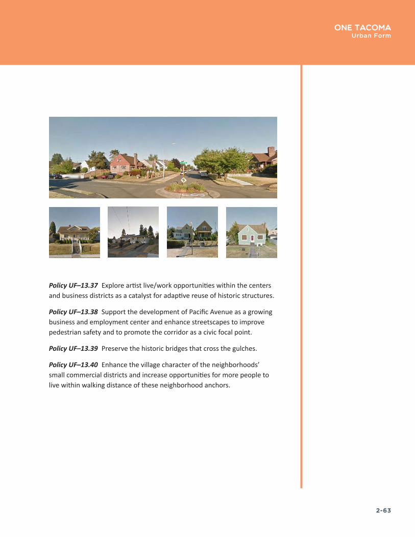
2-63
One TacomaUrban Form
Policy UF–13.37 Explore artist live/work opportunities within the centers and business districts as a catalyst for adaptive reuse of historic structures.
Policy UF–13.38 Support the development of Pacific Avenue as a growing business and employment center and enhance streetscapes to improve pedestrian safety and to promote the corridor as a civic focal point.
Policy UF–13.39 Preserve the historic bridges that cross the gulches.
Policy UF–13.40 Enhance the village character of the neighborhoods’ small commercial districts and increase opportunities for more people to live within walking distance of these neighborhood anchors.

2-64
One TacomaUrban Form
Pattern Area 5: Mid-century Expansion
This are contains a general mix of residential styles, though mid-century homes are fairly common. These post-war homes frequently emphasize garages, and though alleyways exist throughout, though to a lesser extent, they are used less than in other areas. The street grid begins to shift in this area, and blocks become longer, limiting more walkable route directness.
Policy UF–13.41 Guide the evolving street and block system in Pattern Area 5 in ways that build on positive aspects of the area’s large blocks, such as opportunities to establish mid-block open space patterns and create new connections through blocks that make it easier to access community destinations.
Policy UF–13.42 Preserve, enhance, and connect the area’s network of habitat areas and corridors, streams, parks, and tree canopy.
Policy UF–13.43 Enhance the areas distinctive system of trails to expand mobility, access to nature, and active living opportunities in the area.
Policy UF–13.44 Promote Wapato Lake as a City-wide recreation destination and provide safe and accessible bicycle and pedestrian access from residential neighborhoods and commercial areas adjacent to the Park.
Policy UF–13.45 Seek opportunities to expand access to smaller neighborhood parks and/or community gardens to create smaller neighborhood gathering places and focal points.
Policy UF–13.46 Enhance wayfinding for the Signature Trails to encourage use of the trails as comfortable walking and biking options.
Policy UF–13.47 Preserve, enhance, and connect the area’s network of habitat areas and corridors, streams, parks, and tree canopy.
Policy UF–13.48 Enhance the village character of the neighborhoods’ small commercial districts and increase opportunities for more people to live within walking distance of these neighborhood anchors.
QUALITIES:
TopographyMixed
Block StructureStraight
Intersection DensityMixed
Era of DevelopmentPost-war
Land UseLow Intensity
Source: TacHOMEa: Infill Tools for a Happy City, 2015�
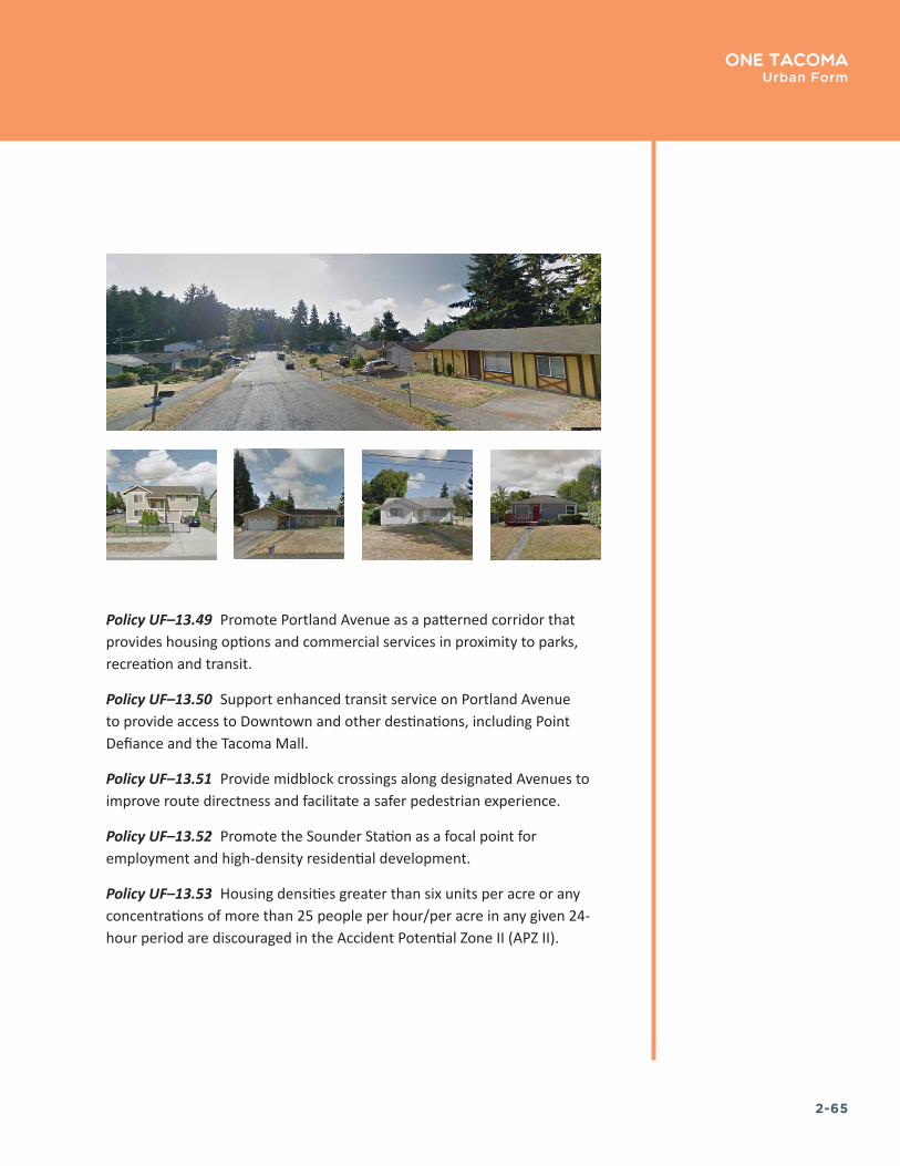
2-65
One TacomaUrban Form
Policy UF–13.49 Promote Portland Avenue as a patterned corridor that provides housing options and commercial services in proximity to parks, recreation and transit.
Policy UF–13.50 Support enhanced transit service on Portland Avenue to provide access to Downtown and other destinations, including Point Defiance and the Tacoma Mall.
Policy UF–13.51 Provide midblock crossings along designated Avenues to improve route directness and facilitate a safer pedestrian experience.
Policy UF–13.52 Promote the Sounder Station as a focal point for employment and high-density residential development.
Policy UF–13.53 Housing densities greater than six units per acre or any concentrations of more than 25 people per hour/per acre in any given 24-hour period are discouraged in the Accident Potential Zone II (APZ II).

2-66
One TacomaUrban Form
Pattern Area 6: Suburban Fringe
This area is comprised of a fairly disrupted street grid. In some cases, blocks are 3-4 times the size of blocks in compact, historic areas. While there are some historic homes interspersed in this area, much of the development is post-war. Some residents benefit from large, nearly rural lots. Some blocks have been developed as Planned Residential Developments, with new, similar-styled, but closely developed homes. This area has some flag lot and pipe stem development to make use of space within extremely deep blocks. This area tends to be fairly auto-oriented due to its less-connected streets.
Policy UF–13.54 Street, block and lot pattern: further street vacations should be limited until such time as the City can review and determine which undeveloped rights of way must be maintained and improved to promote enhanced walkability and route directness.
Policy UF–13.55 Strive to complete a 300 by 600 foot grid block length.
Policy UF–13.56 Expand access to open spaces for passive recreation and for stewardship of the areas wetlands and open space corridors.
Policy UF–13.57 Seek opportunities to create new public gathering sites and or recreation facilities.
Policy UF–13.58 Promote the revitalization of the Fern Hill Business District and the intensification of uses along Pacific Avenue to diversify the services and amenities available to the neighborhoods.
Policy UF–13.59 Encourage the use of planned residential developments as a means to completing the grid system and providing greater connectivity and route directness.
Policy UF–13.60 Promote cottage housing and planned residential development as a strategy to accommodate new residential infill while protecting and preserving the areas significant wetlands, open space and tree canopy.
Policy UF–13.61 Encourage development and right-of-way design that preserves and incorporates extensive tree canopy, including evergreens, to maintain a strong sense of nature and privacy.
QUALITIES:
TopographyFlat
Block StructureStraight
Intersection DensityDisconnected
Era of DevelopmentPost-war
Land UseLow Intensity
Source: TacHOMEa: Infill Tools for a Happy City, 2015�