Embed Size (px)
Citation preview
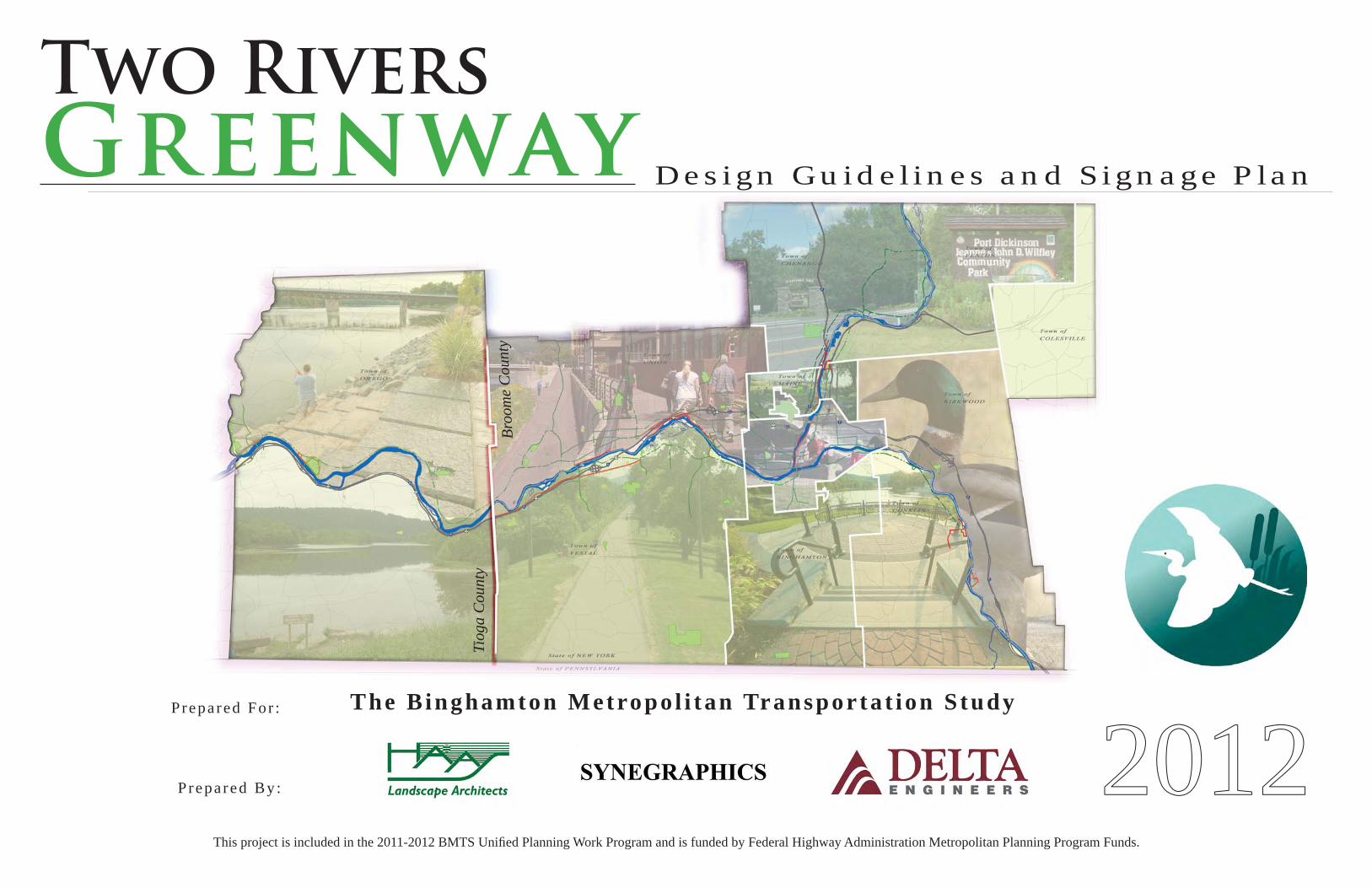
Two Rivers
Greenway
This project is included in the 2011-2012 BMTS Unifi ed Planning Work Program and is funded by Federal Highway Administration Metropolitan Planning Program Funds.
Design Guidel ines and Signage Plan
Prepa red For : The Binghamton Metropo l i tan Transporta t ion S tudy
Prepa red By : 2012
Tiog
a C
ount
y
Broo
me
Cou
nty
TWO RIVERS GREENWAY SIGNAGE STUDY 20122
ACKNOWLEDGMENTS________________________
STEERING COMMITTEERepresenting the following agencies and municipalities:
Binghamton Metropolitan Transportation StudyNew York State Department of Transportation
Broome County PlanningBroome County Public Works
Tioga County PlanningTioga County Tourism
City of BinghamtonTown of Chenango
Town of VestalVillage of EndicottTown of Owego Town of Union
Broome-Tioga Mobility Management Project
WORKING COMMITTEE
Scott Reigle, Coordinator, Binghamton Metropolitan Transportation StudyCynthia Paddick, Director, Binghamton Metropolitan Transportation Study
Nancy Dutta, Binghamton Metropolitan Transportation StudyMark Bowers, New York State Department of Transportation
Beth Egitto, Broome County PlanningH. Peter L’Orange, City of BinghamtonStella Reschke, Tioga County Tourism
Gary Campo, Town of VestalFrank Flint, Village of Endicott
CONSULTANTSMichael Haas, PLA, ASLA - Principal - Haas Landscape Architects
Cole T. Moore - Haas Landscape ArchitectsCarlo Piech, President - SynegraphicsChristopher Maby - Delta Engineers
William Seaman, PE - Delta Engineers
This project is included in the 2011-2012 BMTS Unified Planning Work Program and is funded by Federal Highway Administration Metropolitan Planning Program Fund
Two Rivers
GreenwayDesign Guidel ines and Signage Plan
I N D E X :
P r o j e c t O v e r v i e w . . . . . . . . . . . . . . . . . . . . . . . . . . . . . . . . . . . . . . . . . . . . . . E x t e n t s Goals & Object ivesP r o j e c t I n v e n t o r y . . . . . . . . . . . . . . . . . . . . . . . . . . . . . . . . . . . . . . . . . . . . . Exis t ing Signage Exis t ing Design Language I n v e n t o r y M a p s Inventory of Dest inat ionsSignage Location Program. . . . . . . . . . . . . . . . . . . . . . . . . . . . . . . . . . . . . . . Locat ion Plans Signage Applicat ionsSignage and Pavement Regulations. . . . . . . . . . . . . . . . . . . . . . . . . . . . . Challenging Areas Overview 1 . History and Development 2 . Strategies for Signage Implementat ion 3 . Recommendat ions for Message Content 4 . Nomenclature Standards & Circulat ion Theory 5 . Lis t ing of Signage Categories 6 . Signage Usage Cri ter ia 7 . Signage Detai l Drawings 8 . Stds for Color, Type & Logo Usage 9 . Stds for Map Graphics & Legends 10. Rec. for Wayfinding 11. Signage Fabricat ion 12. Maintenance Pract icesAppendix A (Signage Detai l ing) . . . . . . . . . . . . . . . . . . . . . . . . . . . . . . . . . Hazard Signage Appendix B (Logo Detai l ing)Appendix C (Fabrication and Construction Specs) . . . . . . . . . . . Post and Panel Signage Si te Restorat ion
ST
UD
Y I
ND
EX
456
789
2 12 42 53 23 43 6
4 04 14 24 5
4 64 7
4 84 9
5 05 86 0
6 26 6

TWO RIVERS GREENWAY SIGNAGE STUDY 20124
PR
OJE
CT
: O
ver
view
project OVERVIEW
Background. In June of 1996 the Binghamton Metropolitan Transportation Study (BMTS) Pedestrian and Bicycle Plan called for a feasibility study to determine the po-tential of a regional trail system that would connect Binghamton and its surrounding areas. In December of 1999 the BMTS proposed a contiguous regional multi-use trail system extending from the Greater Binghamton Urban Area to the Village of Owego. Signed and numbered on-road bike routes were installed to identify the connections where off road trail development was not feasible, and in the time period before trails were constructed. In 2000 it was decided that each Municipality would be responsible to develop their segments of the trail system and connect to their neighboring municipalities, ultimately creating a contiguous system.
More recently in 2011 Peter J. Smith & Company, Inc completed the Broome County Intermunicipal Waterfront Public Acess Plan that outlined future devel-opment along Broome County riverfronts. The Two Rivers Greenway Signage Plan will expand various parts of this study including its recommendations to “Develop/ Put in Place Wayfi nding Signage and Information System” that would alert and direct travelers to the Riverway. Also an expansion of the previous study the TRG Signage Plan hopes to expand the bi-counties tourism and marketing. Outlined in section 5.6.1 “Branding Strategy” is one of the fi rst steps to identify the riverway as a major destination for outdoor and recreational activities.
Broome and Tioga Counties have multiple assets that set them apart from other Northeastern counties. Natural resources such as the Susquehanna and Chenango Rivers create opportunities for multi-modal transportation, recreation and diverse habitats. The Two Rivers Greenway Design Guidelines and Signage Plan takes a closer look at navigating the multi-modal trail systems within the river communities in Broome and Tioga Counties. Many Towns and Villages have built successful Trail systems to promote outdoor recreation. These trail segments are made up of walking and biking paths that offer local communities a safe and enjoyable place to exercise, explore and have fun.
Currently.The BMTS and the New York State Department of Transportation (NYSDOT), Region 9 are working together to promote and facilitate the implementation of the Regional Greenway Trail System as a cooperative venture of their respective pedestrian and bicycle advisory groups and BMTS Pedestrian and Bicycle Committee.
Purpose of Study.To brand the regional network of trails as once contiguous system. To create a uniform design and plan for wayfi nding, that includes the full array of identi-fi cation, orientation, directional, interpretive and regulatory signage as well as communication standards that go beyond the greenways own communication opportunities to include print and electronic media throughout the system.
TWO RIVERS GREENWAY SIGNAGE STUDY 2012 5
PR
OJE
CT
: E
XT
EN
TS
project EXTENTS
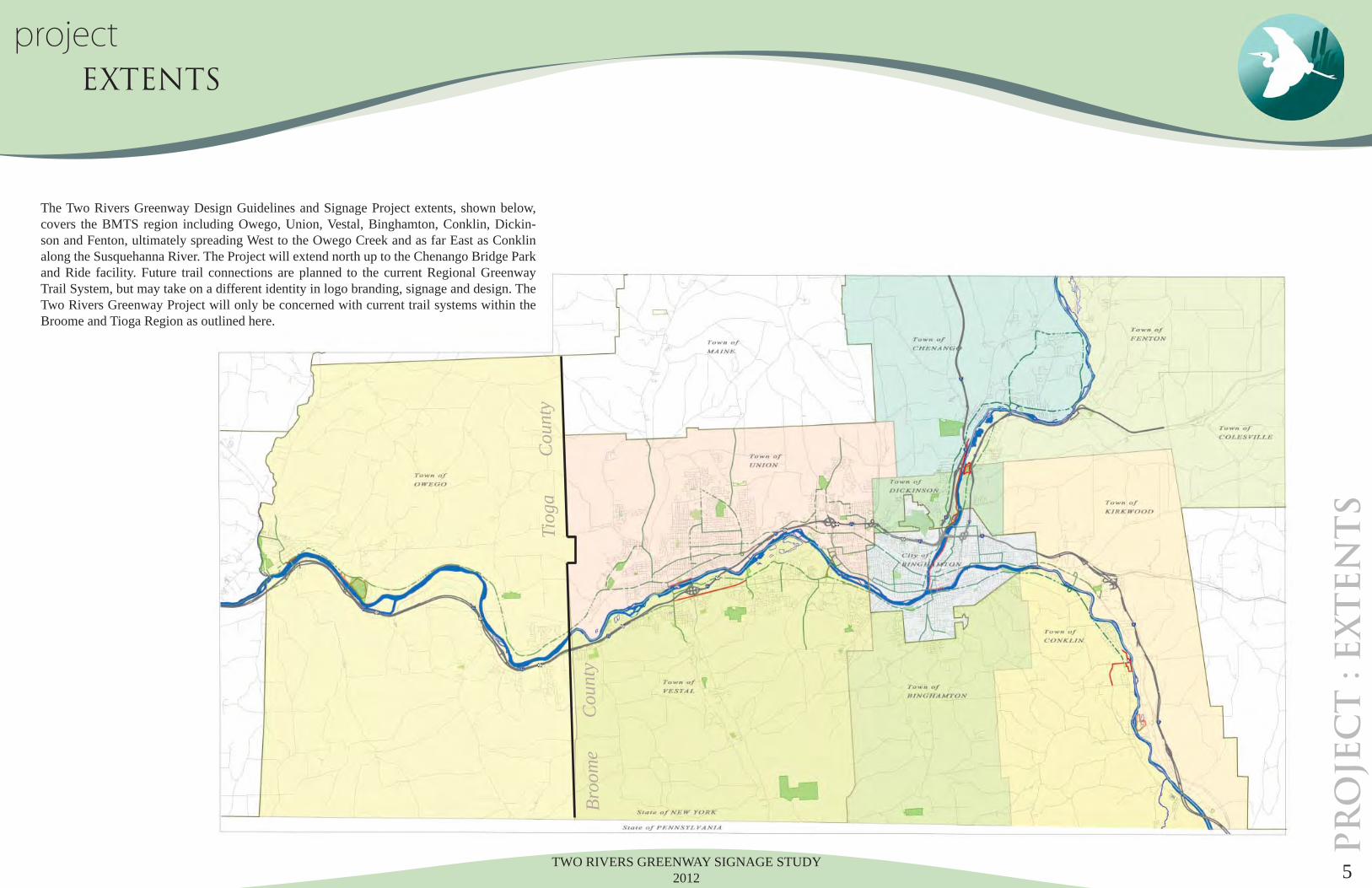
The Two Rivers Greenway Design Guidelines and Signage Project extents, shown below, covers the BMTS region including Owego, Union, Vestal, Binghamton, Conklin, Dickin-son and Fenton, ultimately spreading West to the Owego Creek and as far East as Conklin along the Susquehanna River. The Project will extend north up to the Chenango Bridge Park and Ride facility. Future trail connections are planned to the current Regional Greenway Trail System, but may take on a different identity in logo branding, signage and design. The Two Rivers Greenway Project will only be concerned with current trail systems within the Broome and Tioga Region as outlined here.
Tiog
a
C
ount
y
Broo
me
Cou
nty
TWO RIVERS GREENWAY SIGNAGE STUDY 20126
project GOALS & OBJECTIVES
Goal I.
Create a distinctive signage standard that will brand the Two Rivers Greenway Trail across two Counties. OBJECTIVES: • Use sign materials and forms already present throughout the Greenway Trail Segments. • Incorporate Native American, natural and cultural infl uences of this area into sign design form. • Develop a timeless and strong identifi able logo to brand the Greenway.
Goal II.
Increase trail usage and effi cient wayfi nding throughout the Greenway trail system.OBJECTIVES • Incorporate directional and orientation signage at key locations within the system to direct users to destinations. • Provide local wayfi nding points of interest in proximity to trail segments within a 1/2 mile radius. • Increase trail visibility from primary roadways through the use of ‘Trailblazer’ and Directional signs. • Provide destination distances up to 2 miles for municipalities and other neighboring trail segments of the Two Rivers Greenway.
Goal III.
Provide visitors with useful information about our cultural and historical identity.OBJECTIVES: • Provide interpretive panels where historic, cultural and ecological information or destinations are relevant and contextual. • Promote regional preservation and stewardship of the Susquehanna Heritage Area’s resources. • Strengthen regional identity through interpretation and education of the region’s history.
Goal IV.Provide elements for a marketing program to widen the audience, and promote the region’s historic, cultural and recreational attributes while increasing visits to the Susquehanna Heritage Area resources and Two Rivers Greenway.OBJECTIVES: • Brand an identity that captures the vision of the Two Rivers Greenway that can be used to market and promote the surrounding region. • Prepare appropriate sign types, maps, points of interest and graphic language to use in promotional media.
PR
OJE
CT
g
oa
ls &
objec
tiv
es

TWO RIVERS GREENWAY SIGNAGE STUDY 2012 7
IN
VE
NT
OR
Y : i
nt
ro
du
ct
io
n
inventory EXISTING SIGNAGE
Existing Signage.
As is typically the case in existing trail locations, there is often an assortment of forms, colors, materials and applications throughout the system. These include some well-conceived and consistent signage elements evident along Owego’s Riverwalk and Otsiningo Park that emphasize interpretation in the architectural sign forms. Usage and safety information is provided to trail goers along the Vestal Rail Trail. However, there are many portions of the existing trails that have little or no signage to identify trail access or direction or to acquaint visitors with the many heritage, recreational and entertainment offerings.
What is more, there is a dizzying array of graphic images projected on the trail or in adjacent neighborhoods and parklands through which the trails pass. Some of the images that can be seen in the vicinity of the trail are shown below.
Consequently, there is a tremendous opportunity to create both a uniform identity for the Two Rivers Greenway and standards for orienting and directing visi-tors. This will serve as a catalyst to forge a more collaborative effort to market the Greenway’s many opportunities.
TWO RIVERS GREENWAY SIGNAGE STUDY 20128
IN
VE
NT
OR
Y d
esig
n l
an
gu
ag
einventory DESIGN LANGUAGE
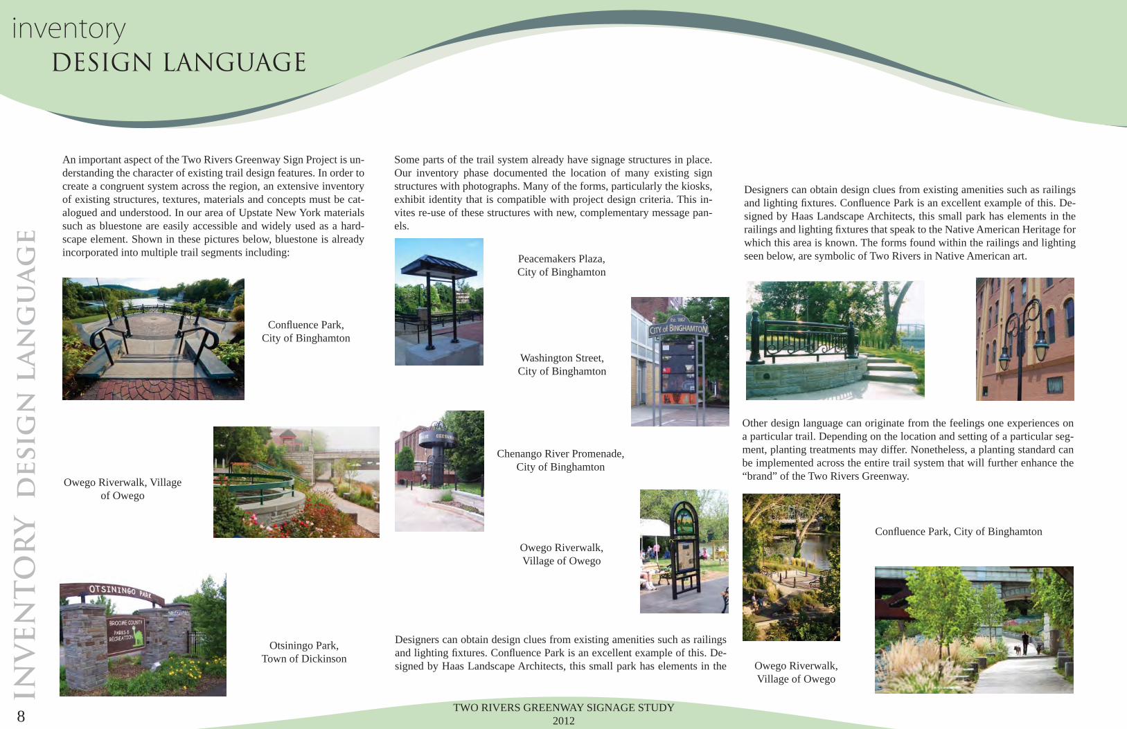
An important aspect of the Two Rivers Greenway Sign Project is un-derstanding the character of existing trail design features. In order to create a congruent system across the region, an extensive inventory of existing structures, textures, materials and concepts must be cat-alogued and understood. In our area of Upstate New York materials such as bluestone are easily accessible and widely used as a hard-scape element. Shown in these pictures below, bluestone is already incorporated into multiple trail segments including:
Some parts of the trail system already have signage structures in place. Our inventory phase documented the location of many existing sign structures with photographs. Many of the forms, particularly the kiosks, exhibit identity that is compatible with project design criteria. This in-vites re-use of these structures with new, complementary message pan-els.
Designers can obtain design clues from existing amenities such as railings and lighting fi xtures. Confl uence Park is an excellent example of this. De-signed by Haas Landscape Architects, this small park has elements in the
Designers can obtain design clues from existing amenities such as railings and lighting fi xtures. Confl uence Park is an excellent example of this. De-signed by Haas Landscape Architects, this small park has elements in the railings and lighting fi xtures that speak to the Native American Heritage for which this area is known. The forms found within the railings and lighting seen below, are symbolic of Two Rivers in Native American art.
Other design language can originate from the feelings one experiences on a particular trail. Depending on the location and setting of a particular seg-ment, planting treatments may differ. Nonetheless, a planting standard can be implemented across the entire trail system that will further enhance the “brand” of the Two Rivers Greenway.
Confl uence Park, City of Binghamton
Confl uence Park, City of Binghamton
Peacemakers Plaza, City of Binghamton
Washington Street, City of Binghamton
Chenango River Promenade, City of Binghamton
Owego Riverwalk, Village of Owego
Owego Riverwalk, Village of Owego
Owego Riverwalk, Villageof Owego
Otsiningo Park, Town of Dickinson
TWO RIVERS GREENWAY SIGNAGE STUDY 2012 9
LEGEND
Two Rivers Greenway Trail Segment
On-Road Bikeway
Proposed Two Rivers Greenway Trail Segment
Trailhead Locations
Parking Locations
Tourist Information
Park
Boat Launch
University
Natural Area
TRAIL TYPES TRAIL FACILITIES/SERVICES TRAIL ATTRACTIONS
IN
VE
NT
OR
Y O
weg
o T
ra
il S
eg
men
ts
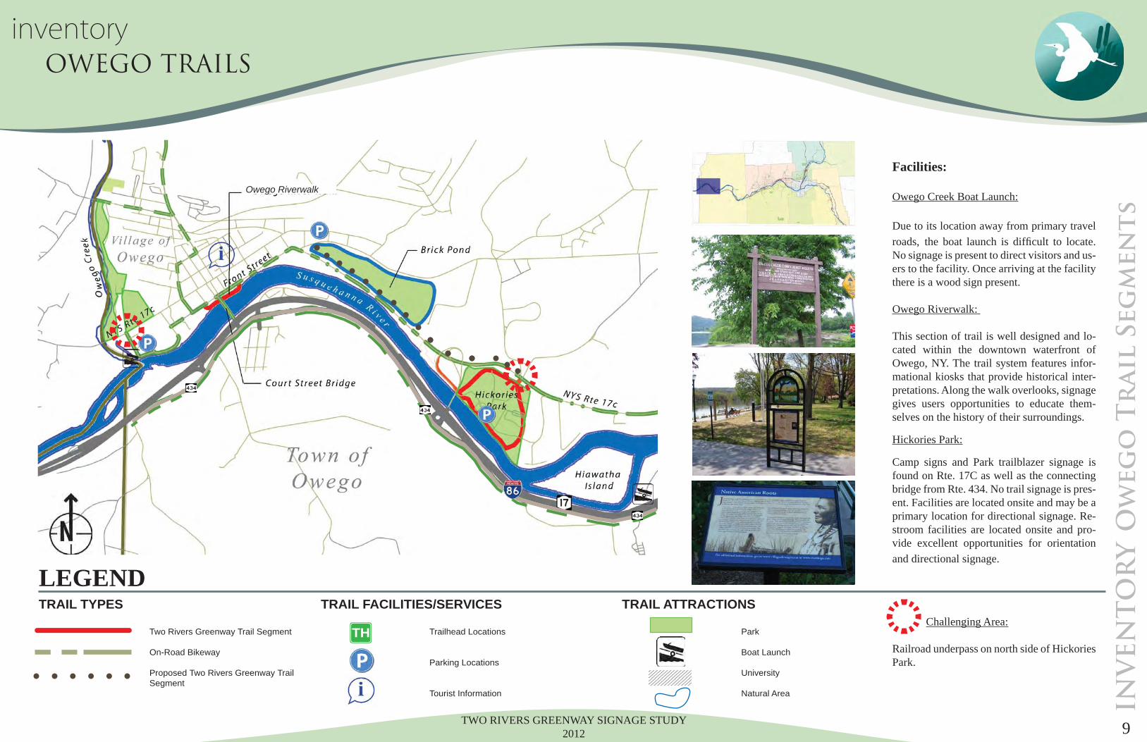
inventory OWEGO TRAILS
TH
Facilities:
Owego Creek Boat Launch: Due to its location away from primary travel roads, the boat launch is diffi cult to locate. No signage is present to direct visitors and us-ers to the facility. Once arriving at the facility there is a wood sign present.
Owego Riverwalk:
This section of trail is well designed and lo-cated within the downtown waterfront of Owego, NY. The trail system features infor-mational kiosks that provide historical inter-pretations. Along the walk overlooks, signage gives users opportunities to educate them-selves on the history of their surroundings.
Hickories Park:
Camp signs and Park trailblazer signage is found on Rte. 17C as well as the connecting bridge from Rte. 434. No trail signage is pres-ent. Facilities are located onsite and may be a primary location for directional signage. Re-stroom facilities are located onsite and pro-vide excellent opportunities for orientation and directional signage.
Challenging Area:
Railroad underpass on north side of Hickories Park.
Owego Riverwalk
TWO RIVERS GREENWAY SIGNAGE STUDY 201210
IN
VE
NT
OR
Y I
-8
6 S
eg
men
t
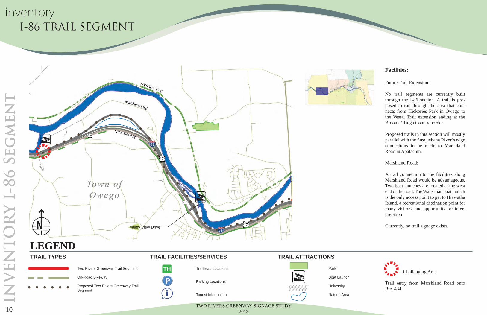
Facilities:
Future Trail Extension:
No trail segments are currently built through the I-86 section. A trail is pro-posed to run through the area that con-nects from Hickories Park in Owego to the Vestal Trail extension ending at the Broome/ Tioga County border.
Proposed trails in this section will mostly parallel with the Susquehana River’s edge connections to be made to Marshland Road in Apalachin.
Marshland Road: A trail connection to the facilities along Marshland Road would be advantageous. Two boat launches are located at the west end of the road. The Waterman boat launch is the only access point to get to Hiawatha Island, a recreational destination point for many visitors, and opportunity for inter-pretation
Currently, no trail signage exists.
Challenging Area
Trail entry from Marshland Road onto Rte. 434.
LEGEND
Two Rivers Greenway Trail Segment
On-Road Bikeway
Proposed Two Rivers Greenway Trail Segment
Trailhead Locations
Parking Locations
Tourist Information
Park
Boat Launch
University
Natural Area
TRAIL TYPES TRAIL FACILITIES/SERVICES TRAIL ATTRACTIONS
TH
inventory I-86 TRAIL SEGMENT
Valley View Drive
TWO RIVERS GREENWAY SIGNAGE STUDY 2012 11
IN
VE
NT
OR
Y V
estal T
rails W
est
Facilities:
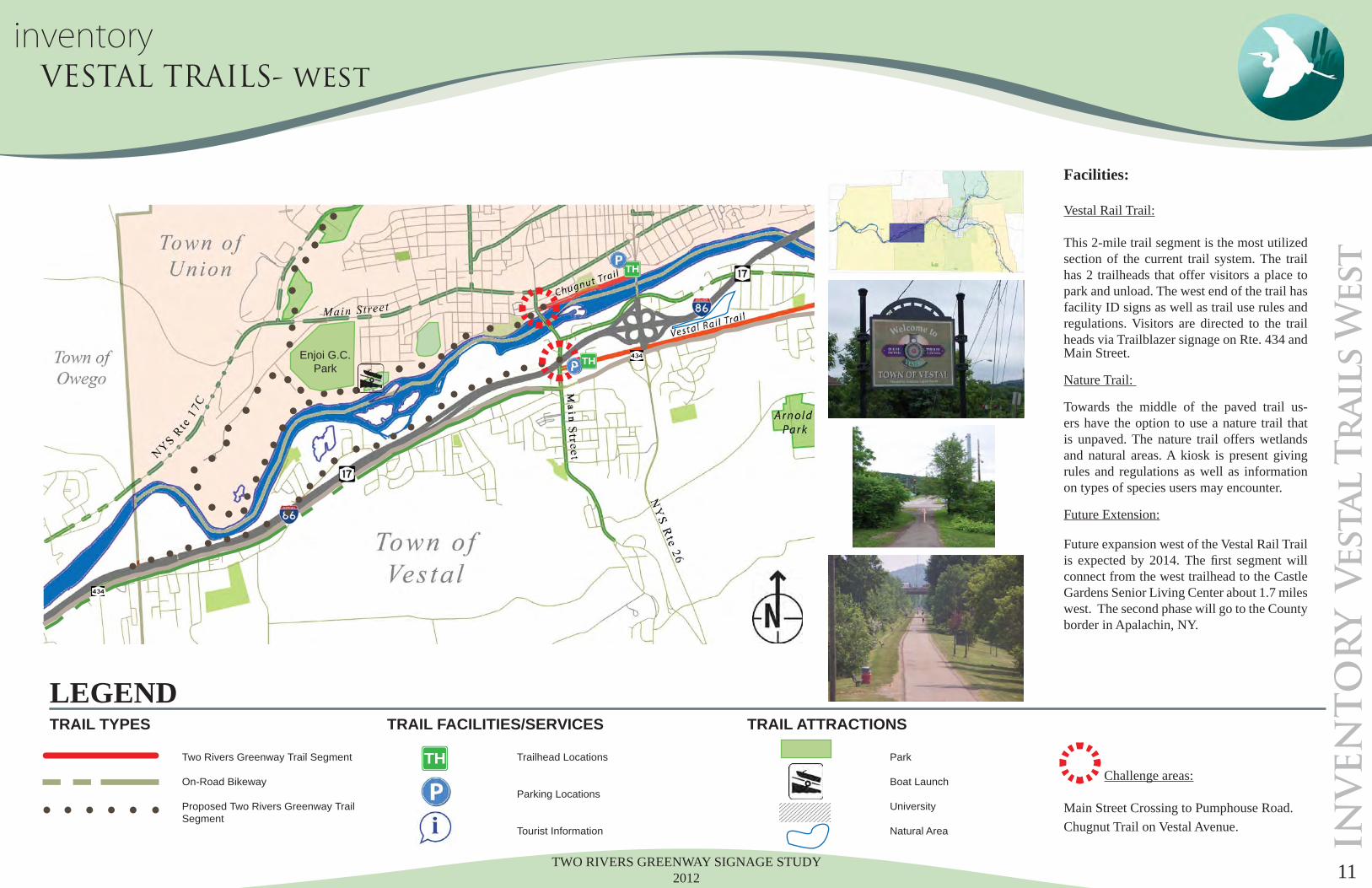
Vestal Rail Trail:
This 2-mile trail segment is the most utilized section of the current trail system. The trail has 2 trailheads that offer visitors a place to park and unload. The west end of the trail has facility ID signs as well as trail use rules and regulations. Visitors are directed to the trail heads via Trailblazer signage on Rte. 434 and Main Street.
Nature Trail: Towards the middle of the paved trail us-ers have the option to use a nature trail that is unpaved. The nature trail offers wetlands and natural areas. A kiosk is present giving rules and regulations as well as information on types of species users may encounter.
Future Extension:
Future expansion west of the Vestal Rail Trail is expected by 2014. The fi rst segment will connect from the west trailhead to the Castle Gardens Senior Living Center about 1.7 miles west. The second phase will go to the County border in Apalachin, NY.
Challenge areas:
Main Street Crossing to Pumphouse Road. Chugnut Trail on Vestal Avenue.
TH
TH
LEGEND
Two Rivers Greenway Trail Segment
On-Road Bikeway
Proposed Two Rivers Greenway Trail Segment
Trailhead Locations
Parking Locations
Tourist Information
Park
Boat Launch
University
Natural Area
TRAIL TYPES TRAIL FACILITIES/SERVICES TRAIL ATTRACTIONS
TH
TTTTTTTT
T
inventory VESTAL TRAILS- west
Enjoi G.C.Park
TWO RIVERS GREENWAY SIGNAGE STUDY 201212
IN
VE
NT
OR
Y V
estal T
rails E
ast
TH
TH
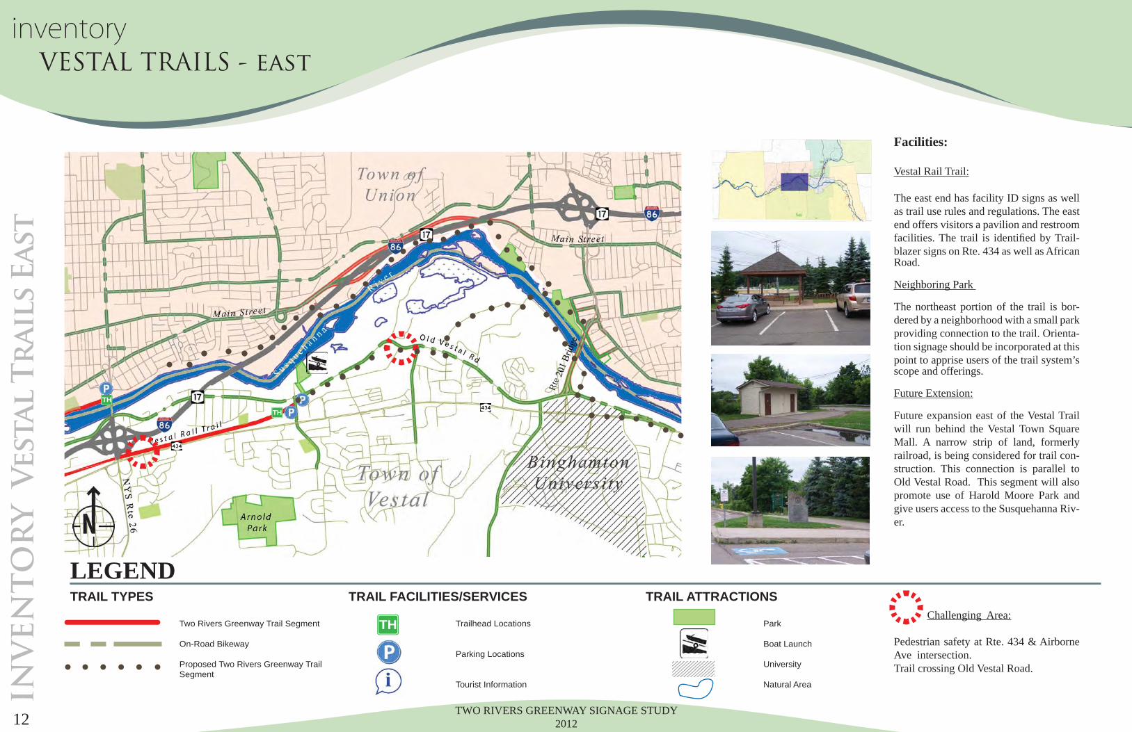
Facilities:
Vestal Rail Trail:
The east end has facility ID signs as well as trail use rules and regulations. The east end offers visitors a pavilion and restroom facilities. The trail is identifi ed by Trail-blazer signs on Rte. 434 as well as African Road.
Neighboring Park The northeast portion of the trail is bor-dered by a neighborhood with a small park providing connection to the trail. Orienta-tion signage should be incorporated at this point to apprise users of the trail system’s scope and offerings.
Future Extension:
Future expansion east of the Vestal Trail will run behind the Vestal Town Square Mall. A narrow strip of land, formerly railroad, is being considered for trail con-struction. This connection is parallel to Old Vestal Road. This segment will also promote use of Harold Moore Park and give users access to the Susquehanna Riv-er.
Challenging Area:
Pedestrian safety at Rte. 434 & Airborne Ave intersection. Trail crossing Old Vestal Road.
LEGEND
Two Rivers Greenway Trail Segment
On-Road Bikeway
Proposed Two Rivers Greenway Trail Segment
Trailhead Locations
Parking Locations
Tourist Information
Park
Boat Launch
University
Natural Area
TRAIL TYPES TRAIL FACILITIES/SERVICES TRAIL ATTRACTIONS
TH
inventory VESTAL TRAILS - east
Rte
TWO RIVERS GREENWAY SIGNAGE STUDY 2012 13
IN
VE
NT
OR
Y U
nio
n T
rails W
est
TH
TH
Facilities:
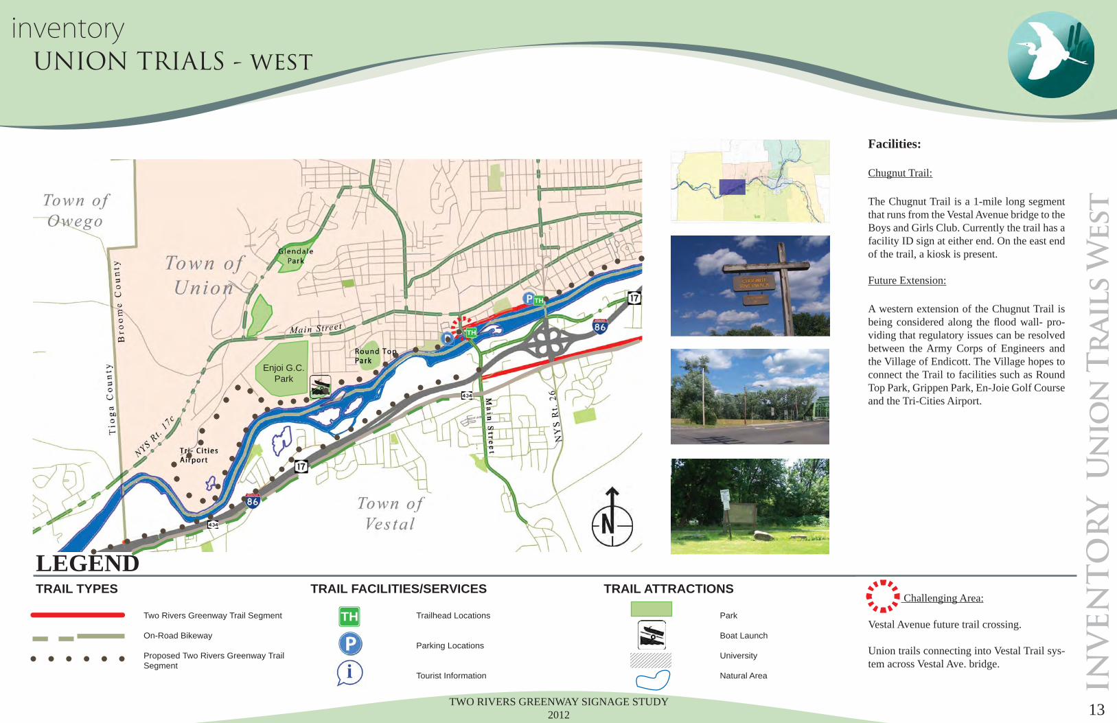
Chugnut Trail: The Chugnut Trail is a 1-mile long segment that runs from the Vestal Avenue bridge to the Boys and Girls Club. Currently the trail has a facility ID sign at either end. On the east end of the trail, a kiosk is present.
Future Extension:
A western extension of the Chugnut Trail is being considered along the fl ood wall- pro-viding that regulatory issues can be resolved between the Army Corps of Engineers and the Village of Endicott. The Village hopes to connect the Trail to facilities such as Round Top Park, Grippen Park, En-Joie Golf Course and the Tri-Cities Airport.
Challenging Area:
Vestal Avenue future trail crossing.
Union trails connecting into Vestal Trail sys-tem across Vestal Ave. bridge.
LEGEND
Two Rivers Greenway Trail Segment
On-Road Bikeway
Proposed Two Rivers Greenway Trail Segment
Trailhead Locations
Parking Locations
Tourist Information
Park
Boat Launch
University
Natural Area
TRAIL TYPES TRAIL FACILITIES/SERVICES TRAIL ATTRACTIONS
TH
inventory UNION TRIALS - west
Enjoi G.C.Park
TWO RIVERS GREENWAY SIGNAGE STUDY 201214
IN
VE
NT
OR
Y U
nio
n T
rails E
ast
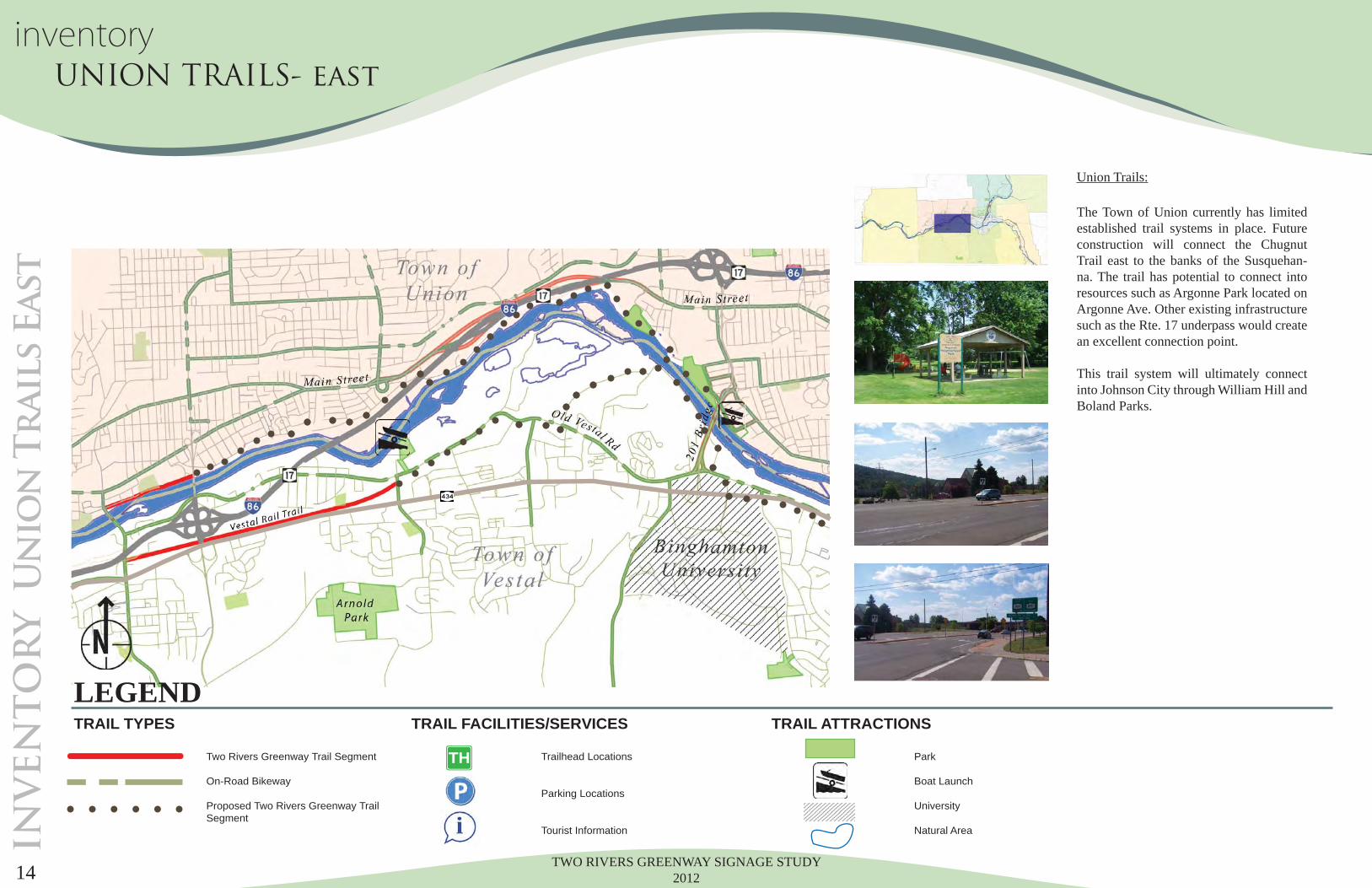
Union Trails: The Town of Union currently has limited established trail systems in place. Future construction will connect the Chugnut Trail east to the banks of the Susquehan-na. The trail has potential to connect into resources such as Argonne Park located on Argonne Ave. Other existing infrastructure such as the Rte. 17 underpass would create an excellent connection point.
This trail system will ultimately connect into Johnson City through William Hill and Boland Parks.
LEGEND
Two Rivers Greenway Trail Segment
On-Road Bikeway
Proposed Two Rivers Greenway Trail Segment
Trailhead Locations
Parking Locations
Tourist Information
Park
Boat Launch
University
Natural Area
TRAIL TYPES TRAIL FACILITIES/SERVICES TRAIL ATTRACTIONS
TH
inventory UNION TRAILS- east
TWO RIVERS GREENWAY SIGNAGE STUDY 2012 15
IN
VE
NT
OR
Y V
estal P
arkw
ay T
rail
TH
TH
HH
Facilities:
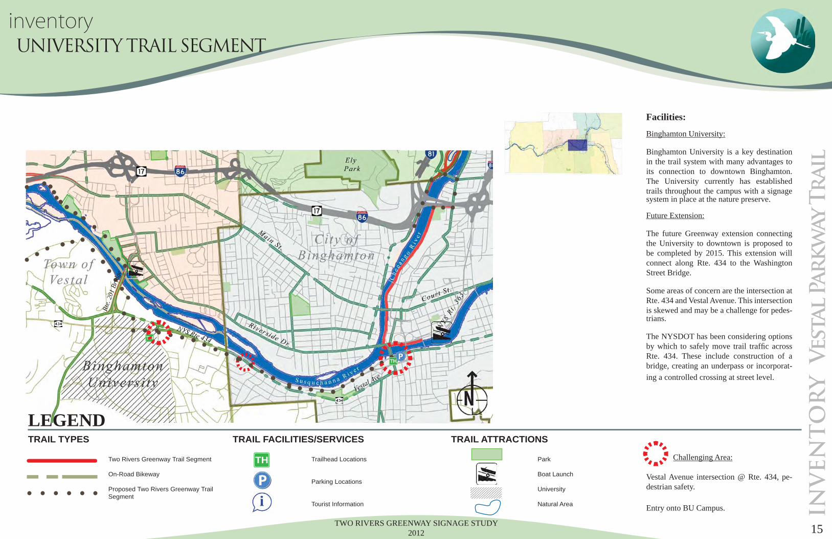
Binghamton University: Binghamton University is a key destination in the trail system with many advantages to its connection to downtown Binghamton. The University currently has established trails throughout the campus with a signage system in place at the nature preserve.
Future Extension:
The future Greenway extension connecting the University to downtown is proposed to be completed by 2015. This extension will connect along Rte. 434 to the Washington Street Bridge.
Some areas of concern are the intersection at Rte. 434 and Vestal Avenue. This intersection is skewed and may be a challenge for pedes-trians.
The NYSDOT has been considering options by which to safely move trail traffi c across Rte. 434. These include construction of a bridge, creating an underpass or incorporat-ing a controlled crossing at street level.
Challenging Area:
Vestal Avenue intersection @ Rte. 434, pe-destrian safety.
Entry onto BU Campus.
LEGEND
Two Rivers Greenway Trail Segment
On-Road Bikeway
Proposed Two Rivers Greenway Trail Segment
Trailhead Locations
Parking Locations
Tourist Information
Park
Boat Launch
University
Natural Area
TRAIL TYPES TRAIL FACILITIES/SERVICES TRAIL ATTRACTIONS
TH
inventory UNIVERSITY TRAIL SEGMENT
Rte.
201
Brid
ge
TWO RIVERS GREENWAY SIGNAGE STUDY 201216
IN
VE
NT
OR
Y C
ity o
f B
ing
ham
to
n
TH
TH
LEGEND
Two Rivers Greenway Trail Segment
On-Road Bikeway
Proposed Two Rivers Greenway Trail Segment
Trailhead Locations
Parking Locations
Tourist Information
Park
Boat Launch
University
Natural Area
TRAIL TYPES TRAIL FACILITIES/SERVICES TRAIL ATTRACTIONS
TH
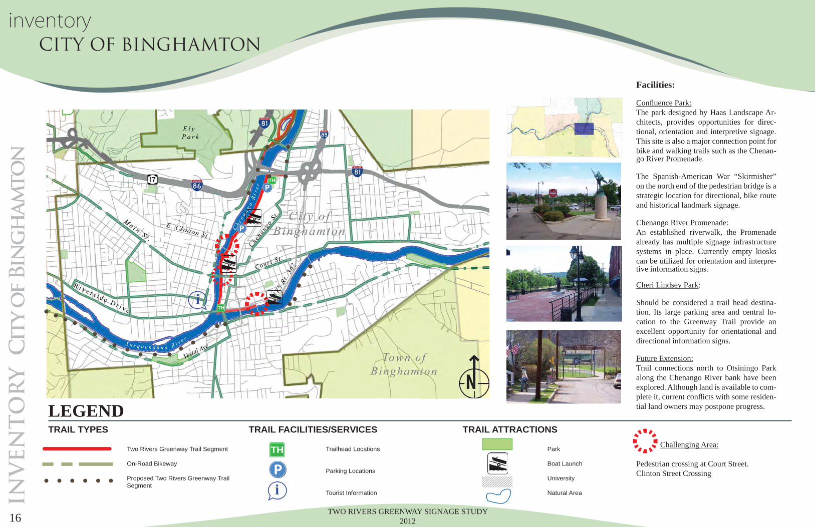
inventory CITY OF BINGHAMTON
Facilities:
Confl uence Park:The park designed by Haas Landscape Ar-chitects, provides opportunities for direc-tional, orientation and interpretive signage. This site is also a major connection point for bike and walking trails such as the Chenan-go River Promenade.
The Spanish-American War “Skirmisher” on the north end of the pedestrian bridge is a strategic location for directional, bike route and historical landmark signage.
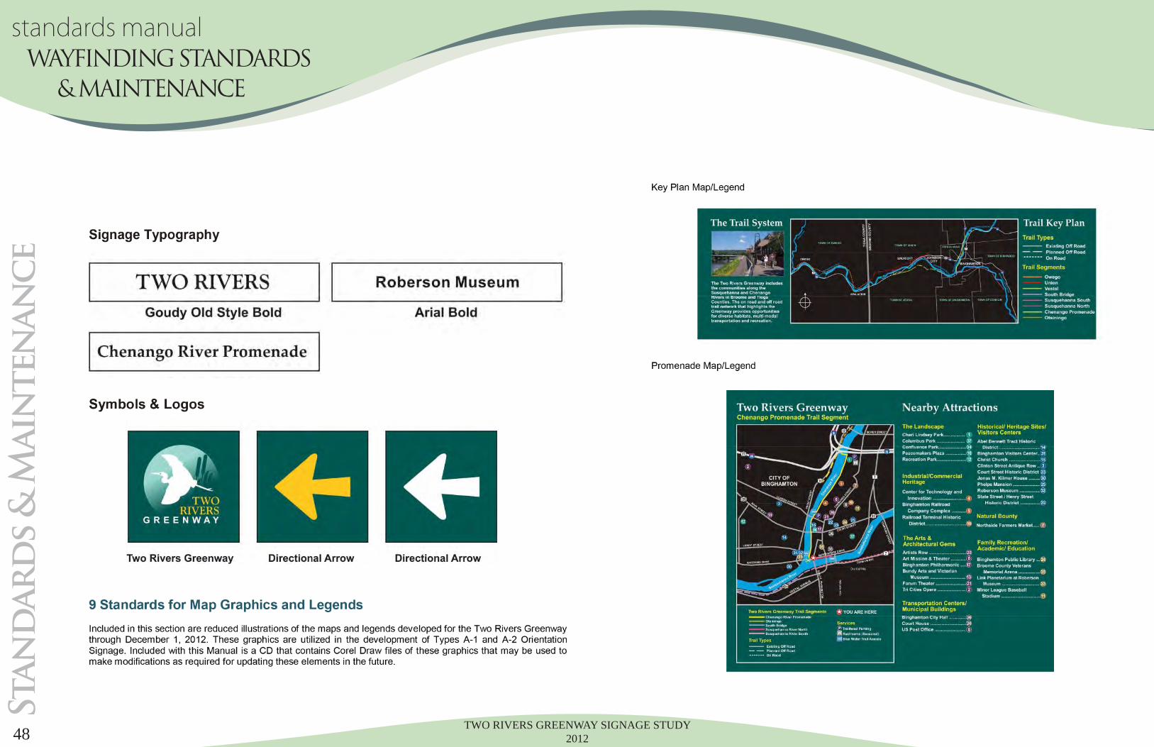
Chenango River Promenade:An established riverwalk, the Promenade already has multiple signage infrastructure systems in place. Currently empty kiosks can be utilized for orientation and interpre-tive information signs.
Cheri Lindsey Park:
Should be considered a trail head destina-tion. Its large parking area and central lo-cation to the Greenway Trail provide an excellent opportunity for orientational and directional information signs.
Future Extension:Trail connections north to Otsiningo Park along the Chenango River bank have been explored. Although land is available to com-plete it, current confl icts with some residen-tial land owners may postpone progress.
Challenging Area:
Pedestrian crossing at Court Street.Clinton Street Crossing
TWO RIVERS GREENWAY SIGNAGE STUDY 2012 17
IN
VE
NT
OR
Y O
tsin
in
go
pa
rk
TH
Facilities:
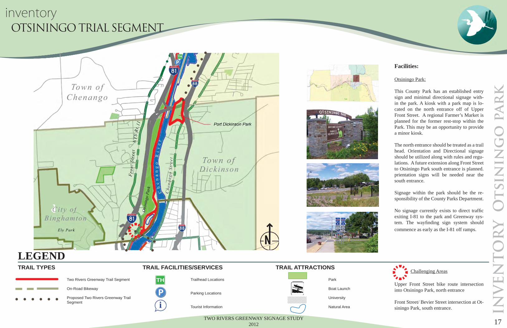
Otsiningo Park:
This County Park has an established entry sign and minimal directional signage with-in the park. A kiosk with a park map is lo-cated on the north entrance off of Upper Front Street. A regional Farmer’s Market is planned for the former rest-stop within the Park. This may be an opportunity to provide a minor kiosk.
The north entrance should be treated as a trail head. Orientation and Directional signage should be utilized along with rules and regu-lations. A future extension along Front Street to Otsiningo Park south entrance is planned. prientation signs will be needed near the south entrance.
Signage within the park should be the re-sponsibility of the County Parks Department.
No signage currently exists to direct traffi c exiting I-81 to the park and Greenway sys-tem. The wayfi nding sign system should commence as early as the I-81 off ramps.
Challenging Areas Upper Front Street bike route intersection into Otsiningo Park, north entrance
Front Street/ Bevier Street intersection at Ot-siningo Park, south entrance.
LEGEND
Two Rivers Greenway Trail Segment
On-Road Bikeway
Proposed Two Rivers Greenway Trail Segment
Trailhead Locations
Parking Locations
Tourist Information
Park
Boat Launch
University
Natural Area
TRAIL TYPES TRAIL FACILITIES/SERVICES TRAIL ATTRACTIONS
TH
inventory OTSININGO TRIAL SEGMENT
TWO RIVERS GREENWAY SIGNAGE STUDY 201218
IN
VE
NT
OR
Y C
hen
an
go
Br
id
ge
TH
Facilities:
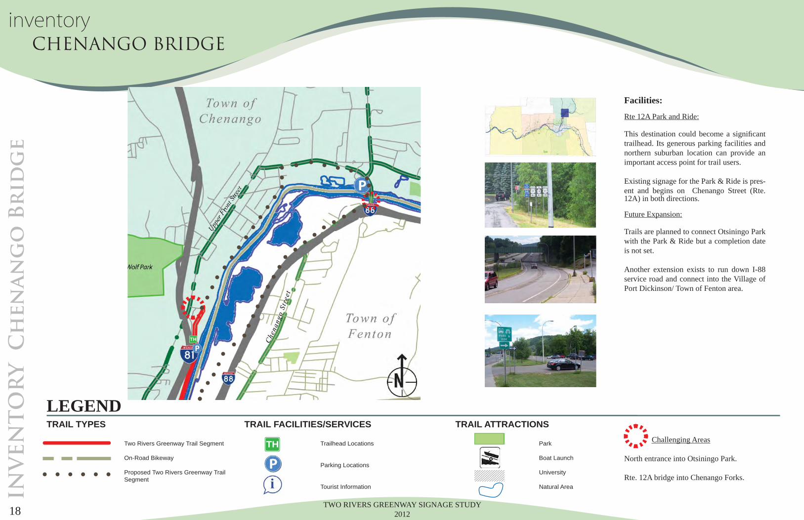
Rte 12A Park and Ride:
This destination could become a signifi cant trailhead. Its generous parking facilities and northern suburban location can provide an important access point for trail users.
Existing signage for the Park & Ride is pres-ent and begins on Chenango Street (Rte. 12A) in both directions.
Future Expansion:
Trails are planned to connect Otsiningo Park with the Park & Ride but a completion date is not set.
Another extension exists to run down I-88 service road and connect into the Village of Port Dickinson/ Town of Fenton area.
Challenging Areas
North entrance into Otsiningo Park.
Rte. 12A bridge into Chenango Forks.
LEGEND
Two Rivers Greenway Trail Segment
On-Road Bikeway
Proposed Two Rivers Greenway Trail Segment
Trailhead Locations
Parking Locations
Tourist Information
Park
Boat Launch
University
Natural Area
TRAIL TYPES TRAIL FACILITIES/SERVICES TRAIL ATTRACTIONS
TH
inventory CHENANGO BRIDGE
TWO RIVERS GREENWAY SIGNAGE STUDY 2012 19
INVEN
TO
RY P
ort D
ick
inso
n/ F
en
to
n
TH
Facilities:
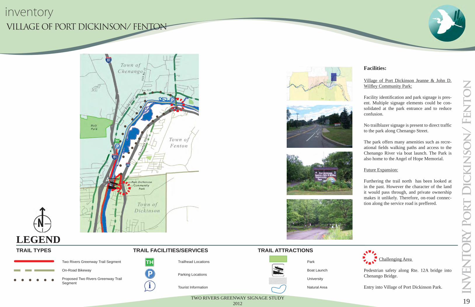
Village of Port Dickinson Jeanne & John D. Wilfl ey Community Park:
Facility identifi cation and park signage is pres-ent. Multiple signage elements could be con-solidated at the park entrance and to reduce confusion.
No trailblazer signage is present to direct traffi c to the park along Chenango Street.
The park offers many amenities such as recre-ational fi elds walking paths and access to the Chenango River via boat launch. The Park is also home to the Angel of Hope Memorial.
Future Expansion:
Furthering the trail north has been looked at in the past. However the character of the land it would pass through, and private ownership makes it unlikely. Therefore, on-road connec-tion along the service road is preffered.
Challenging Area
Pedestrian safety along Rte. 12A bridge into Chenango Bridge.
Entry into Village of Port Dickinson Park.
LEGEND
Two Rivers Greenway Trail Segment
On-Road Bikeway
Proposed Two Rivers Greenway Trail Segment
Trailhead Locations
Parking Locations
Tourist Information
Park
Boat Launch
University
Natural Area
TRAIL TYPES TRAIL FACILITIES/SERVICES TRAIL ATTRACTIONS
TH
inventory VILLAGE OF PORT DICKINSON/ FENTON
TWO RIVERS GREENWAY SIGNAGE STUDY 201220
INVEN
TO
RY to
wo
n o
f C
on
klin
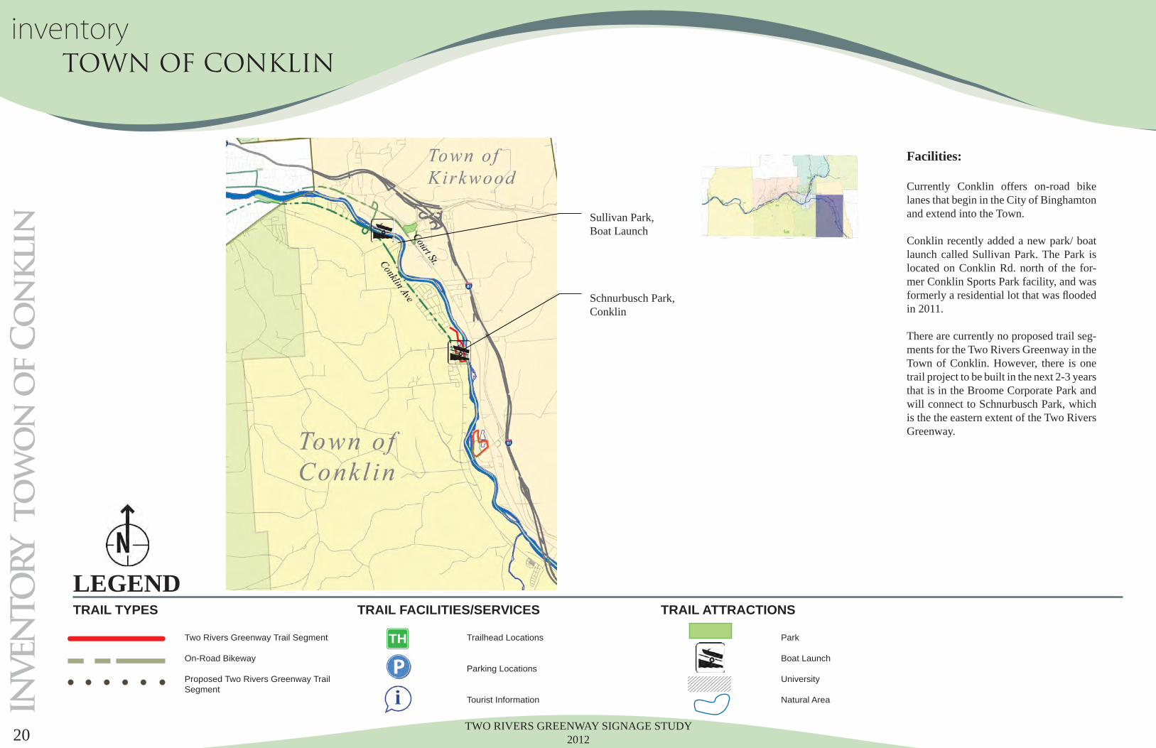
Facilities:
Currently Conklin offers on-road bike lanes that begin in the City of Binghamton and extend into the Town.
Conklin recently added a new park/ boat launch called Sullivan Park. The Park is located on Conklin Rd. north of the for-mer Conklin Sports Park facility, and was formerly a residential lot that was fl ooded in 2011.
There are currently no proposed trail seg-ments for the Two Rivers Greenway in the Town of Conklin. However, there is one trail project to be built in the next 2-3 years that is in the Broome Corporate Park and will connect to Schnurbusch Park, which is the the eastern extent of the Two Rivers Greenway.
LEGEND
Two Rivers Greenway Trail Segment
On-Road Bikeway
Proposed Two Rivers Greenway Trail Segment
Trailhead Locations
Parking Locations
Tourist Information
Park
Boat Launch
University
Natural Area
TRAIL TYPES TRAIL FACILITIES/SERVICES TRAIL ATTRACTIONS
TH
Schnurbusch Park, Conklin
Sullivan Park, Boat Launch
inventory TOWN OF CONKLIN
TWO RIVERS GREENWAY SIGNAGE STUDY 2012 21
INVEN
TO
RY o
f d
estin
atio
ns
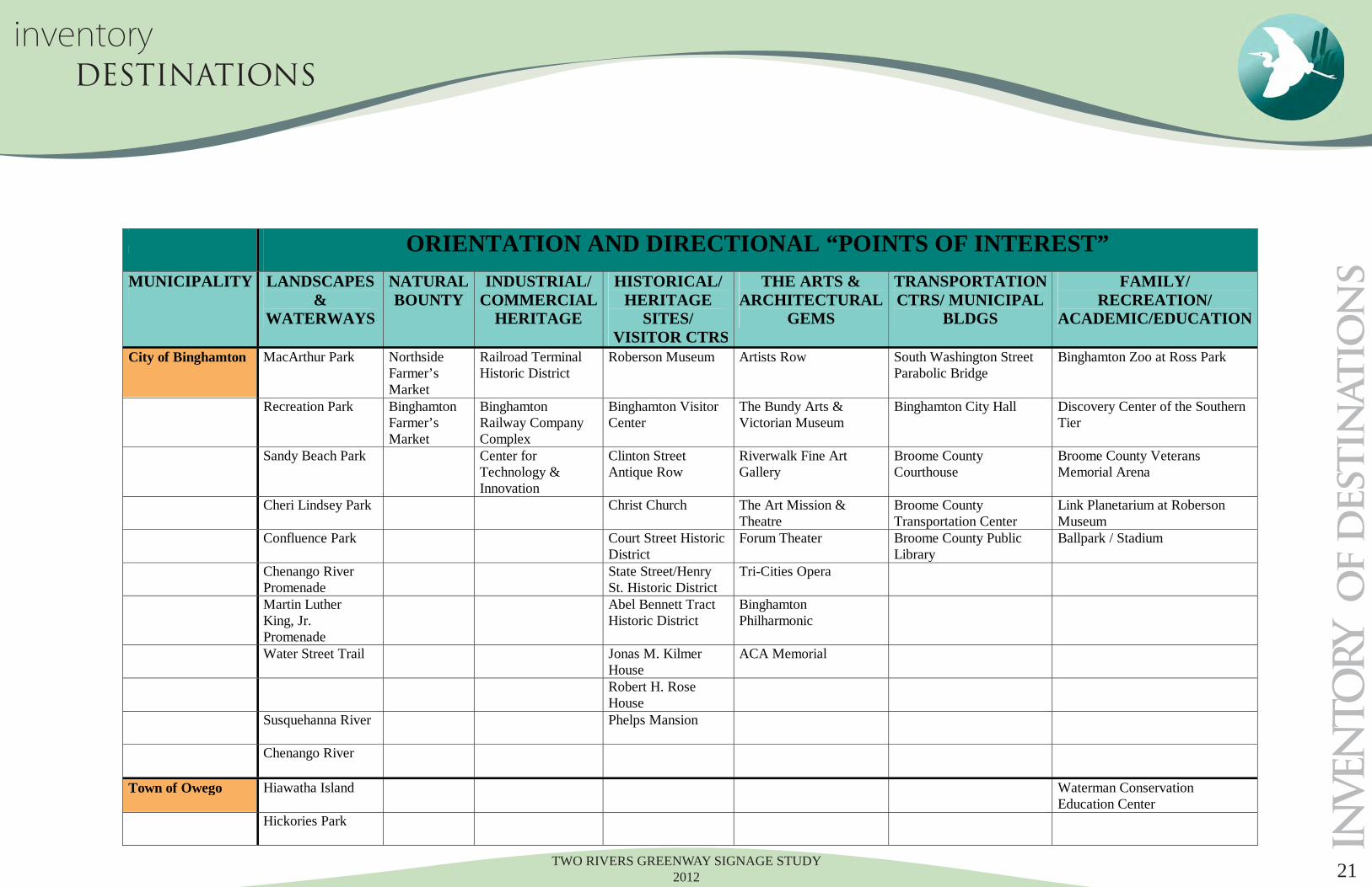
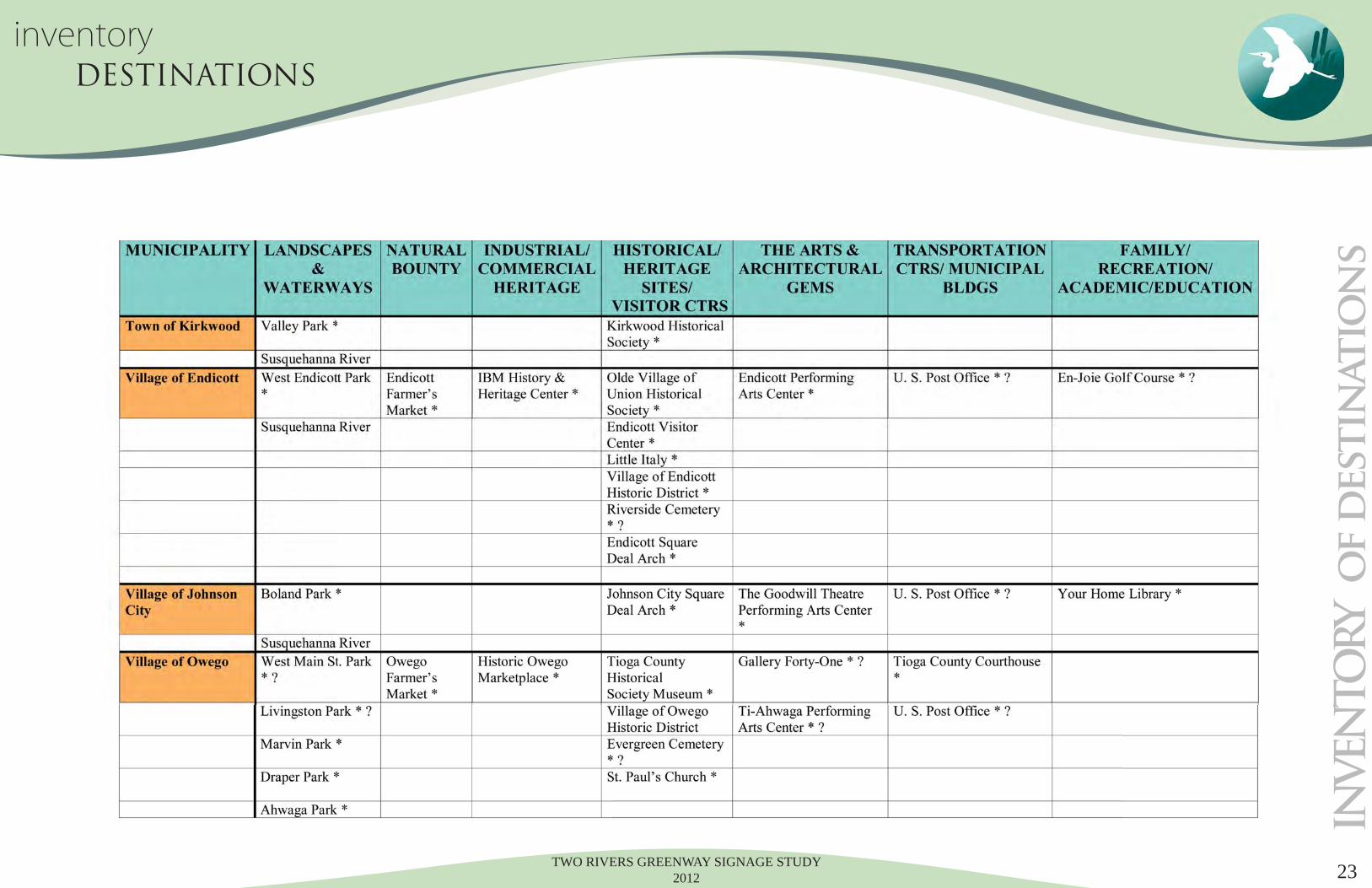
All except Vestal ORIENTATION AND DIRECTIONAL “POINTS OF INTEREST” MUNICIPALITY LANDSCAPES
& WATERWAYS
NATURAL BOUNTY
INDUSTRIAL/ COMMERCIAL
HERITAGE
HISTORICAL/ HERITAGE
SITES/ VISITOR CTRS
THE ARTS & ARCHITECTURAL
GEMS
TRANSPORTATION CTRS/ MUNICIPAL
BLDGS
FAMILY/ RECREATION/
ACADEMIC/EDUCATION
City of Binghamton MacArthur Park Northside Farmer’s Market
Railroad Terminal Historic District
Roberson Museum Artists Row South Washington Street Parabolic Bridge
Binghamton Zoo at Ross Park
Recreation Park Binghamton Farmer’s Market
Binghamton Railway Company Complex
Binghamton Visitor Center
The Bundy Arts & Victorian Museum
Binghamton City Hall Discovery Center of the Southern Tier
Sandy Beach Park Center for Technology & Innovation
Clinton Street Antique Row
Riverwalk Fine Art Gallery
Broome County Courthouse
Broome County Veterans Memorial Arena
Cheri Lindsey Park Christ Church
The Art Mission & Theatre
Broome County Transportation Center
Link Planetarium at Roberson Museum
Confluence Park Court Street Historic District
Forum Theater
Broome County Public Library
Ballpark / Stadium
Chenango River Promenade
State Street/Henry St. Historic District
Tri-Cities Opera
Martin Luther King, Jr. Promenade
Abel Bennett Tract Historic District
Binghamton Philharmonic
Water Street Trail Jonas M. Kilmer House
ACA Memorial
Robert H. Rose House
Susquehanna River
Phelps Mansion
Chenango River
Town of Owego Hiawatha Island Waterman Conservation Education Center
Hickories Park
inventory DESTINATIONS
TWO RIVERS GREENWAY SIGNAGE STUDY 201222
INVEN
TO
RY o
f d
estin
atio
ns
inventory DESTINATIONS
TWO RIVERS GREENWAY SIGNAGE STUDY 2012 23
INVEN
TO
RY o
f d
estin
atio
ns
inventory DESTINATIONS
TWO RIVERS GREENWAY SIGNAGE STUDY 201224
Lo
ca
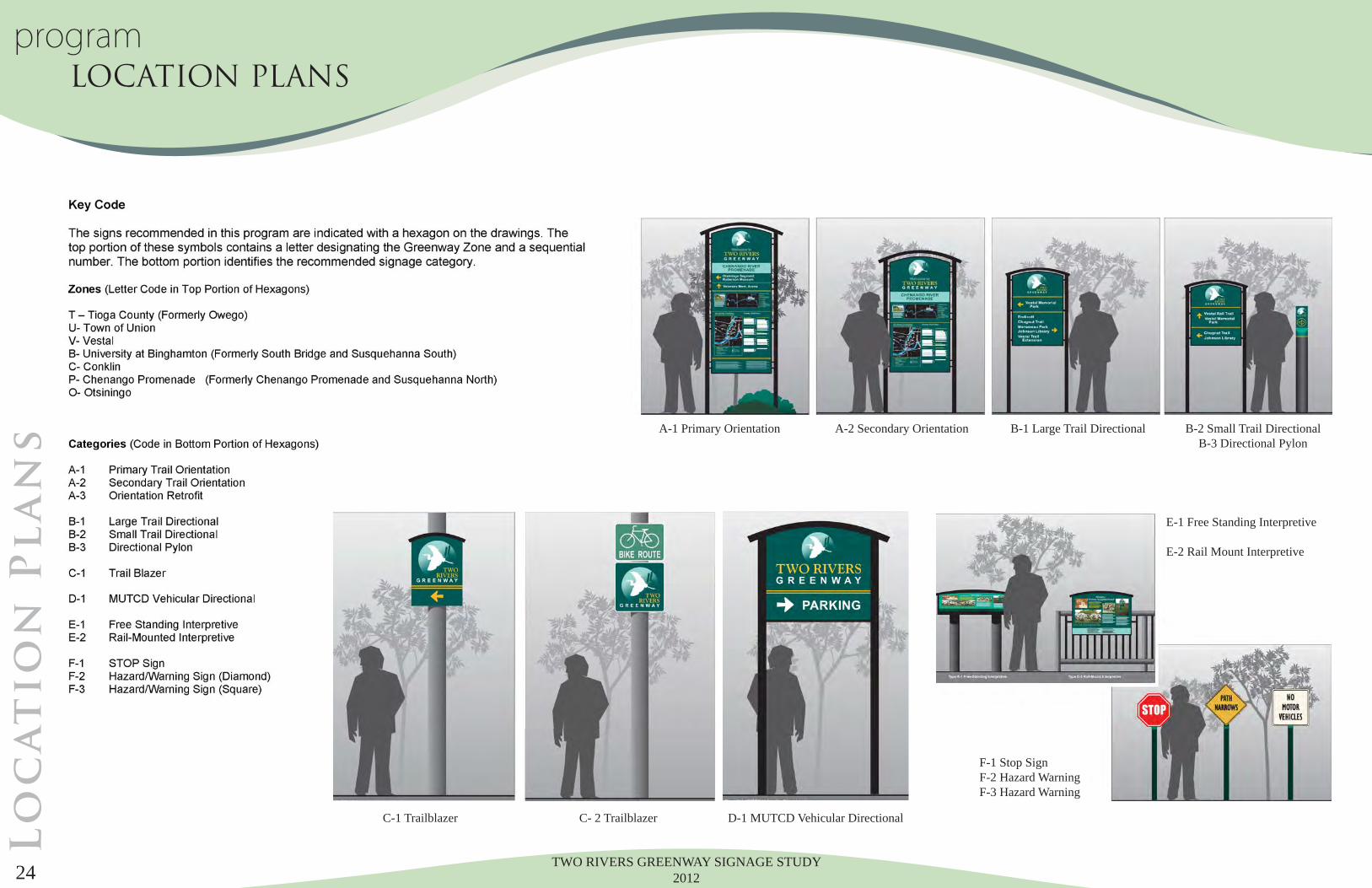
tio
n P
la
ns
C-1 Trailblazer C- 2 Trailblazer D-1 MUTCD Vehicular Directional
A-1 Primary Orientation A-2 Secondary Orientation B-1 Large Trail Directional B-2 Small Trail DirectionalB-3 Directional Pylon
E-1 Free Standing Interpretive
E-2 Rail Mount Interpretive
F-1 Stop SignF-2 Hazard WarningF-3 Hazard Warning
programLOCATION PLANS
TWO RIVERS GREENWAY SIGNAGE STUDY 2012 25
T6A-1
T3A-2
T4E-1
T2C-1
T1C-1
T5C-1
T7B-1
T10C-1
T14C-1
T15C-1
T11C-1
T13B-1
T12A-1
T17C-2
T18C-2
T18C-2
T18C-2
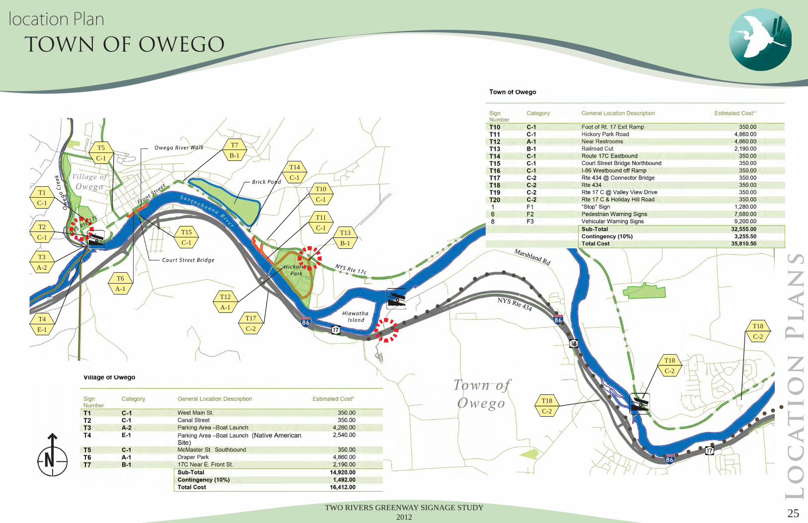
location Plan TOWN OF OWEGO
Lo
ca
tio
n P
la
ns
TWO RIVERS GREENWAY SIGNAGE STUDY 201226
V1B-1
V2C-1
V5D-1
V3C-1
V4A-1
V6B-2
V15C-1
V10B-2
V11B-1
V17E-1
V12B-1 V13
A-1
B1B-1
V14D-1
V16C-1
B2A-1
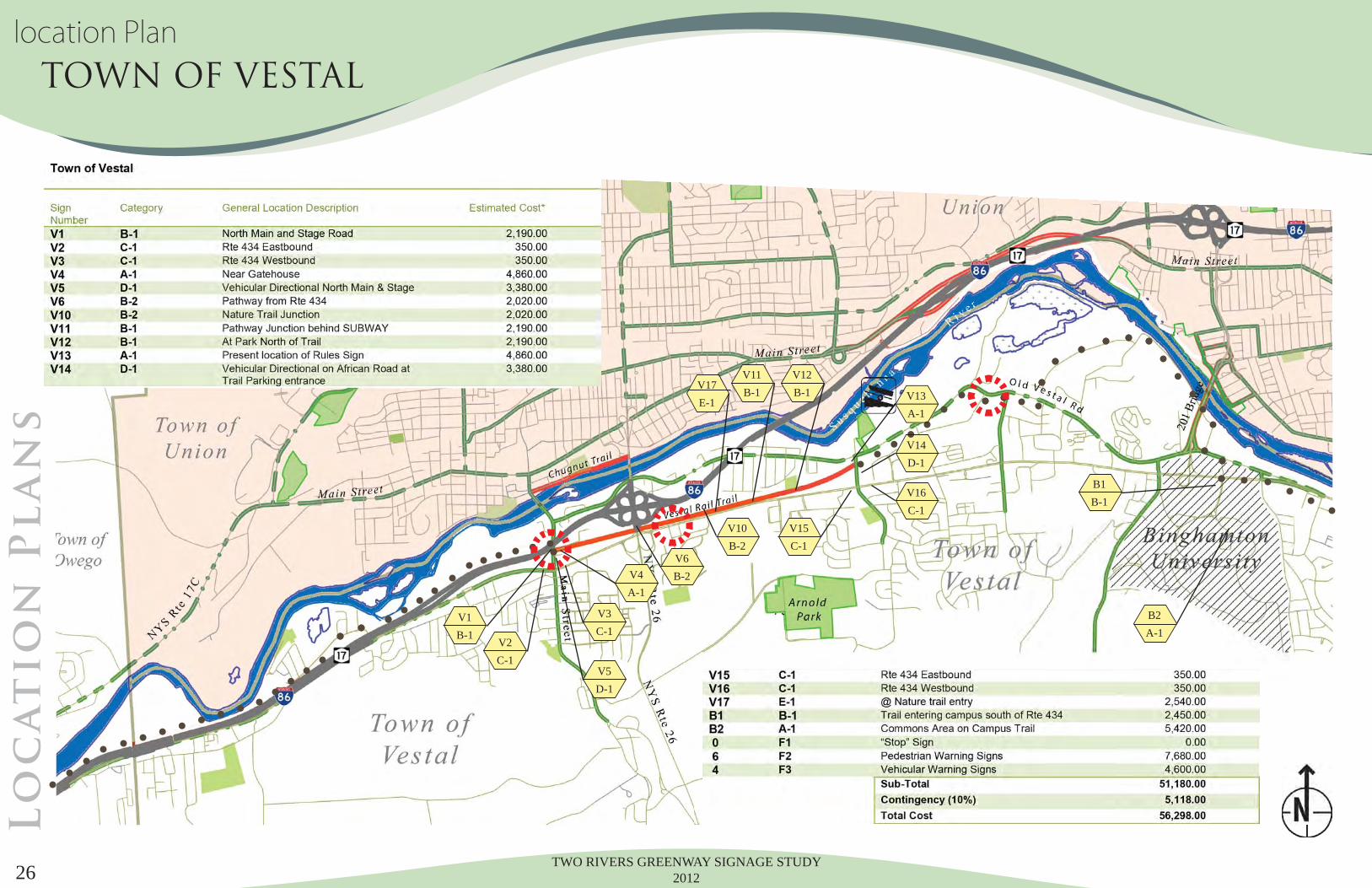
location Plan TOWN OF VESTALL
oc
at
io
n P
la
ns
TWO RIVERS GREENWAY SIGNAGE STUDY 2012 27
U3A-1
U6A-1
U5C-1
U4C-1
U2C-1
U1B-1
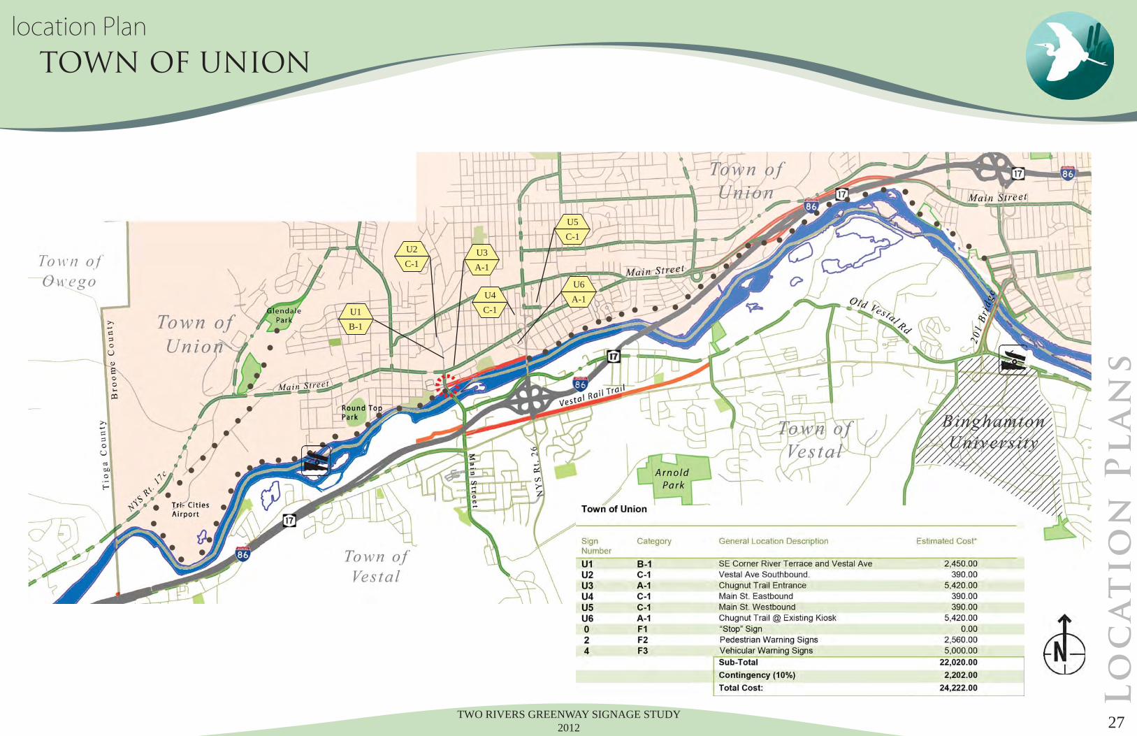
location Plan TOWN OF UNION
Lo
ca
tio
n P
la
ns
TWO RIVERS GREENWAY SIGNAGE STUDY 201228
P8A-3
P5C-1
P21C-1
P24C-1
P26C-1
P27C-1
P30A-1
P34C-1
P35C-1
P36C-1
P33C-1
P32C-1
O1C-1
P31C-1
P28A-1
P23C-1
P20A-1
P16B-2
P13A-2
P12B-1
P10A-1
P2B-1P4
C-1
P3B-1
P1B-1
P11C-1
P22C-1
P22aC-1
P25C-1
P15C-1
P14A-3
P6A-1
P7C-1
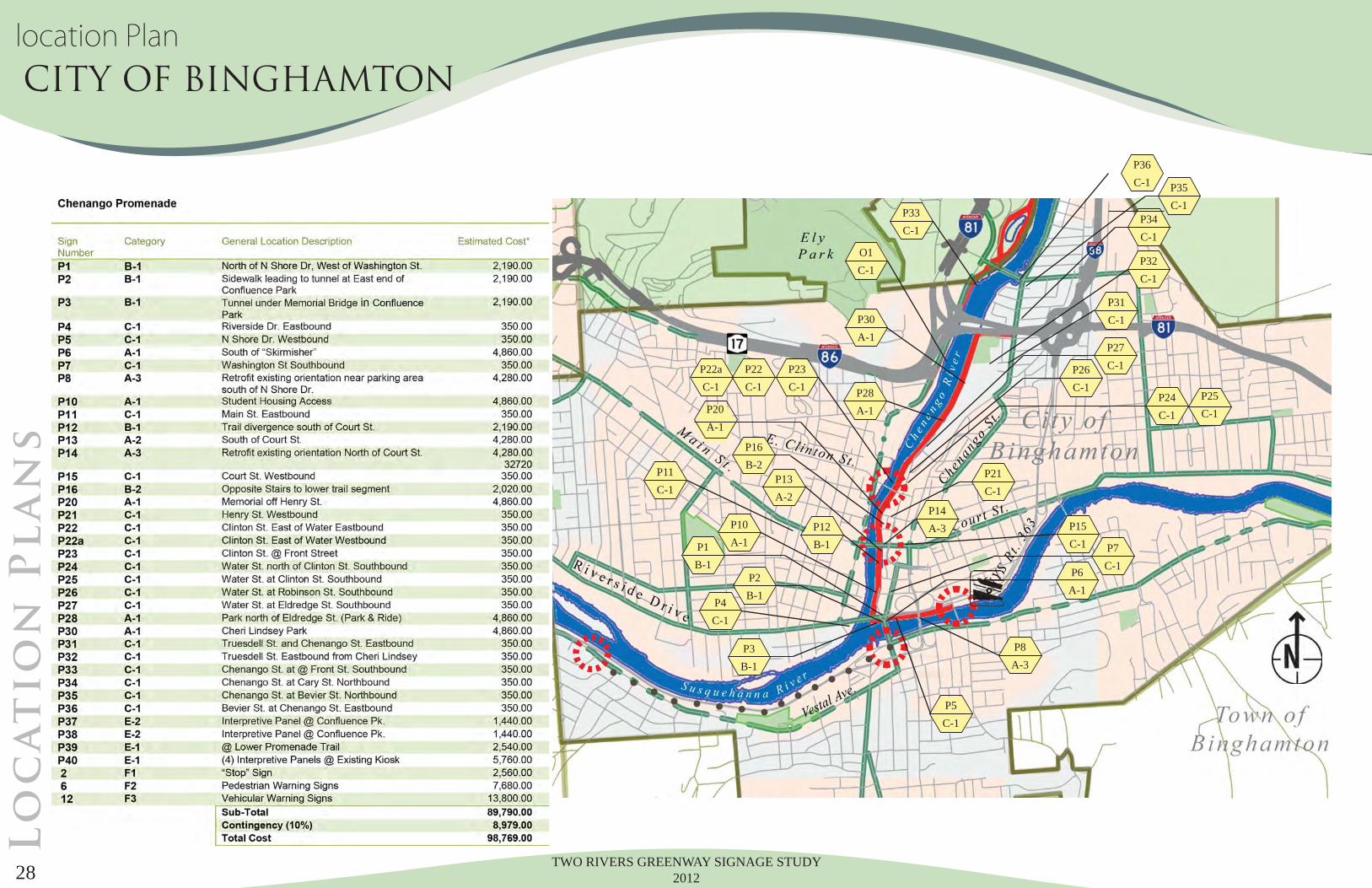
location Plan CITY OF BINGHAMTONL
oc
at
io
n P
la
ns
TWO RIVERS GREENWAY SIGNAGE STUDY 2012 29
B5B-1 B6
B-1
B7A-1
B8C-1
B9C-1
B10C-1
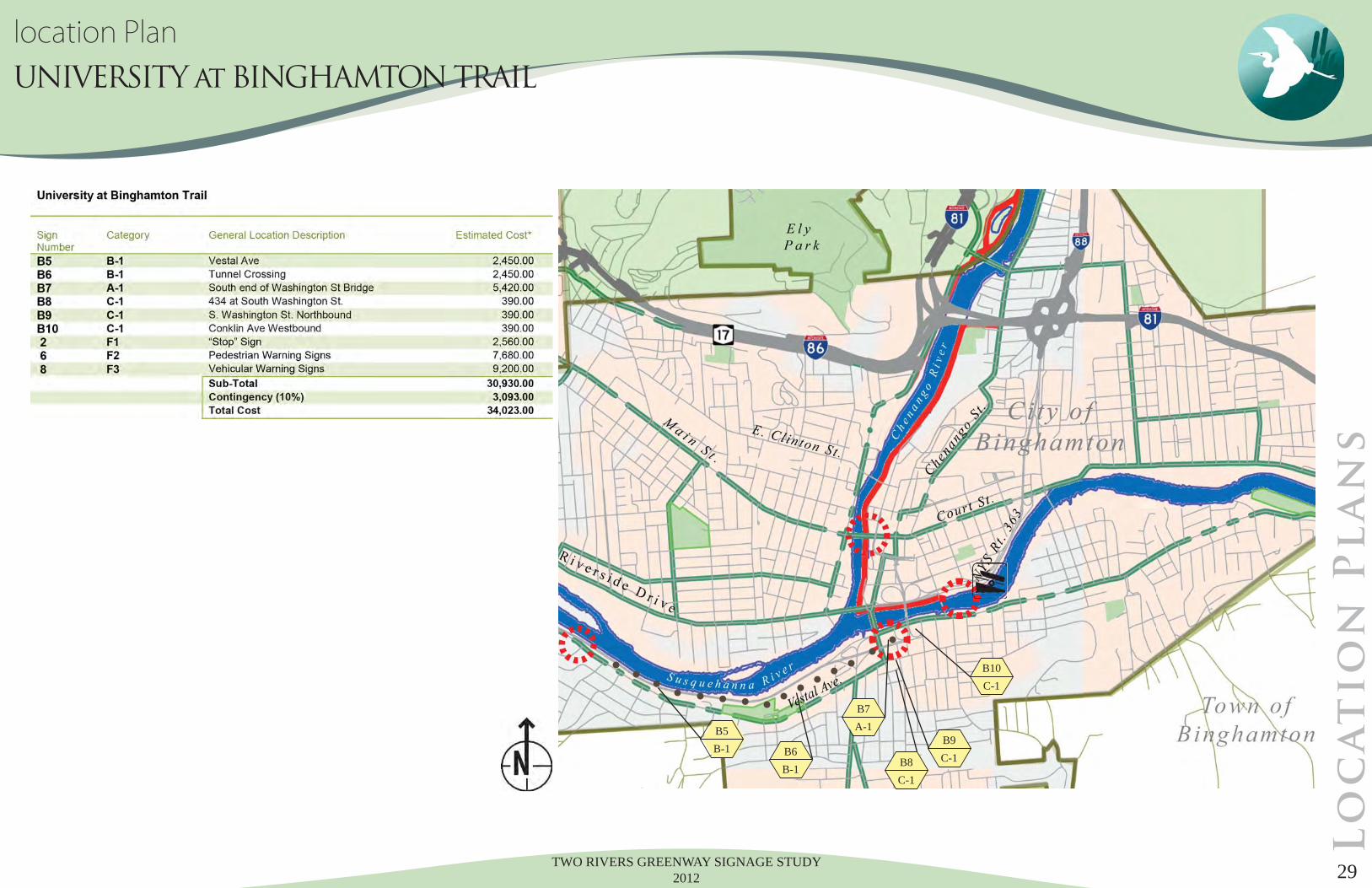
location Plan UNIVERSITY at BINGHAMTON TRAIL
Lo
ca
tio
n P
la
ns
TWO RIVERS GREENWAY SIGNAGE STUDY 2012 30
O2C-1
O3C-1
O4B-1
O19C-1
O5C-1
O10B-1
O11A-1
O12A-1
O21C-2
O23A-1
O21E-1
O20E-1
O17A-1
O13C-1
O14C-1
O15C-1
O16C-1
O20C-2
O25C-2
O24C-2
O22D-1
O26C-2
O27C-2
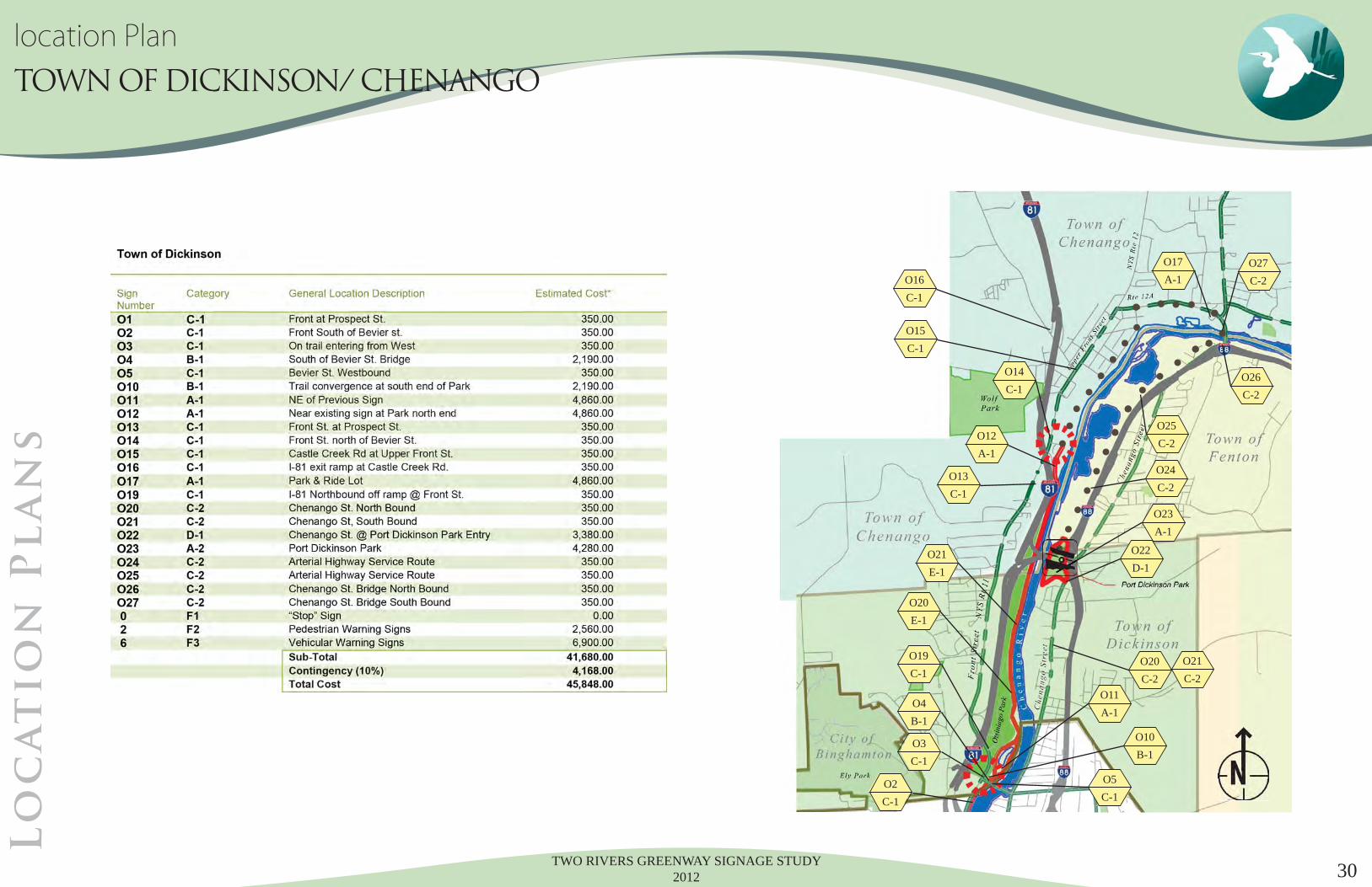
location Plan TOWN OF DICKINSON/ CHENANGO
Lo
ca
tio
n P
la
ns
TWO RIVERS GREENWAY SIGNAGE STUDY 201231
C1C-1
C2C-1
C3C-1
C5C-1
C4D-1
C6A-1
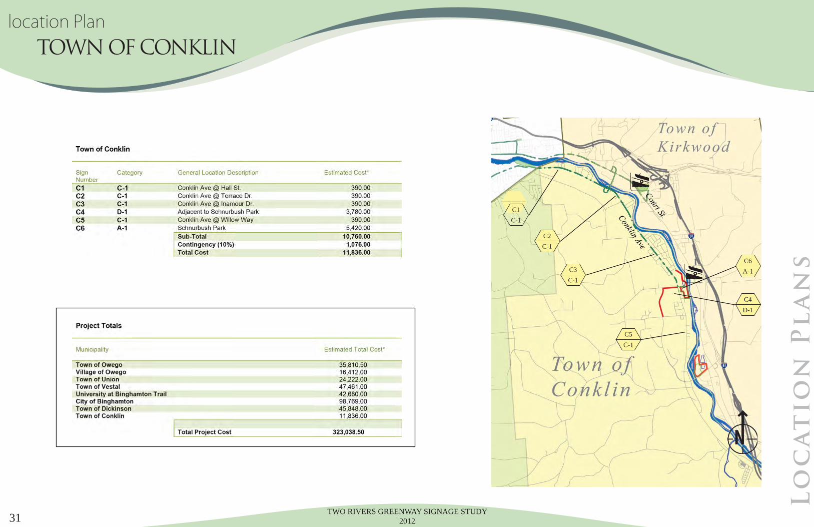
location Plan TOWN OF CONKLIN
Lo
ca
tio
n P
la
ns
TWO RIVERS GREENWAY SIGNAGE STUDY 201232
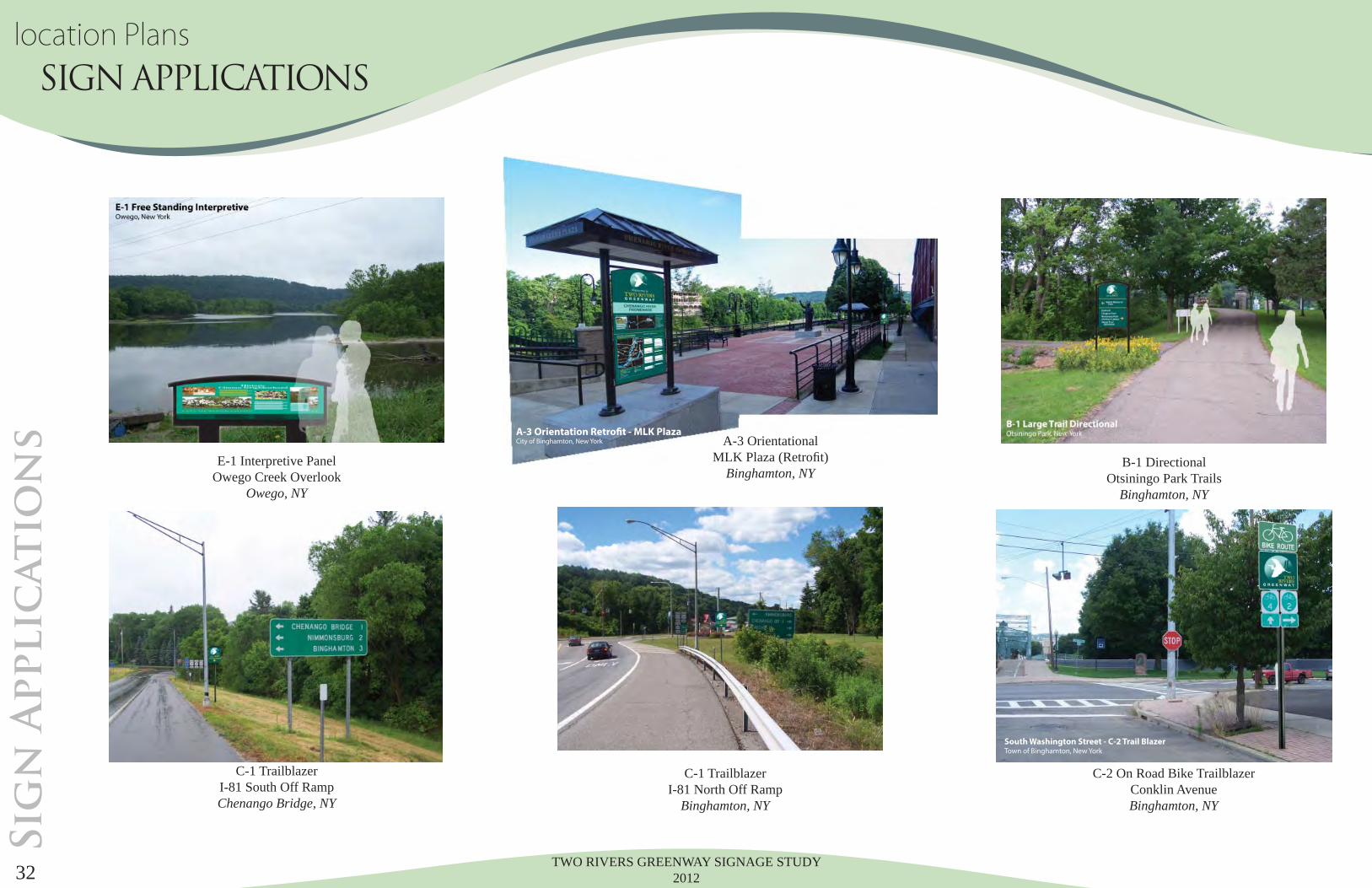
A-3 Orientation Retrofit - MLK PlazaCity of Binghamton, New York
E-1 Interpretive Panel Owego Creek Overlook
Owego, NY
B-1 DirectionalOtsiningo Park Trails
Binghamton, NY
A-3 OrientationalMLK Plaza (Retrofi t)
Binghamton, NY
C-1 Trailblazer I-81 South Off Ramp Chenango Bridge, NY
C-2 On Road Bike Trailblazer Conklin Avenue Binghamton, NY
C-1 Trailblazer I-81 North Off Ramp
Binghamton, NY
Sig
n A
pplic
at
io
ns
South Washington Street - C-2 Trail BlazerTown of Binghamton, New York
location Plans SIGN APPLICATIONS
TWO RIVERS GREENWAY SIGNAGE STUDY 2012 33
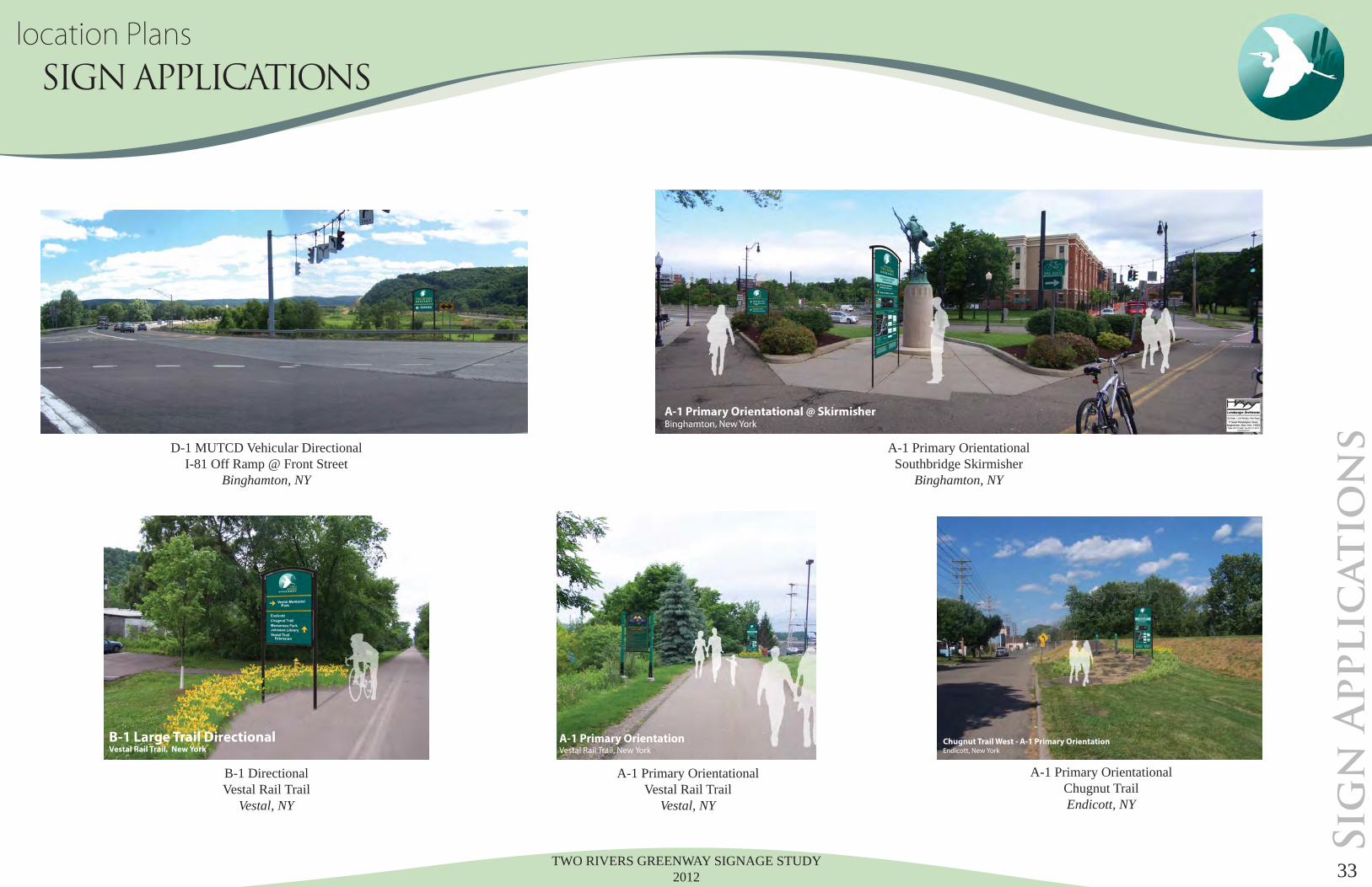
B-1 DirectionalVestal Rail Trail
Vestal, NY
A-1 Primary OrientationalVestal Rail Trail
Vestal, NY
D-1 MUTCD Vehicular DirectionalI-81 Off Ramp @ Front Street
Binghamton, NY
A-1 Primary OrientationalChugnut TrailEndicott, NY
A-1 Primary OrientationalSouthbridge Skirmisher
Binghamton, NY
Sig
n A
pplic
at
io
ns
Chugnut Trail West - A-1 Primary OrientationEndicott, New York
B-1 Large Trail DirectionalVestal Rail Trail, New York
A-1 Primary OrientationVestal Rail Trail, New York
location Plans SIGN APPLICATIONS

TWO RIVERS GREENWAY SIGNAGE STUDY 201234
REGULATORY SIGNS, WARNING SIGNS AND PAVEMENT MARKINGS
Each of the “Challenge Areas” identifi ed along portions of the Two Rivers Greenway will be inventoried to identify the exist-ing regulatory and warning signs, including pavement markings, as they pertain to pedestrian and bicycle crossings, and their interface with public highways. The inventory will be reviewed for compliance with the Manual on Uniform Traffi c Control Devices (MUTCD) and associated documents referenced below. Recommendations will be made for correction, if necessary, including possible modifi cations or improvements to the type, size, location and placement of the signs or pavement markings.
The following documents will be used to establish compliance for the appropriate type, size and placement of signs and pave-ment markings at the specifi c “Challenge Areas” of the Two Rivers Greenway:The Federal Highway Administration’s Manual on Uniform Traffi c Control Devices (MUTCD), 2009 Edition dated May 2012 including Revisions 1 and 2, predominately:
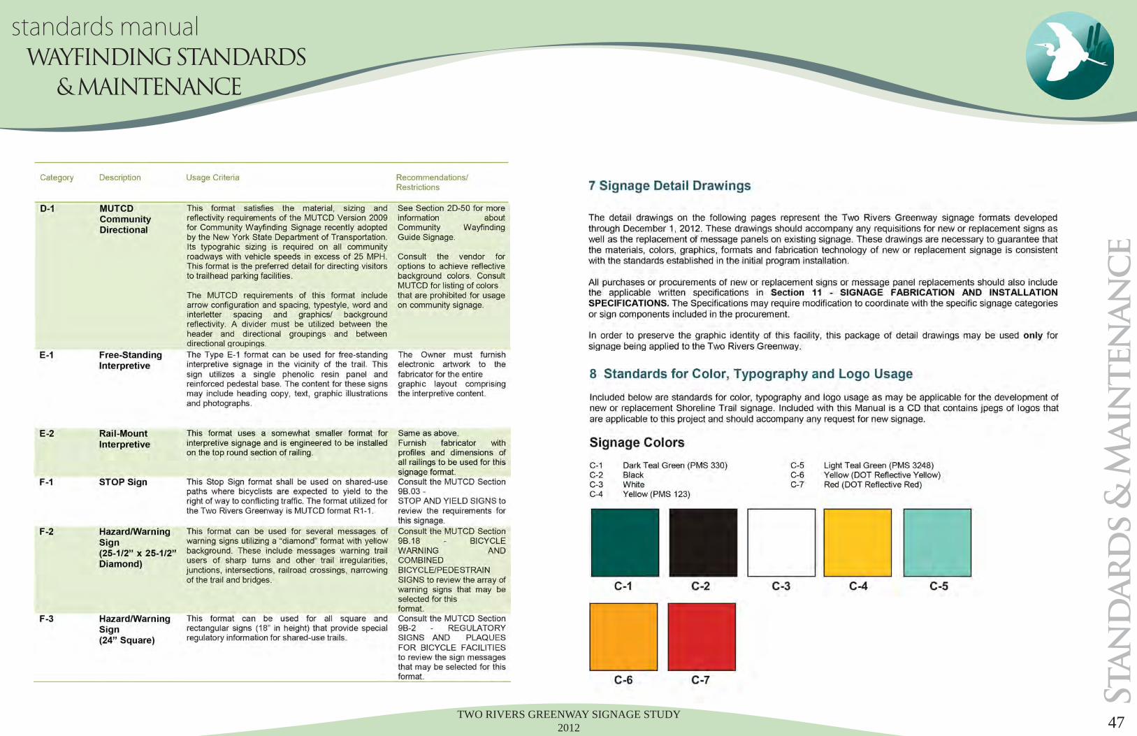
• Part 2A – General • Part 2B – Regulatory Signs • Part 2C – Warning Signs • Part 3 – Pavement Markings • Part 9 – Traffi c Control for Bicycle Facilities
The N.Y.S. Department of Transportation’s (NYSDOT) Supplement to the MUTCD, dated March 16, 2012, with Parts corre-sponding to those referenced from the MUTCD above
The NYSDOT’s Standard Sheets (US Customary), primarily:
• Series 645 – Signs • Series 685 - Pavement Markings
The NYSDOT Highway Design Manual , Chapter 11 -Signs, Signals, and Delineation, including Appendix A – The NYS Scenic Byways Sign Manual.
Sig
n &
Pavem
en
t r
eg
ulatio
ns
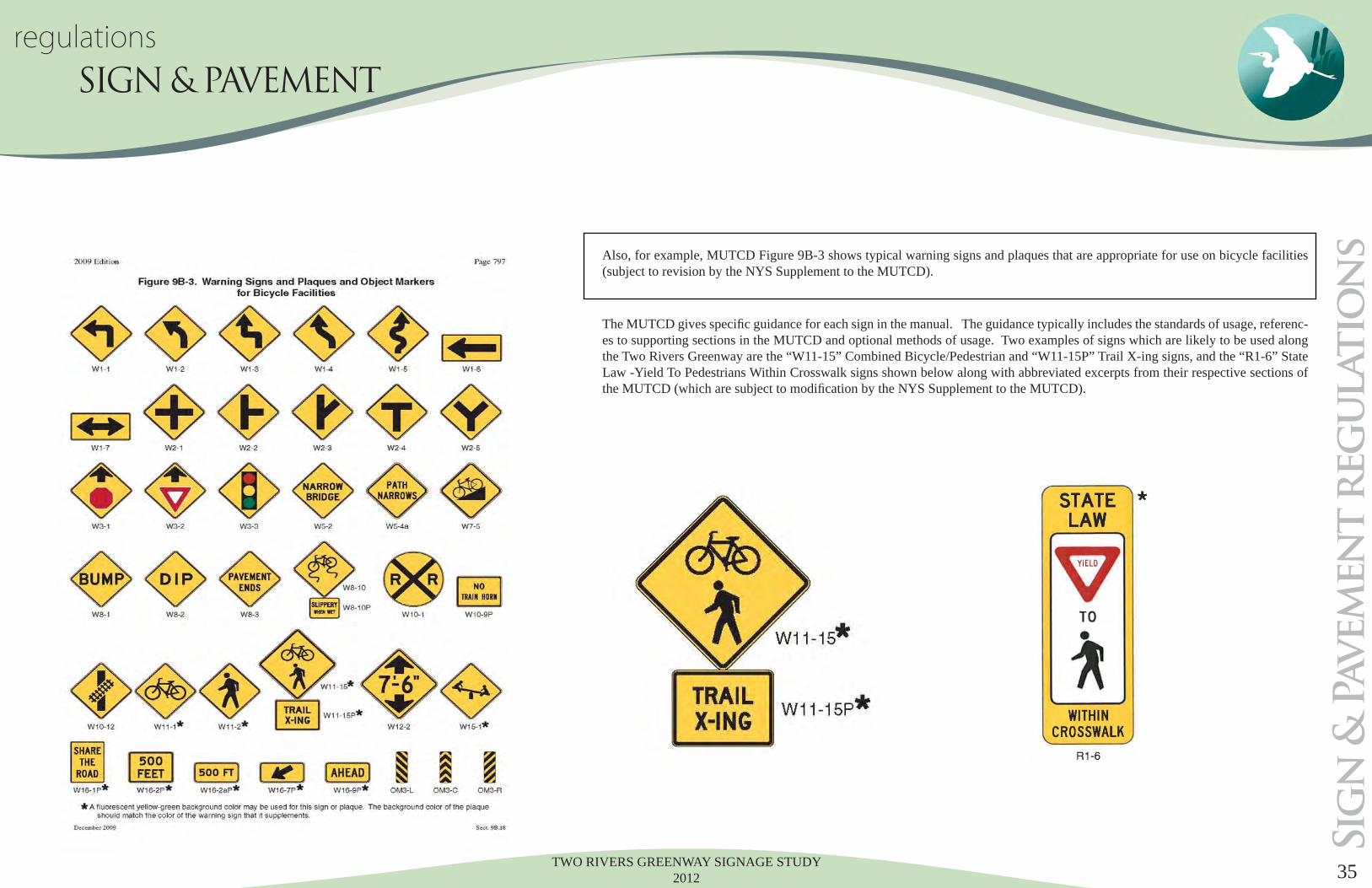
For example, MUTCD Figure 2A-2 shows placement heights and lateral locations for various sign installations.
regulations SIGN & PAVEMENT
TWO RIVERS GREENWAY SIGNAGE STUDY 2012 35
Also, for example, MUTCD Figure 9B-3 shows typical warning signs and plaques that are appropriate for use on bicycle facilities (subject to revision by the NYS Supplement to the MUTCD).
The MUTCD gives specifi c guidance for each sign in the manual. The guidance typically includes the standards of usage, referenc-es to supporting sections in the MUTCD and optional methods of usage. Two examples of signs which are likely to be used along the Two Rivers Greenway are the “W11-15” Combined Bicycle/Pedestrian and “W11-15P” Trail X-ing signs, and the “R1-6” State Law -Yield To Pedestrians Within Crosswalk signs shown below along with abbreviated excerpts from their respective sections of the MUTCD (which are subject to modifi cation by the NYS Supplement to the MUTCD).
Sig
n &
Pavem
en
t r
eg
ulatio
ns
regulationsSIGN & PAVEMENT
TWO RIVERS GREENWAY SIGNAGE STUDY 201236
regulations SIGN & PAVEMENT
BMTS Greenway Sign Study Project #CA9-295Challenging Areas Sign and Pavement Marking Recommendations
NY17C at Hickories Park (RR Underpass), Town of Owego
o Install L or LS style crosswalk across NY17C
o Install advance W11-2 Pedestrian Crossing warning signs with W16-2aP “300 FEET” supplemen-tal warning plaques on NY17C
o Install W11-2 Pedestrian warning signs with W16-7P diagonal down arrow supplemental plaques on NY17C at the crosswalk
o Install two sets of double-posted R5-3 “No Motor Vehicles” signs at the trail entrance (near the bollards) and at the RR underpass*
o Install an R1-1 Stop sign with solid white stop bar pavement marking on the trail at the intersec-tion with NY17C*
o Install a W2-4 Intersection warning sign with a supplemental W16-8P “RTE 17C” plaque on the trail approximately 100 feet prior to Route 17C,
o Option: Install three bollards with solid yellow obstruction pavement markings on south side of NY17C at the trail intersection (center bollard removable for EV and MV access).*
* Assumes the trail will be paved.
NY17C (Main St.) at Canal Street, Village of Owego
o Install L or LS style crosswalk across NY17C on the east side of Canal Street**
o Install advance W11-2 Pedestrian Crossing warning signs with W16-2aP “200 FEET” supplemen-tal warning plaques on NY17C
o Install W11-2 Pedestrian warning signs with W16-7P diagonal down arrow supplemental plaques on NY17C at the crosswalk
** Consider installation of ADA curb ramp on the southeast corner of the intersection with a connection to sidewalk on the south side of Route 17C.
NY434 at Marshland Road (West), Town of Owego
o Install W11-1Bicycle warnings signs with supplemental W16-2aP “500 FEET” plaques on NY17C in advance of Marshland Road
o Install bicycle lane arrows and symbols in the bicycle lanes (shoulders) on NY17C approximately 200 feet in advance of Marshland Road
o Install W11-1 Bicycle warning signs with supplemental W16-1P “SHARE THE ROAD” plaques on the east side of Marshland Road between NY434 and the NY17 overpass
Vestal Avenue at Riverview Terrace, Village of Endicott
o Change the crosswalks to L or LS style crosswalk across Vestal Avenue along the north side of the Riverview Terrace intersection with ADA curb ramps
o Install an advance W11-2 Pedestrian Crossing warning signs with a W16-2aP “200 FEET” supple-mental warning plaques on Vestal Avenue in the southbound direction
o Install an overhead R1-9 “STATE LAW – YIELD TO PEDESTRIANS” in the northbound direction on Vestal Avenue approximately 200 feet prior to the intersection (installed overhead on the bridge truss)
o Install W11-2 Pedestrian warning signs with W16-7P diagonal down arrow supplemental plaques on Vestal Avenue at the crosswalk
o Install in-roadway R1-6 “STATE LAW - YIELD TO PEDESTRIANS IN CROSSWALK” signs on Vestal Avenue in advance of the crosswalk
o Narrow the through lanes of Vestal Avenue – particularly in the southbound direction – with the use of white edgelines and cross-hatching
East Clinton Street at Water Street, City of Binghamton
o Re-install bicycle detection markings on the approaches to the signal
o Install bicycle lane arrows and symbols within all bike lanes. They should be installed in the imme-diate vicinity of the intersection and approximately 200 feet from the intersection
o Install a W11-1 bicycle warning sign with a supplemental W16-1P “SHARE THE ROADWAY” sign on East Clinton Street prior to the end of the eastbound bicycle lane,
o Re-install S-type crosswalks at the signalized intersection
Sig
n &
Pavem
en
t r
eg
ulatio
ns
TWO RIVERS GREENWAY SIGNAGE STUDY 2012 37
regulationsSIGN & PAVEMENT
o Install solid white edgelines to delineate the bicycle lane on Water St. along the section where it is located in the wide snow storage area
o Install double-posted R9-3bP “USE CROSSWALK (with right arrow) signs at the end of the Promenade where it intersects East Clinton Street
o Consider upgrading the pedestrian signal indications at the intersection to include countdown timers along with the associated R10-3e traffi c signal pedestrian actuation signs (the crosswalk across East Clinton St. on the west side of Water St. currently has pedestrian signal indications with countdown timers)
o Install an R10-15 “TURNING VEHICLES YIELD TO PEDESTRIANS” sign at the intersection on the southbound approach of Water Street
US11 (Front Street) at Bevier Street, City of Binghamton
o Install R10-15 “TURNING VEHICLES YIELD TO PEDESTRIANS” signs at the intersection on the US11 northbound and Bevier St. approaches
o Change the crosswalks to Type L or LS style crosswalk across Bevier Street
o Replace the existing pedestrian actuation signs with R10-3e signs
o Install a W11-15 Bicycle & Pedestrian warning sign with a W16-2aP “500 FEET” supplemental plaque on the US11 southbound approach to the signal
o Install a stop bar across the shared use path (from Old Front Street) at the edge of shoulder of US11
Front Street (US11) at Otsiningo Park North Access, Town of Chenango
o Install W11-15 Bicycle & Pedestrian warning signs with a W16-2aP “300 FEET” supplemental plaques on Front Street (US11) in advance of the park entrance
o Change the crosswalks to L or LS style crosswalks
o At the adjacent signalized intersection of Front Street (US11) and Exit 6 I-81 North:
o Install L or LS style crosswalks
o Install R10-3e traffi c signal pedestrian actuations signs
o Install an R10-15 “TURNING VEHICLES YIELD TO PEDESTRIANS” sign at the end of the I-81 Exit 6 exit ramp
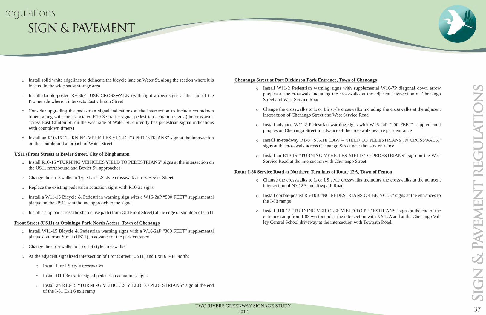
Chenango Street at Port Dickinson Park Entrance, Town of Chenango
o Install W11-2 Pedestrian warning signs with supplemental W16-7P diagonal down arrow plaques at the crosswalk including the crosswalks at the adjacent intersection of Chenango Street and West Service Road
o Change the crosswalks to L or LS style crosswalks including the crosswalks at the adjacent intersection of Chenango Street and West Service Road
o Install advance W11-2 Pedestrian warning signs with W16-2aP “200 FEET” supplemental plaques on Chenango Street in advance of the crosswalk near re park entrance
o Install in-roadway R1-6 “STATE LAW – YIELD TO PEDESTRIANS IN CROSSWALK” signs at the crosswalk across Chenango Street near the park entrance
o Install an R10-15 “TURNING VEHICLES YIELD TO PEDESTRIANS” sign on the West Service Road at the intersection with Chenango Street
Route I-88 Service Road at Northern Terminus of Route 12A, Town of Fenton
o Change the crosswalks to L or LS style crosswalks including the crosswalks at the adjacent intersection of NY12A and Towpath Road
o Install double-posted R5-10B “NO PEDESTRIANS OR BICYCLE” signs at the entrances to the I-88 ramps
o Install R10-15 “TURNING VEHICLES YIELD TO PEDESTRIANS” signs at the end of the entrance ramp from I-88 westbound at the intersection with NY12A and at the Chenango Val-ley Central School driveway at the intersection with Towpath Road.
Sig
n &
Pavem
en
t r
eg
ulatio
ns
TWO RIVERS GREENWAY SIGNAGE STUDY 201238
JO-ANNE FABRICS PARKING LOT
CALIFORNIA GRILL PARKING LOT
VESTAL RAIL TRAIL
VESTAL PARKWAY STATE Rt 434VESTAL PARKWAY STATE Rt 434
AIRBO
RN
E DR
IVE
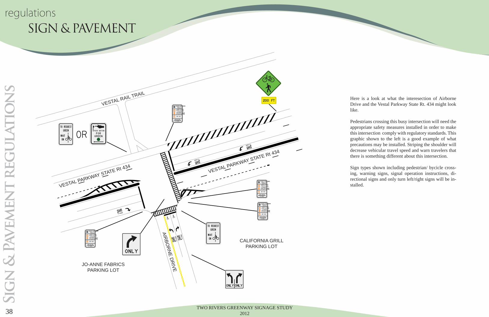
Here is a look at what the interesection of Airborne Drive and the Vestal Parkway State Rt. 434 might look like.
Pedestrians crossing this busy intersection will need the appropriate safety measures installed in order to make this intersection comply with regulatory standards. This graphic shown to the left is a good example of what precautions may be installed. Striping the shoulder will decrease vehicular travel speed and warn travelers that there is something different about this intersection.
Sign types shown including pedestrian/ bycicle cross-ing, warning signs, signal operation instructions, di-rectional signs and only turn left/right signs will be in-stalled.
Sig
n &
Pavem
en
t r
eg
ulatio
ns
regulations SIGN & PAVEMENT
TWO RIVERS GREENWAY SIGNAGE STUDY 2012 39
regulationsSIGN & PAVEMENT
CH
ENAN
GO
RIV
ER
CH
ENAN
GO
RIV
ER
LOW
ER T
RAIL
LOW
ER T
RAIL
COURT STREET BRIDGE
COURT STREET
CH
ENA
NG
O R
IVER
PRO
MEN
AD
E
CH
ENA
NG
O R
IVER
PRO
MEN
AD
E
M.L.K PLAZA
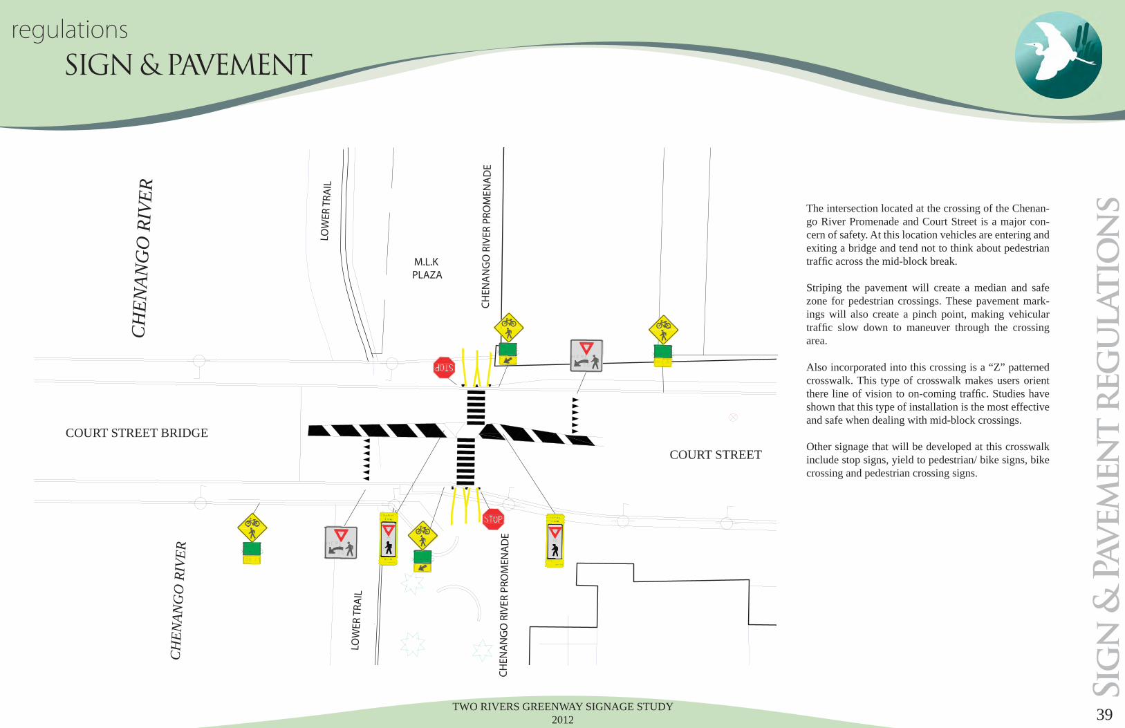
The intersection located at the crossing of the Chenan-go River Promenade and Court Street is a major con-cern of safety. At this location vehicles are entering and exiting a bridge and tend not to think about pedestrian traffi c across the mid-block break.
Striping the pavement will create a median and safe zone for pedestrian crossings. These pavement mark-ings will also create a pinch point, making vehicular traffi c slow down to maneuver through the crossing area.
Also incorporated into this crossing is a “Z” patterned crosswalk. This type of crosswalk makes users orient there line of vision to on-coming traffi c. Studies have shown that this type of installation is the most effective and safe when dealing with mid-block crossings.
Other signage that will be developed at this crosswalk include stop signs, yield to pedestrian/ bike signs, bike crossing and pedestrian crossing signs.
Sig
n &
Pavem
en
t r
eg
ulatio
ns

TWO RIVERS GREENWAY SIGNAGE STUDY 201240
Stan
dar
ds &
Main
ten
an
ce
standards manual WAYFINDING STANDARDS & MAINTENANCE

TWO RIVERS GREENWAY SIGNAGE STUDY 2012 41
Stan
dar
ds &
Main
ten
an
ce
standards manual WAYFINDING STANDARDS & MAINTENANCE
TWO RIVERS GREENWAY SIGNAGE STUDY 201242
standards manual WAYFINDING STANDARDS & MAINTENANCE
Stan
dar
ds &
Main
ten
an
ce

TWO RIVERS GREENWAY SIGNAGE STUDY 2012 43
Stan
dar
ds &
Main
ten
an
ce
standards manual WAYFINDING STANDARDS & MAINTENANCE

TWO RIVERS GREENWAY SIGNAGE STUDY 201244
Stan
dar
ds &
Main
ten
an
ce
standards manual WAYFINDING STANDARDS & MAINTENANCE
TWO RIVERS GREENWAY SIGNAGE STUDY 2012 45
Stan
dar
ds &
Main
ten
an
ce
standards manual WAYFINDING STANDARDS & MAINTENANCE
TWO RIVERS GREENWAY SIGNAGE STUDY 201246
Stan
dar
ds &
Main
ten
an
ce
standards manual WAYFINDING STANDARDS & MAINTENANCE
TWO RIVERS GREENWAY SIGNAGE STUDY 2012 47
Stan
dar
ds &
Main
ten
an
ce
standards manual WAYFINDING STANDARDS & MAINTENANCE
TWO RIVERS GREENWAY SIGNAGE STUDY 201248
Stan
dar
ds &
Main
ten
an
ce
standards manual WAYFINDING STANDARDS & MAINTENANCE

TWO RIVERS GREENWAY SIGNAGE STUDY 2012 49
...End of Section
Stan
dar
ds &
Main
ten
an
ce
standards manual WAYFINDING STANDARDS & MAINTENANCE
TWO RIVERS GREENWAY SIGNAGE STUDY 201250
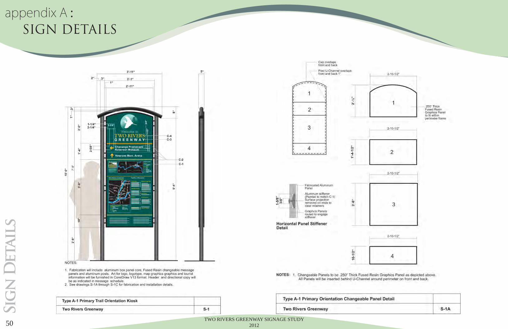
Sig
n D
etail
sappendix A : SIGN DETAILS
TWO RIVERS GREENWAY SIGNAGE STUDY 2012 51
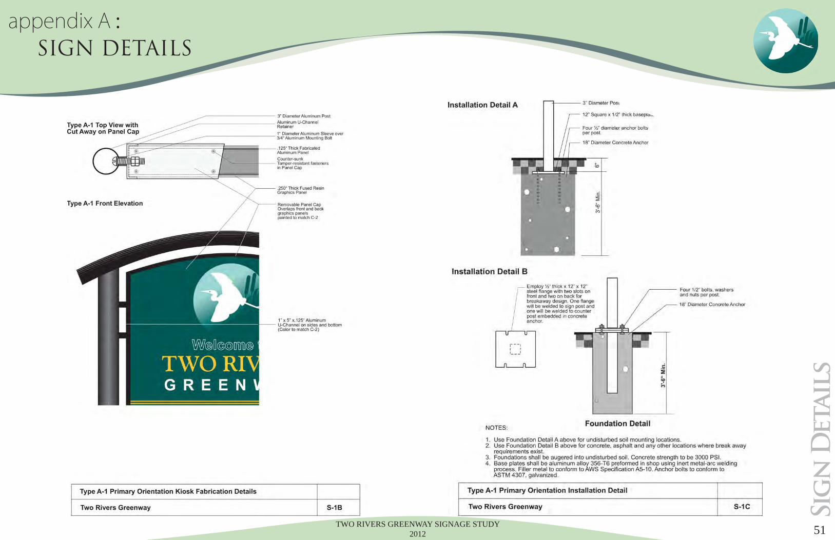
Sig
n D
etail
s
appendix A : SIGN DETAILS

TWO RIVERS GREENWAY SIGNAGE STUDY 201252
Sig
n D
etail
sappendix A : SIGN DETAILS
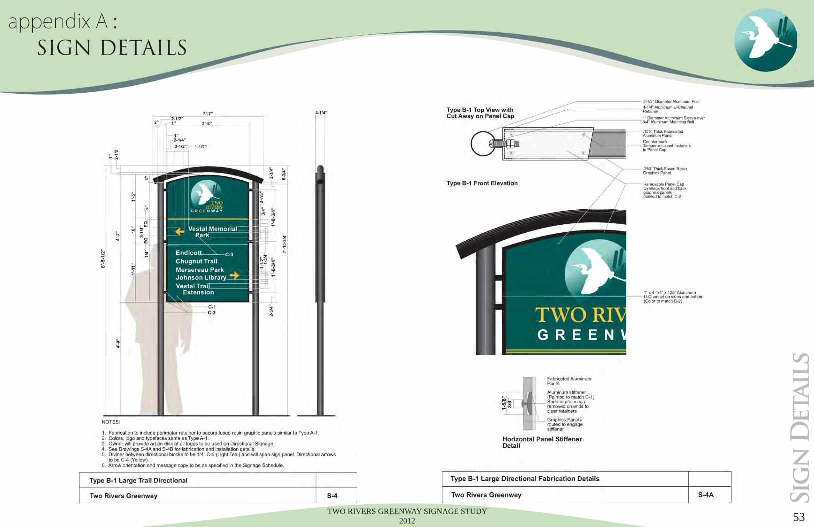
TWO RIVERS GREENWAY SIGNAGE STUDY 2012 53
Sig
n D
etail
s
appendix A : SIGN DETAILS
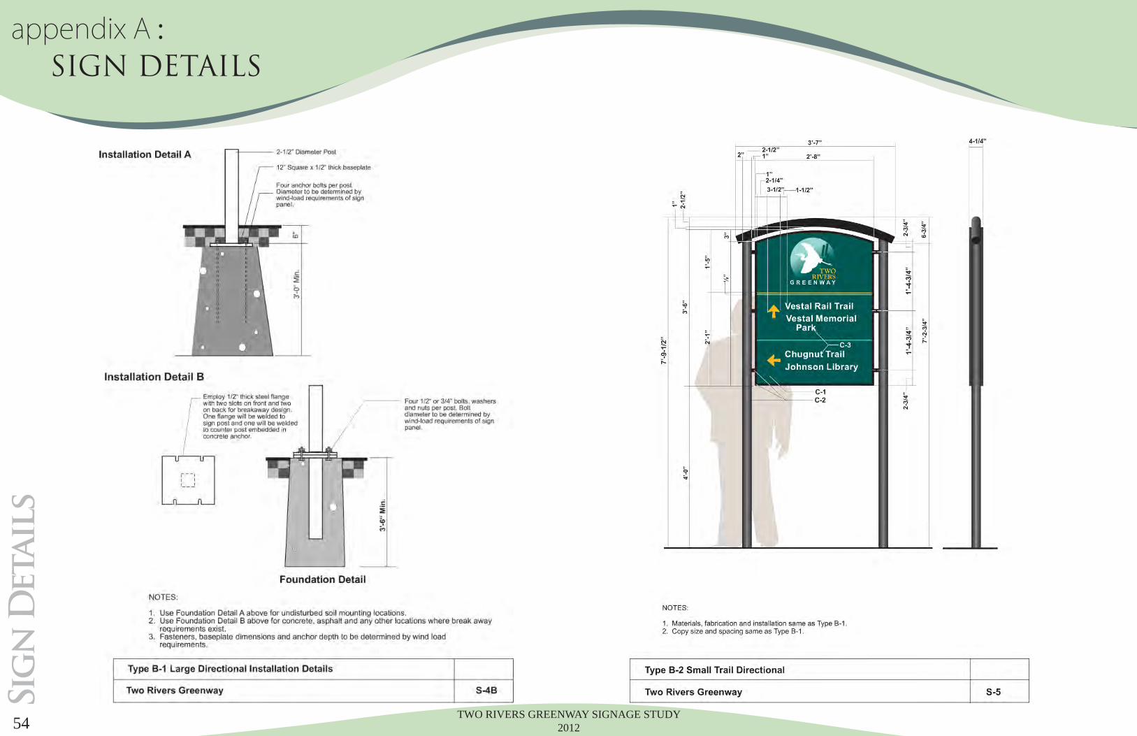
TWO RIVERS GREENWAY SIGNAGE STUDY 201254
Sig
n D
etail
sappendix A : SIGN DETAILS
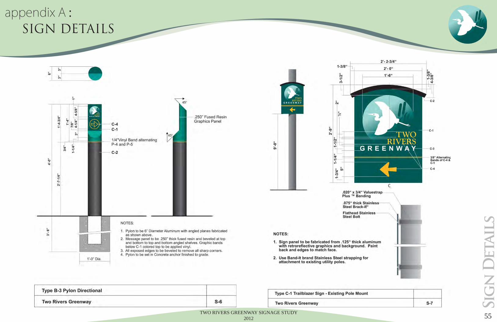
TWO RIVERS GREENWAY SIGNAGE STUDY 2012 55
Sig
n D
etail
s
appendix A : SIGN DETAILS
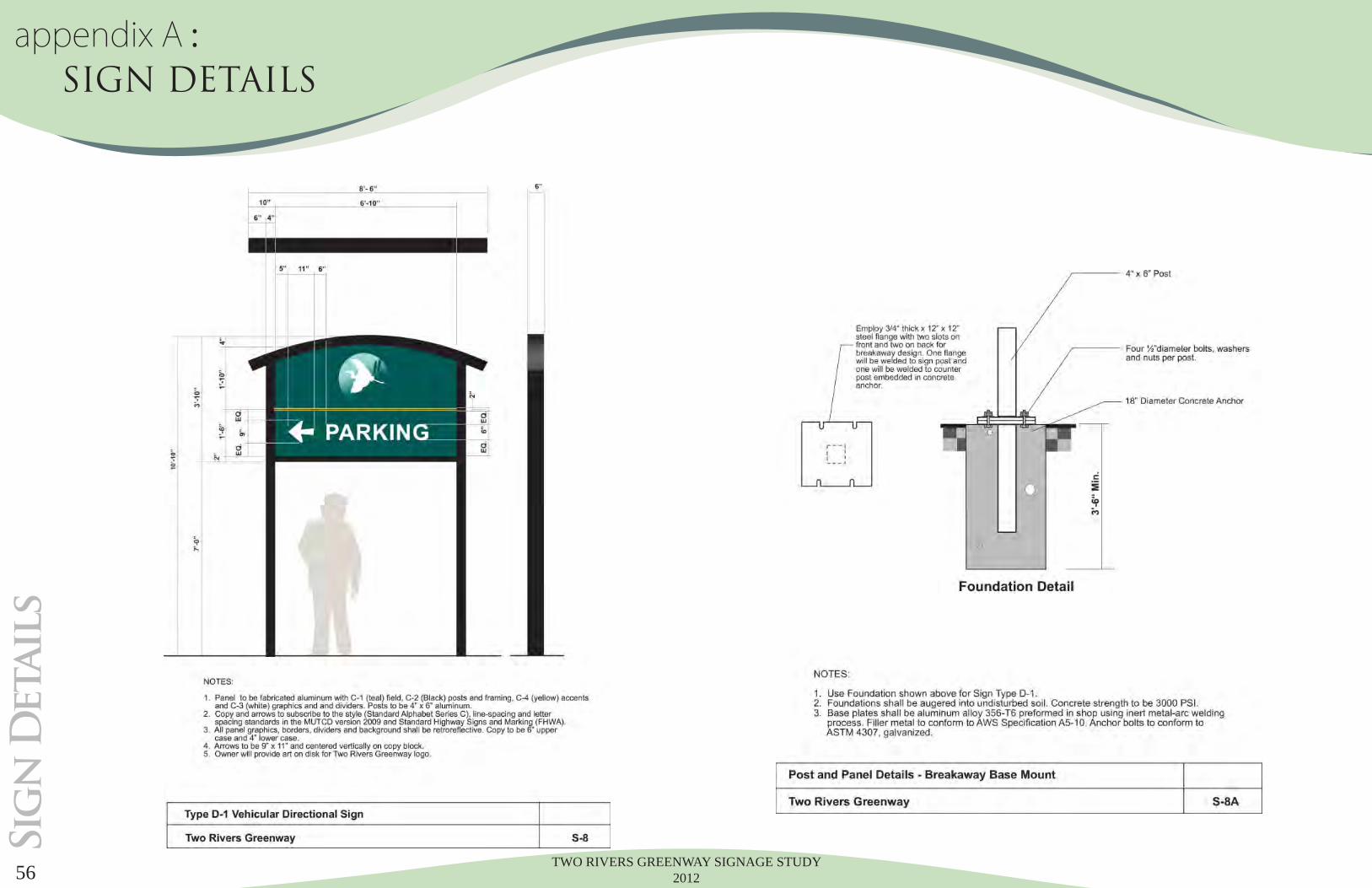
TWO RIVERS GREENWAY SIGNAGE STUDY 201256
Sig
n D
etail
sappendix A : SIGN DETAILS

TWO RIVERS GREENWAY SIGNAGE STUDY 2012 57
Sig
n D
etail
s
appendix A : SIGN DETAILS
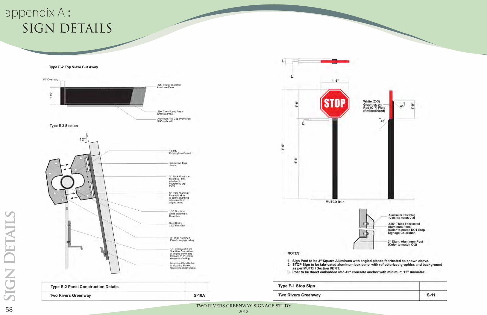
TWO RIVERS GREENWAY SIGNAGE STUDY 201258
Sig
n D
etail
sappendix A : SIGN DETAILS
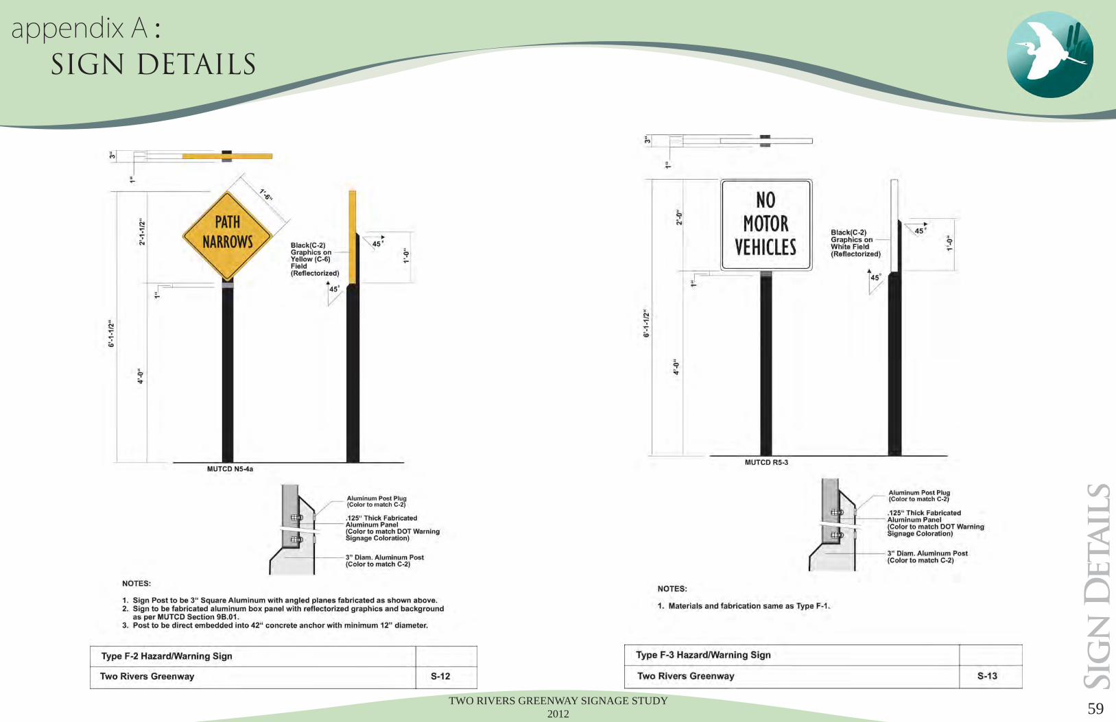
TWO RIVERS GREENWAY SIGNAGE STUDY 2012 59
Sig
n D
etail
s
appendix A : SIGN DETAILS
TWO RIVERS GREENWAY SIGNAGE STUDY 201260
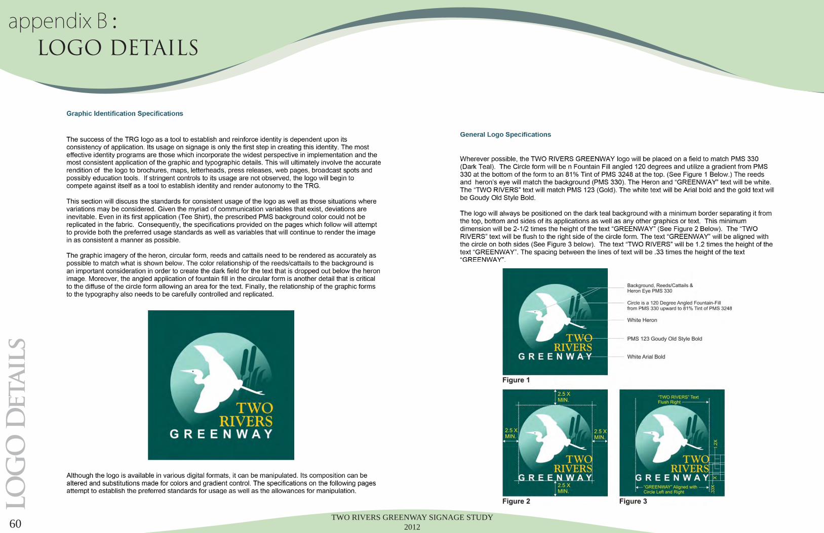
LO
GO
Detail
sappendix B : LOGO DETAILS

TWO RIVERS GREENWAY SIGNAGE STUDY 2012 61
LO
GO
Detail
s
...End of Section
appendix B : LOGO DETAILS

TWO RIVERS GREENWAY SIGNAGE STUDY 201262
Co
nstr
uc
tio
n S
pec
sappendix C : Construction Specs
TWO RIVERS GREENWAY SIGNAGE STUDY 2012 63
Co
nstr
uc
tio
n S
pec
s
appendix C : Construction Specs
TWO RIVERS GREENWAY SIGNAGE STUDY 201264
Co
nstr
uc
tio
n S
pec
sappendix C : Construction Specs

TWO RIVERS GREENWAY SIGNAGE STUDY 2012 65
Co
nstr
uc
tio
n S
pec
s
...End of Section
appendix C : Construction Specs
TWO RIVERS GREENWAY SIGNAGE STUDY 201266
Co
nstr
uc
tio
n S
pec
sappendix C : Construction Specs

TWO RIVERS GREENWAY SIGNAGE STUDY 2012 67
Co
nstr
uc
tio
n S
pec
s
appendix C : Construction Specs
...End of Section

TWO RIVERS GREENWAY SIGNAGE STUDY 2012