Embed Size (px)
Citation preview
Geologic Resources Inventory Scoping Summary Tule Springs Fossil Beds National Monument, Nevada
Prepared by Rebecca Port October 16, 2015
Geologic Resources Division National Park Service US Department of the Interior
The Geologic Resources Inventory (GRI) is one of 12 natural resource inventories within the National Park Service (NPS). The Geologic Resources Division (GRD) of the NPS administers the inventory. The GRI provides each of the 270 identified natural area National Park System units with, first, a geologic scoping meeting and summary (this document), followed by a digital geologic map, and lastly a GRI report. The purpose of GRI scoping meetings is to 1) evaluate the adequacy of existing geologic maps for resource management, 2) discuss distinctive geologic features and processes, and park-specific geologic management issues, and 3) identify geologic monitoring and research needs. If possible, the scoping meeting also includes a site visit with local experts. Tule Springs Fossil Beds National Monument is a newly established (December 2014) monument and therefore is not one of the “original 270” units. As of August 2015, how the monument will be addressed by the Inventory and Monitoring Program, as well as what GRI products will ultimately be produced for it, remains to be determined. The NPS held a GRI scoping meeting for Tule Springs Fossil Beds National Monument which included a discussion on 14 July 2015, held at Lake Mead National Recreation Area near Boulder City, Nevada followed by a site visit on 15 July 2015. Participants included NPS staff from GRD, the national monument, Lake Mead National Recreation Area, and Mojave Desert Inventory and Monitoring Network; NPS interns from the Geoscientists-in-the-Parks program; and cooperators from the US Geological Survey (USGS), San Bernardino County Museum (SBCM), Nevada Bureau of Mines and Geology/University of Nevada, Reno, University of Nevada, Las Vegas, and Montana State University (table 1). To begin the discussion portion of the scoping meeting, Jason Kenworthy (GRD, GRI report coordinator) welcomed the group and gave an overview of the GRI program. The monument’s acting superintendent, Vincent Santucci, discussed the history of NPS paleontology and current laws and regulations. Eric Scott (SBCM, paleontologist) described the fossil assemblage of Tule Springs and told the story of the monument’s establishment. Kathleen Springer (USGS, geologist) provided an overview of the geologic framework of the Tule Springs Fossil Beds area in order to put into perspective the importance and significance of not just the fossils but their geologic context (Springer et al. 2015). Tim Connors (GRD, GRI map coordinator) shared a recorded webinar explaining the GRI digital map products and facilitated the discussion and assessment of map coverage and needs. Jason Kenworthy then led the discussion regarding geologic features, processes, and issues, and monitoring and research needs. A site visit was held the following day in which scoping meeting participants visited the North and South units of Tule Springs Fossil Beds National Monument. The monument does not contain any infrastructure at this time (e.g., roads, walkways) and only two recently installed signs (fig. 1) mark the entrance to the monument. Kathleen Springer, assisted by Craig Manker, Jeff Pigati, and Vincent Santucci, led the site visit through the monument along unmarked, 4-wheel drive paths. During the site visit, trip leaders pointed out examples of geologic features, processes, and issues that had been identified during the discussion the previous day.
1

This scoping summary highlights discussions that occurred during the GRI scoping meeting for Tule Springs Fossil Beds National Monument and includes the following sections: • Park and Geologic Setting and Significance • Geologic Mapping for Tule Springs Fossil Beds National Monument • Geologic Features, Processes, and Issues • Literature Cited
Table 1. Scoping meeting participants
Name Affiliation Position
Tim Connors NPS Geologic Resources Division Geologist Jason Kenworthy NPS Geologic Resources Division Geologist
Rebecca Port NPS Geologic Resources Division Technical Writer/Geologist
Vincent L. Santucci NPS Tule Springs Fossil Beds National Monument Acting Superintendent
David Gundlach NPS Mojave Desert I&M Network GIS Specialist Ryan Hodge NPS Mojave Desert I&M Network Data Management Mark Lehman NPS Mojave Desert I&M Network Data Manager Nita Tallent NPS Mojave Desert I&M Network Program Manager Kerry Gaiz NPS Lake Mead National Recreation Area GIS Specialist
Aubrey Bonde NPS Geoscientists-in-the-Parks (UNLV) Intern Fabian Hardy NPS Geoscientists-in-the-Parks (UNLV) Intern Craig Manker USGS Geologist
Jeff Pigati USGS Geologist Kathleen Springer USGS Geologist
Craig dePolo Nevada Bureau of Mines and Geology Research Geologist Nick Hinz Nevada Bureau of Mines and Geology Geologist
Steve Rowland UNLV Professor of Geology Josh Bonde UNLV, Las Vegas Natural History Museum Professor Eric Scott San Bernardino County Museum Paleontologist
Jim Schmitt Montana State University Geologist
Note: Contact information is retained by the Geologic Resources Division.
2

Park and Geologic Setting and Significance Tule Springs Fossil Beds National Monument in Clark County, Nevada, was established as the 405th unit of the National Park Service on 19 December 2014 to “conserve, protect, interpret and enhance for the benefit of present and future generations the unique and nationally important paleontological, scientific, educational and recreational resources and values of the land” (H.R. 3979-570, Section 3092). The monument’s 22,650 acres preserve an important sequence of Pleistocene (2.58 million to 11,700 years ago) deposits which have yielded fossils from over 600 documented localities (Vincent Santucci, NPS Tule Springs Fossil Beds National Monument, Acting Superintendent, email communication, 7 July 2015). The fossils and deposits at Tule Springs Fossil Beds National Monument tell the story of hydrologic and climate change during the Pleistocene Epoch in the desert Southwest (Springer et al. 2015). The monument boundary is in a “bow-tie” configuration, divided into a north and south unit which is connected by a narrow central corridor (fig. 2). The north unit is dominated by the Corn Creek Flat and surrounded mainly by public lands. The south unit is dominated by the Gilcrease Flat and is more of an urban interface.
3
Figure 1. Photograph of the monument sign and scoping meeting participants. At the time of the scoping meeting, there was no park infrastructure beyond the two recently installed signs (one is pictured above) that indicate the entrance to the monument. NPS photograph by Jason Kenworthy (Geologic Resources Division).

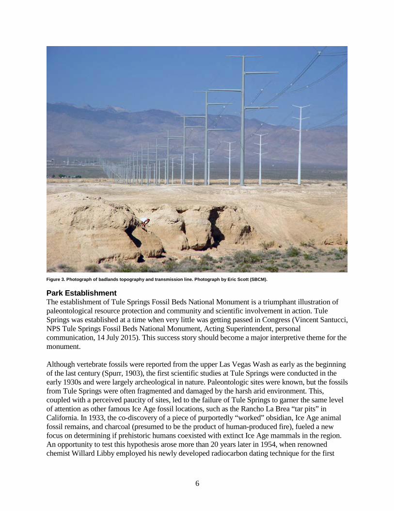
Geologic Setting Tule Springs Fossil Beds National Monument is largely within the upper Las Vegas Wash—a 13-mile northwest–southeast trending tributary of the Colorado River, the major drainage running through the city of Las Vegas and beyond to Lake Mead (fig. 2). The basin occupied by the Las Vegas Wash was formed by extensional tectonics associated with the Las Vegas Valley shear zone less than 15 million years ago (Fleck 1970). The landscape within the upper Las Vegas Wash is a highly eroded, badlands-type topography of mostly light-colored, fine-grained groundwater discharge deposits (fig. 3). The wash was firmly entrenched by the early Holocene (~8,000 years ago) and has probably remained active since that time (Jeff Pigati, USGS, geologist, personal communication, 1 September 2015). Tule Springs Fossil Beds National Monument is bounded to the northeast by the Sheep and Las Vegas mountain ranges and to the southwest by the Spring Mountains (fig. 2). The mountain ranges are comprised predominantly of ancient carbonate rocks (e.g., dolomite, limestone) as well as chert and shale, all of which formed during the Paleozoic Era (mainly the Mississippian Period, ~345 million years ago) when a vast ocean covered much of North America. The mountains themselves were raised during the Sevier Orogeny which took place between approximately 140 million and 50 million years ago. Erosion of the mountains has created an extensive border of alluvial fans which descend from the ranges, widen, and extend into the monument (fig. 2). Within the boundaries of Tule Springs Fossil Beds National Monument, there are three categories of geologic deposits: 1) Pleistocene, groundwater discharge-related deposits (referred to on geologic maps as the “fine-grained deposits of Tule Springs” or the “Las Vegas Formation”), 2) alluvial fan deposits, and 3) recent upper Las Vegas Wash alluvial and fluvial deposits. The Pleistocene deposits contain fossils of extinct Ice Age animals and plants and are composed of clay, silt, and fine sand that were deposited in spring-fed ponds, meadows, marshes, and streams in association with groundwater discharge events during periods of abundant rainfall (pluvials) in the Pleistocene Epoch (Ramelli et al. 2011). Erosion within the upper Las Vegas Wash has exposed these sediments and they also crop out on the upthrown side of the Eglington Fault scarp (Ramelli et al. 2011). The alluvial fan deposits, which border the wash, consist mainly of Paleozoic-age carbonate sand and gravel; deposition began in the early Pleistocene Epoch and continues today as the mountains erode. The recent upper Las Vegas Wash deposits are the youngest deposits in the monument. The deposits are fine- to coarse-grained material reworked from the Pleistocene deposits and alluvial fans, as well as other minor sources (e.g., eolian sediments) (Ramelli et al. 2011).
4

Figure 2. Aerial photograph of Tule Springs Fossil Beds National Monument. The monument boundary is represented by the green line. The upper Las Vegas Wash is the buff colored area. The Sheep and Las Vegas mountain ranges are northeast of the monument and the Spring Mountains are to the southwest. The alluvial fans appear as gray and red material that extends from the base of the mountain ranges toward the wash.
5
Park Establishment The establishment of Tule Springs Fossil Beds National Monument is a triumphant illustration of paleontological resource protection and community and scientific involvement in action. Tule Springs was established at a time when very little was getting passed in Congress (Vincent Santucci, NPS Tule Springs Fossil Beds National Monument, Acting Superintendent, personal communication, 14 July 2015). This success story should become a major interpretive theme for the monument. Although vertebrate fossils were reported from the upper Las Vegas Wash as early as the beginning of the last century (Spurr, 1903), the first scientific studies at Tule Springs were conducted in the early 1930s and were largely archeological in nature. Paleontologic sites were known, but the fossils from Tule Springs were often fragmented and damaged by the harsh arid environment. This, coupled with a perceived paucity of sites, led to the failure of Tule Springs to garner the same level of attention as other famous Ice Age fossil locations, such as the Rancho La Brea “tar pits” in California. In 1933, the co-discovery of a piece of purportedly “worked” obsidian, Ice Age animal fossil remains, and charcoal (presumed to be the product of human-produced fire), fueled a new focus on determining if prehistoric humans coexisted with extinct Ice Age mammals in the region. An opportunity to test this hypothesis arose more than 20 years later in 1954, when renowned chemist Willard Libby employed his newly developed radiocarbon dating technique for the first
6
Figure 3. Photograph of badlands topography and transmission line. Photograph by Eric Scott (SBCM).
time in the United States. Libby dated a piece of charcoal found with the obsidian flake and megafaunal fossil remains from the original site in Tule Springs. The results indicated that the charcoal, dated to between 33,000 and 28,000 years before present, was far older than any known occurrence of early humans in North America at that time. (Currently, the earliest firm evidence for early humans in North America stands at ~14,300 years before present). The charcoal from Tule Springs therefore cannot have been the product of the use of fire by humans, but this would not have been known in Libby’s day. Based upon Libby’s dates, the quest for the human/megafaunal connection received new impetus, renewing the search for more artifacts and associated fossil bones with the aim of establishing a more detailed chronology using the new radiocarbon technique. As a consequence of this, from 1962–1963, the aptly-named “Big Dig” was launched. Funded by the National Science Foundation (NSF) and National Geographic, this multidisciplinary effort involved vertebrate paleontologists, archaeologists and geologists in one of the largest such investigations ever conducted (it was the largest NSF-funded project at that time). Bulldozers and scrapers gouged huge trenches across the wash to facilitate the archeological excavation as well as to understand the complex subsurface stratigraphy; these trenches were so massive that they were subsequently included on the National Register of Historic Places in 1979 (fig. 4). These geologic investigations convincingly demonstrated that there was no temporal association with the human cultural artifacts and the Pleistocene megafauna. With the loss of the potential Pleistocene human–megafauna connection, interest in the Tule Springs site waned. Long managed as public lands by the Bureau of Land Management (BLM), by the early 2000s the Tule Springs area was designated by public law as a “disposal area” which the BLM could sell in order to accommodate population growth in North Las Vegas. However, before the BLM could sell the land, they were required to conduct environmental analyses which included documenting federally protected resources (e.g., fossils, threatened and endangered species, etc.) and evaluating any potential impacts to these resources (e.g., loss of a nonrenewable resource) if the property was sold. An Environmental Impact Statement (EIS) was also needed to assess impacts from a proposed (now constructed) electricity transmission line across the Las Vegas Wash (fig. 3). Between 2003 and 2004, scientists from the San Bernardino County Museum (contracted by the BLM) identified 438 previously unrecognized fossil localities in the Tule Springs area. This demonstrated conclusively the real paleontologic wealth of the region, and consequently the true extent and significance of the fossils at Tule Springs finally achieved their fully warranted recognition (Scott et al. 2015). The BLM EIS (2010) identified “high concentrations of sensitive natural, cultural, and paleontological resources” in the upper Las Vegas Wash; because of this, the BLM withheld 13,622 acres from sale in order to conduct further study. These actions ultimately led to the designation of Tule Springs Fossil Beds National Monument.
7

Geologic Mapping for Tule Springs Fossil Beds National Monument GRI’s digital geologic maps reproduce all aspects of paper maps, including notes, legend, and cross sections, with the added benefit of being GIS compatible. The NPS GRI Geology-GIS Geodatabase Data Model incorporates the standards of digital map creation for the GRI and allows for rigorous quality control. Staff members digitize maps or convert digital data to the GRI digital geologic map model using ESRI ArcGIS software. Final digital geologic map products include data in geodatabase and shapefile format, layer files complete with feature symbology, Federal Geographic Data Committee (FGDC)–compliant metadata, a PDF help file that captures ancillary map data, and a document that displays the map. Final data products are posted at http://science.nature.nps.gov/nrdata/. The data model is available at http://science.nature.nps.gov/im/inventory/geology/GeologyGISDataModel.cfm. When possible, the GRI provides large scale (1:24,000) digital geologic map coverage for each National Park System unit’s area of interest, which is often composed of the 7.5-minute quadrangles that contain parklands. Maps at a scale of 1:24,000 (and larger) are useful for resource management because they capture most geologic features of interest and are spatially (horizontally) accurate to within 12 m (40 ft). The area of interest for Tule Springs Fossil Beds National Monument covers
8
Figure 4. Photograph of excavated trench during the “Big Dig” of 1962–1963. Photo courtesy of Eric Scott from the archival photos of the San Bernardino County Museum Division of Anthropology.

four quadrangles (Gass Peak SW, Tule Springs Park, Corn Creek Springs, and Corn Creek Springs NW), all of which have at least some published geologic map coverage (fig. 5). Kathleen Springer indicated that the two older maps (Corn Creek Springs and Tule Springs Park quadrangles) will require revision and that all four could benefit from updates prior to being used as sources for the GRI map product. In order to be useful to resource managers, a scale of 1:12,000 for the monument, and 1:3,000 for parts of both the North and South Unit, including areas that would need information at that scale for visitor interpretative purposes (e.g., the original Tule Springs site) would be ideal (see GRI geologic map for John Day Fossil Beds National Monument available at https://irma.nps.gov/App/Reference/Profile/2171373, accessed 14 September 2015). Geologic mapping at this scale has not yet been done at Tule Springs, but some finer details are available on hand drawn maps (Kathleen Springer, USGS, geologist, personal communication, 14 July 2015). The alluvial fan stratigraphy has probably not changed much since the publication of the maps that cover the quadrangles of interest for the monument (Jim Schmitt, Montana State University, geologist, personal communication, 14 July 2015) and, therefore, the additional mapping efforts would be largely restricted to the ground-water discharge deposits in the wash area. Because fossils likely extend well beyond the boundaries of Tule Spring Fossil Beds National Monument, additional map coverage may be useful for resource managers. Vincent Santucci indicated he would look into how much the map should be extended beyond the monument’s boundary. Meeting participants concluded that all four quadrangle maps need to be updated and integrated into one cohesive product (seamless across quads) and that the alluvial fan stratigraphy on the perimeter of the maps should be included in this integration. A map of just the tufa system also exists, and should be incorporated into the GRI map product as well. The Southern Nevada Public Land Management Act provides funding specifically for Nevada public lands projects and this funding source may be appropriate for mapping support.
9

Figure 5. Area of interest for Tule Springs Fossil Beds National Monument. Four quadrangles of interest were identified for Tule Springs Fossil Beds National Monument. These 7.5-minute quadrangles (scale 1:24,000) are labeled in red. The orange boundary indicates the 30-minute by 60-minute Las Vegas sheet (scale 1:100,000), which also covers the area of interest. The green outline shows the NPS boundary of Tule Springs Fossil Beds National Monument. NPS graphic by Rebecca Port (NPS Geologic Resources Division).
Table 2. GRI mapping for Tule Springs Fossil Beds National Monument
Covered Quadrangles GMAP1 Citation2 Scale Format Assessment GRI Action
Corn Creek Springs, NV 7.5
29565 Bell et al. (1999) 1:24,000 PDF Best available map, but will need significant revision.
Convert to GRI data model.
Corn Creek Springs NW, NV 7.5
76014 Ramelli et al. (2012) 1:24,000 PDF Best available map, but will need minor revision.
Convert to GRI data model.
Gass Peak SW, NV 7.5 76015 Ramelli et al. (2011) 1:24,000 PDF Best available map, but will need minor revision.
Convert to GRI data model.
Tule Springs Park, NV 7.5 29445 Bell et al. (1998) 1:24,000 GIS PDF
Best available map, but will need significant revision.
Convert to GRI data model.
1GMAP numbers are unique identification codes used in the GRI database. 2See “Literature Cited” section for full citations.
10
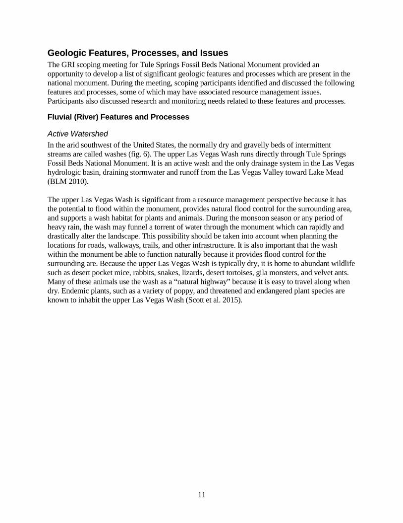
Geologic Features, Processes, and Issues The GRI scoping meeting for Tule Springs Fossil Beds National Monument provided an opportunity to develop a list of significant geologic features and processes which are present in the national monument. During the meeting, scoping participants identified and discussed the following features and processes, some of which may have associated resource management issues. Participants also discussed research and monitoring needs related to these features and processes.
Fluvial (River) Features and Processes
Active Watershed In the arid southwest of the United States, the normally dry and gravelly beds of intermittent streams are called washes (fig. 6). The upper Las Vegas Wash runs directly through Tule Springs Fossil Beds National Monument. It is an active wash and the only drainage system in the Las Vegas hydrologic basin, draining stormwater and runoff from the Las Vegas Valley toward Lake Mead (BLM 2010). The upper Las Vegas Wash is significant from a resource management perspective because it has the potential to flood within the monument, provides natural flood control for the surrounding area, and supports a wash habitat for plants and animals. During the monsoon season or any period of heavy rain, the wash may funnel a torrent of water through the monument which can rapidly and drastically alter the landscape. This possibility should be taken into account when planning the locations for roads, walkways, trails, and other infrastructure. It is also important that the wash within the monument be able to function naturally because it provides flood control for the surrounding are. Because the upper Las Vegas Wash is typically dry, it is home to abundant wildlife such as desert pocket mice, rabbits, snakes, lizards, desert tortoises, gila monsters, and velvet ants. Many of these animals use the wash as a “natural highway” because it is easy to travel along when dry. Endemic plants, such as a variety of poppy, and threatened and endangered plant species are known to inhabit the upper Las Vegas Wash (Scott et al. 2015).
11

Vestige of the Upper Las Vegas Wash Landscape Las Vegas Wash sediments probably underlie most of the Las Vegas Valley. As a result of population growth and subsequent development, the once expansive wash has been reduced to a much smaller area and large portions of it have been covered by homes and businesses (fig. 2). This trend is likely to continue, except where lands are protected such as at Tule Springs Fossil Beds National Monument. Thus, the monument can be considered a last vestige of this once widespread landscape.
Ancient Fluvial Processes During the Pleistocene Epoch, fluvial processes in the Tule Springs area were much different than they are today and included streams emanating from springs. These streams deposited the sediment (see Stratigraphic Features section) in which fossils (see Paleontological Resources section) as well as braided fluvial tufa deposits (see Tufa Deposits section) are now found.
12
Figure 6. Photograph of the upper Las Vegas Wash in the monument. Desert washes typically flow intermittently. Mud crack and ripple marks (visible in the photo) are evidence of water in the wash. NPS photograph by Jason Kenworthy (Geologic Resources Division).

Lacustrine (Lake) Features and Processes Today, the only lacustrine features in Tule Springs Fossil Beds National Monument are small and ephemeral/perennial “playas”, which do not hold water for significant amounts of time. They could be considered a hazard to cars driving off-road after heavy rainfall. The groundwater discharge (or wetland) deposits in the monument were initially attributed to “Pluvial Lake Las Vegas” (Maxey and Jameson 1948; Bowyer et al. 1958; Longwell 1961), although subsequent work by Haynes (1967), Quade (1986), and others have shown this not to be the case. In fact, there is no evidence to support the existence of a large lake in the valley at any time during the Quaternary.
Paleontological Resources Tule Springs Fossil Beds National Monument is one of 260 NPS areas with documented fossils and “may be considered among the most significant late Pleistocene paleontological sites in the American Southwest” (BLM 2010, p. 3). The fossils range in age from about 100,000 to 11,000 years old and include the remains of extinct Ice Age species of animals such as Columbian mammoth, ground sloth, camel, bison, horse, sabre-toothed cat, lynx, dire wolf, marmot, harvest mouse, wood rat, snake, and frog (Scott et al. 2015). Freshwater mollusks, including clams and snails, as well as plant macrofossils, pollen, and charcoal have also been recovered from the sediments. Trace fossils include preserved cicada burrows (fig. 7). The density of these burrows in one location is quite stunning and could serve as an excellent interpretive feature in the monument. In addition to the San Bernardino County Museum, sizeable fossil collections from Tule Springs are housed at the Nevada State Museum, the University of California Museum of Paleontology (Berkeley), and the American Museum of Natural History (AMNH). Other institutions hold smaller collections from the site; the Autry Museum in Los Angeles houses collections from Mark Harrington and the old Southwest Museum; the Santa Barbara Museum of Natural History retains a few specimens; the University of Arizona holds some pollen samples; there are a few drawers of specimens at the Natural History Museum of Los Angeles County; and one bison skull resides at the Canadian Museum of Nature (transferred from the AMNH in 1936; Fabian Hardy, Geoscientists-in-the-Parks, intern, personal communication, 1 September 2015). In June 2015, a large fossil collection (approximately 10,000 specimens from the 2001-2003 transmission line survey) was legally transferred from the Bureau of Land Management to the National Park Service and the fossils were transported from the San Bernardino County Museum in California to the Nevada State Museum. All of the fossils discovered in the monument were found within Pleistocene-aged wetland deposits related to groundwater discharge events. Fossils from Tule Springs are therefore usually not as well preserved or abundant as those from caves and/or asphalt deposits such as the Rancho La Brea “tar pits” (fig. 8; Scott et al. 2015). Tule Springs and the upper Las Vegas Wash do however preserve the largest open Ice Age land mammal fauna from the Mojave Desert and Great Basin (Scott et al. 2015). The fossils are relatively abundant and span nearly 100,000 years, making the Tule Springs assemblage ideal for assessing and interpreting how Pleistocene terrestrial communities responded to climate change through time (Scott et al. 2015). This unique combination of plant and animal fossils provides uncommon educational and study opportunities which are likely to attract international interest.
13

The San Bernardino County Museum (Eric Scott, Kathleen Springer, and Craig Manker) conducted paleontological research beginning in 2001, most recently with funding by the BLM from 2008–2014. Recent reporting to the BLM at the cessation of that study included a comprehensive baseline inventory (documenting all types of fossils, not just megafauna) with a map, and the radiocarbon and luminescence data that contributed to the effort to date every geologic unit that contains fossils. Currently, the US Geological Survey (Kathleen Springer, Craig Manker, and Jeff Pigati) is conducting expanded geochronology and lithostratigraphy studies of the deposits. Multiple scientific publications on these topics, both paleontologic and geologic, are forthcoming. Other projects include work by Geoscientist-in-the-Parks interns, Aubrey Bonde and Fabian Hardy, who are compiling bibliographies of paleontology publications and geology publications, respectively, associated with the assemblage at Tule Springs. Their results should be available in September 2015. Much research is still needed to answer the many questions remaining about the Tule Springs fossil assemblage and Pleistocene Ice Age in the desert Southwest. What can the fauna tell us about the environment, climate, and health of the ecosystem at the time they were alive? Did the fauna respond to the multiple climatic fluctuations documented at Tule Springs? Why did the animals not survive beyond the Ice Age? Did the introduction of bison, a large, aggressively-grazing animal, contribute to their extinction (Scott 2010; Scott et al. 2015)? Is there a connection between the Tule Springs and Colorado River faunas (Vincent Santucci, personal communication, 14 July 2015)? Are the fossils more common and/or better preserved in any particular unit? Resource management issues related to paleontological resources in the park include inventory, monitoring, and protection. The inventory component is already underway. A monitoring plan should be prepared to gain an understanding of the rate at which erosion in the wash is exposing paleontological resources. Strategies will be required to protect fossils from destruction while infrastructure is added to the monument and from illegal collecting as public knowledge of the monument and its resources grows.
14
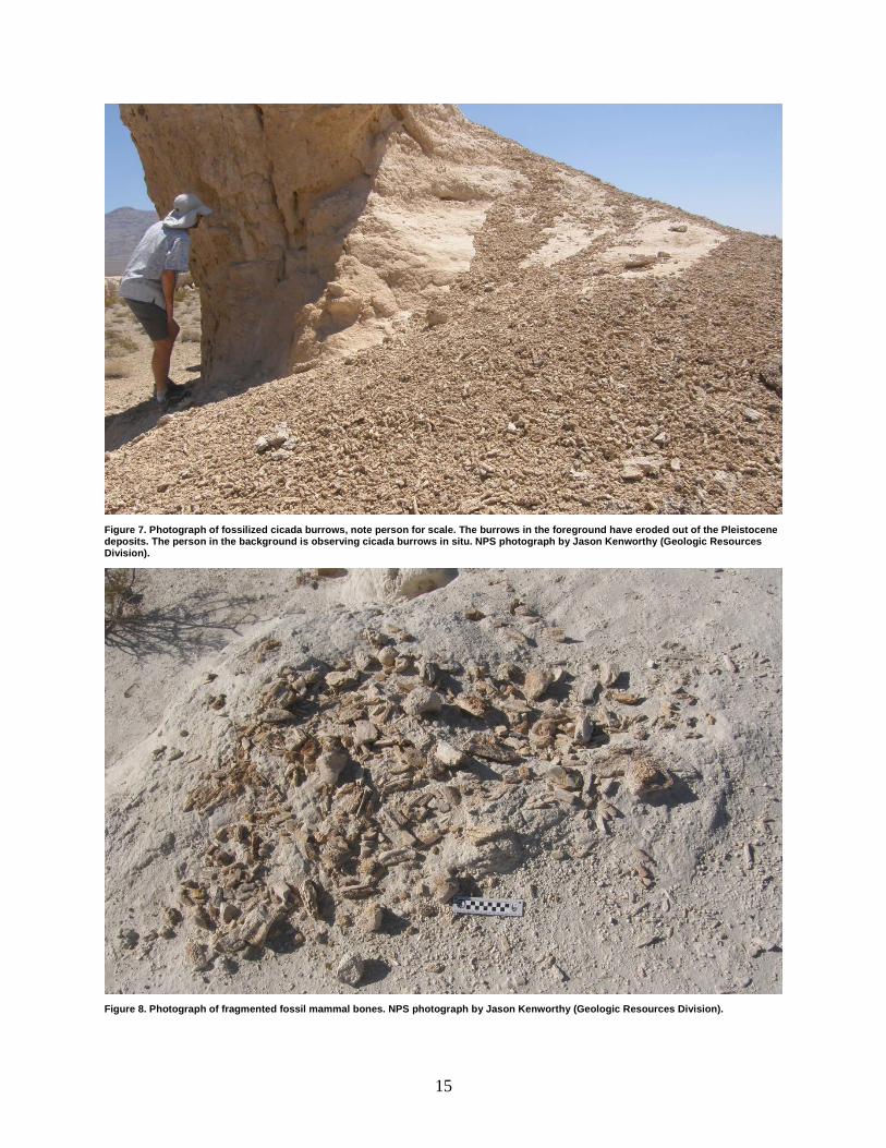
Figure 7. Photograph of fossilized cicada burrows, note person for scale. The burrows in the foreground have eroded out of the Pleistocene deposits. The person in the background is observing cicada burrows in situ. NPS photograph by Jason Kenworthy (Geologic Resources Division).
Figure 8. Photograph of fragmented fossil mammal bones. NPS photograph by Jason Kenworthy (Geologic Resources Division).
15
Record of Climate Change The Pleistocene groundwater discharge-related deposits at Tule Springs contain a spectacular record of climate change over the past 250,000 years or more, including multiple cool and warm periods. In general, the Pleistocene Epoch in the area of Tule Springs was cooler and wetter than it is today, although climate was highly variable. Each distinct paleo-wetland unit is associated with a discrete groundwater discharge event that reflected a change in climate and either the expansion or contraction of desert wetlands (Springer et al. 2015). Springs tended to discharge groundwater during cool, wet times and these events were punctuated by abrupt and brief episodes of aridity and/or erosion (Springer et al. 2015). Paleosols and carbonate caps are extremely important features in the strata marking abrupt climate change (Springer et al. 2015). Carbonate caps formed quickly (over a couple thousand years) and represent wet meadow or marsh-like conditions. Notably, even though their appearance is similar to soil caliche, they are not formed under the same conditions.
Stratigraphic Features Tule Springs contains one of the longest continuous sections of Pleistocene wetland strata in the southwest, spanning 250,000 to 7,000 years before present. Dr. C. Vance Haynes Jr., the lead geologist on the “Big Dig” and archeological excavations in the 1960s, completed the original chronology and stratigraphic framework for the Pleistocene groundwater discharge-related deposits of Tule Springs (see Haynes 1967). Current research by the US Geological Survey is focused on refining the stratigraphy and chronology via radiocarbon and luminescence dating; their findings will be published in the near future. At the scoping meeting, US Geological Survey researchers (Kathleen Springer, Craig Manker, and Jeff Pigati) discussed several noteworthy stratigraphic features (described briefly below), which will be a part of their forthcoming publications. The wetland stratigraphy is very complex. Many of the contacts between layers of deposits are separated by a period of erosion or non-deposition that results in missing time; these are called “unconformities.” For example, overlying deposits frequently fill channels that were eroded onto the surface of lower units. The contact between the two deposits is therefore not a flat plane but rather an undulating surface which represents the time between channel-infilling. This can make it very difficult to follow and recognize a single deposit over a large area. Adding to this complexity is the fact that as one follows a deposit orthogonal to the valley axis, sedimentary facies change. In other words, deposits in the valley axis that might represent relatively wet conditions grade upslope into deposits away from the axis that represent relatively dry conditions. This results in a series of deposits that are the same age but look quite different depending on where you are in the valley. Stratigraphic work conducted by Kathleen Springer, Craig Manker, and colleagues (Springer, Manker, formerly at SBCM, now USGS) demonstrated that the spring discharge deposits resulted from several different “styles” of spring discharge events. These styles include rheocrene (spring flows from a defined opening into a confined channel), limnocrene (spring originates from a large, deep pool of water), and helocrene (spring originates from a marsh or bog) discharge. Hiatuses in spring discharge deposits reflect aridisols (dark layers) or erosion events (Springer et al. 2015). Corn Creek Springs, managed by the US Fish and Wildlife Service on the adjacent Desert National Wildlife Refuge, is considered a modern analog to the Pleistocene spring discharge deposits in the monument (Vincent Santucci, personal communication, 2 September 2015).
16

Inverted Paleotopography Inverted paleo-stream channel topography is an erosional feature of the landscape at Tule Springs Fossil Beds National Monument. During the Pleistocene Epoch gravel became deposited in stream channels emanating from springs. As time passed, the environment changed and the streams dried up leaving the entire area exposed to erosion. The gravel, being larger and heavier than adjacent non-stream bed sediments was more resistant to erosion than the surrounding fine-grained sediments. The former stream channels were protected from erosion by the layer of gravel while the surrounding land eroded down, which ultimately left the channels exposed above the surrounding landscape, essentially inverted from the way they originally existed. The inverted paleo-stream channel topography provides a way to reconstruct the distribution of Pleistocene stream channels and it also protects the sediments underlying the gravel, many of which contain fossils.
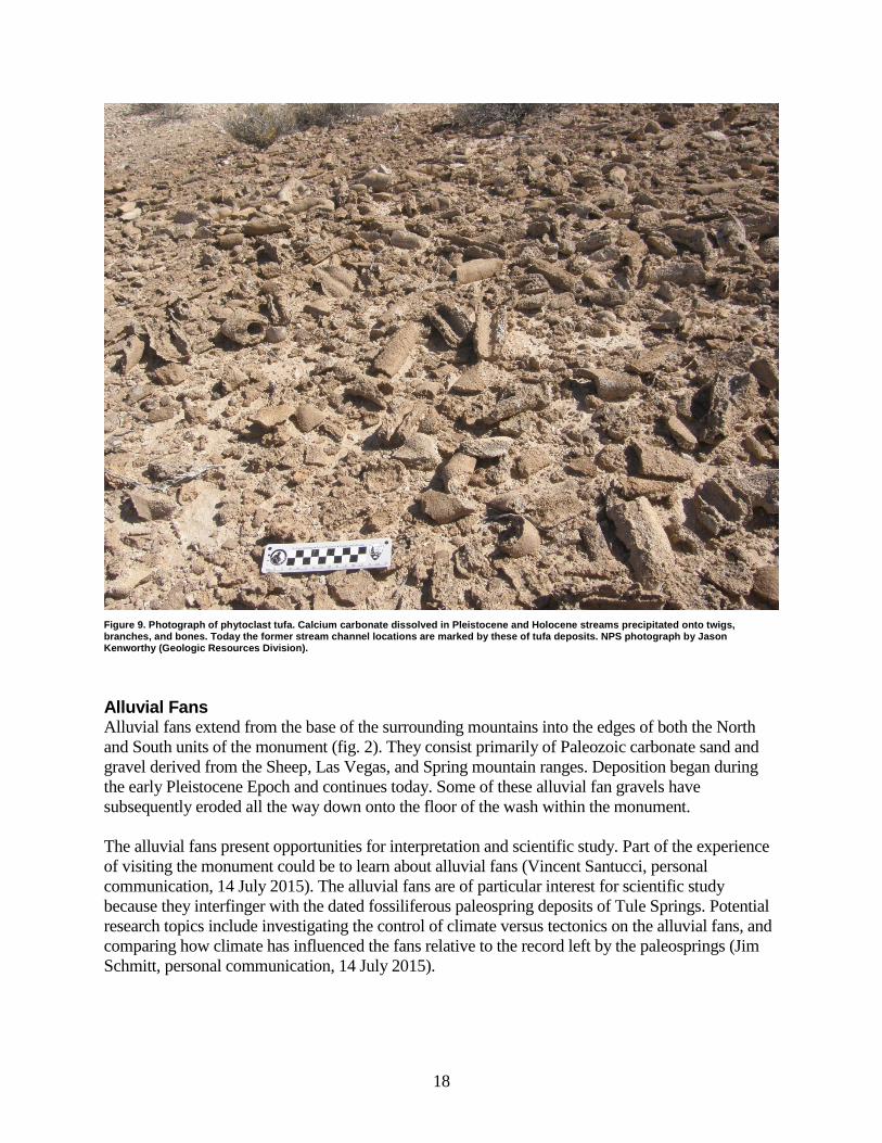
Tufa Deposits During the late Pleistocene Epoch (~21,000 to 10,600 years before present), braided streams rich in dissolved calcium carbonate emanated from springs (groundwater discharge locations) throughout the valley. As the streams flowed, calcium carbonate precipitated out of the water forming tufa deposits. These dark brown, tufa deposits have been preserved in the rock record at Tule Springs and because the tufa is harder and coarser than the surrounding sediments it remains while other sediments are eroded, leaving an inverted-type of topography that mimics the flow patterns of the the latest Pleistocene and Holocene braided streams. In many cases the tufa precipitated onto tree branches and limbs that were likely dangling into the river; these features are called phytoclasts (fig. 9). The plant material is long gone, but the tufa remains as a mold. The tufa has also been found encrusting bones, tusks, and shells. The winding and braided nature of the paleo-channel is observable in the distribution of the tufa and is frozen in time. The tufa formations in the monument exhibit a variety of morphologies (e.g., oncoids, stromatolitic tufa, tufa crusts, tufa coated clasts, cyanoliths, and resurgence features) which is interpreted as a response to different hydrologic environments. Tufa deposits are best exposed near the Eglington Preserve and fault/scarp area where the tufa lag deposits have been thoroughly exposed; in the North Unit, tufa is still in the process of weathering out of the landscape. The paleo-channels in the South Unit were up to several miles long, but have been largely destroyed by urban development and installation of a water line in 2004–2005. There is no evidence that the tufa or other wetland deposits in the Las Vegas Valley were influenced by geothermal heating. Such ambient-temperature precipitation of tufa can be observed at Cold Creek in the Spring Mountains today.
17
Alluvial Fans Alluvial fans extend from the base of the surrounding mountains into the edges of both the North and South units of the monument (fig. 2). They consist primarily of Paleozoic carbonate sand and gravel derived from the Sheep, Las Vegas, and Spring mountain ranges. Deposition began during the early Pleistocene Epoch and continues today. Some of these alluvial fan gravels have subsequently eroded all the way down onto the floor of the wash within the monument. The alluvial fans present opportunities for interpretation and scientific study. Part of the experience of visiting the monument could be to learn about alluvial fans (Vincent Santucci, personal communication, 14 July 2015). The alluvial fans are of particular interest for scientific study because they interfinger with the dated fossiliferous paleospring deposits of Tule Springs. Potential research topics include investigating the control of climate versus tectonics on the alluvial fans, and comparing how climate has influenced the fans relative to the record left by the paleosprings (Jim Schmitt, personal communication, 14 July 2015).
18
Figure 9. Photograph of phytoclast tufa. Calcium carbonate dissolved in Pleistocene and Holocene streams precipitated onto twigs, branches, and bones. Today the former stream channel locations are marked by these of tufa deposits. NPS photograph by Jason Kenworthy (Geologic Resources Division).
Eolian (Windblown) Features and Processes Eolian processes involve windblown sediment and include features such as dunes and dust. Dunes are present in Tule Springs Fossil Beds National Monument and are represented on the potential source maps (see Geologic Mapping section) as middle to late Holocene, “well sorted eolian sand, typically forming stabilized, vegetated dunes up to 5m (16 ft) high and with minimal to no soil development” (Ramelli et al. 2011, p. 3). This type of simple dune that forms around vegetation is known as a coppice (or nebkha) dune. Management issues related to eolian features in the monument include protection of archeological resources associated with the coppice dunes and the mitigation of dust generated during construction activites (e.g., paving of Corn Creek Road through the monument). Geologic dust (as opposed to human-caused dust) is prevalent in the geologic record at Tule Springs and makes up a large component of the groundwater discharge deposits. Dust is trapped in wetlands by a combination of wet ground conditions and dense plant cover, making wetlands very efficient dust traps in the desert. US Geological Survey studies to characterize the geochemical signature of the dust are ongoing.
Caves and Karst There is no karst in Tule Springs Fossil Beds National Monument. Many openings are eroded into the steep walls of the wash and could be considered caves, but it is doubtful that any would meet the criteria for “significant cave” as defined in the Federal Cave Resource Protection Act (available at https://www.law.cornell.edu/uscode/text/16/chapter-63, accessed 20 August 2015). A formal cave inventory and assessment has not yet been completed at the monument.
Geothermal Features There are no geothermal features or activity in Tule Springs Fossil Beds National Monument. However, geothermal systems are known to exist nearby in Lake Mead National Recreation Area.
Cultural Resources in a Geologic Context Geologic materials, such as obsidian, used to make tools are documented from the monument (Scott et al. 2015). Cultural artifacts remaining from early studies of the Tule Springs strata are located alongside paleontological resources. The Old Spanish National Historic Trail passes through the Las Vegas Valley, but its exact location is uncertain. A portion of the trail may have passed through the monument because people would have migrated along any path that had vegetation or water.
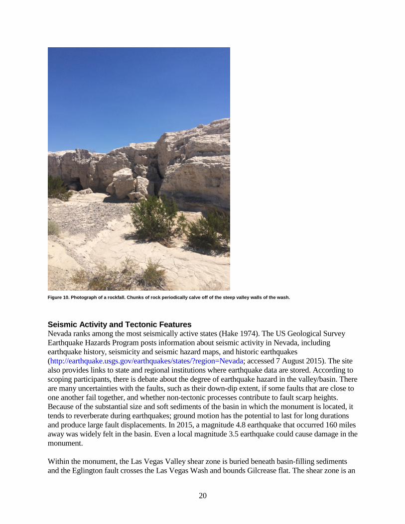
Slope Movements Large chunks of rock routinely calve off of the naturally steep walls of the wash (fig. 10). Some of the trenches that were bulldozed during the 1960s “Big Dig” excavation have steep and unstable walls (fig. 4). At the same time, these trenches also have interpretive potential (e.g., type sections established and radiocarbon dates obtained here). Resource managers will need to determine if any trenches should be stabilized or if natural slope movement processes should be allowed to continue. Steep walls, natural or manufactured, are a safety hazard and visitors and staff should be directed to avoid such areas.
19
Seismic Activity and Tectonic Features Nevada ranks among the most seismically active states (Hake 1974). The US Geological Survey Earthquake Hazards Program posts information about seismic activity in Nevada, including earthquake history, seismicity and seismic hazard maps, and historic earthquakes (http://earthquake.usgs.gov/earthquakes/states/?region=Nevada; accessed 7 August 2015). The site also provides links to state and regional institutions where earthquake data are stored. According to scoping participants, there is debate about the degree of earthquake hazard in the valley/basin. There are many uncertainties with the faults, such as their down-dip extent, if some faults that are close to one another fail together, and whether non-tectonic processes contribute to fault scarp heights. Because of the substantial size and soft sediments of the basin in which the monument is located, it tends to reverberate during earthquakes; ground motion has the potential to last for long durations and produce large fault displacements. In 2015, a magnitude 4.8 earthquake that occurred 160 miles away was widely felt in the basin. Even a local magnitude 3.5 earthquake could cause damage in the monument. Within the monument, the Las Vegas Valley shear zone is buried beneath basin-filling sediments and the Eglington fault crosses the Las Vegas Wash and bounds Gilcrease flat. The shear zone is an
20
Figure 10. Photograph of a rockfall. Chunks of rock periodically calve off of the steep valley walls of the wash.
extinct Tertiary extensional structure with last movement in the Neogene Period (Kathleen Springer, personal communication, 3 September 2015), although buried faults that are associated with it may still be capable of producing earthquakes that could impact the monument. The Eglington Fault is an active Quaternary fault that offsets the fine-grained deposits associated with past groundwater discharge. It has a slip rate of approximately 0.25–0.6 mm/yr (0.01–0.02 in/yr), which is relatively high for a short-length intrabasinal fault (dePolo et al. 2013). Total offset is currently 18–20 meters (59–66 feet) and the fault has become more active since the late Pleistocene Epoch (dePolo et al. 2013). The Eglington fault, therefore, dominates the earthquake hazard in the monument. Research needs include more seismic monitoring which would produce a better understanding of the earthquake hazard. At present there are no monitoring stations in the northern part of the Las Vegas basin and the Nevada Seismology Laboratory would recommend installing one in the monument. Additionally, research could look at the influence the Eglington fault is having or has had on the landscape and biota of the monument. Certain threatened and endangered species are only found in the monument in the area of the fault (see dePolo et al. 2013).
Land Subsidence Land in the Las Vegas Valley has been subsiding due to the extraction of groundwater since about 1935 (Bell and Helm 1998; Hernandez-Marin and Burbey 2012). This potential issue should be considered when planning and designing monument infrastructure.
Disturbed Lands and Viewshed The Tule Springs area has been used for more than three decades for intensive firearms target practice with almost every type of weapon imaginable (Vincent Santucci, personal communication, 14 July 2015). This may have led to lead and debris accumulation in the ground which could require remediation. An Environmental Protection Agency assessment for Superfund site designation may be warranted (Vincent Santucci, personal communication, 14 July 2015). Illegal dumping has also created disturbed lands (Vincent Santucci, personal communication, 14 July 2015). Part of the experience at Tule Springs Fossil Beds National Monument is the geologic view. Disturbed areas near Decatur Blvd have disturbed the viewshed in the South Unit. However, this area provides a wonderful example of the urban interface that is unique to the monument and demonstrates how the march of urbanization was stopped just in time to save the remaining fossil beds. In contrast, the viewshed in the North Unit is largely intact.
External Energy Development The Paiute Snow Mountain renewable energy project has been proposed on the opposite side of highway 95 from the North Unit of Tule Springs Fossil Beds National Monument. Planning for the project will likely begin in 2017. If this project moves forward, it is also likely that the group will want to install additional transmission lines in or near the monument. A new transmission line would have to be constructed within 15 years or else they lose the opportunity permanently. Resource managers should be aware of this potential conflict that may occur in the next 15 years.
21
Literature Cited Bell, J.W., and D. C. Helm. 1998. Ground cracks on Quaternary faults in Nevada—–hydraulic
and tectonic. Pages 165–173 in J. W. Borchers, editor. Land subsidence case studies and current research. Proceedings of Dr. Joseph F. Poland Symposium on Land Subsidence. Association of Engineering Geologists, Special Publication, no. 8.
Bell, J. W., A. R. Ramelli, and S. J. Caskey. 1998. Geologic map of the Tule Springs Park
quadrangle, Nevada. Map 113. Nevada Bureau of Mines and Geology. Available at http://ngmdb.usgs.gov/Prodesc/proddesc_26365.htm (accessed 10 August 2015).
Bell, J. W., A. R. Ramelli, C. M. dePolo, F. Maldonado, and D. L. Schmidt. 1999. Geologic map
of the Corn Creek Springs quadrangle, Nevada. Map 121. Nevada Bureau of Mines and Geology. Available at http://ngmdb.usgs.gov/Prodesc/proddesc_26500.htm (accessed 10 August 2015).
Bowyer, B., E. H. Pampeyan, and C. R. Longwell. 1958. Geologic map of Clark County,
Nevada. Mineral Investigations Field Studies Map MF-138. US Geological Survey, Washington, D.C.
Bureau of Land Management. 2010. Draft Supplemental Environmental Impact Statement,
Upper Las Vegas Wash Conservation Transfer Area, Las Vegas, Nevada. Bureau of Land Management, Las Vegas Field Office, Las Vegas, Nevada.
dePolo, C. M., W. J. Taylor, and J. E. Faulds. 2013. Evidence for high contemporary slip rates
along the Eglington fault, Clark County, Nevada. Nevada Bureau of Mines and Geology Open-File Report 13-12, 8 p.
Fleck, R.J. 1970. Age and possible origin of the Las Vegas Valley shear zone, Clark and Nye
Counties, Nevada. Geological Society of America Abstracts with Programs, v. 2, p. 333. Haynes, C. V. 1967. Quaternary geology of the Tule Springs area, Clark County, Nevada.
Nevada State Museum, Antho. Papers no. 13, 104 p. Hernandez-Marin, M., and T. J. Burbey. 2012. Fault-controlled deformation and stress from
pumping-induced groundwater flow: Journal of Hydrology, v. 428–429, p. 80–93. Longwell, C. R. 1961. Geology of southern Nevada. Tule Springs, Nevada with other evidence
of Pleistocene man in North America. Paper no. 18. Southwest Museum, Los Angeles, California.
Maxey, G. B., and C. H. Jameson. 1948. Geology and water resources of Las Vegas, Pahrump,
and Indian Springs valleys, Clark and Nye counties, Nevada. Bulletin 5, 121 p. Nevada Bureau of Mines and Geology.
22
National Park Service. 2010. Upper Las Vegas Wash/Tule Springs, Nevada: reconnaissance report. U. S. Department of the Interior, National Park Service, Denver Service Center, Denver, Colorado.
Petersen, M. D., M. P. Moschetti, P. M. Powers, C. S. Mueller, K. M. Haller, A. D. Frankel,
Zeng, Yuehua, Rezaeian, Sanaz, S. C. Harmsen, O. S. Boyd, E. H. Field, Chen, Rui, Luco, Nicolas, R. L. Wheeler, R. A. Williams, A. H. Olsen, A.H., and K. S. Rukstales. 2015. Seismic-hazard maps for the conterminous United States, 2014. Scientific Investigations Map SIM-3325, 6 sheets, scale 1: 7,000,000. US Geological Survey, Washington, DC. Available at http://dx.doi.org/10.3133/sim3325 (accessed 17 August 2015).
Quade, J., 1986. Late Quaternary environmental changes in the upper Las Vegas Valley, Nevada.
Quaternary Research 26, 340-357. Ramelli, A. R., W. R. Page, C. R. Manker, and K. B. Springer. 2011. Geologic map of the Gass
Peak SW 7.5’ quadrangle, Clark County, Nevada. Map 175. Nevada Bureau of Mines and Geology. Available at http://pubs.nbmg.unr.edu/Geol-Gass-Peak-SW-quad-p/m175.htm (accessed 10 August 2015).
Ramelli, A. R., W. R. Page, C. R. Manker, and K. B. Springer. 2012. Preliminary geologic map
of the Corn Creek Springs NW 7.5’ quadrangle, Clark County, Nevada. Open File Report 2012-07. Nevada Bureau of Mines and Geology. Available at http://pubs.nbmg.unr.edu/Geol-Corn-Creek-Springs-NW-p/of2012-07.htm (accessed 10 August 2015).
Scott, E. 2010. Extinctions, scenarios, and assumptions: changes in latest Pleistocene large
herbivore abundance and distribution in western North America. Pages 225–239 in E. Scott and G. McDonald, editors. Faunal Dynamics and Extinction in the Quaternary: Papers Honoring Ernest L. Lundelius, Jr. Quaternary International 217.
Scott, E., K. Springer, and C. Manker. 2015. The Tule Springs local fauna: unearthing an Ice
Age wetlands ecosystem in southern Nevada. Unpublished presentation. Presented at the Geologic Resources Inventory scoping meeting for Tule Springs Fossils Beds National Monument, 14 July 2015.
Springer, K., C. Manker, E. Scott, J. Pigati, and S. Mahan. 2015. The geologic framework of
Tule Springs Fossil Beds National Monument. Unpublished presentation. Presented at the Geologic Resources Inventory scoping meeting for Tule Springs Fossils Beds National Monument, 14 July 2015.
Spurr, J.E. 1903. Descriptive geology of Nevada south of the Fortieth Parallel and adjacent
portions of California. United States Geological Survey Bulletin 208.
23


![Wonderful Christmas Medley (Reworked)[1]](https://img.dokumen.tips/doc/110x75/577cdf241a28ab9e78b09503/wonderful-christmas-medley-reworked1.jpg)


